MAPS AND AERIAL PHOTOS REVISION
|
|
|
- Juniper Foster
- 5 years ago
- Views:
Transcription
1 MAPS AND AERIAL PHOTOS REVISION IF THE FOLLOWING COMES UP IN THE SHORT QUESTIONS REMEMBER SCALE OF 1:1,100,000,000 MAP FROM A WORLD ATLAS LARGE AREAS WITH LITTLE DETAIL 1:250,000 SCALE OF CAR ATLAS MAP SCALE OF 1:50,000 YOUR EXAM MAP SMALL AREAS WITH GREAT DETAIL SCALE 1:1,000 STREET MAP OF NAAS

2


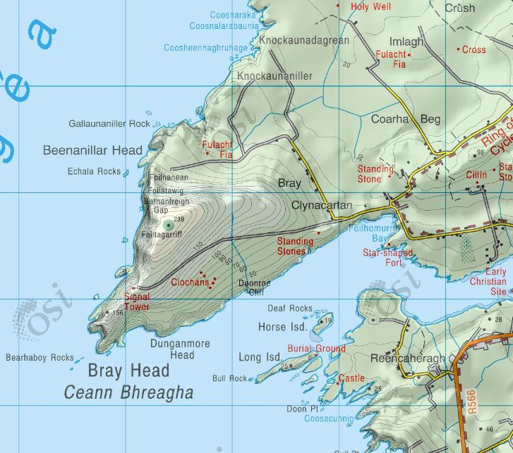
3 Headland Headla nd Cliff contours meet the coast Erosion features Bay Sea Stacks Headland


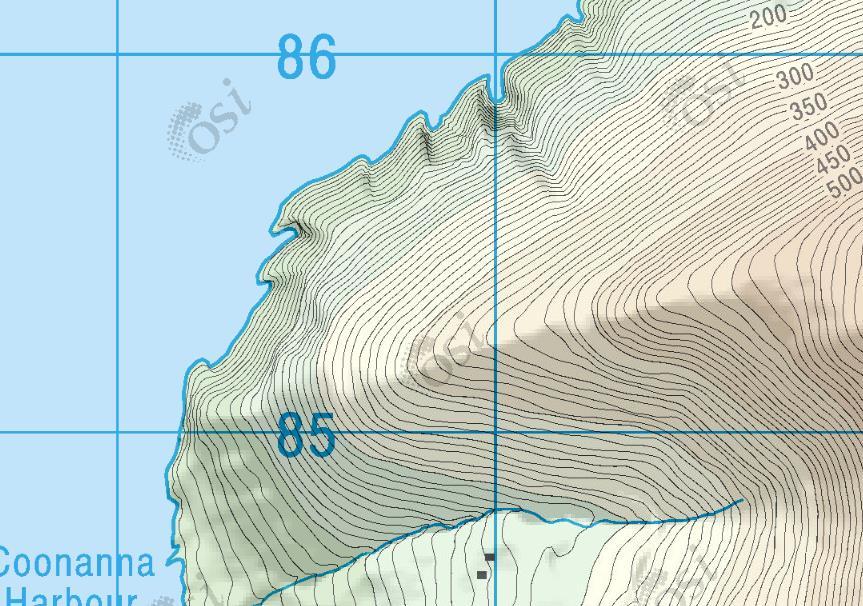
4 Contours meet the coastline indicating cliffs Inferred means we can presume they are there because they are The tighter the contour lines are, the steeper the cliffs are. Unless caves, arches or blowholes are named, they can be inferred along a coastline with cliffs
5
6
7
8
9


10 Tombolo Island is only fully accessible at low tide Crescent shaped beach


11 Yellow shading on map indicates permanent beach deposits Beach Purple/grey shading indicates deposits only visible at low tide Erne River keeps channel open Nose of sand spit is curved due to wave refraction Irregular contours indicate sand dunes


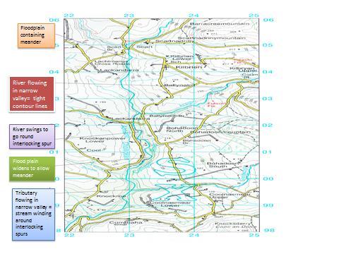
12 Sand spit Beach Irregular contour lines indicate sand dunes Tides and river currents keep the channel open Both sand spits have curved ends due to wave refraction Mud and silt deposited by tidal movements and river deposition
13

14 Sand dunes indicated by irregular contour lines Sandy beach area as indicated by yellow shading
15

16 Baymouth bar cuts off former bay area Lagoon


17 Irregular contour lines indicate sand dunes Nose of sand spit is curved towards the land due to wave refraction R Erne keeps channel open


18 FEATURES OF RIVER EROSION V SHAPED VALLEY, INTERLOCKING SPURS WATERFALL MEANDER DEPOSITION OX BOW LAKE LEVEE FLOOD PLAIN DELTA


19 River flowing in steep valley Small delta as river discharges into lake Meander as river flows in wide valley Lacustrine delta = river discharging into lake
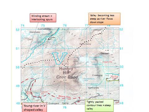
20
21

22 FEATURES OF GLACIAL EROSION CORRIE ARETE PYRAMIDAL PEAK ALL FOUND IN UPLAND AREAS U SHAPED VALLEY GLACIAL/ FLUVIOGLACIAL DEPOSITION ESKERS GLACIAL SPILLWAY DRUMLINS

23 Cirque found high up in mountainous areas brown shading tightly packed contour lines on 2/3 sides show steep sides or back wall of Corrie
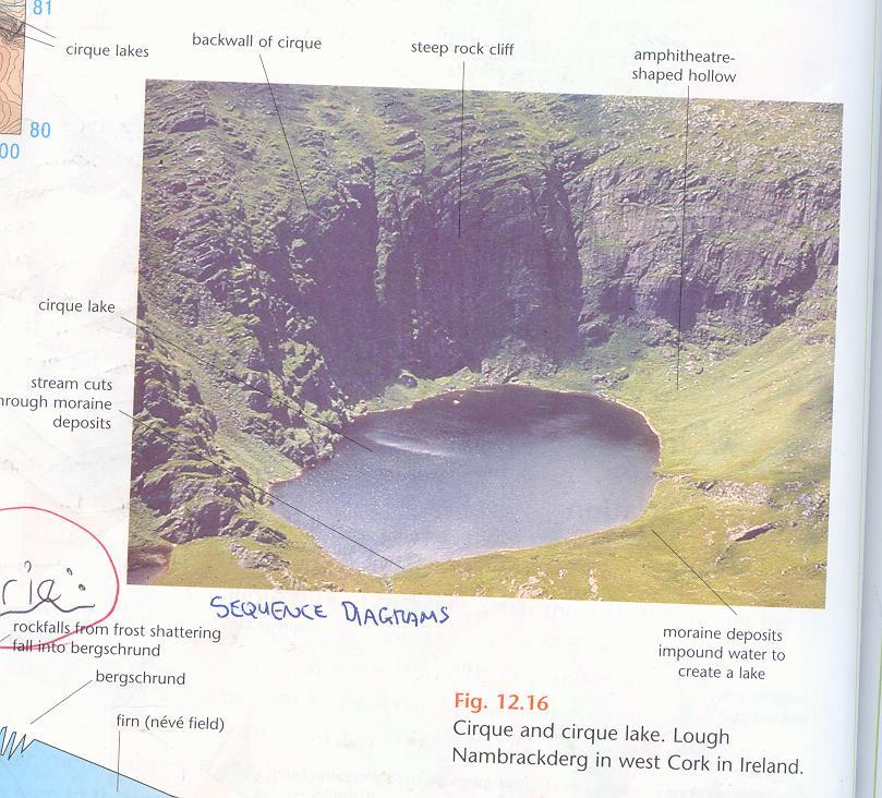
24 corrie

25 Steep back wall CORRIE Arete

26 U Shaped Valley look for river valley in or between mountains no contours along river side shows flat valley tightly packed contour lines along sides of valley shows steep sides made by eroding the interlocking spurs of the old river valley

27 Narrow u shaped valley with steep sides v.long ribbon lake

28 Some U shaped valleys can continue down onto lowlands so look for green colouring in valley any lakes found in valley even if no river occurs are RIBBON lakes

29 Steep sides Ribbon lakes
30 Drumlins are found on the Lowlands mainly in Cavan and Monaghan look for complete and rounded or nearly rounded contour lines the lines can have values to about 200m drumlins

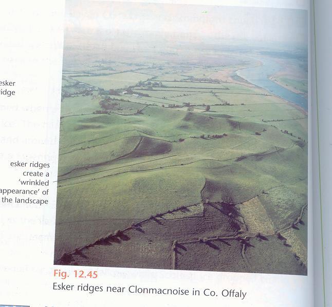
31 An ESKER ridge will be shown on the map as an elongated but closed contour line. This can follow a road or just exist on the landscape. It is usually just ONE contour line. Esker ridge
32 esker
33 Esker
34 Esker

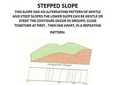
35 Kettleholes will be found in Wexford and Waterford the landscape around them will have very irregular contour lines and they will be little lakes dotted on the landscape. Kettle holes
 and it has")

36 Meltwater Channels if a river or road exists on the lowlands (green shading) and it has tightly packed contour lines on either side, you can state that it is a meltwater channel
37
38
39
40 AREA OF MAP ======= LENGTH x BY BREADTH AREA OF SEA ===== COUNT ALL FULL BLUE BOXES, COUNT ALL BLUE BOXES GREATER THAN A HALF ADD BOTH TOTALS TOGETHER YOU MUST STATE YOUR ANSWER IN SQUARE KILOMETERS
41 REMEMBER HALF SCALE IS REPRESENTED AS 1: 100,000 IF YOU ARE ASKED TO DO SKETCH ON GRAPH PAPER, IT IS WORTH 2 MARKS IF YOU ARE NOT ASKED TO USE GRAPH PAPER, THEN YOU HAVE A CHOICE
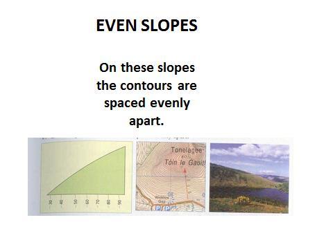
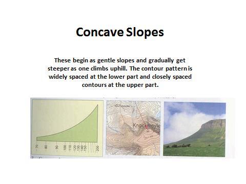
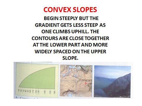
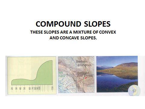
42 Do you remember the different types of slopes????
43
44
45
46
47
48

49


50 SKETCH FOR A 20 MARK QUESTION SHOULD BE DONE IN 8 MINUTES IF NOT ASKED FOR HALF SCALE THEN MAKE IT SMALLER THAN ORIGINAL Rules for sketch map PUT IN A TITLE AND THE SCALE ONLY DRAW IN THE THINGS ASKED FOR DRAW IN THE NORTH POINT AND THE SUBZONE LETTER If there is a large river or lake in the area, add it in even if not asked for it. MUST DRAW IN THE COASTLINE, EVEN IF NOT ASKED FOR. ALWAYS INCLUDE A KEY DRAW AND LABEL ON SKETCH


51 THERE ARE 3 MAIN TYPES OF SETTLEMENT --- LINEAR HOUSES IN A LINE DISPERSED HOUSES DOTTED ALL AROUND THE PLACE NUCLEATED --- HOUSES CLUSTERED TOGETHER
52 IF ASKED TO EXPLAIN THE DEVELOPMENT OF A TOWN OR CITY REMEMBER GO BACK IN TIME AND IMAGINE A LANDSCAPE OF 2,000 YEARS AGO WHAT WOULD HAVE ATTRACTED YOU TO STAY HERE???


53 RIVER LOOK AT IRISH NAME NODAL POINT LOOK AT ANTIQUITIES FOR CLUES TO WHO SETTLED HERE FLOOD PLAIN WIDE CONTOURS
1.5 Understand how ocean waves and currents change the face of coastal areas. (Chapter 3)
") 1.5 Understand how ocean waves and currents change the face of coastal areas. (Chapter 3) 1. Hydraulic Action/Pressure - air being forced into crack in rocks. 2. Corrosion (Solution) Minerals such as calcium
1.5 Understand how ocean waves and currents change the face of coastal areas. (Chapter 3) 1. Hydraulic Action/Pressure - air being forced into crack in rocks. 2. Corrosion (Solution) Minerals such as calcium
The Sea Geography Notes JC-Learn. JC-Learn. Geography Notes The Sea. 1 P a g e
 JC-Learn Geography Notes The Sea 1 P a g e The Sea *Here, you can choose to study the chapter on glaciation or the one on the sea, or even both, because whenever these topics come up in the Junior Cert
1.5 How do ocean waves and currents change the face of coastal areas? (Chapter 3)
") 1.5 How do ocean waves and currents change the face of coastal areas? (Chapter 3) 1. Hydraulic Action/Pressure - air being forced into crack in rocks. 2. Corrosion (Solution) Minerals such as calcium carbonate
1.5 How do ocean waves and currents change the face of coastal areas? (Chapter 3) 1. Hydraulic Action/Pressure - air being forced into crack in rocks. 2. Corrosion (Solution) Minerals such as calcium carbonate
Coastal Processes and Landforms
 Coastal Processes and Landforms These icons indicate that teacher s notes or useful web addresses are available in the Notes Page. This icon indicates that the slide contains activities created in Flash.
COASTAL SYSTEMS WAVE ENERGY
 WAVE ENERGY The energy of a wave determines its ability to erode and transport material on the coast Wave energy depends on the fetch, the distance the wind has blown the wave Wind strength and wind duration
General Coastal Notes + Landforms! 1
 General Coastal Notes + Landforms! 1 Types of Coastlines: Type Description Primary Coast which is essentially in the same condition when sea level stabilized Coastline after the last ice age, younger.
Coasts. 1. Coastal Processes. 1.1 Coastal erosion. 1.2 Sediment transport. Coastal Processes and Landforms. i. Hydraulic action
 Coasts Coastal Processes and Landforms 1. Coastal Processes 1.1 Coastal erosion i. Hydraulic action When waves strike against a rock surface, the waves trap air in the rock joints. This air is compressed
Earth Science Chapter 16 Section 3 Review
 Name: Class: Date: Earth Science Chapter 16 Section 3 Review Multiple Choice Identify the choice that best completes the statement or answers the question. 1. The movement of water that parallels the shore
Coastal Processes and Landforms
 Coastal Processes and Landforms These icons indicate that teacher s notes or useful web addresses are available in the Notes Page. This icon indicates that the slide contains activities created in Flash.
Chapter 10 Lecture Outline. The Restless Oceans
 Chapter 10 Lecture Outline The Restless Oceans Focus Question 10.1 How does the Coriolis effect influence ocean currents? The Ocean s Surface Circulation Ocean currents Masses of water that flow from one
page - Laboratory Exercise #5 Shoreline Processes
 page - Laboratory Exercise #5 Shoreline Processes Section A Shoreline Processes: Overview of Waves The ocean s surface is influenced by three types of motion (waves, tides and surface currents). Shorelines
Montessori for Everyone 2013 Types of Coastlines
 Coast The coast is the part of the land that borders the sea. It is subject to constant change, as the result of the waves and deposits carried by water onto the land. Coastline The coastline is where
There are many different kinds of beaches which are generally characterized by the dominance of waves, tides, rivers and currents, and in particular
 Fig. 11-11, p. 253 There are many different kinds of beaches which are generally characterized by the dominance of waves, tides, rivers and currents, and in particular differ by the amount of energy, which
Shore - place where ocean meets land Coast - refers to the larger zone affected by the processes that occur at this boundary.
 Waves, Beaches, and Coasts Shore - place where ocean meets land Coast - refers to the larger zone affected by the processes that occur at this boundary. Waves: energy moving through water The height of
Label the diagram below with long fetch and short fetch:
 Coastal Processes Coasts are shaped by the sea and the action of waves. The processes that take place are erosion, transportation and deposition. The power of waves is one of the most significant forces
/50. Physical Geology Shorelines
 Physical Geology Shorelines Multiple Guess: (You know the drill 2 points each) 1. The path of movement of a water particle in a wave at sea is 1. circular 2. horizontal 3. vertical 4. elliptical 5. none
Identify one factor which influences wave strength (1 Mark) Factors which affect wave strength
 Factors which affect wave strength") Coasts revision Identify one factor which influences wave strength (1 Mark) Factors which affect wave strength Identify one factor which influences wave strength (1 Mark) Factors which affect wave strength
Coasts revision Identify one factor which influences wave strength (1 Mark) Factors which affect wave strength Identify one factor which influences wave strength (1 Mark) Factors which affect wave strength
Nearshore Sediment Transport What influences the loss of sediment on Beaches? - Waves - Winds - Tidal Currents - River discharge - Runoff
 Tides & Beaches Nearshore Sediment Transport What influences the loss of sediment on Beaches? - Waves - Winds - Tidal Currents - River discharge - Runoff Oceans Ocean Topography Physical Structure of the
Name: Form: 2.To know the difference between Constructive and Destructive wave # $
 Name: Form: Landforms and landscape processes: COASTS 1. To know what factors affect the strength of waves # $ 2.To know the difference between Constructive and Destructive wave # $ 3. To be able to draw
Chapter. The Dynamic Ocean
 Chapter The Dynamic Ocean An ocean current is the mass of ocean water that flows from one place to another. 16.1 The Composition of Seawater Surface Circulation Surface Currents Surface currents are movements
Chapter - Oceans and Coasts
 Chapter - Oceans and Coasts Discussion: What do oceans contribute to the environment of Earth? How do Earth s major systems relate to the oceans? Oceans and Coasts Oceans are important - Thermal regulation
Lecture Outlines PowerPoint. Chapter 15 Earth Science, 12e Tarbuck/Lutgens
 Lecture Outlines PowerPoint Chapter 15 Earth Science, 12e Tarbuck/Lutgens 2009 Pearson Prentice Hall This work is protected by United States copyright laws and is provided solely for the use of instructors
Chesil Beach, Dorset UK High energy, shingle coastline. Brighton Beach, Sussex UK Pebble beach
 Beaches: Depositional landform Extends from the highest high tide to the lowest low tide. Very important temporary store in coastal system. Accretion: sediment returning to the visible portion of a beach
Reading Material. Inshore oceanography, Anikouchine and Sternberg The World Ocean, Prentice-Hall
 Reading Material Inshore oceanography, Anikouchine and Sternberg The World Ocean, Prentice-Hall BEACH PROCESSES AND COASTAL ENVIRONMENTS COASTAL FEATURES Cross section Map view Terminology for Coastal
Oceans and Coasts. Chapter 18
 Oceans and Coasts Chapter 18 Exploring the oceans The ocean floor Sediments thicken and the age of the seafloor increases from ridge to shore The continental shelf off the northeast United States Constituent
COASTS (P.38-45) Management: Hard engineering: Groynes Sea walls Gabions Soft Engineering: Beach replenishment Dune regeneration
 Management: Hard engineering: Groynes Sea walls Gabions Soft Engineering: Beach replenishment Dune regeneration") COASTS (P.38-45) Processes: Types of wave Weathering Mass Movement Erosion Transport Deposition Landforms: Cracks Caves Arches Stacks/stumps Headlands/bays Coves Spits Tombolos Beaches Sand dunes Management:
COASTS (P.38-45) Processes: Types of wave Weathering Mass Movement Erosion Transport Deposition Landforms: Cracks Caves Arches Stacks/stumps Headlands/bays Coves Spits Tombolos Beaches Sand dunes Management:
Shorelines Earth - Chapter 20 Stan Hatfield Southwestern Illinois College
 Shorelines Earth - Chapter 20 Stan Hatfield Southwestern Illinois College The Shoreline A Dynamic Interface The shoreline is a dynamic interface (common boundary) among air, land, and the ocean. The shoreline
Overview. Beach Features. Coastal Regions. Other Beach Profile Features. CHAPTER 10 The Coast: Beaches and Shoreline Processes.
 Overview CHAPTER 10 The Coast: Beaches and Shoreline Processes Coastal regions constantly change. The beach is a dominant coastal feature. Wave activity continually modifies the beach and coastal areas.
Chapter 20 Lecture. Earth: An Introduction to Physical Geology. Eleventh Edition. Shorelines. Tarbuck and Lutgens Pearson Education, Inc.
 Chapter 20 Lecture Earth: An Introduction to Physical Geology Eleventh Edition Shorelines Tarbuck and Lutgens The Shoreline: A Dynamic Interface The Coastal Zone The shoreline is constantly modified by
TITLE: COASTAL EROSION AND LANDFORMS.
 TITLE: COASTAL EROSION AND LANDFORMS. AIM: What are the factors that influence the formation of coastal features along Fishing Pond beach Trinidad? LOCATION OF FIELD STUDY: The study was carried out in
Coastal management has lagged behind the growth in population leading to problems with pollution
 Fifty percent of the population of the industrialized world lives within 100 km of a coast. Coastal management has lagged behind the growth in population leading to problems with pollution and natural
Essentials of Oceanography Eleventh Edition
 Chapter Chapter 1 10 Clickers Lecture Essentials of Oceanography Eleventh Edition The Coast: Beaches and Shoreline Processes Alan P. Trujillo Harold V. Thurman Chapter Overview Coastal regions have distinct
Marginal Marine Environments
 Marginal Marine Environments Delta: discrete shoreline protuberances formed where rivers enter oceans, semi-enclosed seas, lakes or lagoons and supply sediment more rapidly than it can be redistributed
Coastal Change and Conflict
 Coastal Change and Conflict Outline of the Topic Contrasting Coasts why do all coasts not look the same? Geology of the coast the impact rock structure has on the coastline Waves Constructive and destructive
1 Shoreline Erosion and Deposition
 CHAPTER 12 1 Shoreline Erosion and Deposition SECTION Agents of Erosion and Deposition BEFORE YOU READ After you read this section, you should be able to answer these questions: What is a shoreline? How
Shorelines Earth Chapter 20 Chapter 20 Shorelines The Shoreline: A Dynamic Interface Cape Cod and Point Reyes Hurricane Sandy
 1 2 3 4 5 6 7 8 9 10 11 12 13 Shorelines Earth Chapter 20 Chapter 20 Shorelines The Shoreline: A Dynamic Interface The interface is the common boundary where different parts of a system interact. The Coastal
1 Shoreline Erosion and Deposition
 CHAPTER 12 1 Shoreline Erosion and Deposition SECTION Agents of Erosion and Deposition BEFORE YOU READ After you read this section, you should be able to answer these questions: What is a shoreline? How
Apostle Islands National Seashore
 Apostle Islands National Seashore David Speer & Phillip Larson October 2 nd Fieldtrip Report Table of Contents Introduction 1 Stop 1: Apostle Island Boat Cruise 1 Stop 2: Coastal Geomorphology 5 Stop 3:
4/20/17. #30 - Coastlines - General Principles Coastlines - Overview
 Writing Assignment Due one week from today by 11:59 pm See main class web pages for detailed instructions Essays will be submitted in Illinois Compass (instructions later) Pick one: Earthquakes, tsunamis,
OECS Regional Engineering Workshop September 29 October 3, 2014
 B E A C H E S. M A R I N A S. D E S I G N. C O N S T R U C T I O N. OECS Regional Engineering Workshop September 29 October 3, 2014 Coastal Erosion and Sea Defense: Introduction to Coastal Dynamics David
Studland Bay Context and Learning Aims
 Studland Bay Enquiry 7: How are coastal processes affecting Studland Bay? Context and Learning Aims Pupils will be supported in and outside of the classroom to: Identify; describe and explain the physical
Imagine that you can see a side view of a wave as it approaches a beach. Describe how the wave changes as the wave approaches the beach.
 Geology 101 Name Reading Guide for Ch. 19: Shores and Coastal Processes (p. 612) Waves, Currents, and Tides (p. 614) Waves and Currents (p. 614) Imagine that you can see a side view of a wave as it approaches
GCSE GEOGARPHY OCR B REVISION GUIDE Coasts
 GCSE GEOGARPHY OCR B REVISION GUIDE Coasts Definition: The interface between land and sea. Coastal regions cover only 10% of the inhabited land space, yet they are home to more than 60% of the world s
Site The fieldwork should be completed at a localised site on the Victorian coast (or elsewhere).
.") Coastal fieldwork Studying the coast provides the opportunity to conduct fieldwork in coastal regions. This fieldwork could investigate the geographic characteristics of the coast and how they change over
Coastal fieldwork Studying the coast provides the opportunity to conduct fieldwork in coastal regions. This fieldwork could investigate the geographic characteristics of the coast and how they change over
The Physical and Human Causes of Erosion. The Holderness Coast
 The Physical and Human Causes of Erosion The Holderness Coast By The British Geographer Situation The Holderness coast is located on the east coast of England and is part of the East Riding of Yorkshire;
Formation and characteristics of different types of beaches
 Activity Title: Formation and characteristics of different types of beaches Focusing questions What different types of beaches are there in New Zealand? How are estuaries different to open coastal sandy
Site: London Bridge. Some further information about London Bridge can be found at the Parks Victoria website
 Site: London Bridge About London Bridge London Bridge is located at the Portsea Back Beach which is approximately 3 kilometres south of Portsea. This site provides students with excellent examples of coastal
WHAT ARE THE MAJOR COASTLINE FEATURES AND WAVE CHARACTERISTICS WHICH INDICATE THAT MARINE EROSION IS ACTIVE ON THE EASTERN SIDE OF THE
 WHAT ARE THE MAJOR COASTLINE FEATURES AND WAVE CHARACTERISTICS WHICH INDICATE THAT MARINE EROSION IS ACTIVE ON THE EASTERN SIDE OF THE ENTRANCE TO DISCOVERY BAY HARBOUR IN JAMAICA? JEFFREY JOHNSON YORK
Natural Bridges Field Trip Activity
 Natural Bridges Field Trip Activity This is due in class on MONDAY- March 1 - not in sections! Name TA: NOTE ON THE GRADING OF THIS ASSIGNMENT: Many of the questions below (especially in the tidepool part)
Constructive waves build beaches. Each wave is low. As the wave breaks it carries material up the beach in its. material will then be deposited as
 Constructive waves Constructive waves build beaches. Each wave is low. As the wave breaks it carries material up the beach in its swash. The beach material will then be deposited as the backwash soaks
COASTAL ENVIRONMENTS. 454 lecture 12
 COASTAL ENVIRONMENTS Repeated movement of sediment & water constructs a beach profile reflecting the balance between average daily or seasonal wave forces and resistance of landmass to wave action Coasts
Chapter 12: Coasts (after a brief review of Tides)
") Chapter 12: Coasts (after a brief review of Tides) 1 Questions from previous classes: What happens when a wave meets a current? wave = people walking current = bus If wave goes with the current, the wave
Chapter 12: Coasts (after a brief review of Tides) 1 Questions from previous classes: What happens when a wave meets a current? wave = people walking current = bus If wave goes with the current, the wave
SUBJECT: EARTH SCIENCE PAPER: THE DYNAMIC EARTH. Code : 27 COASTAL PROCESSES AND LANDFORMS PROF. A. BALASUBRAMANIAN
 SUBJECT: EARTH SCIENCE PAPER: THE DYNAMIC EARTH Code : 27 TOPIC: COASTAL PROCESSES AND LANDFORMS BY PROF. A. BALASUBRAMANIAN Objectives After attending this module, the user would be able to understand
Läna i is a single shield that formed from summit eruptions and along
 Läna i is a single shield that formed from summit eruptions and along three rift zones between 1.2 and 1.46 Ma; a classic example of a Hawaiian shield with a gently sloping profile. The small sub-circular
Figure 4, Photo mosaic taken on February 14 about an hour before sunset near low tide.
 The Impact on Great South Bay of the Breach at Old Inlet Charles N. Flagg and Roger Flood School of Marine and Atmospheric Sciences, Stony Brook University Since the last report was issued on January 31
NAME: DATE: Geography: Sea Action. Geography. Sea Action
 Geography Sea Action It is not necessary to carry out all the activities contained in this unit. Please see Teachers Notes for explanations, additional activities, and tips and suggestions. Theme All students:
BEACH PROCESSES AND COASTAL ENVIRONMENTS
 BEACH PROCESSES AND COASTAL ENVIRONMENTS COASTAL FEATURES Cross section Map view TOPICS: Terminology Waves Beach Morphology Barriers Coastal Migration Tides Tidal Flats and Marshes Sediment Budgets Human
Requirements: You will need to bring your laptop with Google Earth and Jtides loaded and ready to go. See Appendix
 Morphological Classification of Shorelines based on Hydrographic Regime Dr. Lindley Hanson, Dept. Geological Sciences Salem State College (lhanson@salemstate.edu) Key Concepts: hydrographic regime, morphological
Ocean Waves. Capillary. Gravity. Wind generated. Tides Tsunamis Seiches
 Ocean Waves Capillary Wind generated Gravity Tides Tsunamis Seiches Capillary waves are driven by the surface tension produced by electrically polarized water molecule San Pedro Lighthouse Waves are alternate
LAB: WHERE S THE BEACH
 Name: LAB: WHERE S THE BEACH Introduction When you build a sandcastle on the beach, you don't expect it to last forever. You spread out your towel to sunbathe, but you know you can't stay in the same spot
Beaches Unit (4.5 pts)
") T. James Noyes, El Camino College Beaches Unit (Topic 6A) page 1 Name: Section: Beaches Unit (4.5 pts) Beaches and Shorelines Are Always Changing Waves are slowly and inexorably altering the shoreline,
T. James Noyes, El Camino College Beaches Unit (Topic 6A) page 1 Name: Section: Beaches Unit (4.5 pts) Beaches and Shorelines Are Always Changing Waves are slowly and inexorably altering the shoreline,
Map 8: Ayrshire Coast: Ardrossan North Bay to Stevenston Pier Map Content Descriptions
 Map 8: Ayrshire Coast: Ardrossan North Bay to Stevenston Pier Map Content Descriptions 1. Built Heritage and Archaeology A total of twenty four sites were recorded in the area covered by Map 8. Of these
Work Sample. Terry INTRODUCTION
 INTRODUCTION As an environmental consultant, I will be conducting an investigation into the effectiveness of the coastal management strategies currently being undertaken at XXX beach. Here I will be looking
Figure 1. Schematic illustration of the major environments on Mustang Island.
 STOP #1: PACKERY CHANNEL BEACH TO BAY We will start this field guide near the north jetty of Packery Channel and hike across the island to Corpus Christi Bay (fig. 1). The island emerges from the Gulf
Australian Coastal Councils Conference
 Australian Coastal Councils Conference Kiama March 2019 Where Has My Beach Gone? (and what can I do about it?) Dr Andrew McCowan Water Technology Where Has My Beach Gone? Where Has My Beach Gone? Where
Estuaries: Life on the Interface
 Material adapted from: Estuaries: Interface between sea and land & Sea Margin Diversity, The Water Sourcebook Grades 9-12, EPA http://www.epa.gov/safewater/kids/wsb/ Introduction: Some of the most dynamic
Waves- how are they formed and how do they affect the coast?
 Question 7 Coasts Waves- how are they formed and how do they affect the coast? Waves are caused by friction between the wind and water causing the water to swell. The size and energy of a wave is influenced
CHAPTER 8 ASSESSMENT OF COASTAL VULNERABILITY INDEX
 124 CHAPTER 8 ASSESSMENT OF COASTAL VULNERABILITY INDEX 8.1 INTRODUCTION In order to assess the vulnerability of the shoreline considered under this study against the changing environmental conditions,
Analyses of Amelander Nourishments. Sander van Rooij
 Analyses of Amelander Nourishments Sander van Rooij Deltares, 2008 Prepared for: Kustlijnzorg Analyses of Amelander Nourishments Sander van Rooij Report December 2008 Z4582.12 Client Kustlijnzorg Title
Environmental Geology Chapter 11 COASTAL PROCESSES and RELATED HAZARDS
 Environmental Geology Chapter 11 COASTAL PROCESSES and RELATED HAZARDS Introduction >50% of world population concentrated in the coastal zones ~75% of U.S. population living in coastal states Coastal hazard
1.1 Coastal processes produce landforms
 1.1 Coastal processes produce landforms Types of wave: destructive and constructive Destructive Carry out erosion Tall Powerful High frequency Backwash greater than the swash Take sediment from beach to
Coastal Processes Day Criccieth
 Coastal Processes Rivers (Conwy) Rivers (Peris) Urban Studies Lowland Glaciation Tourism and National Parks Soils Sand Dunes Upland Glaciation Rural Settlements The Centre and Staff Fieldwork Equipment
Why Study Shorelines?
 Why Study Shorelines? The seafloor is the largest part of Earth s surface. Many seafloor features and processes provide evidence of plate tectonics. Seafloor sediments and rocks are a source of several
The Composition of Seawater
 The Composition of Seawater Salinity Salinity is the total amount of solid material dissolved in water. Most of the salt in seawater is sodium chloride, common table salt. Element Percent Element Percent
Ch 9: Waves. Wind waves. Formation of a wind wave
 Ch 9: Waves 1. Features of Waves 2. Deep-water, shallow water and transitional waves 3. Breaking Waves 4. Wind Waves 5. Tsunamis Cf. Fig. 9-2 Waves are created by a disturbance. * wind (wind waves, L=
Estuarine Shoreline Stabilization
 Estuarine Shoreline Stabilization Property Owner s Guide to Determining the Most Appropriate Stabilization Method Estuarine shorelines are dynamic features that experience continued erosion. Land is lost
Define the key terms: - Abrasion - Attrition - Hydraulic action - Solution. Y11 Coasts
 Define the key terms: - Abrasion - Attrition - Hydraulic action - Solution Abrasion caused by waves picking up material which is forced against the cliff face wearing it away Attrition where stones and
Draw a picture of a water source. Don t forget to include yourself in the picture!
 Name Date Draw a picture of a water source. Don t forget to include yourself in the picture! My water source is Students describe the characteristics of a water source: stream, river, lake, pond, ocean,
Wattamolla to Big Marley Beach
 Wattamolla to Big Marley Beach 4 hrs 10.4 km Circuit Moderate track 4m This walk is an excellent loop which takes in both the coast and the heathy inland of Royal National Park. Nearly the whole walk has
Dynamic Shoreline. Why do we care? Loss of land Damage to structures Recreation
 Dynamic Shoreline Why do we care? Loss of land Damage to structures Recreation Coastal Water Movement Waves provide the energy Through breaking As waves shoal Speed decreases Height increases Wavelength
Questions # 4 7 refer to Figure # 2 (page 321, Fig )
") Shoreline Community College OCEANOGRAPHY 101 Fall 2006 Sample Exam # 3 Instructor: Linda Khandro Questions # 1 3 refer to Figure # 1 (page 284, Fig 11.7) 1. At which position is the moon in its new moon
Shoreline Community College OCEANOGRAPHY 101 Fall 2006 Sample Exam # 3 Instructor: Linda Khandro Questions # 1 3 refer to Figure # 1 (page 284, Fig 11.7) 1. At which position is the moon in its new moon
Inner-Bank Erosion Processes and Solutions at Coastal Inlets
 Inner-Bank Erosion Processes and Solutions at Coastal Inlets by William C. Seabergh PURPOSE: The Coastal and Hydraulics Engineering Technical Note (CHETN) herein provides information on erosion which occurs
Geography of the Lower Fitzroy and navigation problems
 Geography of the Lower Fitzroy and navigation problems A topographic map of the Fitzroy estuary readily indicates why the Fitzroy River has proved difficult for shipping to negotiate. The river meanders
GEOLOGY 101 Under the Boardwalk: Coastal Geomorphology
 GEOLOGY 101 Under the Boardwalk: Coastal Geomorphology What to look for while you're on the beach during spring break. J.S. Kite, WVU What Causes Changes in Sea Level? Answer Varies with Time Scale. Long-Term
Coastal Zones. Coastal Zones
 Page 1 of 15 EENS 3050 Tulane University Natural Disasters Prof. Stephen A. Nelson Coastal Zones Coastal Zones A coastal zone is the interface between the land and water. These zones are important because
Texas passes, longshore transport, hurricanes, beach erosion and sea level
 Texas passes, longshore transport, hurricanes, beach erosion and sea level Richard L. Watson, Ph.D. (361) 749-4152 Field work can be strange! 120,000 years of sea level Years each zone exposed above S/L
Beach Profiles: Monitoring Sea Level Rise. Student Activity Sheet. Name Date Class
 Beach Profiles: Monitoring Sea Level Rise Student Activity Sheet Name Date Class A shoreline is the area where the water and land meet. This is where we find beach: areas where sediments (sand or other
Monterey Peninsula College
 Introduction to Google Earth Name Goals 1. To become proficient at using the basic features of Google Earth. 2. To recognize differences in coastal features between the east and west coast of North America.
Section 1: Waves. There are two distinct types of wave at the coastline: constructive and destructive waves.
 Coastal Erosion EARTH SCIENCE GEOLOGY COASTAL EROSION Section 1: Waves How do waves form? Waves are generated by the competing forces of surface friction. The wind transfers energy from air to water and
Impacts of breakwaters and training walls
 Across the eastern seaboard of Australia, breakwaters and training walls have instigated fundamental perturbations to coastal and estuary processes. This has induced long-term changes to foreshore alignments,
Beach profile surveys and morphological change, Otago Harbour entrance to Karitane May 2014 to June 2015
 Beach profile surveys and morphological change, Otago Harbour entrance to Karitane May 2014 to June 2015 Prepared for Port Otago Ltd Martin Single September 2015 Shore Processes and Management Ltd Contact
Deep-water orbital waves
 What happens when waves approach shore? Deep-water orbital waves Fig. 9.16, p. 211 Wave motion is influenced by water depth and shape of the shoreline wave buildup zone surf zone beach Wave base deepwater
Under the Boardwalk: Coastal Geomorphology
 Under the Boardwalk: Coastal Geomorphology What to look for while you're on the beach during spring break. What Causes Changes in Sea Level? Answer Varies with Time Scale. Long-Term Changes in Sea Level
Proceedings, 2001National Conference on Beach Preservation Technology, pp COASTAL INLET BANK EROSION. William C.
 Proceedings, 2001National Conference on Beach Preservation Technology, pp. 274-283 COASTAL INLET BANK EROSION William C. Seabergh 1 Abstract: Much focus is placed on beach erosion on the open coast. However,
Campbell Drive to Snapper Point
 Campbell Drive to Snapper Point 1 hr 45 mins 4.2 km One way Experienced only 135m This walk follows the Coast Track to Frazer Beach, along the Geebung and (overgrown) Grass Tree Tracks. From the northern
UPPER BEACH REPLENISHMENT PROJECT RELATED
 ASSESSMENT OF SAND VOLUME LOSS at the TOWNSHIP of UPPER BEACH REPLENISHMENT PROJECT RELATED to the LANDFALL OF HURRICANE SANDY - PURSUANT TO NJ-DR 4086 This assessment is in response to Hurricane Sandy
COASTAL MANAGEMENT AND PROTECTION METHODS! 1
 COASTAL MANAGEMENT AND PROTECTION METHODS! 1 Strategy What it does Cons Pros Examples SOFT ENGINEERING: The use of ecological principles and practices to reduce erosion and achieve the stabilization and
Tidally influenced environments. By Alex Tkaczyk, Henrique Menezes, and Isaac Foli
 Tidally influenced environments By Alex Tkaczyk, Henrique Menezes, and Isaac Foli Goals and aims Describe the role of tidal influence in depositional environments. - Deltas - Estuaries Provide an overview
Chapter 15 SEASONAL CHANGES IN BEACHES OP THE NORTH ATLANTIC COAST OF THE UNITED STATES
 Chapter 15 SEASONAL CHANGES IN BEACHES OP THE NORTH ATLANTIC COAST OF THE UNITED STATES By John M. Darling Hydraulic Engineer, Research Division U. S. Army Coastal Engineering Research Center Corps of
The Impact on Great South Bay of the Breach at Old Inlet Charles N. Flagg School of Marine and Atmospheric Sciences, Stony Brook University
 The Impact on Great South Bay of the Breach at Old Inlet Charles N. Flagg School of Marine and Atmospheric Sciences, Stony Brook University This is the sixth in a series of reports describing the evolution