Tides. Tides: longest waves. or seas. or ripples
|
|
|
- Carmella Leonard
- 6 years ago
- Views:
Transcription
1 Tides or ripples or seas Tides: longest waves
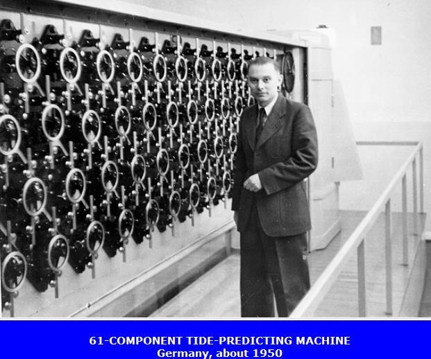
2 Tides Definition: The rise and fall of sea level due to the gravitational forces of the Moon and Sun and the rotation of the Earth. Why tides are important? - ship navigation in harbors - coastal morphology (sediments motion) - tidal currents impact ocean mixing - fishing, marine biology, etc. How to predict tides? - mechanical tide calculating machines since 1880s, tidal charts and analysis - computer models, tide gauges, satellite altimetry, etc. Largest tides: 17m range: Bay of Fundy & Ungava Bay (Canada); ~10m: Cook Inlet (Alaska) Simulated & observed tides, Cook Inlet, Alaska


3 Tide measurements old mechanical recorder satellite transmitter acoustic sensor solar panel today s tide and meteorological station old mechanical float electronics box
4

5


6 Useful resources for tidal data: NOAA Tides Online

7 Global Tide Gauge Data (longest records ~200 years; PSMSL used mostly for studies of sea level rise)


8 (Physics Today, 2011)
9

10 Tides are important for fishermen Note that while weather can only be predicted for a few days, because of the cyclical nature of tides, they can be predicted many days and years in advance

11 Tidal charts and ship navigation (Cairns Harbour, Australia)

12 NOS/NOAA education

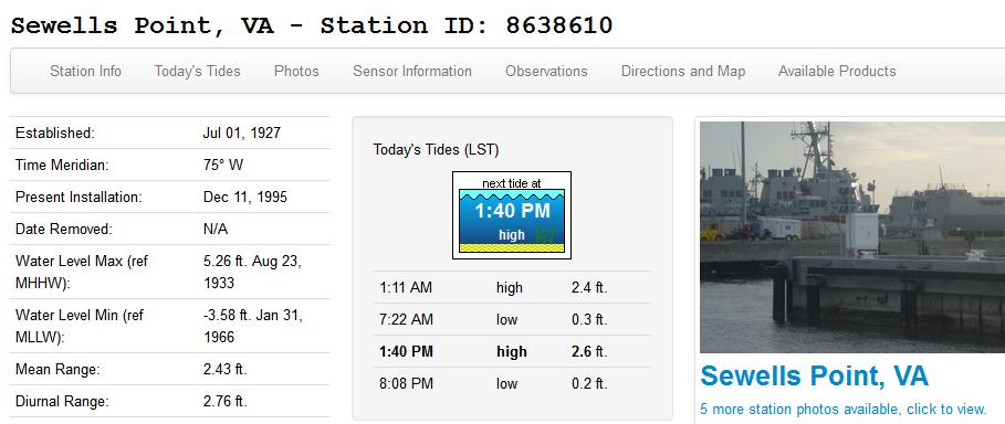
13 Berkley Bridge over the Elizabeth River (picture by T. Ezer, Nov-2017)
 (intertidal) covered/ exposed with the tidal cycle Deep ocean always covered by")
14 Neap tide range Spring tide range Tides are important for biological zonation along the shore shore (supratidal) never covered by water (maybe splash from waves) (intertidal) covered/ exposed with the tidal cycle Deep ocean always covered by water


15 Elizabeth River Low Tide High Tide (pictures by T. Ezer, Nov-2017)
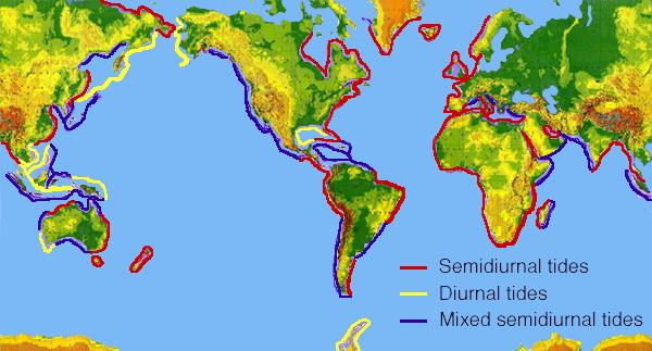
16 Tidal Terminology Spring tide- (from old English Springere- to rise, not season) high tide range when sun and moon are inline at full or new moon. MHWS : Mean High Water Spring MLWS : Mean Low Water Spring Neap tide- (Near Even As Possible) low tide range when moon & sun effect cancel each other MHWN : Mean High Water Neap MLWN : Mean Low Water Neap MSL : Mean Sea Level (need a reference level) Semi-diurnal Tide- The most common tidal pattern, featuring two highs and two lows each day Diurnal Tide- Only a single high and a single low during each tidal day Flood- The tidal current when it is coming from the sea to the shore Ebb- The tidal current when it is coming from shore and returning to the sea Slack- The point between flood and ebb (or ebb and flood) currents when there is no flow.
17 Tidal Range Tidal Amplitude Why we have these different tides? Later
18 The relation between tidal water level ( ) and tidal current (u) Tide water level can be described by: A = tidal amplitude (tidal range=2a) = tidal frequency = tidal phase A u max & max u are out of phase Low Tide Slack wat er before flood Flood T ide ( t) High T ide Slack wat er after flood Acos t f Ebb T ide u( t) U cos t 2 f t t
 Centrifugal")

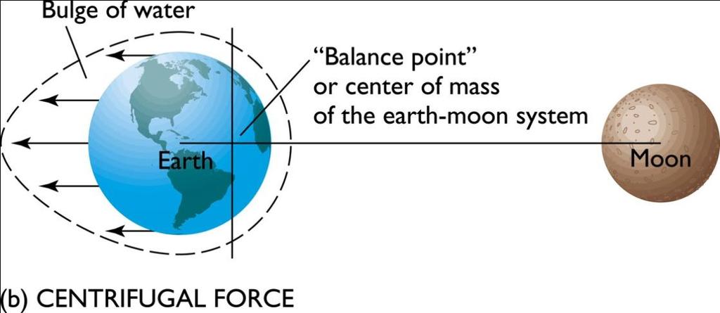
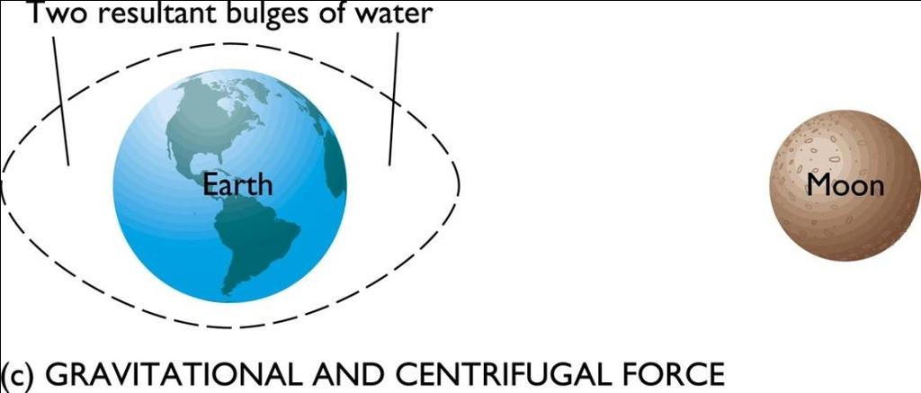
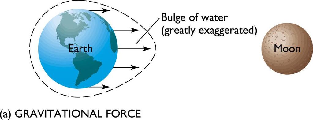
19 What are the physical forces of tides? Earth EQUILIBRIUM TIDE Moon The forces between two moving bodies (Moon & Earth) Centrifugal forces: push bodies away from each other Gravitational forces: push bodies toward each other- stronger on the side facing the moon The difference between the two forces is uneven over the earth generate tides (if forces are in equilibrium)
20 F a F c Balance of forces: gravitational attraction at a centrifugal force at a Gravitational Constant G = N m 2 /kg 2 2 mm mm 2PR R G G ( GmM) ( P R) P P 2P R P R 2 F Since the Moon is relatively far compared to Earth s radius, P>>R a F c 2R ( GmM) ; 3 P F b F c 2R ( GmM) 3 P m P=distance between center of Earth and center of Moon R= radius of Earth Since F~M/P 3, effect of Sun vs. Moon: M M sun =2.5x10 7 M moon ; P sun =400P moon F sun ~ (2.5x10 7 )/(400) 3 F moon ~ 0.4F moon Tides in average: 60% moon and 40% sun
21 EQUILIBRIUM TIDE
22 Why tides are different at different latitudes? Declination (tilt) angle between the moon and earth axis. However, the combined effects of lunar and solar, diurnal and semidiurnal is more complex in the real ocean
23
24
25
![F=0.1 a useful way to characterize the tide is: The Form factor F = [ K 1 + O 1 ] / [ M 2 + S 2 ] F < 0.25 the tide is semidiurnal F=0.9 0.](/docs-images/72/66273160/images/26-0.jpg "25 < F < 1.25 the tide is mixed - mainly semidiurnal F=2.1 1.25 < F < 3.")
26 F=0.1 a useful way to characterize the tide is: The Form factor F = [ K 1 + O 1 ] / [ M 2 + S 2 ] F < 0.25 the tide is semidiurnal F= < F < 1.25 the tide is mixed - mainly semidiurnal F= < F < 3.00 the tide is mixed - mainly diurnal F=19 F > 3 the tide is diurnal
27 Equilibrium vs. Dynamic theories of tides Equilibrium theory of tides: If the entire globe is covered with water and we sum up the forces along the surface, the maximum Spring Tide when the Moon & Sun are in line would be always 55cm (M)+24cm(S)=79cm However, in reality tides in different places are very different! Dynamic theory of tides: shallow-water waves driven by periodic forcing- amplified when basin in resonant with dominant periods, affected by coastline topography and Coriolis. Actual tides in Chesapeake Bay
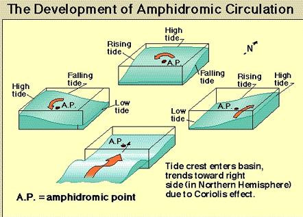
28 y The tide propagation involve both, progressive free waves in the open ocean and waves running along coasts (mostly Kelvin Waves): - long waves that travel parallel to the coastline - geostrophic balance with higher sea level near the coast - in N. Hemisphere generate counterclockwise propagation Coriolis Pressure Gradient x ( x, y, t) 0 cos( ky t) wave propagates in y-direction fx gh e sea-lev decays in x-direction
29
 Amphidromic point Tidal propagation (anti-clockwise in N.")
30 Semidiurnal tide in the North Sea ( Amphidromic System ) Co-tidal lines: points with the same tidal stage (phase) Co-range lines: points with the same tidal range (amplitude) Amphidromic point Tidal propagation (anti-clockwise in N. Hemisphere)
 An")
 The amphidromic system for the Gulf of")
31 Tidal Patterns Vary with Ocean Basin Shape and Size: shallow-wide basin (a) An amphidromic system in a broad, shallow basin. (b) The amphidromic system for the Gulf of St. Lawrence
 True amphidromic systems do not develop")
 Tides in the Bay of Fundy, Nova Scotia (one of the")
32 Tidal Patterns Vary with Ocean Basin Shape and Size: narrow basin (a) True amphidromic systems do not develop in narrow basins because there is no space for rotation. (b) Tides in the Bay of Fundy, Nova Scotia (one of the largest tides)
33 For shallow water: How can tides be predicted? Most common: Harmonic Method Use long-term tide gauge data Do harmonic analysis of basic tidal constituents (i.e., find the amplitude and phase of each component) Use astronomical tables or tidal calculators for future tides at each location ( t) M 2 1 A1 sin( 1t 1) A2 sin( 2t 2)... K


34 Useful resources for tidal data: NOAA Tides Online
35 (Data:
36 Why are the predicted and observed tides different?
37 How well can we predict tides? What about wind-driven (storm surge) variations? November-09 Nor Easter Water Level: Tides+ storm surge Tides only Wind:


 Major")

38 Floods in Hague area (Nowbray St., Norfolk, VA) Minor flood: high tide (~4ft; ) Major flood: Hurricane Sandy (~7ft; )

39 useful tools for global tide prediction: TPXO6.2 Load Tide: Global Inverse Tide Model 1/4 x1/4 developed at Oregon State University, based on assimilation of T/P altimetry with corrections for coastal oceans. (code available in Fortran and Matlab) M2 Run Matlab Tide
 (Oey &")
 H=50m depth; L=250km long C=(gH) ½ = 22 m/s")
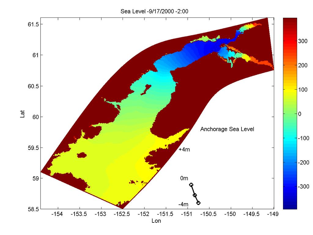
40 Model simulations in Cook Inlet, Alaska, where the inlet size creates a perfect resonant with the tidal period (M 2 ) (Oey & Ezer et al., 2007) H=50m depth; L=250km long C=(gH) ½ = 22 m/s propagation speed Resonant: T=4L/C = ~12h (M 2 period=12.42h)
41
42 The amplification of the tides in the inlet are simulated quite well Anchorage Nikiski Seldovia Kodiak Island mod obs
 2m high, 3-5 m/s propagation")
43 Tidal Bores over the mud flats in Turnagain Arm of Cook Inlet: big tourist attraction (and a challenge for surfers ) 2m high, 3-5 m/s propagation speed

44 flood m/s Velocity and tide level in Turnagain Arm ebb


45 Low Tide Cook Inlet, Alaska High Tide

46 Bay of Fundy: Max. Spring Tide: 17 m Shape of basin Oscillation period close to tidal period Shoals and narrows to north Basin oriented toward right (Coriolis moves water toward right)
47 finished with waves and tides Next Classes: Tuesday 21-November: Coastal processes I (homework#5 due) Thursday 23-November: Happy Thanksgiving Tuesday 28-November: Coastal processes II Thursday 30-November: Estuaries and models Tuesday 5-December: Review for exam Thursday 07-December: Exam#3
Chapter 11 Tides. A tidal bore is formed when a tide arrives to an enclosed river mouth. This is a forced wave that breaks.
 Chapter 11 Tides A tidal bore is formed when a tide arrives to an enclosed river mouth. This is a forced wave that breaks. Tidal range can be very large Tide - rhythmic oscillation of the ocean surface
Theory and Application Introductory Oceanography Ray Rector: Instructor
 OCEAN TIDES Theory and Application Introductory Oceanography Ray Rector: Instructor Tidal Concepts Tides are extremely swift, very long-wavelength, shallow-water waves Tides are periodic short-term changes
TIDES. Theory and Application
 TIDES Theory and Application Tidal Concepts Tides are extremely swift, very long-wavelength, shallow-water waves Tides are periodic short-term changes in sea level at a particular place caused by the gravitational
SURFACE CURRENTS AND TIDES
 NAME SURFACE CURRENTS AND TIDES I. Origin of surface currents Surface currents arise due to the interaction of the prevailing wis a the ocean surface. Hence the surface wi pattern (Figure 1) plays a key
MAR 110 LECTURE #16 Tides
 MAR 110: Lecture 16 Outline Tides 1 MAR 110 LECTURE #16 Tides Tides Are Waves Tidal wave energy is concentrated at periods of approximately 12 and 24 hours. (ItO) Equilibrium Tidal Forcing The theoretical
MAR 555 Lecture 20: Coastal Tides
 MAR 555 Lecture 20: Coastal Tides Tides caused by the resulting gravitational and centrifugal forces is called equilibrium tide. They can be expressed using the harmonic functions as N semi! e(semi) =
OCN 201 Tides. Tsunamis, Tides and other long waves
 OCN 201 Tides Tsunamis, Tides and other long waves Storm surges Caused by winds and low atmospheric pressure associated with large storms Can raise sea surface by up to 25 ft, bottom contours magnify effect
Equilibrium Model of Tides
 Tides Outline Equilibrium Theory of Tides diurnal, semidiurnal and mixed semidiurnal tides spring and neap tides Dynamic Theory of Tides rotary tidal motion larger tidal ranges in coastal versus open-ocean
Announcements. Project 2 due Nov 7 th Topics for today: Big waves. Tsunamis, seiches and tidal waves. Tsunamis and seiches
 Announcements Project 2 due Nov 7 th Topics for today: Big waves Tsunamis, seiches and tidal waves Tsunamis and seiches Seiche: standing wave that rocks back and forth within an enclosed or semi-enclosed
MAR 110 LECTURE #22 Standing Waves and Tides
 27 October 2007 MAR110_Lec22_standing Waves_tides_27oct07.doc 1 MAR 110 LECTURE #22 Standing Waves and Tides Coastal Zone Beach Profile Figure 22.1 Beach Profile Summer Onshore Sand Transport Breaking
The ocean water is dynamic. Its physical
 CHAPTER MOVEMENTS OF OCEAN WATER The ocean water is dynamic. Its physical characteristics like temperature, salinity, density and the external forces like of the sun, moon and the winds influence the movement
Overview and preview. I. Tides as Waves (really really big) What are the Forces driving these waves? II: Into make-believe.
 What are the Forces driving these waves? II: Into make-believe.") The Tides Overview and preview I. Tides as Waves (really really big) What are the Forces driving these waves? II: Into make-believe. Idealized world: no land, deep water, no friction.no problems. Effects
The Tides Overview and preview I. Tides as Waves (really really big) What are the Forces driving these waves? II: Into make-believe. Idealized world: no land, deep water, no friction.no problems. Effects
Appendix 5: Currents in Minas Basin. (Oceans Ltd. 2009)
") Appendix 5: Currents in Minas Basin (Oceans Ltd. 29) Current in Minas Basin May 1, 28 March 29, 29 Submitted To: Minas Basin Pulp and Power P.O. Box 41 53 Prince Street Hansport, NS, BP 1P by 22, Purdy
Appendix 5: Currents in Minas Basin (Oceans Ltd. 29) Current in Minas Basin May 1, 28 March 29, 29 Submitted To: Minas Basin Pulp and Power P.O. Box 41 53 Prince Street Hansport, NS, BP 1P by 22, Purdy
Tides. 1. The dynamic theory of tides. The equilibrium theory is of limited practical value, even though certain of its predictions are correct:
 Tides 1. The dynamic theory of tides 2. Amphidromic systems and shallow water effects 3. Predicting tides by the harmonic method 4. Real tides 5. Tidal currents. 6. Tidal power (and energy) 1. The dynamic
Monitoring tidal movements in Cook Inlet, Alaska, using the integration of remote sensing data, GIS, and inundation models
 Monitoring tidal movements in Cook Inlet, Alaska, using the integration of remote sensing data, GIS, and inundation models Hua Liu Department of political Science and Geography Old Dominion University
Prof. B.S. Thandaveswara. The periodic rise and fall of the planetary ocean level in response to the gravitational
 37.5 Tides The periodic rise and fall of the planetary ocean level in response to the gravitational interaction of the earth, moon, and sun. The periodic rise and fall of sea level that results from the
Directed Reading. Section: Ocean Currents. a(n). FACTORS THAT AFFECT SURFACE CURRENTS
. FACTORS THAT AFFECT SURFACE CURRENTS") Skills Worksheet Directed Reading Section: Ocean Currents 1. A horizontal movement of water in a well-defined pattern is called a(n). 2. What are two ways that oceanographers identify ocean currents? 3.
Skills Worksheet Directed Reading Section: Ocean Currents 1. A horizontal movement of water in a well-defined pattern is called a(n). 2. What are two ways that oceanographers identify ocean currents? 3.
Lecture Outlines PowerPoint. Chapter 15 Earth Science, 12e Tarbuck/Lutgens
 Lecture Outlines PowerPoint Chapter 15 Earth Science, 12e Tarbuck/Lutgens 2009 Pearson Prentice Hall This work is protected by United States copyright laws and is provided solely for the use of instructors
Chapter 22, Section 1 - Ocean Currents. Section Objectives
 Chapter 22, Section 1 - Ocean Currents Section Objectives Intro Surface Currents Factors Affecting Ocean Currents Global Wind Belts (you should draw and label a diagram of the global wind belts) The Coriolis
Chapter 10 Lecture Outline. The Restless Oceans
 Chapter 10 Lecture Outline The Restless Oceans Focus Question 10.1 How does the Coriolis effect influence ocean currents? The Ocean s Surface Circulation Ocean currents Masses of water that flow from one
Shorelines Earth - Chapter 20 Stan Hatfield Southwestern Illinois College
 Shorelines Earth - Chapter 20 Stan Hatfield Southwestern Illinois College The Shoreline A Dynamic Interface The shoreline is a dynamic interface (common boundary) among air, land, and the ocean. The shoreline
The Movement of Ocean Water. Currents
 The Movement of Ocean Water Currents Ocean Current movement of ocean water that follows a regular pattern influenced by: weather Earth s rotation position of continents Surface current horizontal movement
The impact of ocean bottom morphology on the modelling of long gravity waves from tides and tsunami to climate
 The impact of ocean bottom morphology on the modelling of long gravity waves from tides and tsunami to climate Christian Le Provost and Florent Lyard Laboratoire d Etudes en Géophysique et Océanographie
Duckies have been found in Hawaii, Alaska, S. America, Scotland, Washington state and Australia as of 2012.
 Duckies have been found in Hawaii, Alaska, S. America, Scotland, Washington state and Australia as of 2012. We learned that it takes 3 years to complete one circuit of the North Pacific Gyre flow in the
Waves Part II. non-dispersive (C g =C)
") Waves Part II Previously we discussed Surface Gravity Waves Deep Water Waves Shallow Water Waves C g T 2 C g h dispersive (C g =C/2) Definitions: phase speed C= /T= /k non-dispersive (C g =C) group speed
Waves Part II Previously we discussed Surface Gravity Waves Deep Water Waves Shallow Water Waves C g T 2 C g h dispersive (C g =C/2) Definitions: phase speed C= /T= /k non-dispersive (C g =C) group speed
Factors affecting Rocky Intertidal Zonation Patterns
 Factors affecting Rocky Intertidal Zonation Patterns Intertidal Zones Immersion in seawater Emmersion in Air Tidal Patterns Biobands of intertidal algae and Animals Diversity determined in part by the
consulting engineers and scientists
 consulting engineers and scientists Coastal Processes Presented by: January 9, 2015 Varoujan Hagopian, P.E. F.ASCE Senior Consultant, Waterfront Engineer Living Shoreline Workshop Lets Remember Why We
Clockwise Phase Propagation of Semi-Diurnal Tides in the Gulf of Thailand
 Journal of Oceanography, Vol. 54, pp. 143 to 150. 1998 Clockwise Phase Propagation of Semi-Diurnal Tides in the Gulf of Thailand TETSUO YANAGI 1 and TOSHIYUKI TAKAO 2 1 Research Institute for Applied Mechanics,
Earth s oceans covers 71 % _ of the planet s surface. In reality, Earth s ocean waters are all. interconnected as part of a single large global ocean.
 Ocean Motion Met 101: Introduction to the World's Oceans Produced by The COMET Program Geography: Name Pd. Earth s oceans covers 71 % _ of the planet s surface. In reality, Earth s ocean waters are all
Chapter 12: Coasts (after a brief review of Tides)
") Chapter 12: Coasts (after a brief review of Tides) 1 Questions from previous classes: What happens when a wave meets a current? wave = people walking current = bus If wave goes with the current, the wave
Chapter 12: Coasts (after a brief review of Tides) 1 Questions from previous classes: What happens when a wave meets a current? wave = people walking current = bus If wave goes with the current, the wave
GEOGRAPHY - STD 8 [ ] Q1.
![GEOGRAPHY - STD 8 [ ] Q1.](/thumbs/84/90631870.jpg "GEOGRAPHY - STD 8 [ ] Q1.") GEOGRAPHY - STD 8 Movements of Oceans [2016-2017] Q1. Name the two types of regular movements in the oceans. Ans. The regular movements in the ocean are of two types: 1. Horizontal Ocean currents 2. Vertical
GEOGRAPHY - STD 8 Movements of Oceans [2016-2017] Q1. Name the two types of regular movements in the oceans. Ans. The regular movements in the ocean are of two types: 1. Horizontal Ocean currents 2. Vertical
Oceans in Motion: Waves and Tides
 Oceans in Motion: Waves and Tides Waves Waves are among the most familiar features in the ocean. All waves work similarly, so although we are talking about ocean waves here, the same information would
COASTAL ENVIRONMENTS. 454 lecture 12
 COASTAL ENVIRONMENTS Repeated movement of sediment & water constructs a beach profile reflecting the balance between average daily or seasonal wave forces and resistance of landmass to wave action Coasts
OCEANOGRAPHY STUDY GUIDE
 OCEANOGRAPHY STUDY GUIDE Chapter 2 Section 1 1. Most abundant salt in ocean. Sodium chloride; NaCl 2. Amount of Earth covered by Water 71% 3. Four oceans: What are they? Atlantic, Pacific, Arctic, Indian
TIDAL ANALYSIS AT KUALA LANGSA AND PUSONG ISLAND USING ADMIRALTY METHOD
 TIDAL ANALYSIS AT KUALA LANGSA AND PUSONG ISLAND USING ADMIRALTY METHOD ANNISA SRI SUGIARTI 1 *, MARWAN 2, ICHSAN SETIAWAN 3 1 Graduate Program of Disaster Science,Syiah Kuala University, Darussalam, *Email:
Tidal regime along Vietnam coast under impacts of sea level rise
 VNU Journal of Science, Earth Sciences 28 (2012) 133-139 Tidal regime along Vietnam coast under impacts of sea level rise Tran Thuc, Duong Hong Son* Vietnam Institute of Meteorology, Hydrology and Environment
Oceanography 10. Tides Study Guide (7A)
") Tides Study Guide (Topic 7A) page 1 Oceanography 10 Name: Tides Study Guide (7A) Note: Do not forget to include the units of your answers. 1. Use the tide chart below to determine the height and time of
Tides Study Guide (Topic 7A) page 1 Oceanography 10 Name: Tides Study Guide (7A) Note: Do not forget to include the units of your answers. 1. Use the tide chart below to determine the height and time of
page - Laboratory Exercise #5 Shoreline Processes
 page - Laboratory Exercise #5 Shoreline Processes Section A Shoreline Processes: Overview of Waves The ocean s surface is influenced by three types of motion (waves, tides and surface currents). Shorelines
BEACH PROCESSES AND COASTAL ENVIRONMENTS
 BEACH PROCESSES AND COASTAL ENVIRONMENTS COASTAL FEATURES Cross section Map view TOPICS: Terminology Waves Beach Morphology Barriers Coastal Migration Tides Tidal Flats and Marshes Sediment Budgets Human
E4014 Construction Surveying. Hydrographic Surveys
 E4014 Construction Surveying Hydrographic Surveys Charts And Maps Hydrographic Chart an information medium and a tool for maritime traffic for the safety and ease of navigation contains information on
Waves waves Waves are defined by the following: Wave height H Wavelength L Period T Velocity V Breaking Waves
 Waves The winds not only drive surface currents, it also causes waves. Waves appear on the surface as a series of crests and troughs, moving in the direction of the wind. Waves are defined by the following:
Unit 4 Lesson 3 Earth s Tides. Copyright Houghton Mifflin Harcourt Publishing Company
 Florida Benchmarks SC.8.N.1.1 Define a problem from the eighth grade curriculum using appropriate reference materials to support scientific understanding, plan and carry out scientific investigations of
Tidally influenced environments. By Alex Tkaczyk, Henrique Menezes, and Isaac Foli
 Tidally influenced environments By Alex Tkaczyk, Henrique Menezes, and Isaac Foli Goals and aims Describe the role of tidal influence in depositional environments. - Deltas - Estuaries Provide an overview
Introduction to Physical Oceanography STUDENT NOTES Date: 1. What do you know about solar radiation at different parts of the world?
 Introduction to Physical Oceanography STUDENT NOTES Date: 1 Warm up What do you know about solar radiation at different parts of the world? What affect does the tilt of the Earth have on the northern and
THE OCEAN IS ALWAYS IN MOTION. WHY IS THIS IMPORTANT? First we need to know what kinds of movement there are in the ocean. Three Kinds of Water
 The meeting of two plates sometimes makes it possible for water to enter the area as happens with the Red Sea, which was formed when the Arabian peninsula was split from the Horn of Africa but the Red
The movement of ocean water is a powerful thing. Waves created
 16. Waves and Tides Section 16. 1 FOCUS Key Concepts From where do ocean waves obtain their energy? What three factors affect the characteristics of a wave? How does energy move through a wave? What force
Questions # 4 7 refer to Figure # 2 (page 321, Fig )
") Shoreline Community College OCEANOGRAPHY 101 Fall 2006 Sample Exam # 3 Instructor: Linda Khandro Questions # 1 3 refer to Figure # 1 (page 284, Fig 11.7) 1. At which position is the moon in its new moon
Shoreline Community College OCEANOGRAPHY 101 Fall 2006 Sample Exam # 3 Instructor: Linda Khandro Questions # 1 3 refer to Figure # 1 (page 284, Fig 11.7) 1. At which position is the moon in its new moon
Introduction Ocean Sciences Fourth Edition, Second digital edition ver 4.01
 CHAPTER Tides Introduction to Ocean Sciences Fourth Edition, Second digital edition ver. DOUGLAS A. SEGAR Contributing author Elaine Stamman Segar by Douglas A. Segar This work is licensed under the Creative
Modern and Ancient Tides
 Modern and Ancient Tides A lesson plan to be used in conjunction with the Modern and Ancient Tides poster and booklet available from the Indiana Geological Survey. Overview Students will discover how tides
Figure 4, Photo mosaic taken on February 14 about an hour before sunset near low tide.
 The Impact on Great South Bay of the Breach at Old Inlet Charles N. Flagg and Roger Flood School of Marine and Atmospheric Sciences, Stony Brook University Since the last report was issued on January 31
Ocean Waves. Capillary. Gravity. Wind generated. Tides Tsunamis Seiches
 Ocean Waves Capillary Wind generated Gravity Tides Tsunamis Seiches Capillary waves are driven by the surface tension produced by electrically polarized water molecule San Pedro Lighthouse Waves are alternate
Investigation of wave processes on the eastern shelf of Sakhalin Island influenсed by tidal currents (Sea of Okhotsk)
") Investigation of wave processes on the eastern shelf of Sakhalin Island influenсed by tidal currents (Sea of Okhotsk) Evgeniya Maryina and Margarita Grishina Far Eastern Regional Hidrometeorological Research
Investigation of wave processes on the eastern shelf of Sakhalin Island influenсed by tidal currents (Sea of Okhotsk) Evgeniya Maryina and Margarita Grishina Far Eastern Regional Hidrometeorological Research
Oceans and Coasts. Chapter 18
 Oceans and Coasts Chapter 18 Exploring the oceans The ocean floor Sediments thicken and the age of the seafloor increases from ridge to shore The continental shelf off the northeast United States Constituent
Modeling changes to the historic Lower Columbia River Estuary using Delft3D. Drew Mahedy Lumas Helaire Stefan Talke David Jay May 30, 2014
 Modeling changes to the historic Lower Columbia River Estuary using Delft3D Drew Mahedy Lumas Helaire Stefan Talke David Jay May 30, 2014 Comparison: Historic and Modern LCRE US Coastal Survey, 1868 Historic
A mechanistic classification of double tides
 1 A mechanistic classification of double tides 2 3 4 5 J. A. Mattias Green 1, David G. Bowers 1, and Hannah A.M. Byrne 2 1 School of Ocean Sciences, Bangor University, Menai Bridge, UK 2 Department of
Tidal analysis and prediction of the flow characteristics around Abu Dhabi Island
 Tidal analysis and prediction of the flow characteristics around Abu Dhabi Island K.A. Mohamed & M.E. El-Dahshan Research Center, Abu Dhabi Water and Electricity Authority Abstract In coastal seas and
Hydrologic Feasibility of Storm Surge Barriers
 Hydrologic Feasibility of Storm Surge Barriers Malcolm J. Bowman, School of Marine and Atmospheric Sciences State University of New York, Stony Brook, NY. Presented at Against the Deluge: Storm Surge Barriers
Training program on Modelling: A Case study Hydro-dynamic Model of Zanzibar channel
 Training program on Modelling: A Case study Hydro-dynamic Model of Zanzibar channel Mayorga-Adame,C.G., Sanga,I.P.L., Majuto, C., Makame, M.A., Garu,M. INTRODUCTION Hydrodynamic Modeling In understanding
Sustainable Energy Science and Engineering Center. Ocean Energy. Reference: Renewable Energy by Godfrey Boyle, Oxford University Press, 2004.
 Ocean Energy Reference: Renewable Energy by Godfrey Boyle, Oxford University Press, 2004. Ocean Energy Oceans cover most of the (70%) of the earth s surface and they generate thermal energy from the sun
Unit 11 Lesson 2 How Does Ocean Water Move? Copyright Houghton Mifflin Harcourt Publishing Company
 Unit 11 Lesson 2 How Does Ocean Water Move? Catch a Wave A wave is the up-and-down movement of surface water. Catch a Wave Catch a Wave (wave effects) Surface waves are caused by wind pushing against
GNSS Technology for the Determination of Real-Time Tidal Information
 GNSS Technology for the Determination of Real-Time Tidal Information Benjamin Kidder C-Nav Positioning Solutions European region Outline of Topics Covered Introduction to Tides Past and Present Methods
Chart Specifications of the IHO Publication S-4 (Formerly M-4)
") TWLWG3/4/11A Publication S-4 (Formerly M-4) Attached to this document is an extract from IHO Publication S-4 which relate to Tidal and Water Level Information. The TWLWG is requested to review this information
TWLWG3/4/11A Publication S-4 (Formerly M-4) Attached to this document is an extract from IHO Publication S-4 which relate to Tidal and Water Level Information. The TWLWG is requested to review this information
OECS Regional Engineering Workshop September 29 October 3, 2014
 B E A C H E S. M A R I N A S. D E S I G N. C O N S T R U C T I O N. OECS Regional Engineering Workshop September 29 October 3, 2014 Coastal Erosion and Sea Defense: Introduction to Coastal Dynamics David
13. TIDES Tidal waters
 Water levels vary in tidal and non-tidal waters: sailors should be aware that the depths shown on the charts do not always represent the actual amount of water under the boat. 13.1 Tidal waters In tidal
Chapter - Oceans and Coasts
 Chapter - Oceans and Coasts Discussion: What do oceans contribute to the environment of Earth? How do Earth s major systems relate to the oceans? Oceans and Coasts Oceans are important - Thermal regulation
Chapter. The Dynamic Ocean
 Chapter The Dynamic Ocean An ocean current is the mass of ocean water that flows from one place to another. 16.1 The Composition of Seawater Surface Circulation Surface Currents Surface currents are movements
Yellow Sea with contributions by John R. Apel
 with contributions by John R. Apel Overview The is a shallow inland sea lying between northeastern China and the Korean Peninsula, with depths in its central north-south trough in excess of 60 to 80 m
Waves. G. Cowles. General Physical Oceanography MAR 555. School for Marine Sciences and Technology Umass-Dartmouth
 Waves G. Cowles General Physical Oceanography MAR 555 School for Marine Sciences and Technology Umass-Dartmouth Waves Sound Waves Light Waves Surface Waves Radio Waves Tidal Waves Instrument Strings How
Chapter 20 Lecture. Earth: An Introduction to Physical Geology. Eleventh Edition. Shorelines. Tarbuck and Lutgens Pearson Education, Inc.
 Chapter 20 Lecture Earth: An Introduction to Physical Geology Eleventh Edition Shorelines Tarbuck and Lutgens The Shoreline: A Dynamic Interface The Coastal Zone The shoreline is constantly modified by
Lecture 13 El Niño/La Niña Ocean-Atmosphere Interaction. Idealized 3-Cell Model of Wind Patterns on a Rotating Earth. Previous Lecture!
 Lecture 13 El Niño/La Niña Ocean-Atmosphere Interaction Previous Lecture! Global Winds General Circulation of winds at the surface and aloft Polar Jet Stream Subtropical Jet Stream Monsoons 1 2 Radiation
Currents measurements in the coast of Montevideo, Uruguay
 Currents measurements in the coast of Montevideo, Uruguay M. Fossati, D. Bellón, E. Lorenzo & I. Piedra-Cueva Fluid Mechanics and Environmental Engineering Institute (IMFIA), School of Engineering, Research
PROPAGATION OF LONG-PERIOD WAVES INTO AN ESTUARY THROUGH A NARROW INLET
 PROPAGATION OF LONG-PERIOD WAVES INTO AN ESTUARY THROUGH A NARROW INLET Takumi Okabe, Shin-ichi Aoki and Shigeru Kato Department of Civil Engineering Toyohashi University of Technology Toyohashi, Aichi,
Hydrographic Surveying:
 Hydrographic Surveying: Specifications & Standards IHO USACE NOAA Captain Bob Pawlowski, NOAA (Ret), MNI History of Hydrography 13 th century first known chart Does not include Asia China and Japan 15
Tides Unit III: Real Tides (2 pts)
") T. James Noyes, El Camino College Tides Unit III: Real Tides (Topic 7A-3) page 1 Name: Section: Tides Unit III: Real Tides (2 pts) Real Tides Real tides can differ significantly from the predictions of
T. James Noyes, El Camino College Tides Unit III: Real Tides (Topic 7A-3) page 1 Name: Section: Tides Unit III: Real Tides (2 pts) Real Tides Real tides can differ significantly from the predictions of
Consequences of the Earth's Rotation
 Consequences of the Earth's Rotation The earth rotates onits axis taking approximately 24hours to complete onerotation. This has important environmental consequences. 1. Rotation creates a diurnal cycle
3/9/2013. Build house on cliff for a view of the ocean - be one with said view Pearson Education, Inc. Shorelines: summary in haiku form
 Introduction to Environmental Geology, 5e Edward A. Keller Shorelines: summary in haiku form Chapter 11 Coastal Processes Lecture Presentation prepared by X. Mara Chen, Salisbury University Build house
EFFECTS OF WAVE, TIDAL CURRENT AND OCEAN CURRENT COEXISTENCE ON THE WAVE AND CURRENT PREDICTIONS IN THE TSUGARU STRAIT
 EFFECTS OF WAVE, TIDAL CURRENT AND OCEAN CURRENT COEXISTENCE ON THE WAVE AND CURRENT PREDICTIONS IN THE TSUGARU STRAIT Ayumi Saruwatari 1, Yoshihiro Yoneko 2 and Yu Tajima 3 The Tsugaru Strait between
What causes the tides in the ocean?
 What causes the tides in the ocean? By NASA and NOAA on 02.09.17 Word Count 809 Level MAX Flying gulls on Morro Strand State Beach, California, at low tide. Morro Rock is seen in the background. Photo
Earth Science. Mark Lilly. 8th Period. Snow Packet 5
 Earth Science Mark Lilly 8th Period Snow Packet 5 Instructions: 1. Read pages 421-427 2. Define all vocabulary on page 421 3. Answer three essential questions on top left of page 421 4. Answer questions
Lesson: Ocean Circulation
 Lesson: Ocean Circulation By Keith Meldahl Corresponding to Chapter 9: Ocean Circulation As this figure shows, there is a connection between the prevailing easterly and westerly winds (discussed in Chapter
WIND SPEED LENGTH OF TIME WIND BLOWS (Duration) DISTANCE OVER WHICH IT BLOWS (Fetch)
 DISTANCE OVER WHICH IT BLOWS (Fetch)") WAVES Up and down movement of ocean surface Transportation of energy across the water over vast distances If not stopped by anything, waves can travel entire oceans Size and speed depend upon: WIND SPEED
WAVES Up and down movement of ocean surface Transportation of energy across the water over vast distances If not stopped by anything, waves can travel entire oceans Size and speed depend upon: WIND SPEED
: Hydrodynamic input for 2D Vessel Simulations (HY- 0027)
") Technical Note To : Christian Taylor (PoHDA) From : Rohan Hudson Cc : Ben Gray Date : 1/04/2015 (Final Draft) Subject : Hydrodynamic input for 2D Vessel Simulations (HY- 0027) Introduction This Technical
Technical Note To : Christian Taylor (PoHDA) From : Rohan Hudson Cc : Ben Gray Date : 1/04/2015 (Final Draft) Subject : Hydrodynamic input for 2D Vessel Simulations (HY- 0027) Introduction This Technical
On the Movement of Beluga Whales in Cook Inlet, Alaska: Simulations of Tidal and Environmental Impacts Using a Hydrodynamic Inundation Model
 Old Dominion University ODU Digital Commons CCPO Publications Center for Coastal Physical Oceanography 1-008 On the Movement of Beluga Whales in Cook Inlet, Alaska: Simulations of Tidal and Environmental
THE RESTLESS SEA. https://pao.cnmoc.navy.mil/pao/educate/oceantalk2/indexrestless.htm
 THE RESTLESS SEA Energy from the sun is the engine that drives the major ocean basin circulation patterns. Rising warm air, sinking cold air, and uneven heating of the Earth's surface create wind, the
OCN 201 Surface Circulation
 OCN 201 Surface Circulation Excess heat in equatorial regions requires redistribution toward the poles 1 In the Northern hemisphere, Coriolis force deflects movement to the right In the Southern hemisphere,
Ocean Currents Unit (4 pts)
") Name: Section: Ocean Currents Unit (Topic 9A-1) page 1 Ocean Currents Unit (4 pts) Ocean Currents An ocean current is like a river in the ocean: water is flowing traveling from place to place. Historically,
Name: Section: Ocean Currents Unit (Topic 9A-1) page 1 Ocean Currents Unit (4 pts) Ocean Currents An ocean current is like a river in the ocean: water is flowing traveling from place to place. Historically,
La Rance tidal power plant in La Rance, France. Tidal and Wave Energy
 La Rance tidal power plant in La Rance, France Tidal and Wave Energy Tides Tides are caused by the pull of the moon. Tides involve the rise and fall of sea levels. Around the coast of Ireland, the sea
Three-dimensional High-resolution Numerical Study of the Tide and Tidal Current in the Jiaozhou Bay and Olympic Sailing Site
 Three-dimensional High-resolution Numerical Study of the Tide and Tidal Current in the Jiaozhou Bay and Olympic Sailing Site By Jinrui Chen Ocean University of China cooperator: Shiliang Shan, Huaming
What causes the tides in the ocean?
 What causes the tides in the ocean? By NASA and NOAA, adapted by Newsela staff on 02.09.17 Word Count 769 Level 970L Flying gulls on Morro Strand State Beach, California, at low tide. Morro Rock is seen
Swell and Wave Forecasting
 Lecture 24 Part II Swell and Wave Forecasting 29 Swell and Wave Forecasting Motivation Terminology Wave Formation Wave Decay Wave Refraction Shoaling Rouge Waves 30 Motivation In Hawaii, surf is the number
Figure 1, Chart showing the location of the Breach at Old Inlet and sensors deployed in Great South Bay.
 The Impact on Great South Bay of the Breach at Old Inlet Charles N. Flagg and Roger Flood School of Marine and Atmospheric Sciences, Stony Brook University The Great South Bay project (http://po.msrc.sunysb.edu/gsb/)
MIKE 21 Toolbox. Global Tide Model Tidal prediction
 MIKE 21 Toolbox Global Tide Model Tidal prediction MIKE Powered by DHI 2017 DHI headquarters Agern Allé 5 DK-2970 Hørsholm Denmark +45 4516 9200 Telephone +45 4516 9333 Support +45 4516 9292 Telefax mike@dhigroup.com
Your web browser (Safari 7) is out of date. For more security, comfort and the best experience on this site: Update your browser Ignore
 is out of date. For more security, comfort and the best experience on this site: Update your browser Ignore") Your web browser (Safari 7) is out of date. For more security, comfort and the best experience on this site: Update your browser Ignore TIDAL BO RE For the complete encyclopedic entry with media resources,
Your web browser (Safari 7) is out of date. For more security, comfort and the best experience on this site: Update your browser Ignore TIDAL BO RE For the complete encyclopedic entry with media resources,
Lab 5: Ocean Waves and Tides
 Lab 5: Ocean Waves and Tides Goals 1. Be able to identify the different characteristics of ocean waves 2. Understand lunar cycles 3. Importance of Tides I. Ocean Waves There are three physical characteristics
GFD1 AS509/OC512 Winter Q Dargan Frierson Lab 6 P.B.Rhines Kelvin Waves and other inertial/gravity waves Tues 7 Feb 12.30
 GFD1 AS509/OC512 Winter Q. 2017 Dargan Frierson Lab 6 P.B.Rhines Kelvin Waves and other inertial/gravity waves Tues 7 Feb 12.30 With this lab we return to wave propagation; succeeding labs will look at
TIDE-TSUNAMI INTERACTIONS
 TIDE-TSUNAMI INTERACTIONS Zygmunt Kowalik, Tatiana Proshutinsky, Institute of Marine Science, University of Alaska, Fairbanks, AK, USA Andrey Proshutinsky, Woods Hole Oceanographic Institution, Woods Hole,
The Storm Surge Hazard 2018 TS-8 Tropical Meteorology 2
 The Storm Surge Hazard 2018 TS-8 Tropical Meteorology 2 Daniel Noah National Weather Service Tampa Bay daniel.noah@noaa.gov Tropical Cyclone Storm Surge Is a large dome of water, often 50 to 100 miles
Name Class Date. Use the terms from the following list to complete the sentences below. Each term may be used only once. Some terms may not be used.
 Assessment Chapter Test B The Movement of Ocean Water USING KEY TERMS Use the terms from the following list to complete the sentences below. Each term may be used only once. Some terms may not be used.
Exam 2 test bank with page references (Note that at the end of each question is a reference to the page where the answer can be found) Chapter 6 Water
 Chapter 6 Water") Exam 2 test bank with page references (Note that at the end of each question is a reference to the page where the answer can be found) Chapter 6 Water 1. The hydrogen atoms in a water molecule tend to
Exam 2 test bank with page references (Note that at the end of each question is a reference to the page where the answer can be found) Chapter 6 Water 1. The hydrogen atoms in a water molecule tend to
NYS Coastal Waters. Water Resources of NYS: THE NATURE of the COASTAL ZONE. NYS Coastal Waters. NYS Coastal Atlas. Coastal Zone Management 10/10/2014
 Water Resources of NYS: THE NATURE of the COASTAL ZONE NYS Coastal Waters NYS is the only state to border the Atlantic Ocean and the Great Lakes (Lakes Erie and Ontario). Great Lakes shoreline: 577 miles