The connemara LooP MouNTaIN WaLks
|
|
|
- Amberlynn Weaver
- 6 years ago
- Views:
Transcription


1 The connemara LooP MouNTaIN WaLks When walking would you please respect the countryside and... Bring back all your own rubbish Take care of the flora and fauna in the area Please respect the land, the fencing and the walls in this area as these belong to somebody. Wear comfortable shoes and bring some rainwear. Inform someone where you are going and an approximate time of return Thank you and have a safe and lovely walk. This leaflet is for information purposes only. Information may have changed since this publication


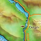
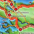
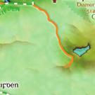
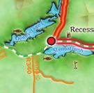
2 Lough INagh The Western Way
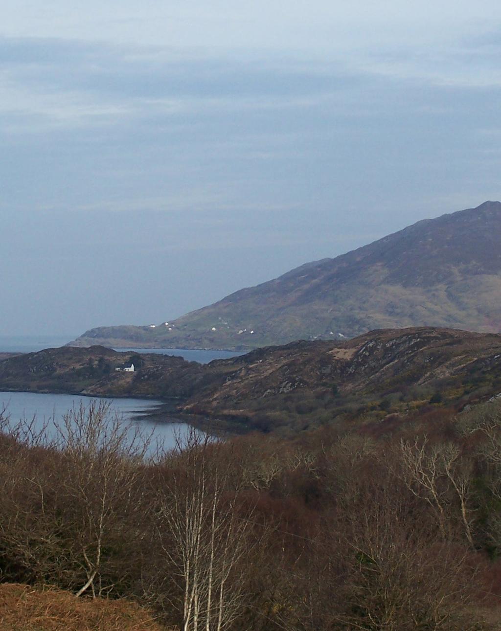
3 Distance: 16 km Time: 4 hour The Walk Lough INagh The WesTerN Way Level:Easy (may be muddy in patches Route Shape: Looped Start out from the Lough Inagh Lodge (A) walk left towards Recess and when you reach the little car park at the end of the wood (B), turn left up the hill, signed Mamean. Almost immediately the good views begin, at first back towards Lough Inagh and then forward to the Maumturks. As you approach towering Cnoc na huilleann, you reach (less than 1.5 km from the start) an obvious Western Way sign (C), and you leave the road to follow this sharp left, heading generally Northwest on the grassy way. The way is mostly obvious, and there are a few gates and a few WW wooden posts to reassure you. You simply go along the valley with Binn Briochain and its quartzite ridges high bove your right shoulder. Keep and eye out for a ruined homestead and a walled compound on your right. There are by now lovely views back down the valley and across left to he Gleninagh, (Gleann Eidhneach, the Ivy Glen) flanked by Ben Baun and Ben Dubh. One particularly rocky outcrop just to the left of the Way, where a rusty-roofed house is visible below on your left, is a good spot to stop and survey all around. Beware of some final mucky patches just before the Way reaches a stony little road, which brings you down to a bridge across a babbling river (D). Here the Western Way goes right, into a wood, but you stay on the little road as it goes down past a homestead to another secluded bridge. The next part of your route is very scenic, crossing westward along the top of the valley. Then the narrow road drops gently to bring you to the main valley road (E), where there are good views over towards Kylemore Lough. Your way home is to turn down left along the valley road, here the Lough Inagh awaits, now about an hour s walk away.
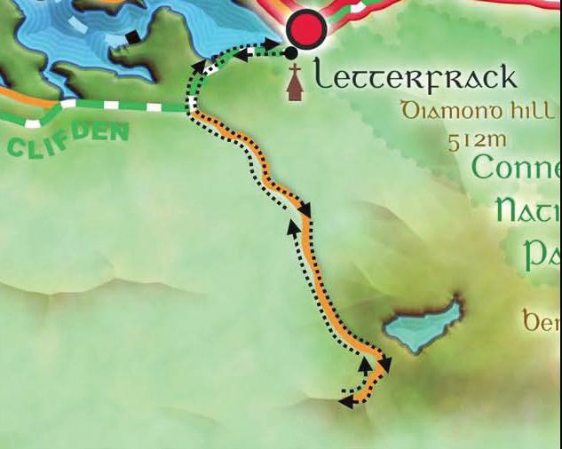
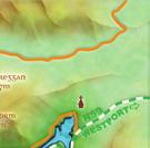
4 LETTERFrack Cregg Walk
5 LeTTerFrack - cregg Distance: 3km or 5km Time: 30 minutes or 1 hour Level: Easy Route Shape: There and Back The Walk Drive from Connemara West Centre, turn left and take the road to Clifden. Within a half mile, you will see Barnaderg Bay on your right, with a small jetty and old fishing boat. Behind that you can see the Rosleague Manor Hotel. A few hundred yards further on you pass the Hotel entrance on your right and on the next right-hand bend, next to a yellow no dumping sign, you turn left. The road from here is, but taken slowly should present no problems. After about two miles you will see on your right the buildings of the disused marble workings where the famous Connemara green marble was quarried. Park your car on the roadside anywhere in the area. The road continues from here to the top of Cregg Hill which is a distance of about half a mile. It is best to walk this since manoeuvring space for vehicles at the top is limited. You will be rewarded by the magnificent views. Below you to the northeast, you will see Lough Nahillion nestling high in the hills. To the North and North- West you will see views over Ballinakill Harbour to the offshore islands in the Atlantic. The Twelve Bens can be seen to the East, Clifden to the South-West, and to the South is the valley of the Owenglen River. From the summit you are overlooking the Connemara bog lands including the Roundstone Bog lying further south. The area is particularly renowned for the variety of heather which it hosts and it also provides a habitat for Greenland White Fronted Geese, all of which are protected species within the European Communities. To the east, beyond the forestry, lie part of the Connemara National Park.
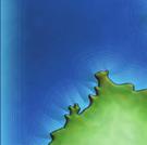
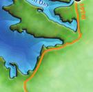
THE CONNEMARA LOOP COASTAL TRAILS.
 THE CONNEMARA LOOP COASTAL TRAILS When walking would you please respect the countryside and... Bring back all your own rubbish Take care of the flora and fauna in the area Please respect the land, the
Beautiful Walks from the Blue Ball Inn
 Walk No. 7 COAST AND VALLEY WALK Countisbury, Glenthorne, County Gate, Brendon, Rockford and Wilsham 10 MILES APPROX. Walking time 5 hours approx. (not including breaks)> OS Sheet 64/74 Lynton and Lynmouth.
Canoe Trip # Maps: 63L Amisk Lake 63M Pelican Narrows
 Canoe Trip #51 49 Southeast Arem Deschambault Lake - Pelican Narrows - Wunehikun Bay - Attitti Lake - Belcher Lake - Mukoman Lake - Ohoo Lake - Mukoman River - Sokatisewin Lake - Sandy Bay 170 Kilometers
The Mendip Way. Route Directions and Maps Wells to Frome
 The Mendip Way Route Directions and Maps Wells to Frome Website: www.mendiphillsaonb.org.uk Email: mendip@mendiphillsaonb.org.uk Facebook & Twitter: @MendipHillsAONB Phone: 01761462338 1 Wells to Shepton
Page 1 of 10
 Routt County, Colorado Properties For Sale: Trout Creek Lodge -1075 Deeded Acres List Price / per acre: $5,200,000 $4,837 Trout Creek Lodge and Ranch is the gem of the Trout Creek Valley, located along
The North Pennines from near Langwathby
 3.6 Langwathby to Armathwaite Map panel?? Distance 12.7 miles (20.5 km) Terrain farm, woodland and riverside paths; some potentially muddy tracks; a few short sections of road Grade gently undulating Food
The Worcestershire Beacon Race Walk. The Worcestershire Beacon Race Walk
 The Worcestershire Beacon Race Walk This is an abridged version of walk 5, taken from the Pictorial Guide to the Malvern Hills Book Two: Great Malvern. Copies are available from the Tourist Information
The Hundred Parishes
 The Hundred Parishes Walks from railway stations number 9 6.4 miles (10kms) from Bishop s Stortford to Stansted Mountfitchet Start: Bishop s Stortford station (Grid Reference TL492209) (ample parking and
Lincolnshire Limewoods Walks. Woodhall Spa. A circular walk of 13km (8 miles)
") Lincolnshire Limewoods Walks Woodhall Spa A circular walk of 13km (8 miles) Introduction The Lincolnshire Limewoods is an area between Wragby, Bardney and Woodhall Spa. It is a fantastic place to explore
Lincolnshire Limewoods Walks Woodhall Spa A circular walk of 13km (8 miles) Introduction The Lincolnshire Limewoods is an area between Wragby, Bardney and Woodhall Spa. It is a fantastic place to explore
Walk: NOC 08 Location: Cym Glyn near Brecon
 33 Walk: NOC 08 Location: Cym Glyn near Brecon Directions: Not easy to find at all. Go to Libanus, then head towards Brecon on the A470. Take minor C road single track lane first right as you come out
Explore the outdoors in Shelby County
 Explore the outdoors in Shelby County Oak Mountain Trail GPS: 33.283831-86.865238 Trail Location: Address: Oak Mountain State Park Trail 200 Terrace Drive Pelham, AL 35124 Type of Trail: Walking, Mountain
Little Digger Track to Davidson Reserve and Lyrebird Circuit
 Little Digger Track to Davidson Reserve and Lyrebird Circuit 4 hrs 3 mins 11.5 km One way Hard track 4 47m Exploring both the eastern and western sides of Middle Harbour Creek, this walk follows the Little
WETHERBY CIRCULAR by Tania Dickinson
 WETHERBY CIRCULAR by Tania Dickinson This walk in lower Wharfedale includes a disused railway line at the beginning and riverside at the end, with parkland, fields, woodland and villages in between. Distance
THE BECK STONE Backstone Beck on Ilkley Moor
 THE BECK STONE Backstone Beck on Ilkley Moor 1 Three different routes which take in the best of the lower slopes of Ilkley Moor, with bracken, heather, a tarn (a small mountain lake) and rushing streams.
The Worcestershire Beacon Race Short Walk. The Worcestershire Beacon Race Walk
 The Worcestershire Beacon Race Walk This is an abridged version of walk 5, taken from the Pictorial Guide to the Malvern Hills Book Two: Great Malvern. This walk seeks to avoid where ever possible very
GARRAUNBAUN LODGE. Moyard, Clifden, County Galway, Ireland
 GARRAUNBAUN LODGE Moyard, Clifden, County Galway, Ireland GARRAUNBAUN LODGE, MOYARD, CLIFDEN, COUNTY GALWAY, IRELAND A MAGNIFICENTLY SECLUDED 4 BEDROOM HOME APPROX. 300 SQ.M / 3,230 SQ.FT IN A MAJESTIC
Bonnie Prince Charlie Walk
 Bonnie Prince Charlie Walk A waymarked route from Ashbourne to Derby to celebrate the 60th anniversary (1995) of the formation of the Ramblers' Association. This route follows the general direction of
Tinneyhall Wood, Cornwall - About 9 ½ acres, 59,000
 Tinneyhall Wood, Cornwall - About 9 ½ acres, 59,000 Tinney Hall is a hamlet close by the small hilltop village of Lewannick, which is centred around a crossroads. This is unusual for Cornwall, where the
glenlo Abbey hotel Welcoming guests since 1740
 Glenlo Abbey Hotel, Kentfi eld, Bushypark, Galway t: +353 91 519600 f: +353 91 527800 e: info@glenloabbey.ie w: www.glenloabbeyhotel.ie #GlenloAbbeyHotel @Glenlo_ Abbey your personal guide glenlo Abbey
Hornsby Blue Gum Walk
 Hornsby Blue Gum Walk 3 hrs Hard track 6.7 km Circuit 4 374m This delightful loop is one of the prettiest and most popular walks in the Hornsby area. Going from an environment of ferns and clear bushland
Follow the Lantern Way clockwise from Dursley Town Hall through Cam & Coaley to Uley and back to Dursley (about 14 miles)
") According to the Rev Kilvert's diary of 1873, couples on their way to evening services in winter followed a practical though unusual local tradition: "My Mother says that at Dursley, when ladies and gentlemen
According to the Rev Kilvert's diary of 1873, couples on their way to evening services in winter followed a practical though unusual local tradition: "My Mother says that at Dursley, when ladies and gentlemen
Harlington - Sharpenhoe - Pulloxhill
 Harlington - Sharpenhoe - Pulloxhill ID: 3676, Distance: 8 miles, Height gain: 140 Metres, Map: Explorer 193 Luton & Stevenage, Contributor: Dennis Jeanes Duration: 3 Hours 27 Mins Features Church,Great
NEWLANDS CORNER AND ST MARTHAS
 NEWLANDS CORNER AND ST MARTHAS 10k CIRCULAR ROUTE 2½-3HRS GU4 8SE From Newlands Corner on the North Downs just outside Guildford, you can enjoy one of the most beautiful panoramas of quintessential English
Start / Finish. Version 2
 Start / Finish Version 2 Gosford (Start) to Woy Woy Head South down Etna Street, crossing Henry Parry Drive, then Mann St, Gosford, where Etna St becomes Racecourse Road. Follow this road all the way
Lincolnshire Walks. Grainthorpe. Three circular walks of 2 ¾, 9 and 9 ½ km (1 ¾, 5 ½ and 6 miles)
") Lincolnshire Walks Grainthorpe Three circular walks of ¾, 9 and 9 ½ km (1 ¾, ½ and 6 miles) Introduction Explore the coastal marshes, arable hinterland, Louth Navigation canal and the village of Grainthorpe
Lincolnshire Walks Grainthorpe Three circular walks of ¾, 9 and 9 ½ km (1 ¾, ½ and 6 miles) Introduction Explore the coastal marshes, arable hinterland, Louth Navigation canal and the village of Grainthorpe
Pull the gate towards you and ride through. The third gate takes you onto Hound House Road. Watch out for traffic. 4
 PEASLAKE TO FARLEY HEATH AND WINTERFOLD 12k CIRCULAR ROUTE 2HRS GU5 9QW This interesting trail takes you across a variety of terrain, from the sandstone of Pitch Hill, across open farmland with fabulous
Falls Lake Trail (A part of the NC Mountains-to-Sea Trail) East to West
 East to West") Falls Lake Trail (A part of the NC Mountains-to-Sea Trail) East to West Section 1 (Falls of the Neuse Rd to Raven Ridge Rd) 0.0 mi Parking area of the Tailrace Fishing Area, just below the dam, off Falls
Falls Lake Trail (A part of the NC Mountains-to-Sea Trail) East to West Section 1 (Falls of the Neuse Rd to Raven Ridge Rd) 0.0 mi Parking area of the Tailrace Fishing Area, just below the dam, off Falls
Scenic World to Echo Point
 Scenic World to Echo Point 1 hr 15 mins 2.1 km One way Moderate track 192m This is one of the most popular tourist walks in the Katoomba area. The walk follows the cliffs along a well maintained and signposted
Walk Description. Directions
 Title: Saffron Trail: Battlesbridge to Chelmsford Distance: 14¾ miles Time taken: 6 hours Start Point: Outside the Barge Inn, Battlesbridge OS Explorer Map: 175 & 183 Grid Ref.: TQ 780 947 Transport: Rail:-
Currie Rd to Davidson Park
 Currie Rd to Davidson Park 3 hrs 7.2 km One way Moderate track 28m Starting at Currie Rd in Forestville, this walk follows Middle Harbour to Davidson Park, under Roseville Bridge. There are two optional
Dead Horse Gap Loop track
 Dead Horse Gap Loop track 4 hrs 30 mins Hard track 9.8 km Circuit 144m 4 This walk starts with a ride up the Kosciuszko Express Chairlift. There is an opportunity to eat at Australia's highest restaurant,
NETTLESTEAD & YALDING
 NETTLESTEAD & YALDING ULL CIRCUIT - Sheet 1 (first and last sections) Open fields (see 'Introductory Notes') 88 Direction label (as in the walk notes) ROADS: 81 10m Significant roads Redhill arm North
Masson Hill. Walk. Approximately 4 km. Moderate Walk Begins from Matlock Railway Station
 Masson Hill Walk Approximately 4 km Moderate Walk Begins from Matlock Railway Station TOWN WALKS Masson Hill walk is approx. 4 km. It can be walked in a couple of hours or so. Enjoy your walk and the beautiful
Sid Pulsford Walk. 175m. 33m. 1 hr 45 mins 4.1 km One way. Hard track 118m. Gosford LGA
 Sid Pulsford Walk 1 hr 5 mins.1 km One way Hard track 118m Sid Pulsford Walk explores the ridge top of Kincumber Mountain, from Honeman's Rock to Green Point. The walk mostly follows wide management trails.
Ashdown Forest, Fairwarp Rock Wood and Purple Heather
 point your feet on a new path Ashdown Forest, Fairwarp Rock Wood and Purple Heather Distance: 14 km=9 miles or 2 walks of 10 km=6 miles and 8 km=5 miles moderate walking Region: East Sussex Author: Stivaletti
Directions for Day 1: Colwood To Metchosin
 Colwood-Metchosin Page 1 of 8 Directions for Day 1: Colwood To Metchosin Start: Royal Roads University, Birds of a Feather B&B, or at Esquimalt Lagoon Finish: Your accommodation in Metchosin Time: 4-5
Waterhead Pier to Orrest Head, Windermere and Bowness
 Waterhead Pier to Orrest Head, Windermere and Bowness A 4 1 2 hour walk through Woodlands and the Troutbeck Valley with spectacular Lake and Mountain views and a lakeshore path. Walk 10 Walk 11 Walk 12
Hexham Abbey to the Racecourse Road
 Hexham Abbey to the Racecourse Road The Yarridge Road, or Racecourse Road as it is often known, runs along the ridge line to the south of Hexham and provides wonderful views of the river valley and fells
Dorridge & District Residents Association A Walk Along The Green Belt From Dorridge to Catherine-de-Barnes
 Dorridge & District Residents Association A Walk Along The Green Belt From Dorridge to Carine-de-Barnes The starting section of this walk through open fields would be destroyed by building of motorway
Wentworth Falls Conservation Hut Loop
 Wentworth Falls Conservation Hut Loop 3 hrs Hard track 6.7 km Circuit 4 341m This scenic walk from Wentworth Falls Station, winds along the Nature Trail to Conservation Hut, then drops into the magnificent
1 Identify and explain ten important road signs.
 ROAD SAFETY ADVENTURER AWARD BOOK By Lyn Webb 1 Identify and explain ten important road signs. What does a SPEED LIMITED AREA sign mean? These signs are used to indicate an area where a lower speed limit
holly tree Wellhill Farm Woodyard Bramham House red kites Round House ha-ha
 This 6.4 mile walk around the magnificent Bramham Park Estate has been made possible with the active support of the owner of the Estate, Nick Lane Fox, with funding from Natural England, as part of Defra
TREC Ireland. Open Championships 2018 Including a FITE European Cup class 11 th to 13 th May 2018
 TREC Ireland Open Championships 2018 Including a FITE European Cup class 11 th to 13 th May 2018 Consisting of full 3 phase competition from level 1, 2, 2A, 3 and 4 Slieve Aughty Centre, Kylebrack West,
Falls Lake Trail (A part of the NC Mountains-to-Sea Trail) East to West
 East to West") Falls Lake Trail (A part of the NC Mountains-to-Sea Trail) East to West Section 1 (Falls of the Neuse Rd to Raven Ridge Rd) 0.0 mi Parking area of the Tailrace Fishing Area, just below the dam, off Falls
Falls Lake Trail (A part of the NC Mountains-to-Sea Trail) East to West Section 1 (Falls of the Neuse Rd to Raven Ridge Rd) 0.0 mi Parking area of the Tailrace Fishing Area, just below the dam, off Falls
Hardman Triathlon Route: Bike (180km)
") Hardman Triathlon Route: Bike (180km) Outline map of the Ring of Kerry Starting from Transition 1 in the Killarney Golf & Fishing Club you will make your way up the road towards the exit. At the exit from
Hardman Triathlon Route: Bike (180km) Outline map of the Ring of Kerry Starting from Transition 1 in the Killarney Golf & Fishing Club you will make your way up the road towards the exit. At the exit from
Cross Country Skiing in the Tumbler Ridge Area
 Cross Country Skiing in the Tumbler Ridge Area There are numerous locations that are great for cross country skiing in the area surrounding Tumbler Ridge. Some are on trails that have hiking brochures
RIDE THE HIGH PASSES OF THE ALPS. July 2 to July Please contact us for other dates.
 RIDE THE HIGH PASSES OF THE ALPS July 2 to July 9 2018 Please contact us for other dates. Have you ever dreamed of riding some of the Alps most famous passes and climbs ridden regularly during the Tour
Walks in Lenham. Three delightful walks in and around Lenham from 30 minutes to 90 minutes with map and photographic guides. l l l ABOUT LENHAM
 Walks in Lenham Three delightful walks in and around Lenham from 0 minutes to 90 minutes with map and photographic guides l l l ABOUT LENHAM The medieval village of Lenham, in the Borough of Maidstone,
Walk 2: Beamsley Beacon and Bolton Abbey
 Walk 2: Beamsley Beacon and Bolton Abbey Start and Finish: The Memorial Hall, Main Street, Addingham, LS29 0LZ, SE 079 497 The shortest walk is about 5½ miles (8.8km) The medium Walk is about 8¼ miles
Track & Trail River Camp. South Luangwa National Park, Zambia
 Track & Trail River Camp South Luangwa National Park, Zambia Track & Trail River Camp Track & Trail River Camp is a privately owned lodge located on a breathtaking spot on the banks of the Luangwa River
Castlemorris Wood Walk
 Castlemorris Wood Walk Trail Tips This walk is one of a range of scenic walks developed by trailkilkenny and designed to allow you explore more of the great outdoors; bringing Kilkenny s wonderful countryside
How to get there. Respect - Protect - Enjoy
 How to get there Driving: Postcode is RG9 3DG and there is a carpark just across from the pub. Nearest station: Henley-on-Thames station is 5.6 miles away. We re delighted to present three circular walks
Approach. Via Stewart Creek Three Sisters
 three sisters The Three Sisters are a signature landmark for the Bow Valley and the town of Canmore. They may even compete with Mount Rundle above Banff as the most photographed and painted mountain scene
LDWA SOUTH DOWNS MARATHON 13 th MAY 2018
 AHD ahead SDW South Downs Way BL/BR bear left/bear right TL/TR turn left/turn right X cross LEG 1 - EAST DEAN to WP1 NORTON GR 470019. Open 1030 to 1300. 9.7 miles. 1.1 From village hall TL and walk to
GIVE EVERYTHING YOU HAVE AND THEN GIVE MORE
 GIVE EVERYTHING YOU HAVE AND THEN GIVE MORE REVISION 4: 11TH JUNE 2018 COMPETITIOR IMPORTANT INFO PLEASE NOTE: Roads are not closed for this race. They are busy, narrow and very steep. Athough it is a
Sphinx to Mt Kuring-gai
 Sphinx to Mt Kuring-gai 4 hrs 45 mins 1.7 km One way Hard track 673m This walk starts at the Sphinx War Memorial and follows some well maintained and popular walking tracks down to Cowan Creek. Enjoy the
From Humble beginnings 1950 s
 THE NOWRA GOLF COURSE Nowra Golf Club nestling on the banks of the beautiful Shoalhaven River, although not long, presents a challenge to all golfers 5,166 Metres par 68 Men 5,050 Metres. Par 71 Women
Green Point Circuit Walk
 Green Point Circuit Walk 3 hrs 7.7 km Circuit Hard track 269m This walk visits all of the popular locations in Green Point Reserve, as well as some of the lesser-visited areas inland. Taking in Sea Eagle
BEACH ACCESS INVENTORY 2014 Electoral Area A
 BEACH ACCESS INVENTORY 2014 Electoral Area A Site Inventory and report compiled by the Electoral Area A Parks, Recreation and Culture Commission members: Alec McPherson, Andrew Thornton, Angela Vincent,
Chichester Harbour. A Walker s Guide
 A Walker s Guide - Chichester Harbour Chichester Harbour A Walker s Guide Chichester Harbour is an Area of Outstanding Natural Beauty on the south coast of Britain. Virtually flat with far reaching sea
Bagshot Heath and Swinley Forest
 point your feet on a new path Bagshot Heath and Swinley Forest Distance: 13 km=8 miles Region: Berkshire, Surrey Author: Botafuego Refreshments: Forest Look Out, Bagshot easy walking Date written: 17-feb-2013
PLACES OF INTEREST ALONG THE ROUTES
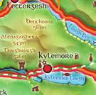
 PLACES OF INTEREST ALONG THE ROUTES The Benwiskin Centre is nestled between the Atlantic ocean and the dramatic mountains of Benwiskin,Truskmore and Tievebaun. An area of natural beauty, inhabited with
Map Showing NAFO Management Units
 Map Showing NAFO Management Units Biology Are 6 species of seals in Atlantic Canadian waters, all of which occur in Newfoundland Two Arctic Species (Ringed, Bearded) Two temperate (Grey, Harbour) Two migratory
Poundgate and The Hurstwood
 point your feet on a new path Poundgate and The Hurstwood Distance: 11 km=7 miles Region: East Sussex Author: Stivaletti Refreshments: High Hurstwood easy walking Date written: 24-jul-2016 Last update:
Sunday 24th July, 1932
 A Cairngorm Diary 24th -29th July, 1932 Written en route by James Nicoll Kerr Henderson (1908-1989) Edited and word-processed from the original by his son John Henderson in April, 2000 Maps added in 2008.
To Benefit the Wachusett Mountain Race Team!
 To Benefit the Wachusett Mountain Race Team! Handbook Outline: Race Overview & Events Schedule....3 Leg 1: 5-mile Run... 4 Leg 2: Scenic Bike Race.....5 Leg 3: Summit Climb......6 Leg 4: Ski Run...7 Application.....8
Ambergate & Betty Kenny's Tree.
 Walk Information Walk Area: Ambergate OS Map: Explorer OL24 Distance: 4 Miles White Peak Area Start Point: Holly Lane, Ambergate 1:25000 Map Ref: SK 346 254 Post Code N/A General Information Altitude Data
SUMMER WALK 10. The Chairmakers, Worlds End
 SUMMER WALK 10 The Chairmakers, Worlds End Tuesday 10 th June 7.30pm This is a very short walk made so due to the majority of the footpaths in the area around the Chairmakers being overrun with high nettles
The Homestead PHOTO GALLERY
 Troy, my little dog Benji and I (Kathy), in 2003, standing on the verandah of our new home. You can see there were no ant caps over the stumps because instead of having stumps that were separate from the
Middle Harbour Creek Loop
 Middle Harbour Creek Loop 5 hrs 45 mins 15.1 km Circuit Experienced only 5 570m This walk explores the upper reaches of Middle Harbour Creek, starting and ending at the great parklands at Davidson Park,
9.5 km Circular 3 hours
 MEDIEVAL WAVERLEY Challenging Terrain A 6 mile (9.5km) undulating circular walk from Tilford village passing close to The Sands village and the historic ruins of Waverley Abbey. From the top of Crooksbury
Sandilands to Huttoft Bank
 Coastal Country Park Walks Sandilands to Huttoft Bank A CIRCULAR WALK OF 11KM (7 MILES) INTRODUCTION The Lincolnshire Coastal Country Park lies between Sandilands, Chapel St Leonards and Huttoft on the
Macutagon Creek to Russell s Landing
 Day Trips Macutagon Creek to Russell s Landing Manitouwadge Public Consultation Committee Canoe Route #13 #13 MACUTAGON CREEK TO RUSSELL S LANDING This route is suitable to all levels of paddlers but due
THE WELLDIGGERS ARMS, HESWORTH AND FITTLEWORTH TRAIL
 THE WELLDIGGERS ARMS, HESWORTH AND FITTLEWORTH TRAIL 5.5 miles Circular 3 hours 041017 Challenging Terrain A 300-year-old pub turned country-inn on the edge of the South Downs National Park, The Welldiggers
Slindon Folly - South Downs, West Sussex
 Slindon Folly - South Downs, West Sussex Starts at Park road-side near entrance to Slindon College 2 hours 15 minutes 4.5miles 7.2km Easy ID: 0.1598 Developed by: Chris Mumford Checked by: Rockpit www.ramblersroutes.org
Canoe Route. Dogtooth Lake-Highwind Lake-Dryberry Lake- Lake of the Woods-Blindfold Lake
 1 Canoe Route Dogtooth Lake-Highwind Lake-Dryberry Lake- Lake of the Woods-Blindfold Lake This is an interesting and challenging route starting and ending at Rushing River Provincial Park. It passes over
8 Miles Circular 4 hours
 VISIT RYEDALE HELMSLEY AND RICCAL DALE 8 Miles Circular 4 hours 090616 Challenging Terrain An 8 mile (13km) circular walk from the market town of Helmsley in Ryedale. The route heads out across sheep pastures
Distance: 5 km=3 miles or 4½ km=2¾ miles or 3½ km=2 miles
 point your feet on a new path Vann Lake Distance: 5 km=3 miles or 4½ km=2¾ miles or 3½ km=2 miles Region: Surrey Author: Schwebefuss Refreshments: Ockley easy walking Date written: 12-feb-2011 Date revised:
Where to watch the Isle of Man TT
 Where to watch the Isle of Man TT We have put together a spectator guide the Isle of Man's world famous TT course. No other circuit in the world compares to the 37 mile plus Mountain Course with its neverending
Quality Assurance Statement. Prepared by: Glen Koorey. Reviewed by: Axel Wilke. Project Number: Version: 1
 Level 1, 284 Kilmore Street PO Box 22 458, Christchurch 8140, New Zealand T: 03 366 7605 E: info@viastrada.co.nz To: Safe Roads / NZ Transport Agency Attn: Liv Theunissen Date: 21 August 2018 Re: ATP installation
Floating Pennywort Project. River Medway and River Cray locations
 Floating Pennywort Project River Medway and River Cray locations 2011 Andrea Griffiths (BSc) Partnership Officer Medway Valley Countryside Partnership MVCP Floating Pennywort Report 2011 Andrea Griffiths
Southbourne. Site briefing mandatory on first visit. See special restrictions. IMPORTANT INFORMATION
 Site Code 2.086 OS Grid Ref: SZ 130 913 (Map 195) GPS: N50:43.270 Owned by: Nearest Phone: Casualty Units: W1:49.032 Bournemouth Council 01202 451145 Opposite Commodore Hotel Royal Bournemouth Castle Lane
Special request, Advice June New information regarding the impact of fisheries on other components of the ecosystem
 1.5.1.2 Special request, Advice June 2013 ECOREGION SUBJECT General advice New information regarding the impact of fisheries on other components of the ecosystem Advice summary ICES advises that the following
Figure 1, Chart showing the location of the Breach at Old Inlet and sensors deployed in Great South Bay.
 The Impact on Great South Bay of the Breach at Old Inlet Charles N. Flagg and Roger Flood School of Marine and Atmospheric Sciences, Stony Brook University The Great South Bay project (http://po.msrc.sunysb.edu/gsb/)
VELINDRE VALLEYS WALK FOR STEFFAN
 VELINDRE VALLEYS WALK FOR STEFFAN IMPORTANT INFORMATION FOR WALKERS AND MARSHALS 1 Table of Contents Key Contact Numbers:... 3 Timetable and locations... 4 T-shirts... 4 Important Advice for Walkers...
Chanctonbury, Steyning & the South Downs A Ring with a View
 point your feet on a new path Chanctonbury, Steyning & the South Downs A Ring with a View Distance: 12½ km=8 miles easy-to-moderate walking Region: West Sussex Date written: 5-aug-2010 Author: Hautboy
Distance: 14 km=8½ miles or 7 km=4½ miles easy-to-moderate walking
 point your feet on a new path Normandy Distance: 14 km=8½ miles or 7 km=4½ miles easy-to-moderate walking Region: Surrey Author: Botafuego Refreshments: Pirbright, Ash date written: 20-feb-2012 date revised:
Wonderful facilities Rory McIlroy, Professional Golfer
 Wonderful facilities Rory McIlroy, Professional Golfer Trump International Set amidst The Great Dunes of Scotland, Trump International Golf Links embraces mile after mile of spectacular Aberdeenshire coastline
" T h e S p e c t a c u l a r T o u r "
 Platinum Pro Golf Tours presents " T h e S p e c t a c u l a r T o u r " T h e N e w Z e a l a n d t o u r 4 nights and 5 days at New Zealand's top ranked gold courses. Jack's Point The Hills Millbrook
A Walk around Holmes Chapel starting & finishing at Holmes Chapel Railway Station. by Tony & Lindsay Wright (2016)
") A Walk around Holmes Chapel starting & finishing at Holmes Chapel Railway Station. by Tony & Lindsay Wright (2016) Introduction Holmes Chapel Railway Station is on the Crewe to Manchester line. The station
A Walk around Holmes Chapel starting & finishing at Holmes Chapel Railway Station. by Tony & Lindsay Wright (2016) Introduction Holmes Chapel Railway Station is on the Crewe to Manchester line. The station
Christchurch to Hengistbury Head
 Last checked 6 June 2018 Document last updated: 13 July 2018 This document and information herein are copyrighted to Saturday Walkers Club. If you are interested in printing or displaying any of this material,
LOCAL CIRCUIT EM1: EAST MALLING & BARMING HEATH. N 2m ROADS: Significant roads PATHS: Starting direction Barming Longsole Mission Church
 Ditton Church Scott Close LOCAL CIRCUIT EM1: EAST MALLING & BARMING HEATH 6 Community Centre F Open fields (see 'Introductory Notes') 1m 88 Direction label (as in the walk notes) East Malling Church -
FINAL DETAILS - RACE 2 GOYT VALLEY
 FINAL DETAILS - RACE 2 GOYT VALLEY Thank you for entering the second event in the 2018 series, where we ve gone back to the usual format of the 3 hour event. We are pleased to see you at this first Peak
About The Big Bend Open Road Race U.S 285 Course Notes
 2018 About The Big Bend Open Road Race U.S 285 Course Notes Course notes for 2018, Ft. Stockton to Sanderson and return. * Please note that these course notes are based on the 2017 race. You will notice
Hascombe and Winkworth Arboretum Downs Link Path, Smithbrook Kilns
 point your feet on a new path Hascombe and Winkworth Arboretum Downs Link Path, Smithbrook Kilns Distance: 18 km=11 miles Region: Surrey Author: RDC easy walking Date written: 7-may-2016 Last update: 30-aug-2018
A circular walk of or km (2 1 4 or miles)
") Grantham A circular walk of 3 3 4 or 5 3 4 km (2 1 4 or 3 1 2 miles) Introduction This relatively short circular walk, which starts in the middle of Grantham, offers plenty of variety. The route takes
Grantham A circular walk of 3 3 4 or 5 3 4 km (2 1 4 or 3 1 2 miles) Introduction This relatively short circular walk, which starts in the middle of Grantham, offers plenty of variety. The route takes
Kinghorn pathways KINGHORN COMMUNITY COUNCIL
 Kinghorn pathways A choice of short to long distance trails for walkers, cyclists and horse-riders. Superb sea and country views with abundant wildlife. KINGHORN COMMUNITY COUNCIL In Scotland you have
Taronga Wharf to Chowder Bay
 Taronga Wharf to Chowder Bay 2 hrs 4.4 km One way Moderate track 246m Starting at Taronga Wharf, this walk passes many icons of Sydney, including Taronga Zoo, HMAS Sydney Mast, Chowder Bay. The walk also
Detailed maps, and portaging and camping information follow.
 Overview of Bain route. The launch site is at Davidson Lake, just before the Manitoba/Ontario border. You can do a loop if you leave a vehicle at Tulabi Lake (at the canoe route parking lot). The road
Approximate distance: 10 miles For this walk we ve included OS grid references should you wish to use them. Start. End
 Approximate distance: 10 miles For this walk we ve included OS grid references should you wish to use them. 2 3 Start End 1 N W E S Reproduced by permission of Ordnance Survey on behalf of HMSO. Crown