Southbourne. Site briefing mandatory on first visit. See special restrictions. IMPORTANT INFORMATION
|
|
|
- Michael Powell
- 6 years ago
- Views:
Transcription
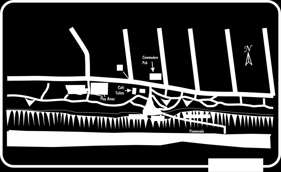
1 Site Code OS Grid Ref: SZ (Map 195) GPS: N50: Owned by: Nearest Phone: Casualty Units: W1: Bournemouth Council Opposite Commodore Hotel Royal Bournemouth Castle Lane Wind Direction SSE - SSW (160 to 200 ) Best: S (180 ) Height AMSL Top to Bottom Pilot Grades 150ft (50m) 150ft (50m) HG Not permitted PG Pilot MANDATORY Site briefing mandatory on first visit. See special restrictions. IMPORTANT INFORMATION EVERY PILOT WHO FLYS HERE MUST HAVE THEIR NAME LOGGED WITH THE TOWN HALL BY LEAVING A VOIC ON THE NUMBER BELOW* THE VOIC NUMBER IS put it in your phone now. This means, BEFORE FLYING on each visit, each individual pilot MUST telephone the voic and log their name in. Several people may do this on one phone call but each individual name must be stated. Leave your name, BHPA number and wing colour, then hang up. Also before flying at least one person MUST notify Bournemouth Air Traffic Control that Paragliders will be flying. Call It is far better that ATC receive 10 calls than none. If you arrive to find wings airborne call in yourself to make sure ATC are aware, do not just assume someone else has done it. THIS IS A WESSEX MEMBERS ONLY SITE JULY AND AUGUST RESTRICTED FLYING HOURS: Flying is ONLY allowed before 10:00 and after 18:00. You must land IMMEDIATELY (wherever you are) at 10:00 no one should be airborne after 10:00. ANY infringements will result in the no-fly restriction being reinstated. Page 1 of 5
2 General Site info is undoubtedly our most public and most sensitive site. On a typical day you will almost certainly have several hundred pairs of eye s watching you as you fly. There are always members of the public around take off and landing areas, let alone passing cars and nearby properties. The site was lost to us for a while after a problem with Bournemouth Air Traffic Control. The Council can also be very tense about use of the site and it really would not take much to tip the scales and get the site closed again. For this reason the site has certain restrictions which MUST be strictly followed. This is not like one of our OK its Pilot rated but I ll fly it anyway type of sites. If it says you can t do something here then DON T. The site can provide some excellent flying and is conveniently situated for many pilots. Flying in a built up area also adds to the novelty of the site and the onlookers can be an appeal to some people as well. *The list of pilots logged at the Town Hall consists of all members who are shown as PG Pilot rated in the club membership database. An updated list is sent regularly, but if you have recently obtained your pilot rating and wish to fly here please contact the club secretary to make sure you are added to the list. For those members who have been pilot rated for some time it may be prudent to ensure the membership database has your correct rating. Your rating can be verified or checked online at the Wessex website. Page 2 of 5

3 Page 3 of 5
4 Directions Access From Christchurch, go over the Tuckton Bridge, follow the road to the top of the hill, turn left by Chick King and right at the roundabout. Proceed west along Overcliff Drive. From other areas, get to Boscombe and find your way to the coast east of Boscombe Pier. Proceed along Overcliff Drive. Park on the roadside near to the Commodore Pub. Obvious, simply step off pavement onto the grass opposite the Commodore Pub. Parking Roadside anywhere in the area. Hazards You are flying inside Bournemouth Airspace. 1. You must be good and neat at ground handling getting dragged about is not an option. There is a road 20m behind take-off. Use an anchorman if necessary. 2. When taking off you have to clear the wall and/or the fence in front of the take-off and miss the lamppost just to the right. Make sure no spectators are standing in the way. 3. Especially on light wind days, get a good steady push from another pilot. The pusher must stay with (under) you as far as the wall/fence to give a secondary push if necessary. 4. If the wind is westerly, watch for rotor from the building to the right/front of take-off. 5. Be aware that there is little or no beach at high tide along parts of the length of the flyable area. If you are forced to land on the beach in this situation, you have the double hazard of the potentially lethal water on one side and the promenade and lamp posts on the other. Launching There is only one small knoll of grass that we are allowed to take off from. See diagram. Top Landing The primary top landing area is the grassy area just east of take off or on the take off area itself. DO NOT land on the immediate west side of the take off as it can scare children within the sand pit area. An alternate top landing area is available to the west of the play area; the Council have classed this an a Reserve landing area for use when either the primary landing area is busy with members of the public or flying conditions make it preferable to use. Be sure to land in front of the path to avoid rotor. DO NOT land anywhere on the side of the cliff a 200 fine is possible. Page 4 of 5
5 Bottom Landing Bottom landing is the beach. Only beach land when you have to, i.e. not enough wind to top land or too much for a safe top land. As mentioned previously, watch out for high tides, groynes and especially lampposts on the promenade. Don t scratch too low. Turn out early, above the lampposts on the promenade. Try and land neatly to avoid excessive sand getting inside the cells of the canopy. At low tide there are acres of sand to land on except in high summer when people use the beach and we are not permitted to use the site anyway. Other Issues About half a mile to the east of take off, there are some flats and houses whose back gardens are on the top of the actual cliff. DO NOT FLY PAST THESE HOUSES ONE MORE COMPLAINT WILL LOSE US THE SITE. Turn just before the cliff and road dip inwards opposite Grange Road. Bournemouth Council is very strict about all rules. Please adhere to all rules and report any incident, however small, to a club committee member. BHPA licenses must be produced for Park or Beach Wardens if asked. Avoid soaring close to or for prolonged periods near any buildings particularly blocks of flats. Residents can feel their privacy is being compromised. If you observe any pilots launching or flying anywhere along this site who are not members of Wessex or are obviously contravening our site rules please call the Council Radio Room as soon as possible with a description of the gliders involved. This will help in avoiding us get blamed for others errors. Ridge runs, XC XC: NO. Flying westward is not restricted. However, you will need some height to jump the gaps at the piers and chines. The out and return to Sandbanks is about 18km. It is quite rare to be able to jump the pier gaps. Be very careful at the piers - landing could be very hazardous. Be aware also that you will probably have quite a large audience watching you as you take off this can be off putting the first time. Be polite to people asking questions. License number ( ) Reproduced by permission of Ordnance Survey on behalf of HMSO. Crown copyright. All rights reserved. Page 5 of 5
Owned by: Wessex HGPGC Ltd Wind Direction W - NNW (275 to 340 ) Best: NW (305 )
 Best: NW (305 )") Site Code 2.028 OS Grid Ref: ST 797 086 (Map 194) GPS: N50:52.549 W2:17.312 Owned by: Wessex HGPGC Ltd Wind Direction W - NNW (275 to 340 ) Best: NW (305 ) Farmed by: Mr Owen Yeatman Lowbrook Farm Belchalwell
Site Code 2.028 OS Grid Ref: ST 797 086 (Map 194) GPS: N50:52.549 W2:17.312 Owned by: Wessex HGPGC Ltd Wind Direction W - NNW (275 to 340 ) Best: NW (305 ) Farmed by: Mr Owen Yeatman Lowbrook Farm Belchalwell
Weatherman Walking Sully to Penarth Approximate distance: 5 miles End Start
 Approximate distance: 5 miles For this walk we ve included OS grid references should you wish to use them. 4 End Start 2 3 N W E 1 S Reproduced by permission of Ordnance Survey on behalf of HMSO. Crown
Site Guide June 2018
 Site Guide June 2018 Index Acknowledgements 3 Disclaimer 4 General Site Rules 5 Regional Maps 6 Hang-gliding Wind Rose 11 Paragliding Wind Rose 12 Ballard Down and White Cliff 13 Barton on Sea 18 Bell
Sir George Cayley Sailwing Club Site Guide, April 2018
 Sir George Cayley Sailwing Club Site Guide, April 2018 About the Club and this Guide. Welcome to the Sir George Cayley Sailwing Club. The Club was started in 1975 by a group of enthusiastic flyers in East
Christchurch to Hengistbury Head
 Last checked 6 June 2018 Document last updated: 13 July 2018 This document and information herein are copyrighted to Saturday Walkers Club. If you are interested in printing or displaying any of this material,
Approximate distance: 10 miles For this walk we ve included OS grid references should you wish to use them. Start. End
 Approximate distance: 10 miles For this walk we ve included OS grid references should you wish to use them. 2 3 Start End 1 N W E S Reproduced by permission of Ordnance Survey on behalf of HMSO. Crown
Lincolnshire Walks. Ancaster. Three cir cular walks of2 3/4,4or 6km (11/3, 21/2 or 33/4 miles)
") Lincolnshire Walks Ancaster Three cir cular walks of2 3/4,4or 6km (11/3, 21/2 or 33/4 miles) Introduction These walks are set in the attractive countryside around the historic town of Ancaster. The town
Lincolnshire Walks Ancaster Three cir cular walks of2 3/4,4or 6km (11/3, 21/2 or 33/4 miles) Introduction These walks are set in the attractive countryside around the historic town of Ancaster. The town
The British Hang Gliding and Paragliding Association National Open Paragliding Accuracy Championships 2017 LOCAL REGULATIONS
 GENERAL 1.1 Objectives The first objective of the competition is to determine the National Team Champions and National Champion of the UK Paragliding Accuracy Competition by means of a competition open
The British Hang Gliding and Paragliding Association National Open Paragliding Accuracy Championships 2015 LOCAL REGULATIONS
 GENERAL 1.1 Objectives The first objective of the competition is to determine the National Team Champions and National Champion of the UK Paragliding Accuracy Competition by means of a competition open
Lincolnshire Walks. Grainthorpe. Three circular walks of 2 ¾, 9 and 9 ½ km (1 ¾, 5 ½ and 6 miles)
") Lincolnshire Walks Grainthorpe Three circular walks of ¾, 9 and 9 ½ km (1 ¾, ½ and 6 miles) Introduction Explore the coastal marshes, arable hinterland, Louth Navigation canal and the village of Grainthorpe
Lincolnshire Walks Grainthorpe Three circular walks of ¾, 9 and 9 ½ km (1 ¾, ½ and 6 miles) Introduction Explore the coastal marshes, arable hinterland, Louth Navigation canal and the village of Grainthorpe
Maps The maps provided are a guide and are not to scale. Please use OS Explorer Map 120 (Chichester).
.") A Walker s Guide - Chichester Harbour Useful Information Directions All the walks were tested in 2013. Please note, however, that some footpaths may be diverted and buildings such as pubs may have changed
A Walker s Guide - Chichester Harbour Useful Information Directions All the walks were tested in 2013. Please note, however, that some footpaths may be diverted and buildings such as pubs may have changed
Outdoor property Access Statement Northumberland Coast
 Outdoor property Access Statement Northumberland Coast 7a The Square, Low Newton-by-the-Sea, Alnwick, Northumberland NE66 3EL T: 01665 576874 E: northumberlandcoast@nationaltrust.org.uk Introduction The
Ealing Minis Festival
 Ealing Minis Festival Saturday 18 th & Sunday 19 th November 2017 Registration from 08:30 Kick Off 09:30 https://ealingrugby.co.uk INFORMATION PACK EALING TRAILFINDERS RUGBY CLUB Castle Bar, Vallis Way,
WELCOME TO SANDOWN BEACH
 WELCOME TO SANDOWN BEACH Sandown is a recognized award winning beach, very popular for its long sandy beach with safe bathing and a wealth of activities. The local amenities and nearby town makes it a
New to PilotAware Start Here. Introduction to the PilotAware Classic ready to go Unit. PilotAware Classic May 2016
 New to PilotAware Start Here Introduction to the PilotAware Classic ready to go Unit. If you are new to PilotAware then you may be confused by the technical bias of most of the information that you have
Weatherman Walking. Approximate distance: 5.5 miles For this walk we ve included OS grid references should you wish to use them. Start.
 Approximate distance: 5.5 miles For this walk we ve included OS grid references should you wish to use them. 4 1 Start End 3 2 N W E S Reproduced by permission of Ordnance Survey on behalf of HMSO. Crown
COASTAL SOARING ASSOCIATION, INC. STANDARD OPERATING PROCEDURES Revised 09/17/2010
 A. General COASTAL SOARING ASSOCIATION, INC. STANDARD OPERATING PROCEDURES Revised 09/17/2010 1. The sailplane s canopy shall normally be kept closed and the spoilers open whenever the cockpit is unoccupied
Group walks & events manager: Getting Started for Contributors
 2017 Group walks & events manager: Getting Started for Contributors Contact for further information and support: volunteersupport@ramblers.zendesk.com [Type text] Ramblers Charity England & Wales No: 1093577
9.5 km Circular 3 hours
 MEDIEVAL WAVERLEY Challenging Terrain A 6 mile (9.5km) undulating circular walk from Tilford village passing close to The Sands village and the historic ruins of Waverley Abbey. From the top of Crooksbury
Chapel Point to Anderby Creek
 Coastal Country Park Walks Chapel Point to Anderby Creek A CIRCULAR WALK OF 8.5 OR 6 KM (5.3 OR 3.75 MILES) INTRODUCTION The Lincolnshire Coastal Country Park lies between Sandilands, Chapel St Leonards
Sandilands to Huttoft Bank
 Coastal Country Park Walks Sandilands to Huttoft Bank A CIRCULAR WALK OF 11KM (7 MILES) INTRODUCTION The Lincolnshire Coastal Country Park lies between Sandilands, Chapel St Leonards and Huttoft on the
Flag Marshal s Briefing Notes
 CAMS NSW Supersprint Championships Flag Marshal s Briefing Notes By Ian Williams, CAMS NSW Supersprint Panel 1. Welcome Thanks for volunteering your time today. As well as being a crucial part of running
Approximate distance: 5.5 miles For this walk we ve included OS grid references should you wish to use them. Start. End
 Approximate distance: 5.5 miles For this walk we ve included OS grid references should you wish to use them. End 4 1 Start 3 2 N W E S Reproduced by permission of Ordnance Survey on behalf of HMSO. Crown
Shepherdswell - Dover
 Shepherdswell - Dover The North Downs Way > Shepherdswell to Dover Introduction This part of the path is slightly different in character from most other parts of the path since it spends much of the time
2017 Springbank Road Races Technical Guide. Saturday, May 7, 2017 Springbank Park, London ON
 2017 Springbank Road Races Technical Guide Saturday, May 7, 2017 Springbank Park, London ON Springbank Road Race 2017 Technical Guide 2 The London Centennial Wheelers proudly present the 49th Annual Springbank
Coast Survey Stretch 03 Seaview High Street to Sandown Zoo
 Coast Survey Stretch 03 Seaview High Street to Sandown Zoo Overview map of the stretch Introduction The route starts at the attractive village of Seaview, through the wooded Priory Bay, passing the remains
What is Community Speed Watch?
 What is Community Speed Watch? Community Speed Watch (CSW) schemes arose from an idea to involve local residents in speed reduction activity in the village of Ash, Somerset. After a successful pilot in
Skydive Finland, rules and regulations 7 Apr 2017
 Skydive Finland, rules and regulations 7 Apr 2017 1. Basics Welcome to Skydive Finland's DZ Utti. Skydive Finland is Finland's biggest skydiving club with two Cessna Caravans and about 600 members. Here
Danbury Words and pictures by Laurie Page of the Public Rights of Way team at Essex County Council.
 Danbury Words and pictures by Laurie Page of the Public Rights of Way team at Essex County Council. An undulating walk from Danbury village to the bluebells at the National Trust property of Blakes Wood.
Risk Management Plan NorCal Cross Country League and Sprint League
 Risk Management Plan NorCal Cross Country League and Sprint League Sprint League Rev 3-19-2019 All pilots are vetted before they can attend by me contacting their instructor to assess if they are skilled
Hexham Abbey to the Racecourse Road
 Hexham Abbey to the Racecourse Road The Yarridge Road, or Racecourse Road as it is often known, runs along the ridge line to the south of Hexham and provides wonderful views of the river valley and fells
The Royal Birkdale Golf Club BUGGY POLICY
 The Royal Birkdale Golf Club BUGGY POLICY Introduction Due to disability, some members and visitors may not be able to play golf without the help provided by a motorised ride-on buggy. The purpose of this
Sharing the Road Together: Drivers and Cyclists
 Sharing the Road Together: and Produced with support from the Department for Transport March 2015 Sharing the Road: and cyclists Cycling is a fantastic way to get and stay fit. Regular cycling can also
SOUTH ISLAND SCHOOLS ORIENTEERING FESTIVAL INCORPORATING. SATURDAY 20 May Maitai AND SUNDAY 21 May 2017 Nelson Central
 SOUTH ISLAND SCHOOLS ORIENTEERING FESTIVAL INCORPORATING South Island Secondary Schools Orienteering Championships South Island Year 7 & 8 Schools Orienteering Champs South Island Primary Schools Orienteering
Marteg to Newbridge, October 2012 onwards.
 Marteg to Newbridge, October 2012 onwards. Map symbols: Reach Length: 12.4 miles Terms and Conditions: Canoeing can take place only when the water height is above 0.8m on the EAW gauge at Dhol Farm AND
Dyrham and Hinton Parish Walks
 Dyrham and Hinton Parish Walks A series of five walks in the parish, exploring most of the public footpaths. By John Miller Each walk is described in detail, with a complete map, to provide a handy guide
HINDSIGHT SITUATIONAL EXAMPLE. unexpected runway crossing
 HINDSIGHT SITUATIONAL EXAMPLE unexpected runway crossing 68 Editorial note: The situational examples have been based on the experience of the authors and do not represent either a particular historical
Basics of Speed to Fly for Paragliding Pilots
 Page 1 of 10 San Francisco and Northern California's Premier Paragliding School Up is GOOD!!! Basics of Speed to Fly for Paragliding Pilots The expression Speed to Fly represents the adjustments to a Paraglider's
FLEETWOOD TOWN FC WORLD CUP SUMMER FESTIVALS
 FLEETWOOD TOWN FC WORLD CUP SUMMER FESTIVALS AGE SPECIFIC EVENTS FROM U7s TO U16s BOYS & GIRLS PREMIER LEAGUE PITCHES TO PLAY ON PREMIER LEAGUE ACCOMODATION TO STAY IN MAXIMUM GAME TIME OPPORTUNITY FOR
Bonnie Prince Charlie Walk
 Bonnie Prince Charlie Walk A waymarked route from Ashbourne to Derby to celebrate the 60th anniversary (1995) of the formation of the Ramblers' Association. This route follows the general direction of
Information for P2 and H2 Mt. Brace
 Information for P2 and H2 pilots@ Mt. Brace Important technical. weather and safety information for our new pilots. plus some etiquette. All free flying pilots are welcome at Brace, and the Mt. Brace Club
VOLLEYBALL PLAYBOOK: VOLLEYBALL. Playbook:6-2
 VOLLEYBALL PLAYBOOK: 6-2 1 VOLLEYBALL Playbook:6-2 WWW.VOLLEYBALLPRACTICEPLAN.COM VOLLEYBALL PLAYBOOK: 6-2 2 Copyright Notice The material enclosed is copyrighted. You do not have resell rights or giveaway
Welcome Managers. Club History
 Welcome Managers Club History Founded in 1925 by Bill Brackenbury to foster the playing of soccer provide coaching & encouragement for kids social activities around the playing of soccer safe & secure
Studland Bay Context and Learning Aims
 Studland Bay Enquiry 7: How are coastal processes affecting Studland Bay? Context and Learning Aims Pupils will be supported in and outside of the classroom to: Identify; describe and explain the physical
CITY OF EXETER REGATTA EST Notice to Competitors
 CITY OF EXETER REGATTA EST 1864 Notice to Competitors 2017 Umpires Senior L Willmington Start A Champion, N Mansell, M Stentiford, S Worley Mid course A Worley, H Bastone Finish R Mallett, R Willows The
SOPs for Morgan County Airport 42U
 SOPs for Morgan County Airport 42U Morgan County Airport is located in the unincorporated township of Mountain Green Utah. It is approximately eight miles west of the town of Morgan, Utah. It is a public
RESEARCH PROJECT RISK ASSESSMENT
 RESEARCH PROJECT RISK ASSESSMENT FORM TO BE FILLED IN BY THE RESEARCHER FOR ALL RESEARCH PROJECTS. THIS FORM NEEDS TO BE SIGNED OFF BY THE PI/SUPERVISOR AND THE HEAD OF DEPARTMENT Geography, School of
A circular walk of or km (2 1 4 or miles)
") Grantham A circular walk of 3 3 4 or 5 3 4 km (2 1 4 or 3 1 2 miles) Introduction This relatively short circular walk, which starts in the middle of Grantham, offers plenty of variety. The route takes
Grantham A circular walk of 3 3 4 or 5 3 4 km (2 1 4 or 3 1 2 miles) Introduction This relatively short circular walk, which starts in the middle of Grantham, offers plenty of variety. The route takes
The Hundred Parishes
 The Hundred Parishes Walks from railway stations number 9 6.4 miles (10kms) from Bishop s Stortford to Stansted Mountfitchet Start: Bishop s Stortford station (Grid Reference TL492209) (ample parking and
Maps The maps provided are a guide and are not to scale. Please use OS Explorer Map 120 (Chichester).
.") A Walker s Guide - Chichester Harbour Useful Information Directions All the walks were tested in 2013. Please note, however, that some footpaths may be diverted and buildings such as pubs may have changed
A Walker s Guide - Chichester Harbour Useful Information Directions All the walks were tested in 2013. Please note, however, that some footpaths may be diverted and buildings such as pubs may have changed
CYCLING TIME TRIALS The national governing body for CYCLING time trials
 CYCLING TIME TRIALS The national governing body for CYCLING time trials www.ctt.org.uk SOUTH DISTRICT COUNCIL COURSE DETAILS FOR START SHEETS & RISK ASSESSMENT INDEX Guidance Notes for Event Promoters
10 SHERFORD Town Code
 Key Fixes (Ref: Masterplan Book, section 4a. Land Use Budget and Key Fixes ) The Town Plan designs and allocates buildings, streets and spaces as accurately as possible in the understandable absence of
Fun Run Event Leader Kit
 Fun Run Event Leader Kit This kit is intended to help you organize and lead a Miata Fun Run. This set of documents is compiled from suggestions, ideas and common-sense feedback drawn from SAMOA members,
Mesmerising waterfront residence with spectacular views, amazing established gardens and private beach
 Clay Point Trefusis Road Flushing Falmouth TR11 5UB Beautiful waterfront residence Magnificent & interesting water views Approximately 325ft of waterfront grounds Exceptional gardens & grounds of circa
Rhossili - Tears Point - Mewslade Bay - Talgarth's Well - Rhossili - ID: 148. Walk description:
 Walk description: A glorious walk combining thrilling cliffs with beautiful wild beaches and a bird's-eye view of the Gower peninsula from Rhossili Down. The adventurous can walk out to the Worm's Head
CYCLING TIME TRIALS The national governing body for CYCLING time trials
 The national governing body for CYCLING time trials www.ctt.org.uk SOUTH DISTRICT COUNCIL COURSE DETAILS FOR START SHEETS & RISK ASSESSMENT COURSE NUMBER P235/10 INDEX Guidance Notes for Event Promoters
10k Race Details. Sunday 8 th April 2018 Pier Approach, Bournemouth
 10k Race Details Sunday 8 th April 2018 Pier Approach, Bournemouth Health on Line Bournemouth Bay Run Race Details 8 th April 2018 Please read through these race details carefully. If you have any queries,
Cambridge International Examinations Cambridge International General Certificate of Secondary Education
 Cambridge International Examinations Cambridge International General Certificate of Secondary Education *1089858088* GEOGRAPHY 0460/43 Paper 4 Alternative to Coursework May/June 2016 Candidates answer
INTrepid Orienteering Weekend
 INTrepid Orienteering Weekend DECHMONT LAW South of Scotland Orienteering League (SoSOL) 7 Local Event & East of Scotland Orienteering Association (ESOA) Championships Sunday 4 th November 2018 Directions:
Balmoral Beach to The Spit
 Balmoral Beach to The Spit 2 hrs 30 mins.3 km One way Hard track 85m This walks follows the coast from Balmoral to the Spit and across Spit Bridge. There are some alternate tracks to consider at high-tides,
Southside Road. Prepared for: City of St. John s Police & Traffic Committee. Prepared by: City of St. John s Traffic Division
 Southside Road Prepared for: City of St. John s Police & Traffic Committee Prepared by: City of St. John s Traffic Division January 2007 Southside Road - Traffic Report Page 1 of 9 BACKGROUND: th At the
Sharing the Road Together. Drivers and Cyclists
 Sharing the Road Together and Date: October 2017 Sharing the Road Together: and Cycling is a fantastic way to get and stay fit. Regular cycling can also help you lose weight and reduce the risk of coronary
There are toilets at Manningtree Station, Flatford (close to the hump back bridge) and in Dedham.
 and in Dedham.") Arriving by Train Main Features of the Walk Outline Route Employs particularly attractive paths, many of which offer impressive views across Dedham Vale. Includes a section along the tidal section of the
Arriving by Train Main Features of the Walk Outline Route Employs particularly attractive paths, many of which offer impressive views across Dedham Vale. Includes a section along the tidal section of the
Walk 7: Watchet to washford
 Walk 7: Watchet to washford Length: Moderate - 7.5 miles / 12 km Good For: Theme: History Duration: 2-3 hours depending on speed of walking Notes: This is a moderate to difficult walk in places, with steps,
Wattamolla to Big Marley Beach
 Wattamolla to Big Marley Beach 4 hrs 10.4 km Circuit Moderate track 4m This walk is an excellent loop which takes in both the coast and the heathy inland of Royal National Park. Nearly the whole walk has
A mainly flat walk along the Peak Forest Canal to Castle Hill and returning along the River Tame via Hulmes Wood and Haughton Dale.
 Walk 9 Haughton Green, Peak Forest Canal, Castle Hill, Hulmes Wood, River Tame, Haughton Dale Circular Miles: 3.9 Time: 1 Hour 30 Minutes Grade: Easy To Moderate Starting Point: Junction Of Gibraltar Lane/Newport
Harlington - Sharpenhoe - Pulloxhill
 Harlington - Sharpenhoe - Pulloxhill ID: 3676, Distance: 8 miles, Height gain: 140 Metres, Map: Explorer 193 Luton & Stevenage, Contributor: Dennis Jeanes Duration: 3 Hours 27 Mins Features Church,Great
Riders Guide to the 2018 Club Cyclocross Championship Race
 Palmer Park Velo Riders Guide to the 2018 Club Cyclocross Championship Race Date: Sunday 21st January 2018 Event: Wessex Cyclocross League Round 12 Promoted by Take3 Tri Venue: Abingdon Airfield, Dalton
9.5 km Circular 3 hours
 RANMORE CIRCULAR A 6 mile (9.5km) circular walk from Boxhill and Westhumble Station in the village of Westhumble, passing through part of the Polesden Lacey Estate, Ranmore Common and Denbies Vineyard.
Rope break on takeoff where are you going to land?
 Rope break on takeoff where are you going to land? Kevin Price, CCSC Safety Officer Nov 30, 2017 Many pilots use the 200' AGL rule-of-thumb for a turn-back decision point on takeoff for a rope break, inadvertent
TRAVELLERS SPORTS SWIMMING COACHING MANUAL
 Travellers Sports Manual: Coaching Swimming page 1 of 9: TRAVELLERS SPORTS SWIMMING COACHING MANUAL CHANGE HISTORY Issue Date of Issue CR/DR No. of Pages Changed and Numbers Pages Reasons for Change 2
& r al. Two circular walks of 8 km (5 miles) wal k
 wal k") & Ru r al Two circular walks of 8 km (5 miles) s ford Riv m a t S er wal k Introduction Stamford is noted as being one of the finest stone towns in the country. The stone being local limestone and Collyweston
& Ru r al Two circular walks of 8 km (5 miles) s ford Riv m a t S er wal k Introduction Stamford is noted as being one of the finest stone towns in the country. The stone being local limestone and Collyweston
Closing statement. I have chosen not to object in principle to the proposal to close S08.
 Closing statement In drafting the order being considered by this Inquiry Network Rail have set out plans to close many at grade pedestrian crossings in Suffolk and have been quite open that they will seek
HOW TO DIG A TEST PIT
 HOW TO DIG A TEST PIT An archaeological test pit is a small 1m by 1m trench dug in a series of layers, or spits, to a depth of approximately 1m. The archaeological materials collected from these layers
General info on the region
 Krushevo, Macedonia General info on the region Official name: Republic of Macedonia Capital: Skopje, one of two International Airports in the country Area: total: 25,333 sq. km water: 477 sq. km land:
Group walks & events manager: Getting Started for Editors
 2017 Group walks & events manager: Getting Started for Editors Contact for further information and support: volunteersupport@ramblers.zendesk.com Ramblers Charity England & Wales No: 1093577 Scotland No:
WDAA Maps Directions & Special Rules
 WDAA Maps Directions & Special Rules Upper Weaver Lea Green Lane Head towards Church Minshull on Swanlow Lane from Winsford. Pass over narrow bridge crossing Ash Brook and through an S bend. Turn next
ISHIGAKI TRIATHLON 2017 EVENT INFO.
 ISHIGAKI TRIATHLON 2017 2017 JTU Age Group Ranking Event Yaeyama Triathlon EVENT INFO. April 16 th, 2017 Outline of Events Event titles: ISHIGAKI TRIATHLON 2017 2017 JTU Age Group Ranking Event Hosted
CYCLING TIME TRIALS. The national governing body for CYCLING time trials SOUTH DISTRICT COUNCIL COURSE DETAILS FOR START SHEETS
 CYCING TIME TRIAS - SOUTH DISTRICT COUNCI CYCING TIME TRIAS The national governing body for CYCING time trials www.ctt.org.uk SOUTH DISTRICT COUNCI COURSE DETAIS FOR START SHEETS & RISK ASSESSMENT COURSE
Didcot Urban Race 2014
 Thames Valley Orienteering Club Didcot Urban Race 2014 UK Urban League, Southern England Urban League & British Orienteering Rankings Monday 25 th August 2014 Key Points Race HQ at Willowbrook Leisure
Chichester Harbour. A Walker s Guide
 A Walker s Guide - Chichester Harbour Chichester Harbour A Walker s Guide Chichester Harbour is an Area of Outstanding Natural Beauty on the south coast of Britain. Virtually flat with far reaching sea
Map 8: Ayrshire Coast: Ardrossan North Bay to Stevenston Pier Map Content Descriptions
 Map 8: Ayrshire Coast: Ardrossan North Bay to Stevenston Pier Map Content Descriptions 1. Built Heritage and Archaeology A total of twenty four sites were recorded in the area covered by Map 8. Of these
FL AGGER S HANDBOOK January 2012
 FLAGGER S HANDBOOK January 2012 Introduction You have been chosen to be a flagger because your supervisor feels you are physically able, mentally alert and sufficiently commanding in appearance to properly
OKLAHOMA SCHOOL BUS DRIVER MANUAL TRAINING MANUAL FOR OKLAHOMA SCHOOL BUS DRIVER CERTIFICATION
 OKLAHOMA SCHOOL BUS DRIVER MANUAL TRAINING MANUAL FOR OKLAHOMA SCHOOL BUS DRIVER CERTIFICATION JANET BARRESI STATE SUPERINTENDENT of PUBLIC INSTRUCTION OKLAHOMA STATE DEPARTMENT of EDUCATION It is the
Walk NOC 03 Location: Llyn y Fan (the lake) and Fan Brycheinog (the mountain) off Trecastle Road
 and Fan Brycheinog (the mountain) off Trecastle Road") 8 Walk NOC 03 Location: Llyn y Fan (the lake) and Fan Brycheinog (the mountain) off Trecastle Road Directions: Distance (miles): Time (hours): Length of Walk: Turn right out of the castle, take first left
8 Walk NOC 03 Location: Llyn y Fan (the lake) and Fan Brycheinog (the mountain) off Trecastle Road Directions: Distance (miles): Time (hours): Length of Walk: Turn right out of the castle, take first left
CYCLING TIME TRIALS The national governing body for CYCLING time trials
 The national governing body for CYCLING time trials www.ctt.org.uk SOUTH DISTRICT COUNCIL COURSE DETAILS FOR START SHEETS & RISK ASSESSENT COURSE NUBER P311 INDEX Guidance Notes for Event Promoters Summary
West Midlands Junior Regional Championships 3 rd March 2019
 West Midlands Junior Regional Championships 3 rd March 2019 Safety Plan Introduction Stourport Boat Club will host a one day time trial, over 1800 meters to be held on 4 th March 2018. On the River Severn.
Angel Drove carpark 3/day
 GETTING TO ELY ( A on the map below marks the city centre; for a larger scale see the map at the end of the directions, where there are also details of car parking and pedestrian access to the venue) Angel
Wingsuit Owners Manual
 Tony Uragallo flying the Apache, photo Jeff Nebelkopf Wingsuit Owners Manual Version 1 - April 2012 Dear Tony Suit Customer Thank you for your recent wingsuit purchase. Please take a few minutes to read
RS Eastern Championships 5th 6th May 2018
 RS Eastern Championships 5th 6th May 2018 Introduction: Firstly, a very warm welcome to Rush Sailing Club and the RS Eastern Championships 2018 for RS200, RS400 & RS Feva Classes. This welcome note is
C Grade Licence Examination Written and Oral questions Study Master List
 C Grade Licence Examination Written and Oral questions Study Master List Prior to Examination: Candidates should study the current Manual online, and/or download the relevant sections as required from
The Rockford Park District Radio Controlled Flying Field. Rules and Regulations
 The Rockford Park District Radio Controlled Flying Field Rules and Regulations Effective June 3, 2017 The Rules and Regulations have been established to ensure all Flyers have a fair and equitable opportunity
Ref: LCAA ,000. Tamblyns Barn off Kea Downs Road, Penstraze, Chacewater, Nr. Truro, Cornwall
 275,000 Tamblyns Barn off Kea Downs Road, Penstraze, Chacewater, Nr. Truro, Cornwall FREEHOLD A rare and exciting opportunity to acquire a dilapidated barn with planning permission to convert and extend
International Learn To Swim Programme Water Safety Questions
 International Learn To Swim Programme Water Safety s s for First Step Series s Poolside Safety & Poolside Rules 1. Where is the shallow end of the The answer is specific to the centre. swimming 2. When
Maidenhead Rowing Club Regatta Safety Briefing & Safety Plan
 Attention: All umpires, officials, coaches, coxes, and competitors must be aware of the contents of the attached documents and how to react in all circumstances. Maidenhead Rowing Club Maidenhead Regatta
Lebanon Billiards Club. 8-ball League Rules Seasons
 Lebanon Billiards Club http://lebanonbilliardsclub.bravehost.com/ 8-ball League Rules 2017-2018 Seasons League organization 1. The team: a team shall consist of a minimum of four players (although it is
A Referee s Guide to Positioning
 A Referee s Guide to Positioning Contents Page Introduction.. 5 Striker, Camera, Spectators. 7 Striker 7 Camera...8 Spectators.. 8 Start of a Frame.. 11 Position in relation to the player. 13 Follow the
THE WELLDIGGERS ARMS, HESWORTH AND FITTLEWORTH TRAIL
 THE WELLDIGGERS ARMS, HESWORTH AND FITTLEWORTH TRAIL 5.5 miles Circular 3 hours 041017 Challenging Terrain A 300-year-old pub turned country-inn on the edge of the South Downs National Park, The Welldiggers
Heartwood Forest, in Sandridge, Hertfordshire, is a place where everyone can find space, peace, wildlife and miles of beautiful woodland to explore.
 Heartwood Forest Accessibility Statement September 2016 Purpose: This accessibility statement outlines the available facilities and access information for Heartwood Forest. Welcome We, the Woodland Trust,
The Kent Coast Coastal Access Report
 The Kent Coast Coastal Access Report This document is part of a larger document produced by Kent Area of the Ramblers Association and should not be read or interpreted except as part of that larger document.