Sediment Management Plan Rehoboth Bay
|
|
|
- Evangeline Watson
- 6 years ago
- Views:
Transcription
1 Sediment Management Plan Rehoboth Bay STAC Meeting November 16, 2007
2 Goals of the Study Improve planning for future dredging needs Reduce the dependency on dredging Study Tasks Environmental data Historical dredge records Sediment characteristics Hydrodynamics Sediment deposition and erosion characteristics Developing ways to strategize a long term sediment management plan.
3 M&N s Scope of Work 1. Existing Conditions Assessment 2. Review of Historical Dredging and Disposal 3. Hydrodynamic Modeling 4. Shoaling Estimates 5. Sediment Management Alternatives
4 Task 1. Existing Conditions
.")


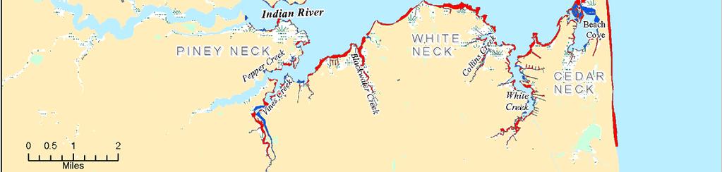
5 Study Area Rehoboth Bay is a shallow bar-built estuary with depths less than 6 to 7 ft (MLLW). Rehoboth Bay has tidal exchange through the southern link to Indian River Bay and through the Lewes Rehoboth Canal. It also receives freshwater inflow from the many tidal creeks. Six primary channel dredging projects within Rehoboth Bay: Lewes-Rehoboth Canal Love Creek Herring Creek Guinea Creek Wilson Creek Massey s Ditch

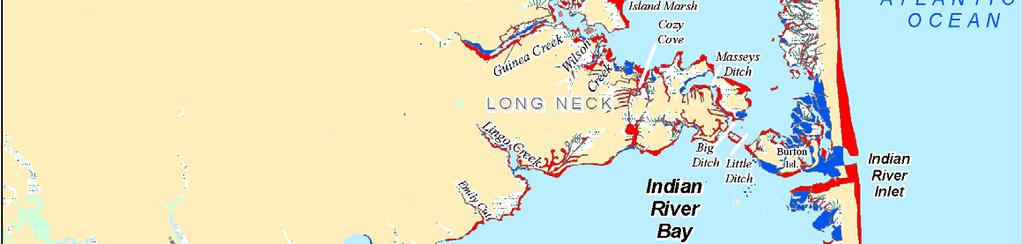
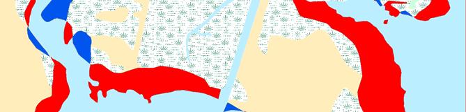
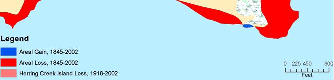
6 Shoreline Change


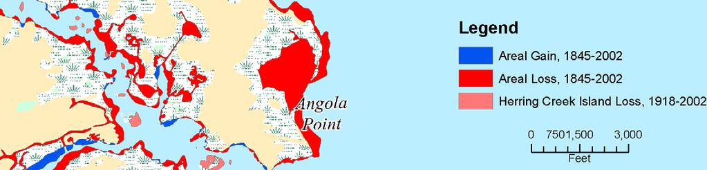
7 Western Shoreline

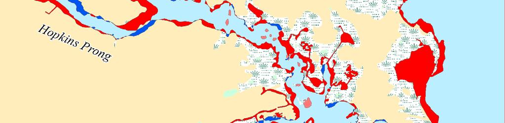
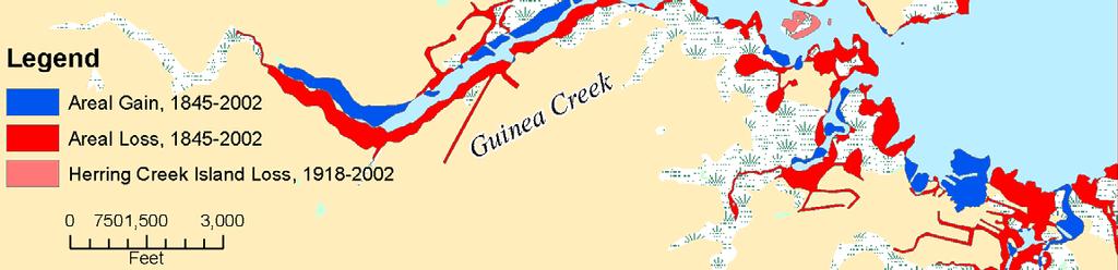
8 Herring Creek
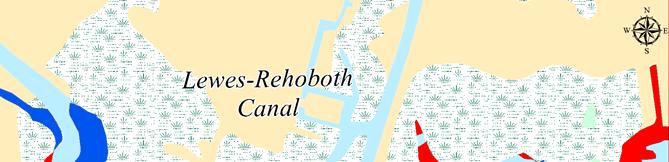
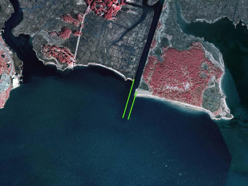
9 Lewes-Rehoboth Canal
10 Task 2. Historical Dredging and Disposal
11 USACE Dredging In recent years USACE has only maintained the L-R Canal north of the Savannah Ave Bridge Fiscal Year Job Name L & R CANAL - ROOSEV.INLET ROOSEVELT, MURDERKILL, MISPILLION IWW, REH. BAY TO DEL. BAY IWW, REH. BAY TO DEL. BAY ROOSEVELT INLET,DE. Dredge Type Pipeline Pipeline Pipeline Pipeline Pipeline Disposal Type Beach Nourishment Mixed (More than one type) Beach Nourishment Beach Nourishment and Upland Beach Nourishment Arrival Date Departure Date Volume Removed (CY) not avail not avail not avail 10/23/ /15/ ,873 10/28/ /30/ ,557 10/22/2001 3/1/ ,102 8/25/ /30/ ,745
12 DNREC Dredging since 1970 Decade Inland Bays Waterway Dredging (x1,000 cy) Other (x1,000 cy) Total (x1,000 cy) 1970's 's , 's 244 1,326 1, TOTAL 1,025 3,468 4,546
13 DNREC Dredging in Inland Bays WATERWAY YEAR TOTAL Initial Maint. Lewes-Rehoboth Canal 1989 TO Love Creek 1970 TO Herring Creek 1978 TO Guinea Creek Wilson Creek Cozy Cove 1978 TO Massey s Ditch 1987, 1990 TO Indian River Bay 91 TO 1992, 1995 TO 1996, Pepper Creek 1986 TO 1988, 1991 TO Vines Creek White Creek 970 TO 1971, 1997, 1999 TO Assawoman Canal Grand Total Navigation 1, Average Annual Maintenance 9.3
14 Task 3. Hydrodynamic Modeling
15 DELFT 3D Modeling System An integrated surface water modeling system developed by WL Delft Hydraulics Two and three-dimensional flow, waves, water quality, ecology, sediment transport and bottom morphology

16 Model Grid
17 Bathymetry Data Date Coverage Source 2004 IR Inlet and Surrounding areas USACE ,1970,1977, Inland Bays Offshore Love Creek Herring Creek Guinea Creek Bald Eagle Creek Roosevelt Inlet (Lewes Rehoboth Canal) DNREC NGDC (GEODAS) DNREC DNREC DNREC DNREC USACE
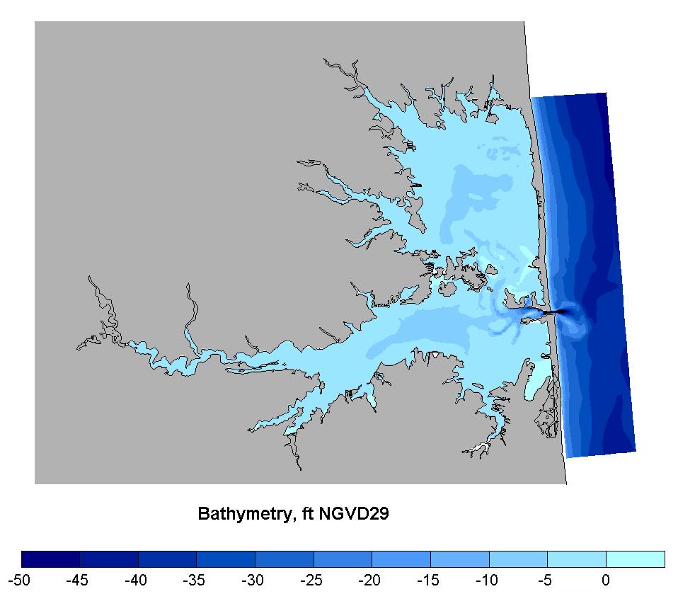
18 Model Bathymetry
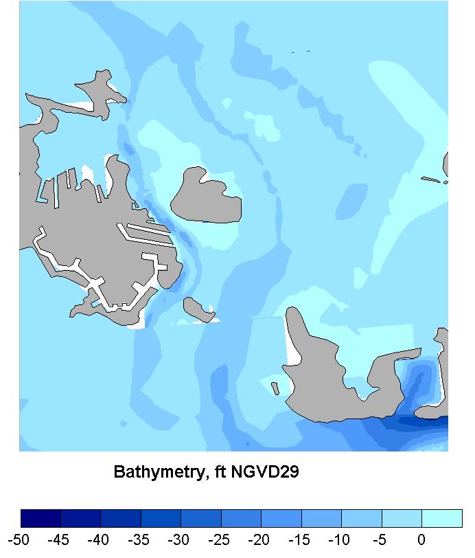
19 Model Bathymetry
20 Offshore Boundary Tidal constituents were extracted at the north and south ends of the boundary from the Advanced CIRCulation (ADCIRC) model EastCoast2001 Residuals from three nearby NOAA stations were compared with those at Indian River Inlet. Extracted residuals were added to the harmonic components of the boundary
21 Additional Forcing River Discharge was found to have negligible effects on hydrodynamic conditions with the exception of Indian River. Wind forcing has the greatest impact in Rehoboth Bay. The closest available source for the tested time periods was at Georgetown-Sussex Airport
22 Calibration
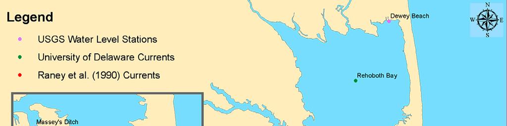
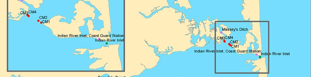
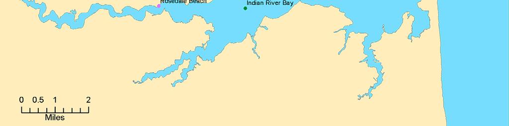
23 Harmonic Calibration 1 Elevation (ft) /01/02 05/08/02 05/15/02 05/22/02 05/29/02 Station Correlation RMS error (ft) Percent error Indian River Inlet (Coast Guard Station) Indian River Bay (Rosedale Beach) Rehoboth Bay (Dewey Beach) % % %
24 Water Level Calibration 4 Elevation (ft, NGVD29) /01/02 05/08/02 05/15/02 05/22/02 05/29/02 Station Correlation RMS error (ft) Percent error IRI (Coast Guard % Station) Indian River Bay % (Rosedale Beach) Rehoboth Bay (Dewey Beach) %

25 Water Levels

26 Water Levels
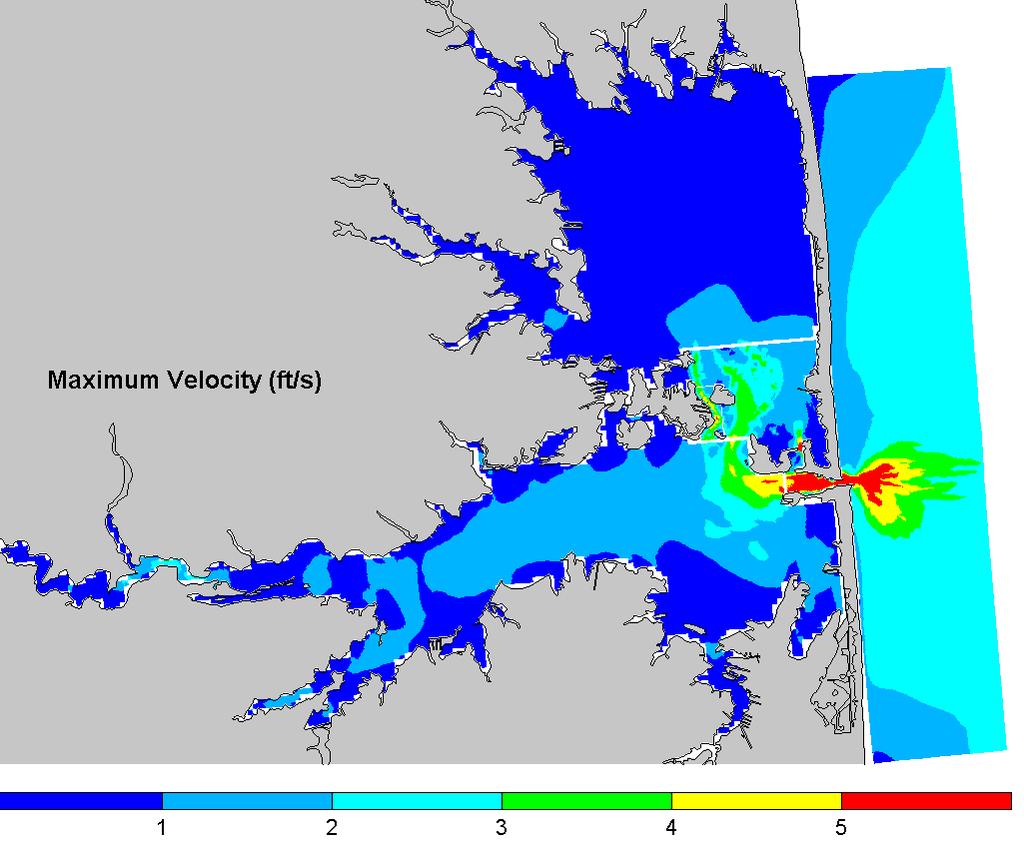
27 Maximum velocities
28 Task 4. Shoaling Calculations
 >90% sand")

29 Lewes-Rehoboth Canal Lewes Reach 5,000 to 10,000 cy/year (excluding RI inlet) >90% sand 2-4 yr cycle Most sedimentation occurs in the turning basin and bend immediately north of this area


30 Lewes-Rehoboth Canal Henlopen Acres Reach 1,000 to 2,000 cy/yr, 2-4 yr cycle. Less than 30% sand


31 Lewes-Rehoboth Canal Rehoboth Bridge 2,000 cy/yr, 2-4 yr cycle. More than 90% sand


32 Lewes-Rehoboth Canal Rehoboth Bay Jetties 4,000 cy/yr, 1-2 yr cycle. 50% sand 50% silt/clay Total initial volume for L-R Canal: 40,000 cy

33 Love Creek 3-5,000 cy/yr. Mostly silt/clay Total initial volume for -4 ft MLW channel: 60,000 cy

34 Herring and Guinea Creek 4-8,000 cy/yr for a channel at -4ft MLW. Mostly silt/clay

35 Massey s Ditch Problem Areas: A. North of Bluff Point B. Pullover C. Massey s Ditch D. Middle Island shoal E. Channel from Big Ditch to Little Ditch
36 Analytical Sedimentation Model Analytical methodology originally developed by Eysink and Vermaas (1983) which accounts for: Channel dimensions Natural water depth Settling velocity of sediment Estimated wave conditions Hydrodynamic model was modified to represent post-dredge conditions.

37 A. Bluff Point USACE Surveys

38 A. Bluff Point Maximum Velocity (ft/s)

39 B. Pullover USACE Surveys

")
40 B. Pullover Velocity (ft/s)

41 C. Massey s Landing USACE Surveys

")
42 C. Massey s Landing Velocity (ft/s)

43 D. Middle Island USACE Surveys

")
44 D. Middle Island Velocity (ft/s)

45 E. Big Ditch to Little Ditch Channel


46 E. Big Ditch to Little Ditch Channel Velocity (ft/s)
47 Massey s Ditch Shoaling Rates Location A: Bluff Point B: Pullover C: Massey s Landing D: Middle Island E: Big Ditch to Little Ditch Channel Shoaling Rate ft/yr (2) 1.8 Shoaling Rate cy/yr 8,000 3,000 3,000 8,000 2,000 Dredging frequency (1) (1) Approximate Dredging frequency required to maintain a channel at -6 ft MLW (2) This rate is not across the entire width of the channel, only at the leading edge of the shoal
48 Task 5. Sediment Management Alternatives
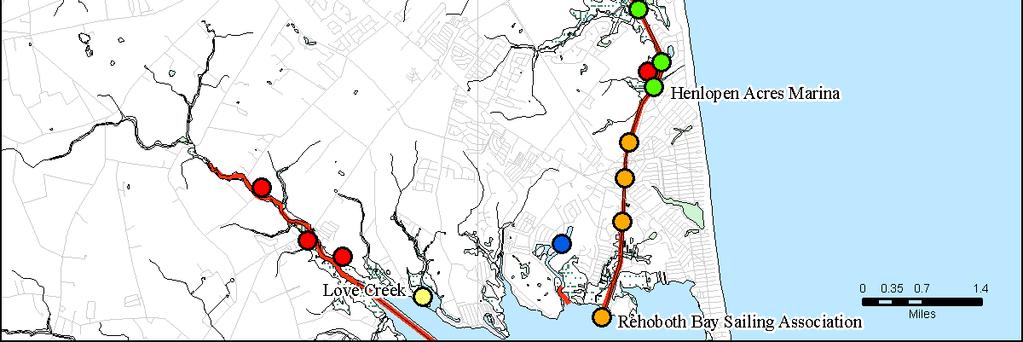
49 Shoaling Reduction Measures KSO: Keep Sediment Out Dikes Sills Harbor entrance modifications Sedimentation basins/traps KSM: Keep Sediment Moving Flow training structures Flow augmentation
50 Volume Reduction Measures Mechanical Dewatering: Belt Press Dredging Garrisons Lake near Smyrna (8,000 cy) Beneficial Reuse Measures Habitat Restoration & Development Wetlands (2,000 acres lost over last century) Thin Layer Spreading Aquatic Habitat Filling anoxic holes & dead en canals Island Restoration Beach Restoration

51 Camp Arrowhead
52 Lewes-Rehoboth Canal
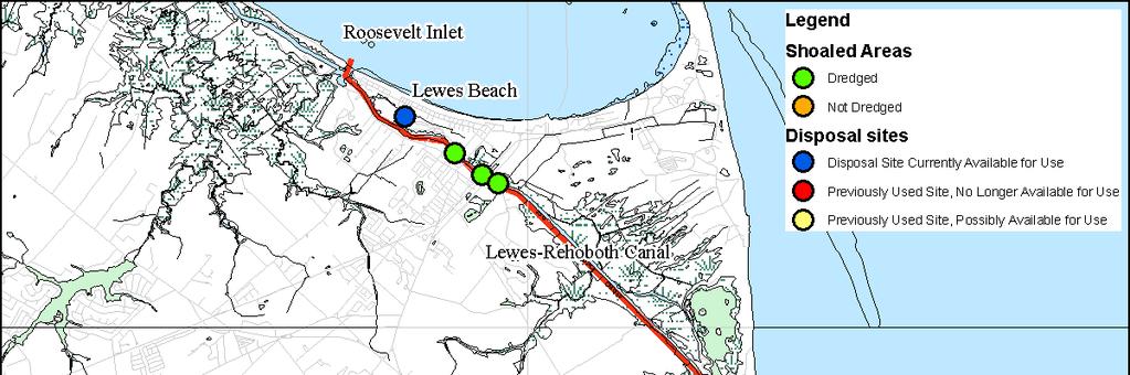
53 Lewes-Rehoboth Canal Projected Maintenance Dredging Volumes & Frequency Estimates are based on authorized project dimensions, including a channel depth of - 6 ft MLW. Lewes Reach: 5,000 to 10,000 cy/yr (RI not included). 2-4 year cycle. > 90% sand. Cape Henlopen State Park Reach: no dredging required. Henlopen Acres Reach: 1,000 to 2,000 cy/yr. 2-4 year cycle. < 30% sand. Rehoboth Beach Reach: 2,000 cy/yr. 2-4 year cycle. > 90% sand. Thompson Island Reach: 4,000 cy/yr. 1-2 year cycle. 50% sand and 50% silt/clay. Initial dredging volume likely to exceed 40,000 cy. Current Management & Issues Canal north of Savannah Ave Bridge last dredged by USACE in Disposal to Lewes CDF. The State dredged between Lewes and Henlopen Acres Marina in Disposal to two CDFs: City of Lewes and Mr. Andersen s Property across from Henlopen Acres. From Rehoboth Beach to the confluence with Rehoboth Bay the canal has not been dredged since the 1960 s. The State planned to dredge in this area but did not for lack of practical disposal options. Very limited federal funding available. USACE dredging unlikely south of RI
54 Potential SM Strategies Disposal Continued disposal to City of Lewes CDF for areas north Savannah Bridge KSM Removal of RR bridge abutment > Smoother flow conditions and increased exchange between Lewes and Rehoboth. Flow training wall at Henlopen Acres Marina Restoration of the Thompson Island Jetties No practical KSM elsewhere KSO Bank stabilization in Rehoboth.
55 Potential SM Strategies Beneficial Reuse Beach restoration at Lewes Marsh restoration on Thompson Island. Will likely require structural stabilization Thin-layer spraying Filling of anoxic holes in Bald Eagle Creek

56 Savannah Bridge

57 Henlopen Acres Marina

58 Thompson Island Marsh Restoration Thompson Island Terminal Structure Fill with dredged sediment Shoreline Protection Structure Existing Jetties Land loss since 1845 R e h o b o t h B a y

59 Low relief protection wall

60 Holt s Landing
61 Love Creek
62 Potential SM Strategies Disposal Exiting Robinson Landing site. Limited Capacity. 2 miles to the Rt 24 bridge KSM Channel marking: Boat traffic effects. KSO Not possible Beneficial Reuse Island restoration: Marsh and Big Piney, 5-10 acres. 1 mile to 3 miles. Will require containment and protection structures. Mainland marsh restoration (e.g., south of Joy Beach)

63 R E H O B O T H B A Y Horse Island Marsh Island Shoreline Protection Structure Fill with dredged sediment Big Piney Island Shoreline Protection Structure Unprotected containment Fill with dredged sediment

64 Herring & Guinea Creek
65 Potential SM Strategies Disposal Two areas possibly available: Shawns Hideaway & Winding Creek Village. Limited capacity KSM Channel marking. Expanded program into the Prongs and Guinea Creek KSO Not possible Beneficial Reuse Island restoration: Island in the Narrows. Mainland marsh restoration in the creek and along Long Neck Restoration at Joseph Lee Creek Filling of dead-end canals and ponds. Mouth of Joseph Lee Creek (Lingo Landing). Bayview Lane in Lingo Cove Thin-layer spreading

66 Wolfpit Marsh Angola Landing Herring Creek Guinea Creek Shoreline Protection Structure Unprotected containment Fill with dredged sediment Rehoboth Bay Wilson Marsh

67 Potential Marsh Restoration Area at Joseph Lee Creek

68 Lingo Cove

69 Massey s Ditch
70 Potential SM Strategies Disposal No disposal sites available in the immediate vicinity Bottom Hills Drain. 2 to 3 miles transport distance. 320,000 cy capacity. KSM Flow training features. Possibly in combination with marsh restoration KSO Not possible Beneficial Reuse Aquatic habitat restoration at BHD Marsh restoration Beach restoration: bay and ocean shorelines
71 Flow Training and fill containment structure Shoreline Protection Structure Fill with dredged sediment (typ.) Low relief containment structure (sill)
72 Flow Training and fill containment structure Shoreline Protection Structure Fill with dredged sediment (typ.) Rock groins

73 Angola Landing Restoration

74 Massey s to Middle Island D s y' se as M h itc Flow Training Wall Middle Island Big Ditch Little Ditch
75 THANK YOU!
Follets Island Nearshore Beach Nourishment Project
 Coast & Harbor Engineering A division of Hatch Mott MacDonald Follets Island Nearshore Beach Nourishment Project Arpit Agarwal, P.E. April 1, 2016 Project Site!"#$% &'(% &)*+% )#,'-+% Shoreline Erosion
APPENDIX M DREDGED MATERIAL MANAGEMENT PLAN (DMMP) FINAL INTEGRATED FEASIBILITY REPORT AND ENVIRONMENTAL ASSESSMENT
 FINAL INTEGRATED FEASIBILITY REPORT AND ENVIRONMENTAL ASSESSMENT") APPENDIX M DREDGED MATERIAL MANAGEMENT PLAN (DMMP) Brazos Island Harbor, Texas Channel Improvement Study FINAL INTEGRATED FEASIBILITY REPORT AND ENVIRONMENTAL ASSESSMENT This page is intentionally left
APPENDIX M DREDGED MATERIAL MANAGEMENT PLAN (DMMP) Brazos Island Harbor, Texas Channel Improvement Study FINAL INTEGRATED FEASIBILITY REPORT AND ENVIRONMENTAL ASSESSMENT This page is intentionally left
Nearshore Dredged Material Placement Pilot Study at Noyo Harbor, CA
 1 Nearshore Dredged Material Placement Pilot Study at Noyo Harbor, CA Noyo Cove N 2011 National Conference on Beach Preservation Technology 9-11, February 2011 Lihwa Lin, Honghai Li, Mitchell Brown US
Ninilchik Harbor Page 2 of 11
 Ninilchik Harbor Ninilchik Harbor Page 2 of 11 Condition of Improvements 31 December 2017 Ninilchik Harbor, Alaska (CWIS No. 012640, 087345) Authorization Rivers and Harbors Act, 3 July 1958 (P.L. 85-500
DELAWARE S VULNERABLE COASTAL AREAS. DELAWARE INLAND BAYS and DELAWARE BAY RECONNAISSANCE STUDY
 DELAWARE S VULNERABLE COASTAL AREAS and the DELAWARE INLAND BAYS and DELAWARE BAY RECONNAISSANCE STUDY Kimberly K. McKenna, PG Delaware Dept. of Natural Resources & Environmental Control Division of Watershed
Impact of Dredging the Lower Narrow River on Circulation and Flushing
 Impact of Dredging the Lower Narrow River on Circulation and Flushing Craig Swanson Ph.D. Swanson Environmental Alex Shaw Ocean Engineering, URI Prof. Malcolm L. Spaulding Ocean Engineering, URI 29 January
MOREHEAD CITY HARBOR, NC. Dredged Material Management Plan (DMMP)
") MOREHEAD CITY HARBOR, NC Dredged Material Management Plan (DMMP) Public Meeting/Info Session 15 January 2014 US Army Corps of Engineers Morehead City Harbor DMMP Presentation Topics Morehead City Harbor
MOREHEAD CITY HARBOR, NC Dredged Material Management Plan (DMMP) Public Meeting/Info Session 15 January 2014 US Army Corps of Engineers Morehead City Harbor DMMP Presentation Topics Morehead City Harbor
New Jersey Coastal Zone Overview. The New Jersey Beach Profile Network (NJBPN) 3 Dimensional Assessments. Quantifying Shoreline Migration
 3 Dimensional Assessments. Quantifying Shoreline Migration") New Jersey Coastal Zone Overview The New Jersey Beach Profile Network (NJBPN) Objectives Profile Locations Data Collection Analyzing NJBPN Data Examples 3 Dimensional Assessments Methodology Examples Quantifying
New Jersey Coastal Zone Overview The New Jersey Beach Profile Network (NJBPN) Objectives Profile Locations Data Collection Analyzing NJBPN Data Examples 3 Dimensional Assessments Methodology Examples Quantifying
Final Waterways Assets and Resources Survey Master Plan for Dredging and Beach Nourishment
 Final Waterways Assets and Resources Survey Master Plan for Dredging and Beach Nourishment For, Massachusetts Prepared For: Dennis Town Hall P.O. Box 2060 485 Main Street Dennis, MA 02660 Prepared By:
Sediment Transport Analysis Village of Asharoken, New York
 Sediment Transport Analysis Village of Asharoken, New York NORTH SHORE OF LONG ISLAND, NEW YORK COMBINED EROSION CONTROL AND STORM DAMAGE PROTECTION FEASIBILITY STUDY FINAL REPORT August 2004 Cell 0 Asharoken
CALCASIEU SALINITY STRUCTURES. HYDRODYNAMIC MODELING (To Support Design of Salinity Barriers)
") CALCASIEU SALINITY STRUCTURES HYDRODYNAMIC MODELING (To Support Design of Salinity Barriers) Presentation Overview 1 2 3 4 5 Project Overview and CEA Circulation Modeling Vessel Hydrodynamics Modeling
CALCASIEU SALINITY STRUCTURES HYDRODYNAMIC MODELING (To Support Design of Salinity Barriers) Presentation Overview 1 2 3 4 5 Project Overview and CEA Circulation Modeling Vessel Hydrodynamics Modeling
APPENDIX C. Fluvial and Tidal Hydraulics Report
 APPENDIX C Fluvial and Tidal Hydraulics Report BUENA VISTA LAGOON ENHANCEMENT PROJECT FLUVIAL AND TIDAL HYDRAULICS ANALYSES Prepared for: SANDAG 401 B Street, Suite 800 San Diego, California 92101 Contact:
Coastal Harbors and Waterways, NC (Shallow Draft Navigation) (O&M)
 (O&M)") Coastal Harbors and Waterways, NC (Shallow Draft Navigation) (O&M) Shallow draft coastal harbors include a subsistence harbor at Silver Lake CONGRESSIONAL DISTRICT: NC 3 and 7 DATE: 23 February 2015 1.
Coastal Harbors and Waterways, NC (Shallow Draft Navigation) (O&M) Shallow draft coastal harbors include a subsistence harbor at Silver Lake CONGRESSIONAL DISTRICT: NC 3 and 7 DATE: 23 February 2015 1.
Evaluation of Placement Alternatives for Matagorda Ship Channel Bottleneck Removal
 Evaluation of Placement Alternatives for Matagorda Ship Channel Bottleneck Removal James Rosati III Ashley E. Frey CPT Grays Harbor, WA Wood Wood chips Flour Other CMS Shark River Inlet, NJ US Army Corps
X.B WETLANDS ROGUE RIVER ESTUARY
 X.B WETLANDS ROGUE RIVER ESTUARY The Rogue River has a drainage area of 5,100 square miles, yet the estuary of the Rogue River is one of the smallest in Oregon, measuring approximately 1,880 acres during
TOWN OF DENNIS 10 YR COMPREHENSIVE DREDGE PERMIT SEPTEMBER 10, 2013
 TOWN OF DENNIS 10 YR COMPREHENSIVE DREDGE PERMIT SEPTEMBER 10, 2013 WHAT IS IT? ALL NECESSARY PERMITS FOR DREDGING FOR PORTIONS OF BASS RIVER, SWAN POND RIVER, SESUIT HARBOR AND CHASE GARDEN CREEK ONE
SHORE PROTECTION AND HABITAT CREATION AT SHAMROCK ISLAND, TEXAS ABSTRACT
 SHORE PROTECTION AND HABITAT CREATION AT SHAMROCK ISLAND, TEXAS M. Cameron Perry, P.E., and Daniel J. Heilman, P.E. Coastal Engineer Shiner Moseley & Associates., Inc. 555 N. Carancahua Corpus Christi,
Coastal Harbors and Waterways, NC (Shallow Draft Navigation) (O&M)
 (O&M)") Coastal Harbors and Waterways, NC (Shallow Draft Navigation) (O&M) Shallow draft coastal harbors include a subsistence harbor at Silver Lake CONGRESSIONAL DISTRICT: NC 3, 7 DATE: 23 April 2018 1. AUTHORIZATION:
Coastal Harbors and Waterways, NC (Shallow Draft Navigation) (O&M) Shallow draft coastal harbors include a subsistence harbor at Silver Lake CONGRESSIONAL DISTRICT: NC 3, 7 DATE: 23 April 2018 1. AUTHORIZATION:
Inlet Management Study for Pass-A-Grille and Bunces Pass, Pinellas County, Florida
 Inlet Management Study for Pass-A-Grille and Bunces Pass, Pinellas County, Florida Final Report Submitted By Ping Wang, Ph.D., Jun Cheng Ph.D., Zachary Westfall, and Mathieu Vallee Coastal Research Laboratory
NAVIGATION STUDY FOR LAKE WORTH INLET, FLORIDA DRAFT INTEGRATED FEASIBILITY REPORT AND ENVIRONMENTAL IMPACT STATEMENT APPENDIX A ENGINEERING
 NAVIGATION STUDY FOR LAKE WORTH INLET, FLORIDA DRAFT INTEGRATED FEASIBILITY REPORT AND ENVIRONMENTAL IMPACT STATEMENT APPENDIX A ENGINEERING NAVIGATION STUDY FOR LAKE WORTH INLET, FLORIDA DRAFT INTEGRATED
Nome Harbor Page 2 of 12
 Nome Harbor Nome Harbor Page 2 of 12 Condition of Improvements 30 December 2015 Nome Harbor, Alaska (CWIS No. 010422, 012270, 072742, 087755) Authorization (1) Rivers and Harbors Act, 8 August 1917 (House
Effect of Hydrodynamics on Sediment Transport near a Coastal Inlet
 ICHE 2014, Hamburg - Lehfeldt & Kopmann (eds) - 2014 Bundesanstalt für Wasserbau ISBN 978-3-939230-32-8 Effect of Hydrodynamics on Sediment Transport near a Coastal Inlet H. Li, M. Brown, J. Rosati & Z.
DEAD-ENDCHANNELFLUSHINGINHARBORS
 DEAD-ENDCHANNELFLUSHNGNHARBORS PURPOSE: The purpose of this technical note is to present some design con- siderations which benefit dead-end channel flushing. Some of these factors can also be used to
North Shore of Long Island, Feasibility Study
 North Shore of Long Island, Asharoken New York Asharoken, Feasibility Study Asharoken, NY Public Meeting June 30, 2015 US Army Corps of Engineers US Army Corps of Engineers New York BUILDING STRONG BUILDING
Water Resources Report RKLD Annual Meeting July 30, 2016
 Water Resources Report RKLD Annual Meeting 2016 July 30, 2016 Topics Hydrology Report Indianford Dam trash rack cleanout performance Experimental Project update Review of PAS project Twin floods- 1 to
EVALUATION OF BEACH EROSION UP-DRIFT OF TIDAL INLETS IN SOUTHWEST AND CENTRAL FLORIDA, USA. Mohamed A. Dabees 1 and Brett D.
 EVALUATION OF BEACH EROSION UP-DRIFT OF TIDAL INLETS IN SOUTHWEST AND CENTRAL FLORIDA, USA Mohamed A. Dabees 1 and Brett D. Moore 1 The paper discusses the analysis of up-drift beach erosion near selected
BOLSA CHICA WETLANDS RESTORATION INLET DESIGN. Weixia Jin 1 and Michael McCarthy 1
 BOLSA CHICA WETLANDS RESTORATION INLET DESIGN Weixia Jin 1 and Michael McCarthy 1 Bolsa Chica Wetlands is one of a few recently restored large wetlands in Southern California of the United States. The
APPENDIX D W-19 FLUVIAL AND TIDAL HYDRAULIC, SEDIMENTATION, WATER QUALITY AND SEA LEVEL RISE MODELING STUDIES
 APPENDIX D W-19 FLUVIAL AND TIDAL HYDRAULIC, SEDIMENTATION, WATER QUALITY AND SEA LEVEL RISE MODELING STUDIES Final EIR November 2018 Appendices Executive Summary Background: The San Dieguito Lagoon W19
Hydrodynamic Modeling of Tides and Hurricane Storm Surge for Pre- and Post-Dredging Conditions in the Lower St. Johns River, Florida
 Hydrodynamic Modeling of Tides and Hurricane Storm Surge for Pre- and Post-Dredging Conditions in the Lower St. Johns River, Florida Matthew V. Bilskie 1 1 PhD Student, University of Central Florida, Department
Coastal Environments Oceanographic and Engineering Expertise
 Coastal Environments Oceanographic and Engineering Expertise Coastal Environments La Jolla, CA www.coastalenvironments.com 14 May 2004 CE Ref. No. 04-05 EcoSystems Management Associates, Inc. Carlsbad,
COUPLED MANAGEMENT STRATEGY LAKE CATHIE ESTUARY & COAST
 Lake Cathie Progress Association Inc. ABN 28 251 433 854 P.O. Box 247 Lake Cathie NSW 2445 PHONE/FAX: 02 6584 8211 EMAIL: r3packag@bigpond.com 20 th October 2009 Port Macquarie Hastings Council PO Box
1-32 NOME HARBOR, ALASKA (CWIS NOS , 87755, 12270, & 10422) Condition of Improvement 30 September 2012
 Condition of Improvement 30 September 2012") NOME HARBOR 1-32 NOME HARBOR, ALASKA (CWIS NOS. 72742, 87755, 12270, & 10422) Condition of Improvement 30 September 2012 AUTHORIZATION: (1) Rivers and Harbors Act, 8 August 1917 (House Doc. 1932, 64th
NOME HARBOR 1-32 NOME HARBOR, ALASKA (CWIS NOS. 72742, 87755, 12270, & 10422) Condition of Improvement 30 September 2012 AUTHORIZATION: (1) Rivers and Harbors Act, 8 August 1917 (House Doc. 1932, 64th
Assateague Island National Seashore North End Restoration Project Timeline
 Assateague Island National Seashore North End Restoration Project Timeline Date Event Some information provided in the Project Introduction document. Detailed events are available in a timeline compiled
RE: Hurricane Matthew Beach Damage Assessment and Recommendations [CSE 2416]
![RE: Hurricane Matthew Beach Damage Assessment and Recommendations [CSE 2416]](/thumbs/83/87675702.jpg "RE: Hurricane Matthew Beach Damage Assessment and Recommendations [CSE 2416]") October 25, 2016 Iris Hill Town Administrator Town of Edisto Beach 2414 Murray St Edisto Beach SC 29438 RE: Hurricane Matthew Beach Damage Assessment and Recommendations [CSE 2416] Dear Iris, Hurricane
October 25, 2016 Iris Hill Town Administrator Town of Edisto Beach 2414 Murray St Edisto Beach SC 29438 RE: Hurricane Matthew Beach Damage Assessment and Recommendations [CSE 2416] Dear Iris, Hurricane
Beach Nourishment Impact on Beach Safety and Surfing in the North Reach of Brevard County, Florida
 Beach Nourishment Impact on Beach Safety and Surfing in the North Reach of Brevard County, Florida Prepared by John Hearin, Ph.D. Coastal Engineering Vice Chairman Cocoa Beach Chapter Port Canaveral Patrick
1-44. SITKA HARBOR, ALASKA (Western Channel, Crescent Bay Basin, Channel Rock Breakwaters) (CWIS NOS , 16840, 10322, 55030, 13787)
 (CWIS NOS , 16840, 10322, 55030, 13787)") SITKA 1-44 SITKA HARBOR, ALASKA (Western Channel, Crescent Bay Basin, Channel Rock Breakwaters) (CWIS NOS. 72845, 16840, 10322, 55030, 13787) Condition of Improvement 30 September 2011 AUTHORIZATION:
SITKA 1-44 SITKA HARBOR, ALASKA (Western Channel, Crescent Bay Basin, Channel Rock Breakwaters) (CWIS NOS. 72845, 16840, 10322, 55030, 13787) Condition of Improvement 30 September 2011 AUTHORIZATION:
BALD HEAD ISLAND, NC SAND SHARING SYSTEM OVERVIEW AND ASSESSMENT. Erik J. Olsen, P.E. olsen associates, inc.
 BALD HEAD ISLAND, NC SAND SHARING SYSTEM OVERVIEW AND ASSESSMENT Erik J. Olsen, P.E. Olsen Associates, Inc. BACKGROUND Both the Village of Bald Head Island (VBHI) and the Bald Head Island Limited, LLC.
ABSTRACT. KEY WORDS: Navigation safety; numerical modeling; waves; current; sediment transport; channel infilling; morphology change.
 The 25th (2015) International Polar and Engineering Conference Li, H., L. Lin, Z. Demirbilek, T. M. Beck, and H. R. Moritz (2015). Wave-Current Conditions and Navigation Safety at an Inlet Entrance. The
100-YEARS OF SHOAL EVOLUTION AT THE MOUTH OF THE COLUMBIA RIVER: IMPACTS ON CHANNEL, STRUCTURES, AND SHORELINES
 100-YEARS OF SHOAL EVOLUTION AT THE MOUTH OF THE COLUMBIA RIVER: IMPACTS ON CHANNEL, STRUCTURES, AND SHORELINES Hans R. Moritz, 1 Heidi P. Moritz, 2 Jessica R. Hays, 3 and Heather R. Sumerell 4 Abstract:
GONE! Coastal Erosion Happens During Storms! Why Worry About Coastal Setbacks? Goals for Today
 RI Regulatory Setbacks & Buffers: Coastal Zone Management Issues New England Onsite Wastewater Training Program @ URI OWT 155 November 21, 2013 Goals for Today Understand the impacts of storms, coastal
Response of a Newly Created Marsh-Wetland Affected by Tidal Forcing, Upland Discharge, and Groundwater Interaction
 Response of a Newly Created Marsh-Wetland Affected by Tidal Forcing, Upland Discharge, and Groundwater Interaction Mouth of Columbia River, Cape Disappointment State Park, Washington 12 Hans R. Moritz
Feasibility Study for Restoration of Titlow Lagoon Fish Passage. South Puget Sound Salmon Enhancement Group
 Feasibility Study for Restoration of Titlow Lagoon Fish Passage South Puget Sound Salmon Enhancement Group January 2010 Feasibility Study for Restoration of Titlow Lagoon Fish Passage Prepared for South
Salt Ponds Shore Zone Modeling for Breakwater Placement: Summary Report
 Salt Ponds Shore Zone Modeling for Breakwater Placement: Summary Report Virginia Institute of Marine Science May 2014 Salt Ponds Shore Zone Modeling for Breakwater Placement: Summary Report For Waterway
Building Coastal Resiliency at Plymouth Long Beach
 Building Coastal Resiliency at Plymouth Long Beach Department of Marine and Environmental Affairs March 30, 2017 Introducing Green Infrastructure for Coastal Resiliency Plymouth Long Beach & Warren s Cove
Figure 4, Photo mosaic taken on February 14 about an hour before sunset near low tide.
 The Impact on Great South Bay of the Breach at Old Inlet Charles N. Flagg and Roger Flood School of Marine and Atmospheric Sciences, Stony Brook University Since the last report was issued on January 31
RI Regulatory Setbacks & Buffers: Coastal Management Issues
 RI Regulatory Setbacks & Buffers: Coastal Management Issues New England Onsite Wastewater Training Program @ URI OWT 155 - November 29, 2012 James Boyd - Coastal Policy Analyst Photo: October 30, 2012
Controlling Coastal erosion
 Controlling Coastal erosion Coastal Erosion Rates in the U.S. Coastal Erosion and Stabilization Economic pressures demanding the stabilization of beaches and coastlines are immense Coastal Erosion and
Condition of Improvements 30 December 2014 Wrangell Harbors, Alaska (CWIS No , )
") Wrangell Harbors Condition of Improvements 30 December 2014 Wrangell Harbors, Alaska (CWIS No. 010435, 021500) Authorization (1) Rivers and Harbors Act, 22 September 1922 (House Doc. 161, 67th Congress,
Wrangell Harbors Condition of Improvements 30 December 2014 Wrangell Harbors, Alaska (CWIS No. 010435, 021500) Authorization (1) Rivers and Harbors Act, 22 September 1922 (House Doc. 161, 67th Congress,
Shoreline Change in Response to Sea Level Rise on Florida s Panhandle Coast. Jim Houston `
 Shoreline Change in Response to Sea Level Rise on Florida s Panhandle Coast Jim Houston james.r.houston @usace.army.mil ` Approach Calculate historical shoreline change by county (1867-2015) Determine
Cordova Harbor Page 2 of 9
 Cordova Harbor Cordova Harbor Page 2 of 9 Condition of Improvements 30 December 2017 Cordova Harbor, Alaska (CWIS No. 087136, 087186, 087711) Authorization Rivers and Harbors Act, 30 August 1935 (R & H
DUXBURY WAVE MODELING STUDY
 DUXBURY WAVE MODELING STUDY 2008 Status Report Duncan M. FitzGerald Peter S. Rosen Boston University Northeaster University Boston, MA 02215 Boston, MA 02115 Submitted to: DUXBURY BEACH RESERVATION November
STORM RESPONSE SIMULATION
 APPENDIX V STORM RESPONSE SIMULATION Final Environmental Impact Statement Village of Bald Head Island Shoreline Protection Project Brunswick County, North Carolina Delft3D Storm Response Simulations With
Wexford Harbour. Yachting Guide. Navigation
 Wexford Harbour Yachting Guide Navigation This document supersedes all previous editions. Approvals: Yacht Club Committee April, 2015 Wexford Board of Directors April, 2015 # Date Section Revision 1 6.5.2015
HURRICANE SANDY LIMITED REEVALUATION REPORT UNION BEACH, NEW JERSEY DRAFT ENGINEERING APPENDIX SUB APPENDIX D SBEACH MODELING
 HURRICANE SANDY LIMITED REEVALUATION REPORT UNION BEACH, NEW JERSEY DRAFT ENGINEERING APPENDIX SUB APPENDIX D SBEACH MODELING Rev. 18 Feb 2015 1 SBEACH Modeling 1.0 Introduction Following the methodology
CORPS ON THE COAST. North Carolina Coastal Conference Coastal Infrastructure Raleigh, NC April 14, Jim Medlock Chief, Programs Management Branch
 CORPS ON THE COAST North Carolina Coastal Conference Coastal Infrastructure Raleigh, NC April 14, 2015 Jim Medlock Chief, Programs Management Branch US Army Corps of Engineers OVERVIEW What Are The Corps
Wave Energy Research and Applications
 Wave Energy Research and Applications Shoreline and Shallows conference East Lansing, MI March 7, 2019 Photo: Dave Sanford Waves Background 1. Types of Waves 2. Good and Bad Waves 3. Restoration Impacts
DUNE STABILIZATION AND BEACH EROSION
 DUNE STABILIZATION AND BEACH EROSION CAPE HATTERAS NATIONAL SEASHORE NORTH CAROLINA ROBERT DOLAN PAUL GODFREY U. S. DEPARTMENT OF INTERIOR NATIONAL PARK SERVICE OFFICE OF NATURAL SCIENCE WASHINGTON, D.
SOUTH LAKE WORTH INLET: INLET MODIFICATION FEASIBILITY STUDY
 ABSTRACT SOUTH LAKE WORTH INLET: INLET MODIFICATION FEASIBILITY STUDY John Duchock, P.E., Project Engineer Michael Jenkins, PhD., P.E., Coastal Engineering Team Leader Applied Technology & Management,
3.3 OCEANOGRAPHY/COASTAL PROCESSES
 3.3 OCEANOGRAPHY/COASTAL PROCESSES Beaches are dynamic and conditions vary based on the onshore/offshore movement of sand both seasonally and annually. Sand also moves alongshore within a generally defined
CHAPTER 134 INTRODUCTION
 CHAPTER 134 NEW JETTIES FOR TUNG-KANG FISHING HARBOR, TAIWAN Chi-Fu Su Manager Engineering Department Taiwan Fisheries Consultants, Inc. Taipei, Taiwan INTRODUCTION Tung-Kang Fishing Harbor, which is about
For more information or permission to reprint slides, please contact Donna Milligan at 1
 For more information or permission to reprint slides, please contact Donna Milligan at milligan@vims.edu 1 For more information or permission to reprint slides, please contact Donna Milligan at milligan@vims.edu
Planning Considerations for Nearshore Placement of Mixed Dredged Sediments
 Planning Considerations for Nearshore Placement of Mixed Dredged Sediments PURPOSE: Dredging planning and management decisions are based on a combination of engineering and economic factors tempered by
Regular Workshop October 20, 2014 Agenda Item: Dr. Albert E. Browder, PE; Olsen Associates, Inc.
 Regular Workshop October 20, 2014 Agenda Item 8 Agenda Item: Presenter: Summary: Beach Update Town Manager; Dr. Albert E. Browder, PE; Olsen Associates, Inc. At the January 21, 2014 Regular Workshop Meeting,
Cline s Point Marina Ship Wave Analysis
 Cline s Point Marina Ship Wave Analysis Draft Technical Report April 13, 2015 Submitted To: Port of Corpus Christi Authority Prepared for: Port of Corpus Christi Authority This document is intended for
Conservation and Restoration Florida s Coastal Marshes: An Overview of MESS. Jeff Beal, Kent Smith, Erin McDevitt, Maria Merrill
 Conservation and Restoration Florida s Coastal Marshes: An Overview of MESS Jeff Beal, Kent Smith, Erin McDevitt, Maria Merrill FWC s MESS: -Marine/Estuarine Subsection -within Aquatic Habitat Conservation
PLAQUEMINES PARISH BARRIER ISLAND RESTORATION & SUSTAINABILITY. MVD/Gulf Coast Regional Dredging Meeting November 5, 2013
 PLAQUEMINES PARISH BARRIER ISLAND RESTORATION & SUSTAINABILITY MVD/Gulf Coast Regional Dredging Meeting November 5, 2013 OVERVIEW 1. Barrier Island Restoration Projects in Plaquemines Parish 2. Plaquemines
CORPS FACTS. Harbor Dredging U.S. ARMY CORPS OF ENGINEERS BUILDING STRONG
 CORPS FACTS Harbor Dredging U.S. ARMY CORPS OF ENGINEERS BUILDING STRONG Disaster Response Sedimentation in the channel is caused by the normal cycle of silt movement, erosion from high water or heavy
page - Laboratory Exercise #5 Shoreline Processes
 page - Laboratory Exercise #5 Shoreline Processes Section A Shoreline Processes: Overview of Waves The ocean s surface is influenced by three types of motion (waves, tides and surface currents). Shorelines
Dredged Material Management Plan Atlantic Intracoastal Waterway Port Royal Sound, South Carolina to Cumberland Sound, Georgia November 2015
 Dredged Material Management Plan Atlantic Intracoastal Waterway Port Royal Sound, South Carolina to Cumberland Sound, Georgia November 2015 Appendix B: Biological Assessment of Threatened and Endangered
Impacts of breakwaters and training walls
 Across the eastern seaboard of Australia, breakwaters and training walls have instigated fundamental perturbations to coastal and estuary processes. This has induced long-term changes to foreshore alignments,
Nearshore Sediment Transport What influences the loss of sediment on Beaches? - Waves - Winds - Tidal Currents - River discharge - Runoff
 Tides & Beaches Nearshore Sediment Transport What influences the loss of sediment on Beaches? - Waves - Winds - Tidal Currents - River discharge - Runoff Oceans Ocean Topography Physical Structure of the
SACO RIVER AND CAMP ELLIS BEACH SACO, MAINE SECTION 111 SHORE DAMAGE MITIGATION PROJECT APPENDIX F ECONOMIC ASSESSMENT
 SACO RIVER AND CAMP ELLIS BEACH SACO, MAINE SECTION 111 SHORE DAMAGE MITIGATION PROJECT APPENDIX F ECONOMIC ASSESSMENT Department of the Army New England District, Corps of Engineers 696 Virginia Road
VIMS CCRM Coastal Management Decision Tools. Decision Tree for Undefended Shorelines and Those with Failed Structures
 VIMS CCRM Coastal Management Decision Tools Decision Tree for Undefended Shorelines and Those with Failed Structures Center for Coastal Resources Management Virginia Institute of Marine Science Gloucester
Modeling Sediment Transport Along the Upper Texas Coast
 Modeling Sediment Transport Along the Upper Texas Coast David B. King Jr. Jeffery P. Waters William R. Curtis Highway 87 roadbed, Jefferson County Galveston District Corps Sabine Pass to San Luis Pass
Appendix G Applied Coastal Pipeline Impact Assessment
 Appendix G Applied Coastal Pipeline Impact Assessment Simulating the Potential Impact of Borrow Site Excavation on Sediment Transport Along the Gulfstream Pipeline, Petit Bois Pass, Alabama Prepared for:
OYSTER REEF RESTORATION; RESTORING ECOLOGICAL FUNCTION
 OYSTER REEF RESTORATION; RESTORING ECOLOGICAL FUNCTION Paul Jensen, David Buzan, and Ka-Leung Lee; Atkins Mark Dumesnil and Julie Sullivan; The Nature Conservancy Presentation Overview The Nature Conservancy
LAB: WHERE S THE BEACH
 Name: LAB: WHERE S THE BEACH Introduction When you build a sandcastle on the beach, you don't expect it to last forever. You spread out your towel to sunbathe, but you know you can't stay in the same spot
Puget Sound Nearshore Ecosystem Restoration Project Restore America s Estuaries Conference 2012 Tampa, FL
 Restore America s Estuaries Conference 2012 Tampa, FL presented by: Theresa Mitchell, WA Dept. of Fish & Wildlife Nearshore General Investigation Change Analysis: Comparison of historical and current
GenCade Applications Ashley Frey
 GenCade Applications Ashley Frey Research Civil Engineer, Co-PI of the Inlet Engineering Toolbox work unit of CIRP Report Documentation Page Form Approved OMB No. 0704-0188 Public reporting burden for
Mouth of the Columbia River Jetties Three-Phase Construction Plan
 Mouth of the Columbia River Jetties Three-Phase Construction Plan Project Overview October 9, 2012 US Army Corps of Engineers MCR Jetties Major Rehabilitation Sand Island pile dikes 1930-1935 Columbia
KEYNOTE PRESENTATION FSBPA olsen
 AMELIA ISAND, FLORIDA BEACH MANAGEMENT PARTNERING AND PERSERVERENCE Erik Olsen, PE associates, inc. KEYNOTE PRESENTATION FSBPA 2009 IN ORDER TO ADDRESS SHORE PROTECTION TODAY LOCAL INTERESTS PARTNER WITH:
Coastal Sediment Transport Modeling Ocean Beach & San Francisco Bight, CA
 1 Coastal Sediment Transport Modeling Ocean Beach & San Francisco Bight, CA Honghai Li and Lihwa Lin Engineering Research and Development Center U.S. Army Corps of Engineers Frank Wu, Lisa Andes, and James
INDIANA REGIONAL GENERAL CONDITIONS FOR THE STATE OF INDIANA
 INDIANA REGIONAL GENERAL CONDITIONS FOR THE STATE OF INDIANA These regional conditions are in addition to but do not supersede the requirements in the Federal Register (Volume 82 No. 4 of January 6, 2017).
CRC Inlet Management Study. Matt Slagel Shoreline Management Specialist
 CRC Inlet Management Study Matt Slagel Shoreline Management Specialist Study Origin CRC shall study feasibility of creating new AEC for lands adjacent to mouth of Cape Fear River (HB 819) Collaborate with
Chapter 6: Santander case
 6 Santander case 6.1 Introduction Port activity in Santander dates back more than 2,000 years ago. Throughout this period, the sea and the port have been the fundamental elements of a community which,
Maltester Channel Dredging. Shoreline Marina Committee. November 18, 2008
 Maltester Channel Dredging Shoreline Marina Committee November 18, 2008 Shoaling Study Summary Report Completed in October 2008 Analyzed siltation rates at Marina Rate of siltation is dynamic ranging from
Volume and Shoreline Changes along Pinellas County Beaches during Tropical Storm Debby
 Volume and Shoreline Changes along Pinellas County Beaches during Tropical Storm Debby Ping Wang and Tiffany M. Roberts Coastal Research Laboratory University of South Florida July 24, 2012 Introduction
Tanya M. Beck. Kelly Legault. Research Physical Scientist Coastal & Hydraulics Lab, ERDC Vicksburg, MS
 Inlet And Adjacent Shoreline Processes at Cascading Time Scales Using the Coastal Modeling System and GenCade Tanya M. Beck Research Physical Scientist Coastal & Hydraulics Lab, ERDC Vicksburg, MS Kelly
Coastal Harbors and Waterways, NC (Shallow Draft Navigation) (O&M)
 (O&M)") Coastal Harbors and Waterways, NC (Shallow Draft Navigation) (O&M) Shallow draft coastal harbors include a subsistence harbor at Silver Lake CONGRESSIONAL DISTRICT: NC 3 and 7 DATE: 23 February 2015 1.
Coastal Harbors and Waterways, NC (Shallow Draft Navigation) (O&M) Shallow draft coastal harbors include a subsistence harbor at Silver Lake CONGRESSIONAL DISTRICT: NC 3 and 7 DATE: 23 February 2015 1.
The Continuing Evolution of the New Inlet
 The Continuing Evolution of the New Inlet Charles N. Flagg, Roger Flood and Robert Wilson School of Marine and Atmospheric Sciences, Stony Brook University It is now a year plus since super storm Sandy
CROSS-SHORE SEDIMENT PROCESSES
 The University of the West Indies Organization of American States PROFESSIONAL DEVELOPMENT PROGRAMME: COASTAL INFRASTRUCTURE DESIGN, CONSTRUCTION AND MAINTENANCE A COURSE IN COASTAL DEFENSE SYSTEMS I CHAPTER
Summary of Water Access for Marinas and Public Boat Ramps
 Lake Tahoe Shoreline Plan Meeting Materials: Steering Committee Last Updated: 11-28-16 Summary of Water Access for Marinas and Public Boat Ramps Table 1: Marinas Buoy Field Assessment Marinas 1. North
ST. JOSEPH PENINSULA, GULF COUNTY, FLORIDA Beach Re-Nourishment and Environmental Enhancement Project RECOMMENDATIONS
 ST. JOSEPH PENINSULA, GULF COUNTY, FLORIDA Beach Re-Nourishment and Environmental Enhancement Project RECOMMENDATIONS January 23, 2018 543 Harbor Boulevard, Suite 204 Destin, Florida 32541 850.654.1555
3.9 Marine Transportation
 3.9 Marine Transportation 3. Affected Environment and Environmental Analysis 3.9 Marine Transportation 3.9.1 Introduction This section describes existing marine vessel transportation within the Port, the
Shoreline Studies Program, Department of Physical Sciences, VIMS
 Living Shoreline Training Class 2017 1 Demonstration sites discussed in this talk. 2 A shoreline management plan for the entire creek made conceptual shoreline management recommendations along every stretch
LITTLE LAGOON & LITTLE LAGOON PASS: RESEARCH UPDATES & DIRECTIONS
 LITTLE LAGOON & LITTLE LAGOON PASS: RESEARCH UPDATES & DIRECTIONS Bret M. Webb, PhD, PE, DCE Professor Department of Civil, Coastal, and Environmental Engineering October 19, 2017 LLPS Meeting Acknowledgments
HABITAT RESTORATION USING DREDGED MATERIAL PLACEMENT
 HABITAT RESTORATION USING DREDGED MATERIAL PLACEMENT WITHIN THE LOWER COLUMBIA RIVER AT WOODLAND ISLANDS, WA 237 237 237 217 217 217 200 200 200 Hans Moritz Matt Fraver Logan Negherbon 255 0 163 131 Mike
2018 Annual Beach Monitoring Report
 May 1, 218 Town of Hilton Head Island, SC 218 Annual Beach Monitoring Report Submitted to: Town of Hilton Head Island, SC November 15, 217 Prepared by: Olsen Associates, Inc. 2618 Herschel Street Jacksonville,
PEASE DEVELOPMENT AUTHORITY DIVISION OF PORTS & HARBORS ANNUAL DREDGE REPORT
 PEASE DEVELOPMENT AUTHORITY DIVISION OF PORTS & HARBORS ANNUAL DREDGE REPORT 2018 555 Market Street Portsmouth, New Hampshire 03801 Phone #603 436 8500 Fax #603 436 2780 TABLE OF CONTENTS Cover Page Table
CLAM PASS RESTORATION AND MANAGEMENT PLAN BATHYMETRIC MONITORING REPORT NO. 7 Including Interior Bay Dredge Cuts and Tidal Data
 CLAM PASS RESTORATION AND MANAGEMENT PLAN BATHYMETRIC MONITORING REPORT NO. 7 Including Interior Bay Dredge Cuts and Tidal Data Submitted to: Florida Department of Environmental Protection DEP File No.