Case Studies Georg Umgiesser and Natalja Čerkasova KU, Lithuania
|
|
|
- Juniper Sherman
- 6 years ago
- Views:
Transcription


1 Case Studies Georg Umgiesser and Natalja Čerkasova KU, Lithuania Case 1: A beach in the Curonian Lagoon 1


2 Beach Current situation in Curonian lagoon Beach in Kintai In the past, especially in Baltic inner coastal waters, several beaches had to be closed because of insufficient bathing water quality. Today, increasing tourism causes a strong demand to reopen these beaches again and to establish additional beaches, especially in large lagoons, like the Curonian lagoon and on the Lithuanian coast. The proposed beach Neringamunicipality wants to establish the beach on lagoon side 2


3 Nida beach and lagoon temperature In august 2013 the amount of fecal coliform (E. coli) exceed 1.9 times the allowed threshold 3
4 Modeling: sewage input Scenario: concentration at Nida 4
5 Scenario: hours over threshold Main points to consider What are the economic implications creating a beach inside the lagoon? Will this attract more people? Will sewage systems have to be upgraded? What will be the maintenance costs for the beach? 10 5


6 Case 2: A new sewage outlet The Gulf of Oristano is a small bay in the west of Sardinia The exchange with the ocean is mainly due to wind action, since there are very little tides Sewage outlets must be planned carefully because the exchange capabilities with the open sea are limited The Gulf of Oristano 6


7 The Gulf of Oristano 13 Sardinia has beautiful beaches 14 7


8 The industrial port of Oristano A new sewage outfall is planned close to the industrial port. It is necessary to assess the impact of the sewage outfall on the surrounding areas. 15 The industrial port of Oristano 16 8

![sewage outlet position [L1, L2, L3]](/docs-images/73/69499442/images/9-2.jpg "Touristic area [TA] L1 L3 L2 IH TA")

9 Impact of waste water discharge Test area: Industrial port [IH] Possible sewage outlet position [L1, L2, L3] Touristic area [TA] L1 L3 L2 IH TA Commercial port of Oristano Evaluate impact of pollutants constant SW wind with speed of 8 m/s L1 L2 L3 9

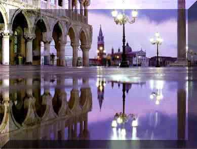
10 Main points to consider Which solution out of the proposed ones is better and why? Are there other options to place the sewage outlet? What will be the costs for the pipeline? How will the touristic industry be impacted? What about the water quality in the harbour? 19 Case 3: The Venice lagoon mobile barriers (MOSE) 50 km long 10 km wide 300,000 inhabitants 30,000,000 tourists annually 1.5 m average depth tidal range 1.0 m 50 km 2 salt marshes 10
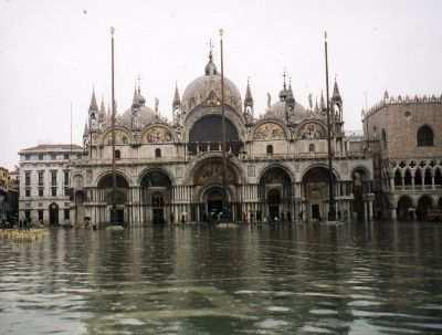
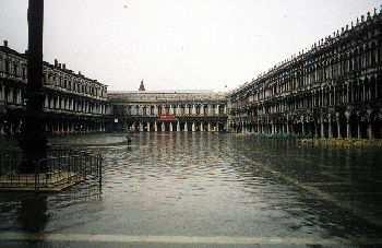
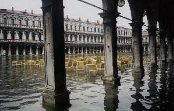
11 Hydrodynamic model: grid and bathymetry Venice is flooded 20 times a year 11

 Interventions at")
12 Annual frequency of flooding events (= tides >1.10 m above local datum) in Venice (from1872 to 2009) Interventions at the inlets: The Mose project 12


13 Mose: how it works Pros & Cons Very efficient for protection Work only if needed Do not change the water budget of the lagoon Can be used to artificially enhance circulation in the lagoon Localized interventions Very expensive Maintenance and management will be difficult Sea level rise will question the utility of the barriers Strong intervention in the natural equilibrium of the lagoon 13


14 The lagoon with tidal marshes Ship traffic and the MOSE The planned mobile barriers will not only change the water exchange with the open sea but they will also interfere with the ship traffic 14
 approx.")
15 IPCC report 2013 (AR5) Closures of Mose (projection) approx. 1 closure per day for 50 cm SLR 15
16 If or when? The question will not be ifit happens but whenit happens In this case the only possibility will be to cut off the lagoon from the Adriatic Sea, transforming it into a fresh water lake In order to close the lagoon some conditions must be fulfilled: no pollution a sewage system for the city of Venice the industrial and touristic port should be transferred out of the lagoon The Danube Delta or the Baltic lagoons show us nice examples of fresh water lagoons Main points to consider Can we estimate the benefits of limiting the water level to 110 cm? What is the implication to ship traffic? How many closures a year are affordable for the ship traffic and the water exchange? How will tourism be impacted by the MOSE? How can we deal with a regime shift in the ecological system? Do we maybe need an ecological model to deal with this? 32 16


17 Case 4: Connectivity in the Mar Menor The Mar Menoris a lagoon on the Mediterranean coast of Spain Touristic industry is very important The exchange with the Mediterranean is extremely limited 33 The Mar Menor is heavily populated 34 17


18 Modeling connectivity in the Mar Menor Connectivity results Range thickness

19 Connectivity results Edges filtered Range thickness Connectivity results Range of particles exchanged averaged on groups edges Range thickness
20 Connectivity results: conclusions Particles generated in the northern sub-basin are the most scattered in the lagoon; particles generated in the southern sub-basin are more confined. The central stations 31 and 23 act as transit areas. These patterns are consistent with the circulation of the main current at the Estacio inlet, which crosses the basin transversally. Enlarging the main entrance There is intention to enlarge the main entrance to the Mar Menor 40 20


21 The main entrance to the lagoon 41 The Mar Menor during Climate Change 42 21
22 Main points to consider What are the economic implications enlarging the inlet? How does the circulation change? Is it always beneficial having more exchange with the sea? What happens to salinity in the Mar Menor? Will the fish population change in the lagoon? How might tourism be affected by the opening? 43 22
Case Studies. Georg Umgiesser and Natalja Čerkasova KU, Lithuania
 Case Studies Georg Umgiesser and Natalja Čerkasova KU, Lithuania Case 1: A beach in the Curonian Lagoon Beach Current situation in Curonian lagoon Beach in Kintai In the past, especially in Baltic inner
COUPLED MANAGEMENT STRATEGY LAKE CATHIE ESTUARY & COAST
 Lake Cathie Progress Association Inc. ABN 28 251 433 854 P.O. Box 247 Lake Cathie NSW 2445 PHONE/FAX: 02 6584 8211 EMAIL: r3packag@bigpond.com 20 th October 2009 Port Macquarie Hastings Council PO Box
APPENDIX C. Fluvial and Tidal Hydraulics Report
 APPENDIX C Fluvial and Tidal Hydraulics Report BUENA VISTA LAGOON ENHANCEMENT PROJECT FLUVIAL AND TIDAL HYDRAULICS ANALYSES Prepared for: SANDAG 401 B Street, Suite 800 San Diego, California 92101 Contact:
Coastal Environments Oceanographic and Engineering Expertise
 Coastal Environments Oceanographic and Engineering Expertise Coastal Environments La Jolla, CA www.coastalenvironments.com 14 May 2004 CE Ref. No. 04-05 EcoSystems Management Associates, Inc. Carlsbad,
Presented by. Mr.Danish.D.R. M.Tech Coastal Management Institute for Ocean Management Anna University, Chennai Tamil Nadu, India.
 MATHEMATICAL MODEL STUDY OF THE EFFLUENT DISPOSAL FROM A DESALINATION PLANT IN THE MARINE ENVIRONMENT AT TUTICORIN Presented by Mr.Danish.D.R M.Tech Coastal Management Institute for Ocean Management Anna
Louisiana s 2012 Coastal Master Plan BARRIER SHORELINE MORPHOLOGY MODEL
 Louisiana Coastal Protection & Restorat coastal.louisiana.gov Louisiana s 2012 Coastal Master Plan PREDICTIVE MODELING: committed to our coast BARRIER SHORELINE MORPHOLOGY MODEL Dallon Weathers, University
Pathogen Transport in Coastal Environments: Case Studies of Urban Runoff in Southern California
 Pathogen Transport in Coastal Environments: Case Studies of Urban Runoff in Southern California A presentation to the Center for Water Sciences MSU Pathogens Workshop, April 20, 2007 Stanley B. Grant Henry
NYS Coastal Waters. Water Resources of NYS: THE NATURE of the COASTAL ZONE. NYS Coastal Waters. NYS Coastal Atlas. Coastal Zone Management 10/10/2014
 Water Resources of NYS: THE NATURE of the COASTAL ZONE NYS Coastal Waters NYS is the only state to border the Atlantic Ocean and the Great Lakes (Lakes Erie and Ontario). Great Lakes shoreline: 577 miles
INTRODUCTION TO COASTAL ENGINEERING
 The University of the West Indies Organization of American States PROFESSIONAL DEVELOPMENT PROGRAMME: COASTAL INFRASTRUCTURE DESIGN, CONSTRUCTION AND MAINTENANCE A COURSE IN COASTAL DEFENSE SYSTEMS I CHAPTER
Impacts of breakwaters and training walls
 Across the eastern seaboard of Australia, breakwaters and training walls have instigated fundamental perturbations to coastal and estuary processes. This has induced long-term changes to foreshore alignments,
Duckies have been found in Hawaii, Alaska, S. America, Scotland, Washington state and Australia as of 2012.
 Duckies have been found in Hawaii, Alaska, S. America, Scotland, Washington state and Australia as of 2012. We learned that it takes 3 years to complete one circuit of the North Pacific Gyre flow in the
Types of Estuaries and Mixing Patterns. Mrs. Stahl Marine Science Honors
 Types of Estuaries and Mixing Patterns Mrs. Stahl Marine Science Honors Coastal Plain Form between glacial periods, when water from melting glaciers raises the sea level and floods coastal plains and low
Hydrologic Feasibility of Storm Surge Barriers
 Hydrologic Feasibility of Storm Surge Barriers Malcolm J. Bowman, School of Marine and Atmospheric Sciences State University of New York, Stony Brook, NY. Presented at Against the Deluge: Storm Surge Barriers
Tanya M. Beck. Kelly Legault. Research Physical Scientist Coastal & Hydraulics Lab, ERDC Vicksburg, MS
 Inlet And Adjacent Shoreline Processes at Cascading Time Scales Using the Coastal Modeling System and GenCade Tanya M. Beck Research Physical Scientist Coastal & Hydraulics Lab, ERDC Vicksburg, MS Kelly
Ocean Motion Notes. Chapter 13 & 14
 Ocean Motion Notes Chapter 13 & 14 What is a Wave? Wave: movement of energy through a body of water How are Waves Caused? Caused mostly by wind Wind blowing on the water transmits energy to the water Size
Hydrodynamic and hydrological modelling to support the operation and design of sea ports
 Hydrodynamic and hydrological modelling to support the operation and design of sea ports Data needs and examples Martijn de Jong (port/nautical requirements, waves, currents) Sofia Caires (mean and extreme
EXISTING AND PLANNED STRATEGIES AND ACTIONS CONNECTED WITH COASTAL PROTECTION IN ASPECT OF PREDICTED SEA LEVEL RISE
 EXISTING AND PLANNED STRATEGIES AND ACTIONS CONNECTED WITH COASTAL PROTECTION IN ASPECT OF PREDICTED SEA LEVEL RISE Andrzej Cieślak Long term coastal protection strategy In 2000 a new 1 Polish long term
Implications of proposed Whanganui Port and lower Whanganui River dredging
 PO Box 637 Wanganui 4540 Attention: Rowan McGregor Dear Rowan 1 Summary We understand that it has been proposed to bring large vessels into the Port at Whanganui requiring the excavation of a channel up
Computational Analysis of Oil Spill in Shallow Water due to Wave and Tidal Motion Madhu Agrawal Durai Dakshinamoorthy
 Computational Analysis of Oil Spill in Shallow Water due to Wave and Tidal Motion Madhu Agrawal Durai Dakshinamoorthy 1 OUTLINE Overview of Oil Spill & its Impact Technical Challenges for Modeling Review
Bathing Water Profile - Carne (2017)
") Bathing Water Profile - Carne (2017) Bathing Water: Bathing Water Code: Local Authority: River Basin District: Monitoring Point: Carne IESEBWC050_0000_0300 Wexford County Council South Eastern 312952E,
Bathing Water Profile - Carne (2017) Bathing Water: Bathing Water Code: Local Authority: River Basin District: Monitoring Point: Carne IESEBWC050_0000_0300 Wexford County Council South Eastern 312952E,
IMPACTS OF COASTAL PROTECTION STRATEGIES ON THE COASTS OF CRETE: NUMERICAL EXPERIMENTS
 IMPACTS OF COASTAL PROTECTION STRATEGIES ON THE COASTS OF CRETE: NUMERICAL EXPERIMENTS Tsanis, I.K., Saied, U.M., Valavanis V. Department of Environmental Engineering, Technical University of Crete, Chania,
LAKKOPETRA (GREECE) EUROSION Case Study. Contact: Kyriakos SPYROPOULOS. TRITON Consulting Engineers. 90 Pratinou Str Athens (GREECE)
 EUROSION Case Study. Contact: Kyriakos SPYROPOULOS. TRITON Consulting Engineers. 90 Pratinou Str Athens (GREECE)") LAKKOPETRA (GREECE) Contact: Kyriakos SPYROPOULOS TRITON Consulting Engineers 90 Pratinou Str. 11634 Athens (GREECE) Tel: +32 10 729 57 61 Fax: +32 10 724 33 58 e-mail: kspyropoulos@tritonsa.gr 19 1 1.
LAKKOPETRA (GREECE) Contact: Kyriakos SPYROPOULOS TRITON Consulting Engineers 90 Pratinou Str. 11634 Athens (GREECE) Tel: +32 10 729 57 61 Fax: +32 10 724 33 58 e-mail: kspyropoulos@tritonsa.gr 19 1 1.
Currents measurements in the coast of Montevideo, Uruguay
 Currents measurements in the coast of Montevideo, Uruguay M. Fossati, D. Bellón, E. Lorenzo & I. Piedra-Cueva Fluid Mechanics and Environmental Engineering Institute (IMFIA), School of Engineering, Research
Eilat 's artificial lagoons project on the Red Sea - Israel R. Raviv Ir. R. Raviv, Coastal Engineering Ltd., P.O. Box 7322, z/b 37072,
 Eilat 's artificial lagoons project on the Red Sea - Israel R. Raviv Ir. R. Raviv, Coastal Engineering Ltd., P.O. Box 7322, z/b 37072, Introduction Eilat city is located in the southern part of the state
Modelling study of the dispersal of pollutants at SHo Jacinto submarine outfall (Aveiro, Portugal)
") Modelling study of the dispersal of pollutants at SHo Jacinto submarine outfall (Aveiro, Portugal) M. Ramosl, M. Almeidal, P. Silval, J. Dubertl & J. Antunes do Carrno2 l Department of Physics, University
Modelling study of the dispersal of pollutants at SHo Jacinto submarine outfall (Aveiro, Portugal) M. Ramosl, M. Almeidal, P. Silval, J. Dubertl & J. Antunes do Carrno2 l Department of Physics, University
MESSOLOGI LAGOON AREA (GREECE)
") MESSOLOGI LAGOON AREA (GREECE) 20 Contact: Kyriakos SPYROPOULOS TRITON Consulting Engineers 90 Pratinou Str. 11634 Athens (GREECE) Tel: +32 10 729 57 61 Fax: +32 10 724 33 58 e-mail: kspyropoulos@tritonsa.gr
MESSOLOGI LAGOON AREA (GREECE) 20 Contact: Kyriakos SPYROPOULOS TRITON Consulting Engineers 90 Pratinou Str. 11634 Athens (GREECE) Tel: +32 10 729 57 61 Fax: +32 10 724 33 58 e-mail: kspyropoulos@tritonsa.gr
Sea-Level Rise and Coastal Habitats in Southeastern Louisiana An Application of the SLAMM Model
 Sea-Level Rise and Coastal Habitats in Southeastern Louisiana An Application of the SLAMM Model Patty Glick (National Wildlife Federation) Jonathan Clough (Warren Pinnacle Consulting, Inc.) Amy Polaczyk
Tidal regime along Vietnam coast under impacts of sea level rise
 VNU Journal of Science, Earth Sciences 28 (2012) 133-139 Tidal regime along Vietnam coast under impacts of sea level rise Tran Thuc, Duong Hong Son* Vietnam Institute of Meteorology, Hydrology and Environment
Ocean Layers. Based on sunlight penetration: Based on water density: Sunlight (photosynthesis is possible) Twilight Midnight
 Twilight Midnight") PART 3 Ocean Layers Based on sunlight penetration: Sunlight (photosynthesis is possible) Twilight Midnight Based on water density: Mixed layer Pycnocline (rapid change of themperature/salinity) Deep ocean
PART 3 Ocean Layers Based on sunlight penetration: Sunlight (photosynthesis is possible) Twilight Midnight Based on water density: Mixed layer Pycnocline (rapid change of themperature/salinity) Deep ocean
Warm-up # 7 A day 5/17 - B day 5/18 UPDATE YOUR TABLE OF CONTENTS
 Warm-up # 7 A day 5/17 - B day 5/18 UPDATE YOUR TABLE OF CONTENTS Question: List all examples of surface water on Earth. Answer: Rivers and streams, lakes and reservoirs, (ponds) wetlands, estuaries and
GEOGRAPHY - STD 8 [ ] Q1.
![GEOGRAPHY - STD 8 [ ] Q1.](/thumbs/84/90631870.jpg "GEOGRAPHY - STD 8 [ ] Q1.") GEOGRAPHY - STD 8 Movements of Oceans [2016-2017] Q1. Name the two types of regular movements in the oceans. Ans. The regular movements in the ocean are of two types: 1. Horizontal Ocean currents 2. Vertical
GEOGRAPHY - STD 8 Movements of Oceans [2016-2017] Q1. Name the two types of regular movements in the oceans. Ans. The regular movements in the ocean are of two types: 1. Horizontal Ocean currents 2. Vertical
INTRODUCTION TO COASTAL ENGINEERING AND MANAGEMENT
 Advanced Series on Ocean Engineering Volume 16 INTRODUCTION TO COASTAL ENGINEERING AND MANAGEMENT J. William Kamphuis Queen's University, Canada World Scientific Singapore New Jersey London Hong Kong Contents
Montessori for Everyone 2013 Types of Coastlines
 Coast The coast is the part of the land that borders the sea. It is subject to constant change, as the result of the waves and deposits carried by water onto the land. Coastline The coastline is where
5/8/2018. Estuaries are classified by: > Mode of formation e.g. glaciers, deposition, sea level rise. > Patterns of water circulation
 Prepared by Diana Wheat-LBCC Compare and contrast the various types of estuaries, including their origin, size, shape, and general location on earth. Distinguish and describe the different types of habitats
Impact of Dredging the Lower Narrow River on Circulation and Flushing
 Impact of Dredging the Lower Narrow River on Circulation and Flushing Craig Swanson Ph.D. Swanson Environmental Alex Shaw Ocean Engineering, URI Prof. Malcolm L. Spaulding Ocean Engineering, URI 29 January
LITTLE LAGOON & LITTLE LAGOON PASS: RESEARCH UPDATES & DIRECTIONS
 LITTLE LAGOON & LITTLE LAGOON PASS: RESEARCH UPDATES & DIRECTIONS Bret M. Webb, PhD, PE, DCE Professor Department of Civil, Coastal, and Environmental Engineering October 19, 2017 LLPS Meeting Acknowledgments
Nature Of Marine winds, Waves and Swells over West African Coasts Case study of Victoria Island beach in Lagos, Nigeria
 Nature Of Marine winds, Waves and Swells over West African Coasts Case study of Victoria Island beach in Lagos, Nigeria By S. O. Gbuyiro and E. Olaniyan Marine Unit, Nigeria Meteorological Agency, Lagos
APPENDIX D W-19 FLUVIAL AND TIDAL HYDRAULIC, SEDIMENTATION, WATER QUALITY AND SEA LEVEL RISE MODELING STUDIES
 APPENDIX D W-19 FLUVIAL AND TIDAL HYDRAULIC, SEDIMENTATION, WATER QUALITY AND SEA LEVEL RISE MODELING STUDIES Final EIR November 2018 Appendices Executive Summary Background: The San Dieguito Lagoon W19
Tidally influenced environments. By Alex Tkaczyk, Henrique Menezes, and Isaac Foli
 Tidally influenced environments By Alex Tkaczyk, Henrique Menezes, and Isaac Foli Goals and aims Describe the role of tidal influence in depositional environments. - Deltas - Estuaries Provide an overview
MONITORING SEDIMENT TRANSPORT PROCESSES AT MANAVGAT RIVER MOUTH, ANTALYA TURKEY
 COPEDEC VI, 2003 in Colombo, Sri Lanka MONITORING SEDIMENT TRANSPORT PROCESSES AT MANAVGAT RIVER MOUTH, ANTALYA TURKEY Isikhan GULER 1, Aysen ERGIN 2, Ahmet Cevdet YALCINER 3 ABSTRACT Manavgat River, where
Chapter 6: Santander case
 6 Santander case 6.1 Introduction Port activity in Santander dates back more than 2,000 years ago. Throughout this period, the sea and the port have been the fundamental elements of a community which,
Regulation PM-10.0: Ships Ballast Water Management
 10.1. General Requirements 10.2 Ships Precaution for Loading Ballast 10.3 Ballast Water Management Plan 10.4 Reporting of Ballast water Reporting Form 10.5 EHS Role for Ballast Uptake 10.6 Ships Responsibility
Dr. Prakash N. Mesta
 Coastal Wetland Monitoring Dr. Prakash N. Mesta prakashhonavar@gmail.com Coastal Ecosystem is diverse in nature Most of the world human population p settled in Coastal region. Cities & Industries established
CALCASIEU SALINITY STRUCTURES. HYDRODYNAMIC MODELING (To Support Design of Salinity Barriers)
") CALCASIEU SALINITY STRUCTURES HYDRODYNAMIC MODELING (To Support Design of Salinity Barriers) Presentation Overview 1 2 3 4 5 Project Overview and CEA Circulation Modeling Vessel Hydrodynamics Modeling
CALCASIEU SALINITY STRUCTURES HYDRODYNAMIC MODELING (To Support Design of Salinity Barriers) Presentation Overview 1 2 3 4 5 Project Overview and CEA Circulation Modeling Vessel Hydrodynamics Modeling
Coastal Sediment Transport Modeling Ocean Beach & San Francisco Bight, CA
 1 Coastal Sediment Transport Modeling Ocean Beach & San Francisco Bight, CA Honghai Li and Lihwa Lin Engineering Research and Development Center U.S. Army Corps of Engineers Frank Wu, Lisa Andes, and James
Inlet Management Study for Pass-A-Grille and Bunces Pass, Pinellas County, Florida
 Inlet Management Study for Pass-A-Grille and Bunces Pass, Pinellas County, Florida Final Report Submitted By Ping Wang, Ph.D., Jun Cheng Ph.D., Zachary Westfall, and Mathieu Vallee Coastal Research Laboratory
The ocean water is dynamic. Its physical
 CHAPTER MOVEMENTS OF OCEAN WATER The ocean water is dynamic. Its physical characteristics like temperature, salinity, density and the external forces like of the sun, moon and the winds influence the movement
Real Time Surveying GPS and HYDRO Software for Tide and Swell Compensation
 Real Time Surveying GPS and HYDRO Software for Tide and Swell Compensation by Mr Michael Walker, B.Surv. (Otago) HYDRO Division Trimble Navigation New Zealand Ltd. Abstract This paper focuses on the use
SURGE SUPPRESSION ACHIEVED BY DIFFERENT COASTAL SPINE (IKE DIKE) ALIGNMENTS. Bruce A. Ebersole, Thomas W. Richardson and Robert W.
 ALIGNMENTS. Bruce A. Ebersole, Thomas W. Richardson and Robert W.") SURGE SUPPRESSION ACHIEVED BY DIFFERENT COASTAL SPINE (IKE DIKE) ALIGNMENTS Abstract Bruce A. Ebersole, Thomas W. Richardson and Robert W. Whalin, Jackson State University, Jackson, Mississippi The primary
SURGE SUPPRESSION ACHIEVED BY DIFFERENT COASTAL SPINE (IKE DIKE) ALIGNMENTS Abstract Bruce A. Ebersole, Thomas W. Richardson and Robert W. Whalin, Jackson State University, Jackson, Mississippi The primary
Chapter 11 Tides. A tidal bore is formed when a tide arrives to an enclosed river mouth. This is a forced wave that breaks.
 Chapter 11 Tides A tidal bore is formed when a tide arrives to an enclosed river mouth. This is a forced wave that breaks. Tidal range can be very large Tide - rhythmic oscillation of the ocean surface
Habitat Fact Sheets. Rocky habitats are dominated by seaweeds and often mussels, which rely on the rocks for attachment.
 Habitat Fact Sheets Habitats in the Gulf of Maine serve many important roles for the environment and for humans as well. These include: cycling nutrients, filtering pollution, trapping sediments, storing
Nearshore Dredged Material Placement Pilot Study at Noyo Harbor, CA
 1 Nearshore Dredged Material Placement Pilot Study at Noyo Harbor, CA Noyo Cove N 2011 National Conference on Beach Preservation Technology 9-11, February 2011 Lihwa Lin, Honghai Li, Mitchell Brown US
RESOLUTION MEPC.136(53) Adopted on 22 July 2005 DESIGNATION OF THE BALTIC SEA AREA AS A PARTICULARLY SENSITIVE SEA AREA
 Adopted on 22 July 2005 DESIGNATION OF THE BALTIC SEA AREA AS A PARTICULARLY SENSITIVE SEA AREA") MEPC 53/24/Add.2 RESOLUTION MEPC.136(53) THE MARINE ENVIRONMENT PROTECTION COMMITTEE, BEING AWARE of the ecological, social, economic, cultural, scientific and educational value of the Baltic Sea Area,
MEPC 53/24/Add.2 RESOLUTION MEPC.136(53) THE MARINE ENVIRONMENT PROTECTION COMMITTEE, BEING AWARE of the ecological, social, economic, cultural, scientific and educational value of the Baltic Sea Area,
APPENDIX A Hydrodynamic Model Qualicum Beach Waterfront Master Plan
 Page 1 of 21 CLIENT: Town of Qualicum Beach PROJECT: SIGNATURE DATE CONTRIBUTORS : M. Marti Lopez REVIEWED BY : P. St-Germain, EIT APPROVED BY: J. Readshaw, P.Eng ISSUE/REVISION INDEX Issue Details Code
MAY0 COUNTY COUNCIL W.ESTPORT MARINE SURVEY
 MAY0 COUNTY COUNCIL W.ESTPORT MARINE SURVEY VOLUME 1 HYDRODYNAMIC & WATER QUALITY MODELLINQ Tolaphano 0232 667914 Fwlmlk a=z 668288 Morton PREFACE,*.--. -- - -I Kirk McClure Morton, in conjunction with
105 CMR MINIMUM STANDARDS FOR BATHING BEACHES STATE SANITARY CODE, CHAPTER VII
 105 CMR 445.000 MINIMUM STANDARDS FOR BATHING BEACHES STATE SANITARY CODE, CHAPTER VII 445.001: Purpose The purpose of 105 CMR 445.000 is to protect the health, safety and well-being of the users of bathing
Variability of surface transport in the Northern Adriatic Sea from Finite-Size Lyapunov Exponents" Maristella Berta
 Variability of surface transport in the Northern Adriatic Sea from Finite-Size Lyapunov Exponents" Maristella Berta Marseille, 29 November 2011 Outline Geographical setting (winds and circulation of Adriatic
Directed Reading. Section: Ocean Currents. a(n). FACTORS THAT AFFECT SURFACE CURRENTS
. FACTORS THAT AFFECT SURFACE CURRENTS") Skills Worksheet Directed Reading Section: Ocean Currents 1. A horizontal movement of water in a well-defined pattern is called a(n). 2. What are two ways that oceanographers identify ocean currents? 3.
Skills Worksheet Directed Reading Section: Ocean Currents 1. A horizontal movement of water in a well-defined pattern is called a(n). 2. What are two ways that oceanographers identify ocean currents? 3.
Feasibility Study for Restoration of Titlow Lagoon Fish Passage. South Puget Sound Salmon Enhancement Group
 Feasibility Study for Restoration of Titlow Lagoon Fish Passage South Puget Sound Salmon Enhancement Group January 2010 Feasibility Study for Restoration of Titlow Lagoon Fish Passage Prepared for South
Leaning Into Adaptation
 www.marinslr.org Leaning Into Adaptation GFNMS Ocean Summit, May 17, 2016 Jack Liebster, Planning Manager, Marin County Marin County C-SMART Sea Level Rise Adaptation Process Evaluate Science Info. Implement
Texas Water Resources Institute
 Texas Water Resources Institute November/December 1982 Volume 8 No. 6 A Precise Environment By Lou Ellen Ruesink, Editor, Texas Water Resources Aquarium enthusiasts know just how particular fish are about
Figure 1. Schematic illustration of the major environments on Mustang Island.
 STOP #1: PACKERY CHANNEL BEACH TO BAY We will start this field guide near the north jetty of Packery Channel and hike across the island to Corpus Christi Bay (fig. 1). The island emerges from the Gulf
BEACH NOURISHMENT BY RAINBOWING FOR THE VISAKHAPATNAM PORT TRUST BY DCI. Capt. MVR MURTHY ABSTRACT
 BEACH NOURISHMENT BY RAINBOWING FOR THE VISAKHAPATNAM PORT TRUST BY DCI Capt. MVR MURTHY ABSTRACT The coastal city of Visakhapatnam had a long wide beach. Over past three decades, this beach has progressively
7.4 Temperature, Salinity and Currents in Jamaica Bay
 7.4 Temperature, Salinity and Currents in Jamaica Bay Arnold Gordon, Bruce Huber and Robert Houghton 7.4.1 INTRODUCTION Jamaica Bay stratification is weakly indicative of a shallow, tidally active environment,
Training program on Modelling: A Case study Hydro-dynamic Model of Zanzibar channel
 Training program on Modelling: A Case study Hydro-dynamic Model of Zanzibar channel Mayorga-Adame,C.G., Sanga,I.P.L., Majuto, C., Makame, M.A., Garu,M. INTRODUCTION Hydrodynamic Modeling In understanding
Montserrat. Wise practices for coping with. i b bea n Se a
 Wise practices for coping with Montserrat Car i b bea n Se a Fisheries Division, Montserrat Physical Planning Department, Montserrat University of Puerto Rico, Sea Grant College Program Caribbean Development
LOCAL COASTAL PROGRAM UPDATE
 LOCAL COASTAL PROGRAM UPDATE Agenda Meeting #1 General Information (1 1:45 pm) Introductions and Background Grants involved What is a Local Coastal Program? What is required? LCP Update tasks and schedule
Chapter 10 Lecture Outline. The Restless Oceans
 Chapter 10 Lecture Outline The Restless Oceans Focus Question 10.1 How does the Coriolis effect influence ocean currents? The Ocean s Surface Circulation Ocean currents Masses of water that flow from one
14 EFFECTS ON HARBOUR WAVES & CURRENTS
 14 EFFECTS ON HARBOUR WAVES & CURRENTS Effects of Channel Deepening Project on Waves and Tidal Currents in Lyttelton Harbour/Whakaraupō Derek G. Goring Prepared for: Lyttelton Port Company Ltd Client Report
A STUDY OF THE PHYSICAL ENVIRONMENT AND WATER CIRCULATION IN FARWA LAGOON, LIBYA
 131 A STUDY OF THE PHYSICAL ENVIRONMENT AND WATER CIRCULATION IN FARWA LAGOON, LIBYA 1 2 M. GERGES and A. DURGHAM 1 UNESCO E:x:pex>t at MRC 2Marine Scientist at MB.C, TX'ipoU, Libya, S.P.L.A.J. ABSTRACT
A Threatened Bay: Challenges to the Future of the Penobscot Bay Region and its Communities
 A Threatened Bay: Challenges to the Future of the Penobscot Bay Region and its Communities 1 A A Threatened Bay: Challenges to the Future of the Penobscot Bay Region and its Communities In 1996 the Island
Shoreline Change in Response to Sea Level Rise on Florida s Panhandle Coast. Jim Houston `
 Shoreline Change in Response to Sea Level Rise on Florida s Panhandle Coast Jim Houston james.r.houston @usace.army.mil ` Approach Calculate historical shoreline change by county (1867-2015) Determine
Lecture Outlines PowerPoint. Chapter 15 Earth Science, 12e Tarbuck/Lutgens
 Lecture Outlines PowerPoint Chapter 15 Earth Science, 12e Tarbuck/Lutgens 2009 Pearson Prentice Hall This work is protected by United States copyright laws and is provided solely for the use of instructors
On the role of Posidonia oceanica on Mediterranean beaches
 Water Wave Mechanics and Coastal Engineering Imposición Medalla como Académico Correspondiente de la RAI al Prof. R.A. Dalrymple On the role of Posidonia oceanica on Mediterranean beaches Lluís GÓMEZ-PUJOL
Mechanisms and Characteristics of High-Speed Reef Rip Current
 Mechanisms and Characteristics of High-Speed Reef Rip Current Ryuichiro Nishi, Mario P. de Leon, Kouji Horinouchi,Akira Ohtani, Nicholas C. Kraus, and Julianti K. Manu Many people utilize beaches, but
FINAL REPORT APPENDIX A. Physical Description of the Shubenacadie River
 FINAL REPORT APPENDIX A Physical Description of the Shubenacadie River Smart Solutions for Engineering, Science and Computing Physical Description of the Shubenacadie River Martec Technical Report # TR-07-12
Follets Island Nearshore Beach Nourishment Project
 Coast & Harbor Engineering A division of Hatch Mott MacDonald Follets Island Nearshore Beach Nourishment Project Arpit Agarwal, P.E. April 1, 2016 Project Site!"#$% &'(% &)*+% )#,'-+% Shoreline Erosion
3.3 OCEANOGRAPHY/COASTAL PROCESSES
 3.3 OCEANOGRAPHY/COASTAL PROCESSES Beaches are dynamic and conditions vary based on the onshore/offshore movement of sand both seasonally and annually. Sand also moves alongshore within a generally defined
Assessing the spatial dynamics of Small Scale Coastal Fisheries of the Baltic Sea. A Geographic Information System based approach
 Assessing the spatial dynamics of Small Scale Coastal Fisheries of the Baltic Sea A Geographic Information System based approach Eva Papaioannou 1, Athanasios Vafeidis 1, Jörn Schmidt 2, Martin Quaas 2
SUMP of Ravenna: relevant experiences on travel behavior change
 SUMP of Ravenna: relevant experiences on travel behavior change Nicola Scanferla, Head of Mobility Planning Unit Giorgia Rambaldi, Mobility Planning Unit nscanferla@comune.ra.it giorgiarambaldi@comune.ravenna.it
Redondo Beach Boat Launch Ramp Facility
 Redondo Beach Boat Launch Ramp Facility Feasibility Report for the California Department of Boating and Waterways 2015 Grant Cycle For the City of Redondo Beach Submitted by March 13, 2014 Table of Contents
NNBF Examples and Flood Risk Reduction Measures in the Netherlands
 NNBF Examples and Flood Risk Reduction Measures in the Netherlands Quirijn Lodder Principal Advisor Coastal Flood Risk Management TU Delft NASA I like to read history books.. 2 I like to read history books..
Tides. Tides: longest waves. or seas. or ripples
 Tides or ripples or seas Tides: longest waves Tides Definition: The rise and fall of sea level due to the gravitational forces of the Moon and Sun and the rotation of the Earth. Why tides are important?
Bathing Water Directive report Austria
 Bathing Water Directive report 2013 Austria The report gives a general overview of information acquired from the reported data, based on provisions of the Bathing Water Directive 1. The reporting process
PEDESTRIAN ACTION PLAN
 ATTACHMENT 2 CITY OF SANTA MONICA PEDESTRIAN ACTION PLAN CITY OF SANTA MONICA PEDESTRIAN ACTION PLAN This page intentionally left blank EXECUTIVE SUMMARY CHAPTER 1 EXECUTIVE SUMMARY Setting the Stage
St. Johns River Water Supply Impact Study (WSIS)
") St. Johns River Water Supply Impact Study (WSIS) Michael G. Cullum, P.E. Chief, Bureau of Engineering & Hydro Science St. Johns River Water Management District The Water Supply Impact study is the most
St. Johns River Water Supply Impact Study (WSIS) Michael G. Cullum, P.E. Chief, Bureau of Engineering & Hydro Science St. Johns River Water Management District The Water Supply Impact study is the most
Climate Change and Security:
 Climate Change and Security: Ideas & Inspiration from Annapolis Angela Schedel, CDR, U.S. Navy Assistant Professor, U.S. Naval Academy Presented on September 13, 2016 at USFSP icar Workshop Disclaimer
Assessment of flooding on low-elevation reef-lined coasts
 Assessment of flooding on low-elevation reef-lined coasts Ap van Dongeren, Deltares, Delft, The Netherlands With Curt Storlazzi, USGS, Santa Cruz, USA Impact on coral reef-lined islands and coasts Coral
TRAFFIC SEPARATION SCHEMES IN THE ADRIATIC SEA
 DRUŠTVO ZA POMORSKO PRAVO SLOVENIJE MARITIME LAW ASSOCIATION OF SLOVENIA EUROPEAN MARITIME DAY 2011 TRAFFIC SEPARATION SCHEMES IN THE ADRIATIC SEA Hrvoje Kačić Paper presented at the round-table EU Maritime
Land use changes and their impacts on extreme events. By Millán M. Millán
 Land use changes and their impacts on extreme events By Millán M. Millán Conference: Land as a Resource, Brussels 19 June 2014 Atlantic Fronts 20% Decreasing Summer Storms 15% Decreasing Gone Mediterranean
OIL SUPPLY SYSTEMS ABOVE 45kW OUTPUT 4.1 Oil Supply
 OIL SUPPLY SYSTEMS ABOVE 45kW OUTPUT 4.1 Oil Supply 4.1.1 General The primary function of a system for handling fuel oil is to transfer oil from the storage tank to the oil burner at specified conditions
WHITE PAPER: TRANSIT SERVICE FOR SOUTH SHAGANAPPI
 9/27/2012 TRANSIT PLANNING WHITE PAPER: TRANSIT SERVICE FOR SOUTH SHAGANAPPI 2012 Calgary Transit 1 Table of Contents Purpose... 3 Area of Change... 3 Background... 3 Access to destinations... 5 Connecting
PREDICTION OF FUTURE SHORELINE CHANGE WITH SEA-LEVEL RISE AND WAVE CLIMATE CHANGE AT HASAKI, JAPAN
 PREDICTION OF FUTURE SHORELINE CHANGE WITH SEA-LEVEL RISE AND WAVE CLIMATE CHANGE AT HASAKI, JAPAN Masayuki Banno 1 and Yoshiaki Kuriyama 1 We developed a shoreline change model considering the effects
General Guidance on the Voluntary Interim Application of the D1 Ballast Water Exchange Standard in the North-East Atlantic and the Baltic Sea
 General Guidance on the Voluntary Interim Application of the D1 Ballast Water Exchange Standard in the North-East Atlantic and the Baltic Sea All 21 countries in HELCOM and OSPAR have signed up to the
MAR 110 LECTURE #22 Standing Waves and Tides
 27 October 2007 MAR110_Lec22_standing Waves_tides_27oct07.doc 1 MAR 110 LECTURE #22 Standing Waves and Tides Coastal Zone Beach Profile Figure 22.1 Beach Profile Summer Onshore Sand Transport Breaking
March Maidstone Integrated Transport Strategy Boxley Parish Council Briefing Note. Context. Author: Parish Clerk 2 March 2016
 Context. Author: Parish Clerk 2 The Draft Integrated Transport Policy (DITS) sets out a vision and objectives, and identifies a detailed programme of interventions to support the Maidstone Borough Local
Monitoring tidal movements in Cook Inlet, Alaska, using the integration of remote sensing data, GIS, and inundation models
 Monitoring tidal movements in Cook Inlet, Alaska, using the integration of remote sensing data, GIS, and inundation models Hua Liu Department of political Science and Geography Old Dominion University
GENERAL METHODOLOGY FOR INLET RESERVOIR MODEL ANALYSIS OF SAND MANAGEMENT NEAR TIDAL INLETS. Mohamed A. Dabees 1, Nicholas C.
 GENERAL METHODOLOGY FOR INLET RESERVOIR MODEL ANALYSIS OF SAND MANAGEMENT NEAR TIDAL INLETS Mohamed A. Dabees 1, Nicholas C. Kraus 2 1 Humiston& Moore Engineers, 5679 Strand Court, Naples, FL 34109, USA.
VENICE LOCAL COASTAL PROGRAM UPDATE: COASTAL HAZARDS WELCOME
 VENICE LOCAL COASTAL PROGRAM UPDATE: COASTAL HAZARDS WELCOME 1 Introducing the Team Hosted by the Department of City Planning and grant funded in part by the California Coastal Commission 2 Workshop Purpose
Compiled by Uwe Dornbusch. Edited by Cherith Moses
 REPORT ON WAVE AND TIDE MEASUREMENTS Compiled by Uwe Dornbusch. Edited by Cherith Moses 1 Aims...1 2 Summary...1 3 Introduction...1 4 Site selection...1 5 Wave recorder settings...2 6 Results...2 6.1 Water