Geographic Response Plan Map: SFL-25. Map continued on: SFL-29. Lignumvitae Key. Aquatic Preserve. Lignumvitae Key Botanical.
|
|
|
- Simon Goodman
- 6 years ago
- Views:
Transcription
1 ! 25 0'0"N 80 45'0"W Spy Key Geographic Response Plan Map: SFL-25 Panhandle Key Panhandle Key Florida Bay Map continued on: SFL-29 Crab Keys West Key 80 37'30"W 25 0'0"N Crane Keys Crane Keys XXX j Everglades National Park S K [ j Everglades National Park [] [ Cotton Key SFL26-03 Cotton Key XXX W F SFL26-03 Ge Cotton Key Cotton Key SFL26-0 Theater the Sea 02 nan st) Bank Map continued on: SFL hanan Bank 24 52'30"N '0"W XXX SFL25-01 Peterson Key 5450 u Florida Keys National Marine Sanctuary SFL23-01 Lower Matecumbe Development [«!d Peterson Key Bank!d! Matecumbe Bight SFL25-02 Lignumvitae Key Lignumvitae Key Lign umvitae Channel SFL25-06 Lower Matecumbe Key (Bayside)!d Legend Environmentally Sensitive Areas Summer Protection Priority X 75![] Incident Command Post American - Protect First XXXA B - Protect after A Areas XX!S( [y Staging Areas Aquaculture 74! XXX C - Protect after B Areas X!R( k State Park/Aquatic Preserve Oil Spill Risk Sites Acropora Priority Sites!E( [m Priority of Protection High Recreation Beach!! Equipment Storage Locations A - Protect First F!! B - Protect after A Areas Response Methods [z Tidal Inlet Protection Strategy Black Bear Bio-Socioeconomic «Skimmer!( [\!d Boat Ramp h Beach Access Shallow Water Skimmer! "J! Cape Sable Seaside Sparrow # Airport [s Collection Point # Coast Guard Natural Collection Point!!!!!!!!!!!! General Booming Strategy (Length in Feet) 76 XXX!!!d!d!!d!^ Coral Crocodile Lower Matecumbe [b Everglades Key XXX k Lignumvitae Key Aquatic Preserve k Lignumvitae Key Botanical State Park SFL25-03 Shell Key k Indian Key SFL25-07 Historic San Pedro State Park Archaeological!S Site ( 78! 77!S (!d Reef Monitoring Site Snail Kite Florida Panther!Å Heliport! Manatee u Marine Sanctuary [v NERR [j National Park F XXX!d F!d SFL25-08 Indian Key Map continued on: SFL-23!h Naval [«Piping [ Rice! Sea [ Smalltooth!q Water [r Wildlife Facility Plover Rat Turtle Sawfish Intake Refuge 6850 XXX Shell Key 3800 F 2350 SFL25-04 Yellow Shark Channel Hampton Inn 80! Islamorada 79! XXX 1 XXX [\!d Village of Islamorada E.O.C. [\ XXX! 81 Upper Matecumbe Key Teatable Key Channel Indian Key Channel k Lignumvitae Key Botanical State Park Islamorada!d! 4550 u 82! 2750 SFL25-05 Upper Matecumbe Beach Atlantic Ocean µ Mangroves Sea Turtle Nesting Beach Federal Managed Areas State Managed Areas State Waters/County Line Fish and Wildlife USCG Sector Boundary Research Institute 1700! h ( 80 37'30"W Sector St. Petersburg Sector Key West Miles Florida Keys Area Committee Sector Miami Sector Key West Map continued on: SFL-26 83! Islamorada 4100 XXX!S( F!d C Sanc!^ C R SFL26-07 Cheeca Rocks 24 52'30"N SFL2 Alliga
2 80 41'15"W Geographic Response Plan Map: SFL-25SE Map continued on: SFL-26NW 80 37'30"W 24 56'15"N Florida Bay 24 56'15"N 83!!S(!d 24 52'30"N F 80 41'15"W Legend 78! k Indian Key Historic State Park XXX SFL25-07 San Pedro Archaeological Site Environmentally Sensitive Area Summer Protection Priority - XXXA B XX X C Protect First - Protect after A Areas - Protect after B Areas Acropora Priority Sites Priority of Protection!!!! A - Protect First!!!!!!!!!!!!! B - Protect after A Areas Response Methods «Skimmer!( h Shallow Water Skimmer Collection Point # Natural Collection Points # General Booming Strategy (Length in Ft) k Lignumvitae Key Botanical State Park F!S(!d Indian Key Channel Shell Key k Lignumvitae Key Aquatic Preserve 1 XXX Incident Command Posts!S( Staging Areas!R( Oil Spill Risk Sites!E( Equipment Storage Locations F Tidal Inlet Protection Strategy Bio-Socioeconomic [\ Beach Access! Airport [] American Crocodile!d SFL25-08 Indian Key 3800 SFL25-03 Shell Key SFL25-04 Yellow Shark Channel 79! XXX F Teatable Key Channel 2350 [y Aquaculture k State Park/Aquatic Preserve [m High Recreation Beach [z Black Bear!d Boat Ramp "J! Cape Sable Seaside Sparrow [s Coast Guard!^ Coral Reef Monitoring Site [b Everglades XXX Yellow Shark Channel [\ Snail Kite Florida Panther!Å Heliport! Manatee Marine Sanctuary u [v NERR [j National Park!h Naval Facility 80!!d Hampton Inn Islamorada [«Piping [ Rice! Sea [ Smalltooth!q Water [r Wildlife Plover Rat Turtle Sawfish Intake Refuge!d [\ 81! XXX SFL25-05 Upper Matecumbe Beach Upper Matecumbe Key k Village of Islamorada E.O.C.! 4550!d Islamorada 82! u Florida Keys National Marine Sanctuary Atlantic Ocean µ Mangroves Sea Turtle Nesting Beach Federal Managed Area State Managed Area Lignumvitae Key State Waters/County Boundary USCG Sector Botanical Boundary Fish and Wildlife State Research Park Institute Miles 2750! h ( '30"W Sector St. Petersburg Sector Key West Florida Keys Area Committee Sector Miami Sector Key West Map continued on: SFL-26SW XXX Islamo S SFL26-07 Cheeca Ro 24 52'30"N
3 GRP - Oil Spill Sensitive Site Report for Sector : Key West GRP Map # SFL-25 Name: Peterson Key Protection Priority (Season): Site Description: Spring: A Summer: A Fall: A Winter: A Site ID: Latitude (DMS): 24 54' " Longitude (DMS): 80 44' " County: Monroe Latitude (DD): Longitude (DD): SCAT Division: Monroe County Division 6 ESI Map: S.FL-25 ESI Name: UPPER MATECUMBE KEY, FLA. NOAA Chart 11449_1 CHART Name INTRACOASTAL WATERWAY MATECUMBE TO GRASSY KEY USGS Quad: H6 QUAD Name: Upper Matecumbe Key Managed Area (if applicable): Everglades National Park General Location: Contacts: Shoreline Type: GEOSPATIAL INFORMATION CONTACT INFORMATION SFL25-01 FL State Watch Office ; NOAA - FL Keys National Marine Sanctuary (Superintendent) ; FWC Non- Game Biologist ; National Response Center ; Everglades/Biscayne Dispatch or ENP ; Lignumvitae Key Botanical State Park (Manager) or ; NOAA - SSC (USCG District 7) ; DOI - Regional Environmental Officer or RESOURCES AT RISK INFORMATION Habitat: Wildlife: Mangrove Island, Shallow Seagrass Waterfowl, diving bird, wading bird colonies-great white herons, passerine birds, seagrass beds and benthic community Threaten/Endangered Species: Manatee, Smalltooth Sawfish, Sea Turtles (Green, Loggerhead, Hawksbill, Kemp's Ridley: nesting and nonnesting), Crocodiles, Bald Eagle Socio-Economic Resources: Staging Area Collection Points: Area Access: Spill Risk: Response Resources: RESPONSE CONSIDERATIONS Robbie's Marina, Indian Key Fill, Fiesta Key RV Resort Open water Collection/Recovery (skimming) boat/helicopter Snake Creek Marina, USCG Islamorada available PROTECTION STRATEGY INFORMATION Tidal Range (FT): Average Current (KTS): Ease of Protection: Min. Boom Length (FT): 3,000 Boom Type: Booming Method: Containment, Ensnarement Protection Strategy: Surround island/key with protective sorbent (1,500') and collection boom (1,500'). Use Ranger guidance during boom deployment. Minimum resources needed for on water recovery: 2 shallow water skimmers. 5,000' deflection boom, size and type to be determined by location of spill and weather conditions to include wind and sea state. Response strategy to be based on over flight observations and trajectory modeling if available. Availability of collection/deflection booms and weather/tidal conditions will affect tactics and resource protection strategies. Protection will be focused on choke points to prevent contamination of sensitive areas. Near shore, consider sorbent boom or snare boom deployed by shallow water vessels to protect sensitive shorelines. In-situ burning may be a consideration. Report produced by Florida FWC - Fish and Wildlife Research Institue on: Monday, July 02, 2012 For additional information, please contact FWC-FWRI Center for Spatial Analysis (727)
4 GRP - Oil Spill Sensitive Site Report for Sector : Key West GRP Map # SFL-25 Name: Site Description: Lignumvitae Key Protection Priority (Season): Spring: A Summer: A Fall: A Winter: A Site ID: Latitude (DMS): 24 54' 5.000" N Longitude (DMS): 80 41' " County: Monroe Latitude (DD): Longitude (DD): SCAT Division: Monroe County Division 6 ESI Map: S.FL-25 ESI Name: UPPER MATECUMBE KEY, FLA. NOAA Chart 11449_1 CHART Name INTRACOASTAL WATERWAY MATECUMBE TO GRASSY KEY USGS Quad: H6 QUAD Name: Upper Matecumbe Key General Location: GEOSPATIAL INFORMATION SFL25-02 Managed Area (if applicable): Florida Keys National Marine Sanctuary; Lignumvitae Key Botanical State Park; Lignumvitae Key Aquatic Preserve Contacts: Shoreline Type: CONTACT INFORMATION FL State Watch Office ; Everglades/Biscayne Dispatch or ENP ; FWC Non-Game Biologist ; National Response Center ; Lignumvitae Key Botanical State Park (Manager) or ; FWC Non-Game Biologist ; NOAA - SSC (USCG District 7) ; DOI - Regional Environmental Officer or RESOURCES AT RISK INFORMATION Habitat: Wildlife: Rocky shores, Mangroves, Shallow flats, Seagrass beds Wading birds, Fishes, Corals, invertebrates associated with shallows Threaten/Endangered Species: Several species of birds, Corals, Sea turtles, Sea mammals Socio-Economic Resources: Submerged and terrestrial cultural/historic resources Staging Area Collection Points: Area Access: Spill Risk: Response Resources: Indian Key Fill, Robbie's Marina Indian Key Fill boat/helicopter RESPONSE CONSIDERATIONS USCG Islamorada available, Vessel operations will be restricted to marked channels PROTECTION STRATEGY INFORMATION Tidal Range (FT): Average Current (KTS): Ease of Protection: Min. Boom Length (FT): 20,000 Boom Type: Booming Method: Protection/Exclusion Protection Strategy: 20,000-30,000' total diversion boom as shown on map SFL-23. Only method for protecting area. State historic site submerged at San Pedro. Don't anchor on wreck. Use Ranger guidance during boom deployment. No dispersants or insitu burning. Min. resources needed for on water recovery: 2 shallow water skimmers. 5,000' deflection boom, size and type to be determined by location of spill and weather conditions to include wind and sea state. Response strategy based on over flight observations and trajectory modeling if avail. Availability of collection/deflection boom & weather/tidal conditions will affect tactics and resource protection strategies. Protection will be focused on choke points to prevent contamination of sensitive areas. Near shore consider sorbent or snare boom deployed by shallow water vessels to protect sensitive shorelines. Report produced by Florida FWC - Fish and Wildlife Research Institue on: Monday, July 02, 2012 For additional information, please contact FWC-FWRI Center for Spatial Analysis (727)
5 GRP - Oil Spill Sensitive Site Report for Sector : Key West GRP Map # SFL-25 Name: Shell Key Protection Priority (Season): Site Description: Spring: A Summer: A Fall: A Winter: A Site ID: Latitude (DMS): 24 55' " Longitude (DMS): 80 39' " County: Monroe Latitude (DD): Longitude (DD): SCAT Division: Monroe County Division 6 ESI Map: S.FL-25 ESI Name: UPPER MATECUMBE KEY, FLA. NOAA Chart 11449_1 CHART Name INTRACOASTAL WATERWAY MATECUMBE TO GRASSY KEY USGS Quad: H6 QUAD Name: Upper Matecumbe Key General Location: GEOSPATIAL INFORMATION SFL25-03 Managed Area (if applicable): Florida Keys National Marine Sanctuary; Lignumvitae Key Botanical State Park; Lignumvitae Key Aquatic Preserve Contacts: Shoreline Type: CONTACT INFORMATION FL State Watch Office ; Everglades/Biscayne Dispatch or ENP ; FWC Non-Game Biologist ; National Response Center ; Lignumvitae Key Botanical State Park (Manager) or ; NOAA - FL Keys National Marine Sanctuary (Superintendent) ; NOAA - SSC (USCG District 7) ; DOI - Regional Environmental Officer , , (24hrs) or RESOURCES AT RISK INFORMATION Habitat: Wildlife: Mangroves, Shallow flats, Seagrass beds Wading birds, Fishes, Corals, invertebrates associated with shallows Threaten/Endangered Species: Several species of birds, Corals, Sea turtles, Sea mammals Socio-Economic Resources: Staging Area Collection Points: Area Access: Spill Risk: RESPONSE CONSIDERATIONS Indian Key Fill, Robbie's Marina, Whale Harbor Restaurant and Marina Indian Key Fill boat Response Resources: USCG Islamorada available, Vessel operations will be restricted to marked channels PROTECTION STRATEGY INFORMATION Tidal Range (FT): Average Current (KTS): Ease of Protection: Min. Boom Length (FT): 20,000 Boom Type: Booming Method: Deflection Protection Strategy: 20,000-30,000' total diversion boom as shown on map SFL-23. Only method for protecting area. State historic site submerged at San Pedro. Don't anchor on wreck. Use Ranger guidance during boom deployment. No dispersants or insitu burning. Min. resources needed for on water recovery: 2 shallow water skimmers. 5,000' deflection boom, size and type to be determined by location of spill and weather conditions to include wind and sea state. Response strategy based on over flight observations and trajectory modeling if avail. Availability of collection/deflection boom & weather/tidal conditions will affect tactics and resource protection strategies. Protection will be focused on choke points to prevent contamination of sensitive areas. Near shore consider sorbent or snare boom deployed by shallow water vessels to protect sensitive shorelines. Report produced by Florida FWC - Fish and Wildlife Research Institue on: Monday, July 02, 2012 For additional information, please contact FWC-FWRI Center for Spatial Analysis (727)
6 GRP - Oil Spill Sensitive Site Report for Sector : Key West GRP Map # SFL-25 Name: Site Description: Yellow Shark Channel Protection Priority (Season): Spring: A Summer: A Fall: A Winter: A Site ID: Latitude (DMS): 24 54' " Longitude (DMS): 80 39' " County: Monroe Latitude (DD): Longitude (DD): SCAT Division: Monroe County Division 6 ESI Map: S.FL-25 ESI Name: UPPER MATECUMBE KEY, FLA. NOAA Chart 11449_1 CHART Name INTRACOASTAL WATERWAY MATECUMBE TO GRASSY KEY USGS Quad: H6 QUAD Name: Upper Matecumbe Key General Location: GEOSPATIAL INFORMATION SFL25-04 Managed Area (if applicable): Florida Keys National Marine Sanctuary; Lignumvitae Key Botanical State Park; Lignumvitae Key Aquatic Preserve Contacts: Shoreline Type: CONTACT INFORMATION FL State Watch Office ; Everglades/Biscayne Dispatch or ENP ; FWC Non-Game Biologist ; National Response Center ; Lignumvitae Key Botanical State Park (Manager) or ; NOAA - SSC (USCG District 7) ; DOI - Regional Environmental Officer or RESOURCES AT RISK INFORMATION Habitat: Wildlife: Mangroves, Possibly hard live bottom, Seagrass Marine mammals Threaten/Endangered Species: Turtles, Possibly manatees Socio-Economic Resources: Staging Area Collection Points: Area Access: Spill Risk: RESPONSE CONSIDERATIONS Indian Key Fill, Robbie's Marina, Whale Harbor Restaurant and Marina Indian Key Fill boat Response Resources: Vessel operations will be restricted to marked channels PROTECTION STRATEGY INFORMATION Tidal Range (FT): Average Current (KTS): Ease of Protection: Min. Boom Length (FT): 20,000 Boom Type: Booming Method: Deflection Protection Strategy: 20,000-30,000' total diversion boom as shown on map SFL-23. Only method for protecting area. State historic site submerged at San Pedro. Don't anchor on wreck. Use Ranger guidance during boom deployment. No dispersants or insitu burning. Min. resources needed for on water recovery: 2 shallow water skimmers. 5,000' deflection boom, size and type to be determined by location of spill and weather conditions to include wind and sea state. Response strategy based on over flight observations and trajectory modeling if avail. Availability of collection/deflection boom & weather/tidal conditions will affect tactics and resource protection strategies. Protection will be focused on choke points to prevent contamination of sensitive areas. Near shore consider sorbent or snare boom deployed by shallow water vessels to protect sensitive shorelines. Report produced by Florida FWC - Fish and Wildlife Research Institue on: Monday, July 02, 2012 For additional information, please contact FWC-FWRI Center for Spatial Analysis (727)
7 GRP - Oil Spill Sensitive Site Report for Sector : Key West GRP Map # SFL-25 Name: Site Description: Upper Matecumbe Beach Protection Priority (Season): Shallow water near shore (<2') Spring: A Summer: A Fall: A Winter: A Site ID: Latitude (DMS): 24 54' " Longitude (DMS): 80 38' " County: Monroe Latitude (DD): Longitude (DD): SCAT Division: Monroe County Division 15 ESI Map: S.FL-25 ESI Name: UPPER MATECUMBE KEY, FLA. NOAA Chart 11449_1 CHART Name INTRACOASTAL WATERWAY MATECUMBE TO GRASSY KEY USGS Quad: H6 QUAD Name: Upper Matecumbe Key Managed Area (if applicable): Florida Keys National Marine Sanctuary General Location: Contacts: Shoreline Type: GEOSPATIAL INFORMATION CONTACT INFORMATION SFL25-05 FL State Watch Office ; NOAA - FL Keys National Marine Sanctuary (Superintendent) ; FWC Non- Game Biologist ; National Response Center ; NOAA - SSC (USCG District 7) ; DOI - Regional Environmental Officer or RESOURCES AT RISK INFORMATION Habitat: Wildlife: Sandy beach Seagrass, Residential areas, Isolated mangrove shoreline, Turtle areas Threaten/Endangered Species: Socio-Economic Resources: Staging Area Collection Points: Area Access: Spill Risk: Response Resources: Robbie's Marina, Indian Key Fill Open water Collection/Recovery (skimming) helicopter/vehicle RESPONSE CONSIDERATIONS PROTECTION STRATEGY INFORMATION Tidal Range (FT): Average Current (KTS): Ease of Protection: Min. Boom Length (FT): 5,000 Boom Type: Booming Method: Deflection, Protection/Exclusion Protection Strategy: Use 5,000' of deflection boom to protect Upper Matecumbe Beach. Use Ranger guidance during boom deployment. No dispersants or in-situ burning. Minimum resources needed for on water recovery: 2 shallow water skimmers. 5,000' deflection boom, size and type to be determined by location of spill and weather conditions to include wind and sea state. Response strategy to be based on over flight observations and trajectory modeling if available. Availability of collection/deflection booms and weather/tidal conditions will affect tactics and resource protection strategies. Protection will be focused on choke points to prevent contamination of sensitive areas. Near shore, consider sorbent boom or snare boom deployed by shallow water vessels to protect sensitive shorelines. Report produced by Florida FWC - Fish and Wildlife Research Institue on: Monday, July 02, 2012 For additional information, please contact FWC-FWRI Center for Spatial Analysis (727)
8 GRP - Oil Spill Sensitive Site Report for Sector : Key West GRP Map # SFL-25 Name: Site Description: Lower Matecumbe Key (Bayside) Protection Priority (Season): Spring: A Summer: A Fall: A Winter: A Site ID: Latitude (DMS): 24 52' " Longitude (DMS): 80 41' " County: Monroe Latitude (DD): Longitude (DD): SCAT Division: Monroe County Division 6 ESI Map: S.FL-25 ESI Name: UPPER MATECUMBE KEY, FLA. NOAA Chart 11449_1 CHART Name INTRACOASTAL WATERWAY MATECUMBE TO GRASSY KEY USGS Quad: H6 QUAD Name: Upper Matecumbe Key Managed Area (if applicable): Florida Keys National Marine Sanctuary; Lignumvitae Key Botanical State Park General Location: Contacts: Shoreline Type: GEOSPATIAL INFORMATION CONTACT INFORMATION SFL25-06 FL State Watch Office ; Everglades/Biscayne Dispatch or ENP ; FWC Non-Game Biologist ; Lignumvitae Key Botanical State Park (Manager) or ; National Response Center ; NOAA - FL Keys National Marine Sanctuary (Superintendent) ; NOAA - SSC (USCG District 7) ; DOI - Regional Environmental Officer , , (24hrs) or RESOURCES AT RISK INFORMATION Habitat: Wildlife: Mangroves, Seagrass Marine mammals, Wading birds Threaten/Endangered Species: Manatees Socio-Economic Resources: Staging Area Collection Points: Area Access: Spill Risk: Response Resources: Indian Key Fill, Robbie's Marina Indian Key Fill boat/vehicle RESPONSE CONSIDERATIONS Vessel operations will be restricted to marked channels PROTECTION STRATEGY INFORMATION Tidal Range (FT): Average Current (KTS): Ease of Protection: Min. Boom Length (FT): 20,000 Boom Type: Booming Method: Deflection Protection Strategy: 20,000-30,000' total diversion boom as shown on map SFL-23. Only method for protecting area. State historic site submerged at San Pedro. Don't anchor on wreck. Use Ranger guidance during boom deployment. No dispersants or insitu burning. Min. resources needed for on water recovery: 2 shallow water skimmers. 5,000' deflection boom, size and type to be determined by location of spill and weather conditions to include wind and sea state. Response strategy based on over flight observations and trajectory modeling if avail. Availability of collection/deflection boom & weather/tidal conditions will affect tactics and resource protection strategies. Protection will be focused on choke points to prevent contamination of sensitive areas. Near shore consider sorbent or snare boom deployed by shallow water vessels to protect sensitive shorelines. Report produced by Florida FWC - Fish and Wildlife Research Institue on: Monday, July 02, 2012 For additional information, please contact FWC-FWRI Center for Spatial Analysis (727)
9 GRP - Oil Spill Sensitive Site Report for Sector : Key West GRP Map # SFL-25 Name: Site Description: San Pedro Archaeological Site Protection Priority (Season): Spring: A Summer: A Fall: A Winter: A Site ID: Latitude (DMS): 24 52' " Longitude (DMS): 80 40' " County: Monroe Latitude (DD): Longitude (DD): SCAT Division: Monroe County Division 15 ESI Map: S.FL-25 ESI Name: UPPER MATECUMBE KEY, FLA. NOAA Chart 11449_1 CHART Name INTRACOASTAL WATERWAY MATECUMBE TO GRASSY KEY USGS Quad: H6 QUAD Name: Upper Matecumbe Key General Location: GEOSPATIAL INFORMATION SFL25-07 Managed Area (if applicable): FDEP Division of Recreation and Parks; San Pedro Underwater Archaeological Preserve State Park; FL Keys National Marine Sanctuary CONTACT INFORMATION Contacts: FL State Watch Office ; FDEP Div. Recreation & Parks (Park Manager) ; DRP Region Seven ; Everglades National Park ; Lignumvitae Key Botanical State Park (Manager) or ; NRC ; FWC Non-Game Biologist ; NOAA - SSC (USCG District 7) ; DOI - Regional Environmental Officer , , (24hrs) or Shoreline Type: RESOURCES AT RISK INFORMATION Habitat: Wildlife: Submerged archaeological/wreck site N.A. Threaten/Endangered Species: N.A. Socio-Economic Resources: Submerged cultural/historic resources Staging Area Collection Points: Area Access: Spill Risk: Indian Key Fill, Robbie's Marina N.A. boat Response Resources: RESPONSE CONSIDERATIONS Vessel operations will be restricted to marked channels PROTECTION STRATEGY INFORMATION Tidal Range (FT): Average Current (KTS): Ease of Protection: Min. Boom Length (FT): 20,000 Boom Type: Booming Method: Deflection Protection Strategy: 20,000-30,000' total diversion boom as shown on map SFL-23. Only method for protecting area. State historic site submerged at San Pedro. Don't anchor on wreck. Use Ranger guidance during boom deployment. No dispersants or insitu burning. Min. resources needed for on water recovery: 2 shallow water skimmers. 5,000' deflection boom, size and type to be determined by location of spill and weather conditions to include wind and sea state. Response strategy based on over flight observations and trajectory modeling if avail. Availability of collection/deflection boom & weather/tidal conditions will affect tactics and resource protection strategies. Protection will be focused on choke points to prevent contamination of sensitive areas. Near shore consider sorbent or snare boom deployed by shallow water vessels to protect sensitive shorelines. Report produced by Florida FWC - Fish and Wildlife Research Institue on: Monday, July 02, 2012 For additional information, please contact FWC-FWRI Center for Spatial Analysis (727)
10 GRP - Oil Spill Sensitive Site Report for Sector : Key West GRP Map # SFL-25 Name: Indian Key Protection Priority (Season): Site Description: Spring: A Summer: A Fall: A Winter: A Site ID: Latitude (DMS): 24 52' " Longitude (DMS): 80 40' " County: Monroe Latitude (DD): Longitude (DD): SCAT Division: Monroe County Division 15 ESI Map: S.FL-25 ESI Name: UPPER MATECUMBE KEY, FLA. NOAA Chart 11449_1 CHART Name INTRACOASTAL WATERWAY MATECUMBE TO GRASSY KEY USGS Quad: H6 QUAD Name: Upper Matecumbe Key General Location: GEOSPATIAL INFORMATION SFL25-08 Managed Area (if applicable): Florida Keys National Marine Sanctuary; Indian Key Historic State Park; Lignumvitae Key Botanical State Park Contacts: Shoreline Type: CONTACT INFORMATION FL State Watch Office ; Everglades/Biscayne Dispatch or ENP ; Lignumvitae Key Botanical State Park (Manager) or ; FWC Non-Game Biologist ; National Response Center ; NOAA - SSC (USCG District 7) ; DOI - Regional Environmental Officer , , (24hrs) or RESOURCES AT RISK INFORMATION Habitat: Wildlife: Rocky shores, Shallow flats, Seagrass beds Wading birds, Fishes, Corals, invertebrates associated with shallows Threaten/Endangered Species: Several species of birds, Corals, Sea turtles, Sea mammals Socio-Economic Resources: Submerged and terrestrial cultural/historic resources Staging Area Collection Points: Area Access: Spill Risk: Indian Key Fill, Robbie's Marina Indian Key Fill boat Response Resources: RESPONSE CONSIDERATIONS USCG Islamorada available, Vessel operations will be restricted to marked channels PROTECTION STRATEGY INFORMATION Tidal Range (FT): Average Current (KTS): Ease of Protection: Min. Boom Length (FT): 20,000 Boom Type: Booming Method: Deflection Protection Strategy: 20,000-30,000' total diversion boom as shown on map SFL-23. Only method for protecting area. State historic site submerged at San Pedro. Don't anchor on wreck. Use Ranger guidance during boom deployment. No dispersants or insitu burning. Min. resources needed for on water recovery: 2 shallow water skimmers. 5,000' deflection boom, size and type to be determined by location of spill and weather conditions to include wind and sea state. Response strategy based on over flight observations and trajectory modeling if avail. Availability of collection/deflection boom & weather/tidal conditions will affect tactics and resource protection strategies. Protection will be focused on choke points to prevent contamination of sensitive areas. Near shore consider sorbent or snare boom deployed by shallow water vessels to protect sensitive shorelines. Report produced by Florida FWC - Fish and Wildlife Research Institue on: Monday, July 02, 2012 For additional information, please contact FWC-FWRI Center for Spatial Analysis (727)
11 GRP - Oil Spill Staging Area Report for Sector : Key West GRP Map # SFL-25 Facility Name: Indian Key Fill Site ID: MO70009NF Data Collector (Agency): Managing Agency: Physical Address: Between MM 78 and 79 City: Indian Key Fill (Islamora State: Florida Zip Code Latitude (DMS): 24 53' " N Site Type: Staging; Boat Ramp GEOSPATIAL INFORMATION Longitude (DMS): 80 40' " W Latitude (DD): Longitude (DD): Operational Status: Water Type: Salt Water Body Name: Boat Launch Capability: Number of Boat Slips: Boat Ramp Surface Composition: Access Constraints: Parking Lot Dimensions: Yes Water Depth at End of Boat Ramp: Shoreline Type in Viewable Viscinity: Crane Capabilities: Collection Point Capabilities: Parking Capacity for Trailers: 20 Capable for Light or Heavy Equipment and Type: Boom Available On-Site and Length: Fuels Available: Water Available: Pumpout Available: No Fuel Electricity Amperage Available: Food Available: Special/Pre-Planned Events and Dates: Comments: FWC-FWRI General Manager/Contact Person: Florida Department of Transportation Survey Type: SITE DESCRIPTION Number of Moorings: Wave Energy at Site: GENERAL INFORMATION AND COMMENTS County: Monroe Parking Capacity for Cars: 20 Parking Surface: ADDITIONAL AMMENITIES Propane or Natural Gas Available Fire Hydrant: Planning Contact Phone #: SCAT Description: Monroe County Division 6 Hours of Operation: 24 Hours Scale of Staging Area: Days of Operation: Number of Boat Ramps: 1 Number of Boat Ramp Lanes: 2 Photo URL: Bathrooms Available: No Restrooms Camping Facilities: Security Available and Hours On Duty: Survey Date: Access: Public Report produced by Florida FWC - Fish and Wildlife Research Institue on: Thursday, May 17, 2012 For additional information, please contact FWC-FWRI Center for Spatial Analysis (727)
12 GRP - Oil Spill Staging Area Report for Sector : Key West GRP Map # SFL-25 Facility Name: Robbie's Marina Site ID: MO00623US Data Collector (Agency): Managing Agency: Physical Address: B. Overseas Highway City: Islamorada State: Florida Zip Code Latitude (DMS): 24 52' " N Site Type: Staging; Boat Ramp GEOSPATIAL INFORMATION Longitude (DMS): 80 41' " W Latitude (DD): Longitude (DD): Operational Status: Water Type: Salt Water Body Name: Boat Launch Capability: Number of Boat Slips: Boat Ramp Surface Composition: Access Constraints: Parking Lot Dimensions: Yes Water Depth at End of Boat Ramp: 16 feet Shoreline Type in Viewable Viscinity: Crane Capabilities: Collection Point Capabilities: Parking Capacity for Trailers: Capable for Light or Heavy Equipment and Type: Boom Available On-Site and Length: Fuels Available: Water Available: Pumpout Available: No Fuel Electricity Amperage Available: Food Available: Special/Pre-Planned Events and Dates: Comments: FWC-FWRI General Manager/Contact Person: Terry Ritter Survey Type: SITE DESCRIPTION Number of Moorings: Wave Energy at Site: Parking Capacity for Cars: Parking Surface: ADDITIONAL AMMENITIES GENERAL INFORMATION AND COMMENTS County: Monroe Propane or Natural Gas Available Fire Hydrant: Planning Contact Phone #: SCAT Description: Monroe County Division 6 Hours of Operation: Scale of Staging Area: Days of Operation: Number of Boat Ramps: 1 Number of Boat Ramp Lanes: 1 Photo URL: Bathrooms Available: Camping Facilities: Security Available and Hours On Duty: Survey Date: Access: Site is designated spill reponse center for boat us and sea tow. Several cranes and forklifts can be staged on site. More Information call Private Report produced by Florida FWC - Fish and Wildlife Research Institue on: Thursday, May 17, 2012 For additional information, please contact FWC-FWRI Center for Spatial Analysis (727)
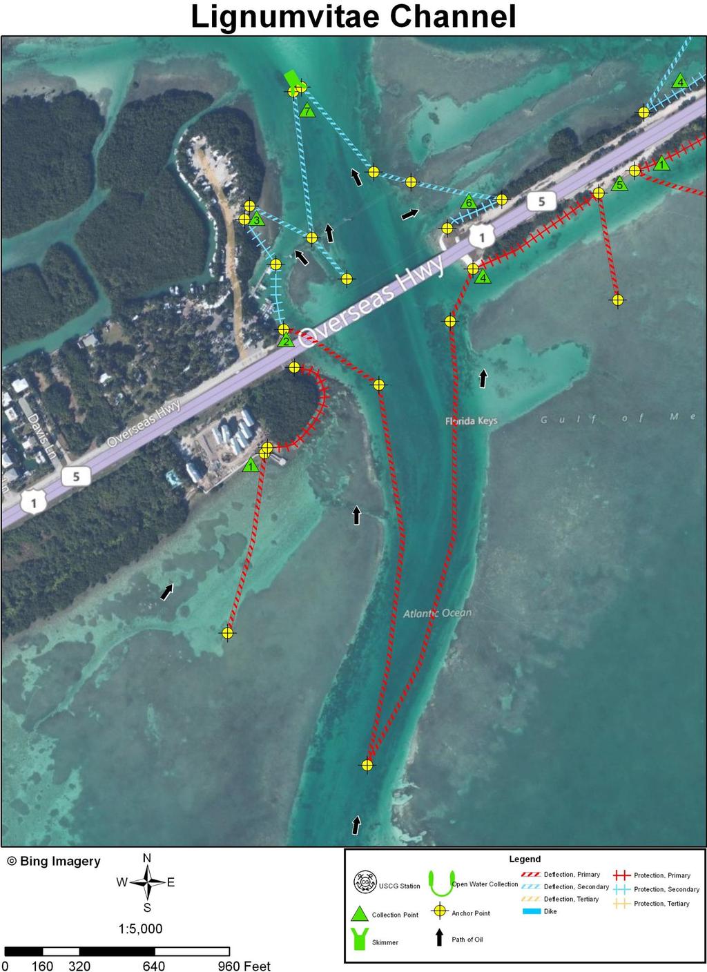
13 INLET SUMMARY SHEET SITE: Lignumvitae Channel, Monroe County, Florida DATE AND TIME OF ORIGINAL FIELD SURVEY [TIDE]: 23 June 1994; (+2.0); Alligator Reef Light] UPDATED: In October 2011 using imagery collected in 2010 and RANKING (DEGREE OF DIFFICULTY): B. (see ranking scale) PRINCIPAL RESOURCES AT RISK: Mangroves; wading birds, including the Great egret; and seabirds, including the Cormorant. Marina facilities, boats, seawalls, revetments, docks, etc. on Upper Matecumbe Key. For further information refer to the recent ESI map and data and the GRP. PRELIMINARY PROTECTION STRATEGY: Use deflection boom to divert oil out of the marginal flood channel area on the west side of the main inlet channel to a collection point against the concrete seawall on the shore of Lower Matacumbe Key (CP1). Establish deflection boom in a Christmas tree configuration with the lead anchor point being located in the main inlet channel about 800 yards south of the U.S. Route 1 Bridge. The west arm of the C. tree would divert oil out of the main inlet channel and to a seawall just beyond the southwest end of the Route 1 Bridge (on Lower Matacumbe Key; CP2) and the east arm would divert oil to the U.S. Route 1 fill shoreline to the east of the channel (CP4). Two short lines of deflection boom would divert oil to a sand beach located south of Route 1 about 300 yards beyond the northeast end of the bridge over the Lignumvitae Channel (CP5). Anchor a line of deflection boom in the main inlet channel just north of the bridge to divert oil to the sand beach at CP3. Place protection boom along the shorelines between CP1 and CP2 as well as between CP2 and CP3. Another line of deflection boom should extend from the inlet channel to the north side of Route 1 a ways beyond the northeast end of the bridge (CP6). Also, two lines of deflection boom should connect to an open water skimmer located in the main inlet channel about 300 yards north of the Route 1 Bridge. 73
14 INLET SUMMARY SHEET SITE: Lignumvitae Channel, Monroe County, Florida (continued) OTHER COMMENTS: Strong tidal current were observed flowing in channel beneath the U.S. Route 1 Bridge during the field survey in
15 75

16 Inlet: Lignumvitae Channel, Monroe County, Florida Site Name: Collection Point #1 Relative Location: South of U.S. Route 1 about a hundred yards west of the Route 1 Bridge over the Lignumvitae Channel. Latitude: 24 52' " N Longitude: 80 41' " W Currents: Possibly up to 1-3 knots to the northeast during rising tide. Shoreline Description: Rock seawall. Access: Excellent; you can drive right up to it. 76

17 Inlet: Lignumvitae Channel, Monroe County, Florida Site Name: Collection Point #2 Relative Location: Just north of the southwest end of the U.S. Route 1 Bridge over the Lignumvitae Channel. Latitude: 24 52' " N Currents: Possibly up to 2-3 knots. Shoreline Description: Concrete bulkhead. Longitude: 80 41' " W Access: Excellent; you can drive right up to it. Parking area nearby. 77

18 Inlet: Lignumvitae Channel, Monroe County, Florida Site Name: Collection Point #3 Relative Location: On west side of Lignumvitae Channel about 170 yards north of the Route 1 Bridge. Latitude: 24 53' 2.792" N Currents: Possibly up to 2-3 knots. Shoreline Description: Sand beach. Longitude: 80 41' " W Access: You can drive right up to it, but it is in a private development. Therefore, you may have to use watercrafts. 78
19 Inlet: Lignumvitae Channel, Monroe County, Florida Site Name: Collection Point #4 Relative Location: On south side of U.S. Route 1 just beyond the northeast end of the Route 1 Bridge over the Lignumvitae Channel. Latitude: 24 53' 0.293" N Longitude: 80 41' " W Water Depth Description: By ditch created by road construction. Currents: Possibly up to 2 knots. Shoreline Description: Mixture of sand, riprap, and mangroves (place protection boom along shore for oil to accumulate on). Access: You can drive close to it, but the mangroves are an issue. 79
20 Inlet: Lignumvitae Channel, Monroe County, Florida Site Name: Collection Point #5 Relative Location: On south side of U.S. Route 1 about 300 yards beyond the northeast end of the Route 1 Bridge over the Lignumvitae Channel. Latitude: 24 53' 3.585" N Longitude: 80 41' 9.176" W Water Depth Description: By a ditch created during the construction of the road. Currents: Possibly up to a knot or so. Shoreline Description: Sand beach with some rubble. Access: You can drive right up to it. 80

21 Inlet: Lignumvitae Channel, Monroe County, Florida Site Name: Collection Point #6 Relative Location: On north side of U.S. Route 1 just beyond the northeast end of the Route 1 Bridge over the Lignumvitae Channel. Latitude: 24 53' 2.726" N Currents: Probably not much more than 1-2 knots. Longitude: 80 41' " W Shoreline Description: Sand, riprap, and mangroves (place protection boom along shore for oil to accumulate on). Access: You can drive right up to it, but the mangroves may be an issue. 81

22 Inlet: Lignumvitae Channel, Monroe County, Florida Site Name: Collection Point #7; open water skimmer. Relative Location: In the main inlet channel about 300 yards north of the Route 1 Bridge. Latitude: 24 53' 7.526" N Longitude: 80 41' " W Currents: Possibly up to 2-4 knots. Shoreline Description: Open water skimmer. Access: By watercraft. 82
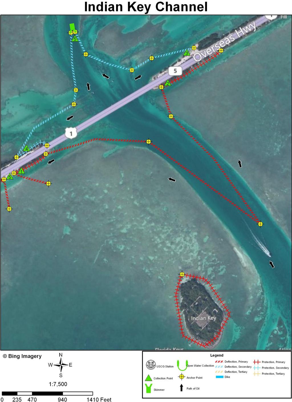
23 INLET SUMMARY SHEET SITE: Indian Key Channel, Monroe County, Florida DATE AND TIME OF ORIGINAL FIELD SURVEY [TIDE]: 23 June 1994; (+2.0); Alligator Reef Light] UPDATED: In October 2011 using imagery collected in 2010 and RANKING (DEGREE OF DIFFICULTY): B. (see ranking scale) PRINCIPAL RESOURCES AT RISK: Mangroves; wading birds, including the Great egret; and seabirds, including the Cormorant. For further information refer to the recent ESI map and data and the GRP. PRELIMINARY PROTECTION STRATEGY: Use deflection boom in a Christmas tree configuration to divert oil out of the main inlet channel and to collection points on the shore of the spoil island supporting U.S. Route 1 (CP1) and on the shore to the east of the northeast end of the Route 1 Bridge over Indian Key Channel (CP2). Also, use a limb of deflection boom to divert oil flowing west beyond the Route 1 Bridge to a collection point at a sand beach on the shoreline east of the bridge over Indian Key Channel (CP3). A similar line of deflection boom should be used to divert oil to the shoreline on the northwest side of the road beyond the west end of the bridge (CP4). These two lines of deflection boom should be extended into the main inlet channel to connect to an open water skimmer located about 650 yards northwest of the Route 1 Bridge. Also place protection boom around Indian Key to protect the mangroves. OTHER COMMENTS: Strong tidal current were observed flowing in channel beneath the U.S. Route 1 Bridge during the field survey in
24 67

25 Inlet: Indian Key Channel, Monroe County, Florida Site Name: Collection Point #1 Relative Location: On south side of U.S. Route 1, about 200 yards west of the west end of the bridge over Indian Key Channel. Latitude: 24 53' 4.402" N Currents: Probably less than 1 knot. Longitude: 80 41' 7.174" W Shoreline Description: Sand, riprap, and mangroves (place protection boom along shore for oil to accumulate on). Access: Excellent; you can drive right to it. 68

26 Inlet: Indian Key Channel, Monroe County, Florida Site Name: Collection Point #2 Relative Location: South of Route 1 just beyond the northeast end of the bridge over Indian Key Channel. Latitude: 24 53' " N Longitude: 80 40' " W Currents: Possibly as much as 1-2 knots. Shoreline Description: Sand, riprap, and mangroves (place protection along shore for oil to accumulate on). Access: Appears to be good; you can drive close to it. 69

27 Inlet: Indian Key Channel, Monroe County, Florida Site Name: Collection Point #3 Relative Location: On north side of Route 1 about 300 yards east of the end of the bridge over Indian Key Channel. Latitude: 24 53' " N Longitude: 80 40' " W Currents: Probably less than one knot. Shoreline Description: Sand beach plus some riprap. Access: Excellent; you can drive right to it. 70

28 Inlet: Indian Key Channel, Monroe County, Florida Site Name: Collection Point #4 Relative Location: On north side of U.S. Route 1 about 150 yards west of the west end of the Route 1 Bridge over Indian Key Channel. Latitude: 24 53' 7.882" N Longitude: 80 41' 6.220" W Currents: Possibly up to 1-2 knots. Shoreline Description: Sand, some riprap, and mangroves (place protection boom along shore for oil to accumulate on). Access: Excellent; you can drive right up to it. 71

29 Inlet: Indian Key Channel, Monroe County, Florida Site Name: Collection Point #5; open water skimmer. Relative Location: In Indian Key Channel about 600 yards northwest of the U.S. Route 1 Bridge. Latitude: 24 53' " N Longitude: 80 40' " W Water Depth Description: In main inlet channel. Currents: Possibly up to 2-3 knots. Shoreline Description: Open water skimmer. Access: By watercraft 72
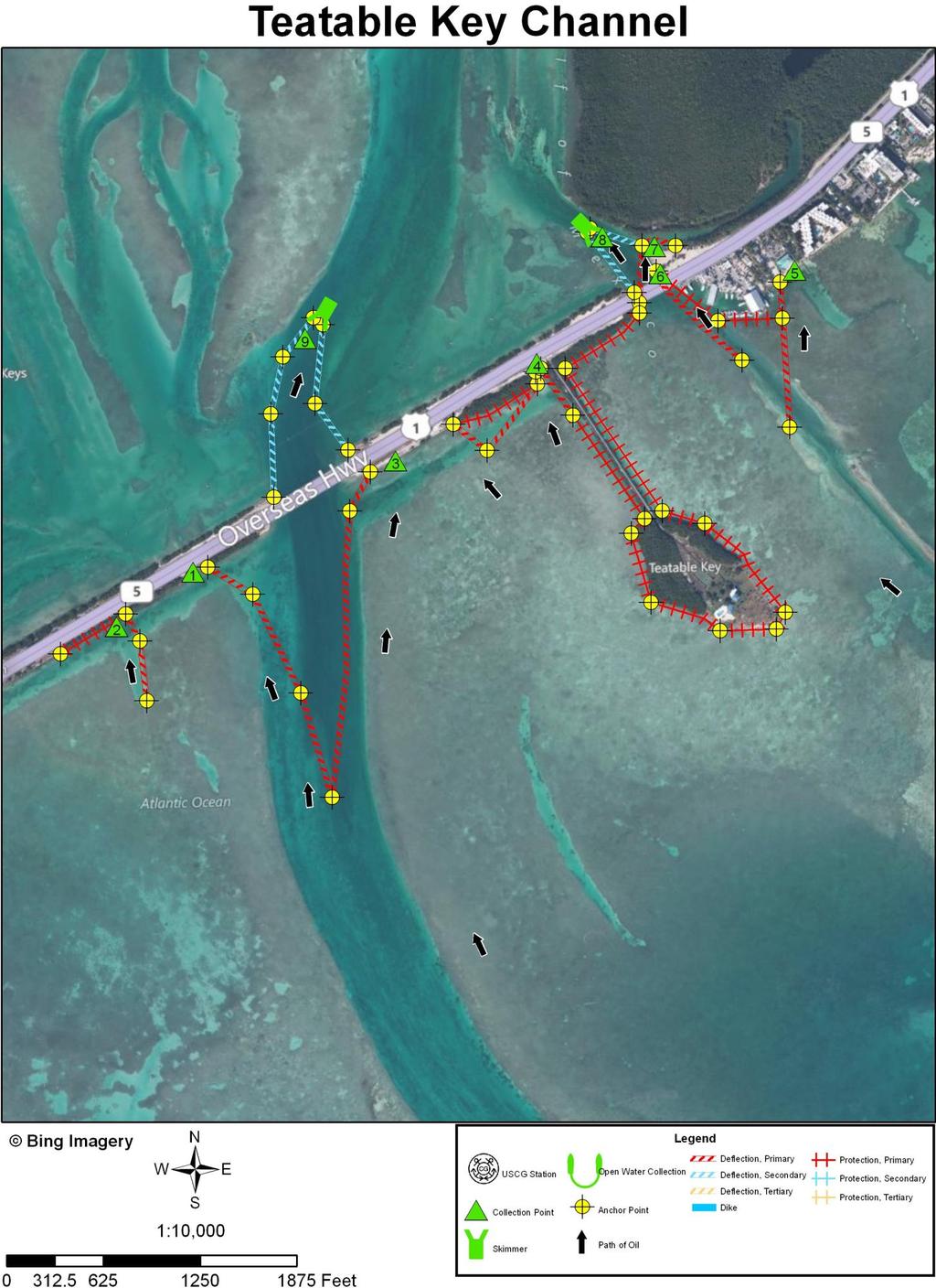
30 INLET SUMMARY SHEET SITE: Teatable Key Channel, Monroe County, Florida DATE AND TIME OF ORIGINAL FIELD SURVEY [TIDE]: 23 June 1994; (+2.0); Alligator Reef Light] UPDATED: In October 2011 using imagery collected in 2010 and RANKING (DEGREE OF DIFFICULTY): (see ranking scale) B. PRINCIPAL RESOURCES AT RISK: Mangroves; wading birds, including the Great egret; and seabirds, including the Cormorant. Marina facilities, boats, seawalls, revetments, docks, etc. on Upper Matecumbe Key. For further information refer to the recent ESI map and data and the GRP. PRELIMINARY PROTECTION STRATEGY: A short line of deflection boom could be extended along side a small channel to divert oil to a vegetated bank about 375 yards west of U.S. Route 1 Bridge over Teatable Key Channel (CP2). Use deflection boom in a Christmas tree configuration established in Teatable Channel, with the lead anchor located about 650 yards south of the U.S. Route 1 Bridge. The west limb of this C. tree would divert oil to a sand/mud flat on the side of Route 1 west of the bridge (CP1), and the east limb would divert oil to a seawall on the east side of the bridge (CP3). Establish a small Christmas tree configuration of deflection boom about half way between the main Teatable Key Channel and the road to Teatable Key. The west limb of this C. tree would divert oil to the seawall at CP3 and the right limb to a hard packed sand flat at CP4. Place protection boom in front of the vegetation along the shore between CPs 3 and 4. Entirely encircle Teatable Key and the road to it with protection boom, and extend this boom along the vegetation beside Route 1 to the short bridge over Teatable Relief Channel. Extend a line of deflection boom obliquely across the Teatable Relief Channel to divert oil to a sandy seawall/riprap area on Upper Matecumbe Key (CP5). Place protection boom around the marina area west of CP5. Extend another line of deflection boom across the Teatable Relief Channel in order to divert oil under the bridge over this channel to a riprap shoreline (shielded by protection boom upon which to divert the oil; in 54
31 INLET SUMMARY SHEET SITE: Teatable Key Channel, Monroe County, Florida (continued) PRELIMINARY PROTECTION STRATEGY (continued): CP6). Another line of deflection boon is extended across this channel westward of the bridge order to deflect oil into a basin with a seawall about 50 yards further along than CP6. This seawall is CP7. Attach another deflection boom to the one that leads to CP7 and extend it to the northwest back into the Teatable Relief Channel about 250 yards to an open water skimmer (CP8), which is also attached to a deflection boom extending along the west side of the channel from the west end of the Route 1 Bridge over Teatable Relief Channel. Finally, establish another open water skimmer attached to two lengths of deflection boom that is located in the Teatable Key Channel about 500 yards north of the Route 1 Bridge (CP9). OTHER COMMENTS: Strong tidal current were observed flowing in channel beneath the U.S. Route 1 Bridge during the field survey in
32 56

33 Inlet: Teatable Key Channel, Monroe County, Florida Site Name: Collection Point #1 Relative Location: About 200 yards southwest of the southwest end of the U.S. Route 1 Bridge. Latitude: 24 53' " N Longitude: 80 40' 7.395" W Currents: Possibly 1-2 knots. Shoreline Description: Sand/mud flat. Access: You can drive right to it. 57
.")
34 Inlet: Teatable Key Channel, Monroe County, Florida Site Name: Collection Point #2 Relative Location: About 400 yards to the southwest of the southwest end of the U.S. Route 1 Bridge. Latitude: 24 53' " N Currents: Not more than one knot. Longitude: 80 40' " W Shoreline Description: A vegetated bank (place a line of protection boom along it). Access: You can drive right to it. 58

35 Inlet: Teatable Key Channel, Monroe County, Florida Site Name: Collection Point #3 Relative Location: Near the east side of the U.S. Route 1 Bridge. Latitude: 24 53' " N Longitude: 80 39' " W Currents: Possibly 1-2 knots. Shoreline Description: Seawall. Access: You can drive right to it. 59
. Narrow.")
36 Inlet: Teatable Key Channel, Monroe County, Florida Site Name: Collection Point #4 Relative Location: By the road that leads to Teatable Key. Latitude: 24 53' " N Longitude: 80 39' " W Currents: Probably less than 1 knot. Shoreline Description: A hard packed sand flat (boat ramp??). Narrow. Access: You can drive right to it. 60

37 Inlet: Teatable Key Channel, Monroe County, Florida Site Name: Collection Point #5 Relative Location: On Upper Matecumbe Key about 200 yards east of the Route 1 Bridge over Teatable Relief Channel. Latitude: 24 53' " N Currents: Probably not more than 1 knot. Shoreline Description: sand/seawall/riprap. Longitude: 80 39' " W Access: There is a road right to it. May be a question of access because of private property. If not, use watercrafts. 61

38 Inlet: Teatable Key Channel, Monroe County, Florida Site Name: Collection Point #6 Relative Location: Under the Route 1 Bridge that crosses over Teatable Relief Channel. Latitude: 24 53' " N Longitude: 80 39' " W Water Depth Description: On the side of a fairly deep channel. Currents: Up to 2-4 knots. Shoreline Description: Riprap (place protection boom in front of it for oil collection). Access: You can drive right up to it. 62

39 Inlet: Teatable Key Channel, Monroe County, Florida Site Name: Collection Point #7 Relative Location: On the north side of the east end of the U. S. Route 1 Bridge over Teatable Relief Channel. Latitude: 24 53' " N Currents: Probably 2-4 knots. Shoreline Description: Seawall. Access: You can drive right up to it. Longitude: 80 39' " W 63

40 Inlet: Teatable Key Channel, Monroe County, Florida Site Name: Collection Point #8; open water skimmer. Relative Location: In Teatable Relief Channel 250 yards north of the U.S. Route 1 Bridge. Latitude: 24 53' " N Longitude: 80 39' " W Water Depth Description: In main inlet channel. Currents: Possibly 2-4 knots. Shoreline Description: Open water skimmer. Access: By watercraft. 64

41 Inlet: Teatable Key Channel, Monroe County, Florida Site Name: Collection Point #9; open water skimmer. Relative Location: In Teatable Key Channel 500 yards north of the U.S. Route 1 Bridge. Latitude: 24 53' " N Longitude: 80 39' " W Water Depth Description: In main inlet channel. Currents: Possibly 2-4 knots. Shoreline Description: Open water skimmer. Access: By watercraft. 65
Geographic Response Plan Map: SFL-21. Map continued on: SFL-31S XXX. k Curry Hammock. SFL21-05 Grassy Key Beaches. Map continued on: SFL-20
 ! 81 0'0"W Geographic Response Plan Map: SFL-21 Map continued on: SFL-31S 80 52'30"W Arse XXX S A 24 52'30"N j Everglades National Park [] [ 24 52'30"N Florida Bay Flo Nati S 9N-01 oo Banks ock 54! Bamboo
Geographic Response Plan Map: SFL-19. Map continued on: SFL-19N. Vaca Key. Hawk Channel. Reef Monitoring Site. Florida Keys.
 !!! L18-01 thel Bank en X! 46 e) igeon 24 45'0"N Bethel Bank XXX Map continued on: SFL-18 81 7'30"W 47! # 450 SFL19-04 Boot Inlet SFL19N-02 John Sawyer Bank 100 SFL19-05 Sister Creek - Boot, FL Rachel
Geographic Response Plan Map: SFL-26. Map continued on: SFL-28. Florida Keys. Wildlife and Environmental. ! k. Area. Plantation Key.
 !!!!!!!!!!!!!!!!!!!!!!!!!!!!!!!! u Cotton Key lamorada f!. ey 4550 SFL26-03 Cotton Key 82! 2750 SFL25-05 Upper Matecumbe Beach ey 25 0'0"N Map continued on: SFL-25 tic Ocean 24 52'30"N 80 37'30"W XXX 1700!
Geographic Response Plan Map: EFL-25. Map Continued on Page: EFL-30. EFL25-01 Cape Canaveral Air Force Station Nesting Beach - South
 r. 80 37'30"W Banana River 28 30'0"N!d! White Geographic Response Plan Map: EFL-25 Point Map Continued on Page: EFL-30 80 30'0"W 28 30'0"N! Cactus Point a th)! er erve Map Continued on Page: EFL-26!S(!d
Geographic Response Plan Map: EFL-13NW AB 608 AB 5 1 AB 68 ") 770. !Å Heliport [ Historical!Å Site!(RSeagrass! Manatee
 770. !Å Heliport [ Historical!Å Site!(RSeagrass! Manatee") ! 27 30'0"N 80 22'30"W! Geographic Response Plan Map: EFL-13NW [k Indian River - Vero Beach to Ft. Pierce Aquatic Preserve Ft. Pierce State Park [k J a c k I s l a n d 80 18'45"W [\ 27 30'0"N ]^607A ")
! 27 30'0"N 80 22'30"W! Geographic Response Plan Map: EFL-13NW [k Indian River - Vero Beach to Ft. Pierce Aquatic Preserve Ft. Pierce State Park [k J a c k I s l a n d 80 18'45"W [\ 27 30'0"N ]^607A ")
Geographic Response Plan Map: EFL-9. Map continued on: EFL-11 #[\ [\ H u t c h i n s o n I s l a n d XXX XXX
 OUNTY r South h t. r 1200 27 15'0"N!] Map continued on: EFL-10 27 7'30"N 80 15'0"W Environmentally Sensitive Areas Summer Protection Priority A - Protect First B - Protect after A Areas XX X C - Protect
EFL Map Continued on Page: EFL-54 FXXXEFL Nassau Sound XXX. Nassau Sound. Little Talbot. Big Talbot A1A. r rg. Ft.
 Ecological & Historic Preserve c 900 ou Nassau C ounty C l a v Du Nassau Sound Geographic Response Plan Map: EFL-55 EFL-56-06 # t k S EFL-56 F XXonXPage: ( Map Continued d Nassau Sound \ «- Bird Island
Geographic Response Plan Map: SFL-54. !d [\ AB A1A XXX. SFL54-04 Boca Raton Inlet/ Lake Boca Raton XXX. SFL Site 3.
 26 22'30"N Map continued on: SFL-55 26 15'0"N 80 7'30"W Environmentally Sensitive reas Bio-Socioeconomic Summer Protection Priority - Protect First [\ Beach ccess B - Protect after reas [m irport XXX XX
XXX. Chisolm Island Creeks. Map Continued on SC-48. Judge Island. SC49-03 Jenkins Creek/Morgan River Intersection XXX. Saint Helena Island
 w River 32 30'0"N ufort County 80 37'30"W 802 Coosaw River 250 450 SC41-05 Geographic Response SC41-03 Plan Map: Coosaw SC-49 River Chisolm Island Chisolm Island s u Map Continued on SC-41 3 (west side)
Geographic Response Plan Map: VI-7 Inset Map A567 TRUNK AND HAWKSNEST BAYS XXX. St. John. qxxxa551 - V.I. WAPA WATERINTAKE, Acropora Priority Sites
 Geographic Response Plan Map: VI-7 Inset Map Whistling Cay Virgin Islands National Park j St. John qa551 - V.I. WAPA WATERINTAKE, Great Cruz FRANK BAY # St. St. n Jo h s a om Th A554 CHOCOLATE HOLE FISH
Geographic Response Plan Map: SC-35 Pleasant Point. Map Continued on SC-36. SC35-05 Church Flats Creek. SC35-01 Mouth of Stono River XXX.
 wood [ 34-01 ogoodoo ek 32 45'0"N Map Continued on SC-34 32 37'30"N 80 15'0"W [y [ 80 15'0"W «165 «165 Meggett SC35-04 Wadmalaw River Wadmalaw River «165 Hollywood Martins Point [ SC35-03 Oyster House
Geographic Response Plan Map: SC-41 ACE BASIN NERR. u [b. Big Island. SC47-08 Old Chehaw. River SC Bull River XXX
 32 37'30"N 80 37'30"W Geographic Response Plan Map: SC-41 Map Continued on SC-33W ACE BASIN NERR 80 30'0"W 32 37'30"N!d Old Chehaw Ashepoo Map Continued on SC-40 32 30'0"N y Schooner Channal 80 37'30"W
Geographic Response Plan Map: SC-17
 79 37'30"W Geographic Response Plan Map: SC-17 79 30'0"W 33 7'30"N Charleston County 33 7'30"N 33 0'0"N 79 37'30"W [ Awendaw [j [e!d!s(!d Graham Creek FRANCIS MARION NATIONAL FOREST 450 Awendaw Creek [j
BookletChart. Intracoastal Waterway Matecumbe to Grassy Key NOAA Chart A reduced-scale NOAA nautical chart for small boaters
 BookletChart Intracoastal Waterway Matecumbe to Grassy Key NOAA Chart 11449 A reduced-scale NOAA nautical chart for small boaters When possible, use the full-size NOAA chart for navigation. Published by
Chief-Planning & Readiness USCG Sector Houston-Galveston
 Boom Efficacy During the DEEPWATER HORIZON Response LCDR Joseph J. Leonard, Jr. Chief-Planning & Readiness USCG Sector Houston-Galveston June 2011 Boom Selection Responder Skill Sets Boom Utilization Site
Geographic Response Plan Map: VI-1. Maroon Hole Annaly Bay. Hams Bluff. Bay B515 FREDERIKSTED PIER A518 - LONG POINT BAY BEACHES AND SALT POND ( ^
 Geographic Response Plan Map: VI-1 64 52'3W A512 - DAVIS BAY BEACH CARAMBOLA BEACH RESORT) Maroon Hole Annaly Hams Bluff A511 CANE BAY XXX ^7 XXX # ^ 5 4 Cane 17 45'N 17 45'N Butler Hams Caribbean Sea
GOAL: Collect product flowing over Onalaska spillway to protect downstream resources C&C 250 Y Y. Looking upstream at spillway
 GOAL: Collect product flowing over Onalaska spillway to protect downstream resources BR5 Black n/a Onalaska Spillway Carry- In C&C 250 Y Y Looking upstream at spillway Implementation (Go to Aerial View)
Project Webpage:
 Project Webpage: http://nature.ly/marinesatlanticbightera Coastal Data and Full Metadata: http://easterndivision.s3.amazonaws.com/marine/sab MA/SABMACoastalEcosystems.zip Coastal Chapter: http://easterndivision.s3.amazonaws.com/marine/sab
HARBOR INFRASTRUCTURE INVENTORIES West Harbor, OH
 HARBOR INFRASTRUCTURE INVENTORIES West Harbor, OH Harbor Location: West Harbor is located on the southern shore of Lake Erie in the township of Catawba Island, OH about 50 miles east of Toledo, OH. Authority:
AGENCY/ORGANIZATION OFFICE/DIVISION SECTION/SUBSECTION ACTIONS (Related to Coral Reefs) Natural Resources Planning and Management Division
 Natural Resources Planning and Management Division") AGENCY/ORGANIZATION OFFICE/DIVISION SECTION/SUBSECTION ACTIONS (Related to Coral Reefs) Broward County Environmental Protection and Growth Department Natural Resources Planning and Division Broward County
AGENCY/ORGANIZATION OFFICE/DIVISION SECTION/SUBSECTION ACTIONS (Related to Coral Reefs) Broward County Environmental Protection and Growth Department Natural Resources Planning and Division Broward County
no-take zone 1 of 5 Channel Islands National Marine Sanctuary, California
 This website would like to remind you: Your browser (Apple Safari 4) is out of date. Update your browser for more security, comfort and the best experience on this site. Encyclopedic Entry no-take zone
Species Conclusions Table
 Conclusions Table Project Name: Chesapeake Landing HOA- Breakwaters (NAO-14-0283) Date: February 25, 2014 /Resource Name Loggerhead sea turtle (Caretta caretta) Conclusion ESA Section 7 / Eagle Act Determination
MIAMI-DADE COUNTY MANATEE PROTECTION AREAS AND BOATING RESTRICTED AREAS
 MANATEE PROTECTION AREAS AND BOATING RESTRICTED AREAS For description of zone boundaries see: 68C-22.025 F.A.C for State Manatee Protection Zones last amended 2/25/99 68D-24.03 F.A.C. for State Boating
South Florida Algal Bloom Sampling Results July
 South Florida Algal Bloom Sampling Results July Sample Date Samples Collected By Samples Analyzed By Sampling Location (Latitude and Longitude) Depth (Meters) Algae ID (Type of Blue Green Algae) Microcystin
East Central Florida Region Matt Culver, Brevard County James Gray, Indian River County Jim Oppenbourn, St. Lucie County Kathy Fitzpatrick, Martin
 James Gray, Indian River County January 14, 2015 East Central Florida Region Matt Culver, Brevard County James Gray, Indian River County Jim Oppenbourn, St. Lucie County Kathy Fitzpatrick, Martin County
Invasive Species. No, not aliens from outer space!
 Invasive Species No, not aliens from outer space! Next Generation Science Standards This lesson about invasive species incorporates real data and tools used by Gulf of Mexico scientists and resource managers.
Barge MM 46 Response Natchez, MS Lower Mississippi River Mile Marker 363
 UNCLASSIFIED Barge MM 46 Response Natchez, MS Lower Mississippi River Mile Marker 363 UNCLASSIFIED RRT Activation: Type of Product & Amount spilled: Cause of Spill: None Catalytic Cracked Clarified Oil
MEMORANDUM. Existing Operations. City of Clearwater. Michael Herrman. Date: January 26, Seminole Boat Launch Overview. M&N Job No.
 1509 W. Swann Avenue, Suite 225 Tampa, FL 33606 (813) 258-8818 Fax (813) 258-8525 www.moffattnichol.com MEMORANDUM To: From: City of Clearwater Michael Herrman Date: Subject: Seminole Boat Launch Overview
HARBOR INFRASTRUCTURE INVENTORIES Oak Orchard Harbor, New York
 HARBOR INFRASTRUCTURE INVENTORIES Oak Orchard Harbor, New York Harbor Location: Oak Orchard Harbor is located on the southern shore of Lake Ontario at the mouth of Oak Orchard Creek in the village of Point
SECTION II NM 11/13 NAVIGATION PUBLICATIONS COAST PILOT CORRECTIONS. Chapter 4 Paragraphs 85 to 86; read: (85)
") NAVIGATION PUBLICATIONS COAST PILOT CORRECTIONS COAST PILOT 1 42 Ed 2012 Change No. 13 LAST NM 9/13 Chapter 4 Paragraph 9; read: (9) Round Rock, which uncovers, and The Boring Stone, 3 feet high and bare,
NAVIGATION PUBLICATIONS COAST PILOT CORRECTIONS COAST PILOT 1 42 Ed 2012 Change No. 13 LAST NM 9/13 Chapter 4 Paragraph 9; read: (9) Round Rock, which uncovers, and The Boring Stone, 3 feet high and bare,
WALTON COUNTY NRDA ARTIFICIAL REEF PROGRAM
 WALTON COUNTY NRDA ARTIFICIAL REEF PROGRAM Melinda Gates Lauren Floyd Kathryn Brown Beau Suthard, PG Franky Stankiewicz Walton County - Coastal Resource Liaison APTIM - Senior Marine Biologist APTIM -
Cat Island Chain Restoration
 Cat Island Chain Restoration 1820s Fox River Military Road Map to Fort Howard 1845 Chart of Green Bay & Fox River Cat Island Chain - 1938 Cat Island Brown County Aerial Photography, 1938 Historic Western
Canoe Route. Dogtooth Lake-Highwind Lake-Dryberry Lake- Lake of the Woods-Blindfold Lake
 1 Canoe Route Dogtooth Lake-Highwind Lake-Dryberry Lake- Lake of the Woods-Blindfold Lake This is an interesting and challenging route starting and ending at Rushing River Provincial Park. It passes over
Abandoned and Derelict Vessels in the Florida Keys National Marine Sanctuary
 Abandoned and Derelict Vessels in the Florida Keys National Marine Sanctuary Steve Werndli Emergency Response and Enforcement Coordinator Florida Keys National Marine Sanctuary April 18, 2017 Derelict
HARBOR INFRASTRUCTURE INVENTORIES Fairport Harbor, OH
 HARBOR INFRASTRUCTURE INVENTORIES Fairport Harbor, OH Harbor Location: Fairport Harbor is located at the mouth of the Grand River on the southern shore of Lake Erie in the city of Fairport, OH, approximately
VIDEO TRANSCRIPT. A Proposal to Expand the Flower Garden Banks National Marine Sanctuary An interview with Sanctuary Superintendent, G.P.
 VIDEO TRANSCRIPT A Proposal to Expand the Flower Garden Banks National Marine Sanctuary An interview with Sanctuary Superintendent, G.P. Schmahl (Opening scene of Flower Garden Banks National Marine Sanctuary
GEM Network; Færoe Islands Coastal Protection Plans. REGION 1. Viðoy. DATE OF SURVEY: October 2000
 REGION 1. Viðoy DATE OF SURVEY: October 2000 General Description of the Area including Tidal Information This region consists of the northern parts of Borðoy, Kalsoy, Kunoy, Svínoy as well as Fugloy. Borðoy
Oil Spill Incident Annex. Introduction [Link to the Oil and Hazardous Materials Incident Annex in the NRP]
![Oil Spill Incident Annex. Introduction [Link to the Oil and Hazardous Materials Incident Annex in the NRP]](/thumbs/89/100738091.jpg "Oil Spill Incident Annex. Introduction [Link to the Oil and Hazardous Materials Incident Annex in the NRP]") Introduction [Link to the Oil and Hazardous Materials Incident Annex in the NRP] Response to oil spills can vary greatly, involving only a few people or thousands. The initial action taken by responders
Introduction [Link to the Oil and Hazardous Materials Incident Annex in the NRP] Response to oil spills can vary greatly, involving only a few people or thousands. The initial action taken by responders
Wexford Harbour. Yachting Guide. Navigation
 Wexford Harbour Yachting Guide Navigation This document supersedes all previous editions. Approvals: Yacht Club Committee April, 2015 Wexford Board of Directors April, 2015 # Date Section Revision 1 6.5.2015
Conservation and Restoration Florida s Coastal Marshes: An Overview of MESS. Jeff Beal, Kent Smith, Erin McDevitt, Maria Merrill
 Conservation and Restoration Florida s Coastal Marshes: An Overview of MESS Jeff Beal, Kent Smith, Erin McDevitt, Maria Merrill FWC s MESS: -Marine/Estuarine Subsection -within Aquatic Habitat Conservation
Admiralty Inlet Pilot Tidal Project FERC No Appendix C. Derelict Gear Monitoring Plan
 Appendix C Derelict Gear Monitoring Plan ADMIRALTY INLET PILOT TIDAL PROJECT FERC PROJECT NO. 12690 DERELICT GEAR MONITORING PLAN (submitted with the Final Application for a New Pilot Project License)
Issues facing this region include the status of the Sluice Creek tide gates, various tidal wetlands, and locations of public access:
 5.6 Guilford Point to Madison Town Line Existing Resources This region extends from Guilford Point to the Madison town line. Named places include Grass Island and the East River. Residential, commercial,
Expanding Anchoring Away
 Expanding Anchoring Away Vessel taxonomy &territorial waters Maritime and admiralty law distinguished The right to navigate Federal navigational servitude as applied CZMA, reverse federalism & Florida
MIAMI-DADE COUNTY MANATEE PROTECTION AREAS
 MANATEE PROTECTION AREAS For description of zone boundaries see: 68C-22.025 F.A.C for State Manatee Protection Zones last amended 2/25/99 For infomation please call or write to: Fish and Wildlife Conservation
REGION 2. Eysturoy (north)
") REGION 2. Eysturoy (north) DATE OF SURVEY: October 2000 General Description of the Area including Tidal Information The region consists of the northern part of Eysturoy, within which are the coastal villages
REGION 2. Eysturoy (north) DATE OF SURVEY: October 2000 General Description of the Area including Tidal Information The region consists of the northern part of Eysturoy, within which are the coastal villages
BlueRider OCEAN AWARENESS. Toolkit for Enhancing Visitors Experiences in the Florida Keys Aboard Personal Watercraft AND STEWARDSHIP PROGRAM
 BlueRider OCEAN AWARENESS AND STEWARDSHIP PROGRAM www.pwia.org/bluerider/default.aspx Toolkit for Enhancing Visitors Experiences in the Florida Keys Aboard Personal Watercraft Important Links» Florida
ST. LUCIE COUNTY, FLORIDA
 ST. LUCIE COUNTY, FLORIDA COASTAL STORM RISK MANAGEMENT STUDY Draft Feasibility Study & Integrated Environmental Assessment Public Meeting Presented by U.S. Army Corps of Engineers Jacksonville District
Evolution of Deepwater Coral Protection in the Southeast U.S
 Evolution of Deepwater Coral Protection in the Southeast U.S Tina Udouj, Florida Fish and Wildlife Conservation Commission Roger Pugliese, South Atlantic Fishery Management Council Overview Deepwater Corals
WHAT ARE ECOSYSTEMS? Dr. V. N. Nayak Professor of Marine Biology (Retd)
") WHAT ARE ECOSYSTEMS? Dr. V. N. Nayak Professor of Marine Biology (Retd) An ECOSYSTEM is an interacting system of plant, animals, and humans and the surrounding environment. An ecosystem contains living
WHAT ARE ECOSYSTEMS? Dr. V. N. Nayak Professor of Marine Biology (Retd) An ECOSYSTEM is an interacting system of plant, animals, and humans and the surrounding environment. An ecosystem contains living
Case Study: Merritt Island National Wildlife Refuge
 Case Study: Merritt Island National Wildlife Refuge Read the case study below. As you read, complete the Case Study Notetaking worksheet. Geography Cape Canaveral is on the east coast of Florida, roughly
IF YOU BUILD IT THEY WILL COME
 IF YOU BUILD IT THEY WILL COME Delaware s Artificial Reef Program is funded under the Federal Aid in Fisheries Restoration Act by the Delaware Division of Fish and Wildlife ABOUT THE COVER The tugs Fels
Indian River Lagoon: Lessons, Challenges and Opportunities
 Indian River Lagoon: Lessons, Challenges and Opportunities Upper Chain of Lakes Lake Kissimmee Kissimmee River Indian River Lagoon Caloosahatchee Estuary Lake Okeechobee St. Lucie Estuary Mark Perry, Executive
HARBOR INFRASTRUCTURE INVENTORIES Muskegon Harbor, Michigan
 HARBOR INFRASTRUCTURE INVENTORIES Muskegon Harbor, Michigan Harbor Location: Muskegon Harbor is located on the east shore of Lake Michigan, 114 miles northeast of Chicago, IL. Authority: River & Harbor
Proposed Terrestrial Critical Habitat for the Northwest Atlantic Loggerhead Sea Turtle Population. U.S. Fish and Wildlife Service
 Proposed Terrestrial Critical Habitat for the Northwest Atlantic Loggerhead Sea Turtle Population U.S. Fish and Wildlife Service History of Loggerhead Listing (joint responsibility USFWS and NOAA Fisheries)
This training is intended to be educational and should not be construed as legal guidance. It is provided as a courtesy to our customers and others
 June 2012 This training is intended to be educational and should not be construed as legal guidance. It is provided as a courtesy to our customers and others who may benefit from the information contained
GONE! Coastal Erosion Happens During Storms! Why Worry About Coastal Setbacks? Goals for Today
 RI Regulatory Setbacks & Buffers: Coastal Zone Management Issues New England Onsite Wastewater Training Program @ URI OWT 155 November 21, 2013 Goals for Today Understand the impacts of storms, coastal
For more information or permission to reprint slides, please contact Donna Milligan at 1
 For more information or permission to reprint slides, please contact Donna Milligan at milligan@vims.edu 1 For more information or permission to reprint slides, please contact Donna Milligan at milligan@vims.edu
Citizen Science Based Survey GBR Far North Dive Trip 2016 April 18-26
 Citizen Science Based Survey GBR Far North Dive Trip 2016 April 18-26 Chris Roelfsema Karen Johnson Douglas Stetner Trevor Baerenger Peran Brady May 2016 GBR Far North Citizen Science Trip 5 May 2016 1
RI Regulatory Setbacks & Buffers: Coastal Management Issues
 RI Regulatory Setbacks & Buffers: Coastal Management Issues New England Onsite Wastewater Training Program @ URI OWT 155 - November 29, 2012 James Boyd - Coastal Policy Analyst Photo: October 30, 2012
9. SHORELINE PROTECTION
 9. Shoreline protection is defined as those response activities that take place at or near the shoreline, rather than on open water, to protect the shore zone from becoming oiled or to protect vulnerable
Initial recovery of flora and fauna at restored mosquito impoundments in Indian River Lagoon, FL
 Initial recovery of flora and fauna at restored mosquito impoundments in Indian River Lagoon, FL Melinda Donnelly PhD Candidate, University of Central Florida Ron Brockmeyer, Linda Walters, William Greening,
M/V SELENDANG AYU. Unalaska Island, Alaska
 M/V SELENDANG AYU Unalaska Island, Alaska December 2004 1 Characteristic Aleutians Response Foreign flag vessel on innocent passage Lack of spill response vessels Economically important fisheries Subsistence
Pacific States Marine Fisheries Commission 63 rd Annual Meeting
 Pacific States Marine Fisheries Commission 63 rd Annual Meeting John Oliver Deputy Assistant Administrator for Fisheries August 23, 2010 2 NOAA Fisheries Service Organization Deputy Assistant Administrator
Surfrider s Recreational Use Survey and Marine Spatial Planning in Washington State. Gus Gates- WA Policy Manager
 Surfrider s Recreational Use Survey and Marine Spatial Planning in Washington State Gus Gates- WA Policy Manager Overview Background on MSP and Rec Study Stakeholder outreach Collaboration w/ OCNMS staff
National Oceanic and Atmospheric Administration (NOAA)/ Mulberry Phosphate Trustee Council September 12, 2013
/ Mulberry Phosphate Trustee Council September 12, 2013") OYSTER REEF CREATION PROJECT DESIGN AND IMPLEMENTATION IN HILLSBOROUGH BAY, FLORIDA TAMPA BAY REGIONAL PLANNING COUNCIL AGENCY ON BAY MANAGEMENT MEETING National Oceanic and Atmospheric Administration
OYSTER REEF CREATION PROJECT DESIGN AND IMPLEMENTATION IN HILLSBOROUGH BAY, FLORIDA TAMPA BAY REGIONAL PLANNING COUNCIL AGENCY ON BAY MANAGEMENT MEETING National Oceanic and Atmospheric Administration
***This summary does not include shad and herring net requirements.***
 South Carolina Department of Natural Resources Marine Resources Division Summary of Seine and Gill Net Laws (Saltwater) 2013-2014 This document should be kept on board all vessels using seines or gill
Lee E. Harris, Ph.D., P.E. Assoc. Professor of Ocean Engineering. Doug Bowlus and Ashley Naimaster Ocean Engineering Graduate Students
 FLORIDA TECH OCEAN ENGINEERING PROFESSOR LEE HARRIS AND HIS GRADUATE STUDENTS ASSIST WITH POST-HURRICANE IVAN CORAL REEF RESTORATION IN THE CAYMAN ISLANDS Lee E. Harris, Ph.D., P.E. Assoc. Professor of
Coastal Harbors and Waterways, NC (Shallow Draft Navigation) (O&M)
 (O&M)") Coastal Harbors and Waterways, NC (Shallow Draft Navigation) (O&M) Shallow draft coastal harbors include a subsistence harbor at Silver Lake CONGRESSIONAL DISTRICT: NC 3, 7 DATE: 23 April 2018 1. AUTHORIZATION:
Coastal Harbors and Waterways, NC (Shallow Draft Navigation) (O&M) Shallow draft coastal harbors include a subsistence harbor at Silver Lake CONGRESSIONAL DISTRICT: NC 3, 7 DATE: 23 April 2018 1. AUTHORIZATION:
HARBOR INFRASTRUCTURE INVENTORIES Marquette Harbor, Michigan
 HARBOR INFRASTRUCTURE INVENTORIES Marquette Harbor, Michigan Harbor Location: Marquette Harbor is located in Marquette Bay on the south shore of Lake Superior, 160 miles west of Sault Ste. Marie, MI and
Marine Ecosystems. Aquatic Ecosystems Section 2
 Marine Ecosystems Marine ecosystems are located mainly in coastal areas and in the open ocean. Organisms that live in coastal areas adapt to changes in water level and salinity. Organisms that live in
Nautical Chart Challenge
 Discover Your World With NOAA Nautical Chart Challenge For as long as anyone in his family could remember, Francis Beaufort wanted to make scientific observations from the deck of a ship. In 1789 at the
JUNE 2018 RECREATIONAL SHRIMPING REGULATIONS
 K STATE OF ALABAMA DEPARTMENT OF CONSERVATION AND NATURAL RESOURCES MARINE RESOURCES DIVISION POST OFFICE BOX 189 DAUPHIN ISLAND, AL 36528 TEL (251) 861-2882 FAX (251) 861-8741 JUNE 2018 RECREATIONAL SHRIMPING
VOLUME IV FLORIDA KEYS AREA CONTINGENCY PLAN WILDLIFE RESPONSE PLAN / MARINE ANIMAL FACILITIES PLAN
 VOLUME IV FLORIDA KEYS AREA CONTINGENCY PLAN WILDLIFE RESPONSE PLAN / MARINE ANIMAL FACILITIES PLAN VOLUME IV FLORIDA KEYS AREA CONTINGENCY PLAN WILDLIFE RESPONSE PLAN/MARINE ANIMAL FACILITIES PLAN THIS
BookletChart. Sand Key to Rebecca Shoal NOAA Chart A reduced-scale NOAA nautical chart for small boaters
 BookletChart Sand Key to Rebecca Shoal NOAA Chart 11439 A reduced-scale NOAA nautical chart for small boaters When possible, use the full-size NOAA chart for navigation. Published by the National Oceanic
Puget Sound Nearshore Ecosystem Restoration Project Restore America s Estuaries Conference 2012 Tampa, FL
 Restore America s Estuaries Conference 2012 Tampa, FL presented by: Theresa Mitchell, WA Dept. of Fish & Wildlife Nearshore General Investigation Change Analysis: Comparison of historical and current
HARBOR INFRASTRUCTURE INVENTORIES Caseville Harbor, Michigan
 HARBOR INFRASTRUCTURE INVENTORIES Caseville Harbor, Michigan Harbor Location: Caseville Harbor is located at the mouth of the Pigeon River on the east shore of Saginaw Bay, about 17 miles southwest of
Nicholas Brown. 31 Bennett Rd Wolfeboro NH Application submitted
 Nicholas Brown 31 Bennett Rd Wolfeboro NH 03894 603-856-5454 Nick4634@gmail.com Application submitted 8-12-2017 Description of proposed project A. General Methodology The site located approximately 600
West Coast Anchorages
 West Coast Anchorages This document aims to catalogue a number of anchorages along the West Coast of Tasmania where shelter may be sought. In addition the degree of protection from the wind, and holding
Using This Guide. Latitude and longitude lines are indicated in white (see next page for complete legend).
.") Using This Guide This guide is divided into 13 sections. Each section is approximately 5 miles long. The detailed maps contain mileage figures and GPS points. Distances on the map are approximate. Your
Using This Guide This guide is divided into 13 sections. Each section is approximately 5 miles long. The detailed maps contain mileage figures and GPS points. Distances on the map are approximate. Your
Florida Keys National Marine Sanctuary
 Florida Keys National Marine Sanctuary Review of the Marine Zones and Regulations [insert your name here] [insert your email here] Florida Keys National Marine Sanctuary 2900 nm 2 / 10,000 km 2 Jurisdiction
Assessment of Artificial Reefs Impacted by Hurricane Michael
 Assessment of Artificial Reefs Impacted by Hurricane Michael Jeff Renchen, Keith Mille, Devin Resko, Christine Kittle Florida Fish and Wildlife Conservation Commission Division of Marine Fisheries Management
Estuarine Shoreline Stabilization
 Estuarine Shoreline Stabilization Property Owner s Guide to Determining the Most Appropriate Stabilization Method Estuarine shorelines are dynamic features that experience continued erosion. Land is lost
Another essential characteristic of boat channel geography is the form and spacing of channel
 Another essential characteristic of boat channel geography is the form and spacing of channel segments.some channels are simple, and others are complex. The channel systems include: finger canals or basins;
Rising Tide Oyster Company 2.0 Acre Bellamy Site Marine Aquaculture License Application
 Rising Tide Oyster Company 2.0 Acre Bellamy Site Marine Aquaculture License Application Joshua and Jessica Carloni 264 Swain Road Barrington, N.H. 03825 Summary This is an amendment to our existing license
The 2010 BP Oil Disaster Pacific States Marine Fisheries Commission 63 rd Annual Meeting August 24, 2010
 The 2010 BP Oil Disaster Pacific States Marine Fisheries Commission 63 rd Annual Meeting August 24, 2010 Larry Simpson Gulf States Marine Fisheries Commission Oil Spill On April 20, 2010, the Deepwater
ADL Attachment 1
 (formerly) 106502 Kina Cove A reapplication for an expired lease. The type of commercial use is identical to that previously. The immediate off-shore tidelands will be used to dump, raft, and store round
Go to Reference with Economic Statistics for US by Region and State. NOAA summary of fisheries of the US by state
 Go to Reference with Economic Statistics for US by Region and State Fisheries Economics of the United States 2014 Economics and Sociocultural Status and Trends Series U.S. Department of Commerce National
Hatfield Marine Science Center Nature Trail Quest
 Hatfield Marine Science Center Nature Trail Quest 118 The Oregon Coast Book, 2019 20 Edition South Beach NOAA Marine Operations Center Marina Store HMSC HMSC Tsunami Sustainability Quest Quest START START
Chart Features Maritime maps and Admiralty charts have these features:
 Introduction to Charts A chart or map of the area is an important safety item to carry on board. It allows the Master to obtain knowledge of the area to be travelled, and indicates the navigable channels
U. S. Coast Guard Sector Boston Merrimack River Approach and Entrance, MA. Waterways Management Survey
 U. S. Coast Guard Sector Boston Merrimack River Approach and Entrance, MA. Waterways Management Survey The Waterways Analysis and Management Survey (WAMS) process is an essential component of both the
Florida s Artificial Reef Monitoring Efforts
 Florida s Artificial Reef Monitoring Efforts Prepared by Keith Mille March 14, 2016 Dive assessment of the Oriskany Reef, October 2006. Photo by Keith Mille Florida Fish and Wildlife Conservation Commission
Florida Seagrass Integrated Mapping and Monitoring Program
 Florida Seagrass Integrated Mapping and Monitoring Program - 2004 The following document is composed of excerpts taken from the 2011 publication, Seagrass Integrated Mapping and Monitoring for the State
NORTH OREGON COAST GEOGRAPHIC RESPONSE PLAN (GRP)
") Northwest Area Committee NORTH OREGON COAST GEOGRAPHIC RESPONSE PLAN (GRP) AREA OF COVERAGE PACIFIC OCEAN Spill Response Contact Sheet Required Notifications For Hazardous Substance Or Oil Spills USCG
Northwest Area Committee NORTH OREGON COAST GEOGRAPHIC RESPONSE PLAN (GRP) AREA OF COVERAGE PACIFIC OCEAN Spill Response Contact Sheet Required Notifications For Hazardous Substance Or Oil Spills USCG
APRIL 2017 COMMERCIAL SHRIMPING REGULATIONS
 K STATE OF ALABAMA DEPARTMENT OF CONSERVATION AND NATURAL RESOURCES MARINE RESOURCES DIVISION POST OFFICE BOX 189 DAUPHIN ISLAND, AL 36528 TEL (251) 861-2882 FAX (251) 861-8741 APRIL 2017 COMMERCIAL SHRIMPING
Tidal Inlet Protection Strategies (TIPS) Field Guide API TECHNICAL REPORT JANUARY 2016
 Field Guide API TECHNICAL REPORT JANUARY 2016") Tidal Inlet Protection Strategies (TIPS) Field Guide API TECHNICAL REPORT 1153-2 JANUARY 2016 Special Notes API publications necessarily address problems of a general nature. With respect to particular
Tidal Inlet Protection Strategies (TIPS) Field Guide API TECHNICAL REPORT 1153-2 JANUARY 2016 Special Notes API publications necessarily address problems of a general nature. With respect to particular
Nome Harbor Page 2 of 12
 Nome Harbor Nome Harbor Page 2 of 12 Condition of Improvements 30 December 2015 Nome Harbor, Alaska (CWIS No. 010422, 012270, 072742, 087755) Authorization (1) Rivers and Harbors Act, 8 August 1917 (House
Coastal and marine recreation in New England is ingrained in the region s economic and
 RECREATION Coastal and marine recreation in New England is ingrained in the region s economic and social fabric. Recreation on the ocean and coast includes many of New Englanders most time-honored and
Coastal Harbors and Waterways, NC (Shallow Draft Navigation) (O&M)
 (O&M)") Coastal Harbors and Waterways, NC (Shallow Draft Navigation) (O&M) Shallow draft coastal harbors include a subsistence harbor at Silver Lake CONGRESSIONAL DISTRICT: NC 3 and 7 DATE: 23 February 2015 1.
Coastal Harbors and Waterways, NC (Shallow Draft Navigation) (O&M) Shallow draft coastal harbors include a subsistence harbor at Silver Lake CONGRESSIONAL DISTRICT: NC 3 and 7 DATE: 23 February 2015 1.
Shoreline Studies Program, Department of Physical Sciences, VIMS
 Living Shoreline Training Class 2017 1 Demonstration sites discussed in this talk. 2 A shoreline management plan for the entire creek made conceptual shoreline management recommendations along every stretch
Determining coral reef impacts associated with boat anchoring and user activity
 Determining coral reef impacts associated with boat anchoring and user activity Protect Our Reefs Grant Interim Report October 1, 2008 March 31, 2009 Donald C. Behringer 1, Thomas K. Frazer 1, Robert A.