1-22. KETCHIKAN, ALASKA (Thomas and Bar Point Basins) (CWIS NOS & 87071) Condition of Improvement 30 September 2007
|
|
|
- Clemence Bates
- 6 years ago
- Views:
Transcription
1 KETCHIKAN HARBOR
2
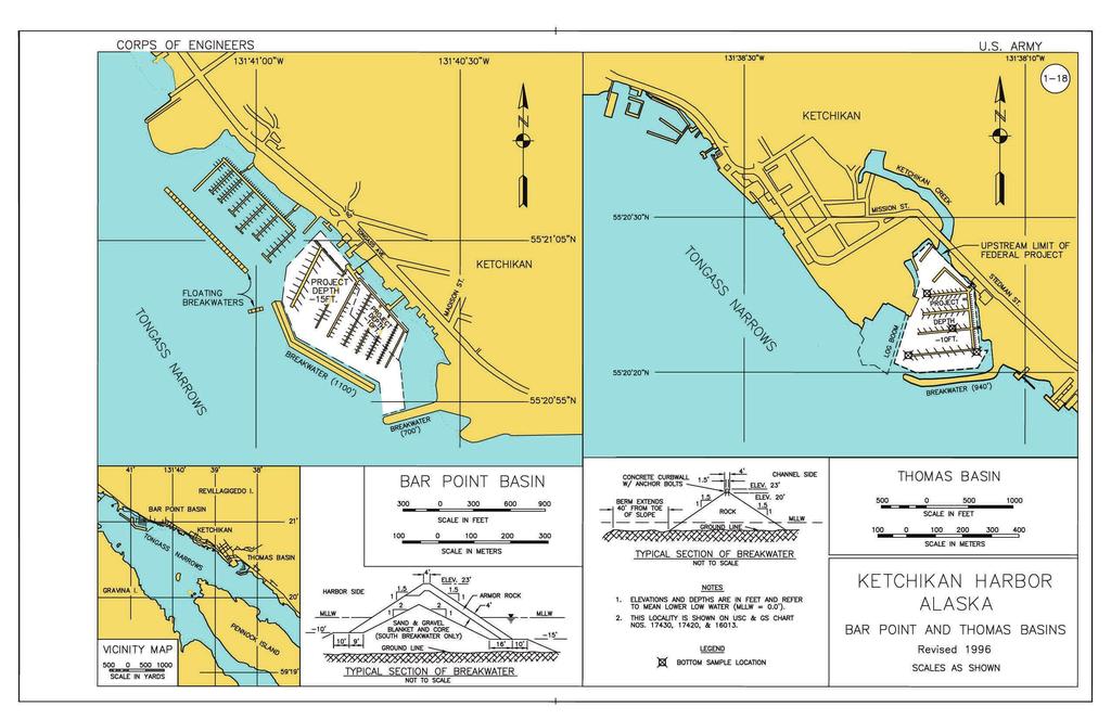
3 1-22 KETCHIKAN, ALASKA (Thomas and Bar Point Basins) (CWIS NOS & 87071) Condition of Improvement 30 September 2007 AUTHORIZATION: (1) Rivers and Harbors Act, 3 July 1930 (House Doc. 113, 70th Congress, 1st Session) as adopted, provides for construction of a stone breakwater with concrete cap, 940 feet in length, to protect the harbor in the vicinity of Ketchikan Creek, and dredging the protected area (11.35 acres) to a depth of -10 feet MLLW; (2) Rivers and Harbors Act, 2 September 1954 (House Doc. 501, 82nd Congress, 2nd Session) provides for the dredging of an additional small boat basin at Bar Point, acres in area, to depths of -10 and -15 feet MLLW, and construction of three rock breakwaters 700, 1,100 and 450 feet in length, topped by concrete gravity walls. EXISTING PROJECT: LENGTH DEPTH WIDTH Thomas Basin acres -10 ft N/A Breakwater (Thomas Basin) ft Bar Point Basin acres -10,-15 ft N/A Southeast Breakwater ft West Breakwater ft Floating Breakwater ft Floating Breakwater ft PROJECT USAGE: Thomas Basin and Bar Point Harbor are used as a base of operations for commercial fishing and are capable of accommodating 300 and 520 vessels respectively. In addition, the harbors are used by more than 100 transient fishing boats as a seasonal base of operations. PROGRESS OF WORK: The small boat basin at Ketchikan Creek, Thomas Basin, is completed Maintenance dredging in Thomas Basin is begun in June and finished in FY Construction of Bar Point Basin begins in November with work on the Southeast Breakwater. The concrete gravity walls have been deleted during design and compensated for by increased breakwater elevation Bar Point Basin is successfully completed in November Thomas Basin is dredged by contract over the summer Maintenance dredging in Thomas Basin begins in July and is completed in August with the removal of 24,316 cubic yards. A controlling depth of -14 feet MLLW is reported A contract for maintenance dredging in Thomas Basin is awarded in June and completed in October with 2,530 cubic yards of material removed Repair of the rock breakwater at Thomas Basin begins in October and is completed in November Under Section 107 of the River and Harbor Act, 14 July 1960, as approved on 29 June 1978, Bar Point Harbor expansion is authorized for the construction and placement of 2 concrete floating breakwaters of 963 and 120 feet to enclose a basin of about 25 acres. Continues on page 1-22a 1-22
4 1-22a KETCHIKAN, ALASKA (continued) 30 September Work begins on the Bar Point Harbor expansion in April. The 450 foot breakwater is subsequently de-authorized in November After repair of wind damage, the floating breakwaters are completed in place in April The latest condition survey of both harbors is performed in January and February. Sampling and testing is carried out for Thomas Basin. The U.S. Navy is hired under contract to inspect the floating breakwaters at Bar Point Harbor Maintenance dredging is completed at Thomas Basin in February with the removal of 8,678 cubic yards. The Navy is contracted to rehabilitate the floating breakwaters at Bar Point Condition surveys of both harbors are conducted with multi-beam techniques in April Anchor blocks for the floating breakwaters at Bar Point Harbor are located by survey Condition surveys of Thomas Basin and Bar Point Harbor are conducted in July Aerial photography is taken of both harbors in April The most recent condition surveys of Thomas Basin and Bar Harbor South are conducted in May The floating breakwaters at Bar Point Harbor were inspected by the U.S. Army dive team Repair to the floating breakwater by the Army dive team includes realignment/replacing the wire tension ropes, replaced missing and badly corroded anchor chains, repositioned anchor blocks, adjusted slack in anchor chains, replaced wooden fender system, and repaired concrete damage. COST TO DATE: New Work Maintenance Total United States Funds $ 4,792,227 $1,499,150 $ 6,291,377 Contributed Funds $ 2,345, $ 2,345,718 Total Costs $ 7,137,945 $1,499,150 $ 8,637,095 RANGE OF TIDE: Mean Range Diurnal Range Extreme Range 12.9' 15.3' 26.0' CONTROLLING DEPTH: Bar Point Harbor: A depth of feet MLLW controls in the 15 foot maneuvering area; for the 10 foot area some minor shoaling is present along the northern limit but should not impact local traffic. Thomas Basin: A depth of 8.1 feet MLLW controls for the transient float in the northern area near Ketchikan Creek, otherwise project depth is effectively available throughout most of the basin, May a


5 KETCHIKAN THOMAS AND BAR POINT HARBORS, KETCHIKAN, ALASKA
Ketchikan Harbors Thomas Basin and Bar Point Harbor
 Ketchikan Harbors Thomas Basin and Bar Point Harbor Condition of Improvements 30 December 2014 Thomas Basin & Bar Point Harbors Ketchikan, Alaska (CWIS No. 000631 & 087071) Authorization (1) Rivers and
1-44. SITKA HARBOR, ALASKA (Western Channel, Crescent Bay Basin, Channel Rock Breakwaters) (CWIS NOS , 16840, 10322, 55030, 13787)
 (CWIS NOS , 16840, 10322, 55030, 13787)") SITKA 1-44 SITKA HARBOR, ALASKA (Western Channel, Crescent Bay Basin, Channel Rock Breakwaters) (CWIS NOS. 72845, 16840, 10322, 55030, 13787) Condition of Improvement 30 September 2011 AUTHORIZATION:
SITKA 1-44 SITKA HARBOR, ALASKA (Western Channel, Crescent Bay Basin, Channel Rock Breakwaters) (CWIS NOS. 72845, 16840, 10322, 55030, 13787) Condition of Improvement 30 September 2011 AUTHORIZATION:
Condition of Improvements 30 December 2014 Wrangell Harbors, Alaska (CWIS No , )
") Wrangell Harbors Condition of Improvements 30 December 2014 Wrangell Harbors, Alaska (CWIS No. 010435, 021500) Authorization (1) Rivers and Harbors Act, 22 September 1922 (House Doc. 161, 67th Congress,
Wrangell Harbors Condition of Improvements 30 December 2014 Wrangell Harbors, Alaska (CWIS No. 010435, 021500) Authorization (1) Rivers and Harbors Act, 22 September 1922 (House Doc. 161, 67th Congress,
Juneau Aurora Harbor
 Juneau Aurora Harbor Aurora Harbor Page 2 of 6 Condition of Improvements 31 December 2017 Aurora Harbor Juneau, Alaska (CWIS No. 020960) Authorization Rivers and Harbors Act, 3 July 1958 (House Doc. 286,
Cordova Harbor Page 2 of 9
 Cordova Harbor Cordova Harbor Page 2 of 9 Condition of Improvements 30 December 2017 Cordova Harbor, Alaska (CWIS No. 087136, 087186, 087711) Authorization Rivers and Harbors Act, 30 August 1935 (R & H
Juneau Douglas Harbor
 Juneau Douglas Harbor Douglas Harbor Page 2 of 8 Condition of Improvements 31 December 2015 Douglas Harbor, Alaska (CWIS No. 072789, 180942) Authorization Rivers and Harbors Act, 3 July 1958 (House Doc.
1-32 NOME HARBOR, ALASKA (CWIS NOS , 87755, 12270, & 10422) Condition of Improvement 30 September 2012
 Condition of Improvement 30 September 2012") NOME HARBOR 1-32 NOME HARBOR, ALASKA (CWIS NOS. 72742, 87755, 12270, & 10422) Condition of Improvement 30 September 2012 AUTHORIZATION: (1) Rivers and Harbors Act, 8 August 1917 (House Doc. 1932, 64th
NOME HARBOR 1-32 NOME HARBOR, ALASKA (CWIS NOS. 72742, 87755, 12270, & 10422) Condition of Improvement 30 September 2012 AUTHORIZATION: (1) Rivers and Harbors Act, 8 August 1917 (House Doc. 1932, 64th
1-32 NOME HARBOR, ALASKA (CWIS NOS , 87755, & 10422) Condition of Improvement 30 September 2009
 Condition of Improvement 30 September 2009") NOME HARBOR 1-32 NOME HARBOR, ALASKA (CWIS NOS. 72742, 87755, & 10422) Condition of Improvement 30 September 2009 AUTHORIZATION: (1) Rivers and Harbors Act, 8 August 1917 (House Doc. 1932, 64th Congress,
NOME HARBOR 1-32 NOME HARBOR, ALASKA (CWIS NOS. 72742, 87755, & 10422) Condition of Improvement 30 September 2009 AUTHORIZATION: (1) Rivers and Harbors Act, 8 August 1917 (House Doc. 1932, 64th Congress,
Nome Harbor Page 2 of 12
 Nome Harbor Nome Harbor Page 2 of 12 Condition of Improvements 30 December 2015 Nome Harbor, Alaska (CWIS No. 010422, 012270, 072742, 087755) Authorization (1) Rivers and Harbors Act, 8 August 1917 (House
Ninilchik Harbor Page 2 of 11
 Ninilchik Harbor Ninilchik Harbor Page 2 of 11 Condition of Improvements 31 December 2017 Ninilchik Harbor, Alaska (CWIS No. 012640, 087345) Authorization Rivers and Harbors Act, 3 July 1958 (P.L. 85-500
CORPS FACTS. Harbor Dredging U.S. ARMY CORPS OF ENGINEERS BUILDING STRONG
 CORPS FACTS Harbor Dredging U.S. ARMY CORPS OF ENGINEERS BUILDING STRONG Disaster Response Sedimentation in the channel is caused by the normal cycle of silt movement, erosion from high water or heavy
Grays Harbor O&M and Deepening Dredging
 Grays Harbor O&M and Deepening Dredging Elizabeth Chien Project Manager Seattle District 28 January 2016 US Army Corps of Engineers Grays Harbor Navigation Channel Inner Harbor O&M Dredging Summer 2015:
Mouth of the Columbia River Jetties Three-Phase Construction Plan
 Mouth of the Columbia River Jetties Three-Phase Construction Plan Project Overview October 9, 2012 US Army Corps of Engineers MCR Jetties Major Rehabilitation Sand Island pile dikes 1930-1935 Columbia
Grays Harbor Federal Project
 Grays Harbor Federal Project Elizabeth Chien Coastal Navigation Program Manager Seattle District 27 October 2016 US Army Corps of Engineers Grays Harbor Navigation Channel Inner Harbor Dredging Summer
UNITED NEW YORK SANDY HOOK PILOTS BENEVOLENT ASSOCIATION AND UNITED NEW JERSEY SANDY HOOK PILOTS BENEVOLENT ASSOCIATION
 UNITED NEW YORK SANDY HOOK PILOTS BENEVOLENT ASSOCIATION AND UNITED NEW JERSEY SANDY HOOK PILOTS BENEVOLENT ASSOCIATION TO: All Shipping Agents and Interested Parties January 19, 2017 SUBJECT: Anchorage
V. HARBOR DEPTHS, CHANNEL DESIGN AND PROPOSED CONSTRUCTION AND DREDGING
 V. HARBOR DEPTHS, CHANNEL DESIGN AND PROPOSED CONSTRUCTION AND DREDGING A. DISCUSSION: For the most part, projects that involve dredging and construction require a comprehensive design and review process
HARBOR INFRASTRUCTURE INVENTORIES Oak Orchard Harbor, New York
 HARBOR INFRASTRUCTURE INVENTORIES Oak Orchard Harbor, New York Harbor Location: Oak Orchard Harbor is located on the southern shore of Lake Ontario at the mouth of Oak Orchard Creek in the village of Point
Pacific Ocean Division. Navigation Program Overview. Association of Pacific Ports 2016 Winter Conference Waikaloa, Hawaii.
 Pacific Ocean Division Navigation Program Overview Association of Pacific Ports 2016 Winter Conference Waikaloa, Hawaii David Lau Pacific Ocean Division Chief, Civil Works Integration Division January
HARBOR INFRASTRUCTURE INVENTORIES West Harbor, OH
 HARBOR INFRASTRUCTURE INVENTORIES West Harbor, OH Harbor Location: West Harbor is located on the southern shore of Lake Erie in the township of Catawba Island, OH about 50 miles east of Toledo, OH. Authority:
Redondo Beach Boat Launch Ramp Facility
 Redondo Beach Boat Launch Ramp Facility Feasibility Report for the California Department of Boating and Waterways 2015 Grant Cycle For the City of Redondo Beach Submitted by March 13, 2014 Table of Contents
Information for File # SEW
 Information for File #2014-02744-SEW Applicant: Minnesota Department of Transportation (MnDOT), District 3; c/o Mr. Robert Nibbe Corps Contact: Sarah Wingert, U.S. Army Corps of Engineers, 180 5 th Street
New Orleans Municipal Yacht Harbor
 New Orleans Municipal Yacht Harbor Marina Schematic Design Update 601 Poydras St., Suite 1860 New Orleans, LA, 70130 504-648-3560 Post-Katrina Municipal Yacht Harbor: Introduction The MYH was an approximate
ROOK COMPANY PANAMA CANAL BANCROFT LIBRARY
 F 1563 ROOK COMPANY PANAMA CANAL BANCROFT LIBRARY University of California Berkeley TTTe PANAMA CANAL I The Land Divided Fin The World Unvted ' A Pidtorial Review of its Construction together with
Description of Underwater Noise Attenuation System Design Unit 2. New NY Bridge Project
 New NY Bridge Project Description of Underwater Noise Attenuation System (NAS) Design Unit 2 Description of Underwater Noise Attenuation System Design Unit 2 for the New NY Bridge Project Revision 1 May
Project Incorporation of Sea Level Rise City of Newport Beach Approach for Balboa Islands, City of Newport Beach, California
 Project Incorporation of Sea Level Rise City of Newport Beach Approach for Balboa Islands, City of Newport Beach, California Ying Poon, Everest International Consultants, Inc. CMANC Annual Winter Meeting
PNWA Conference Update
 PNWA Conference Update COLONEL Jose Aguilar District Commander Portland District 2 October, 2014 US Army Corps of Engineers Projects Mouth of the Columbia (MCR) Jetties Columbia River Status Coastal Dredging
APPENDIX D REAL ESTATE PLAN
 NAVIGATION IMPROVEMENTS SITKA HARBOR, ALASKA CHANNEL ROCK BREAKWATERS DRAFT DEFICIENCY CORRECTION EVALUATION REPORT APPENDIX D REAL ESTATE PLAN JANUARY 2011 REAL ESTATE PLAN FOR SITKA HARBOR, ALASKA CHANNEL
DRAFT. October 17, 2014 File No Mr. Brendhan Zubricki Town Administrator Essex Town Hall 30 Martin Street Essex, MA.
 GZA GeoEnvironmental, Inc. Engineers and Scientists October 17, 2014 File No. 18.0171857.00 Mr. Brendhan Zubricki Town Administrator Essex Town Hall 30 Martin Street Essex, MA. 01929 DRAFT Re: Essex River
Coastal Harbors and Waterways, NC (Shallow Draft Navigation) (O&M)
 (O&M)") Coastal Harbors and Waterways, NC (Shallow Draft Navigation) (O&M) Shallow draft coastal harbors include a subsistence harbor at Silver Lake CONGRESSIONAL DISTRICT: NC 3, 7 DATE: 23 April 2018 1. AUTHORIZATION:
Coastal Harbors and Waterways, NC (Shallow Draft Navigation) (O&M) Shallow draft coastal harbors include a subsistence harbor at Silver Lake CONGRESSIONAL DISTRICT: NC 3, 7 DATE: 23 April 2018 1. AUTHORIZATION:
La Quinta Channel Extension Port of Corpus Christi Ingleside, Texas. Mark Coyle
 La Quinta Channel Extension Port of Corpus Christi Ingleside, Texas Mark Coyle Corpus Christi Navigation Channel PCCA La Quinta Expansion Project History Corpus Christi Ship Channel Improvement Projects
HARBOR INFRASTRUCTURE INVENTORIES Port Sanilac Harbor, Michigan
 HARBOR INFRASTRUCTURE INVENTORIES Port Sanilac Harbor, Michigan Harbor Location: Port Sanilac Harbor is located on the west shore of Lake Huron, about 30 miles north of Port Huron, MI. Authority: Rivers
Wexford Harbour. Yachting Guide. Navigation
 Wexford Harbour Yachting Guide Navigation This document supersedes all previous editions. Approvals: Yacht Club Committee April, 2015 Wexford Board of Directors April, 2015 # Date Section Revision 1 6.5.2015
DEPARTMENT OF THE ARMY GALVESTON DISTRICT, CORPS OF ENGINEERS P.O. BOX 1229 GALVESTON, TEXAS CESWG-CDR (1145)
") DEPARTMENT OF THE ARMY GALVESTON DISTRICT, CORPS OF ENGINEERS P.O. BOX 1229 GALVESTON, TEXAS 77553-1229 REPLY TO ATTENTION OF CESWG-CDR (1145) TBD MEMORANDUM FOR All Galveston District Personnel. SUBJECT:
DEPARTMENT OF THE ARMY GALVESTON DISTRICT, CORPS OF ENGINEERS P.O. BOX 1229 GALVESTON, TEXAS 77553-1229 REPLY TO ATTENTION OF CESWG-CDR (1145) TBD MEMORANDUM FOR All Galveston District Personnel. SUBJECT:
MILE POINT TRAINING WALL JACKSONVILLE, FL. Geotextile Tube Installation
 MILE POINT TRAINING WALL JACKSONVILLE, FL Geotextile Tube Installation PROJECT DESIGN Remove portion of existing training wall Construct new eastern and western training walls Deepen new flow improvement
Cline s Point Marina Ship Wave Analysis
 Cline s Point Marina Ship Wave Analysis Draft Technical Report April 13, 2015 Submitted To: Port of Corpus Christi Authority Prepared for: Port of Corpus Christi Authority This document is intended for
ST. JOSEPH PENINSULA, GULF COUNTY, FLORIDA Beach Re-Nourishment and Environmental Enhancement Project RECOMMENDATIONS
 ST. JOSEPH PENINSULA, GULF COUNTY, FLORIDA Beach Re-Nourishment and Environmental Enhancement Project RECOMMENDATIONS January 23, 2018 543 Harbor Boulevard, Suite 204 Destin, Florida 32541 850.654.1555
SPECIAL SPRING 2018 STORM REPORT ON THE CONDITION OF THE MUNICIPAL BEACHES FOR THE BOROUGH OF STONE HARBOR, CAPE MAY COUNTY, NEW JERSEY
 SPECIAL SPRING 2018 STORM REPORT ON THE CONDITION OF THE MUNICIPAL BEACHES FOR THE BOROUGH OF STONE HARBOR, CAPE MAY COUNTY, NEW JERSEY Aerial photograph taken April 21, 2018 showing the view up the beach
Hydrographic Surveying Methods, Applications and Uses
 Definition: Hydrographic Surveying Methods, Applications and Uses It is the branch of surveying which deals with any body of still or running water such as a lake, harbor, stream or river. Hydrographic
ST. LOUIS SECTION PROJECT OF THE YEAR AWARD
 ST. LOUIS SECTION PROJECT OF THE YEAR AWARD Originality and Innovation The St. Louis Harbor Project is located in the Upper Mississippi River between the entrance to the Chain of Rocks Canal at River
MAC Transit Advisories as of April 30, 2018
 MAC Transit Advisories as of April 30, 2018 The Mariners Advisory Committee for the Bay and River Delaware was established in October 1964. Its members and associate members are mainly comprised of master
Eelgrass Survey Reporting Form 2222 Channel Road Newport Beach, CA Eelgrass (Zostera marina) Survey
 Survey") Eelgrass Survey Reporting Form 2222 Channel Road Newport Beach, CA 92660 Eelgrass (Zostera marina) Survey Survey Date: July 19th, 2013 Report Date: July 26 th, 2013 Prepared by: Coastal Resources Management,
Eelgrass Survey Reporting Form 2222 Channel Road Newport Beach, CA 92660 Eelgrass (Zostera marina) Survey Survey Date: July 19th, 2013 Report Date: July 26 th, 2013 Prepared by: Coastal Resources Management,
Coastal Engineering Technical Note
 Coastal Engineering Technical Note BAFFLED BREAKWATER FOR LIMITED FETCH SITES CETN III-45.(12/91) PURPOSE: To describe the Spud Point Marina breakwater, an innovative baffledtype breakwater designed to
Coastal Harbors and Waterways, NC (Shallow Draft Navigation) (O&M)
 (O&M)") Coastal Harbors and Waterways, NC (Shallow Draft Navigation) (O&M) Shallow draft coastal harbors include a subsistence harbor at Silver Lake CONGRESSIONAL DISTRICT: NC 3 and 7 DATE: 23 February 2015 1.
Coastal Harbors and Waterways, NC (Shallow Draft Navigation) (O&M) Shallow draft coastal harbors include a subsistence harbor at Silver Lake CONGRESSIONAL DISTRICT: NC 3 and 7 DATE: 23 February 2015 1.
MOREHEAD CITY HARBOR, NC. Dredged Material Management Plan (DMMP)
") MOREHEAD CITY HARBOR, NC Dredged Material Management Plan (DMMP) Public Meeting/Info Session 15 January 2014 US Army Corps of Engineers Morehead City Harbor DMMP Presentation Topics Morehead City Harbor
MOREHEAD CITY HARBOR, NC Dredged Material Management Plan (DMMP) Public Meeting/Info Session 15 January 2014 US Army Corps of Engineers Morehead City Harbor DMMP Presentation Topics Morehead City Harbor
SECTION I NM 5/17 CHART CORRECTIONS
 CHART CORRECTIONS 1116A 79Ed. 2/16 LAST NM 4/17 5/17 Delete Platform 28 22.9 N 90 32.1 W 11301 26Ed. 11/13 LAST NM 47/16 5/17 Delete Light 7 26 03 14 N 97 12 40 W 11302 34Ed. 1/14 LAST NM 15/16 5/17 (Side
2018 Beach Preservation Project Information
 QUICK FACTS Beach Renourishment to begin late April 2018 o U.S. Army Corps of Engineers project o Project Area: 8 th St. E. to end of E. Ashley Ave. o Project Length: 2 miles o Cost: $10,900,000 o Funding:
Port Sections Guide Section 01
 s Guide 01 Cow Bay Marina Date 10/1/2016 Position (lat / lon) Minimum controlled water depth Chart datum Range of water densities Tidal range alongside Bottom type Dredging regime Distance pilot station
UMass Boston Waterfront at a glance
 UMass Boston Waterfront at a glance Fox Point Pavilion Over the years, the Fox Point Landing has been a rest area, an outdoor classroom and a general meeting place for students, staff and faculty of the
Coastal Harbors and Waterways, NC (Shallow Draft Navigation) (O&M)
 (O&M)") Coastal Harbors and Waterways, NC (Shallow Draft Navigation) (O&M) Shallow draft coastal harbors include a subsistence harbor at Silver Lake CONGRESSIONAL DISTRICT: NC 3 and 7 DATE: 23 February 2015 1.
Coastal Harbors and Waterways, NC (Shallow Draft Navigation) (O&M) Shallow draft coastal harbors include a subsistence harbor at Silver Lake CONGRESSIONAL DISTRICT: NC 3 and 7 DATE: 23 February 2015 1.
Transfer Chain (SA-1002) & Adjustable I-Beam Clamp (SA-1039 or SA-1040) Operating Instructions
 & Adjustable I-Beam Clamp (SA-1039 or SA-1040) Operating Instructions") Transfer Chain (SA-1002) & Adjustable I-Beam Clamp (SA-1039 or SA-1040) Operating Instructions SPIDER Page 1 of 8 702127 Rev A Using Transfer Chain with Adjustable I-Beam Clamp Safety Notes Do not use
Transfer Chain (SA-1002) & Adjustable I-Beam Clamp (SA-1039 or SA-1040) Operating Instructions SPIDER Page 1 of 8 702127 Rev A Using Transfer Chain with Adjustable I-Beam Clamp Safety Notes Do not use
HARBOR INFRASTRUCTURE INVENTORIES Lorain Harbor, Ohio
 HARBOR INFRASTRUCTURE INVENTORIES Lorain Harbor, Ohio Harbor Location: Lorain Harbor is located on the southern shore of Lake Erie in the city of Lorain, OH about 45 miles west of Cleveland, OH. Authority:
Structural Assessment. USS Yorktown CV-10
 Structural Assessment of USS Yorktown CV-10 Assessment Team USS Yorktown History Constructed December 1941- January 1943 Essex Class CV-10 10 th USS Navy Aircraft Carrier Served in WWII Modified in 1955
RE: Hurricane Matthew Beach Damage Assessment and Recommendations [CSE 2416]
![RE: Hurricane Matthew Beach Damage Assessment and Recommendations [CSE 2416]](/thumbs/83/87675702.jpg "RE: Hurricane Matthew Beach Damage Assessment and Recommendations [CSE 2416]") October 25, 2016 Iris Hill Town Administrator Town of Edisto Beach 2414 Murray St Edisto Beach SC 29438 RE: Hurricane Matthew Beach Damage Assessment and Recommendations [CSE 2416] Dear Iris, Hurricane
October 25, 2016 Iris Hill Town Administrator Town of Edisto Beach 2414 Murray St Edisto Beach SC 29438 RE: Hurricane Matthew Beach Damage Assessment and Recommendations [CSE 2416] Dear Iris, Hurricane
Upper/Lower Owl Creek Reservoir
 Upper/Lower Owl Creek Reservoir Schuylkill County 2018 Largemouth Bass Survey Upper Owl Creek Reservoir and Lower Owl Creek Reservoir are 67-acre and 26-acre impoundments, respectively, created by two
APPENDIX D-2. Sea Level Rise Technical Memo
 APPENDIX D-2 Sea Level Rise Technical Memo 2185 N. California Blvd., Suite 500 Walnut Creek, CA 94596 (925) 944-5411 Fax: (925) 944-4732 www.moffattnichol.com DRAFT MEMORANDUM To: From: Neil Nichols,
HARBOR INFRASTRUCTURE INVENTORIES Marquette Harbor, Michigan
 HARBOR INFRASTRUCTURE INVENTORIES Marquette Harbor, Michigan Harbor Location: Marquette Harbor is located in Marquette Bay on the south shore of Lake Superior, 160 miles west of Sault Ste. Marie, MI and
Southeast Sustainable Salmon Fund Project Statement of Work
 Southeast Sustainable Salmon Fund Project Statement of Work I. Project Title: Gastineau Channel/Sheep Creek Net Pen Complex II. Project Manager/Principal Investigator: Eric Prestegard Director of Operations
Dive Operations Plan for Personal Submersibles. Revision
 Dive Operations Plan for Personal Submersibles Revision 2011.1 1 Table of Contents 1 EVENT...3 1.1 Summary of planned dive...3 1.1.1 PSUBS Guidelines...3 1.1.2 Maximum dive depth planned...3 1.1.3 Number
MOORING INFORMATION FOR BOAT OWNERS AT RGYC
 MOORING INFORMATION FOR BOAT OWNERS AT RGYC Boat owners with vessels stored in the RGYC Marina are encouraged to review the way their vessel is moored in its pen. Insurance All vessel owners must have
2.2. Anchorage Point A secure point of attachment for Lifelines, lanyards or deceleration devices.
 Title: Elevated Walking/Working Surfaces (Fall Protection) Site Function: Safety Procedure No.: MC032.122 Page: 1 of 16 McIntosh Site Reviewed: 02/2013 Effective: 03/2013 Supersedes: 08/2012 Preparer:
Forth Ports Limited. Ruling Depths & Under Keel Clearances
 Forth Ports Limited - Forth Vessels are scheduled into / out of ports on the Forth & Tay in accordance with the under keel clearance criteria specified in this section of the Marine Guidelines & Port Information.
Assateague Island National Seashore North End Restoration Project Timeline
 Assateague Island National Seashore North End Restoration Project Timeline Date Event Some information provided in the Project Introduction document. Detailed events are available in a timeline compiled
REVISED SILT CURTAIN DEPLOYMENT PLAN
 Contract No.: HY/2009/11 Central Wanchai Bypass, North Point Reclamation REVISED SILT CURTAIN DEPLOYMENT PLAN Name Prepared by: China Harbour Engineering Co., Ltd. China Road and Bridge Corporation Joint
Bear Cove Coastline Reestablishment
 Coastal and Ocean Engineering Undergraduate Student Forum, COASTAL-2013 Faculty of Engineering and Applied Science, Memorial University, St. john s, NL, Canada March, 2013 Bear Cove Coastline Reestablishment
CCR Landfill 2017 Annual Inspection Report NC1 Ash Disposal Area
 CCR Landfill 2017 Annual Inspection Report NC1 Ash Disposal Area Omaha Public Power District Nebraska City Station Nebraska City, Nebraska January 19, 2018 OPPD Nebraska City Station NC1 Ash Disposal Area
Reviewed: New Effective: 5/18/12 Supersedes: New Preparer: Owner: Approver: Team Member, Occupational Safety Industrial Hygiene
 Procedure No.: BC032.027 Page: 1 of 15 Preparer: Owner: Approver: Team Member, Occupational Safety Industrial Hygiene Manager, Occupational Safety Industrial Hygiene Vice President, Ecology & Safety (Signature
2016 Annual Inspection Report
 2016 Annual Inspection Report for Compliance with the Coal Combustion Residuals Rule (40 CFR Part 257) Pawnee Station 14940 Morgan County Road 24 Brush, Colorado 80723 January 18, 2017 Table of Contents
Rising Tide Oyster Company 2.0 Acre Bellamy Site Marine Aquaculture License Application
 Rising Tide Oyster Company 2.0 Acre Bellamy Site Marine Aquaculture License Application Joshua and Jessica Carloni 264 Swain Road Barrington, N.H. 03825 Summary This is an amendment to our existing license
JUNEAU SECOND CHANNEL CROSSING WATERWAY USER SURVEY RESULTS
 JUNEAU SECOND CHANNEL CROSSING WATERWAY USER SURVEY RESULTS PREPARED FOR: HDR Alaska, Inc. PREPARED BY: Juneau Anchorage December 2003 TABLE OF CONTENTS Executive Summary...1 Introduction and Methodology...2
HARBOR INFRASTRUCTURE INVENTORIES Fairport Harbor, OH
 HARBOR INFRASTRUCTURE INVENTORIES Fairport Harbor, OH Harbor Location: Fairport Harbor is located at the mouth of the Grand River on the southern shore of Lake Erie in the city of Fairport, OH, approximately
PROPOSAL. PROPOSAL OF, a corporation a
 PROPOSAL PROPOSAL OF, a corporation a partnership consisting of and an individual doing business as TO THE SAN ANTONIO WATER SYSTEM: Pursuant to Instruction and Invitations to Bidders, the undersigned
Cat Island Chain Restoration
 Cat Island Chain Restoration 1820s Fox River Military Road Map to Fort Howard 1845 Chart of Green Bay & Fox River Cat Island Chain - 1938 Cat Island Brown County Aerial Photography, 1938 Historic Western
PEASE DEVELOPMENT AUTHORITY DIVISION OF PORTS & HARBORS ANNUAL DREDGE REPORT
 PEASE DEVELOPMENT AUTHORITY DIVISION OF PORTS & HARBORS ANNUAL DREDGE REPORT 2018 555 Market Street Portsmouth, New Hampshire 03801 Phone #603 436 8500 Fax #603 436 2780 TABLE OF CONTENTS Cover Page Table
POP UP ANCHOR. Part Number Spectrum Lane ~ Missoula MT ~
 POP UP ANCHOR Part Number 153169 7100 Spectrum Lane ~ Missoula MT 59808 800.791.8056 ~ www.spectrumproducts.com You have purchased a Spectrum Products Pop Up Lane Rope Anchor. Providing the unit is installed
Inflatable Pontoons Listing ID:
 Australia - Great Britain - Indonesia - New Zealand - Philippines - Thailand - USA E: sales@seaboats.net (sales) - E: admin@seaboats.net (accounts) Inflatable Pontoons Listing ID: 427303 DESCRIPTION: AiroDock
Figure 262. Location map for the 10 NJBPN profile sites in Atlantic County, NJ 279
 278 Figure 262. Location map for the 10 NJBPN profile sites in Atlantic County, NJ 279 ATLANTIC COUNTY SUMMARY The Atlantic County coastline consists of three barrier islands. The island of Little Beach
SECTION II NM 11/13 NAVIGATION PUBLICATIONS COAST PILOT CORRECTIONS. Chapter 4 Paragraphs 85 to 86; read: (85)
") NAVIGATION PUBLICATIONS COAST PILOT CORRECTIONS COAST PILOT 1 42 Ed 2012 Change No. 13 LAST NM 9/13 Chapter 4 Paragraph 9; read: (9) Round Rock, which uncovers, and The Boring Stone, 3 feet high and bare,
NAVIGATION PUBLICATIONS COAST PILOT CORRECTIONS COAST PILOT 1 42 Ed 2012 Change No. 13 LAST NM 9/13 Chapter 4 Paragraph 9; read: (9) Round Rock, which uncovers, and The Boring Stone, 3 feet high and bare,
BANKSMAN / SLINGER. 1. What is the smallest size diameter of synthetic rope allowed for use as a hand held tagline?
 BANKSMAN / SLINGER 1. What is the smallest size diameter of synthetic rope allowed for use as a hand held tagline? A. 16mm B. 10mm C. 12mm 2. What is the maximum temperature that a webbing sling can be
Port Infrastructure to Support Floating Offshore Wind West Coast USA
 Port Infrastructure to Support Floating Offshore Wind West Coast USA Focus on California Figure: Principle Power Aaron Porter, P.E., & Shane Phillips, P.E. Mott MacDonald Seattle, WA BOEM Project Manager:
Designing a Harbor Entrance to Defeat Swell Wave Agitation. FAX (506) ; 2
 ; 2") Designing a Harbor Entrance to Defeat Swell Wave Agitation Mauricio Wesson, MSc. PE 1 and Jack C. Cox, PE, DPE, DCE, DNE 2 1 Watermark, La Sabana, San Jose, Costa Rica; PH (506) 2220-1198; FAX (506) 2290
Designing a Harbor Entrance to Defeat Swell Wave Agitation Mauricio Wesson, MSc. PE 1 and Jack C. Cox, PE, DPE, DCE, DNE 2 1 Watermark, La Sabana, San Jose, Costa Rica; PH (506) 2220-1198; FAX (506) 2290
SITE DEVELOPMENT PLAN FOR PLANTATION LANDING TOWNHOMES WILMINGTON, NORTH CAROLINA
 yard Sagewood Dr. 25' Setback 20' Future Greenway Esmt. SITE DEVELOPMENT PLAN FOR WILMINGTON, NORTH CAROLINA JUNE 2018 SITE DATA TABLE VICINITY MAP INDEX OF SHEETS LEGEND DEVELOPER/OWNER MUNGO HOMES OF
THE SYLLABUS FOR WRITTEN EXAMINATION PILOT'S FOURTH CLASS LICENCE (TEES AND HARTLEPOOL) AND
 AND") PD TEESPORT CONSERVANCY DIVISION HARBOUR MASTER'S OFFICE THE SYLLABUS FOR WRITTEN EXAMINATION IN RESPECT OF A PILOT'S FOURTH CLASS LICENCE (TEES AND HARTLEPOOL) AND PILOTAGE EXEMPTION CERTIFICATE (Issued
PD TEESPORT CONSERVANCY DIVISION HARBOUR MASTER'S OFFICE THE SYLLABUS FOR WRITTEN EXAMINATION IN RESPECT OF A PILOT'S FOURTH CLASS LICENCE (TEES AND HARTLEPOOL) AND PILOTAGE EXEMPTION CERTIFICATE (Issued
Eelgrass and Macroalgae Presence/Absence Preliminary Surveys BHP Proposed Grays Harbor Potash Export Facility A Task 400
 Memorandum 40600-HS-MEM-55036 Revision 0 Date: 26 July 2018 Subject: Eelgrass and Macroalgae Presence/Absence Preliminary Surveys BHP Proposed Grays Harbor Potash Export Facility A17.0202.00 Task 400 INTRODUCTION
23- Year Sand Volume Changes at Site 132, 15th Street, Brigantine
 149 Figure75. Location map for the 9 NJBPN profile sites in Atlantic County, NJ ATLANTIC COUNTY SPRING 2008 to FALL 2009 150 The Atlantic County oceanfront shoreline consists of three barrier islands.
Figure79. Location map for the 10 NJBPN profile sites in Atlantic County, NJ 155
 154 Figure79. Location map for the 10 NJBPN profile sites in Atlantic County, NJ 155 ATLANTIC COUNTY SPRING 2009 to FALL 2010 The Atlantic County coastline consists of three barrier islands. Between Little
FINDING OF NO SIGNIFICANT IMPACT
 DEPARTMENT OF THE ARMY CHARLESTON DISTRICT, CORPS OF ENGINEERS 69A HAGOOD AVENUE CHARLESTON, SOUTH CAROLINA 29403-5107 FINDING OF NO SIGNIFICANT IMPACT EDISTO BEACH COASTAL STORM DAMAGE REDUCTION GENERAL
St. George Harbor Feasibility Study. Appendix A - Hydraulic Design. St. George, Alaska. Tentatively Selected Plan August 17, 2018
 St. George Harbor Feasibility Study Appendix A - Hydraulic Design St. George, Alaska Tentatively Selected Plan August 17, 2018 U.S. Army Corps of Engineers Alaska District CONTENTS 1. INTRODUCTION... 1
30 DAY PUBLIC NOTICE MAINTENANCE DREDGING OF THE 8-FOOT CHANNEL OF THE FEDERAL NAVIGATION PROJECT IN KENNEBUNK RIVER KENNEBUNK & KENNEBUNKPORT, ME
 fr.iiif.i ~ US Anny Corps of Engineers New England District 696 Virginia Road Concord, MA 01742-2751 Public Notice In Reply Refer to: Mr. Jack Karalius nae-pn-nav@usace.army.mil Programs/Project Management
ADC PROGRAM - MARITIME EMPLOYER S LIABILITY APPLICATION FORM (FEBRUARY 2007)
") ADC PROGRAM - MARITIME EMPLOYER S LIABILITY APPLICATION FORM (FEBRUARY 2007) 1) A. Full name and address of Assured: B. How many years has Assured been in operation: 2) Full details of Assured s overwater
ADC PROGRAM - MARITIME EMPLOYER S LIABILITY APPLICATION FORM (FEBRUARY 2007) 1) A. Full name and address of Assured: B. How many years has Assured been in operation: 2) Full details of Assured s overwater
Township of North Huntingdon Application for Permit
 Township of North Huntingdon Application for Permit 11279 Center Highway, North Huntingdon, PA 15642 724-863-3806 ext. 126 / www.nhtpa.us 1. Swimming Pool Permit Request TYPE OF STRUCTURE: SWIMMING POOL
Installation, Operating, Inspection and Maintenance Instructions Ladder Climber s Safety System. Warning
 OWNER'S MANUAL Installation, Operating, Inspection and Maintenance Instructions Ladder Climber s Safety System Model # s: 6000, 6001, 6010 Warning You must read and fully understand all instructions, or
R. Randall Center for Dredging Studies Texas A&M University
 R. Randall Center for Dredging Studies Texas A&M University i Glory (Caisson) holes for subsea installations Pipeline trenches Deep ocean mining LNG ports & ship channels Summary WEDA 33 & TAMU 44 2 WEDA
NOBLE REV 02 FPSO MOORING SYSTEM INTEGRITY STUDY
 DENTON INTEGRITY STUDY APPENDIX C INCIDENT REPORTS Incident One FPSO Questionnaire Failure of gripper used to rotate turret Several months after installation This FPSO has an internal partially rotating
FINDLAY TOWNSHIP BUILDING INSPECTION DEPT
 Page 1 of 7 FINDLAY TOWNSHIP BUILDING INSPECTION DEPT. RESIDENTIAL SWIMMING POOLS Permit application submittal requirements (As per the 2009 International Residential Code) NOTE: A building permit is required
Delaware River Vessel Reporting System Mariners Advisory Committee For
 Delaware River Vessel Reporting System Mariners Advisory Committee For the Bay and River Delaware The Mariner's Advisory Committee is comprised of Master Mariners, River Pilots, and concerns itself with
Swimming Pools, Spas & Hot Tubs Construction requirements for outdoor private swimming pools (in-ground and above-ground), spas and hot tubs
, spas and hot tubs") PLANNING, PROPERTY AND DEVELOPMENT DEPARTMENT Swimming Pools, Spas & Hot Tubs Construction requirements for outdoor private swimming pools (in-ground and above-ground), spas and hot tubs November December
PLANNING, PROPERTY AND DEVELOPMENT DEPARTMENT Swimming Pools, Spas & Hot Tubs Construction requirements for outdoor private swimming pools (in-ground and above-ground), spas and hot tubs November December
On the occasion of the Athens 2004 Olympic Games event presented
 On the occasion of the Athens 2004 Olympic Games event presented herebelow are certain structures for which ATHENA S.A. is very proud for the timely completion and quality achieved. ATHENA S.A. participated
BookletChart. Chesapeake Bay Severn and Magothy Rivers NOAA Chart A reduced-scale NOAA nautical chart for small boaters
 BookletChart Chesapeake Bay Severn and Magothy Rivers NOAA Chart 12282 A reduced-scale NOAA nautical chart for small boaters When possible, use the full-size NOAA chart for navigation. Published by the
City of Port Aransas Shoreline Analysis and Improvements
 City of Port Aransas Shoreline Analysis and Improvements FINAL Technical Report August 24, 2016 Submitted To: City of Port Aransas Prepared for: City of Port Aransas This document is intended for planning
SACO RIVER AND CAMP ELLIS BEACH SACO, MAINE SECTION 111 SHORE DAMAGE MITIGATION PROJECT APPENDIX F ECONOMIC ASSESSMENT
 SACO RIVER AND CAMP ELLIS BEACH SACO, MAINE SECTION 111 SHORE DAMAGE MITIGATION PROJECT APPENDIX F ECONOMIC ASSESSMENT Department of the Army New England District, Corps of Engineers 696 Virginia Road