Overview of Metal Detecting Saltwater Beaches
|
|
|
- Rafe Hancock
- 6 years ago
- Views:
Transcription


1 MDHTALK The Ideal Beach Overview of Saltwater by Lee Wiese May 04, 2011 MDHTALK.org 1

2 Beach Profile Old Beach Portion Dry Sand New Beach Portion this is Sand that is Re-deposited in the Spring At Low Tide this Portion of the Beach is Exposed Swell Period This Portion of the Beach is Usually Removed in Winter Storms Beach Slope is Mix of Dry & Wet Sand To Become a Serious Beach Hunter and have Consisted Results You Must Learn to READ the Beach 2
3 Profile 3
4 Saltwater are Ever Changing The Beach Shore Profile can be Different from Day-to-Day and can Change Dramatically from Season-to-Season. The Causes for Beach Change or Erosion are: High and / or Low Tides High Surf / Swell Conditions (5-20 ft) Short or Long Swell Periods (7 to 15 sec between Swells) High Surf at High Tide can Effect Huge Change Swell Direction Southwest vs. West, Etc. On Shore vs. Off Shore Winds & Wind Direction Storms and Hurricanes Tide Surges Max Beach Erosion Storm Situation High Tide (+5 to 6 Ft+) Southwest Swells Swells (15 to 20 Ft) Swell Period (7-9 Secs) On Shore Winds Tide Surges 4
5 Beach Detecting Locations Dry Sand -Old Beach Dry Sand -New Beach Dry Sand Other Beach Locations Blanket Line (25-65 Ft Back from Crest) Beach Events Beach Crest Wet Sand Play Ground Areas -Wet Sand Water Line Volley Ball Courts -Low Spots, Valleys, Surf Pocket Sand Scallops Along Wall Areas -Scallop Left or Right Side in Front of Hotels -Scallop Valley Bed Rock or Clay Bottom (Winter Only) Beach Chair & Lounge Areas Beach Cuts Beach Walk Ways (Entrances) Beach Slope -Upper Slope (Near Crest) Concessions Areas -Lower Slop (Near Water) Picnic Table Areas (Check First) Flatten (Usually Winter Only) Water -Low Tide Trough NEVER Metal Detect the Beach Grass or Grass Dune Areas 5

6 Blanket Lines Line #2 Line #1 6


7 Beach Scenes Lounge Area Blanket Lines 7

8 Cut with Some Fill, Crest, Blanket Line Blanket Line Crest Cut Fill this is an 18 Hour Old Cut 8


9 Cut into the Beach Slope Great Cut that goes into the Sand Dune Area Cut into the Slope 9


10 Cut into the Beach Great Cut that goes into the Beach Area 10

11 Cut into the Beach Great Cut that goes into the Beach Area 11


12 Cut into the Beach Slope & Dune Great Cut that goes into the Old Beach Slope Great Cut into Sand Dune 12

13 Rock on the Beach Detect Rock Concentrations 13

14 Ripple Surf Action Slope Small Rock Exposure Small Rock Exposure 14

15 Wet Sand High to Low Tide Region Low Tide Mark High Tide Mark Wet Sand 15
 Low Spot Wet Sand Water")
16 Wet Sand Water Line (High Tide Surf) Low Spot Wet Sand Water Line 16


17 Beach Trough & Flat Spots Trough or Ripple Cut Flat Spot or Pockets May be a Very Small Washout 17

18 Beach Trough, Ripple Cut, Flat Spot 18

19 Scallops Scallop Valley Scallop Scallop Side 19


20 Scallops Air View of Scallops & Slope More Scallops Old Beach Dry Sand Area New Beach Dry Sand Area Dotted Line is Winter Shore Line 20

21 Slope Upper Slope Lower Slope is under Water 21


22 Other Places at the Beach to Metal Detect Events Play Areas Wall Areas In Front of Large Hotels 22


23 Beach Chair / Lounge Areas & Walk Ways Other Places at the Beach to Metal Detect Concessions Table Areas-Check with Ranger First Volley Ball Areas 23
24 Detecting Locations & Seasonal Conditions Winter Spring Summer / Fall Storms Dry Sand XX XXX XXXXXXXX -Old Beach Dry sand Some Erosion XX XXXXXXXX Some Erosion -New Beach Sand Complete Erosion Beach Re-building XXXXXXXX Complete Erosion Blanket Line (25-65 Ft Back from Crest) XXXXXXXX Beach Crest XXXXXXXX Wet Sand XXXXXXXX XXXXXXXX XXXX -Wet Sand Water Line XXXXXXXX XXXXXXXX XXXXXX -Low Spots, Valleys, Surf Pocket XXXXXXXX XXXXXXXX Sand Scallops XXXXXXXX XXXXXXXX XXXXXXXX XXXXXXXX -Scallop Left or Right Side XXXX XXXX -Scallop Valley XXXXXX XXXXXX Bed Rock or Clay Bottom (Winter Only) Requires Storms XXXXXXXX Beach Cuts Requires High Surf If Avialable XXXXXXXX Beach Slope XXXXXXXX XXXX XXXXXXXX -Upper Slope (Near Crest) XXXXXXXX XXXXXX XXXXXX If Avialable -Lower Slop (Near Water) XXXXXXXX XXXXXXXX XXXXXXXX If Avialable Flatten Beach (Winter Only) Not Good Detecting Can be OK Water Dangerous XXXXXXXX Extremely Dangerous -Low Tide Trough Dangerous XXXXXXXX Extremely Dangerous Low Tide XXXXXXXX XXXXXXXX XXXXXXXX Extremely Dangerous High Tide Dangerous Surf / Swell Condition All Conditions 4-8 Ft Low Surf & Swells 15 Ft + Short Period XXXXXXXX = Best Area, XXXXXX= Good Area, XXXX= Certain Conditions 24
25 Beach Detecting Ethics I will check Federal, State, County and Local Laws before searching. It is my responsibility to KNOW THE LAW. I will as an ambassador for the hobby, be thoughtful, considerate and courtesies at all times to others & their property. (Stay away from beach goers by feet) I will not detect near, between or among groups of beach goers. I will remove and dispose of any and all trash and litter that I detect on the beach. I will take care to refill all holes in the beach sand before moving on. I will shake sand scoops low to the beach so that the sand will not be sprayed on beach goers. I will return all lost items to beach goers that ask for help in locating their lost item. I will approach and educate those who do not follow good metal detecting ethics on the beach. Very Important on the Beach 25
26 Detecting Methods Search Patterns Overlapping Pattern This pattern can be used for any type of metal detecting the benefits are that each pass overlap on the previous pass. Leaving no undetected beach. Random Pattern This search pattern is very common but as you can see there are many areas of the beach left undetected. Spiral Pattern This search pattern is used once a target has been detected and recovery from the sand. Do a Spiral Search around the target for additional targets that may have been lost at the same time. 26
27 Recommended Detecting Method Dry Sand Detecting Wet Sand Detecting Water Detecting Select a spot where there is high Beach Traffic and do a Pattern Search perpendicular to the shore line. Swing the coil slow, low, level and scrub the sand with the coil. Listen for LOW signals this usually indicates small or deep targets. Use a Sand Scoop to retrieve Targets. Select a section or the beach where swimmers enter the water. Do an Overlap Search Pattern perpendicular to the waters edge up the beach slope to the Beach Crest. Listen for Low signals this usually indicates small or deep targets. Use a sand or water scoop to retrieve targets. After retrieving a few targets look back to see if there is target pattern (Drop Zone), if there is a pattern search this portion of the wet sand going forward. Select an area of water that appears to get many swimmers during the day. Start an overlap search pattern in the water perpendicular to the shore line moving deeper into the water. Continue this pattern back and forth looking for a potential target zone in the water. Also look for troughs that may run parallel to the shore line. Troughs collect targets and can be very productive. Use a water scoop to retrieve targets. Drop Zone: This can be found on a wet sand slope. This is caused by the surf s action during high tide and as the tide recedes, a zone of targets may be left behind. This can occur anytime there has been some noticeable beach erosion. 27
28 Salt Water Beach Detectors Detectors Most Low Price VLF Detectors Most High End VLF Detectors Dry Sand Wet Sand Wading Water Bounty Hunter, Fisher, Garrett, Minelab, Teknetics, Tesoro, White s. There are ~ 80 Models in this Grouping Minelab Explorer 1&2, SE, ETRAC, Quattro, Safari, Sovereign Series White s 6000 DI Pro, XLT, DFX, TDI, Vision Salt Water Detectors Fisher CZ-20 & 21, 1280 Minelab Excalibur Series White s BHID Series Most PI Detectors Garrett Infinium LS. Sea Hunter Mark II Tesoro Sand Shark White s Surf PI, PI Pro, PI Dual Field 28


")


29 Beach Detecting Tools Sand Scoop Knee Pads (Optional) Water Scoop Rain Cover Finds / Trash Pouch Loop Support (Optional) Web Belt Larger Coil (Coil Cover Optional) Headphones 29

30 Beach Detecting Clothes Water Detecting Strom Gear Sand Detecting Wet / Dry Suit Scuba Boots Rain Jacket & Waders Web Belt for Safety Normal Street or Beach Clothing A good Hat and Sunblock Lotion May want to Consider Gloves Good Shoes with High Sides Best for the Sand Or Scuba Boots Safety Concerns 30


31 Tide Table Example Santa Cruz, California 19 September September N, W :54 PDT 0.46 feet Low Tide :53 PDT Sunrise :59 PDT Moonrise :27 PDT 5.43 feet High Tide :30 PDT 0.07 feet Low Tide :09 PDT Sunset :25 PDT Moonset :01 PDT 4.77 feet High Tide :32 PDT 1.07 feet Low Tide :54 PDT Sunrise :08 PDT Moonrise :59 PDT 5.53 feet High Tide :16 PDT feet Low Tide :07 PDT Sunset :57 PDT Moonset 31
32 Some Web URLS Beach Forums Findmall: Treasure Depot: Treasure Net: Treasure Quest: Tide Tables Tide Predictor: Region Predictions: Wave Predictor Northern California: Santa Cruz Beach Cam: Tide Table: 32
Anatomy of Coastal Regions
 The Coast I. BEACH ANATOMY Anatomy of Coastal Regions Terms for different parts of beaches and coastal regions Are all about ENERGY- ie, where the ocean s energy Mostly through tides and waves, and shape
OECS Regional Engineering Workshop September 29 October 3, 2014
 B E A C H E S. M A R I N A S. D E S I G N. C O N S T R U C T I O N. OECS Regional Engineering Workshop September 29 October 3, 2014 Coastal Erosion and Sea Defense: Introduction to Coastal Dynamics David
Reading Material. Inshore oceanography, Anikouchine and Sternberg The World Ocean, Prentice-Hall
 Reading Material Inshore oceanography, Anikouchine and Sternberg The World Ocean, Prentice-Hall BEACH PROCESSES AND COASTAL ENVIRONMENTS COASTAL FEATURES Cross section Map view Terminology for Coastal
Figure 1. Schematic illustration of the major environments on Mustang Island.
 STOP #1: PACKERY CHANNEL BEACH TO BAY We will start this field guide near the north jetty of Packery Channel and hike across the island to Corpus Christi Bay (fig. 1). The island emerges from the Gulf
Photo by: Darryl Hatheway, 2011
 Photo by: Darryl Hatheway, 2011 September 11, 2015 Presentation Discussion Examine PFD V-Zone Mapping in Wave Runup Dominated West Coast Application of PFD V-Zone Mapping Criteria in Pacific G&S PFD V-Zone
Cape Lookout Field Trip: Coastal Processes and Responses (modified after Riggs, 1997)
") Cape Lookout Field Trip: Coastal Processes and Responses (modified after Riggs, 1997) I. Dates Friday, November 5 through Sunday, November 7. We will camp near the Cape Lookout Lighthouse. We will get
Cape Lookout Field Trip: Coastal Processes and Responses (modified after Riggs, 1997) I. Dates Friday, November 5 through Sunday, November 7. We will camp near the Cape Lookout Lighthouse. We will get
Waves. Types of Waves. Parts of a wave. Insert wind_wave.wmv. Shark attack
 Waves Recall: Waves = transmitted energy What causes waves? Wind gravity Earthquakes We will talk about all of these, but first Insert wind_wave.wmv Shark attack Types of Waves Body waves transmit energy
El Niño Southern Oscillation. Pressure systems over Darwin Australia and Tahiti Oscillate Typically occurs every 4-7 years
 El Niño Southern Oscillation Pressure systems over Darwin Australia and Tahiti Oscillate Typically occurs every 4-7 years 1 2 What is it? Normal Conditions... What is it? During El Niño. 3 Local Effects
Delaware Chapter Surfrider Foundation - Indian River Inlet Monitoring
 Delaware Chapter Surfrider Foundation - Indian River Inlet Monitoring In 2012, the Delaware Surfrider Foundation Chapter formed the Surf Quality and Access Committee to focus on issues such as surf spot
6/19/2006 The Reef Ball Foundation 1
 6/19/2006 The Reef Ball Foundation 1 Overview Reef Balls are prefabricated concrete modules used as a base for natural coral reefs to form. Reef Balls have been used in 55 countries in over 3,500 projects
Concepts & Phenomena
 Concepts & Phenomena in coastal and port sedimentation R. Kamalian Ports and Maritime Organization of Iran and PIANC-Iran 7 9 December 2015 What is the problem? Many harbours have sedimentation problems
Ocean Motion Notes. Chapter 13 & 14
 Ocean Motion Notes Chapter 13 & 14 What is a Wave? Wave: movement of energy through a body of water How are Waves Caused? Caused mostly by wind Wind blowing on the water transmits energy to the water Size
Natural Bridges Field Trip Activity
 Natural Bridges Field Trip Activity This is due in class on MONDAY- March 1 - not in sections! Name TA: NOTE ON THE GRADING OF THIS ASSIGNMENT: Many of the questions below (especially in the tidepool part)
MAR 110 LECTURE #20 Storm-Generated Waves & Rogue Waves
 MAR 110 LECTURE #20 Storm-Generated Waves & Rogue Waves Wave Principles Review Figure 20.1 Wave Principles (ABOVE) A simple ocean surface wave is a sea level distortion that repeats itself over a distance
Stone Mountain Treasure Hunters
 Stone Mountain Treasure Hunters The General September 2012 Our Next Club Meeting will be held on Tuesday, October 30th, 2012 at 7 pm at Gwinnett County Fire Station #5. For directions, please refer to
Dune Monitoring Data Update Summary: 2013
 Dune Monitoring Data Update Summary: 13 Shoreline Studies Program Virginia Institute of Marine Science College of William & Mary Gloucester Point, Virginia September 13 Dune Monitoring Data Update Summary:
4/20/17. #30 - Coastlines - General Principles Coastlines - Overview
 Writing Assignment Due one week from today by 11:59 pm See main class web pages for detailed instructions Essays will be submitted in Illinois Compass (instructions later) Pick one: Earthquakes, tsunamis,
What are Waves? Earthquake. Waving flags. Vocal Cords Vibrate
 Waves Ch. 10 What are Waves? All waves are movement of energy through a medium (air, rock, water) Series of vibrations or undulations in a medium Wave types: ocean, sound, light, seismic Vocal Cords Vibrate
UNDERSTANDING STORM SURGE
 The Education Program at the New Jersey Sea Grant Consortium 22 Magruder Road, Fort Hancock, NJ 07732 (732) 872-1300 www.njseagrant.org UNDERSTANDING STORM SURGE ACTIVITY 6 SURGE OF THE STORM http://secoora.org/classroom/virtual_hurricane/surge_of_the_storm>
There are many different kinds of beaches which are generally characterized by the dominance of waves, tides, rivers and currents, and in particular
 Fig. 11-11, p. 253 There are many different kinds of beaches which are generally characterized by the dominance of waves, tides, rivers and currents, and in particular differ by the amount of energy, which
Spex on the Beach. Hot Fun in the Summertime
 Spex on the Beach Hot Fun in the Summertime Speckled trout may be the most accessible salt water fly rod fish They range from the tip of Texas all the way around the Gulf Coast and as far North as New
Rookie Lifeguard Programme Candidate Workbook
 Rookie Lifeguard Programme Candidate Workbook Name Club Updated October 2015 The Rookie Lifeguard Programme The Rookie Lifeguard Program is an introductory program developed for 13 year olds wishing to
RE: Hurricane Matthew Beach Damage Assessment and Recommendations [CSE 2416]
![RE: Hurricane Matthew Beach Damage Assessment and Recommendations [CSE 2416]](/thumbs/83/87675702.jpg "RE: Hurricane Matthew Beach Damage Assessment and Recommendations [CSE 2416]") October 25, 2016 Iris Hill Town Administrator Town of Edisto Beach 2414 Murray St Edisto Beach SC 29438 RE: Hurricane Matthew Beach Damage Assessment and Recommendations [CSE 2416] Dear Iris, Hurricane
October 25, 2016 Iris Hill Town Administrator Town of Edisto Beach 2414 Murray St Edisto Beach SC 29438 RE: Hurricane Matthew Beach Damage Assessment and Recommendations [CSE 2416] Dear Iris, Hurricane
COASTAL ENVIRONMENTS. 454 lecture 12
 COASTAL ENVIRONMENTS Repeated movement of sediment & water constructs a beach profile reflecting the balance between average daily or seasonal wave forces and resistance of landmass to wave action Coasts
SPECIAL SPRING 2018 STORM REPORT ON THE CONDITION OF THE MUNICIPAL BEACHES FOR THE BOROUGH OF STONE HARBOR, CAPE MAY COUNTY, NEW JERSEY
 SPECIAL SPRING 2018 STORM REPORT ON THE CONDITION OF THE MUNICIPAL BEACHES FOR THE BOROUGH OF STONE HARBOR, CAPE MAY COUNTY, NEW JERSEY Aerial photograph taken April 21, 2018 showing the view up the beach
Overview. Beach Features. Coastal Regions. Other Beach Profile Features. CHAPTER 10 The Coast: Beaches and Shoreline Processes.
 Overview CHAPTER 10 The Coast: Beaches and Shoreline Processes Coastal regions constantly change. The beach is a dominant coastal feature. Wave activity continually modifies the beach and coastal areas.
Wave, Tide or Ride, Follow the Guide
 Wave, Tide or Ride, Follow the Guide KEY TERMS Catch pool: A landing pool located at the bottom of a water slide. Current: The continuous movement of water. Dispatcher: The lifeguard at the top of a water
Suncoast Treasured Times
 Suncoast Treasured Times Suncoast Research & Recovery Club Newsletter Website: www.srarc.com Volume: 27 Issue: 2 Date: February, 2017 Tom s Tips The Ground Hog saw his shadow and headed back in for 6 more
Deep-water orbital waves
 What happens when waves approach shore? Deep-water orbital waves Fig. 9.16, p. 211 Wave motion is influenced by water depth and shape of the shoreline wave buildup zone surf zone beach Wave base deepwater
Waves. Swell, Surf, and Tides
 Waves Swell, Surf, and Tides Tsunamis Tsunamis Waves of Destruction Seismic Sea Waves Seismic Sea Waves Most tsunamis are generated by earthquakes Seismic Sea Waves Most tsunamis are generated by earthquakes
Shorelines Earth - Chapter 20 Stan Hatfield Southwestern Illinois College
 Shorelines Earth - Chapter 20 Stan Hatfield Southwestern Illinois College The Shoreline A Dynamic Interface The shoreline is a dynamic interface (common boundary) among air, land, and the ocean. The shoreline
FOR PERSONAL USE. Shoreline Erosion BROWARD COUNTY ELEMENTARY SCIENCE BENCHMARK PLAN ACTIVITY ASSESSMENT OPPORTUNITIES. Grade 4 Quarter 1 Activity 9
 activity 9 Shoreline Erosion BROWARD COUNTY ELEMENTARY SCIENCE BENCHMARK PLAN Grade 4 Quarter 1 Activity 9 SC.D.1.2.4 The student knows that the surface of the Earth is in a continuous state of change
Nearshore Waves and Erosion Model Quantifying the Coastal Protection Benefits Provided by Natural Habitats
 Nearshore Waves and Erosion Model Quantifying the Coastal Protection Benefits Provided by Natural Habitats SaveGuanaCayReef Marinehindsight.com Necessary to quantify protection services offered by natural
Chapter 15 SEASONAL CHANGES IN BEACHES OP THE NORTH ATLANTIC COAST OF THE UNITED STATES
 Chapter 15 SEASONAL CHANGES IN BEACHES OP THE NORTH ATLANTIC COAST OF THE UNITED STATES By John M. Darling Hydraulic Engineer, Research Division U. S. Army Coastal Engineering Research Center Corps of
Imagine that you can see a side view of a wave as it approaches a beach. Describe how the wave changes as the wave approaches the beach.
 Geology 101 Name Reading Guide for Ch. 19: Shores and Coastal Processes (p. 612) Waves, Currents, and Tides (p. 614) Waves and Currents (p. 614) Imagine that you can see a side view of a wave as it approaches
* Appalachian Mountains -the mountain range in the Eastern U.S. which terminates in north-central Alabama
 MR. SAND TEACHER'S MANUAL INTRODUCTION: Although Mr. Sand is a cartoon presentation that is attractive to children (of all ages), the material is technically accurate and quite significant to our understanding
Essentials of Oceanography Eleventh Edition
 Chapter Chapter 1 10 Clickers Lecture Essentials of Oceanography Eleventh Edition The Coast: Beaches and Shoreline Processes Alan P. Trujillo Harold V. Thurman Chapter Overview Coastal regions have distinct
Our Council s Own: Oceanography Cadette/Senior/Ambassador Badge
 Our Council s Own: Oceanography Cadette/Senior/Ambassador Badge Oceanography: The science that deals with oceans, the delimitation of their extent and depth, the physics and chemistry of their water, marine
Figure 4, Photo mosaic taken on February 14 about an hour before sunset near low tide.
 The Impact on Great South Bay of the Breach at Old Inlet Charles N. Flagg and Roger Flood School of Marine and Atmospheric Sciences, Stony Brook University Since the last report was issued on January 31
Chapter 10 Lecture Outline. The Restless Oceans
 Chapter 10 Lecture Outline The Restless Oceans Focus Question 10.1 How does the Coriolis effect influence ocean currents? The Ocean s Surface Circulation Ocean currents Masses of water that flow from one
BEACH PROCESSES AND COASTAL ENVIRONMENTS
 BEACH PROCESSES AND COASTAL ENVIRONMENTS COASTAL FEATURES Cross section Map view TOPICS: Terminology Waves Beach Morphology Barriers Coastal Migration Tides Tidal Flats and Marshes Sediment Budgets Human
Volume and Shoreline Changes along Pinellas County Beaches during Tropical Storm Debby
 Volume and Shoreline Changes along Pinellas County Beaches during Tropical Storm Debby Ping Wang and Tiffany M. Roberts Coastal Research Laboratory University of South Florida July 24, 2012 Introduction
Coastal management has lagged behind the growth in population leading to problems with pollution
 Fifty percent of the population of the industrialized world lives within 100 km of a coast. Coastal management has lagged behind the growth in population leading to problems with pollution and natural
Chapter - Oceans and Coasts
 Chapter - Oceans and Coasts Discussion: What do oceans contribute to the environment of Earth? How do Earth s major systems relate to the oceans? Oceans and Coasts Oceans are important - Thermal regulation
Table 4. Volumetric Change Rates Pre-Project and Post-Project for the Town of Duck
 V. VOLUMETRIC CHANGES General Volumetric changes measured over the entire monitoring area for various time periods are provided in Table 4. The volume changes are given in terms of cubic yards/foot of
WIND SPEED LENGTH OF TIME WIND BLOWS (Duration) DISTANCE OVER WHICH IT BLOWS (Fetch)
 DISTANCE OVER WHICH IT BLOWS (Fetch)") WAVES Up and down movement of ocean surface Transportation of energy across the water over vast distances If not stopped by anything, waves can travel entire oceans Size and speed depend upon: WIND SPEED
WAVES Up and down movement of ocean surface Transportation of energy across the water over vast distances If not stopped by anything, waves can travel entire oceans Size and speed depend upon: WIND SPEED
Chesil Beach, Dorset UK High energy, shingle coastline. Brighton Beach, Sussex UK Pebble beach
 Beaches: Depositional landform Extends from the highest high tide to the lowest low tide. Very important temporary store in coastal system. Accretion: sediment returning to the visible portion of a beach
New Successful Coin Hunting By Charles L Garrett READ ONLINE
 New Successful Coin Hunting By Charles L Garrett READ ONLINE If searching for the ebook by Charles L Garrett New Successful Coin Hunting in pdf format, then you've come to the right site. We present complete
Environmental Protection on the Gold Coast of Queensland, Australia. 1. What is the appeal of the Gold Coast to tourists?
 Environmental Protection on the Gold Coast of Queensland, Australia Sections 1. What is the appeal of the Gold Coast to tourists? 2. How are Gold Coast visitor trends changing? 3. How can the impacts of
NOAA/NWS Forecasting and observing of Great Lakes Rip Currents
 NOAA/NWS Forecasting and observing of Great Lakes Rip Currents Great Lakes Rip Current Conference June 3, 2009 Dave Guenther WFO Marquette Where we have been: Research in the hazard of rip currents began
Beach profile surveys and morphological change, Otago Harbour entrance to Karitane May 2014 to June 2015
 Beach profile surveys and morphological change, Otago Harbour entrance to Karitane May 2014 to June 2015 Prepared for Port Otago Ltd Martin Single September 2015 Shore Processes and Management Ltd Contact
Level 3: Coastal Stand Up Paddleboarding Sample Skills Outline
 Course Overview: Coastal SUP is designed for paddlers wishing to explore SUP in the Coastal environment. This course introduces paddlers to ocean safety and basic navigation techniques with an emphasis
Name: Form: 2.To know the difference between Constructive and Destructive wave # $
 Name: Form: Landforms and landscape processes: COASTS 1. To know what factors affect the strength of waves # $ 2.To know the difference between Constructive and Destructive wave # $ 3. To be able to draw
Beach Profiles. Topics. Module 9b Beach Profiles and Crossshore Sediment Transport 3/23/2016. CE A676 Coastal Engineering
 Beach Profiles AND CROSS-SHORE TRANSPORT Orson P. Smith, PE, Ph.D., Professor Emeritus Topics Features of beach and nearshore profiles Equilibrium profiles Cross-shore transport References Text (Sorensen)
MAR 110 LECTURE #15 Wave Hazards
 1 MAR 110 LECTURE #15 Wave Hazards Rogue Wave Hazard Rogue waves are very large open ocean waves of sometimes can range in height from 60 ft (20m) to120 feet (40m) and thus a significant hazard to large
Lecture Outlines PowerPoint. Chapter 15 Earth Science, 12e Tarbuck/Lutgens
 Lecture Outlines PowerPoint Chapter 15 Earth Science, 12e Tarbuck/Lutgens 2009 Pearson Prentice Hall This work is protected by United States copyright laws and is provided solely for the use of instructors
2018 Beach Preservation Project Information
 QUICK FACTS Beach Renourishment to begin late April 2018 o U.S. Army Corps of Engineers project o Project Area: 8 th St. E. to end of E. Ashley Ave. o Project Length: 2 miles o Cost: $10,900,000 o Funding:
Marginal Marine Environments
 Marginal Marine Environments Delta: discrete shoreline protuberances formed where rivers enter oceans, semi-enclosed seas, lakes or lagoons and supply sediment more rapidly than it can be redistributed
Anguilla. Wise practices for coping with. i b bea n Se a
 Wise practices for coping with Anguilla Car i b bea n Se a Department of Fisheries and Marine Resources, Anguilla Department of Physical Planning, Anguilla University of Puerto Rico, Sea Grant College
IMPORTANT UPDATES New Course Guides for 2018!
 10K COURSE GUIDE IMPORTANT UPDATES New Course Guides for 2018! TABLE OF CONTENTS RACE DAY CHECKLIST 3 COURSE MAP 4 COURSE DESCRIPTION 4 COURSE RATING, ELEVATION PROFILE & PACE CHART 5 CUTOFF POLICY 5 TURN-BY-TURN
Ocean Waves. What is a Wave? Where re the waves?!
 Ocean Waves What is a Wave? A response to a generating force (in this case a pebble thrown into a pond) System returns to normal through restoring force (in this case, surface tension of the water) Ripple
PLANNING A TRIP TO THE SEASHORE CHECK LIST
 PLANNING A TRIP TO THE SEASHORE CHECK LIST Action: 1. Access / Facilities 2. Risk Assessment 3. First Aid / Emergency 4. Tide Tables / Changing Tides / Weather forecast 5. Volunteers 6. Plan the Day of
General Coastal Notes + Landforms! 1
 General Coastal Notes + Landforms! 1 Types of Coastlines: Type Description Primary Coast which is essentially in the same condition when sea level stabilized Coastline after the last ice age, younger.
Earth Science Chapter 16 Section 3 Review
 Name: Class: Date: Earth Science Chapter 16 Section 3 Review Multiple Choice Identify the choice that best completes the statement or answers the question. 1. The movement of water that parallels the shore
Detailed Itinerary. Park Admission Fee: $6.00 per vehicle. Limit 2-8 people per vehicle. $4.00 Single occupant vehicle. $2.00 extra passengers
 Detailed Itinerary Pensacola, Florida (Days 1-3) Dive the Mighty O (USS Oriskany) and shore dives at Fort Pickens Jetties and other sites, see attached list of Pensacola shore dives. June 8, 2013 Travel
3.9 FROM ISLANDS TO ATOLLS
 3.9 1 3.9 FROM ISLANDS TO ATOLLS OBJECTIVES The students Listen to a description of the formation of volcanic islands, fringing reefs, barrier reefs, and atolls. Observe and participate in a simulation
FINAL REPORT FOR 2013 ON THE CONDITION OF THE MUNICIPAL OCEANFRONT BEACHES THE BOROUGH OF AVALON, CAPE MAY COUNTY, NEW JERSEY
 FINAL REPORT FOR 2013 ON THE CONDITION OF THE MUNICIPAL OCEANFRONT BEACHES THE BOROUGH OF AVALON, CAPE MAY COUNTY, NEW JERSEY View from 12 th Street to the south taken February 28, 2013, following completion
page - Laboratory Exercise #5 Shoreline Processes
 page - Laboratory Exercise #5 Shoreline Processes Section A Shoreline Processes: Overview of Waves The ocean s surface is influenced by three types of motion (waves, tides and surface currents). Shorelines
Timbits Trevor Dickson Memorial Kids Triathlon June 3, :00 am noon Information for Participants and Parents
 Timbits Trevor Dickson Memorial Kids Triathlon June 3, 2018 8:00 am noon Information for Participants and Parents Welcome The organizers of the Footstock Timbits - Trevor Dickson Memorial Kids Triathlon
UPPER BEACH REPLENISHMENT PROJECT RELATED
 ASSESSMENT OF SAND VOLUME LOSS at the TOWNSHIP of UPPER BEACH REPLENISHMENT PROJECT RELATED to the LANDFALL OF HURRICANE SANDY - PURSUANT TO NJ-DR 4086 This assessment is in response to Hurricane Sandy
Handheld Underwater Metal Detectors Assessment Report. System Assessment and Validation for Emergency Responders (SAVER) February 2014
 February 2014") System Assessment and Validation for Emergency Responders (SAVER) Handheld Underwater Metal Detectors Assessment Report February 2014 Prepared by Space and Naval Warfare Systems Center Atlantic Approved
System Assessment and Validation for Emergency Responders (SAVER) Handheld Underwater Metal Detectors Assessment Report February 2014 Prepared by Space and Naval Warfare Systems Center Atlantic Approved
Ocean Waves. Capillary. Gravity. Wind generated. Tides Tsunamis Seiches
 Ocean Waves Capillary Wind generated Gravity Tides Tsunamis Seiches Capillary waves are driven by the surface tension produced by electrically polarized water molecule San Pedro Lighthouse Waves are alternate
Threshold. March 12, 2019
 Threshold March 12, 2019 Newsletter for the Historical Recovery Association of North Florida Dedicated to the Hobbies of Metal Detecting and Treasure Hunting Announcements: Next Meeting: Tuesday, April
LAB: WHERE S THE BEACH
 Name: LAB: WHERE S THE BEACH Introduction When you build a sandcastle on the beach, you don't expect it to last forever. You spread out your towel to sunbathe, but you know you can't stay in the same spot
The Dynamic Coast. Right Place Resources. A presentation about the interaction between the dynamic coast and people
 The Dynamic Coast Houses threatened by coastal erosion in California Right Place Resources A presentation about the interaction between the dynamic coast and people For the rest of the presentations in
Measuring Flow with. Centre County PaSEC. QC Team July P a g e
 Measuring Flow with Centre County PaSEC QC Team July 2018 1 P a g e Safety Considerations We are responsible for our own safety, but we also need to be ready to assist our teammates. Safety measures and
Coastal Management at XXX Beach
 Natural and Human Impacts Coastal Management at XXX Beach Natural Headland Erosion - the small headland closest to the lookout has over time eroded leaving a rock platform along with rubble (see figure
Chapter 10 Waves. wave energy NOT the water particles moves across the surface of the sea. wave form moves and with it, energy is transmitted
 Capillary Waves, Wind Waves, Chapter 10 Waves Anatomy of a Wave more like a real wave Tsunamis, Internal waves big waves huge waves rogue waves small waves more like a sine wave Wave direction Wave wave
SANDTANGLE SARATOGA. Come on Down, Tanglers! Saratoga Beach on Sunday JULY 12, 2014, 9 am- 11 am
 SANDTANGLE SARATOGA Come on Down, Tanglers! Saratoga Beach on Sunday JULY 12, 2014, 9 am- 11 am I'd like to invite all Tanglers to come out and super-size tangle patterns on the beach. Let's do huge tangles
Habitat Fact Sheets. Rocky habitats are dominated by seaweeds and often mussels, which rely on the rocks for attachment.
 Habitat Fact Sheets Habitats in the Gulf of Maine serve many important roles for the environment and for humans as well. These include: cycling nutrients, filtering pollution, trapping sediments, storing
Additional Information
 Additional Information Sponsored by the following Ontario Clubs: Rainbow s End Metal Detecting Association Chatham-Kent Metal Detecting Club Canadian Heritage Seekers Simcoe County Metal Detecting Club
Oceans in Motion: Waves and Tides
 Oceans in Motion: Waves and Tides Waves Waves are among the most familiar features in the ocean. All waves work similarly, so although we are talking about ocean waves here, the same information would
Shore - place where ocean meets land Coast - refers to the larger zone affected by the processes that occur at this boundary.
 Waves, Beaches, and Coasts Shore - place where ocean meets land Coast - refers to the larger zone affected by the processes that occur at this boundary. Waves: energy moving through water The height of
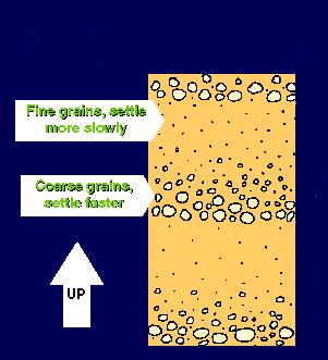
Sandy Beach Morphodynamics. Relationship between sediment size and beach slope
 Sandy Beach Morphodynamics Relationship between sediment size and beach slope 1 Longshore Sorting - Willard Bascom Beach Slope, Grain Size, and Wave Energy Beach at Sandwich Bay, Kent, UK near the Straights
LAKKOPETRA (GREECE) EUROSION Case Study. Contact: Kyriakos SPYROPOULOS. TRITON Consulting Engineers. 90 Pratinou Str Athens (GREECE)
 EUROSION Case Study. Contact: Kyriakos SPYROPOULOS. TRITON Consulting Engineers. 90 Pratinou Str Athens (GREECE)") LAKKOPETRA (GREECE) Contact: Kyriakos SPYROPOULOS TRITON Consulting Engineers 90 Pratinou Str. 11634 Athens (GREECE) Tel: +32 10 729 57 61 Fax: +32 10 724 33 58 e-mail: kspyropoulos@tritonsa.gr 19 1 1.
LAKKOPETRA (GREECE) Contact: Kyriakos SPYROPOULOS TRITON Consulting Engineers 90 Pratinou Str. 11634 Athens (GREECE) Tel: +32 10 729 57 61 Fax: +32 10 724 33 58 e-mail: kspyropoulos@tritonsa.gr 19 1 1.
Figure 38. Locations of the 28 NJBPN profile stations in Ocean County, NJ.
 55 Figure 38. Locations of the 28 NJBPN profile stations in Ocean County, NJ. 56 Individual Site Descriptions: Northern Ocean County recovered its beaches approaching pre-hurricane Sandy elevation or width,
RACE BRIEFING PACK. 7th November 2015
 RACE BRIEFING PACK 7th November 2015 Dear runner, Here s all you need to know about this year s Glen Ogle 33 Ultra Marathon. I know we say it ever year, but we can t get over how popular the race has become,
NORTH HAVEN NORTH HAVEN SLSC
 NORTH HAVEN NORTH HAVEN SLSC Patrols: November to March, weekends and public holidays North Haven beach is the product of a major redevelopment of the northern part of the Adelaide coast. In the 1980s,
G. Meadows, H. Purcell and L. Meadows University of Michigan
 www.coj.net/departments/fire+and+rescue/emergency+preparedness/rip+current.htm G. Meadows, H. Purcell and L. Meadows Over 80% of all surf related rescues are attributable to Rip Currents According to the
Waves Unit II: Waves in the Ocean (3.5 pts)
") T. James Noyes, El Camino College Waves Unit I: The Nature of Waves (Topic 5A-1) page 1 Name: Section: Waves Unit II: Waves in the Ocean (3.5 pts) Changes in Wave Height, Wavelength, and Wave Speed at
T. James Noyes, El Camino College Waves Unit I: The Nature of Waves (Topic 5A-1) page 1 Name: Section: Waves Unit II: Waves in the Ocean (3.5 pts) Changes in Wave Height, Wavelength, and Wave Speed at
SPORT CLIMBS HORI BAY. OCTOBER 2014 EDITION Climbing near Nelson, New Zealand
 SPORT CLIMBS HORI BAY OCTOBER 2014 EDITION Climbing near Nelson, New Zealand Another day at Hori Bay Hori Bay, New Zealand Sectors 1 The Arena The Sideshow 2 3 5 6 8 WARNING! Climbing is a potentially
Activity #1: The Dynamic Beach
 Activity #1: The Dynamic Beach Beach Profiling By Betsy Sheffield, COASTeam Program, College of Charleston, Charleston, SC Subjects: Science, Math Skills: Analysis, description, listing, research, small
Nearshore Morphodynamics. Bars and Nearshore Bathymetry. Sediment packages parallel to shore, that store beach sediment
 Nearshore Morphodynamics http://coastal.er.usgs.gov/bier/images/chandeleur-xbeach-lg.jpg Bars and Nearshore Bathymetry Sediment packages parallel to shore, that store beach sediment Can be up to 50 km
Chapter 20 Lecture. Earth: An Introduction to Physical Geology. Eleventh Edition. Shorelines. Tarbuck and Lutgens Pearson Education, Inc.
 Chapter 20 Lecture Earth: An Introduction to Physical Geology Eleventh Edition Shorelines Tarbuck and Lutgens The Shoreline: A Dynamic Interface The Coastal Zone The shoreline is constantly modified by
Directed Reading. Section: Ocean Currents. a(n). FACTORS THAT AFFECT SURFACE CURRENTS
. FACTORS THAT AFFECT SURFACE CURRENTS") Skills Worksheet Directed Reading Section: Ocean Currents 1. A horizontal movement of water in a well-defined pattern is called a(n). 2. What are two ways that oceanographers identify ocean currents? 3.
Skills Worksheet Directed Reading Section: Ocean Currents 1. A horizontal movement of water in a well-defined pattern is called a(n). 2. What are two ways that oceanographers identify ocean currents? 3.
1 Shoreline Erosion and Deposition
 CHAPTER 12 1 Shoreline Erosion and Deposition SECTION Agents of Erosion and Deposition BEFORE YOU READ After you read this section, you should be able to answer these questions: What is a shoreline? How
FLY FISHING BOWRIVER. THANK YOU FOR BOOKING WITH US
 FLY FISHING BOWRIVER www.flyfishingbowriver.com THANK YOU FOR BOOKING WITH US 2 Thank you for booking with us! Just a few things to make your trip even more awesome! Remember we will be in touch with in
IMPORTANT UPDATES (07/26/2017) New Course Guides for 2017! Skratch Labs now being served at Aid Stations
 New Course Guides for 2017! Skratch Labs now being served at Aid Stations") HALF MARATHON COURSE GUIDE IMPORTANT UPDATES (07/26/2017) New Course Guides for 2017! Skratch Labs now being served at Aid Stations RACE DAY CHECKLIST PRE-RACE PREPARATION Review the shuttle and parking
HALF MARATHON COURSE GUIDE IMPORTANT UPDATES (07/26/2017) New Course Guides for 2017! Skratch Labs now being served at Aid Stations RACE DAY CHECKLIST PRE-RACE PREPARATION Review the shuttle and parking
HURRICANE SANDY LIMITED REEVALUATION REPORT UNION BEACH, NEW JERSEY DRAFT ENGINEERING APPENDIX SUB APPENDIX D SBEACH MODELING
 HURRICANE SANDY LIMITED REEVALUATION REPORT UNION BEACH, NEW JERSEY DRAFT ENGINEERING APPENDIX SUB APPENDIX D SBEACH MODELING Rev. 18 Feb 2015 1 SBEACH Modeling 1.0 Introduction Following the methodology
Lesson 46: Properties of Waves
 Lesson 46: Properties of Waves Illustration 1: Is that Mr.C??? When you hear the word waves you probably have visions of hanging ten off of Waikiki. Although these are waves, we will be looking at a more