Breakwaters and closure dams CT 5308 Exercise 2011: Pointe Noire, Congo
|
|
|
- Kevin Burns
- 6 years ago
- Views:
Transcription


1 Breakwaters and closure dams CT 5308 Exercise 2011: Pointe Noire, Congo The town of Pointe Noire is the main port city in the Republic of the Congo and sits on the south-western African coast some 150 km north of the mouth of the Congo River. The harbour is located in a natural bay protected in the south-west by a sand spit. In the 1930s this spit has been protected with revetments on the sea side, and the protection was extended by a 400 m long breakwater in The last time some repair work was done on this breakwater was in At present two developments are taking place: - The area behind the existing (1968) breakwater is upgraded to create a container terminal. The existing breakwater is in a deteriorated state and must be rehabilitated to offer sufficient protection for this new land use. - The breakwater will be extended again, by another 300 metres in order to reduce the waves in the bay and improve the navigability of the access channel. The figures below illustrate the situation. Figure 1: Project location (left) general situation showing the town, the bay and the port area (right)
 - determine your own boundary conditions and")
2 300 m extension Access channel Existing 1968 breakwater Container terminal Inner harbour Figure 2: Detail of the harbour with sketch of present developments Your assignment is as follows: - make a design for either the rehabilitation of the existing breakwater, or for the new breakwater extension (which of the two depends on your group number) - determine your own boundary conditions and design criteria - each group must use a different armour type, see table below - describe how you would build this breakwater (which equipment type, which building sequence etc) and give a estimate of the time needed to construct it At the end of the week, on Friday , you must hand in a report and give a short presentation (10 minutes). Further details are given below.
3 Boundary conditions For an overview of internet sources of information is referred to the Virtual Knowledge Centre Water, which you can reach via Under the heading data information on data sources is available. For detailed information regarding the bed topography is referred to the digital nautical map, available in the TU-Delft map room (in the library of the building of Architecture, Julianalaan). Also you may use the printed nautical charts available in the TU map-room Tidal information is available from various sources, for example the website of the UK Hydrographic office (only one week) or the French Hydrographic office (only one week ahead, but you may calculate the whole previous year). For some locations in the world T-bone is a good option. You will have to determine your own design water levels. For waves you should use the Argoss database ( For the Argoss database a password is required. The password will be given during the instruction session. You should also use the data from Global wave Statistics, accessible via VKC-water. Click on the right area to download a pdf with data. For the transformation of waves from deep to shallow water you may use SwanOne or/and the wave ray model built in into the Argoss system. The Argoss wave ray system is rather time consuming. To divide the load on the server groups A to O should use and group P to U should use Only a limited number of users can use the package at the same time. You may select one of the following 5 usernames: VerhagenA, VerhagenB, VerhagenC, VerhagenD or VerhagenE For the calculation of the armour units you may use Breakwat. In Cress you will also find a routine for application of the Goda method for vertical wall breakwaters. Breakwat can be accessed via the student network Start Programs Delftchess Breakwat3.1 All required dimensions, distances etc of the coastline and the port area can be measured in Google Earth or from the nautical maps. You do not have to consider the quality of the subsoil, so you do not have to make calculations for geotechnical slope stability, bearing capacity, settlements etc. You can assume that the seabed consists of medium coarse sand (400 microns). Also design guidelines can be found at the VKC-water. Go to the header Codes, Standards and Design Guidelines. All PIANC publications can be found in the VKCwater via repositories and then Digital reports and books.
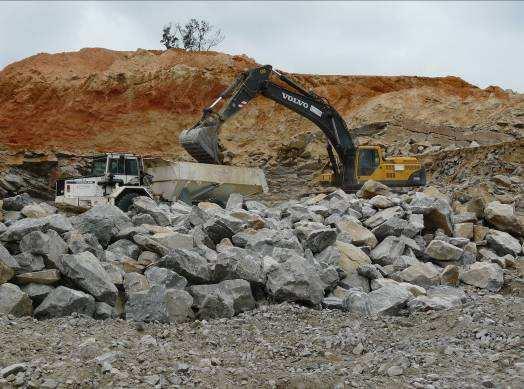
4 Local circumstances The Republic of the Congo is a developing country, so the local circumstances may sometimes be less than ideal for a breakwater construction project. However the port of Pointe Noire itself is relatively well-developed and most common items such as fuel and repair facilities are available. There is also a dock that can be used for the construction of caissons. Other things to consider are: - the present harbour areas are congested and it may not be possible to find space for e.g. stockpiles. - the state of the roads is very poor and traffic through the city of Pointe Noire itself is almost impossible at daytime because of traffic jams. There is an old railway connection to the harbour but a serious amount of maintenance is required before it can be used. - there are rock quarries in the mountains, some 200 km inland from the city. You can assume that these quarries can deliver sufficient quantities of large rocks needed for this project but they can only be reached by badly maintained roads. In particular during the rainy season the state of the roads can be extremely poor. Also, the western coast of Africa is known for its harsh wave climate and long periods of persistent swell waves. You must take this into account when you determine your construction methods and planning. The local circumstances are further illustrated by the pictures on the next pages. Details of the assignment On Friday every group will: - Give an oral presentation, explaining the cross sectional profile of the designed section of the breakwater, including the choices made. The total duration of the presentation should be maximum 10 minutes, followed by 5 minutes of questions by other groups. All groups present will comment on the presentations of other groups. - Hand in a report containing: o a drawing with a design of the cross-sectional profile of the breakwater. On the drawing the contractor has to be able to find sufficient information regarding weight of armour units, slopes, crest height, toe, sub-layers etc o a project planning for the construction of your section of the breakwater. The planning should contain enough details to understand the various construction activities, sequence and estimated durations o Additional information, calculations etc plus explanation of the choices. The total size of the report-text should be in the order of 5 pages text (figures are additional to the 5 pages).
5 Each group will design a slightly different section; the differences are the main armour type, the location of the section (either on the existing breakwater or on the new breakwater) and the design lifetime for the breakwater (either 20 years or 50 years). The details for your group depend on your group number, as per the following table: Armour Design life 20 years Design life 50 years Existing breakwater New breakwater Existing breakwater New breakwater Natural rock A G N T Antifer cubes B H O U CoreLoc C I P V Dolos D J Q W X-bloc E K R X Berm breakwater F L S Y Monolithic caissons M Z Make calculations with a classical approach, see if you can use PIANC guidelines, and see if it is possible (and useful) to make a full probabilistic approach. Presentations are on Friday 25 March in room The morning groups start at 8:30. The afternoon groups start at 13:00 hrs.


6 1) Transport road to rock quarry site 2) State of the roads in the rainy season

7 3) Quarry equipment 4) Quarry equipment


8 5) Congestion on the roads near Pointe Noire city 6) Access road to existing breakwater


9 7) State of the rail road at the port area 8) Another view of the rail road


10 9) View of the container stockyard from the existing breakwater 10) Another view of the container stockyard


11 11) Wave overtopping on existing breakwater in normal conditions 12) Swell wave at the head of the existing breakwater
Structure Failure Modes
 US Army Corps Monitoring and Maintenance of Coastal Infrastructure Structure Failure Modes Steven A. Hughes, PhD, PE Coastal and Hydraulics Laboratory US Army Engineer Research and Development Center Waterways
Hydrodynamic and hydrological modelling to support the operation and design of sea ports
 Hydrodynamic and hydrological modelling to support the operation and design of sea ports Data needs and examples Martijn de Jong (port/nautical requirements, waves, currents) Sofia Caires (mean and extreme
OECS Regional Engineering Workshop September 29 October 3, 2014
 B E A C H E S. M A R I N A S. D E S I G N. C O N S T R U C T I O N. OECS Regional Engineering Workshop September 29 October 3, 2014 Coastal Erosion and Sea Defense: Introduction to Coastal/Marine Structures
THE WAVE CLIMATE IN THE BELGIAN COASTAL ZONE
 THE WAVE CLIMATE IN THE BELGIAN COASTAL ZONE Toon Verwaest, Flanders Hydraulics Research, toon.verwaest@mow.vlaanderen.be Sarah Doorme, IMDC, sarah.doorme@imdc.be Kristof Verelst, Flanders Hydraulics Research,
REVETMENTS. Purposes and Operational Constraints. Purposes Erosion control o o. Revetment Design 4/5/2016. CE A676 Coastal Engineering
 REVETMENTS Ijsseldam, the Netherlands Orson P. Smith, PE, Ph.D. Instructor Purposes and Operational Constraints Purposes Erosion control o o Embankment Toe protection for a seawall, retaining wall or other
3 Maps and Charts In order to navigate we need to use some form of map. The two choices are nautical charts, or land maps.
 13 3 Maps and Charts In order to navigate we need to use some form of map. The two choices are nautical charts, or land maps. Charts Nautical Charts only show the land detail that is visible from the sea.
(Refer Slide Time: 1:01)
") Port and Harbour Structures. Professor R. Sundaradivelu. Department of Ocean Engineering. Indian Institute of Technology, Madras. Module-3. Lecture-11. Breakwater. So we have so far discussed 5 lectures,
Port and Harbour Structures. Professor R. Sundaradivelu. Department of Ocean Engineering. Indian Institute of Technology, Madras. Module-3. Lecture-11. Breakwater. So we have so far discussed 5 lectures,
2. Water levels and wave conditions. 2.1 Introduction
 18 2. Water levels and wave conditions 2.1 Introduction This Overtopping Manual has a focus on the aspects of wave run-up and wave overtopping only. It is not a design manual, giving the whole design process
WAVE OVERTOPPING OF RUBBLE MOUND BREAKWATERS
 WAVE OVERTOPPING OF RUBBLE MOUND BREAKWATERS Mogens Hebsgaard 1, Peter Sloth 1, and tegen Juhl 2 Abstract A general expression for the overtopping discharge of a rubble mound breakwater has been derived
INTRODUCTION TO COASTAL ENGINEERING
 The University of the West Indies Organization of American States PROFESSIONAL DEVELOPMENT PROGRAMME: COASTAL INFRASTRUCTURE DESIGN, CONSTRUCTION AND MAINTENANCE A COURSE IN COASTAL DEFENSE SYSTEMS I CHAPTER
Understanding the Tsunami Wave
 The First Tsunami attack on Sri Lanka Krakatoa Island 27 th August 1883 Understanding the Tsunami Wave Generation Propagation Nearshore Transformation Shoreline Entry Inland Dissipation 1 Generation and
Chapter 4: Google Earth Exercise
 Chapter 4: Google Earth Exercise Exercise 1 Visualizing the Three Gorges Dam Hydroelectric Project The Three Gorges Dam was the largest infrastructure project in China since the Great Wall. Completed in
Introduction to Roadway Design
 Chapter Introduction to Roadway Design 1 This chapter lays the foundation for the Roadway Design course. You examine the roadway design workflow and the completed drawing files and review the project scope,
HELCOM Submerged and The Nairobi International Convention. HELCOM Submerged Expert Group meeting in Bonn, Germany, 22 nd of April 2015
 HELCOM Submerged and The Nairobi International Convention HELCOM Submerged Expert Group meeting in Bonn, Germany, 22 nd of April 2015 The Nairobi International Convention on the Removal of Wrecks 2007
INTRODUCTION TO COASTAL ENGINEERING AND MANAGEMENT
 Advanced Series on Ocean Engineering Volume 16 INTRODUCTION TO COASTAL ENGINEERING AND MANAGEMENT J. William Kamphuis Queen's University, Canada World Scientific Singapore New Jersey London Hong Kong Contents
HURRICANE SANDY LIMITED REEVALUATION REPORT UNION BEACH, NEW JERSEY DRAFT ENGINEERING APPENDIX SUB APPENDIX D SBEACH MODELING
 HURRICANE SANDY LIMITED REEVALUATION REPORT UNION BEACH, NEW JERSEY DRAFT ENGINEERING APPENDIX SUB APPENDIX D SBEACH MODELING Rev. 18 Feb 2015 1 SBEACH Modeling 1.0 Introduction Following the methodology
Soft Designs for a Harsh Climate: Trends in Coastal Engineering
 Alaska Department of Transportation & Public Facilities Ruth Carter, PE, and Harvey Smith, PE Coastal Engineering Section 20 October 2014 Soft Designs for a Harsh Climate: Trends in Coastal Engineering
Low-crested offshore breakwaters: a functional tool for beach management
 Environmental Problems in Coastal Regions VI 237 Low-crested offshore breakwaters: a functional tool for beach management K. Spyropoulos & E. Andrianis TRITON Consulting Engineers, Greece Abstract Beach
BILLY BISHOP TORONTO CITY AIRPORT PRELIMINARY RUNWAY DESIGN COASTAL ENGINEERING STUDY
 Bâtiment Infrastructures municipales Transport Industriel Énergie Environnement BILLY BISHOP TORONTO CITY AIRPORT PRELIMINARY RUNWAY DESIGN COASTAL ENGINEERING STUDY N. Guillemette 1, C. Glodowski 1, P.
Australian Coastal Councils Conference
 Australian Coastal Councils Conference Kiama March 2019 Where Has My Beach Gone? (and what can I do about it?) Dr Andrew McCowan Water Technology Where Has My Beach Gone? Where Has My Beach Gone? Where
Implications of proposed Whanganui Port and lower Whanganui River dredging
 PO Box 637 Wanganui 4540 Attention: Rowan McGregor Dear Rowan 1 Summary We understand that it has been proposed to bring large vessels into the Port at Whanganui requiring the excavation of a channel up
Eilat 's artificial lagoons project on the Red Sea - Israel R. Raviv Ir. R. Raviv, Coastal Engineering Ltd., P.O. Box 7322, z/b 37072,
 Eilat 's artificial lagoons project on the Red Sea - Israel R. Raviv Ir. R. Raviv, Coastal Engineering Ltd., P.O. Box 7322, z/b 37072, Introduction Eilat city is located in the southern part of the state
4/20/17. #32 - Coastal Erosion Case Histories - Lake Michigan
 Writing Assignment Due Monday by 11:59 pm #32 - Coastal Erosion Case Histories - Lake Michigan See main class web pages for detailed instructions Submit papers Illinois Compass No copying: Compass will
.3 the correct operation of the communications medium between the navigation bridge and the steering gear compartment.
 221-389.2 a visual inspection of the steering gear and its associated links; and.3 the correct operation of the communications medium between the navigation bridge and the steering gear compartment. 3.1
The History of Coastal Flood Hazard Assessments in the Great Lakes
 The History of Coastal Flood Hazard Assessments in the Great Lakes Brian A. Caufield, P.E., CFM June 23, 2016 2 The Great Lakes Some Statistics Courtesy of Great Lakes Information Network One-fifth of
Visiting Lake Macquarie
 Visiting Lake Macquarie Lake Macquarie is the largest coastal salt water lake in Australia and is a prime boating destination for both small and large vessels. Many sailing regattas and fishing activities
OPERATIONS SEAFARER CERTIFICATION GUIDANCE NOTE SA MARITIME QUALIFICATIONS CODE. Deck: Chart Work
 Page 1 of 6 Compiled by Approved by Chief Examiner Syllabus Committee: 26 February 2013 OPERATIONS SEAFARER CERTIFICATION GUIDANCE NOTE SA MARITIME QUALIFICATIONS CODE Deck: Chart Work Page 2 of 6 COLUMN
Available online at ScienceDirect. Procedia Engineering 116 (2015 )
") Available online at www.sciencedirect.com ScienceDirect Procedia Engineering 116 (2015 ) 320 325 8th International Conference on Asian and Pacific Coasts (APAC 2015) Department of Ocean Engineering, IIT
Available online at www.sciencedirect.com ScienceDirect Procedia Engineering 116 (2015 ) 320 325 8th International Conference on Asian and Pacific Coasts (APAC 2015) Department of Ocean Engineering, IIT
EMPA 2017 How can the S-102 Bathymetric Surface Product improve safety in navigation and pilotage?
 EMPA 2017 How can the S-102 Bathymetric Surface Product improve safety in navigation and pilotage? Operated by the Norwegian Mapping Authority, Hydrographic Service FREEDOM TO CHOOSE Content What is the
ORAN HIGHWAY REVETMENT DESIGN
 ORAN HIGHWAY REVETMENT DESIGN Dr. Işıkhan Güler 2, Erdinç Söğüt 1 (MSc), Deniz Velioğlu 2 (MSc), Dr. Hülya Karakuş Cihan 1, Dr. Mustafa Esen 1, Prof. Dr. Ayşen Ergin 2, Prof. Dr. Ahmet Cevdet Yalçıner
CASE STUDIES IN DAMAGE AND REPAIR STRATEGIES FOR TRAINING WALLS AND BREAKWATERS ON THE NSW COASTLINE POST-JUNE 2016 STORM
 CASE STUDIES IN DAMAGE AND REPAIR STRATEGIES FOR TRAINING WALLS AND BREAKWATERS ON THE NSW COASTLINE POST-JUNE 2016 STORM I Jayewardene 1, B Blumberg 1, E Couriel 1, A Hartley 2, R Main 2, K Morton 2,
Marine Renewables Industry Association. Marine Renewables Industry: Requirements for Oceanographic Measurements, Data Processing and Modelling
 Marine Renewables Industry Association Marine Renewables Industry: Requirements for Oceanographic Measurements, Data Processing and Modelling October 2009 Table of Contents 1. Introduction... 1 2. Measurements
WALKABILITY SURVEY IN ASIAN CITIES
 WALKABILITY SURVEY IN ASIAN CITIES This section describes the methodology of the surveys for the benefit of the enumerators (surveyors) with some sample maps for illustration. The methodology for the survey
then extrapolated to larger area just based on the length of bank [that actually falls in this category].
![then extrapolated to larger area just based on the length of bank [that actually falls in this category].](/thumbs/73/69159506.jpg "then extrapolated to larger area just based on the length of bank [that actually falls in this category].") Ken Rood: Good morning, all. You'll probably be glad to know I'm the last speaker of the day. I'm never sure if that's a good thing or not. But [lucky me]. And I'm going to talk today -- the title of the
Ken Rood: Good morning, all. You'll probably be glad to know I'm the last speaker of the day. I'm never sure if that's a good thing or not. But [lucky me]. And I'm going to talk today -- the title of the
Hydrographic Surveying Methods, Applications and Uses
 Definition: Hydrographic Surveying Methods, Applications and Uses It is the branch of surveying which deals with any body of still or running water such as a lake, harbor, stream or river. Hydrographic
MODELING OF CLIMATE CHANGE IMPACTS ON COASTAL STRUCTURES - CONTRIBUTION TO THEIR RE-DESIGN
 Proceedings of the 14 th International Conference on Environmental Science and Technology Rhodes, Greece, 3-5 September 2015 MODELING OF CLIMATE CHANGE IMPACTS ON COASTAL STRUCTURES - CONTRIBUTION TO THEIR
APPLICATION OF SHORE PROTECTION SCHEMES IN HORNB^K Mads Peder J0rgensen ' Peer Skaarup 2 Karsten Mangor 3 J0rgen Juhl 4
 APPLICATION OF SHORE PROTECTION SCHEMES IN HORNB^K Mads Peder J0rgensen ' Peer Skaarup 2 Karsten Mangor 3 J0rgen Juhl 4 ABSTRACT Hornbask Harbour was built more than a hundred years ago on a sandy coast
Lecture Outlines PowerPoint. Chapter 15 Earth Science, 12e Tarbuck/Lutgens
 Lecture Outlines PowerPoint Chapter 15 Earth Science, 12e Tarbuck/Lutgens 2009 Pearson Prentice Hall This work is protected by United States copyright laws and is provided solely for the use of instructors
The Islands. Barbados. A prefeasibility study. R. Drieman M. Hinborch M. Monden E.A.J. Vendrik
 The Islands Barbados A prefeasibility study R. Drieman M. Hinborch M. Monden E.A.J. Vendrik General notice to the reader: In the academic programme for Hydraulic Engineering we have in the 4th year (i.e.
Aspects related to design and construction of breakwaters in deep water by Hans F. Burcharth Aalborg University, Denmark
 Aspects related to design and construction of breakwaters in deep water by Hans F. Burcharth Aalborg University, Denmark Contents of presentation Introductory characterization of the environment Rubble
Wave Overtopping of Seawalls. Design and Assessment Manual. HR Wallingford Ltd. February R&D Technical Report W178. R&D Technical Report W178
 Wave Overtopping of Seawalls Design and Assessment Manual HR Wallingford Ltd February 1999 R&D Technical Report W178 R&D Technical Report W178 Commissioning Organisation Environment Agency Rio House Waterside
Notice of operations at London Array Offshore Wind Farm
 London Array Ltd. Construction Management Port of Ramsgate Military Road Ramsgate CT11 9LG www.londonarray.com Notice of operations at London Array Offshore Wind Farm Date of Notice: June 19th 2011 Notice
ECONOMIC OPTIMIZATION OF BREAKWATERS
 Delft University of Technology Additional Graduation Work (CIE5050-09) ECONOMIC OPTIMIZATION OF BREAKWATERS Case study: Maintenance of Port of Constantza s Northern Breakwater CAROLINA PICCOLI Supervision:
THE CHALLENGES OF A LARGE-AREA BATHYMETRIC SURVEY
 THE CHALLENGES OF A LARGE-AREA BATHYMETRIC SURVEY Agenda: - Introduction - Tender - Project Planning - Survey - Processing - Delivery - Conclusion 2 Introduction We know less of the oceans at our feet,
Tsunami STUDENT ACTIVITIES
 19 Tsunami STUDENT ACTIVITIES STUDENT AC TT SU I VNI TAIM E SI 20 RUN-UP ON LLEWELLYN Recommended age: Upper primary to secondary The Tsunami Warning Centre (TWC) in Bay Town on Llewellyn Island is keeping
Uncertainty Estimates in Satellite Derived Bathymetry
 Uncertainty Estimates in Satellite Derived Bathymetry Richard Flemmings, TCarta #chcnsc2018 Introduction and Overview 1. TCarta 2. Satellite Derived Bathymetry Overview 3. Satellite Derived Bathymetry
TITLE: COASTAL EROSION AND LANDFORMS.
 TITLE: COASTAL EROSION AND LANDFORMS. AIM: What are the factors that influence the formation of coastal features along Fishing Pond beach Trinidad? LOCATION OF FIELD STUDY: The study was carried out in
Mouth of the Columbia River Jetties Three-Phase Construction Plan
 Mouth of the Columbia River Jetties Three-Phase Construction Plan Project Overview October 9, 2012 US Army Corps of Engineers MCR Jetties Major Rehabilitation Sand Island pile dikes 1930-1935 Columbia
Oceans and Coasts. Chapter 18
 Oceans and Coasts Chapter 18 Exploring the oceans The ocean floor Sediments thicken and the age of the seafloor increases from ridge to shore The continental shelf off the northeast United States Constituent
Risk Awareness Key to a Sustainable Design Approach for Breakwater Armouring
 Risk Awareness Key to a Sustainable Design Approach for Breakwater Armouring J.S. Reedijk, Delta Marine Consultants, Gouda, The Netherlands M. Muttray, Delta Marine Consultants, Gouda, The Netherlands
DESIGN OF SCOUR PROTECTION FOR THE BRIDGE PIERS OF THE 0RESUND LINK
 DESIGN OF SCOUR PROTECTION FOR THE BRIDGE PIERS OF THE 0RESUND LINK Lars Kirkegaard 1, Mogens Hebsgaard 2 and Ole Juul Jensen 3 Abstract The 0resund Link between Denmark and Sweden consists of a cable
Chart Features Maritime maps and Admiralty charts have these features:
 Introduction to Charts A chart or map of the area is an important safety item to carry on board. It allows the Master to obtain knowledge of the area to be travelled, and indicates the navigable channels
Ennore Coal Port Project: Port Basin and Entrance Channel
 Ennore Coal Port Project: Port Basin and Entrance Channel André Luypaert Ennore Coal Port Project: Port Basin and Entrance Channel Abstract The Chennai Port on the eastern coast of India is the main port
Activities of KHOA on creation of S-10X test data sets and S-100 sea trial
 Activities of KHOA on creation of S-10X test data sets and S-100 sea trial Submitted by: Executive Summary: Related Documents: Related Projects: Republic Of Korea (KHOA) KHOA has been conducting a research
Chapter 10 Lecture Outline. The Restless Oceans
 Chapter 10 Lecture Outline The Restless Oceans Focus Question 10.1 How does the Coriolis effect influence ocean currents? The Ocean s Surface Circulation Ocean currents Masses of water that flow from one
Folkestone Fieldwork: Where is Folkestone? What will we be investigating?
 Folkestone Fieldwork: Where is Folkestone? What will we be investigating? Starter: Answer the question. Using your knowledge from last lesson-why does Folkestone require coastal management? Where is Folkestone?
Imagine that you can see a side view of a wave as it approaches a beach. Describe how the wave changes as the wave approaches the beach.
 Geology 101 Name Reading Guide for Ch. 19: Shores and Coastal Processes (p. 612) Waves, Currents, and Tides (p. 614) Waves and Currents (p. 614) Imagine that you can see a side view of a wave as it approaches
Earthen Embankments. turning into larger, more costly repairs. The following. The State Dam Safety Program has inspection
 TOPIC: COMMON PROBLEMS FOR SMALL DAMS WITH CONCRETE CHANNEL SPILLWAYS The State Dam Safety Program has inspection requirements for state regulated dams. A dam, like any man-made structure, will change
V Complying with IHO S-52/S-63/S-64
 Model FEA-2107/2807 V.06.50 Complying with IHO S-52/S-63/S-64 The software has been upgraded to V.06.50 in accordance with the IHO standards. IHO S-52 Ed. 6.1.1 Specifications for Chart Contents and Display
WOODFIBRE LNG VESSEL WAKE ASSESSMENT
 Woodfibre LNG Limited WOODFIBRE LNG VESSEL WAKE ASSESSMENT Introduction Woodfibre LNG Limited (WLNG) intends to build a new LNG export terminal at Woodfibre, Howe Sound, British Columbia. WLNG has engaged
Port of Zeebrugge: Upgrading the Brittannia Dock
 ABSTRACT Port of Zeebrugge: Upgrading the Brittannia Dock by L. Missinne 1 and L. Van Damme 2 The Flemish authority started with the upgrading of the Brittannia Dock in the port of Zeebrugge. The Brittannia
GN21 Frequently Asked Questions For Golfers
 Posting Scores (My Score Center) 1. Click on the Enter Score button to enter an adjusted gross score or click on the Enter Hole-By-Hole Score button to enter your score hole-by-hole. NOTE: to use the Game
Concepts & Phenomena
 Concepts & Phenomena in coastal and port sedimentation R. Kamalian Ports and Maritime Organization of Iran and PIANC-Iran 7 9 December 2015 What is the problem? Many harbours have sedimentation problems
CHAPTER 2. Types and Functions of Coastal Structures TABLE OF CONTENTS. VI-2-1. Applications... VI-2-1
 EM 1110-2-1100 (Part VI) CHAPTER 2 Types and Functions of Coastal Structures TABLE OF CONTENTS VI-2-1. Applications... VI-2-1 Page a. Sea dikes... VI-2-1 b. Seawalls... VI-2-1 c. Revetments... VI-2-1 d.
Chapter 2. Turbulence and the Planetary Boundary Layer
 Chapter 2. Turbulence and the Planetary Boundary Layer In the chapter we will first have a qualitative overview of the PBL then learn the concept of Reynolds averaging and derive the Reynolds averaged
NOTIFICATION AND STANDARD EVENT PLANNING RISK ASSESSMENT GUIDANCE NOTE
 GUIDANCE NOTES ON RISK ASSESSMENT FOR EVENTS IN HARBOUR AUTHORITY AREAS NOTIFICATION AND STANDARD EVENT PLANNING RISK ASSESSMENT GUIDANCE NOTE The DfT (Department for Transport) Port Marine Safety Code
SOME GEOTECHNICAL CONSIDERATIONS FOR PROBABILISTIC ANALYSIS IN SLOPE DESIGN
 SOME GEOTECHNICAL CONSIDERATIONS FOR PROBABILISTIC ANALYSIS IN SLOPE DESIGN ESTEBAN HORMAZABAL Managing Director SRK Consulting Chile USM Estática de Estructuras (CIV-131) Some geotechnical considerations
HYDROSPHERE, OCEANS AND TIDES
 HYDROSPHERE, OCEANS AND TIDES Revision 10x10learning.com 1 Chapter 12. In the Earth s Atmosphere On surface of the Earth Under the ground Hydrosphere comprises of ALL WATER Water Vapour = 0.001% Is very
AD-A II~lllII I I 7
 AD-A284 157 II~lllII CONSTRUCTION OF BREAK WATERS AND BEACEFILL AT THE NAVAL AIR STATION, PATUXENT RIVER, MARYLAND C D.W.Yang, J.McWilliams 2, S.Ming 2 ABSTRACT Construction of the breakwaters and beach
Earth s oceans covers 71 % _ of the planet s surface. In reality, Earth s ocean waters are all. interconnected as part of a single large global ocean.
 Ocean Motion Met 101: Introduction to the World's Oceans Produced by The COMET Program Geography: Name Pd. Earth s oceans covers 71 % _ of the planet s surface. In reality, Earth s ocean waters are all
PHYSICAL MODELLING OF EMERGENCY REPAIRS TO THE MAIN BREAKWATER OF CALSHOT HARBOUR ON TRISTAN DA CUNHA ISLAND
 Proceedings of the 6 th International Conference on the Application of Physical Modelling in Coastal and Port Engineering and Science (Coastlab16) Ottawa, Canada, May 10-13, 2016 Copyright : Creative Commons
The Sea Chart: The Illustrated History Of Nautical Maps And Navigational Charts By John Blake READ ONLINE
 The Sea Chart: The Illustrated History Of Nautical Maps And Navigational Charts By John Blake READ ONLINE If searching for the ebook The Sea Chart: The Illustrated History of Nautical Maps and Navigational
Atlantic Coast of Long Island, Jones Inlet to East Rockaway Inlet, Long Beach Island, NY Construction Update
 Atlantic Coast of Long Island, Jones Inlet to East Rockaway Inlet, Long Beach Island, NY Construction Update June 2016 US Army Corps of Engineers Project Purpose Three specific damage mechanisms of coastal
April 7, Prepared for: The Caribbean Disaster Emergency Response Agency Prepared by: CEAC Solutions Co. Ltd.
 April 7, 2006 Prepared for: The Caribbean Disaster Emergency Response Agency Prepared by: Introduction CEAC Solutions Co. Ltd was commissioned in May 2005 to prepare coastal beach erosion hazard maps for
Chesil Beach, Dorset UK High energy, shingle coastline. Brighton Beach, Sussex UK Pebble beach
 Beaches: Depositional landform Extends from the highest high tide to the lowest low tide. Very important temporary store in coastal system. Accretion: sediment returning to the visible portion of a beach
STUDY ON TSUNAMI PROPAGATION INTO RIVERS
 ABSTRACT STUDY ON TSUNAMI PROPAGATION INTO RIVERS Min Roh 1, Xuan Tinh Nguyen 2, Hitoshi Tanaka 3 When tsunami wave propagation from the narrow river mouth, water surface is raised and fluctuated by long
Table of Contents. Bakkafjara Ferry Port. Icelandic Maritime Administration. Review of IMA provided reports. 1 General
 Icelandic Maritime Administration Bakkafjara Ferry Port Review of IMA provided reports COWI A/S Parallelvej 2 DK-2800 Kongens Lyngby Denmark Tel +45 45 97 22 11 Fax +45 45 97 22 12 wwwcowicom Table of
FOR INFORMATION ONLY. Gold Coast Seaway Channel Scour and Rock Wall Stability Investigation. R.B doc December 2011
 A part of BMT in Energy and Environment Gold Coast Seaway Channel Scour and Rock Wall Stability Investigation R.B18625.001.00.doc December 2011 Gold Coast Seaway Channel Scour and Rock Wall Stability Investigation
Using UNIBEST and Delft3D
 5 th Delft3D-OSS webinar Large scale long-term coastline modelling Using UNIBEST and Delft3D 14 March 2012 Aims Basic information on CL-models Model setup Trigger discussion > Delft3D = open source > UNIBEST
Prevention of Coastal Erosion
 PDHonline Course C219 (5 PDH) Prevention of Coastal Erosion Instructor: Jeffrey Havelin, PE 2012 PDH Online PDH Center 5272 Meadow Estates Drive Fairfax, VA 22030-6658 Phone & Fax: 703-988-0088 www.pdhonline.org
RESEARCH AND ENGINEERING FOR ICZM IN POLAND
 ICZM in a climate change perspective Important issues for the Baltic Sea Lubiatowo, June 2008 RESEARCH AND ENGINEERING FOR ICZM IN POLAND Rafał Ostrowski, Marek Skaja & Marek Szmytkiewicz Institute of
Construction Dewatering
 Construction Dewatering Introduction The control of groundwater is one of the most common and complicated problems encountered on a construction site. Construction dewatering can become a costly issue
Port Sections Guide Section 01
 s Guide 01 Cow Bay Marina Date 10/1/2016 Position (lat / lon) Minimum controlled water depth Chart datum Range of water densities Tidal range alongside Bottom type Dredging regime Distance pilot station
Plot the Path into the Harbor
 Plot the Path into the Harbor By Mary Anne Otten, Rudyard Area Schools and Joan Chadde, Michigan Technological University Subject/Grade: Grade 3 6, Math, Social Studies, Science Duration: 35 minutes Lesson
Measurement of vertical motions of bulk carriers navigating in port entrance channels
 HYDROGRAPHIC CONFERENCE Technical Awareness Seminar 2007 Cape Town, 19 21 June 2007 Measurement of vertical motions of bulk carriers navigating in port entrance channels J Moes CSIR, PO Box 320, Stellenbosch,
Sediment management plans for the Dutch Rhine branches. Arjan Sieben Rijkswaterstaat Waterdienst
 zurück zum Inhaltsverzeichnis zur Kurzfassung Sediment management plans for the Dutch Rhine branches Arjan Sieben Waterdienst 8 oktober 2009 What happens downstream Lobith? Plans and trends Daily practice
UPPER BEACH REPLENISHMENT PROJECT RELATED
 ASSESSMENT OF SAND VOLUME LOSS at the TOWNSHIP of UPPER BEACH REPLENISHMENT PROJECT RELATED to the LANDFALL OF HURRICANE SANDY - PURSUANT TO NJ-DR 4086 This assessment is in response to Hurricane Sandy
Natural Bridges Field Trip Activity
 Natural Bridges Field Trip Activity This is due in class on MONDAY- March 1 - not in sections! Name TA: NOTE ON THE GRADING OF THIS ASSIGNMENT: Many of the questions below (especially in the tidepool part)
Homework 2 Bathymetric Charts [based on the Chauffe & Jefferies (2007)]
![Homework 2 Bathymetric Charts [based on the Chauffe & Jefferies (2007)]](/thumbs/75/72427079.jpg "Homework 2 Bathymetric Charts [based on the Chauffe & Jefferies (2007)]") 1 MAR 110 HW-2 - Bathy Charts Homework 2 Bathymetric Charts [based on the Chauffe & Jefferies (2007)] 2-1. BATHYMETRIC CHARTS Bathymetric charts are maps of a region of the ocean used primarily for navigation
1 MAR 110 HW-2 - Bathy Charts Homework 2 Bathymetric Charts [based on the Chauffe & Jefferies (2007)] 2-1. BATHYMETRIC CHARTS Bathymetric charts are maps of a region of the ocean used primarily for navigation
HARBOUR SEDIMENTATION - COMPARISON WITH MODEL
 HARBOUR SEDIMENTATION - COMPARISON WITH MODEL ABSTRACT A mobile-bed model study of Pointe Sapin Harbour, in the Gulf of St. Lawrence, resulted in construction of a detached breakwater and sand trap to
Nearshore Morphodynamics. Bars and Nearshore Bathymetry. Sediment packages parallel to shore, that store beach sediment
 Nearshore Morphodynamics http://coastal.er.usgs.gov/bier/images/chandeleur-xbeach-lg.jpg Bars and Nearshore Bathymetry Sediment packages parallel to shore, that store beach sediment Can be up to 50 km
Anchoring Is Important
 BCC Sailing Classes - Third Theory Anchoring Anchoring Is Important 1 The Anchor is your last resort. Anchoring Keep off a lee shore. Needs to be shaped (type of anchor) to bury in the type of bottom for
Planning Daily Work Trip under Congested Abuja Keffi Road Corridor
 ISBN 978-93-84468-19-4 Proceedings of International Conference on Transportation and Civil Engineering (ICTCE'15) London, March 21-22, 2015, pp. 43-47 Planning Daily Work Trip under Congested Abuja Keffi
PHYSICAL AND NUMERICAL MODELLING OF WAVE FIELD IN FRONT OF THE CONTAINER TERMINAL PEAR - PORT OF RIJEKA (ADRIATIC SEA)
") PHYSICAL AND NUMERICAL MODELLING OF WAVE FIELD IN FRONT OF THE CONTAINER TERMINAL PEAR - PORT OF RIJEKA (ADRIATIC SEA) DALIBOR CAREVIĆ (1), GORAN LONČAR (1), VLADIMIR ANDROČEC (1) & MARIN PALADIN (1) 1.
PHYSICAL AND NUMERICAL MODELLING OF WAVE FIELD IN FRONT OF THE CONTAINER TERMINAL PEAR - PORT OF RIJEKA (ADRIATIC SEA) DALIBOR CAREVIĆ (1), GORAN LONČAR (1), VLADIMIR ANDROČEC (1) & MARIN PALADIN (1) 1.
NIGERIAN NOTICES TO MARINERS November 2017 EDITION PUBLISHED BY THE HYDROGRAPHIC OFFICE LAGOS. Notice 01 November 2017 Supplied Gratis
 NIGERIAN NOTICES TO MARINERS November 2017 EDITION PUBLISHED BY THE HYDROGRAPHIC OFFICE LAGOS Notice 01 November 2017 Supplied Gratis November 2017 CONTENTS I II Explanatory Notes and Index Nigerian Navy
Overview. Beach Features. Coastal Regions. Other Beach Profile Features. CHAPTER 10 The Coast: Beaches and Shoreline Processes.
 Overview CHAPTER 10 The Coast: Beaches and Shoreline Processes Coastal regions constantly change. The beach is a dominant coastal feature. Wave activity continually modifies the beach and coastal areas.
VESSEL TRANSIT SCHEDULING AT THE PANAMA CANAL NUMBER AND ORDER OF VESSELS IN THE SCHEDULE
 VESSEL TRANSIT SCHEDULING AT THE PANAMA CANAL This document intends to provide our clients with a better understanding of vessel scheduling in the Panama Canal. For any questions not addressed in this
A: Formalities. DELOS WP 1.1 Inventory on LCS, questionnaire, detailed description, revision D AUTH GR. Participant code and who to contact.
 A: Formalities Participant code and who to contact. AUTH GR J. Avgeris E-mail iavgeris@civil.auth.gr This date (today, mm:dd:yyyy) and revision number (A..Z). 17/09/01 Rev A Location of LCS. Patras Gulf,
Reading Material. Inshore oceanography, Anikouchine and Sternberg The World Ocean, Prentice-Hall
 Reading Material Inshore oceanography, Anikouchine and Sternberg The World Ocean, Prentice-Hall BEACH PROCESSES AND COASTAL ENVIRONMENTS COASTAL FEATURES Cross section Map view Terminology for Coastal
Introduction of the term Traffic Control Zone and formalization of Fraser River Traffic Control Zone procedures
 Consideration Report Introduction of the term Traffic Control Zone and formalization of Fraser River Traffic Control Zone procedures Background Under the Canada Marine Act, all Canada Port Authorities