APPENDIX A. Glossary of Terms. Newport Cove, Maine, 12 September, 1958
|
|
|
- Jack Scott Gallagher
- 6 years ago
- Views:
Transcription

1 APPENDIX A Glossary of Terms Newport Cove, Maine, 12 September, 1958
2 The glossary that follows was compiled and reviewed by the staff of the Coastal Engineering Research Center. Although the terms came from many sources, the following publications were of particular value: American Geological Institute (1957) Glossary of Geology and Related Sciences with Supplement, 2d Edition American Geological Institute (1960) Dictionary of Geological Terms, 2nd Edition American Meteorological Society (1959) Glossary of Meteorology Johnson, D.W. (1919) Shove Process and Shoreline Development, John Wiley and Sons, Inc., New York U.S. Army Coastal Engineering Research Center (1966) Shore Protection, Planning and Design, Technical Report No. 4, 3d Edition U.S. Coast and Geodetic Survey (1949) Tide and Current Glossary, Special Publication No. 228, Revised (1949) Edition U.S. Navy Oceanographic Office (1966) Glossary of Oceanographic Terms, Special Publication (SP-35), 2d Edition Wiegel, R.L. (1953) Waves, Tides, Currents and Beaches: Glossary of Terms and List of Standard Symbols. Council on Wave Research, The Engineering Foundation, University of California GLOSSARY OF TERMS ACCRETION. May be either NATURAL or ARTIFICIAL. Natural accretion is the buildup of land, solely by the action of the forces of nature, on a BEACH by deposition of water- or airborne material. Artificial accretion is a similar buildup of land by reason of an act of man, such as the accretion formed by a groin, breakwater, or beach fill deposited by mechanical means. Also AGGRADATION. ADVANCE (of a beach). (1) A continuing seaward movement of the shoreline. (2) A net seaward movement of the shoreline over a specified time. Also PROGRESSION. AGE, WAVE. The ratio of wave velocity to wind velocity (in wave forecasting theory). AGGRADATION. See ACCRETION. ALLUVIUM. Soil (sand, mud, or similar detrital material) deposited by streams, or the deposits formed. ALONGSHORE. Parallel to and near the shoreline; LONGSHORE. A-1
3 AMPLITUDE, WAVE. (1) The magnitude of the displacement of a wave from a mean value. An ocean wave has an amplitude equal to the vertical distance from still-water level to wave crest. For a sinusoidal wave, the amplitude is one-half the wave height. (2) The semirange of a constituent tide. ANTIDUNES. BED FORMS that occur in trains and are in phase with, and strongly interact with, gravity water-surface waves. ANTINODE. See LOOP. ARMOR UNIT. A relatively large quarrystone or concrete shape that is selected to fit specified geometric characteristics and density. It is usually of nearly uniform size and usually large enough to require individual placement. In normal cases it is used as primary wave protection and is placed in thicknesses of at least two units. ARTIFICIAL NOURISHMENT. The process of replenishing a beach with material (usually sand) obtained from another location. ATOLL. A ring-shaped coral reef, often carrying low sand islands, enclosing a lagoon. ATTENUATION. (1) A lessening of the amplitude of a wave with distance from the origin. (2) The decrease of water-particle motion with increasing depth. Particle motion resulting from surface oscillatory waves attenuates rapidly with depth, and practically disappears at a depth equal to a surface wavelength. AWASH. Situated so that the top is intermittently washed by waves or tidal action. Condition of being exposed or just bare at any stage of the tide between high water and chart datum. BACKBEACH. See BACKSHORE. BACKRUSH. The seaward return of the water following the uprush of the waves. For any given tide stage the point of farthest return seaward of the backrush is known as the LIMIT of BACKRUSH or LIMIT BACKWASH. (See Figure A-2.) BACKSHORE. That zone of the shore or beach lying between the foreshore and the coastline comprising the BERM or BERMS and acted upon by waves only during severe storms, especially when combined with exceptionally high water. Also BACKBEACH. (See Figure A-1.) BACKWASH. (1) See BACKRUSH. (2) Water or waves thrown back by an obstruction such as a ship, breakwater, or cliff. BANK. (1) The rising ground bordering a lake, river, or sea; or of a river or channel, for which it is designated as right or left as the observer is facing downstream. (2) An elevation of the sea floor or large area, located on a continental (or island) shelf and over which the depth is relatively shallow but sufficient for safe surface navigation; a group of shoals. (3) In its secondary sense, used only with a qualifying word such as "sandbank" or "gravelbank," a shallow area consisting of shifting forms of silt, sand, mud, and gravel. A-2
4 BAR. A submerged or emerged embankment of sand, gravel, or other unconsolidated material built on the sea floor in shallow water by waves and currents. (See Figures A-2 and A-9.) See BAYMOUTH BAR, CUSPATE BAR. BARRIER BEACH. A bar essentially parallel to the shore, the crest of which is above normal high water level. (See Figure A-9.) Also called OFFSHORE BARRIER and BARRIER ISLAND. BARRIER LAGOON. A bay roughly parallel to the coast and separated from the open ocean by barrier islands. Also, the body of water encircled by coral islands and reefs, in which case it may be called an atoll lagoon. BARRIER REEF. A coral reef parallel to and separated from the coast by a lagoon that is too deep for coral growth. Generally, barrier reefs follow the coasts for long distances and are cut through at irregular intervals by channels or passes. BASIN, BOAT. A naturally or artificially enclosed or nearly enclosed harbor area for small craft. BATHYMETRY. The measurement of depths of water in oceans, seas, and lakes; also information derived from such measurements. BAY. A recess in the shore or an inlet of a sea between two capes or headlands, not so large as a gulf but larger than a cove. (See Figure A-9.) See also BIGHT, EMBAYMENT. BAYMOUTH BAR. A bar extending partly or entirely across the mouth of a bay (see Figure A- 9). BAYOU. A minor sluggish waterway or estuarial creek, tributary to, or connecting, other streams or bodies of water, whose course is usually through lowlands or swamps. Sometimes called SLOUGH. BEACH. The zone of unconsolidated material that extends landward from the low water line to the place where there is marked change in material or physiographic form, or to the line of permanent vegetation (usually the effective limit of storm waves). The seaward limit of a beach--unless otherwise specified--is the mean low water line. A beach includes FORESHORE and BACKSHORE. See also SHORE. (See Figure A-1.) BEACH ACCRETION. See ACCRETION. BEACH BERM. A nearly horizontal part of the beach or backshore formed by the deposit of material by wave action. Some beaches have no berms, others have one or several. (See Figure A-1.) BEACH CUSP. See CUSP. BEACH EROSION. The carrying away of beach materials by wave action, tidal currents, littoral currents) or wind. A-3
5 BEACH FACE. The section of the beach normally exposed to the action of the wave uprush. The FORESHORE of a BEACH. (Not synonymous with SHOREFACE.) (See Figure A- 2.) BEACH FILL. Material placed on a beach to renourish eroding shores. BEACH RIDGE. See RIDGE, BEACH. BEACH SCARP. See SCARP, BEACH. BEACH WIDTH. The horizontal dimension of the beach measured normal to the shoreline. BED FORMS. Any deviation from a flat bed that is readily detectable by eye and higher than the largest sediment size present in the parent bed material; generated on the bed of an alluvial channel by the flow. BEDLOAD. See LOAD. BENCH. (1) A level or gently sloping erosion plane inclined seaward. (2) A nearly horizontal area at about the level of maximum high water on the sea side of a dike. BENCH MARK. A permanently fixed point of known elevation. A primary bench mark is one close to a tide station to which the tide staff and tidal datum originally are referenced. BERM, BEACH. See BEACH BERM. BERM CREST. The seaward limit of a berm. Also called BERM EDGE. (See Figure A-1.) BIGHT. A bend in a coastline forming an open bay. A bay formed by such a bend. (See Figure A-8.) BLOWN SANDS. See EOLIAN SANDS. BLUFF. A high, steep bank or cliff. BOLD COAST. A prominent landmass that rises steeply from the sea. BORE. A very rapid rise of the tide in which the advancing water presents an abrupt front of considerable height. In shallow estuaries where the range of tide is large, the high water is propagated inward faster than the low water because of the greater depth at high water. If the high water overtakes the low water, an abrupt front is presented, with the high-water crest finally falling forward as the tide continues to advance. Also EAGER. BOTTOM. The ground or bed under any body of water; the bottom of the sea. (See Figure A-1.) A-4
6 BOTTOM (nature of). The composition or character of the bed of an ocean or other body of water (e.g., clay, coral, gravel, mud, ooze, pebbles, rock, shell, shingle, hard, or soft). BOULDER. A rounded rock more than 10 inches in diameter; larger than a cobblestone. See SOIL CLASSIFICATION. BREAKER. A wave breaking on a shore, over a reef, etc. Breakers may be classified into four types (see Figure A-4): SPILLING--bubbles and turbulent water spill down front face of wave. The upper 25 percent of the front face may become vertical before breaking. Breaking generally occurs over quite a distance. PLUNGING--crest curls over air pocket; breaking is usually with a crash. Smooth splash-up usually follows. COLLAPSING--breaking occurs over lower half of wave, with minimal air pocket and usually no splash-up. Bubbles and foam present. (See Figure 2-77). SURGING--wave peaks up, but bottom rushes forward from under wave, and wave slides up beach face with little or no bubble production. Water surface remains almost plane except where ripples may be produced on the beachface during runback. BREAKER DEPTH. The still-water depth at the point where a wave breaks. Also called BREAKING DEPTH. (See Figure A-2). BREAKWATER. A structure protecting a shore area, harbor, anchorage, or basin from waves. BULKHEAD. A structure or partition to retain or prevent sliding of the land. purpose is to protect the upland against damage from wave action. A secondary BUOY. A float; especially a floating object moored to the bottom to mark a channel, anchor, shoal, rock, etc. BUOYANCY. The resultant of upward forces, exerted by the water on a submerged or floating body, equal to the weight of the water displaced by this body. BYPASSING, SAND. Hydraulic or mechanical movement of sand from the accreting updrift side to the eroding downdrift side of an inlet or harbor entrance. The hydraulic movement may include natural movement as well as movement caused by man. CANAL. An artificial watercourse cut through a land area for such uses as navigation and irrigation. CANYON. A relatively narrow, deep depression with steep slopes, the bottom of which grades continuously downward. May be underwater (submarine) or on land (subaerial). A-5
7 CAPE. A relatively extensive land area jutting seaward from a continent or large island which prominently marks a change in, or interrupts notably, the coastal trend; a prominent feature. CAPILLARY WAVE. A wave whose velocity of propagation is controlled primarily by the surface tension of the liquid in which the wave is traveling. Water waves of length less than about 1 inch are considered capillary waves. Waves longer than 1 inch and shorter than 2 inches are in an indeterminate zone between CAPILLARY and GRAVITY WAVES. See RIPPLE. CAUSEWAY. A raised road across wet or marshy ground, or across water. CAUSTIC. In refraction of waves, the name given to the curve to which adjacent orthogonals of waves refracted by a bottom whose contour lines are curved, are tangents. The occurrence of a caustic always marks a region of crossed orthogonals and high wave convergence. CAY. See KEY. CELERITY. Wave speed. CENTRAL PRESSURE INDEX (CPI). The estimated minimum barometric pressure in the eye (approximate center) of a particular hurricane. The CPI is considered the most stable index to intensity of hurricane wind velocities in the periphery of the storm; the highest wind speeds are associated with storms having the lowest CPI. CHANNEL. (1) A natural or artificial waterway of perceptible extent which either periodically or continuously contains moving water, or which forms a connecting link between two bodies of water. (2) The part of a body of water deep enough to be used for navigation through an area otherwise too shallow for navigation. (3) A large strait, as the English Channel. (4) The deepest part of a stream, bay, or strait through which the main volume or current of water flows. CHARACTERISTIC WAVE HEIGHT. See SIGNIFICANT WAVE HEIGHT. CHART DATUM. The plane or level to which soundings (or elevations) or tide heights are referenced (usually LOW WATER DATUM). The surface is called a tidal datum when referred to a certain phase of tide. To provide a safety factor for navigation, some level lower than MEAN SEA LEVEL is generally selected for hydrographic charts, such as MEAN LOW WATER or MEAN LOWER LOW WATER. See DATUM PLANE. CHOP. The short-crested waves that may spring up quickly in a moderate breeze, and which break easily at the crest. Also WIND CHOP. CLAPOTIS. The French equivalent for a type of STANDING WAVE. In American usage it is usually associated with the standing wave phenomenon caused by the reflection of a nonbreaking wave train from a structure with a face that is vertical or nearly vertical. Full clapotis is one with 100 percent reflection of the incident wave; partial clapotis is one with less than 100 percent reflection. A-6
8 CLAY. See SOIL CLASSIFICATION. CLIFF. A high, steep face of rock; a precipice. See also SEA CLIFF. CNOIDAL WAVE. A type of wave in shallow water (i.e., where the depth of water is less than 1/8 to 1/10 the wavelength). The surface profile is expressed in terms of the Jacobian elliptic function cn u; hence the term cnoidal. COAST. A strip of land of indefinite width (may be several kilometers) that extends from the shoreline inland to the first major change in terrain features. (See Figure A-1.) COASTAL AREA. The land and sea area bordering the shoreline. (See Figure A-1.) COASTAL PLAIN. The plain composed of horizontal or gently sloping strata of clastic materials fronting the coast, and generally representing a strip of sea bottom that has emerged from the sea in recent geologic time. COASTLINE. (1) Technically, the line that forms the boundary between the COAST and the SHORE. (2) Commonly, the line that forms the boundary between the land and the water. COBBLE (COBBLESTONE). See SOIL CLASSIFICATION. COMBER. (1) A deepwater wave whose crest is pushed forward by a strong wind; much larger than a whitecap. (2) A long-period breaker. CONTINENTAL SHELF. The zone bordering a continent and extending from the low water line to the depth (usually about 180 meters) where there is a marked or rather steep descent toward a greater depth. CONTOUR. A line on a map or chart representing points of equal elevation with relation to a DATUM. It is called an ISOBATH when connecting points of equal depth below a datum. Also called DEPTH CONTOUR. CONTROLLING DEPTH. The least depth in the navigable parts of a waterway, governing the maximum draft of vessels that can enter. CONVERGENCE. (1) In refraction phenomena, the decreasing of the distance between orthogonals in the direction of wave travel. Denotes an area of increasing wave height and energy concentration. (2) In wind-setup phenomena, the increase in setup observed over that which would occur in an equivalent rectangular basin of uniform depth, caused by changes in planform or depth; also the decrease in basin width or depth causing such increase in setup. A-7
9 CORAL. (1) (Biology) Marine coelenterates (Madreporaria), solitary or colonial, which form a hard external covering of calcium compounds or other materials. The corals which form large reefs are limited to warm, shallow waters, while those forming solitary, minute growths may be found in colder waters to great depths. (2) (Geology) The concretion of coral polyps, composed almost wholly of calcium carbonate, forming reefs and tree-like and globular masses. May also include calcareous algae and other organisms producing calcareous secretions, such as bryozoans and hydrozoans. CORE. A vertical cylindrical sample of the bottom sediments from which the nature and stratification of the bottom may be determined. COVE. A small, sheltered recess in a coast, often inside a larger embayment. (See Figure A-8.) CREST LENGTH, WAVE. The length of a wave along its crest. Sometimes called CREST WIDTH. CREST OF BERM. The seaward limit of a berm. Also called BERM EDGE. (See Figure A-1.) CREST OF WAVE. (1) the highest part of a wave. (2) That part of the wave above still-water level. (See Figure A-3.) CREST WIDTH, WAVE. See CREST LENGTH, WAVE. CURRENT. A flow of water. CURRENT, COASTAL. One of the offshore currents flowing generally parallel to the shoreline in the deeper water beyond and near the surf zone; these are not related genetically to waves and resulting surf, but may be related to tides, winds, or distribution of mass. CURRENT, DRIFT. A broad, shallow, slow-moving ocean or lake current. Opposite of CURRENT, STREAM. CURRENT, EBB. The tidal current away from shore or down a tidal stream. Usually associated with the decrease in the height of the tide. CURRENT, EDDY. See EDDY. CURRENT, FEEDER. Any of the parts of the NEARSHORE CURRENT SYSTEM that flow parallel to shore before converging and forming the neck of the RIP CURRENT. CURRENT, FLOOD. The tidal current toward shore or up a tidal stream. Usually associated with the increase in the height of the tide. CURRENT, INSHORE. See INSHORE CURRENT. CURRENT, LITTORAL. Any current in the littoral zone caused primarily by wave action; e.g., LONGSHORE CURRENT, RIP CURRENT. See also CURRENT, NEAR-SHORE. A-8
10 CURRENT, LONGSHORE. The littoral current in the breaker zone moving essentially parallel to the shore, usually generated by waves breaking at an angle to the shoreline. CURRENT, NEARSHORE. A current in the NEARSHORE ZONE. (See Figure A-1.) CURRENT, OFFSHORE. See OFFSHORE CURRENT. CURRENT, PERIODIC. See CURRENT, TIDAL. CURRENT, PERMANENT. See PERMANENT CURRENT. CURRENT, RIP. See RIP CURRENT. CURRENT, STREAM. CURRENT, DRIFT. A narrow, deep, and swift ocean current, as the Gulf Stream. CURRENT SYSTEM, NEARSHORE. See NEARSHORE CURRENT SYSTEM. CURRENT, TIDAL. The alternating horizontal movement of water associated with the rise and fall of the tide caused by the astronomical tide-producing forces. Also CURRENT, PERIODIC. See also CURRENT, FLOOD and CURRENT, EBB. CUSP. One of a series of low mounds of beach material separated by crescent-shaped troughs spaced at more or less regular intervals along the beach face. Also BEACH CUSP. (See Figure A-7.) CUSPATE BAR. A crescent-shaped bar uniting with the shore at each end. It may be formed by a single spit growing from shore and then turning back to again meet the shore, or by two spits growing from the shore and uniting to form a bar of sharply cuspate form. (See Figure A-9.) CUSPATE SPIT. The spit that forms in the lee of a shoal or offshore feature (breakwater, island, rock outcrop) by waves that are refracted and/or diffracted around the offshore feature. It may be eventually grown into a TOMBOLO linking the feature to the mainland. See TOMBOLO. CYCLOIDAL WAVE. A steep, symmetrical wave whose crest forms an angle of 120 degrees and whose form is that of a cycloid. A trochoidal wave of maximum steepness. See also TROCHOIDAL WAVE. DATUM, CHART. See CHART DATUM. A-9
11 DATUM, PLANE. The horizontal plane to which soundings, ground elevations, or water surface elevations are referred. Also REFERENCE PLANE. The plane is called a TIDAL DATUM when defined by a certain phase of the tide. The following datums are ordinarily used on hydrographic charts: MEAN LOW WATER--Atlantic coast (U. S.), Argentina, Sweden, and Norway. MEAN LOWER LOW WATER--Pacific coast (U. S.). MEAN LOW WATER SPRINGS--United Kingdom, Germany, Italy, Brazil, and Chile. LOW WATER DATUM--Great Lakes (U. S. and Canada). LOWEST LOW WATER SPRINGS--Portugal. LOW WATER INDIAN SPRINGS--India and Japan (See INDIAN TIDE PLANE). LOWEST LOW WATER--France, Spain, and Greece. A common datum used on topographic maps is based on MEAN SEA LEVEL. See also BENCH MARK. DEBRIS LINE. A line near the limit of storm wave uprush marking the landward limit of debris deposits. DECAY DISTANCE. The distance waves travel after leaving the generating area (FETCH). DECAY OF WAVES. The change waves undergo after they leave a generating area (FETCH) and pass through a calm, or region of lighter winds. In the process of decay, the significant wave height decreases and the significant wavelength increases. DEEP WATER. Water so deep that surface waves are little affected by the ocean bottom. Generally, water deeper than one-half the surface wavelength is considered deep water. Compare SHALLOW WATER. DEFLATION. The removal of loose material from a beach or other land surface by wind action. DELTA. An alluvial deposit, roughly triangular or digitate in shape, formed at a river mouth. DEPTH. The vertical distance from a specified tidal datum to the sea floor. DEPTH OF BREAKING. The still-water depth at the point where the wave breaks. Also BREAKER DEPTH. (See Figure A-2.) DEPTH CONTOUR. See CONTOUR. DEPTH, CONTROLLING. See CONTROLLING DEPTH. DEPTH FACTOR. See SHOALING COEFFICIENT. DERRICK STONE. See STONE, DERRICK. DESIGN HURRICANE. See HYPOTHETICAL HURRICANE. A-10
12 DIFFRACTION (of water waves). The phenomenon by which energy is transmitted laterally along a wave crest. When a part of a train of waves is interrupted by a barrier, such as a breakwater, the effect of diffraction is manifested by propagation of waves into the sheltered region within the barrier's geometric shadow. DIKE (DYKE). A wall or mound built around a low-lying area to prevent flooding. DIURNAL. Having a period or cycle of approximately one TIDAL DAY. DIURNAL TIDE. A tide with one high water and one low water in a tidal day. (See Figure A-10.) DIVERGENCE. (1) In refraction phenomena, the increasing of distance between orthogonals in the direction of wave travel. Denotes an area of decreasing wave height and energy concentration. (2) In wind-setup phenomena, the decrease in setup observed under that which would occur in an equivalent rectangular basin of uniform depth, caused by changes in planform or depth. Also the increase in basin width or depth causing such decrease in setup. DOLPHIN. A cluster of piles. DOWNCOAST. In United States usage, the coastal direction generally trending toward the south. DOWNDRIFT. The direction of predominant movement of littoral materials. DRIFT (noun). (1) Sometimes used as a short form for LITTORAL DRIFT. (2) The speed at which a current runs. (3) Floating material deposited on a beach (driftwood). (4) A deposit of a continental ice sheet; e.g., a drumlin. DRIFT CURRENT. A broad, shallow, slow-moving ocean or lake current. DUNES. (1) Ridges or mounds of loose, wind-blown material, usually sand. (See Figure A-7.) (2) BED FORMS smaller than bars but larger than ripples that are out of phase with any water-surface gravity waves associated with them. DURATION. In wave forecasting, the length of time the wind blows in nearly the same direction over the FETCH (generating area). DURATION, MINIMUM. The time necessary for steady-state wave conditions to develop for a given wind velocity over a given fetch length. EAGER. See BORE. EBB CURRENT. The tidal current away from shore or down a tidal stream; usually associated with the decrease in height of the tide. EBB TIDE. The period of tide between high water and the succeeding low water; a falling tide. (See Figure A-10.) A-11
13 ECHO SOUNDER. An electronic instrument used to determine the depth of water by measuring the time interval between the emission of a sonic or ultrasonic signal and the return of its echo from the bottom. EDDY. A circular movement of water formed on the side of a main current. Eddies may be created at points where the main stream passes projecting obstructions or where two adjacent currents flow counter to each other. Also EDDY CURRENT. EDDY CURRENT. See EDDY. EDGE WAVE. An ocean wave parallel to a coast, with crests normal to the shoreline. An edge wave may be STANDING or PROGRESSIVE. Its height diminishes rapidly seaward and is negligible at a distance of one wavelength offshore. EMBANKMENT. An artificial bank such as a mound or dike, generally built to hold back water or to carry a roadway. EMBAYED. Formed into a bay or bays, as an embayed shore. EMBAYMENT. An indentation in the shoreline forming an open bay. ENERGY COEFFICIENT. The ratio of the energy in a wave per unit crest length transmitted forward with the wave at a point in shallow water to the energy in a wave per unit crest length transmitted forward with the wave in deep water. On refraction diagrams this is equal to the ratio of the distance between a pair of orthogonals at a selected shallow-water point to the distance between the same pair of orthogonals in deep water. Also the square of the REFRACTION COEFFICIENT. ENTRANCE. The avenue of access or opening to a navigable channel. EOLIAN SANDS. Sediments of sand size or smaller which have been transported by winds. They may be recognized in marine deposits off desert coasts by the greater angularity of the grains compared with waterborne particles. EROSION. The wearing away of land by the action of natural forces. On a beach, the carrying away of beach material by wave action, tidal currents, littoral currents, or by deflation. ESCARPMENT. A more or less continuous line of cliffs or steep slopes facing in one general direction which are caused by erosion or faulting. Also SCARP. (See Figure A-1.) ESTUARY. (1) The part of a river that is affected by tides. (2) The region near a river mouth in which the fresh water of the river mixes with the salt water of the sea. EYE. In meteorology, usually the "eye of the storm" (hurricane); the roughly circular area of comparatively light winds and fair weather found at the center of a severe tropical cyclone. A-12
14 FAIRWAY. The parts of a waterway that are open and unobstructed for navigation. The main traveled part of a waterway; a marine thoroughfare. FATHOM. A unit of measurement used for soundings equal to 1.83 meters (6 feet). FATHOMETER. The copyrighted trademark for a type of echo sounder. FEEDER BEACH. An artificially widened beach serving to nourish downdrift beaches by natural littoral currents or forces. FEEDER CURRENT. See CURRENT, FEEDER. FEELING BOTTOM. The initial action of a deepwater wave, in response to the bottom, upon running into shoal water. FETCH. The area in which SEAS are generated by a wind having a fairly constant direction and speed. Sometimes used synonymously with FETCH LENGTH. Also GENERATING AREA. FETCH LENGTH. The horizontal distance (in the direction of the wind) over which a wind generates SEAS or creates a WIND SETUP. FIRTH. A narrow arm of the sea; also, the opening of a river into the sea. FIORD (FJORD). A narrow, deep, steep-walled inlet of the sea, usually formed by entrance of the sea into a deep glacial trough. FLOOD CURRENT. The tidal current toward shore or up a tidal stream, usually associated with the increase in the height of the tide. FLOOD TIDE. The period of tide between low water and the succeeding high water; a rising tide. (See Figure A-10.) FOAM LINE. The front of a wave as it advances shoreward, after it has broken. (See Figure A- 4.) FOLLOWING WIND. Generally, the same as a tailwind; in wave forecasting, wind blowing in the direction of ocean-wave advance. FOREDUNE. The front dune immediately behind the backshore. FORERUNNER. Low, long-period ocean SWELL which commonly precedes the main swell from a distant storm, especially a tropical cyclone. FORESHORE. The part of the shore, lying between the crest of the seaward berm (or upper limit of wave wash at high tide) and the ordinary low-water mark, that is ordinarily traversed by the uprush and backrush of the waves as the tides rise and fall. See BEACH FACE. (See Figure A-1.) FORWARD SPEED (hurricane). Rate of movement (propagation) of the hurricane eye in meters per second, knots, or miles per hour. A-13
15 FREEBOARD. The additional height of a structure above design high water level to prevent overflow. Also, at a given time, the vertical distance between the water level and the top of the structure. On a ship, the distance from the waterline to main deck or gunwale. FRINGING REEF. A coral reef attached directly to an insular or continental shore. FRONT OF THE FETCH. In wave forecasting, the end of the generating area toward which the wind is blowing. FROUDE NUMBER. The dimensionless ratio of the inertial force to the force of gravity for a given fluid flow. It may be given as Fr = V /Lg where V is a characteristic velocity, L is a characteristic length) and g the acceleration of gravity--or as the square root of this number. FULL. See RIDGE, BEACH. GENERATING AREA. In wave forecasting, the continuous area of water surface over which the wind blows in nearly a constant direction. Sometimes used synonymously with FETCH LENGTH. Also FETCH. GENERATION OF WAVES. (1) The creation of waves by natural or mechanical means. (2) The creation and growth of waves caused by a wind blowing over a water surface for a certain period of time. The area involved is called the GENERATING AREA or FETCH. GEOMETRIC MEAN DIAMETER. The diameter equivalent of the arithmetic mean of the logarithmic frequency distribution. In the analysis of beach sands, it is taken as that grain diameter determined graphically by the intersection of a straight line through selected boundary sizes, (generally points on the distribution curve where 16 and 84 percent of the sample is coarser by weight) and a vertical line through the median diameter of the sample. GEOMETRIC SHADOW. In wave diffraction theory, the area outlined by drawing straight lines paralleling the direction of wave approach through the extremities of a protective structure. It differs from the actual protected area to the extent that the diffraction and refraction effects modify the wave pattern. GEOMORPHOLOGY. That branch of both physiography and geology which deals with the form of the Earth, the general configuration of its surface, and the changes that take place in the evolution of landform. GRADIENT (GRADE). See SLOPE. With reference to winds or currents, the rate of increase or decrease in speed, usually in the vertical; or the curve that represents this rate. GRAVEL. See SOIL CLASSIFICATION. GRAVITY WAVE. A wave whose velocity of propagation is controlled primarily by gravity. Water waves more than 2 inches long are considered gravity waves. Waves longer than 1 inch and shorter than 2 inches are in an indeterminate zone between CAPILLARY and GRAVITY WAVES. See RIPPLE. A-14
16 GROIN (British, GROYNE). A shore protection structure built (usually perpendicular to the shoreline) to trap littoral drift or retard erosion of the shore. GROIN SYSTEM. A series of groins acting together to protect a section of beach. Commonly called a groin field. GROUND SWELL. A long high ocean swell; also, this swell as it rises to prominent height in shallow water. GROUND WATER. Subsurface water occupying the zone of saturation. In a strict sense, the term is applied only to water below the WATER TABLE. GROUP VELOCITY. The velocity of a wave group. In deep water, it is equal to one-half the velocity of the individual waves within the group. GULF. A large embayment in a coast; the entrance is generally wider than the length. GUT. (1) A narrow passage such as a strait or inlet. (2) A channel in otherwise shallower water, generally formed by water in motion. HALF-TIDE LEVEL. MEAN TIDE LEVEL. HARBOR (British, HARBOUR). Any protected water area affording a place of safety for vessels. See also PORT. HARBOR OSCILLATION (HARBOR SURGING). The nontidal vertical water movement in a harbor or bay. Usually the vertical motions are low; but when oscillations are excited by a tsunami or storm surge, they may be quite large. Variable winds, air oscillations, or surf beat also may cause oscillations. See SEICHE. HEADLAND (HEAD). A high, steep-faced promontory extending into the sea. HEAD OF RIP. The part of a rip current that has widened out seaward of the breakers. See also CURRENT, RIP; CURRENT, FEEDER; and NECK (RIP). HEIGHT OF WAVE. See WAVE HEIGHT. HIGH TIDE, HIGH WATER (HW). The maximum elevation reached by each rising tide. See TIDE. (See Figure A-10.) HIGH WATER. See HIGH TIDE. HIGH WATER LINE. In strictness, the intersection of the plane of mean high water with the shore. The shoreline delineated on the nautical charts of the National Ocean Service is an approximation of the high water line. For specific occurrences, the highest elevation on the shore reached during a storm or rising tide, including meteorological effects. HIGH WATER OF ORDINARY SPRING TIDES (HWOST). A tidal datum appearing in some British publications, based on high water of ordinary spring tides. A-15
17 HIGHER HIGH WATER (HHW). The higher of the two high waters of any tidal day. The single high water occurring daily during periods when the tide is diurnal is considered to be a higher high water. (See Figure A-10.) HIGHER LOW WATER (HLW). The higher of two low waters of any tidal day. (See Figure A- 10.) HINDCASTING, WAVE. The use of historic synoptic wind charts to calculate characteristics of waves that probably occurred at some past time. HOOK. A spit or narrow cape of sand or gravel which turns landward at the outer end. HURRICANE. An intense tropical cyclone in which winds tend to spiral inward toward a core of low pressure, with maximum surface wind velocities that equal or exceed 33.5 meters per second (75 mph or 65 knots) for several minutes or longer at some points. TROPICAL STORM is the term applied if maximum winds are less than 33.5 meters per second. HURRICANE PATH or TRACK. Line of movement (propagation) of the eye through an area. HURRICANE STAGE HYDROGRAPH. A continuous graph representing water level stages that would be recorded in a gage well located at a specified point of interest during the passage of a particular hurricane) assuming that effects of relatively short-period waves are eliminated from the record by damping features of the gage well. Unless specifically excluded and separately accounted for, hurricane surge hydrographs are assumed to include effects of astronomical tides, barometric pressure differences, and all other factors that influence water level stages within a properly designed gage well located at a specified point. HURRICANE SURGE HYDROGRAPH. A continuous graph representing the difference between the hurricane stage hydrograph and the water stage hydrograph that would have prevailed at the same point and time if the hurricane had not occurred. HURRICANE WIND PATTERN or ISOVEL PATTERN. An actual or graphical representation of near-surface wind velocities covering the entire area of a hurricane at a particular instant. Isovels are lines connecting points of simultaneous equal wind velocities, usually referenced 9 meters (30 feet) above the surface, in meters per second, knots, or meters per hour; wind directions at various points are indicated by arrows or deflection angles on the isovel charts. Isovel charts are usually prepared at each hour during a hurricane, but for each half hour during critical periods. HYDRAULICALLY EQUIVALENT GRAINS. Sedimentary particles that settle at the same rate under the same conditions. HYDROGRAPHY. (1) A configuration of an underwater surface including its relief, bottom materials, coastal structures, etc. (2) The description and study of seas, lakes, rivers, and other waters. A-16
18 HYPOTHETICAL HURRICANE ("HYPOHURRICANE"). A representation of a hurricane, with specified characteristics, that is assumed to occur in a particular study area, following a specified path and timing sequence. TRANSPOSED--A hypohurricane based on the storm transposition principle, assumed to have wind patterns and other characteristics basically comparable to a specified hurricane of record, but transposed to follow a new path to serve as a basis for computing a hurricane surge hydrograph that would be expected at a selected point. Moderate adjustments in timing or rate of forward movement may also be made, if these are compatible with meteorological considerations and study objectives. HYPOHURRICANE BASED ON GENERALIZED PARAMETERS--Hypohurricane estimates based on various logical combinations of hurricane characteristics used in estimating hurricane surge magnitudes corresponding to a range of probabilities and potentialities. The STANDARD PROJECT HURRICANE is most commonly used for this purpose, but estimates corresponding to more severe or less severe assumptions are important in some project investigations. STANDARD PROJECT HURRICANE (SPH)--A hypothetical hurricane intended to represent the most severe combination of hurricane parameters that is reasonably characteristic of a specified region, excluding extremely rare combinations. It is further assumed that the SPH would approach a given project site from such direction, and at such rate of movement, to produce the highest HURRICANE SURGE HYDROGRAPH, considering pertinent hydraulic characteristics of the area. Based on this concept, and on extensive meteorological studies and probability analyses, a tabulation of "Standard Project Hurricane Index Characteristics" mutually agreed upon by representatives of the U. S. Weather Service and the Corps of Engineers, is available. PROBABLE MAXIMUM HURRICANE--A hypohurricane that might result from the most severe combination of hurricane parameters that is considered reasonably possible in the region involved, if the hurricane should approach the point under study along a critical path and at optimum rate of movement. This estimate is substantially more severe than the SPH criteria. DESIGN HURRICANE--A representation of a hurricane with specified characteristics that would produce HURRICANE SURGE HYDROGRAPHS and coincident wave effects at various key locations along a proposed project alinement. It governs the project design after economics and other factors have been duly considered. The design hurricane may be more or less severe than the SPH, depending on economics, risk, and local considerations. IMPERMEABLE GROIN. A groin through which sand cannot pass. INDIAN SPRING LOW WATER. The approximate level of the mean of lower low waters at spring tides, used principally in the Indian Ocean and along the east coast of Asia. Also INDIAN TIDE PLANE. INDIAN TIDE PLANE. The datum of INDIAN SPRING LOW WATER. A-17
19 INLET. (1) A short, narrow waterway connecting a bay, lagoon, or similar body of water with a large parent body of water. (2) An arm of the sea (or other body of water) that is long compared to its width and may extend a considerable distance inland. See also TIDAL INLET. INLET GORGE. Generally, the deepest region of an inlet channel. INSHORE (ZONE). In beach terminology, the zone of variable width extending from the low water line through the breaker zone. Also SHOREFACE. (See Figure A-1.) INSHORE CURRENT. Any current in or landward of the breaker zone. INSULAR SHELF. The zone surrounding an island extending from the low water line to the depth (usually about 183 meters (100 fathoms)) where there is a marked or rather steep descent toward the great depths. INTERNAL WAVES. Waves that occur within a fluid whose density changes with depth, either abruptly at a sharp surface of discontinuity (an interface), or gradually. Their amplitude is greatest at the density discontinuity or, in the case of a gradual density change, somewhere in the interior of the fluid and not at the free upper surface where the surface waves have their maximum amplitude. IRROTATIONAL WAVE. A wave with fluid particles that do not revolve around an axis through their centers, although the particles themselves may travel in circular or nearly circular orbits. Irrotational waves may be PROGRESSIVE, STANDING, OSCILLATORY, or TRANSLATORY. For example, the Airy, Stokes, cnoidal, and solitary wave theories describe irrotational waves. Compare TROCHOIDAL WAVE. ISOBATH. A contour line connecting points of equal water depths on a chart. ISOVEL PATTERN. See HURRICANE WIND PATTERN. ISTHMUS. A narrow strip of land, bordered on both sides by water, that connects two larger bodies of land. JET. To place (a pile, slab, or pipe) in the ground by means of a jet of water acting at the lower end. JETTY. (1) (United States usage) On open seacoasts, a structure extending into a body of water, which is designed to prevent shoaling of a channel by littoral materials and to direct and confine the stream or tidal flow. Jetties are built at the mouths of rivers or tidal inlets to help deepen and stabilize a channel. (2) (British usage) WHARF or PIER. See TRAINING WALL. KEY. A low, insular bank of sand, coral, etc., as one of the islets off the southern coast of Florida. Also CAY. KINETIC ENERGY (OF WAVES). In a progressive oscillatory wave, a summation of the energy of motion of the particles within the wave. A-18
20 KNOLL. A submerged elevation of rounded shape rising less than 1000 meters from the ocean floor and of limited extent across the summit. Compare SEAMOUNT. KNOT. The unit of speed used in navigation equal to 1 nautical mile (6, feet or 1,852 meters) per hour. LAGGING. See TIDES, DAILY RETARDATION OF. LAGOON. A shallow body of water, like a pond or lake, usually connected to the sea. (See Figures A-8 and A-9.) LAND BREEZE. A light wind blowing from the land to the sea, caused by unequal cooling of land and water masses. LAND-SEA BREEZE. phenomenon. The combination of a land breeze and a sea breeze as a diurnal LANDLOCKED. Enclosed, or nearly enclosed, by land--thus protected from the sea, as a bay or a harbor. LANDMARK. A conspicuous object, natural or artificial, located near or on land, which aids in fixing the position of an observer. LEAD LINE. A line, wire, or cord used in sounding. It is weighted at one end with a plummet (sounding lead). Also SOUNDING LINE. LEE. (1) Shelter, or the part or side sheltered or turned away from the wind or waves. (2) (Chiefly nautical) The quarter or region toward which the wind blows. LEEWARD. The direction toward which the wind is blowing; the direction toward which waves are traveling. LENGTH OF WAVE. The horizontal distance between similar points on two successive waves measured perpendicularly to the crest. (See Figure A-3.) LEVEE. A dike or embankment to protect land from inundation. LIMIT OF BACKRUSH (LIMIT OF BACKWASH). See BACKRUSH, BACKWASH. LITTORAL. Of or pertaining to a shore, especially of the sea. LITTORAL CURRENT. See CURRENT, LITTORAL. LITTORAL DEPOSITS. Deposits of littoral drift. LITTORAL DRIFT. The sedimentary material moved in the littoral zone under the influence of waves and currents. LITTORAL TRANSPORT. The movement of littoral drift in the littoral zone by waves and currents. Includes movement parallel (longshore transport) and perpendicular (on-offshore transport) to the shore. A-19
21 LITTORAL TRANSPORT RATE. Rate of transport of sedimentary material parallel or perpendicular to the shore in the littoral zone. Usually expressed in cubic meters (cubic yards) per year. Commonly synonymous with LONGSHORE TRANSPORT RATE. LITTORAL ZONE. In beach terminology, an indefinite zone extending seaward from the shoreline to just beyond the breaker zone. LOAD. The quantity of sediment transported by a current. It includes the suspended load of small particles and the bedload of large particles that move along the bottom. LONGSHORE. Parallel to and near the shoreline; ALONGSHORE. LONGSHORE BAR. A bar running roughly parallel to the shoreline. LONGSHORE CURRENT. See CURRENT, LONGSHORE. LONGSHORE TRANSPORT RATE. Rate of transport of sedimentary material parallel to the shore. Usually expressed in cubic meters (cubic yards) per year. Commonly synonymous with LITTORAL TRANSPORT RATE. LOOP. That part of a STANDING WAVE where the vertical motion is greatest and the horizontal velocities are least. Loops (sometimes called ANTINODES) are associated with CLAPOTIS and with SEICHE action resulting from wave reflections. Compare NODE. LOW TIDE (LOW WATER, LW). The minimum elevation reached by each falling tide. See TIDE. (See Figure A-10.) LOW WATER DATUM. An approximation to the plane of mean low water that has been adopted as a standard reference plane. See also DATUM, PLANE and CHART DATUM. LOW WATER LINE. The intersection of any standard low tide datum plane with the shore. LOW WATER OF ORDINARY SPRING TIDES (LWOST). A tidal datum appearing in some British publications, based on low water of ordinary spring tides. LOWER HIGH WATER (LHW). The lower of the two high waters of any tidal day. (See Figure A-10.) LOWER LOW WATER (LLW). The lower of the two low waters of any tidal day. The single low water occurring daily during periods when the tide is diurnal is considered to be a lower low water. (See Figure A-10.) MANGROVE. A tropical tree with interlacing prop roots, confined to low-lying brackish areas. MARIGRAM. A graphic record of the rise and fall of the tide. MARSH. An area of soft, wet, or periodically inundated land, generally treeless and usually characterized by grasses and other low growth. A-20
22 MARSH, SALT. A marsh periodically flooded by salt water. MASS TRANSPORT. The net transfer of water by wave action in the direction of wave travel. See also ORBIT. MEAN DIAMETER, GEOMETRIC. See GEOMETRIC MEAN DIAMETER. MEAN HIGH WATER (MHW). The average height of the high waters over a 19-year period. For shorter periods of observations, corrections are applied to eliminate known variations and reduce the results to the equivalent of a mean 19-year value. All high water heights are included in the average where the type of tide is either semidiurnal or mixed. Only the higher high water heights are included in the average where the type of tide is diurnal. So determined, mean high water in the latter case is the same as mean higher high water. MEAN HIGH WATER SPRINGS. The average height of the high waters occurring at the time of spring tide. Frequently abbreviated to HIGH WATER SPRINGS. MEAN HIGHER HIGH WATER (MHHW). The average height of the higher high waters over a 19-year period. For shorter periods of observation, corrections are applied to eliminate known variations and reduce the result to the equivalent of a mean 19-year value. MEAN LOW WATER (MLW). The average height of the low waters over a 19-year period. For shorter periods of observations, corrections are applied to eliminate known variations and reduce the results to the equivalent of a mean 19-year value. All low water heights are included in the average where the type of tide is either semidiurnal or mixed. Only lower low water heights are included in the average where the type of tide is diurnal. So determined, mean low water in the latter case is the same as mean lower low water. MEAN LOW WATER SPRINGS. The average height of low waters occurring at the time of the spring tides. It is usually derived by taking a plane depressed below the half-tide level by an amount equal to one-half the spring range of tide, necessary corrections being applied to reduce the result to a mean value. This plane is used to a considerable extent for hydrographic work outside of the United States and is the plane of reference for the Pacific approaches to the Panama Canal. Frequently abbreviated to LOW WATER SPRINGS. MEAN LOWER LOW WATER (MLLW). The average height of the lower low waters over a 19- year period. For shorter periods of observations, corrections are applied to eliminate known variations and reduce the results to the equivalent of a mean 19-year value. Frequently abbreviated to LOWER LOW WATER. MEAN SEA LEVEL. The average height of the surface of the sea for all stages of the tide over a 19-year period, usually determined from hourly height readings. Not necessarily equal to MEAN TIDE LEVEL. MEAN TIDE LEVEL. A plane midway between MEAN HIGH WATER and MEAN LOW WATER. Not necessarily equal to MEAN SEA LEVEL. Also HALF-TIDE LEVEL. A-21
23 MEDIAN DIAMETER. The diameter which marks the division of a given sand sample into two equal parts by weight, one part containing all grains larger than that diameter and the other part containing all grains smaller. MEGARIPPLE. See SAND WAVE. MIDDLE-GROUND SHOAL. A shoal formed by ebb and flood tides in the middle of the channel of the lagoon or estuary end of an inlet. MINIMUM DURATION. See DURATION, MINIMUM. MINIMUM FETCH. The least distance in which steady-state wave conditions will develop for a wind of given speed blowing a given duration of time. MIXED TIDE. A type of tide in which the presence of a diurnal wave is conspicuous by a large inequality in either the high or low water heights, with two high waters and two low waters usually occurring each tidal day. In strictness, all tides are mixed, but the name is usually applied without definite limits to the tide intermediate to those predominantly semidiurnal and those predominantly diurnal. (See Figure A-10.) MOLE. In coastal terminology, a massive land-connected, solid-fill structure of earth (generally revetted), masonry, or large stone, which may serve as a breakwater or pier. MONOCHROMATIC WAVES. A series of waves generated in a laboratory; each wave has the same length and period. MONOLITHIC. Like a single stone or block. In coastal structures, the type of construction in which the structure's component parts are bound together to act as one. MUD. A fluid-to-plastic mixture of finely divided particles of solid material and water. NAUTICAL MILE. The length of a minute of arc, 1/21,600 of an average great circle of the Earth. Generally one minute of latitude is considered equal to one nautical mile. The accepted United States value as of 1 July 1959 is 1,852 meters (6, feet), approximately 1.15 times as long as the U.S. statute mile of 5,280 feet. Also geographical mile. NEAP TIDE. A tide occurring near the time of quadrature of the moon with the sun. The neap tidal range is usually 10 to 30 percent less than the mean tidal range. NEARSHORE (zone). In beach terminology an indefinite zone extending seaward from the shoreline well beyond the breaker zone. It defines the area of NEARSHORE CURRENTS. (See Figure A-1.) NEARSHORE CIRCULATION. The ocean circulation pattern composed of the CURRENTS, NEARSHORE and CURRENTS, COASTAL. See CURRENT. A-22
24 NEARSHORE CURRENT SYSTEM. The current system caused primarily by wave action in and near the breaker zone, and which consists of four parts: the shoreward mass transport of water; longshore currents; seaward return flow, including rip currents; and the longshore movement of the expanding heads of rip currents. (See Figure A-7.) See also NEARSHORE CIRCULATION. NECK. (1) The narrow band of water flowing seaward through the surf. Also RIP. (2) The narrow strip of land connecting a peninsula with the mainland. NIP. The cut made by waves in a shoreline of emergence. NODAL ZONE. An area in which the predominant direction of the LONGSHORE TRANSPORT changes. NODE. That part of a STANDING WAVE where the vertical motion is least and the horizontal velocities are greatest. Nodes are associated with CLAPOTIS and with SEICHE action resulting from wave reflections. Compare LOOP. NOURISHMENT. The process of replenishing a beach. It may be brought about naturally by longshore transport, or artificially by the deposition of dredged materials. OCEANOGRAPHY. The study of the sea, embracing and indicating all knowledge pertaining to the sea's physical boundaries, the chemistry and physics of seawater, and marine biology. OFFSHORE. (1) In beach terminology, the comparatively flat zone of variable width, extending from the breaker zone to the seaward edge of the Continental Shelf. (2) A direction seaward from the shore. (See Figure A-1.) OFFSHORE BARRIER. See BARRIER BEACH. OFFSHORE CURRENT. (1) Any current in the offshore zone. (2) Any current flowing away from shore. OFFSHORE WIND. A wind blowing seaward from the land in the coastal area. ONSHORE. A direction landward from the sea. ONSHORE WIND. A wind blowing landward from the sea in the coastal area. OPPOSING WIND. In wave forecasting, a wind blowing in a direction opposite to the oceanwave advance; generally, a headwind. ORBIT. In water waves, the path of a water particle affected by the wave motion. In deepwater waves the orbit is nearly circular, and in shallow-water waves the orbit is nearly elliptical. In general, the orbits are slightly open in the direction of wave motion, giving rise to MASS TRANSPORT. (See Figure A-3.) A-23
25 ORBITAL CURRENT. The flow of water accompanying the orbital movement of the water particles in a wave. Not to be confused with wave-generated LITTORAL CURRENTS. (See Figure A-3.) ORTHOGONAL. On a wave-refraction diagram, a line drawn perpendicularly to the wave crests. WAVE RAY. (See Figure A-6.) OSCILLATION. (1) A periodic motion backward and forward. (2) Vibration or variance above and below a mean value. OSCILLATORY WAVE. A wave in which each individual particle oscillates about a point with little or no permanent change in mean position. The term is commonly applied to progressive oscillatory waves in which only the form advances, the individual particles moving in closed or nearly closed orbits. Compare WAVE OF TRANSLATION. See also ORBIT. OUTFALL. A structure extending into a body of water for the purpose of discharging sewage, storm runoff, or cooling water. OVERTOPPING. Passing of water over the top of a structure as a result of wave runup or surge action. OVERWASH. That portion of the uprush that carries over the crest of a berm or of a structure. PARAPET. A low wall built along the edge of a structure such as a seawall or quay. PARTICLE VELOCITY. The velocity induced by wave motion with which a specific water particle moves within a wave. PASS. In hydrographic usage, a navigable channel through a bar, reef, or shoal, or between closely adjacent islands. PEBBLES. See SOIL CLASSIFICATION. PENINSULA. An elongated body of land nearly surrounded by water and connected to a larger body of land. PERCHED BEACH. A beach or fillet of sand retained above the otherwise normal profile level by a submerged dike. PERCOLATION. The process by which water flows through the interstices of a sediment. Specifically, in wave phenomena, the process by which wave action forces water through the interstices of the bottom sediment and which tends to reduce wave heights. PERIODIC CURRENT. A current caused by the tide-producing forces of the moon and the sun; a part of the same general movement of the sea that is manifested in the vertical rise and fall of the tides. See also CURRENT, FLOOD and CURRENT, EBB. A-24
26 PERMANENT CURRENT. A current that runs continuously, independent of the tides and temporary causes. Permanent currents include the freshwater discharge of a river and the currents that form the general circulatory systems of the oceans. PERMEABLE GROIN. A groin with openings large enough to permit passage of appreciable quantities of LITTORAL DRIFT. PETROGRAPHY. The systematic description and classification of rocks. PHASE. In surface wave motion, a point in the period to which the wave motion has advanced with respect to a given initial reference point. PHASE INEQUALITY. Variations in the tides or tidal currents associated with changes in the phase of the Moon in relation to the Sun. PHASE VELOCITY. Propagation velocity of an individual wave as opposed to the velocity of a wave group. PHI GRADE SCALE. A logarithmic transformation of the Wentworth grade scale for size classifications of sediment grains based on the negative logarithm to the base 2 of the particle diameter: φ = -log 2 d. See SOIL CLASSIFICATION. PIER. A structure, usually of open construction, extending out into the water from the shore, to serve as a landing place, recreational facility, etc., rather than to afford coastal protection. In the Great Lakes, a term sometimes improperly applied to jetties. PILE. A long, heavy timber or section of concrete or metal to be driven or jetted into the earth or seabed to serve as a support or protection. PILE, SHEET. A pile with a generally slender flat cross section to be driven into the ground or seabed and meshed or interlocked with like members to form a diaphragm, wall, or bulkhead. PILING. A group of piles. PLAIN, COASTAL. See COASTAL PLAIN. PLANFORM. The outline or shape of a body of water as determined by the still-water line. PLATEAU. A land area (usually extensive) having a relatively level surface raised sharply above adjacent land on at least one side; table land. A similar undersea feature. PLUNGE POINT. (1) For a plunging wave, the point at which the wave curls over and falls. (2) The final breaking point of the waves just before they rush up on the beach. (See Figure A- 1.) PLUNGING BREAKER. See BREAKER. A-25
27 POCKET BEACH. A beach, usually small, in a coastal reentrant or between two littoral barriers. POINT. The extreme end of a cape; the outer end of any land area protruding into the water, usually less prominent than a cape. PORT. A place where vessels may discharge or receive cargo; it may be the entire harbor including its approaches and anchorages, or only the commercial part of a harbor where the quays, wharves, facilities for transfer of cargo, docks, and repair shops are situated. POTENTIAL ENERGY OF WAVES. In a progressive oscillatory wave, the energy resulting from the elevation or depression of the water surface from the undisturbed level. PRISM. See TIDAL PRISM. PROBABLE MAXIMUM WATER LEVEL. A hypothetical water level (exclusive of wave runup from normal wind-generated waves) that might result from the most severe combination of hydrometeorological, geoseismic, and other geophysical factors and that is considered reasonably possible in the region involved, with each of these factors considered as affecting the locality in a maximum manner. This level represents the physical response of a body of water to maximum applied phenomena such as hurricanes, moving squall lines, other cyclonic meteorological events, tsunamis, and astronomical tide combined with maximum probable ambient hydrological conditions such as wave setup, rainfall, runoff, and river flow. It is a water level with virtually no risk of being exceeded. PROFILE, BEACH. The intersection of the ground surface with a vertical plane; may extend from the top of the dune line to the seaward limit of sand movement. (See Figure A-1.) PROGRESSION (of a beach). See ADVANCE. PROGRESSIVE WAVE. A wave that moves relative to a fixed coordinate system in a fluid. The direction in which it moves is termed the direction of wave propagation. PROMONTORY. A high point of land projecting into a body of water; a HEADLAND. PROPAGATION OF WAVES. The transmission of waves through water. PROTOTYPE. In laboratory usage, the full-scale structure, concept, or phenomenon used as a basis for constructing a scale model or copy. QUARRYSTONE. Any stone processed from a quarry. QUAY (Pronounced KEY). A stretch of paved bank, or a solid artificial landing place parallel to the navigable waterway, for use in loading and unloading vessels. A-26
28 QUICKSAND. Loose, yielding, wet sand which offers no support to heavy objects. The upward flow of the water has a velocity that eliminates contact pressures between the sand grains and causes the sand-water mass to behave like a fluid. RADIUS OF MAXIMUM WINDS. Distance from the eye of a hurricane, where surface and wind velocities are zero, to the place where surface windspeeds are maximum. RAY, WAVE. See ORTHOGONAL. RECESSION (of a beach). (1) A continuing landward movement of the shoreline. (2) A net landward movement of the shoreline over a specified time. Also RETROGRESSION. REEF. An offshore consolidated rock hazard to navigation, with a least depth of about 20 meters (10 fathoms) or less. REEF, ATOLL. See ATOLL. REEF, BARRIER. See BARRIER REEF. REEF, FRINGING. See FRINGING REEF. REEF, SAND. BAR. REFERENCE PLANE. See DATUM PLANE. REFERENCE STATION. A place for which tidal constants have previously been determined and which is used as a standard for the comparison of simultaneous observations at a second station. Also, a station for which independent daily predictions are given in the tide or current tables from which corresponding predictions are obtained for other stations by means of differences or factors. REFLECTED WAVE. That part of an incident wave that is returned seaward when a wave impinges on a steep beach, barrier, or other reflecting surface. REFRACTION (of water waves). (1) The process by which the direction of a wave moving in shallow water at an angle to the contours is changed: the part of the wave advancing in shallower water moves more slowly than that part still advancing in deeper water, causing the wave crest to bend toward alinement with the underwater contours. (2) The bending of wave crests by currents. (See Figure A-5.) REFRACTION COEFFICIENT. The square root of the ratio of the distance between adjacent orthogonals in deep water to their distance apart in shallow water at a selected point. When multiplied by the SHOALING FACTOR and a factor for friction and percolation, this becomes the WAVE HEIGHT COEFFICIENT or the ratio of the refracted wave height at any point to the deepwater wave height. Also, the square root of the ENERGY COEFFICIENT. A-27
29 REFRACTION DIAGRAM. A drawing showing positions of wave crests and/or orthogonals in a given area for a specific deepwater wave period and direction. (See Figure A-6.) RESONANCE. The phenomenon of amplification of a free wave or oscillation of a system by a forced wave or oscillation of exactly equal period. The forced wave may arise from an impressed force upon the system or from a boundary condition. RETARDATION. The amount of time by which corresponding tidal phases grow later day by day (about 50 minutes). RETROGRESSION (of a beach). (1) A continuing landward movement of the shoreline. (2) A net landward movement of the shoreline over a specified time. Also RECESSION. REVETMENT. A facing of stone, concrete, etc., built to protect a scarp, embankment, or shore structure against erosion by wave action or currents. REYNOLDS NUMBER. The dimensionless ratio of the inertial force to the viscous force in fluid motion, where L is a characteristic length, v the kinematic viscosity, and V a characteristic velocity. The Reynolds number is of importance in the theory of hydrodynamic stability and the origin of turbulence. RIA. A long, narrow inlet, with depth gradually diminishing inward. RIDGE, BEACH. A nearly continuous mound of beach material that has been shaped by wave or other action. Ridges may occur singly or as a series of approximately parallel deposits. British usage, FULL. (See Figure A-7.) RILL MARKS. Tiny drainage channels in a beach caused by the flow seaward of water left in the sands of the upper part of the beach after the retreat of the tide or after the dying down of storm waves. RIP. A body of water made rough by waves meeting an opposing current, particularly a tidal current; often found where tidal currents are converging and sinking. RIP CURRENT. A strong surface current flowing seaward from the shore. It usually appears as a visible band of agitated water and is the return movement of water piled up on the shore by incoming waves and wind. With the seaward movement concentrated in a limited band its velocity is somewhat accentuated. A rip consists of three parts: the FEEDER CURRENTS flowing parallel to the shore inside the breakers; the NECK, where the feeder currents converge and flow through the breakers in a narrow band or "rip"; and the HEAD, where the current widens and slackens outside the breaker line. A rip current is often miscalled a rip tide. Also RIP SURF. See NEARSHORE CURRENT SYSTEM. (See Figure A-7.) A-28
30 RIP SURF. See RIP CURRENT. RIPARIAN. Pertaining to the banks of a body of water. RIPARIAN RIGHTS. The rights of a person owning land containing or bordering on a watercourse or other body of water in or to its banks, bed, or waters. RIPPLE. (1) The ruffling of the surface of water; hence, a little curling wave or undulation. (2) A wave less than 0.05 meter (2 inches) long controlled to a significant degree by both surface tension and gravity. See CAPILLARY WAVE and GRAVITY WAVE. RIPPLES (bed forms). Small bed forms with wavelengths less than 0.3 meter (1 foot) and heights less than 0.03 meter (0.1 foot). RIPRAP. A protective layer or facing of quarrystone, usually well graded within wide size limit, randomly placed to prevent erosion, scour, or sloughing of an embankment of bluff; also the stone so used. The quarrystone is placed in a layer at least twice the thickness of the 50 percent size, or 1.25 times the thickness of the largest size stone in the gradation. ROLLER. An indefinite term, sometimes considered to denote one of a series of long-crested, large waves which roll in on a shore, as after a storm. RUBBLE. (1) Loose angular waterworn stones along a beach. (2) Rough, irregular fragments of broken rock. RUBBLE-MOUND STRUCTURE. A mound of random-shaped and random-placed stones protected with a cover layer of selected stones or specially shaped concrete armor units. (Armor units in a primary cover layer may be placed in an orderly manner or dumped at random.) RUNNEL. A corrugation or trough formed in the foreshore or in the bottom just offshore by waves or tidal currents. RUNUP. The rush of water up a structure or beach on the breaking of a wave. Also UPRUSH, SWASH. The amount of runup is the vertical height above still-water level to which the rush of water reaches. SALTATION. That method of sand movement in a fluid in which individual particles leave the bed by bounding nearly vertically and, because the motion of the fluid is not strong or turbulent enough to retain them in suspension, return to the bed at some distance downstream. The travel path of the particles is a series of hops and bounds. SALT MARSH. A marsh periodically flooded by salt water. SAND. See SOIL CLASSIFICATION. SANDBAR. (1) See BAR. (2) In a river, a ridge of sand built up to or near the surface by river currents. A-29
31 SAND BYPASSING. See BYPASSING, SAND. SAND REEF. BAR. SAND WAVE. A large wavelike sediment feature composed of sand in very shallow water. Wavelength may reach 100 meters; amplitude is about 0.5 meter. Also MEGARIPPLE. SCARP. See ESCARPMENT. SCARP, BEACH. An almost vertical slope along the beach caused by erosion by wave action. It may vary in height from a few centimeters to a meter or so, depending on wave action and the nature and composition of the beach. (See Figure A-1.) SCOUR. Removal of underwater material by waves and currents, especially at the base or toe of a shore structure. SEA BREEZE. A light wind blowing from the sea toward the land caused by unequal heating of land and water masses. SEA CHANGE. (1) A change wrought by the sea. (2) A marked transformation. SEA CLIFF. A cliff situated at the seaward edge of the coast. SEA LEVEL. See MEAN SEA LEVEL. SEAMOUNT. An elevation rising more than 1000 meters above the ocean floor, and of limited extent across the summit. Compare KNOLL. SEA PUSS. A dangerous longshore current; a rip current caused by return flow; loosely, the submerged channel or inlet through a bar caused by those currents. SEAS. Waves caused by wind at the place and time of observation. SEASHORE. The SHORE of a sea or ocean. SEA STATE. Description of the sea surface with regard to wave action. Also called state of sea. SEAWALL. A structure separating land and water areas, primarily designed to prevent erosion and other damage due to wave action. See also BULKHEAD. SEICHE. (1) A standing wave oscillation of an enclosed waterbody that continues, pendulum fashion, after the cessation of the originating force, which may have been either seismic or atmospheric. (2) An oscillation of a fluid body in response to a disturbing force having the same frequency as the natural frequency of the fluid system. Tides are now considered to be seiches induced primarily by the periodic forces caused by the Sun and Moon. (3) In the Great Lakes area, any sudden rise in the water of a harbor or a lake whether or not it is oscillatory (although inaccurate in a strict sense, this usage is well established in the Great Lakes area). A-30
32 SEISMIC SEA WAVE. See TSUNAMI. SEMIDIURNAL TIDE. A tide with two high and two low waters in a tidal day with comparatively little diurnal inequality. (See Figure A-10.) SET OF CURRENT. The direction toward which a current flows. SETUP, WAVE. Superelevation of the water surface over normal surge elevation due to onshore mass transport of the water by wave action alone. SETUP, WIND. See WIND SETUP. SHALLOW WATER. (1) Commonly, water of such a depth that surface waves are noticeably affected by bottom topography. It is customary to consider water of depths less than onehalf the surface wavelength as shallow water. See TRANSITIONAL ZONE and DEEP WATER. (2) More strictly, in hydrodynamics with regard to progressive gravity waves, water in which the depth is less than 1/25 the wavelength; also called VERY SHALLOW WATER. SHEET PILE. See PILE, SHEET. SHELF, CONTINENTAL. See CONTINENTAL SHELF. SHELF, INSULAR. See INSULAR SHELF. SHINGLE. (1) Loosely and commonly, any beach material coarser than ordinary gravel, especially any having flat or flattish pebbles. (2) Strictly and accurately, beach material of smooth, well-rounded pebbles that are roughly the same size. The spaces between pebbles are not filled with finer materials. Shingle often gives out a musical sound when stepped on. SHOAL (noun). A detached elevation of the sea bottom, comprised of any material except rock or coral, which may endanger surface navigation. SHOAL (verb). (1) To become shallow gradually. (2) To cause to become shallow. (3) To proceed from a greater to a lesser depth of water. SHOALING COEFFICIENT. The ratio of the height of a wave in water of any depth to its height in deep water with the effects of refraction, friction, and percolation eliminated. Sometimes SHOALING FACTOR or DEPTH FACTOR. See also ENERGY COEFFICIENT and REFRACTION COEFFICIENT. SHOALING FACTOR. See SHOALING COEFFICIENT. SHORE. The narrow strip of land in immediate contact with the sea, including the zone between high and low water lines. A shore of unconsolidated material is usually called a BEACH. (See Figure A-1.) SHOREFACE. The narrow zone seaward from the low tide SHORELINE, covered by water, over which the beach sands and gravels actively oscillate with changing wave conditions. See INSHORE (ZONE). See Figure A-1. A-31
33 SHORELINE. The intersection of a specified plane of water with the shore or beach (e.g., the high water shoreline would be the intersection of the plane of mean high water with the shore or beach). The line delineating the shoreline on National Ocean Service nautical charts and surveys approximates the mean high water line. SIGNIFICANT WAVE. A statistical term relating to the one-third highest waves of a given wave group and defined by the average of their heights and periods. The composition of the higher waves depends upon the extent to which the lower waves are considered. Experience indicates that a careful observer who attempts to establish the character of the higher waves will record values which approximately fit the definition of the significant wave. SIGNIFICANT WAVE HEIGHT. The average height of the one-third highest waves of a given wave group. Note that the composition of the highest waves depends upon the extent to which the lower waves are considered. In wave record analysis, the average height of the highest one-third of a selected number of waves, this number being determined by dividing the time of record by the significant period. Also CHARACTERISTIC WAVE HEIGHT. SIGNIFICANT WAVE PERIOD. An arbitrary period generally taken as the period of the onethird highest waves within a given group. Note that the composition of the highest waves depends upon the extent to which the lower waves are considered. In wave record analysis, this is determined as the average period of the most frequently recurring of the larger well-defined waves in the record under study. SILT. See SOIL CLASSIFICATION. SINUSOIDAL WAVE. An oscillatory wave having the form of a sinusoid. SLACK TIDE (SLACK WATER). The state of a tidal current when its velocity is near zero, especially the moment when a reversing current changes direction and its velocity is zero. Sometimes considered the intermediate period between ebb and flood currents during which the velocity of the currents is less than 0.05 meter per second (0.1 knot). See STAND OF TIDE. SLIP. A berthing space between two piers. SLOPE. The degree of inclination to the horizontal. Usually expressed as a ratio, such as 1:25 or 1 on 25, indicating 1 unit vertical rise in 25 units of horizontal distance; or in a decimal fraction (0.04); degrees (2 18'); or percent (4 percent). SLOUGH. See BAYOU. SOIL CLASSIFICATION (size). An arbitrary division of a continuous scale of grain sizes such that each scale unit or grade may serve as a convenient class interval for conducting the analysis or for expressing the results of an analysis. There are many classifications used; the two most often used are shown graphically in Table A-1. A-32
34 SOLITARY WAVE. A wave consisting of a single elevation (above the original water surface), whose height is not necessarily small compared to the depth, and neither followed nor preceded by another elevation or depression of the water surfaces. SORTING COEFFICIENT. A coefficient used in describing the distribution of grain sizes in a sample of unconsolidated material. It is defined as S o = Q 1 /Q 3, where Q 1 is the diameter (in millimeters) which has 75 percent of the cumulative size-frequency (by weight) distribution smaller than itself and 25 percent larger than itself, and Q 3 is that diameter having 25 percent smaller and 75 percent larger than itself. SOUND (noun). (1) A wide waterway between the mainland and an island, or a wide waterway connecting two sea areas. See also STRAIT. (2) A relatively long arm of the sea or ocean forming a channel between an island and a mainland or connecting two larger bodies, as a sea and the ocean, or two parts of the same body; usually wider and more extensive than a strait. SOUND (verb). To measure the depth of the water. SOUNDING. A measured depth of water. On hydrographic charts the soundings are adjusted to a specific plane of reference (SOUNDING DATUM). SOUNDING DATUM. The plane to which soundings are referred. See also CHART DATUM. SOUNDING LINE. A line, wire, or cord used in sounding, which is weighted at one end with a plummet (sounding lead). Also LEAD LINE. SPILLING BREAKER. See BREAKER. SPIT. A small point of land or a narrow shoal projecting into a body of water from the shore. (See Figure A-9.) SPIT, CUSPATE. See CUSPATE SPIT. SPRING TIDE. A tide that occurs at or near the time of new or full moon (SYZYGY) and which rises highest and falls lowest from the mean sea level. STAND OF TIDE. A interval at high or low water when there is no sensible change in the height of the tide. The water level is stationary at high and low water for only an instant, but the change in level near these times is so slow that it is not usually perceptible. See SLACK TIDE. STANDARD PROJECT HURRICANE. See HYPOTHETICAL HURRICANE. A-33
35 STANDING WAVE. A type of wave in which the surface of the water oscillates vertically between fixed points, called nodes, without progression. The points of maximum vertical rise and fall are called antinodes or loops. At the nodes, the underlying water particles exhibit no vertical motion, but maximum horizontal motion. At the antinodes, the underlying water particles have no horizontal motion, but maximum vertical motion. They may be the result of two equal progressive wave trains traveling through each other in opposite directions. Sometimes called CLAPOTIS or STATIONARY WAVE. STATIONARY WAVE. A wave of essentially stable form which does not move with respect to a selected reference point; a fixed swelling. Sometimes called STANDING WAVE. STILL-WATER LEVEL. The elevation that the surface of the water would assume if all wave action were absent. STOCKPILE. Sand piled on a beach foreshore to nourish downdrift beaches by natural littoral currents or forces. See FEEDER BEACH. STONE, DERRICK. Stone heavy enough to require handling individual pieces by mechanical means, generally weighing 900 kilograms (1 ton) and up. STORM SURGE. A rise above normal water level on the open coast due to the action of wind stress on the water surface. Storm surge resulting from a hurricane also includes that rise in level due to atmospheric pressure reduction as well as that due to wind stress. See WIND SETUP. STORM TIDE. See STORM SURGE. STRAIT. A relatively narrow waterway between two larger bodies of water. See also SOUND. STREAM. (1) A course of water flowing along a bed in the Earth. (2) A current in the sea formed by wind action, water density differences, etc.; e.g. the Gulf Stream. See also CURRENT, STREAM. SURF. The wave activity in the area between the shoreline and the outermost limit of breakers. SURF BEAT. Irregular oscillations of the nearshore water level with periods on the order of several minutes. SURF ZONE. The area between the outermost breaker and the limit of wave uprush. Figures A-2 and A-5.) (See SURGE. (1) The name applied to wave motion with a period intermediate between that of the ordinary wind wave and that of the tide, say from 1/2 to 60 minutes. It is low height; usually less than 0.9 meter (0.3 foot). See also SEICHE. (2) In fluid flow, long interval variations in velocity and pressure, not necessarily periodic, perhaps even transient in nature. (3) see STORM SURGE. SURGING BREAKER. See BREAKER. A-34
36 SUSPENDED LOAD. (1) The material moving in suspension in a fluid, kept up by the upward components of the turbulent currents or by colloidal suspension. (2) The material collected in or computed from samples collected with a SUSPENDED LOAD SAMPLER. Where it is necessary to distinguish between the two meanings given above, the first one may be called the "true suspended load." SUSPENDED LOAD SAMPLER. A sampler which attempts to secure a sample of the water with its sediment load without separating the sediment from the water. SWALE. The depression between two beach ridges. SWASH. The rush of water up onto the beach face following the breaking of a wave. Also UPRUSH, RUNUP. (See Figure A-2.) SWASH CHANNEL. (1) On the open shore, a channel cut by flowing water in its return to the present body (e.g., a rip channel). (2) A secondary channel passing through or shoreward of an inlet or river bar. (See Figure A-9.) SWASH MARK. The thin wavy line of fine sand, mica scales, bits of seaweed, etc., left by the uprush when it recedes from its upward limit of movement on the beach face. SWELL. Wind-generated waves that have traveled out of their generating area. Swell characteristically exhibits a more regular and longer period and has flatter crests than waves within their fetch (SEAS). SYNOPTIC CHART. A chart showing the distribution of meteorological conditions over a given area at a given time. Popularly called a weather map. SYZYGY. The two points in the Moon's orbit when the Moon is in conjunction or opposition to the Sun relative to the Earth; time of new or full Moon in the cycle of phases. TERRACE. A horizontal or nearly horizontal natural or artificial topographic feature interrupting a steeper slope, sometimes occurring in a series. THALWEG. In hydraulics, the line joining the deepest points of an inlet or stream channel. TIDAL CURRENT. See CURRENT, TIDAL. TIDAL DATUM. See CHART DATUM and DATUM PLANE. TIDAL DAY. The time of the rotation of the Earth with respect to the Moon, or the interval between two successive upper transits of the Moon over the meridian of a place, approximately solar hours (24 hours and 50 minutes) or times the mean solar day. (See Figure A-10.) Also called lunar day. TIDAL FLATS. Marshy or muddy land areas which are covered and uncovered by the rise and fall of the tide. A-35
37 TIDAL INLET. (1) A natural inlet maintained by tidal flow. (2) Loosely, any inlet in which the tide ebbs and flows. Also TIDAL OUTLET. TIDAL PERIOD. The interval of time between two consecutive, like phases of the tide. (See Figure A-10.) TIDAL POOL. A pool of water remaining on a beach or reef after recession of the tide. TIDAL PRISM. The total amount of water that flows into a harbor or estuary or out again with movement of the tide, excluding any freshwater flow. TIDAL RANGE. The difference in height between consecutive high and low (or higher high and lower low) waters. (See Figure A-10.) TIDAL RISE. The height of tide as referred to the datum of a chart. (See Figure A-10.) TIDAL WAVE. (1) The wave motion of the tides. (2) In popular usage, any unusually high and destructive water level along a shore. It usually refers to STORM SURGE or TSUNAMI. TIDE. The periodic rising and falling of the water that results from gravitational attraction of the Moon and Sun and other astronomical bodies acting upon the rotating Earth. Although the accompanying horizontal movement of the water resulting from the same cause is also sometimes called the tide, it is preferable to designate the latter as TIDAL CURRENT, reserving the name TIDE for the vertical movement. TIDE, DAILY RETARDATION OF. The amount of time by which corresponding tides grow later day by day (about 50 minutes). Also LAGGING. TIDE, DIURNAL. A tide with one high water and one low water in a day. (See Figure A-10.) TIDE, EBB. See EBB TIDE. TIDE, FLOOD. See FLOOD TIDE. TIDE, MIXED. See MIXED TIDE. TIDE, NEAP. See NEAP TIDE. TIDE, SEMIDIURNAL. See SEMIDIURNAL TIDE. TIDE, SLACK. See SLACK TIDE. TIDE, SPRING. See SPRING TIDE. TIDE STATION. A place at which tide observations are being taken. It is called a primary tide station when continuous observations are to be taken over a number of years to obtain basic tidal data for the locality. A secondary tide station is one operated over a short period of time to obtain data for a specific purpose. A-36
38 TIDE, STORM. See STORM SURGE. TOMBOLO. A bar or spit that connects or "ties" an island to the mainland or to another island. See CUSPATE SPIT. (See Figure A-9.) TOPOGRAPHY. The configuration of a surface, including its relief and the positions of its streams, roads, building, etc. TRAINING WALL. A wall or jetty to direct current flow. TRANSITIONAL ZONE (TRANSITIONAL WATER). In regard to progressive gravity waves, water whose depth is less than 1/2 but more than 1/25 the wavelength. Often called SHALLOW WATER. TRANSLATORY WAVE. See WAVE OF TRANSLATION. TRANSPOSED HURRICANE. See HYPOTHETICAL HURRICANE. TROCHOIDAL WAVE. A theoretical, progressive oscillatory wave first proposed by Gerstner in 1802 to describe the surface profile and particle orbits of finite amplitude, nonsinusoidal waves. The wave form is that of a prolate cycloid or trochoid, and the fluid particle motion is rotational as opposed to the usual irrotational particle motion for waves generated by normal forces. Compare IRROTATIONAL WAVE TROPICAL CYCLONE. See HURRICANE. TROPICAL STORM. A tropical cyclone with maximum winds less than 34 meters per second (75 mile per hour). Compare HURRICANE. TROUGH OF WAVE. The lowest part of a waveform between successive crests. Also, that part of a wave below still-water level. (See Figure A-3.) TSUNAMI. A long-period wave caused by an underwater disturbance such as a volcanic eruption or earthquake. Also SEISMIC SEA WAVE. Commonly miscalled "tidal wave." TYPHOON. See HURRICANE. UNDERTOW. A seaward current near the bottom on a sloping inshore zone. It is caused by the return, under the action of gravity, of the water carried up on the shore by waves. Often a misnomer for RIP CURRENT. UNDERWATER GRADIENT. The slope of the sea bottom. See also SLOPE. UNDULATION. A continuously propagated motion to and fro, in any fluid or elastic medium, with no permanent translation of the particles themselves. UPCOAST. In United States usage, the coastal direction generally trending toward the north. UPDRIFT. The direction opposite that of the predominant movement of littoral materials. A-37
39 UPLIFT. The upward water pressure on the base of a structure or pavement. UPRUSH. The rush of water up onto the beach following the breaking of a wave. SWASH, RUNUP. (See Figure A-2.) Also VALLEY, SEA. A submarine depression of broad valley form without the steep side slopes which characterize a canyon. VALLEY, SUBMARINE. A prolongation of a land valley into or across a continental or insular shelf, which generally gives evidence of having been formed by stream erosion. VARIABILITY OF WAVES. (1) The variation of heights and periods between individual waves within a WAVE TRAIN. (Wave trains are not composed of waves of equal height and period, but rather of heights and periods which vary in a statistical manner.) (2) The variation in direction of propagation of waves leaving the generating area. (3) The variation in height along the crest, usually called "variation along the wave." VERY SHALLOW WATER. See SHALLOW WATER. VELOCITY OF WAVES. The speed at which an individual wave advances. CELERITY. See WAVE VISCOSITY (or internal friction). That molecular property of a fluid that enables it to support tangential stresses for a finite time and thus to resist deformation. WATERLINE. A juncture of land and sea. This line migrates, changing with the tide or other fluctuation in the water level. Where waves are present on the beach, this line is also known as the limit of backrush. (Approximately, the intersection of the land with the stillwater level.) WAVE. A ridge, deformation, or undulation of the surface of a liquid. WAVE AGE. The ratio of wave speed to wind speed. WAVE, CAPILLARY. See CAPILLARY WAVE. WAVE CELERITY. Wave speed. WAVE CREST. See CREST OF WAVE. WAVE CREST LENGTH. See CREST LENGTH, WAVE. WAVE, CYCLOIDAL. See CYCLOIDAL WAVE. WAVE DECAY. See DECAY OF WAVES. WAVE DIRECTION. The direction from which a wave approaches. WAVE FORECASTING. The theoretical determination of future wave characteristics, usually from observed or predicted meteorological phenomena. A-38
40 WAVE GENERATION. See GENERATION OF WAVES. WAVE, GRAVITY. See GRAVITY WAVE. WAVE GROUP. A series of waves in which the wave direction, wavelength, and wave height vary only slightly. See also GROUP VELOCITY. WAVE HEIGHT. The vertical distance between a crest and the preceding trough. See also SIGNIFICANT WAVE HEIGHT. (See Figure A-3.) WAVE HEIGHT COEFFICIENT. The ratio of the wave height at a selected point to the deepwater wave height. The REFRACTION COEFFICIENT multiplied by the shoaling factor. WAVE HINDCASTING. See HINDCASTING, WAVE. WAVE, IRROTATIONAL. See IRROTATIONAL WAVE. WAVE, MONOCHROMATIC. See MONOCHROMATIC WAVES. WAVE, OSCILLATORY. See OSCILLATORY WAVE. WAVE PERIOD. The time for a wave crest to traverse a distance equal to one wavelength. The time for two successive wave crests to pass a fixed point. See also SIGNIFICANT WAVE PERIOD. WAVE, PROGRESSIVE. See PROGRESSIVE WAVE. WAVE PROPAGATION. The transmission of waves through water. WAVE RAY. See ORTHOGONAL. WAVE, REFLECTED. That part of an incident wave that is returned seaward when a wave impinges on a steep beach, barrier, or other reflecting surface. WAVE REFRACTION. See REFRACTION (of water waves). WAVE SETUP. See SETUP, WAVE. WAVE, SINUSOIDAL. An oscillatory wave having the form of a sinusoid. WAVE, SOLITARY. See SOLITARY WAVE. WAVE SPECTRUM. In ocean wave studies, a graph, table, or mathematical equation showing the distribution of wave energy as a function of wave frequency. The spectrum may be based on observations or theoretical considerations. Several forms of graphical display are widely used. WAVE, STANDING. See STANDING WAVE. WAVE STEEPNESS. The ratio of the wave height to the wavelength. WAVE TRAIN. A series of waves from the same direction. A-39
41 WAVE OF TRANSLATION. A wave in which the water particles are permanently displaced to a significant degree in the direction of wave travel. Distinguished from an OSCILLATORY WAVE. WAVE, TROCHOIDAL. See TROCHOIDAL WAVE. WAVE TROUGH. The lowest part of a wave form between successive crests. Also that part of a wave below still-water level. WAVE VARIABILITY. See VARIABILITY OF WAVES. WAVE VELOCITY. The speed at which an individual wave advances. WAVE, WIND. See WIND WAVES. WAVELENGTH. The horizontal distance between similar points on two successive waves measured perpendicular to the crest. (See Figure A-3.) WAVES, INTERNAL. See INTERNAL WAVES. WEIR JETTY. An updrift jetty with a low section or weir over which littoral drift moves into a predredged deposition basin which is dredged periodically. WHARF. A structure built on the shore of a harbor, river, or canal, so that vessels may lie alongside to receive and discharge cargo and passengers. WHITECAP. On the crest of a wave, the white froth caused by wind. WIND CHOP. See CHOP. WIND, FOLLOWING. See FOLLOWING WIND. WIND, OFFSHORE. A wind blowing seaward from the land in a coastal area. WIND, ONSHORE. A wind blowing landward from the sea in a coastal area. WIND, OPPOSING. See OPPOSING WIND. WIND SETUP. On reservoirs and smaller bodies of water (1) the vertical rise in the stillwater level on the leeward side of a body of water caused by wind stresses on the surface of the water; (2) the difference in still-water levels on the windward and the leeward sides of a body of water caused by wind stresses on the surface of the water. STORM SURGE (usually reserved for use on the ocean and large bodies of water). (See Figure A-1l.) WIND TIDE. See WIND SETUP, STORM SURGE. WIND WAVES. (1) Waves being formed and built up by the wind. (2) Loosely, any wave generated by wind. WINDWARD. The direction from which the wind is blowing. A-40
42 Table A-1. Grain size scales (soil classification). 1 Phi value (φ) = log 2 x diameter (mm). A-41
43 Figure A-1. Beach profile-related terms. Figure A-2. Schematic diagram of waves in the breaker zone. A-42
44 Figure A-3. Wave characteristics and direction of water particle movement. (Wiegel, 1953) A-43


45 SPILLING BREAKER SKETCH SHOWING THE GENERAL CHARACTER OF SPILLING BREAKERS PLUNGING BREAKER SKETCH SHOWING THE GENERAL CHARACTER OF PLUNGING BREAKERS SURGING BREAKER SKETCH SHOWING THE GENERAL CHARACTER OF SURGING BREAKERS Both photographs and diagrams of the three types of breakers are presented above. The sketches consist of a series of profiles of the wave form as it appears before breaking, during breaking and after breaking. The numbers opposite the profile lines indicate the relative times of occurrences. (Wiegel, 1953) Figure A-4. Breaker types. A-44


46 Pt. Pinos, California Waves moving over a submarine ridge concentrated to give large wave heights on a point. Halfmoon Bay, California Note the width of the surf zone with increasing degree of exposure to the south. Purisima Pt., California Refraction of waves around a headland produces low waves and a narrow surf zone where bending is greatest. (Wiegel, 1953) Figure A-5. Refraction waves A-45

47 Figure A-6. Refraction diagram. (Wiegel, 1953) A-46


48 Nearshore Current System (after Wiegel 1953) Figure A-7. Beach features. A-47
 Figure")

49 (Wiegel, 1953) Figure A-8. Shoreline features. A-48
50 Figure A-9. Bar and beach forms. (Johnson 1919). A-49
51 Figure A-10. Types of tides. A-50
52 Figure A-11. Wind setup. A-51

53 APPENDIX B List of Symbols Dam Neck, Virginia, 20 August 1970
54 (Continued) B1
55 (Continued) B2
56 (Continued) B3
57 (Continued) B4
58 (Continued) B5
59 (Continued) B6
60 (Continued) B7
61 (Continued) B8
62 (Continued) B9
63 (Continued) B10
64 (Continued) B11
65 (Continued) B12
66 (Continued) B13
67 (Continued) B14
68 (Continued) B15
69 (Continued) B16
70 (Continued) Note: the SI unit of weight (meaning force, or mass accelerated at the standard free-fall rate of m/s 2 ) is the newton, which is equal to 1 kg-m/s 2. When computing armor unit weights for practical purposes, newtons can be converted to kilograms (mass) by multiplying by B17
71 (Continued) B18
72 (Continued) B19
73 (Continued) Note: the SI unit of weight (meaning force, or mass accelerated at the standard free-fall rate of m/s 2 ) is the newton, which is equal to 1 kg-m/s 2. When computing armor unit weights for practical purposes, newtons can be converted to kilograms (mass) by multiplying by B20
74 B21

75 APPENDIX C Miscellaneous Tables and Plates Cape Florida State Park, Florida, 28 July 1970
76 Plate MISCELLANEOUS TABLES AND PLATES LIST OF PLATES Page C-1 Illustration of various functions of d/l o C-2 C-2 Relationship between wave period, length, and depth C-31 C-3 Relationship between wave period, length, and depth for waves of shorter period and wavelength C-32 C-4 Relationship between wave period, velocity, and depth C-33 C-5 Relationship between wave energy, wavelength, and wave height C-34 C-6 Change in wave direction and height due to refraction on slopes with straight, parallel depth contours including shoaling C-35 Table LISTS OF TABLES C-1 Functions of d/l for even increments of d/l o C-5 C-2 Functions of d/l for even increments of d/l C-17 C-3 Deepwater wavelength (L o ) and velocity (C o ) as a function of wave period C-30 C-4 Conversion factors: English to metric (SI) units of measurement C-36 C-5 Phi-millimeter conversion table C-40 C-6 Values of slope angle Θ and cot Θ for various slopes C-45 C-1

77 Plate C-1. Illustration of various functions of d L o C-2
78 GUIDE FOR USE OF TABLES C-1 AND C-2 d/l o d/l H/H' o = ratio of the depth of water at any specific location to the wavelength in deep water = ratio of the depth of water at any specific location to the wavelength at that same location = ratio of the wave height in shallow water to what its wave height would have been in deep water if unaffected by refraction (shoaling coefficient) K = a pressure response factor used in connection with underwater pressure instruments, where where P is the pressure fluctuation at a depth z measured negatively below still water, P o is the surface pressure fluctuation, d is the depth of water from still-water level to the ocean bottom, L is the wavelength in any particular depth of water, and H is the corresponding variation of head at a depth z. The values of K shown in the tables are for the instrument placed on the bottom using the equation when z = -d values tabulated in column 8. n = the fraction of wave energy that travels forward with the waveform: i.e., with the wave velocity C rather than the group velocity C G n is also the ratio of group velocity C G to wave velocity C C G /C o = ratio of group velocity to deepwater wave velocity where C-3
79 M = an energy coefficient defined as C-4

80 Table C-1. Functions of d/l for even increments of d/l o (from to 1.000). *Also: b s /a s, C/C o,l/l c C-5

81 Table C-1. Continued. C-6

82 Table C-1. Continued. C-7

83 Table C-1. Continued. C-8

84 Table C-1. Continued. C-9

85 Table C-1. Continued C-10

86 Table C-1. Continued C-11

87 Table C-1. Continued. C-12

88 Table C-1. Continued. C-13

89 Table C-1. Continued. C-14

90 Table C-1. Continued. C-15

91 Table C-1. Continued. C-16

92 Table C-1. Concluded. after Wiegel, R. L., "Oscillatory Waves," U.S. Army, Beach Erosion Board, Bulletin, Special Issue No. 1, July Table C-2. Functions of d/l for even increments of d/l (from to 1.000). C-17

93 Table C-2. Continued. C-18

94 Table C-2. Continued. C-19

95 Table C-2. Continued. C-20

96 Table C-2. Continued. C-21

97 Table C-2. Continued. C-22

98 Table C-2. Continued. C-23

99 Table C-2. Continued. C-24

100 Table C-2. Continued. C-25

101 Table C-2. Continued. C-26

102 Table C-2. Continued. C-27

103 Table C-2. Continued. C-28

104 Table C-2. Concluded. after Wiegel, R. L., "Oscillatory Waves," U.S. Army, Beach Erosion Board, Bulletin, Special Issue No. 1, July C-29
105 Table C-3. Deepwater wavelength (L o ) and velocity (C o ) as a function of wave period C-30

106 Plate C-2. Relationship between wave period, length, and depth (upper graph shows metric, lower graph English units). C-31
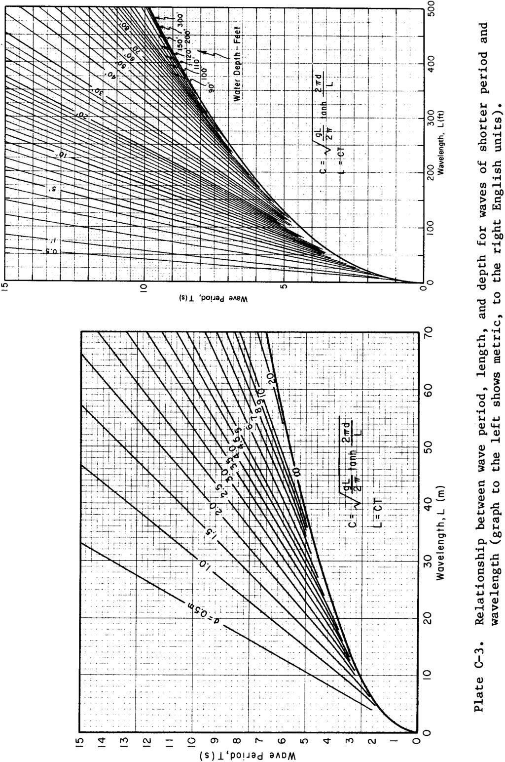
107 C-32
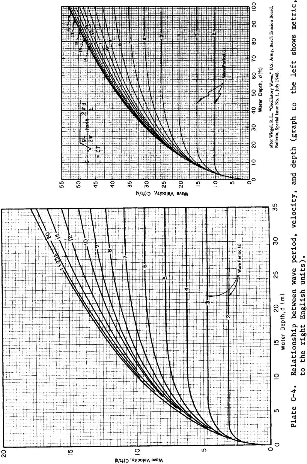
108 C-33
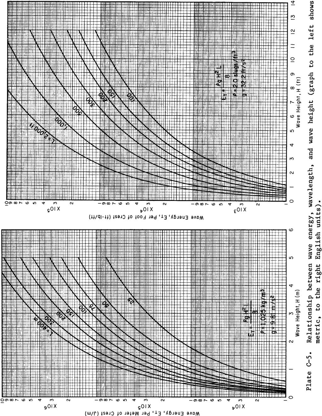
109 C-34
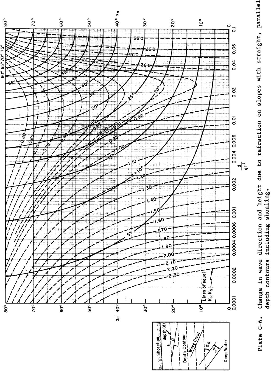
110 C-35
111 Table C-4. Conversion factors: English to metric (SI) units of measurement The following conversion factors adopted by the U.S. Department of Defense are those published by the American Society for Testing and Materials (ASTM) (Standard for Metric Practice, December 1979), except that additional derived conversion factors have been added. The metric units and conversion factors adopted by the ASTM are based on "International System of Units" (designated SI) which has been fixed by the International Committee for Weights and Measures. For most scientific and technical work it is generally accepted that the metric SI system of units is superior to all other systems of units. The SI is the most widely accepted and used language for scientific and technical data and specifications. In the SI system the unit of mass is the kilogram (kg) and the unit of force is the newton (N). N is defined as the force which, when applied to a mass of 1 kg, gives the mass an acceleration of 1 m/s 2. Former metric systems used kilogram-force as the force unit, and this has resulted in the conversion of pound-force to kilogram-force in many present-day situations, particularly in expressing the weight of a body. In the SI system the weight of a body is correctly expressed in newtons. When the value for weight is encountered expressed in kilograms, it is best to first convert it into newtons by multiplying kilograms by This provides consistent usage of the SI system, and will help to eliminate errors in derived units. 1 Exact conversion value. 2 Technically, mass-to-force conversion. C-36
112 Table C-4. Concluded. 1 Exact conversion value. 2 The SI unit for a newton per square meter is a pascal. 3 Technically, mass/area-to-force/area conversion. 4 Technically, density-to unit weight conversion. 5 The SI unit for a newton-meter is a joule. 6 The SI unit for a newton -meter per second is a watt. C-37
113 Table C-5. Phi-millimeter conversion table Table C-5 is reproduced from the Journal of Sedimentary Petrology, with the permission of the author and publisher. It was taken from the Harry G. Page, "Phi-Millimeter Conversion Table," published in Volume 25, pp , 1955, and includes that part of the table from (about 63 mm) to (about mm) which provides a sufficient range for beach sediments. The complete table extends from about (about 100 mm) to (about mm). The first column of the table shows the absolute value of phi. If it is positive, the corresponding diameter value is shown in the second column. If phi is negative, the corresponding diameter is shown in the third column of the table. In converting diameter values in millimeters to their phi equivalents, the closest phi value to the given diameter may be selected. It is seldom necessary to express phi to more than two decimal places. The conversion table is technically a table of negative logarithms to the base 2, from the defining equation of phi: φ = log 2 d, where d is the diameter in millimeters. Values of phi can also be determined with an electronic calculator having scientific notation by use of the following relationship: The table begins on the following page. C-38
114 Table C-5. Phi-millimeter conversion table C-39
115 Table C-5. Continued. C-40
116 Table C-5. Continued. C-41
117 Table C-5. Concluded. C-42
118 Table C-6. Values of slope angle φ and cot φ for various slopes. C-43

119 APPENDIX D Subject Index Mustang Island, Texas, 16 November 1972
120 SUBJECT INDEX - - A - - Absecon Inlet, New Jersey, 4-91, Active earth force, 7-256, 7-257, 7-259, Adak Island, Alaska, Adjustable groin, 1-24, 5-53 Adjusted shoreline (see Beach alinement) Airy, 2-2 Wave Theory, 2-2, 2-4, 2-25, 2-31 thru 2-33, 2-44, 2-46, 2-54, thru 7-106, thru 7-117, 7-135, 7-137, 7-139, 7-140, 7-142, thru Akmon, Algae, coralline (see Coralline algae) Alongshore transport (see Longshore transport) American beach grass, 6-44 thru 6-50, 6-52, 6-53 Amsterdam, The Netherlands, 6-92 Anaheim Bay, California, 4-91, 5-9 Analysis, sediment (see Sediment analysis) Anchorage, Alaska, 1-6, 3-91 Anemometer, 3-30, 3-33, 3-52 Angle of internal friction (see Internal friction angle) wall friction, 7-257, wave approach, 2-90, 2-91, 2-99, 2-116, 5-35, 7-198, 7-199, 7-201, Angular frequency (see Wave angular frequency) Annapolis, Maryland, 3-116, Antinode, 2-113, 2-114, 3-98, 3-99 Apalachicola, Florida, 3-92 Aransas Pass, Texas, Armor stone, 1-23, 2-119, 6-83, 7-210, 7-236, 7-243, 7-247, 7-249, thru units (see also Articulated armor unit revetment; Concrete armor units; Precast concrete armor units; Quarrystone armor units; Rubble-mound structure; Stone armor units; Stability coefficient), 2-119, 2-121, 2-122, 6-88, 7-3, 7-4, thru 7-225, 7-229, 7-231, thru 7-240, 7-242, 7-243, 7-249, 8-50, 8-51, 8-59, 8-60, 8-73 akmon (see Akmon) cube, modified (see Modified cube) dolos (see Dolos) hexapod (see Hexapod) hollow square (see Hollow square) tetrahedron (see Hollow tetrahedron) interlocking blocks (see Interlocking concrete block) porosity (see Porosity) quadripod (see Quadripod) stabit (see Stabit) svee block (see Svee block) tetrapod (see Tetrapod) toskane (see Toskane) tribar (see Tribar) types, weight, 7-206, 7-240, 7-249, 7-250, 8-48, 8-50, 8-62, 8-67 thru 8-69, 8-71 Articulated armor unit revetment, 6-6 Artificial beach nourishment (see also Protective beach), 1-19, 4-76, 5-6, 5-7, 5-24, 5-28, 5-34, 5-55, 5-56, 6-16 tracers (see also Flourescent tracers; Radioactive tracers), Asbury Park, New Jersey, 4-91, 6-83 Asphalt, 6-76, 6-83, 6-84, 7-139, groin, 6-83 Assateague, Virginia, 1-17, 4-37 Astoria, Oregon, Astronomical tides, 3-88, 3-89, 3-92, 3-104, 3-111, 3-119, 3-121, 3-123, 7-2, 7-81, 8-7, 8-10 thru 8-12, 8-46 Atchafalaya Bay, Louisiana, 3-92 Atlantic Beach, North Carolina, 4-91 City, New Jersey, 1-3, 1-9, 3-116, 3-124, 3-125, 4-11, 4-16, 4-31 thru 4-33, 4-37, 4-41, 4-77 thru 4-79, 4-180, 6-25 Intercoastal Waterway, 6-28 Atmospheric pressure (see also Central pressure index), 1-7, 2-21, 3-34, 3-35, 3-89, 3-96, 3-107, 3-110, 3-111, Attu Island, Alaska, Avalon, New Jersey, B-- Backfill, 7-256, 7-257, 7-260, 8-81 Backshore, 1-2, 1-13, 1-17, 1-20, 1-23, 3-105, 3-109, 4-62, 4-76, 4-83, 4-108, 4-115, 4-120, 4-127, 4-128, 5-20, 6-31, 6-37, protection, 3-105, 5-19 Bakers Haulover Inlet, Florida, 6-32 Bal Harbor, Florida, 6-32 Baltimore, Maryland, 3-116, 3-124, Bar (see also Inner bar; Longshore bar; Offshore bar; Outer bar; Spits; Swash bar), 1-8, 1-13 thru 1-15, 1-17, 2-124, 2-125, 4-80, 4-82, 4-83, thru 4-151, 5-6, 6-75, 7-14, A-49 Harbor, Maine, 3-116, 3-124, Barnegat Inlet, New Jersey, 4-91, 4-170, 6-25 Light, New Jersey, 4-77, 4-79 Barrier (see also Littoral barrier), 1-6, 1-22, 2-75, 2-109, thru 2-114, 3-122, 4-57, 4-136, 4-147, 4-154, 5-28, 5-31, 6-1, 6-72, 7-44, 7-232, beach, 1-8, 3-110, 4-24, 4-165, 5-56, 6-36 inlet effect on (see Inlet effect on barrier beaches) island, 1-8, 1-9, 1-13, 1-16, 1-17, 3-123, 4-1, 4-3, 4-5, 4-6, 4-22, 4-24, 4-45, thru 4-110, 4-112, 4-113, 4-115, 4-119, 4-120, 4-133, thru 4-142, 4-167, 4-177, 6-32 deflation plain (see Deflation plain) Barrow, Alaska, 4-45 Bathymetry (see also Nearshore bathymetry; Offshore bathymetry; Shelf bathymetry), 2-60, 2-62, 2-122, 3-24, 3-123, 4-75, 4-147, 4-151, 4-174, 5-1, 7-13, 7-14, 7-17, 7-202, 8-1 Battery, New York, 3-116, 3-124, 3-125, 4-77 Bay County, Florida, 4-77, 4-79 Bayou Riguad, Beach (see also Backshore; Berm; Deflation plain; Dune; Feeder beach; Pocket beach; Protective beach), 1-2 thru 1-4, 1-7, 1-9, 1-10, 1-12, 1-13, 1-19, 2-1, 2-112, 2-118, 3-100, 3-101, 4-108, 5-6, 5-30, 5-55, 5-56, 6-37, A-47, A-49 alinement, 1-14, 1-17, 5-1, 5-40 thru 5-46, 5-48 thru 5-50, 5-52, 5-54, 5-73, 8-32, 8-86 changes, 4-6, 4-23, 4-30, 4-45, 4-46, 4-77, 4-78, 4-108, 4-110, 4-126, 4-143, 6-26, 6-27 long-term, 4-6, 5-5 short-term, 4-6, 5-4 characteristics, 1-7, 4-79 composition, 2-1 erosion, 1-10, 1-13, 1-16, 1-23, 3-110, 4-76, 4-80, 4-83, 4-85, 4-89, 4-110, 4-114, 4-117, 4-129, 4-134, 4-148, 5-6, 6-16, 6-54, 6-61, 6-72 rate, 4-110, D-1
121 SUBJECT INDEX Beach (Cont) face (see also Shoreface), 1-17, 4-1, 4-6, 4-27, 4-50, 4-59, 4-76, 4-83, 4-108, 5-9 fill (see also Artificial beach nourishment), 1-19, 4-12, 4-15, 4-58, 4-60, 4-80, 4-119, 4-121, 4-143, 5-4, 5-5, 5-8 thru 5-10, 5-13, 5-15, 5-19 thru 5-23, 5-71, 6-15, 6-16, 6-26, 6-28, 6-31, 6-32, 6-35, 6-36, 6-95, 8-90 erosion, 6-26 slopes, 5-21, 5-22 grasses (see also American beach grass; European beach grass; Panic grasses; Sea oats), 4-5, 4-108, 6-38, 6-44, 6-46 thru 6-48, 6-52, 6-53 planting summary, 6-47 seeding, 6-47 transplanting, 6-46 Haven, New Jersey, 4-9 nourishment (see also Artificial beach nourishment), 1-16, 1-19, 4-71, 4-173, 4-180, 5-22, 5-24, 5-34, 5-39, 5-73, 5-74, 6-14, 6-26, 6-32, 6-75 offshore bar (see Offshore bar) profile (see also Profile accuracy), 1-2, 1-9, 1-10, 1-16, 1-17, 4-1, 4-2, 4-5, 4-6, 4-27, 4-43, 4-45, 4-58, 4-60 thru 4-64, 4-76, 4-80, 4-86, 4-89, 4-117, 4-143, 4-147, 5-3, 5-4, 5-6, 5-8, 5-19, 5-20, 5-31, 5-35, 5-40, 5-43, 5-48 thru 5-51, 5-67, 6-26 terms, A-42 protection (see also Artificial beach nourishment; Beach grasses; Beach nourishment; Beach restoration; Shore protection), 1-8, 1-10, 4-23, 4-119, 6-75 vegetation (see Beach grasses; Vegetation) recovery, 1-13, 4-76, 4-78, 4-80, 4-83 replenishment, 4-119, thru 4-129, 4-134, 5-6, 5-21, 6-30 response, 1-9 thru 1-11, 1-15 restoration (see also Artificial beach nourishment; Beach nourishment; Dune), 1-19, 1-22, 5-6, 5-7, 5-20, 5-23, 6-15, 6-15, 6-25, 6-28, 6-34 rock, 4-23, 4-24 sediment, 1-7, 1-13, 1-16, 2-60, 4-12, 4-15, 4-23, 4-27, 4-85, 5-12, 5-13, 5-21, C-38 slopes, 1-7 thru 1-9, 1-14, 2-129, 2-130, 2-135, 3-102, 3-105, 3-107, 4-44, 4-49, 4-54, 4-83, 4-87, 4-88, 5-20, 5-35, 5-49, 5-50, 5-64, 5-67, 5-71, 7-8, 7-194, 7-196, stability, 1-15, 5-56, 6-54 storm effects (see Storm attack on beaches) surveys, Beacon Inn, California, 4-10 Beaumont, Texas, 3-112, Bedding layer, 7-227, 7-228, thru 7-242, 7-245, thru Bedload (see also Suspended load), 4-58, 4-59, 4-65, 4-66, Belfast, Maine, 3-92 Berm (see also Storm berm; Toe berm), 1-2, 1-3, 1-10, 1-12, 1-17, 3-100, 4-1, 4-10, 4-21, 4-62, 4-67, 4-80, 4-83, 4-108, 4-117, 4-120, 4-148, 5-5, 5-6, 5-20 thru 5-22, 5-24 thru 5-26, 5-28, 5-40, 5-41, 5-43 thru 5-46, 5-49 thru 5-53, 5-60, 6-26, 6-32, 6-39,6-46, 6-84, 7-35 thru 7-40, elevation, 1-7, 1-10, 4-76, 4-79, 4-86, 5-8, 5-20, 5-45, 5-50, 7-37 width, 1-7, 1-10, 5-20 thru 5-22, 5-45, Biloxi, Mississippi, 4-35 Biscayne Bay, Florida, 6-36 Boca Grande Inlet, Florida, Raton, Florida, 4-37 Inlet, 6-61 Bodie Island, North Carolina, 4-77, 4-79 Borrow areas, 4-119, 4-173, 5-10, 5-12, 5-19, 6-14 thru 6-16, 6-28, 6-36, 6-75 Borrow (Cont) material, 5-6, 5-8 thru 5-13, 5-16, 5-17, 5-19, 5-21, 6-16, 6-26, 8-90, 8-91 selection, 5-8, 5-9 Boston, Massachusetts, 3-90, 3-116, 3-124, 3-125, 4-35, 4-77 Harbor, Bottom friction, 2-2, 2-63, 3-55, 3-66 thru 3-68, 3-70, 3-75, 4-29, 4-30, 4-36, 4-124, 7-13, 7-14, 8-90 factor, 3-24, 3-67, 3-68 profile, 7-2, 8-5, 8-6 slopes, 2-6, 2-109, 2-126, 4-85, 7-16, 7-182, 7-237, topography, 2-60, 2-62, 2-66, 2-74, 4-29, 4-31, 7-14 velocity, 1-10, 4-47, 4-49, 4-67 thru 4-69, 4-73, 5-37 Breaker (see Breaking wave) Breaking wave (see also Design breaking wave), 1-1, 1-2, 1-9, 1-14, 2-37, 2-73, 2-129, 2-130, 2-133, 2-134, 3-12, 3-15, 3-99, 3-105, 4-4, 4-49, 4-50, 4-53, 4-55, 4-57 thru 4-60, 4-67, 4-100, 4-107, 4-142, 4-143, 4-147, 5-3, 5-5, 5-63, 5-65, 6-88, 7-2 thru 7-4, 7-8, 7-11, 7-14, 7-17, 7-18, 7-38, 7-40, 7-45 thru 7-53, 7-100, 7-117, thru 7-126, thru 7-161, thru 7-170, 7-180, 7-182, 7-191, 7-192, 7-198, thru 7-204, 7-206, 7-207, 7-209, 7-212, 7-238, 7-246, 8-35 depth, 2-59, 2-130, 5-39, 7-37, 7-193, forces (see also Minikin), thru 7-160, 7-170, 7-181, on piles, 7-100, on walls, 7-100, 7-180, 7-182, geometry, 7-5 height (see also Design breaking wave height), 2-37, 2-119, 2-121, 2-130, 2-135, 2-136, 3-15, 3-102, 3-104, 4-4, 4-22, 4-51, 4-54, 4-92, 4-98, 4-100, thru 4-106, 7-4, 7-5, 7-8, 7-9, 7-11, 7-13, 7-112, 7-117, 7-118, 7-159, 7-181, 7-183, 7-186, 7-187, 7-192, 7-193, index, 2-130, 2-131, 4-104, 7-7, 7-12 types, 1-9, 2-130, thru 2-135, 4-49, A-44 Breakwater (see also Cellular-steel sheet-pile breakwater; Composite breakwater; Concrete caisson breakwater; Floating breakwater; Impermeable breakwater; Offshore breakwater; Permeable breakwater; Rubblemound breakwater; Shore-connected breakwater; Steel sheet-pile breakwater; Stone-asphalt breakwater; Subaerial breakwater; Submerged breakwater), 1-5, 1-19, 1-22, 1-23, 2-75, 2-76, 2-90 thru 2-100, 2-109, 2-110, 2-115, 2-116, 2-119, 3-110, 5-28, 5-59, 5-64 thru 5-72, 6-1, 6-54, 6-59, 6-73, 7-1, 7-3, 7-61, 7-62, 7-64, 7-66, 7-67, 7-73 thru 7-75, 7-81 thru 7-85, 7-89, 7-92 thru 7-94, 7-100, 7-180, 7-181, 7-187, 7-198, 7-203, 7-207, 7-211, 7-225, 7-226, 7-229, 7-233, 7-236, 7-238, 7-239, 7-242, 7-246, 8-74, 8-75, 8-81 gaps, 2-92, 2-93, 2-99 thru 2-103, 2-107, 2-108, 5-64, 5-65, 5-67, 5-72, 5-73, 6-95, 7-89, 7-94 thru 7-98 Harbor, Delaware, 3-116, 3-124, Brigantine, New Jersey, 4-37 Broken wave, 1-3, 1-9, 4-59, 7-2, 7-3, 7-16, 7-17, 7-100, 7-160, 7-161, 7-170, 7-192, 7-193, 7-195, 7-198, 7-200, 7-202, Broward County, Florida, 6-74 Brown Cedar Cut, Texas, 4-167, Brownsville, Texas, Brunswick County, North Carolina, 5-15 Buffalo Harbor, Lake Michigan, Bulkhead (see also Cellular-steel sheet-pile bulkhead; Concrete bulkhead; Sheet-pile bulkhead; Steel sheetpile bulkhead; Timber sheet-pile bulkhead), 1-19 thru 1-21, 2-112, 2-126, 5-2 thru 5-4, 6-1, 6-6, 6-7, 6-14, 6-56, 6-73, 7-100, 7-198, 7-249, D-2
122 SUBJECT INDEX Burrwood, Louisiana, 3-81 Bypassing sand (see Sand bypassing) - - C - - Caisson (see also Cellular-steel caisson; Concrete caisson; Nonbreaking wave forces on caissons), 5-56, 6-93, 7-105, 7-182, 8-75, 8-77, 8-81, 8-84 stability, 8-75, 8-81 Calcais, Maine, 3-92 Camp Pendleton, California, 4-91 Cantilever steel sheet-pile groin, 6-79, 6-83 Canyon (see also Submarine canyon), Cape Canaveral, Florida, 6-15, 6-25 Cod, Massachusetts, 1-11, 3-110, 3-126, 4-24, 4-37, 4-44, 4-77, 4-79, 4-80, 4-110, 4-112, 6-38, 6-52 Fear North Carolina, 6-15, 6-16 River, 5-19, 6-22, 6-28 Hatteras, North Carolina, 4-35, 4-112, 4-120, 4-153, 8-86 Henlopen, Delaware, Henry, Virginia, 3-92 Lookout, North Carolina, National Seashores, May, New Jersey, 3-92, 4-80, 5-54, 6-15, 8-28, 8-86 Mendocino, California, 3-92 Sable, Florida, 4-24 Romano, Florida, 4-24 Capillary wave, 2-5, 2-24 Carbonate loss, 4-124, 4-127, production, 4-119, thru Camel Beach, California, 4-10 Carolina Beach, North Carolina, 5-21, 5-22, 6-16, 6-21, 6-22, 6-25 thru 6-28 Inlet, 6-16, 6-28 Carteret, New Jersey, 3-123, Casagrande size classification, 4-12 Cathodic protection, 6-88 Caustic, 2-74 Caven Point, New York, 3-124, Cedar Key, Florida, Cedarhurst, Maryland, 6-13 Celerity (see Wave celerity) Cellular-steel caisson, 6-88 sheet-pile breakwater, 5-61, 6-91 thru 6-93 bulkhead, 6-6 groin, 6-80, 6-83, 6-84 jetty, 6-87 structures, 6-88, 6-92 Central pressure index, 3-110, Channel (see also Navigation channel), 1-24, 3-122, thru 4-157, 4-161, 4-162, 4-164, 4-165, 4-177, 5-2, 5-26, 5-28, 5-56 thru 5-58, 6-56, 6-58 thru 6-60, 6-73, 6-74, 7-233, 7-250, 7-251, Islands Harbor, California (Port Hueneme), 1-23, 2-77, 4-37, 4-90, 5-61, 5-62, 6-61, 6-64, 6-72 revetment stability, shoaling, 1-24, 4-177, 4-180, 5-56, 5-58 Charleston, South Carolina, 3-92, 3-117, 3-124, 3-125, 4-35 Chatham, Massachusetts, 3-92, Chesapeake Bay Bridge Tunnel, Virginia, 3-3 Maryland, 4-22, 4-141, 6-11, 6-15 Clapotis (see also Seiche; Standing wave), 2-3, 2-113, 2-114, thru 7-163, thru 7-174, 7-177, 7-178, Clatsop Plains, Oregon, 6-52 Spit, Oregon, 4-110, 6-52 Clay, 1-7, 4-12, 4-13, 4-17, 4-18, 4-21, 4-22, 4-24, 4-115, 7-258, Cleveland Harbor, Ohio, Cliff erosion, 1-17, 4-45, 4-114, 4-115, 4-117, thru Cnoidal wave, 2-44 thru 2-48, 2-54, 2-57, 2-58, theory, 2-2, 2-3, 2-31, 2-33, 2-44, 2-46, 2-54, 7-54, 7-55 Coast, 1-2 Coastal engineering (see also Planning analysis), 1-1, 1-2, 1-4, 4-64, 5-1 erosion (see Shoreline erosion) profile, 4-60 structures, 1-2, 1-17, 2-1, 3-126, 4-58, 4-74, 7-1, 7-58, 7-100, 7-241, Cobble, 1-7, 4-12, 4-13 Coefficient (see Drag coefficient; Diffraction coefficient; Energy coefficient; Expansion of ice coefficient; Friction coefficient; Hydrodynamic force coefficient; Inertia coefficient; Isbash coefficient; Layer coefficient; Lift coefficient; Mass coefficient; Overtopping coefficient; Reflection coefficient; Refraction coefficient; Refraction-diffraction coefficient; Shoaling coefficient; Stability coefficient; Steady flow drag coefficient; Transmission coefficient) Cohesionless soil, Cohesive material (see also Clay; Peat; Silt), 4-21 Cohesive soil, Cold Spring Inlet, New Jersey, 4-90, 4-91 Columbia River, Washington, 3-92 Complex wave, 2-2 thru 2-4 Composite breakwater, 7-182, slopes, 7-35 thru 7-37, 7-40 Computer programs, 2-71, 3-89, 5-44, 7-82, 7-88 Concrete (see also Interlocking concrete block; Unit weight--concrete), 1-23, 1-24, 5-2, 5-56, 6-1 thru 6-4, 6-6, 6-7, 6-10, 6-14, 6-76, 6-81, 6-83, 6-84, 6-95, 6-96, 6-98, 7-213, 7-214, 7-235, 7-236, 7-242, 7-249, 7-260, 8-47, 8-51, 8-54, 8-65, 8-69, 8-71, 8-73, 8-79 armor unit, 5-61, 6-88, 7-32, 7-202, 7-210, thru 7-215, thru 7-227, 7-231, 7-233, 7-235, 7-236, 7-239, 7-240, 8-47, 8-68 bulkhead, 6-6, 6-7 caisson, 5-59, 5-61, 6-88, 6-93 breakwater, 6-93 cap, 5-59, 6-12, 6-82, 6-89, 7-208, 7-229, 7-235, 7-236, groin, 6-83, 6-84 pile, 1-20, 6-88 revetment, 6-6, 6-10 sheet-pile, 6-74, 6-75, 6-84, 6-88 groin, 6-81, 6-84 Consolidated material (see also Beach rock; Coral; Rock), 4-23 Construction, 6-95, 6-97 design practices, 6-95, 6-97 materials, 6-95 Continental shelf (see also Shelf bathymetry; Shelf profile), 3-122, 3-123, 4-17, 4-61, 4-65, 4-70, 4-71, 4-93, 4-117, 4-147, 6-15, 7-14 Convergence, 2-74 Conversion factors: English to metric, C-36 Coos Bay, Oregon, 4-37 Coquille River, Oregon, 4-37 Coquina, 4-24 D-3
123 SUBJECT INDEX Coral, 4-17, 4-22, 4-23, Coralline algae, 4-23 Core Banks, North Carolina, 4-108, 6-38, 6-49, 6-50, 6-53 Coriolis, 3-24, effects, 2-6, force, 2-5, 3-24 parameter, 3-34, 3-38, 3-82, 3-84, Corpus Christi, Texas, thru 3-114, 4-37, 6-16 thru 6-18, 6-25 Corrosion, 6-88, 6-92, 6-96, 7-139, 7-149, Coulomb equation, Cover layer, 7-202, 7-205, 7-207, 7-211, thru 7-229, 7-233, thru 7-240, 7-242, thru 7-249, 8-48, 8-49, 8-51, 8-58 thru 8-61, 8-69, 8-71 design, stability, 7-238, thickness, 8-48, 8-58, 8-59, 8-62, 8-74 Crane Beach, Massachusetts, 4-82, 4-83 Crescent City, California, 3-118, 6-89, 6-92, Crest, wave (see Wave crest) Crib, 5-56, 5-59, 5-61, 5-62, 6-6, 6-14, 6-59, Cube, modified (see Modified cube) Current (see also Density currents; Inlet currents; Littoral currents; Longshore current; Nearshore currents; Onshore-offshore currents; Rip currents; Salinity currents; Tidal currents), 1-3, 1-4, 1-6, 1-7, 1-13, 2-60, 2-62, 4-1, 4-4, 4-5, 4-12, 4-23, 4-48, 4-49, 4-55, 4-57, 4-58, 4-89, 4-105, 4-126, 4-147, 4-150, 4-157, 4-159, 4-177, 5-1, 5-2, 5-9, 5-21, 5-22, 5-35, 5-56, 5-57, 5-65, 5-73, 6-1, 6-56, 6-73, 7-241, thru 7-247, 7-254, 8-1, 8-7 velocity (see also Longshore current velocity), 3-119, 3-121, 7-241, 7-246, 7-247, 7-249, 7-250, 8-12 Cuspate spit, 5-61, 5-63 thru 5-67, 5-69, 5-71 Cuttyhank, Massachusetts, 3-92 Cylinders, 7-102, Cylindrical pile, 7-138, D - - d/l--tables of Functions, 2-64, C-5, C-17 Dade County, Florida, 1-19, 1-22, 5-20, 6-16, 6-25, 6-32 thru 6-34, 6-36 Dams, 1-17, Datum plane, 3-92 Daytona Beach, Florida, 1-8, 4-35, 4-37, 6-71 Decay, wave (see Wave decay) Deep water, 1-3, 1-5, 2-9, 2-15, 2-18, 2-20, 2-24 thru 2-28, 2-30 thru 2-32, 2-35, 2-37, 2-60, 2-62 thru 2-64, 2-66, 2-68, 2-70, 2-71, 2-74, 2-129, 3-11, 3-15, 3-18, 3-24, 3-39, 3-55, 3-77, 3-101, 4-29, 4-30, 4-95, 4-105, 4-107, 4-123, 4-124, 4-129, 6-92, 7-1, 7-2, 7-13, 7-15, 7-33, 7-63, 7-117, thru 7-126, 7-157, 7-164, 7-167, 7-183, 8-26, 8-33, 8-34, C-3, C-35 significant wave height, 3-49, 3-50, 3-83 thru 3-86, 3-101, 3-105, 3-107, 4-85, 4-93, 4-99, 7-1, 7-15, 7-59, wave, 2-10, 2-11, 2-17, 2-66, 3-2, 3-21, 3-24, 3-45, 3-46, 3-55 thru 3-66, 4-36, 4-46, 4-85, 4-94, 7-3, 7-7, 7-11, 7-14, 7-89, 7-110, 7-146, 8-26, 8-33, 8-36, 8-44, 8-85, 8-87 thru 8-89 forecasting equation, 3-48 height, 2-20, 2-64, 2-130, 2-135, 3-104, 3-107, 4-102, 7-5, 7-11, 7-13, 7-14, 7-16, 7-33, 7-35, 7-44, 7-54, 8-33 length, 2-130, 7-4, 7-93, 7-94, 8-34, C-3, C-30 prediction, 3-44, 3-49, 3-50, 3-66 Deflation, 1-16, 4-5, 4-124, 4-127, 4-128, 5-9 plain, 4-108, 4-109, Del Mar, California, 4-10, Delaware Bay, 4-140, 8-1, 8-7 thru 8-9, 8-12 thru 8-14, 8-17, 8-21, 8-22, 8-25, 8-26, 8-31, 8-32, 8-74 Delray Beach, Florida, 6-25 Density (see also Energy density; Mass density), 2-6, 3-6, 3-33, 3-121, 4-18, 4-50, 7-127, 7-236, currents, 4-49, Design, 7-149, 7-232, 8-1 analysis, 5-73, 5-74, 7-3 breaking wave, 7-11, 7-13, height, 7-4, 7-8 thru 7-10, 7-13, 7-14, hurricane, 8-7 practices (see Construction design practices) profile, 6-26 storm, 3-115, 3-126, water level, 3-123, 3-126, 7-2, 7-3, 7-15, 7-16, 7-247, 7-260, 8-12 wave, 3-104, 5-5, 5-58, 6-83, 7-3, 7-4, 7-9, 7-14, 7-15, 7-17, 7-33, 7-35, 7-37, 7-105, 7-106, 7-112, 7-127, 7-129, 7-133, 7-140, 7-146, 7-149, 7-150, thru 7-155, 7-173, 7-203, 7-208, 7-212, 7-243, 8-46, 8-47 conditions, 7-3, 7-16, thru 7-204, 7-211, 8-25 height, 7-3, 7-4, 7-15, 7-118, 7-127, 7-133, 7-146, 7-203, 7-205, 7-207, 7-208, 7-211, 7-212, 7-237, 7-242, 7-243, 7-246, 7-247, 7-249, 8-46, 8-49 period, 5-5, 7-3, 7-127, 7-133, Destin, Florida, 4-37 Diablo Canyon, California, Diffraction coefficient (see also Wave diffraction), 2-77, 2-92 thru 2-98, thru 2-107, 2-110, 7-89, 7-93, 7-94, 7-99 Dispersive medium, 2-25 wave, 2-25, 2-56 Diurnal tide, 3-89, 3-92 Divergence, 2-74 Doheny Beach State Park, California, 6-79, 6-81 Street Beach, California, 6-25 Dolos, 6-86, 6-88, 7-75, 7-206, thru 7-212, thru 7-217, 7-221, 7-225, 7-226, 7-231, 7-234, thru Drag coefficient (see also Steady flow drag coefficient), 3-30, 7-101, 7-103, 7-133, thru 7-139, 7-144, forces, 7-106, 7-109, 7-116, 7-132, 7-133, 7-136, 7-138, 7-145, 7-146, 7-155, Drakes Bay, California, Dredges (see also Floating dredges; Hopper dredges; Pipeline dredges; Split-hull dredges), 5-32, 5-33, 6-14, 6-31, 6-36 Dredging (see also Land-based vehicles; Side-cast dredging), 1-17, 1-24, 1-26, 4-105, 4-117, 4-119, 4-124, thru 4-129, 4-134, 4-176, 4-177, 4-179, 4-180, 5-28, 5-30, 5-31, 5-58, 5-73, 5-74, 6-30, 6-35, 6-36, 6-54, 6-72 thru 6-75 plant (see also Land-based dredging plant), 5-19, 5-30 discharge line, 5-31, 5-33 Drift, littoral (see Littoral drift) Drum Inlet, North Carolina, 4-120, 4-121, 4-143, 4-153, Duck, North Carolina, 4-77, 4-80, 4-81 Dune (see also Foredune), 1-8 thru 1-13, 1-16, 1-17, 1-19, 1-21, 1-25, 1-26, 3-71, 3-105, 3-106, 4-1, 4-5, 4-27, 4-44, 4-46, 4-76, 4-78, 4-83, 4-108, 4-110, 4-117, 4-118, 4-120, 4-127, 4-128, 5-24 thru 5-27, 6-1, 6-26, 6-37 thru 6-43, 6-48 thru 6-53 construction, 5-26, 6-43, 6-53 using sand fencing, 4-110, 6-38, 6-39 vegetation, 4-110, 6-43 formation, 4-5, 6-38, 6-48 D-4
124 SUBJECT INDEX Dune (Cont) migration, 4-124, 4-125, 5-24, 5-25 profile, 6-48, 6-51 stabilization, 5-24, 5-25, 6-38, 6-43, 6-44 trapping capacity, 6-41, 6-43, 6-51, 6-53 Duration, wind (see Wind duration) Durban, Natal, South Africa, 6-54 Dutch Harbor, Unalaska Island, Alaska, 3-91, toe, 7-247, Duval County, Florida, 6-25 Dynamic forces, 7-161, 7-180, 7-182, 7-187, 7-193, 7-197, pressure, thru 7-195, E - - Earth forces (see also Active earth force; Hydrostatic forces; Passive earth force), 6-76, 7-256, 7-259, 7-260, 8-83 pressure, 8-82 Earthquakes, 1-7, 2-56, 3-89, 3-92, 3-93, 7-1 East Pass, Florida, 4-179, 4-180, 6-61, 6-70 Eastport, Maine, 1-6, 3-116, 3-124, 3-125, 4-35 Ebb-tidal delta, thru 4-152, 4-154, 4-155, 4-157, 4-160, 4-167, 4-173, 4-174, 4-177, Echo sounder, 4-62 Ecological considerations, 5-73 Eddy shedding (see also Lift forces), Ediz Hook, Port Angeles, Washington, 6-25 El Segundo, California, 4-91 Energy (see also Kinetic energy; Longshore energy; Potential energy; Wave energy; Wind energy), 2-5, 3-5, 3-11, 3-12, 3-14, 3-15, 3-20, 3-21, 3-79, 5-3, 5-65, 5-67, 5-69, 5-71, 7-2, coefficient, C-4 density, 2-26, 3-11, 3-12, 3-14, 4-95, 7-67, 7-89, 7-93, 7-94, 7-99, flux (see also Longshore energy flux factor), 2-26 thru 2-28, 2-109, 4-54, 4-92, 4-93, 4-96, 4-101, 4-147, 5-69, 8-89, 8-90 Engineering, coastal (see Coastal engineering) Englishman Bay, Maine, 3-92 Environmental considerations, 5-19, 5-74 Equilibrium geometry, Erosion (see also Beach erosion; Beach fill erosion; Cliff erosion; Longshore transport; Shoreline erosion), 1-1, 1-3, 1-7, 1-12 thru 1-17, 1-19 thru 1-21, 1-24 thru 1-26, 2-60, 2-126, 4-1, 4-10, 4-44, 4-57, 4-60, 4-65, 4-77, 4-78, 4-80, 4-83, 4-85, 4-91, 4-113, thru 4-118, 4-124, 4-131, 4-172, 4-173, 5-2, 5-4 thru 5-7, 5-24, 5-26, 5-28, 5-35, 5-43, 5-52, 5-53, 5-55, 5-56, 5-58, 5-60, 5-64, 6-1, 6-26, 6-27, 6-32, 6-46, 6-53, 6-54, 6-73, 6-95, 7-233, 7-241, 7-242, rate (see also Beach erosion rate), 1-17, 4-6, 4-129, 4-133, 4-147, 5-22, 5-23, 6-51 Estuary, 1-2, 1-3, 1-7, 1-13, 1-26, 3-1, 3-107, 3-109, 3-115, 3-123, 4-5, 4-49, 4-117, 4-148, 4-166, 5-57 Eugene Island, Louisiana, European beach grass, 4-110, 6-44, 6-45, 6-47, 6-52, 6-53 Evanston, Illinois, 4-91 Expansion of ice coefficient, Extratropical storm, 3-11, 3-110, 3-119, 3-123, Extreme events (see also Hurricane; Storm; Tsunami), 4-43, 4-44, 4-76, 7-2, 7-3, 7-242, F - - Fall velocity, 4-18 thru 4-21, 4-28, 4-85 Fan diagrams (see Wave refraction analysis--fan diagrams) Father Point, Quebec, 3-95, 3-96 Feeder beach, 5-8, 5-23, 5-24, 6-72, 6-73 Feldspar, 4-21, 4-22 Fernandina, Florida, Beach, 6-5, 6-82 Fetch, 1-6, 1-7, 1-13, 3-24, 3-33, 3-35, 3-36, 3-39, 3-41 thru 3-44, 3-47, 3-48, 3-51 thru 3-65, 3-67, 3-70 thru 3-72, 3-74, 3-76, 3-127, 4-29, 7-17, 7-161, 8-12, 8-17 delineation, 3-39 length, 3-42, 3-49 thru 3-51, 3-66 thru 3-68, 3-70, 3-71, 3-84, 7-1 width, 3-41 Filter blanket (see also Bedding layer), 7-229, thru 7-242, 7-245, Finite amplitude wave, 7-142, 7-154, theory (see also Trochoidal Wave Theory; Stokes Theory), 2-2, 2-4, 2-6, 2-7, 2-34, 2-35, 7-108, 7-112, 7-137, element models, Fire Island Inlet, New York, 4-37, 4-142, 6-25, 6-61, 6-66 First-Order Wave Theory (see Airy Wave Theory) Fixed bypassing plant, 5-31, 6-53, 6-56 thru 6-58, 6-60 Lake Worth Inlet, Florida, 6-54, 6-56, 6-58 Rundee Inlet, Virginia Beach, Virginia, 6-54, 6-56, 6-60 South Lake Worth Inlet, Florida, 6-54, 6-57 groin, 1-24, 5-53 Flexible revetment (see Articulated armor unit revetment) structures, 6-6, 6-14, 7-3 Floating breakwater, 5-59, 6-93 bypassing plant, 5-28, 5-30, 6-54, 6-59 Channel Islands Harbor, California, 6-61, 6-64, 6-72 Hillsboro Inlet, Florida, 6-61, 6-67, 6-74 Jupiter Inlet, Florida, 6-59, 6-62, 6-72 Masonboro Inlet, North Carolina, 6-61, 6-68, 6-74 Perdido Pass, Alabama, 6-61, 6-69, 6-75 Ponce de Leon Inlet, Florida, 6-61, 6-71 Port Hueneme, California, 6-59, 6-61, 6-72 Santa Barbara, California, 6-61, 6-65, 6-73 Sebastian Inlet, Florida, 6-63, 6-73 dredges, 1-23, 5-30, 5-32, 5-33, 6-14, 6-59, 6-61, 6-72, 6-73, 6-93 Flood-tidal delta, 4-152, 4-174, Flourescent tracers, 4-144, Fluid motion, 2-2, 2-3, 2-15, 4-19, 4-49, 4-58, 7-132, velocity, 2-12 thru 2-14, 2-45, 2-58, 4-18, 4-67, 7-101, Force (see also Active earth force; Drag forces; Dynamic forces; Earth forces; Eddy shedding; Horizontal forces; Hydrostatic forces; Ice forces; Impact forces; Inertia forces; Lift forces; Passive earth force; Transverse forces; Uplift forces; Velocity forces; Wave forces), 1-4, 1-6, 1-7, 1-19, 1-21, 2-1, 2-60, 3-88, 3-89, 3-98, 7-1, 7-3, 7-101, 7-102, 7-105, thru 7-112, 7-118, 7-128, 7-129, 7-131, 7-138, 7-144, 7-149, 7-150, thru 7-161, 7-163, 7-170, 7-172, 7-173, thru 7-178, thru 7-182, 7-184, 7-186, 7-192, thru 7-198, 7-200, 7-202, 7-245, 7-253, thru 7-257, 7-260, 8-77, 8-80, 8-81, 8-83, 8-84 calculations, 7-143, D-5
125 SUBJECT INDEX Forecasting (see also Deep water wave prediction; Hurricane wave prediction; Shallow water wave prediction; Wave hindcasting; Wave prediction), 3-1, 3-34, 3-55 curves, 3-45, 3-46, 3-55 thru 3-66 Foredune, 1-12, 4-5, 4-62, thru 4-110, 4-112, 5-24, 5-26, 5-27, 6-37 thru 6-39, 6-45, 6-51 destruction, 6-38 Forerunner (water level), Foreshore, 1-2, 1-3, 1-8, 1-10, 1-21, 4-62, 4-72, 4-76, 4-83, 4-86, 5-31, 5-35, 5-37, 5-40, 6-75, 6-76 slopes, 4-86 thru 4-88, 4-148, 5-8, 5-21, 6-16, 6-27 Fort Hamilton, New York, 3-124, Macon State Park, North Carolina, 6-25 Myers, Florida, 4-35 Pierce, Florida, 6-15, 6-25 Point, Texas, Pulaski, Georgia, Sheridan, Illinois, Foundation (see also Pile foundation; Rubble foundation; Rubble-mound foundation), 1-23, 6-6, 6-84, 6-88, 6-92, 6-93, 7-177, 7-179, 7-241, 7-242, 7-244, conditions, 6-13, 6-14, 6-93, 7-240, 8-85 design, 5-73, materials, 6-14, 6-84, 6-93, 7-241, soil, 7-241, 7-242, 7-245, 8-75 stability, 7-229, Freeport, Texas, Frequency, wave (see Wave frequency) Friction (see also Angle of wall friction; Bottom friction; Internal friction angle), 3-20, 3-34, 3-74, 3-75, 3-98, 4-30, 8-33 coefficient, 4-55, 4-162, 7-260, 8-84 factor, 3-68, 3-72, 4-100, loss, 3-55, 3-69 velocity, 3-25, 3-26 Friday Harbor, Washington, Fully arisen sea, 3-24, 3-42, 3-49, 3-50, 3-53, G - - Gabions, 1-20, 7-242, Galveston, Texas, 3-90, 3-111, 3-112, 3-114, 3-117, 4-35, 4-37, 4-41, 6-2, 6-15 Harbor, Gay Head, Marthas Vineyard, Massachusetts, 4-23 Geostrophic wind, 3-25, 3-34, 3-35, 3-38, 3-40 Geotextile, 6-97, 7-241, 7-242, filter, 6-1, 6-6, 6-13, 6-14, 7-241, 7-242, 7-247, Gerstner, 2-2 Glossary of terms, A-1 thru A-40 Goleta Beach, California, 4-10 Government Cut, Florida, 6-32, 6-35 Gradient wind, 3-34 Grain size (see also Median grain size), 1-16, 4-12 thru 4-14, 4-18, 4-26, 4-66, 4-67, 4-71, 4-83, 4-85 thru 4-88, 4-145, 4-148, 4-180, 5-9 thru 5-12, 5-15, 5-19, 5-64, 5-67, 6-16, 6-26, 6-36, 6-39, A-41 Grand Isle, Louisiana, Marais, Michigan, 6-87 Graphic measures, 4-15 Grasses, beach (see Beach grasses) Gravel, 4-12, 4-13, 4-21, 4-124, 6-6, 7-241, 7-242, 7-258, Gravity wave, 2-4, 2-5, 2-9, 2-25, 2-31, 2-37, 3-88, 3-92, Great Lakes, 1-13, 1-14, 3-19, 3-21, 3-23, 3-30, 3-32, 3-96, 3-99, 3-127, 4-78, 4-91, 5-21, 5-39, 5-56, 5-59, 6-83, 6-92, 6-93, 7-253, 8-26 Greyhound Rock, California, 4-136, Groin (see also Adjustable groin; Asphalt groin; Cantilever sheet-pile groin; Cellular-steel sheet-pile groin; Concrete groin; Concrete sheet-pile groin; Fixed groin; High groin; Impermeable groin; Low groin; Permeable groin; Rubble-mound groin; Sheet pile groin; Steel groin; Steel sheet-pile groin; Terminal groin; Timber groin; Timber sheet-pile groin; Timber-steel sheet-pile groin; Transitional groin; Weir groin), 1-17, 1-19, 1-23, 1-24, 2-109, 3-110, 4-6, 4-58, 4-60, 4-76, 4-136, 4-139, 5-7, 5-22, 5-24, 5-32, 5-35 thru 5-56, 5-62, 6-1, 6-27, 6-56, 6-65, 6-76,6-83, 6-84, 7-1 thru 7-3, 7-100, 7-198, 7-204, 7-239, alinement (see also Beach alinement), 5-53 artificial filling, 5-7, 5-52, 5-54 construction, 4-6, 5-7, 5-39, 5-41, 5-52, 5-54 thru 5-56, 6-83 definition, 1-23, 5-35 design, 4-143, 5-35, 5-37, 5-40, 5-45, 6-84 dimension, 5-44 economic justification, 5-40 field (see Groin system) functional design, 5-39, 5-56 legal aspects, 5-56 operation, 5-35 system, 1-23, 5-7, 5-35, 5-39 thru 5-41, 5-43 thru 5-47, 5-52, 5-54 thru 5-56, 6-54, types, 6-76, 6-84 Groundwater, 1-16, 7-241, 7-245, Group velocity, 2-23 thru 2-25, 2-29, 2-31, 2-32, 3-43, 4-94, 4-95, C H - - Haleiwa Beach, Hawaii, 5-62 Halfmoon Bay, 4-86 Hamlin Beach, New York, Hammonasset Beach, Madison, Connecticut, 6-25 Hampton Beach, New Hampshire, 6-25 Harbor, New Hampshire, Roads, Virginia, 3-90, 3-124, Harbor protection, 1-22, 1-23, 5-1, 6-88, 6-93, resonance, 2-75, Harrison County, Mississippi, 5-20, 6-4, 6-25 Harvey Cedars, Long Beach Island, New Jersey, 6-83 Haulover Beach Park, Florida, 6-32, 6-35 Heavy minerals, 4-17, 4-18, 4-21, 4-22, Height, wave (see Wave height) Hexapod, 7-206, 7-209, 7-215, 7-216, 7-224, High groin, 1-23, 1-24, 5-37, 5-39, 5-40, 6-76 Hillsboro Inlet, Florida, 4-91, 5-30, 6-61, 6-67, 6-74 Hilo, Hawaii, 3-93 Hindcasting (see Wave hindcasting; Wave prediction) Holden Beach, North Carolina, 4-37 Holland, Michigan, 4-84 Hollow square, tetrahedron, Honolulu, Hawaii, 1-3, 3-94, Hopper dredges, 1-26, 4-180, 5-32, 5-33, 6-14, 6-15, 6-32, 6-36, 6-71, 6-73, 6-75, 6-76 Horizontal forces, 7-127, 7-129, 7-150, 7-151, thru 7-155, 7-157, 7-163, 7-177, 7-182, 7-255, 8-78, 8-81, 8-84 Houston, Texas, D-6
126 SUBJECT INDEX Humboldt Bay, California, 6-86, 6-88, Hunting Island Beach, North Carolina, 6-25 Huntington Beach, California, 3-3, 4-37, 4-41 Hurricane (see also Design hurricane; Hypothetical hurricane; Probable maximum hurricane; Standard Project Hurricane), 1-10, 3-1, 3-11, 3-77, 3-81 thru 3-87, 3-89, 3-101, 3-105, thru 3-113, thru 3-126, 3-128, 4-5, 4-31, 4-34, 4-35, 4-42 thru 4-45, 6-16, 6-27, 7-4, 7-16, 7-253, 8-7 thru 8-9 Agnes, 3-77 Allen, 6-53 Audrey, 3-81, 4-45 Beulah, 6-53 Camille, 3-77, 3-115, 4-43, 4-45, 6-4 Carla, thru 3-115, 4-45 Carol, 3-123, Cindy, 4-45 Connie, 3-80 David, 3-79, 6-35, 6-37 defined, Diane, 3-80 Donna, 3-77, 3-115, 4-45 Ella, 3-81 Eloise, 4-77, 4-78 Fern, Fredric, 1-8, 6-75 protection barriers, storm tracks (see Storm tracks) surge (see Storm surge) wave, prediction, 3-83 wind field, 3-81 Hydraulic pipeline dredges (see Pipeline dredges) Hydrodynamic equations, 2-31, 2-59, 2-62, force coefficient, thru 7-103, 7-105, 7-136, Hydrograph, 3-95 Hydrographic surveys, 4-62, 7-17 Hydrostatic forces (see also Uplift forces), 6-1, 6-6, 7-161, 7-163, 7-171, 7-186, 7-194, 7-195, 7-197, 7-198, 7-201, 7-260, 8-77, 8-81, 8-83 pressure, 7-171, 7-172, 7-182, 7-192, 8-80 Hypothetical hurricane, slopes, 7-35, 7-38, I - - Ice (see also Expansion of ice coefficient), thru forces, 7-253, Ijmuiden, The Netherlands, 6-92 Immersed weight, 4-96 Impact forces, Imperial Beach, California, 1-3, 4-37, 5-9 Impermeable breakwater, 2-78 thru 2-89, 7-61, 7-64, 7-67, 7-71, 7-73, 7-77, 7-90 groin, 1-24, 5-52, 6-76, 6-83 slopes (see also Wave runup--impermeable slopes), 7-11, 7-16, 7-18 thru 7-23, 7-34, 7-49 structures, 7-16, 7-18, 7-33, 7-41, 7-54, 7-59, 7-73 Indian River Inlet, Delaware, 5-59 Rocks Beach, Florida, 6-25 Inertia coefficient, 7-101, Inertial forces, 7-103, 7-106, 7-109, 7-115, 7-132, 7-136, 7-145, 7-146, Initial water level, Inlet (see also Tidal inlets), 1-3, 1-6, 1-8, 1-13, 1-14, 1-17, 1-24, 1-26, 2-60, 3-110, 4-1, 4-21, 4-44, 4-45, 4-58, 4-63, 4-78, 4-89, 4-90, 4-114, 4-120, thru 4-133, 4-140, 4-142, thru 4-150, 4-152, 4-153, thru 4-159, 4-161, 4-162, thru 4-167, 4-169, thru 4-178, 5-24, 5-26, 5-28, 5-30, 5-32, 5-34, 5-35, 5-54, 5-56, 5-57, 6-72 thru 6-76 barrier beach (see Barrier beach) currents, 4-148, 4-161, 4-166, 5-24, 6-73 effect on barrier beaches, 1-14 inner bar (see Inner bar) middleground shoal (see Middleground shoal) outer bar (see Outer bar) stabilization (see also Jetty stabilization), 4-167, 5-56 Inner bar, 1-14, 5-28 Inshore (see Shoreface) Interlocking concrete block, 6-6, 6-12, 6-13 revetment, 6-6, 6-12, 6-13 Internal friction angle, thru Irregular wave, 2-108, 3-15, 3-19, 7-39, 7-41, 7-58, 7-59, 7-62, 7-67, 7-69 thru 7-72, 7-80, 7-81, 7-88 thru 7-90, 7-208, Isbash coefficient, Island (see also Barrier island; Offshore island), 1-8, 2-75, 2-109, 4-108, 4-110, profile, Isobar, 3-34, 3-35, 3-38, 3-39, 3-81 Isolines, 3-69, 3-85, 5-11, 5-14, thru J - - Jetty (see also Cellular-steel sheet-pile jetty; Rubblemound jetty; Sheet-pile jetty; Weir jetty), 1-3, 1-19, 1-24, 2-109, 3-110, 3-112, 3-113, 4-58, 4-76, 4-89, 4-136, 4-144, 4-151, 4-152, 4-158, 4-164, 4-167, 4-173, 5-22, 5-24, 5-28 thru 5-30, 5-32, 5-34, 5-56 thru 5-60, 6-1, 6-32, 6-54 thru 6-56, 6-58, 6-61, 6-64, 6-66, 6-67, 6-69 thru 6-72, 6-74, 6-84, 6-86, 6-88, 7-2, 7-3, 7-100, 7-203, 7-207, 7-212, 7-225, 7-226, 7-229, 7-233, 7-238, 7-239, 7-245, construction, 4-6, 4-147, 6-53, 6-59, 6-61, 6-73, 6-84, 6-88 definition, 5-56 effect on shoreline, 5-58 siting, 5-57 stabilization, 5-28, 5-56, 6-56, 6-74 types, 5-56, 6-84 Johnston Island, Hawaii, 3-94 Joint North Sea Wave Project, 3-44 Jones Beach, New York, 4-11, 4-57, 4-77, 4-79, Inlet, New York, 6-25 Juneau, Alaska, Jupiter Inlet, Florida, 6-59, 6-62, 6-72 Island, Florida, 6-12, K - - Kahului, Hawaii, 6-90, 6-92, 7-226, Kakuda-Hama, Japan, 5-70 Kenosha, Wisconsin, 4-91 Ketchikan, Alaska, 3-91, Keulegan-Carpenter number, thru 7-137, D-7
127 SUBJECT INDEX Key Biscayne, Florida, 6-25 West Florida, 3-90, 3-92, Kill Devil Hills, North Carolina, 4-37 Kinematic viscosity, 7-101, 7-138, 7-139, Kinetic energy, 2-25, 2-26, 2-29, 2-58, 3-20, 3-99 Kodiak Island, Alaska, 1-6, Kure Beach, North Carolina, L - - Lagoon, 1-2, 1-6 thru 1-8, 1-13, 1-14, 1-26, 4-4, 4-22, 4-57, 4-108, 4-110, 4-120, thru 4-129, 4-133, 4-174, 4-177, 4-178, 5-19, 6-15 Laguna Point, California, 4-124, La Jolla, California, 3-118, 4-51, Lake Charles, Louisiana, 4-35 Erie, 2-116, 3-23, 3-95 thru 3-97, 3-99, 3-122, 6-15, 6-95 Huron, 3-95 thru 3-97 levels, 3-93, 3-97, 4-84, 6-95 Great Lakes, 3-93, 3-95 thru 3-97, Michigan, 3-95 thru 3-97, 3-122, 4-83, 4-84, 4-110, 6-15 Okeechobee, Florida, 3-82, 3-110, 3-127, 3-128, 7-43 Ontario, 3-95 thru 3-97 St. Clair, 3-95, 3-96 Superior, 3-95 thru 3-97 Worth, Florida, 4-37, 4-41, 6-55 Inlet (see also South Lake Worth Inlet, Florida), 6-54, 6-56, 6-58 Lakeview Park, Ohio, 5-62, 5-72, 6-94, 6-95 Land based dredging plant (see also Landlocked plant), 5-28, 5-30, 5-31, 5-33 vehicles (see also Split-hull barge), 5-28, 5-30, 5-33, 6-54, 6-75 subsidence, 1-16 Landlocked plant, 5-31 Lawrence Point, New York, 3-124, Layer coefficient, 7-209, 7-233, 7-234, 7-237, 8-59 Length (see Fetch length; Wave length) Lewes, Delaware, 3-116, 8-9 thru 8-11 Lift coefficient, forces, 7-132, 7-133, 7-135, Lincoln Park, Illinois, 5-62 Line sinks, 4-113, sources, 4-113, Linear Wave Theory, 2-4, 2-11, 2-18, 2-22 thru 2-24, 2-31, 2-34, 2-46, 2-75, 2-112, 2-122, 2-124, 5-66, 7-55, 7-103, 7-117, Little Creek, Virginia, 3-124, Egg Harbor, New Jersey, 4-7 thru 4-9 Littoral barrier (see also Sand impoundment), 1-18, 4-134, 4-147, 5-8, 5-28, 5-29, 5-31 thru 5-33, 5-58, 5-60, 5-61, 5-64, 6-54, 6-55, 6-59, 6-61, 6-72, 6-75, 6-93 types, 5-28, 6-54, 6-55 currents, 1-24, 4-150, 5-28, 6-76 drift, 1-13, 1-19, 4-44, 4-89, 4-123, 4-129, 4-132, 4-142, 5-28, 5-30, 5-31, 5-35, 5-39, 5-43, 5-45, 5-52, 5-56 thru 5-58, 5-63, 5-64, 6-54, 6-56, 6-59, 6-61,6-72, 6-73, 6-74, Littoral (Cont) material (see also Cohesive material; Consolidated material; Sand; Sediment; Specific gravity--littoral material; Unit weight--littoral material), 1-1, 1-15, 1-17, 4-12, 4-14, 4-15, 4-17, 4-18, 4-21 thru 4-24, 4-26, 4-115, 4-119, 4-126, 4-173, 5-1, 5-2, 5-7, 5-24, 5-31, 5-40, 5-44, 5-56, 5-60, 6-56, 6-93 classification (see Soil classification) composition, 4-17, 4-26 immersed weight (see Immersed weight) occurrence, 4-24, 4-26 properties, 4-17 sampling, 4-26 sinks, 4-120, 4-123, 4-124, size (see also Grain size; Mean diameter; Median diameter; Median grain size), 4-12, 4-15 distribution, 4-14, 4-15, 4-24, 4-26 sources (see also Sediment sources), 4-115, transport (see also Bedload; Longshore transport; Onshore-offshore transport; Sediment transport; Suspended load), 1-1, 1-13, 1-17, 4-5, 4-30, 4-36, 4-43, 4-46, 4-55, 4-57, 4-58, 4-101, 4-112, 4-146, 4-150, 5-22, 5-23, 5-28, 5-34 rate, 5-55 sediment budget (see Sediment budget) seaward limit, 4-70, 4-71, 4-76, tracers (see Tracers) trap (see Sand impoundment) wave climate, 4-29 zone, 1-15 thru 1-17, 4-1, 4-4, 4-6, 4-12, 4-21, 4-22, 4-27, 4-29, 4-36, 4-40, 4-43, 4-46, 4-49, 4-50, 4-55, 4-57, 4-63, 4-71, 4-75, 4-89, 4-90, 4-114, thru 4-120, 4-124, 4-127, 4-128, 4-134, thru 4-148, 5-9, 5-58, 5-64 long-term changes, 4-6 short-term changes, 4-6 Load (see Bedload; Suspended load) Long Beach California, 6-95 New Jersey, 4-110, Island, 4-11, 4-77, 4-79 Island, New York, 4-24, 4-25, 4-45, 4-63, 4-64, 4-120, 4-140, Shores, 6-15 Sound, 4-22, 6-15 Longshore bar, 4-6, 4-49, 4-60, 4-62, 4-66 current, 1-7, 1-14, 1-16, 3-104, 4-4, 4-42, 4-44, 4-50, 4-53 thru 4-55, 4-59, 4-65, 4-100, 4-127, 5-21, 5-37, 5-38, 5-61, 5-65, velocity, 4-50, 4-53 thru 4-56, drift (see Littoral drift) energy, 4-92, 4-94, 4-96, 4-101, flux factor, 4-93, 4-94, 4-96, 4-97, 4-100, transport (see also Littoral transport), 1-7, 1-13, 1-14, 1-16, 1-17, 1-19, 1-23, 1-24, 1-26, 4-4, 4-6, 4-12, 4-29, 4-44, 4-45, 4-53, 4-57, 4-58, 4-60, 4-65, 4-89 thru 4-91, 4-102, 4-105, thru 4-116, 4-123, 4-126, 4-128, 4-133, 4-134, 4-136, 4-140, 4-142, 4-145, 5-9, 5-22, 5-24, 5-28, 5-31, 5-32, 5-35, 5-37, 5-39, 5-41, 5-43, 5-45, 5-52, 5-54, 5-60, 5-63, 5-71, 6-27, 6-53, 6-75 direction, 1-14, 4-4, 4-134, 5-8, 5-29, 5-35, 5-36, 5-41, 5-43, 5-44, 5-60, 6-16, 6-57 reversals, 1-14, 5-44, 5-45 energy (see Longshore energy) nodal zones, 4-136, 4-139, rate, 1-14, 4-6, 4-53, 4-60, 4-89 thru 4-93, 4-96 thru 4-99, 4-101, 4-104, 4-106, 4-134, 4-141, 4-146, 4-147, 5-8, 5-23, 5-31, 5-35, 5-39, 5-52, 5-58, 5-63, 5-64, 5-71 D-8
128 SUBJECT INDEX Longshore (Cont) transport (Cont) rate (Cont) gross, 1-14, 4-89, 4-92, 4-104, 4-105, 4-107, 4-114, 4-120, 4-126, 4-147, 5-1, 5-58 net, 1-14, 4-12, 4-89, 4-92, 4-120, 4-130, 4-167, 5-1, 5-8, 5-58, 5-60, 6-57, 8-90 potential, 4-104, 8-85, 8-87, 8-88 thru 8-90 tracers (see Tracers) wave energy (see Longshore energy) Los Angeles, California, 3-118, 6-95 Low groin (see also Weir groin), 1-24, 1-25, 5-39, 5-40, 6-76 Ludlam Beach, New Jersey, 4-77, 4-79 Island, New Jersey, 4-11, 4-37, M - - Maalea Harbor, Malaga Cove (Redondo Beach), California (see also Redondo Beach (Malaga Cove), California), 5-33 Manahawkin Bay, New Jersey, 4-7 Manasquan, New Jersey, 4-91, Mandalay, California, 4-37 Marine environment, 7-14, 7-17 Street, California, 4-10 structures, 2-57, 7-253, Marthas Vineyard, Massachusetts, 4-24 Masonboro Beach, North Carolina, 6-22, 6-68, 6-74 Inlet, North Carolina, 6-16, 6-22, 6-61, 6-68, 6-74, 6-83 Mass coefficient, 7-101, density (see also Specific gravity; Unit weight), 7-205, 7-233, 7-236, sand, 4-90 water, 2-21, 3-121, 4-90, transport, 2-4, 2-15, 2-18, 2-31, 2-36, 4-4, 4-48, 4-49, 4-59, Massachusetts Bay, Massachusetts, 6-15 Matagorda, Texas, 3-112, Materials, construction (see Construction materials) Mathematical models, 3-1, 3-19, 3-42, 3-77, 3-81, 3-83, 3-105, 3-115, 3-122, 3-126, 5-44, 5-45 Maximum probable wave (see Probable maximum wave) surge, water level, 3-104, 3-123, Mayport, Florida, 3-92, Mean diameter, 4-15, 5-11, 8-91 water level, 2-6, 3-2, 3-95, 3-96, 3-99, 3-100, 3-105, 3-106, 3-108, 3-126, wave height, 4-36, 4-37 Median diameter, 4-14, 4-15, 4-24, 4-25, 4-69, 4-181, 6-30 grain size, 4-12, 4-17, 4-86 thru 4-88 Merian s equation, 2-115, 3-98 Merrimack River Estuary, Massachusetts, 4-151, Inlet, Massachusetts, 4-150, 4-151, Miami, Florida, 4-35 Beach, 1-3, 1-19, 3-117, 6-15, 6-32, 6-36 Miche-Rundgren Theory, 7-161, 7-165, 7-166, 7-168, Michell (wave steepness), 2-37, Middleground shoal, 1-14, 4-120, 4-152, 5-15, 5-19, 5-26, 5-28, 6-56, 6-57 Miles-Phillips-Hasselmann Theory, 3-19, 3-21, 3-43 Millibar, 3-34, 3-35, 3-37 Milwaukee County, Wisconsin, 4-91 Minerals (see also Heavy minerals), 1-17, 4-21, 4-22, 4-144, 6-30 Minikin, 7-181, 7-182, 7-185, thru Mining, 4-114, 4-124, thru Misquamicut, Rhode Island, 4-37, 4-77, 4-79 Beach, 4-11 Mississippi River, 4-24, Mobile, Alabama, 1-6 Modified cube, 7-206, 7-209, 7-215, 7-216, 7-223, Mokuoloe Island, Hawaii, 3-94 Moments (see also Skewness; Standard deviation), 7-105, 7-111, 7-112, 7-118, 7-127, 7-129, 7-131, thru 7-151, 7-155, thru 7-159, 7-163, 7-166, 7-169, 7-170, thru 7-181, 7-187, thru 7-198, 7-202, 8-78, 8-80, 8-83 Monochromatic wave, 2-62, 2-74, 2-108, 2-112, 3-1, 3-15, 3-18, 3-101, 3-106, 7-16, 7-43, 7-58, 7-62, 7-65, 7-67, 7-68, 7-74, 7-76, 7-78 thru 7-81, 7-83 thru 7-90, 7-94, 7-101, 7-102, 7-208, Monomoy-Nauset Inlet, Massachusetts, Montauk, New York, 3-116, 3-124, Point, 3-92 Monterey, California, 3-42 Morehead City, North Carolina, 3-117, 3-124, Moriches Inlet, 4-45 Mugu Canyon, California, Murrells Inlet, South Carolina, 1-24, 1-25, 4-37, 6-61 Mustang Island, Texas, 4-110, Myrtle Beach, Connecticut, 4-11 Sound, North Carolina, N - - Nags Head, North Carolina, 3-13, 4-37, 4-41, 6-48, 6-83 Nantucket Island, Massachusetts, 4-24, 6-8 Naples, Florida, 4-37, 4-41 National Shoreline Study, 1-2, 4-24, Natural Bridges, California, 4-37 tracers, 4-21, Nauset Beach, Massachusetts, 4-108, 6-52 Spit, Cape Cod, Massachusetts, 1-11, Navigation channel, 1-1, 1-23, 1-24, 1-26, 3-110, 4-58, 4-180, 5-28 thru 5-30, 5-57, 6-56, 6-73 thru 6-75 Nawiliwili, Kawai, Hawaii, Neah Bay, Washington, Nearshore bathymetry, 2-60 currents (see also Littoral currents; Littoral transport), 1-1, 1-2, 4-46, 4-49, 4-50, 4-51, profile, 4-59 thru 4-64, 4-66, 4-75, 4-147, 6-32 slopes, 1-7, 1-9, 2-59, 2-136, 4-76, 4-143, 5-6, 5-9, 5-20, 6-16, 6-27, 7-4 thru 7-6, 7-9 thru 7-11, 7-45 thru 7-53, 7-182, 7-183, 7-186, 7-187, wave climate, 4-31, 4-42, 4-89 zone, 1-2, 1-4, 1-6, 1-7, 1-13, 4-49, 4-50, 4-62, 4-65, 4-115, 4-119, New London, Connecticut, 3-116, 3-124, River Inlet, North Carolina, 6-75 York, New York, 3-90, 4-35 Bight, 4-57, 6-15 Harbor, 3-124, 4-136, 4-140, D-9
129 SUBJECT INDEX Newark, New Jersey, 3-124, Newport Beach, California, 6-25, 6-79 Rhode Island, 3-116, 3-124, 3-125, 4-23, 4-77 Nodal zones (see Longshore transport nodal zones) Node, 2-113, 3-97 thru 3-99 Nonbreaking wave (see also Miche-Rundgren Theory), 3-18, 7-2, 7-3, 7-14, 7-17, 7-45 thru 7-53, thru 7-102, 7-117, 7-161, 7-163, 7-164, 7-166, 7-167, 7-169, 7-181, 7-202, 7-206, 7-207, 7-209, 7-211, 7-212, 7-238, 7-239, 8-47, 8-49, 8-58 forces (see also Sainflou Method), 7-161, 7-162, 7-165, 7-168, on caissons, 8-76 on piles, on walls, height, Noncircular pile, 7-102, 7-159, Nonlinear deformation, 4-29, 4-30 Wave Theory (see Finite Amplitude Wave Theory) Nonvertical walls, 7-200, Norfolk, Virginia, Northeaster (see also Standard Project Northeaster), 3-110, 4-31, 4-44, 4-78, 4-157, 6-28 Nourishment, beach (see Artificial beach nourishment; Beach nourishment) Numerical models (see Mathematical models) Oak Island, North Carolina, 5-19 Ocean City Maryland, 4-91, 6-83, 8-85, 8-86, 8-90 Inlet, 1-18 New Jersey, 4-91 Beach, 6-25 wave, 1-4, 2-4, 2-74, 3-1, 3-2, 3-15, 6-32, 6-93 Oceanside, California, 4-10, 6-25 Harbor, 6-61 Ocracoke Island, North Carolina, 4-110, 6-49, 6-52 Offshore, 1-2, 1-3, 3-107, 4-72, 4-80, 4-147, 5-3, 5-9, 5-19, 5-21, 5-22, 5-55, 5-62, 5-64, 5-67, 5-69, 5-71, 5-73, 7-14, 7-17 bar, 1-3, 1-10, 1-13, 2-122, 4-78, 6-16 bathymetry, 1-7, 2-124, 3-123, 4-78 breakwater, 1-23, thru 2-108, 4-167, 5-29, 5-30, 5-34, 5-61 thru 5-67, 5-69, 5-71, 5-73, 6-55, 6-61, 6-72, 6-93 thru 6-95 types, 5-59, 6-93 island, 4-30, 4-114, 4-117, 8-1 thru 8-3 slopes, 4-117, 4-120, 4-121, 4-127, 4-128, 5-5, 5-21, 5-22, 7-41 structures, 1-22, 2-108, wave climate, 4-29, 4-42 zone, 4-55, 4-58, 4-60, 4-73, 4-121, 4-126, 4-129, 6-56 Old Point Comfort, Virginia, 3-124, Onshore-offshore currents (see also Littoral currents; Nearshore currents), 4-49 profiles, 4-75 transport, 1-13, 4-57, 4-58, 4-65, 4-66, 4-71, 4-73, 4-74, 4-76, 4-83, 4-117, 4-133, 4-147, 5-35, 5-63 Orange, Texas, 3-112, Organic reefs, 4-23 Orthogonal, 2-61 thru 2-66, 2-68 thru 2-75, 2-109, 2-110, 7-15, 7-156, 8-33 Oscillatory wave (see also Airy Wave Theory; Linear Wave Theory), 1-5, 2-4, 2-6, 2-9, 2-27, 2-55 thru 2-57, 2-59 Outer Banks, North Carolina, 6-41, 6-42, 6-48 bar, 1-14, 1-24, 4-152, 4-157, 4-173, 4-175, 4-177, 5-26, 5-28 Overtopping, 1-13, 2-119, 3-122, 4-44, 4-108, 4-110, 4-112, 5-3, 5-4, 5-20, 5-26, 5-58, 5-69, 5-73, 6-1, 6-48, 6-93, 7-16, 7-18, 7-33, 7-43 thru 7-54, 7-56, 7-58, 7-59, 7-61 thru 7-63, 7-67 thru 7-69, 7-73, 7-74, 7-80 thru 7-83, 7-89, 7-173, 7-205, 7-211, 7-212, 7-225, thru 7-229, 7-231, 7-233, 7-235, 7-236, 7-238, 7-239, 7-248, 7-249, 8-48 coefficient, 7-67, 7-71, 7-72 Overwash, 1-13, 1-16, 1-17, 4-43, 4-80, 4-108, thru 4-112, 4-114, 4-120, 4-122, 4-127, 4-128, 6-73 fans, 1-13, 1-16 Oxnard Plain Shore, California, P - - Padre Island, Texas, 1-11, thru 4-111, 4-124, 4-136, 6-37, 6-38, 6-40, 6-42, 6-43, 6-49, 6-51 thru 6-53 Palm Beach, Florida, 4-37, 4-91, 5-9, 6-15 County, 6-72 Panic grasses, 6-44, 6-48, 6-53 Pass Christian, Mississippi, Passive earth force, Peahala, New Jersey, 4-8 Peak surge, 3-123, 8-9 Peat, 4-17, 4-22, 4-27 Pelican Island, Texas, 3-112, Pensacola, Florida, 3-90, 3-117, 4-35 Inlet, 4-179, Percolation, 2-2, 2-63, 3-55, 4-29, 4-36, Perdido Pass, Alabama, 4-91, 6-61, 6-69, 6-75 Period, wave (see Design wave period; Significant wave period; Tidal period; Wave period) Periodic wave, 2-3, 4-58, 4-94, 7-11, 7-16 Permeable breakwater, 7-61, 7-64, 7-73, 7-80 thru 7-82 groin, 1-24, 5-52, 5-53, 6-76 Perth Amboy, New Jersey, 3-124, Phase velocity (see also Wave celerity), 2-7, 2-23 thru 2-25, 2-31 Phi millimeter conversion table, C-38 units, 4-14, 4-15, 4-17, 4-25, 5-11 Philadelphia, Pennsylvania, 3-116, 3-124, Pierson-Neuman-James wave prediction model, 3-43 Pile (see also Breaking wave forces on piles; Concrete pile; Concrete sheet-pile; Cylindrical pile; Nonbreaking wave forces on piles; Noncircular pile; Sheet-pile; Steel sheet-pile; Timber pile; Vertical pile; Wave forces on piles), 5-53, 6-1, 6-76, 6-83, 6-84, 6-93, 7-101, 7-103, 7-106, thru 7-111, 7-127, 7-129, 7-132, 7-138, 7-141, 7-147, thru 7-155, 7-157, 7-159, 7-160, diameter, 7-103, 7-131, 7-138, 7-140, 7-144, 7-146, foundation, 4-27 group, thru Pinellas County, Florida, 4-91 Pioneer Point, Cambridge, Maryland, 6-10 Pipeline dredges, 5-32, 5-33, 5-54, 5-60, 6-14, 6-16, 6-30 thru 6-32, 6-56, 6-59, 6-61, 6-73, 6-76 Pismo Beach, California, Planning analysis, 1-1, 5-1, 5-2, 6-14 D-10
130 SUBJECT INDEX Plum Island, 4-151, Pocket beach, 4-1, 4-3, Pohoiki Bay, Hawaii, Hawaii, 7-226, Point Arguello, California, 3-36, Barrow, Alaska, 4-45 Conception, California, Loma, California, 3-92 Mugu, California, 4-10, 4-37, 4-71, 4-74, 4-136, Reyes, California, 4-10 sinks, 4-113, sources, 4-113, 4-114, 4-117, Sur, California, 4-10 Pompano Beach, Florida, 6-15, 6-25 Ponce de Leon Inlet, Florida, 6-61, 6-71 Ponding, 7-89, 7-90 Poorlygraded sediment, 4-14 sorted sediment, 4-14 Porosity, 4-66, 7-3, 7-18, 7-208, 7-215, 7-229, 7-234, thru Port Aransas, Texas, 3-112, Arthur, Texas, thru Hueneme, California, 1-23, 4-91, 5-28, 6-59, 6-61, 6-72 Isabel, Texas, 3-92, 3-112, 3-113, 3-117, 4-35 Lavaca, Texas, O Conner, Texas, 3-112, Orford, Oregon, 4-37 Sanilac, Michigan, 6-91, 6-92 Townsend, Washington, 3-92 Portland, Maine, 3-116, 3-124, Portsmouth Island, North Carolina, New Hampshire, 3-116, 3-124, Virginia, 3-116, 3-124, Potential energy, 2-25, 2-26, 2-29, 2-58, 3-15, 3-99, Potham Beach, Maine, 1-21 Power, wave (see Wave power) Precast concrete armor units, 1-21 Prediction, wave (see Wave prediction) Presque Isle, Pennsylvania, 5-62, 5-63, 6-80 Pressure (see also Atmospheric pressure; Central pressure index; Dynamic pressure; Earth pressure; Hydrostatic pressure; Soil bearing pressure; Subsurface pressure), 2-6, 2-43, 2-58, 3-34, 3-52, 3-81, 3-82, 3-84, 3-110, 4-28, 6-6, thru 7-163, 7-173, 7-180, 7-181, 7-187, 7-193, 7-196, 7-198, 7-254, 7-256, C-3 distribution, 2-46, thru 7-163, 7-173, 7-174, 7-178, 7-181, 7-182, 7-192, gradient, 2-36, 3-24, 3-30, 3-33, 3-34, 4-50 profile, 3-82 pulse, 3-20 response factor, 2-22, 7-104, C-3 Pria, Terceria, Azores, Probable maximum hurricane, wave, 3-87 Profile (see also Beach profile; Bottom profile; Coastal profile; Design profile; Dune profile; Island profile; Nearshore profile; Onshoreoffshore profile; Pressure profile; Shelf profile; Temperature profile; Wave profile; Wind profile), 2-39, 2-114, 3-20, 3-24, 3-97, 3-120, 4-6, 4-60, 4-61, 4-64, 4-65, 4-73 thru 4-78, 4-80, 4-83, 4-85, 4-117, 4-118, 4-143, 4-161, 5-5, 5-6, 5-9, 5-21, 5-22, 5-31, 5-35, 5-43, 5-45, 5-48, 5-49, 5-67, 6-26, 6-27, 6-80 Profile (Cont) accuracy, 4-62 closure error, 4-62, 4-63 sounding error, 4-62 spacing error, 4-62, 4-63 temporal fluctuations, 4-62 zonation, 4-73, 4-76 Progressive wave, 2-3, 2-6 thru 2-8, 2-10, 2-37 theory, 2-6 Prospect Beach, West Haven, Connecticut, 6-25 Protective beach (see also Artificial beach nourishment; Beach nourishment; Beach protection; Berm; Dune; Feeder beach; Groin), 5-2, 5-6, 5-7, 5-33, 5-35, 5-63, 6-1, 6-14 thru 6-24, 6-29, 6-30, 6-33 erosion (see Beach erosion) Providence, Rhode Island, Provincetown, Massachusetts, 3-92 Puget Sound, Washington, Q - - Quadripod, 6-85, 6-88, 7-206, 7-209, 7-211, thru 7-217, 7-219, 7-225, 7-226, 7-231, Quarrystone, 1-21, 1-23, 1-24, 5-58, 5-61, 6-5, 6-6, 6-11, 6-97, 7-16, 7-26, 7-32, 7-202, 7-205, 7-206, 7-211, 7-212, 7-214, 7-215, 7-225, 7-230, 7-231, 7-233, 7-234, thru 7-242, 7-245, 7-246, 8-47, 8-6l armor units, 1-24, 6-88, 6-97, 7-210, 7-212, 7-236, 7-241, 7-245, 7-247, revetment, 1-21, 6-6, 6-11 slopes, 7-16, 7-26 weight and size, Quartz, 4-18, 4-21, 4-22, 4-69, 4-73, 4-74, 4-124, 6-36 Quay, 8-75, 8-85 Quincy Shore Beach, Quincy, Massachusetts, R - - Racine County, Wisconsin, 4-91 Radioactive tracers 4-144, Radioisotopic sand tracing (RIST), Rainfall, 3-111, Random wave, thru 3-109, 7-62, 7-67, 7-74, 7-92, 7-95 thru 7-98 Rankine, 7-257, Rayleigh distribution, 3-2, 3-5 thru 3-8, 3-10 thru 3-12, 3-81, 4-40, 4-93, 7-2, 7-39, 7-58, 7-67 Redfish Pass, Florida, 4-167, 4-168, Redondo Beach (Malaga Cove), California (see also Malaga Cove (Redondo Beach), California), 4-91, 5-20, 6-14, 6-16, 6-25, 6-28 thru 6-32 Reefs, organic (see Organic reefs) Reflection coefficient (see also Wave reflection), 2-112, thru 2-119, thru 2-125, 7-73, 7-77, 7-82, 7-84, 7-85, thru 7-163, 7-173, 7-179, 7-245, Refraction analysis (see Wave refraction analysis) coefficient (see also Wave refraction), 2-64, 2-67, 2-71, 2-72, 2-110, 2-135, 2-136, 3-104, 4-94, 4-95, 7-14, 7-15, 7-33, 8-33, 8-35 thru 8-37, 8-76 diagrams (see Wave refraction analysis--diagrams) diffraction coefficient, 2-109, template, 2-65, 2-66, 2-69 Rehoboth Beach, Delaware, 1-20 D-11
131 SUBJECT INDEX Relative depth, 2-9, 2-10, 2-32, 2-112, 2-129, 3-118, 7-10, 7-62, thru Resonant wave, Revetment (see also Articulated armor unit revetment; Channel revetment stability; Concrete revetment; Interlocking concrete block revetment; Quarrystone revetment; Riprap revetment), 1-19 thru 1-21, 2-112, 2-116, 2-119, 2-121, 4-76, 5-2 thru 5-4, 6-1, 6-6, 6-14, 6-92, 7-100, 7-207, 7-212, 7-233, 7-237, 7-240, 7-241, thru 7-252, 8-47, 8-69, 8-71 Reynolds number, 4-14, 7-101, thru 7-139, 7-141, 7-143, 7-144, 7-149, 7-158, 7-208, Ridge-and-runnel, 4-82, 4-84, Rigid structures, 7-3, 7-133, revetment (see Concrete revetment) Rincon Beach, California, 4-10 Island, California, Rip currents, 1-7, 4-4, 4-49, 4-50, 4-52, 4-66, 5-37, 5-38, 5-54 Ripple, 1-4, 3-93, 4-48, 4-49, 4-58 thru 4-60, 4-62, 4-66, 4-72, Riprap, 7-26, 7-30, 7-33, 7-34, 7-49, 7-73, 7-75, 7-205, 7-207, 7-229, 7-234, 7-237, 7-240, 7-247, thru 7-251, 7-254, revetment, 6-6, 6-14 slopes, 7-35, RIST (see Radioisotopic sand tracing) Rivers (see also specific rivers), 1-3, 1-6, 1-7, 1-15, 1-17, 1-25, 3-41, 3-115, 3-122, 4-22, 4-114, 4-115, 4-117, 4-127, 4-128, 4-148, 4-166, 5-56, 6-30 Rock (see also Beach rock; Unit weight--rock), 4-23, 4-24, 4-136, 4-144, 5-59, 6-1, 6-35, 6-73, 7-207, 7-225, 7-227, 7-228, 7-258, 8-58, 8-61, 8-62, 8-67 Rockaway Beach, New York, 5-20, 5-22, 6-16, 6-23 thru 6-25 Rogue River, Oregon, 4-37 Rubble, 6-88, 7-63, 7-100, thru 7-244, foundation, 7-177, 7-178, 7-187, thru stability, thru slope, 5-3, 5-4, 7-31, seawall, 5-4 structures (see Rubble-mound structure) toe protection, 2-112, thru Rubble-mound, 7-225, 7-227, breakwater, 2-112, thru 2-119, 5-59, 5-62, 6-72, 6-89, 6-90, 6-92 thru 6-95, 7-16, 7-61, 7-73, 7-75, 7-78, 7-79, 7-82, 7-86 thru 7-88, 7-90, 7-209, 7-210, 7-216, construction, 1-24, 5-56, 5-59, 5-61, 5-93 foundation, 7-242, groin, 5-40, 6-82 thru 6-84, jetty, 6-84 thru 6-86, 6-88, seawall, 6-5, 6-6, 6-28 structure (see also Wave runup--rubble-nound structure), 1-20, 6-84, 6-93, 7-3, 7-4, 7-18, 7-100, 7-200, thru 7-204, thru 7-210, 7-213, 7-214, 7-225, 7-229, 7-231, 7-233, 7-235, 7-236, thru 7-242, 7-245, 8-59 cross-section example, 6-89, 6-90, 7-227, 7-228, 8-48 design (see also Armor units weight; Bedding layer; Concrete cap; Cover layer; Filter blanket; Layer coefficient; Underlayer), 7-202, 7-203, 7-225, 7-229, 7-231, core volume, 8-65, 8-74 economic evaluation, 8-46, 8-65, 8-67 thru 8-73 layer volumes, 8-60 thru 8-66, 8-73, 8-74 number of armor units, 7-236, 7-237, 8-59, 8-73 stability, Rudee Inlet, Virginia Beach, Virginia, 5-31, 6-54, 6-56, 6-59, 6-60 Runup, wave (see Wave runup) - - S - - Sabellariid worms, 4-23 Safety factor, 7-136, 7-146, 7-149, 7-210, 8-84 Sainflou Method, St. Augustine Beach, Florida, 6-75 Lucie Inlet, Florida, Marks, Florida, 4-35 Mary's River, Florida, 4-167, 4-172, Petersburg, Florida, Thomas, Virgin Islands, Salina Cruz, Mexico, 6-54 Salinity currents, 4-166, 5-57 Saltation, 6-38 Sampling sediment (see Sediment sampling) San Buenaventure State Beach, California, 6-25 Clemente, California, 4-37 Diego, California, 1-3, Francisco, California, 3-91, 3-118, 6-3 Onofre, California, 4-10 Simeon, California, 4-37 Sand (see also Borrow areas; Littoral material; Specific gravity--sand), 1-7, 1-8, 1-10, 1-13 thru 1-16, 1-19, 1-23 thru 1-26, 4-5, 4-6, 4-12, 4-13, 4-17, 4-18, 4-21, 4-22, 4-24, 4-26 thru 4-29, 4-43 thru 4-45, 4-55, 4-57, 4-59, 4-60, 4-65, 4-66, 4-70 thru 4-74, 4-76, 4-80, 4-82, 4-83, 4-90, 4-108, 4-110, 4-113, 4-115, thru 4-121, 4-124, thru 4-130, 4-134, 4-136, 4-137, 4-139, 4-144, 4-147, 4-148, thru 4-177, 4-180, 4-181, 5-6 thru 5-9, 5-11 thru 5-13, 5-15, 5-19, 5-24, 5-28 thru 5-31, 5-33, 5-35, 5-37, 5-40, 5-41, 5-43, 5-52, 5-53, 5-55, 5-64, 6-16, 6-26, 6-28, 6-30, 6-31, 6-37 thru 6-44, 6-51 thru 6-55, 6-61, 6-64, 6-73, 6-74, 6-83, 6-93, 7-1, 7-241, 7-247, 7-258, 7-260, 8-76, 8-81 thru 8-83, 8-91, 8-92 budget (see also Sediment budget), 1-1, 4-6, 4-114, 4-126, 4-128, thru bypassing, 1-17, 1-24, 4-134, 4-167, 5-24, 5-26, 5-28, 5-30, 5-31, 5-34, 5-37, 5-53, 5-58, 5-60, 6-1, 6-53, 6-54, 6-56, 6-59, 6-61 thru 6-75 plants (see Fixed bypassing plant; Floating bypassing plant) land-based vehicles (see Land-based vehicles) legal aspects, 5-33, 5-34 mechanical, 1-26, 5-28, 5-30, 6-54 methods, 6-54 composition, 1-7, 4-21 conservation, 1-25, 1-26 dune (see Dune) fence (see also Dune construction using sand fencing), 5-26, 6-38, 6-42 thru 6-44, 6-49, 6-50 heavy minerals (see Heavy minerals) Hill Cove Beach, Narragansett, Rhode Island, 6-25 impoundment, 1-23, 1-24, 4-5, 4-6, 4-174, 5-26 thru 5-29, 6-40, 6-43, 6-47 thru 6-49, 6-51, 6-53, 6-55, 6-59, 6-62, 6-63, 6-72, 6-73 motion (see Sediment motion) movement (see also Littoral transport; Longshore transport; Sediment transport), 1-14 thru 1-16, 1-23, 1-24, 1-26, 4-5, 4-23, 4-45, 4-66, 4-70, 4-104, 4-108, 4-114, 4-119, 4-120, 4-124, 4-126, 4-128, 4-144, 4-149, , 4-180, 5-8, 5-26, 5-30, 5-35, 5-37, 5-61, 5-63, 6-37, 6-51, 7-242, 8-90 deflation (see Deflation) saltation (see Saltation) surface creep, 6-38 suspension, 6-38 D-12
132 SUBJECT INDEX Sand (Cont) origin, 1-7 size (see also Grain size; Mean diameter; Median diameter; Median grain size), 4-12, 4-14, 4-16, 4-17, 4-25, 4-79, 4-86, 4-97, 4-112, 7-180, 5-9, 5-35, 6-36 classification (see Soil classification) spillway, 6-74 tracers (see Tracers) transport (see Sand movement) trap (see Sand impoundment) Sandy Hook, New Jersey, 3-92, 3-116, 3-124, 3-125, 4-57, 4-77, 4-79, 4-90, 4-91, 4-121, 4-123, 4-134, 4-135, 4-147, 5-54 Santa Barbara, California, 1-23, 4-91, 4-180, 5-60, 5-62, 6-61, 6-65, 6-73 Cruz, California, 4-62, 6-85, 6-88, Monica, California, 3-118, 4-91, 5-62 Mountains, 4-10 Sapelo Island, Georgia, 4-71, 4-74 Savannah Coast Guard Light Tower, 3-13 Georgia, 3-92, 3-124, River, 3-90 Saybrook, Connecticut, 3-92 Scale effects (see Wave runup scale effects) Scour (see also Toe scour), 1-21, 3-110, 4-49, 4-172, 5-3 thru 5-5, 5-54, 5-73, 6-1, 6-5, 6-6, 6-14, 6-75, 6-93, 7-14, 7-129, 7-149, 7-237, 7-241, 7-242, thru Scripps Beach, California, 4-10 Canyon, California, 4-51 Pier, California, 4-10 Sea, 1-4, 1-7 thru 1-10, 3-1, 3-21, 3-51, 3-77, thru 3-109, Girt, New Jersey, 6-15, 6-32 Isle City, New Jersey, 5-54 level changes, 1-15, 1-16, 1-19, 4-5, oats, 6-44, 6-45, 6-47 thru 6-53 Seacrest, North Carolina, 4-37 Seas (see also Fully arisen sea), 1-6, 2-4 Seaside Park, Bridgeport, Connecticut, 6-25 Seattle, Washington, 3-91, Seawall (see also Rubble-mound seawall; Rubble slope seawall), 1-19 thru 1-22, 2-112, 4-80, 5-2 thru 5-4, 5-24, 5-62, 5-71, 6-1 thru 6-5, 6-14, 6-28, 6-32, 6-54, 7-16, 7-28, 7-29, 7-100, 7-170, 7-172, 7-198, 7-226, 7-233, face, 1-21, 6-1 thru 6-4 functional planning, 5-3, 6-1 purpose, 5-2, 5-4, 6-1 types, 6-1 Sebastian Inlet, Florida, 6-59, 6-63, 6-73 Sediment (see also Beach sediment; Poorly-graded sediment; Poorly-sorted sediment; Well-graded sediment; Well-sorted sediment), 1-7, 1-10, 1-13 thru 1-17, 1-19, 1-26, 2-18, 4-1, 4-28, 4-48, 4-50, 4-59, 4-60, 4-66, 4-67, 4-71, 4-72, 4-74 thru 4-76, 4-83, 4-85, 4-89, 4-117, 4-120, 4-121, 4-123, 4-134, 4-144, 4-145, 4-149, 4-174, 5-8, 5-9, 5-12, 5-13, 5-15, 5-17, 5-19, 5-21, 5-22, 5-28, 5-35, 5-37, 5-40, 5-43, 5-64 thru 5-65, 5-67, 5-71, 6-15, 6-76, 6-83, 7-246, 8-1 analysis, 4-28 budget (see also Sand budget), 4-58, 4-63, thru 4-117, 4-119, 4-123, 4-124, 4-126, 4-129, 4-143, 4-146, sinks (see Line sinks; Littoral material sinks; Point sinks) sources (see Line sources; Littoral material sources; Point sources; Sediment sources) classification (see Soil classification) Sediment (Cont) load (see Bedload; Suspended load) motion, 4-4, 4-17, 4-66 thru 4-70 properties, 4-66 sampling, 4-21, 4-142, sinks (see Line sinks; Littoral material sinks; Point sinks) size (see also Grain size; Mean diameter; Median diameter; Median grain size), 1-7, 1-14, 4-12, 4-14, 4-28, 4-44, 4-66, 4-71, 4-112, 4-117, 4-147, 5-12, 5-67 sorting, 4-66 loss, sources (see also Line sources; Point sources), 4-117, tracers (see Tracers) transport (see also Littoral transport; Longshore transport; Sand movement), 1-16, 1-17, 4-4 thru 4-6, 4-17, 4-18, 4-29, 4-46, 4-48, 4-49, 4-55, 4-58, 4-65, 4-66, 4-71, 4-75, 4-76, 4-83, 4-114, 4-119, 4-136, 4-144, 4-146, 4-147, 5-21, 5-26, 5-61, 6-95 rate, 4-101, 4-126, 5-67 Seiche (see also Clapotis; Standing wave), 2-115, 3-88, 3-89, 3-93, 3-96, 3-98, 3-99 antinode (see Antinode) forced, 3-98 free, 3-98 node (see Node) Semirigid structures, 7-3 Setdown (see Wave setdown) Settling tube, 4-21, 4-28, 4-29 analysis, 4-27, 4-28, 5-10 Setup (see Surge; Wave setup; Wind setup) Seward, Alaska, Shallow water, 2-2, 2-3, 2-6, 2-9, 2-10, 2-25, 2-26, 2-30, 2-32, 2-33, 2-44, 2-46, 2-57, 2-63, 2-64, 2-66, 2-68, 2-70, 3-2, 3-6, 3-11, 3-12, 3-15, 3-18, 3-24, 3-39, 3-44, 3-55, 3-66, 3-67, 3-89, 3-110, 3-122, 4-30, 4-46, 4-47, 4-49, 4-58, 4-93, 5-3, 5-33, 5-65, 7-3, 7-15, 7-63, 7-82, 7-85, 7-91, 7-117, 7-158, 7-159, 7-209, thru 7-239, 7-246, 7-247, 8-26, C-3 structures, wave, 2-17, 2-31, 2-126, 3-45, 3-46, 3-56 thru 3-65, 3-93, 4-29, 4-30, 4-47, 4-162, 7-3, 7-4, 7-14, 7-33, 7-109, 7-146, 7-157, 7-158, 8-33 prediction, 3-55, 8-12 Shark River Inlet, New Jersey, 4-91, 6-75 Sheet-pile, 5-3, 5-59, 6-1, 6-76, 6-83, 6-88 bulkhead, 6-6, groin, 6-84 jetty, 4-165, 6-88 Shelf bathymetry, 4-31 profile, 4-60, 4-61, 4-64 Sherwood Island State Park, Westport, Connecticut, 6-25 Shesholik Spit, Alaska, 4-90 Shingle, 1-16, 4-21 Shinnecock Inlet, Long Island, New York, 4-45, 4-120, Shipbottom, New Jersey, 4-7 Shoal (see also Middleground shoal), 1-14, 1-15, 1-17, 2-109, 2-122, 4-30, 4-65, 4-117, 4-119, 4-149, 4-152, 4-157, thru 4-175, 4-177, 5-30, 5-60, 6-56, 6-72 thru 6-74 Shoaling (see also Channel shoaling), 1-24, 2-27, 2-60, 2-74, 2-109, 3-93, 3-99, 3-110, 4-29, 4-30, 4-36, 4-49, 4-89, 4-92, 4-146, 4-157, 4-174, 4-176, 4-179, 4-180, 5-30, 5-56, 5-65, 6-16, 6-72, 7-1, 7-242, 8-45, C-35 coefficient, 2-28, 2-64, 2-67, 4-95, 4-97, 4-104, 4-105, 4-107, 7-13 thru 7-15, 8-33, 8-35 thru 8-37, C-3 water, 2-37, 2-46, 2-57, 2-58, D-13
133 SUBJECT INDEX Shore, 1-2 thru 1-4, 1-6, 1-7, 1-9, 1-13 thru 1-15, 1-19, 1-23 thru 1-25, 3-1, 3-4, 3-30, 3-51, 3-81, 3-99, 3-101, 3-102, 4-66, 4-89, 4-117, 4-147, 4-181, 5-2, 5-3, 5-6 thru 5-8, 5-10, 5-23, 5-28, 5-32, 5-39, 5-40, 5-44, 5-45, 5-52, 5-55, 5-56, 5-58, 5-60 thru 5-62, 5-64, 5-66, 5-67, 5-71, 5-74 alinement (see Beach alinement) connected breakwater, 1-23, 5-29, 5-30, 5-58 thru 5-60, 6-55, 6-61, 6-88 types, 5-59, 6-88 protection (see also Beach protection), 1-1, 1-3, 1-15, 1-22, 2-1, 2-2, 5-2, 5-6, 5-7, 5-62, 5-64, 5-74, 6-6, 6-93, 7-16 Shoreface (see also Beach face), 1-2, 2-1, 4-67, 4-71 thru 4-73, 4-75, 5-9, 6-84 Shoreline, 1-2 thru 1-4, 1-7, 1-13, 1-15, 2-27, 2-71, 2-73, 2-126, 2-127, 2-136, 3-42, 3-99, 3-106, 3-119, 3-120, 3-123, 4-1, 4-3, 4-8, 4-23, 4-50, 4-53, 4-54, 4-57, 4-65, 4-75, 4-80, 4-82, 4-85, 4-89, 4-92, 4-94, 4-95, 4-113, 4-114, 4-134, 4-140, 4-142, 4-147, 4-148, 4-152, 4-154, 4-157, 4-167, 4-168, 4-170, 4-171, 4-173, 4-175, 4-180, 5-2 thru 5-4, 5-7, 5-22 thru 5-24, 5-26, 5-34 thru 5-44, 5-46, 5-53, 5-58 thru 5-63, 5-65 thru 5-67, 5-69, 5-71, 5-73, 6-27, 6-80, 6-93, 6-95, 7-2, 7-89, 7-195, 8-1, 8-26, 8-33, 8-34, 8-85, 8-90, A-48, C-35 erosion, 1-10, 1-13, 1-15 thru 1-17, 4-5 thru 4-7, 4-9, 4-114, 4-117, Side-cast dredging, 6-76 Sieve analysis, 4-17, 4-27, 4-28, 5-10 Significant wave, 3-2, 3-11, 3-71, 3-87, 3-104, 4-69, 7-14, 7-41, 7-59, 7-61, 8-36 height (see also Deep water significant wave height), 3-2, 3-6, 3-10, 3-21, 3-22, 3-39, 3-43, 3-52, 3-70, 3-71, 3-75, 3-77, 3-85, 3-87, 3-102, 3-104, 4-31, 4-37, 4-40, 4-41, 4-73, 4-74, 4-93, 4-94, 7-2, 7-3, 7-14, 7-41, 7-59, 7-67, 7-69, 7-72, 7-80, 7-93, 7-94, 7-99, 7-208, 7-245, 8-18, 8-25, 8-38 thru 8-41, 8-44, 8-45 period, 3-2, 3-6, 3-52, 3-77, 3-81, 3-84, 3-87, 7-1, 7-2, 7-67, 7-93, 7-94, 8-18, 8-38 thru 8-41 Silt, 1-7, 4-12, 4-13, 4-17, 4-21, 4-22, 4-71, 4-115, Simple harmonic wave (see Sinusoidal wave) wave, 2-2, 2-3 Sinks (see also Line sinks; Littoral material sinks; Point sinks), 4-60, 4-114, 4-126, 4-129, 4-131, Sinusoidal wave, 2-3, 2-6, 2-8, 2-10, 2-24, 3-5, 3-11, 3-18 Sitka, Alaska, Siuslaw River, Oregon, 3-92 Size analysis, 4-27, 4-28 classification, sediment (see Soil classification) Skagway, Alaska, Skewness (see also Moments), 4-15, 4-17, 5-12 Sliding, 7-254, 8-81, 8-84 Slopes (see also Beach fill slopes; Beach slopes; Bottom slopes; Composite slopes; Foreshore slopes; Hypothetical slopes; Impermeable slopes; Nearshore slopes; Offshore slopes; Quarrystone slopes; Riprap slopes; Rubble slope; Structure slope), 2-59, 2-67, 2-74, thru 2-118, 3-99, 3-102, thru 3-109, 3-119, 4-44, 4-65, 4-85 thru 4-88, 5-6, 5-9, 5-21, 5-22, 5-37, 5-40, 5-45, 5-49, 5-50, 5-67, 6-32, 6-46, 6-88, 7-4, 7-6, 7-8, 7-9, 7-18 thru 7-21, 7-24 thru 7-38, 7-40, 7-43, 7-44, 7-54, 7-56, 7-59, 7-63, 7-72, 7-82, 7-84, 7-183, 7-187, thru 7-206, 7-210, 7-211, thru 7-239, 7-241, thru 7-247, 7-251, 7-257, 7-260, C-35, C-43 Small Amplitude Wave Theory, 2-2, 2-4, 2-6, 2-7, 4-46, 4-48, 4-65, 4-67, 4-68, 4-73, 4-92, 4-94, Soil (see also Cohesionless soil; Cohesive soil; Foundation soil; Unit weight--soil), 5-6, 6-97, 7-240, 7-241, 7-245, 7-248, 7-249, thru 7-258, 7-260, 8-85 bearing pressure, 8-75, 8-81, 8-84, 8-85 classification (see also Casagrande size classification; Unified soil classification; Wentworth size classification), 4-13, A-41 mechanics, 4-18, 6-84, Solitary wave, 2-4, 2-45, 2-49, 2-56 thru 2-59, 7-16 theory, 2-2, 2-3, 2-33, 2-44, 2-49, 2-55, 2-58, 2-130, 3-101, 4-94, 4-95, Solomons Island, Maryland, 3-116, 3-124, South Lake Worth Inlet, Florida, 4-144, 6-54, 6-57 Southampton, New York, 4-37 Southport, North Carolina, 3-117, 3-124, Specific energy (see Energy density) gravity (see also Mass density; Unit weight), 4-18, 4-21, 4-22, 4-86, 6-97, 7-205, 7-207, 7-242, littoral material, 4-17, 4-18 sand, 4-18 Speed, wind (see Wind speed) Spillway, sand (see Sand spillway) Spits (see also Cuspate spit), 1-8, 4-57, 4-90, 4-112, 4-121, 4-123, 4-129, 4-130, 4-132, 4-147, 6-74 Split-hull barge, 6-75, 6-76 dredges, 1-26 Spring tides, 4-45, 4-80, 4-152, 8-12 Spuyten Duyvil, New York, 3-124, Stability (see also Beach stability; Caisson stability; Channel revetment stability; Cover layer stability; Dune stabilization; Foundation stability; Inlet stabilization; Jetty stabilization; Rubble foundation stability; Rubble-mound structure stability; Structural stability; Toe stability), 3-25, 3-26, 3-30, 3-32, 3-33, 3-35, 3-52, 4-6, 4-112, 4-133, 5-6, 5-8, 5-10, 6-1, 6-13, 6-31, 6-83, 6-88, 6-92, 6-93, 7-200, 7-204, 7-206, 7-210, 7-215, 7-235, 7-236, 7-239, 7-242, 7-245, thru 7-249, 7-254, 8-79 coefficient, 7-205, 7-207, 7-215, 7-225, 7-239, 8-49, 8-50 number, 7-207, 7-243, Stabit, Standard deviation (see also Moments), 3-11, 3-14, 3-15, 3-17, 4-14, 4-15, 4-17, 4-40, 4-77, 5-10, 6-26, 7-2, 7-145, 8-91 Project Hurricane, 3-126, 4-42 Northeaster, Standing wave (see also Clapotis; Seiche), 2-3, 2-75, 2-113, 2-114, 3-89, 3-96 thru 3-98, antinode (see Antinode) node (see Node) Staten Island, New York, 4-136, Steady flow drag coefficient, Steel, 1-20, 1-23, 1-24, 5-56, 5-59, 6-1, 6-84, 6-88, 6-96, 6-98, groin, 6-76 thru 6-80, 6-84 sheet-pile, 5-56, 5-59, 5-62, 6-76, 6-80, 6-84, 6-88, 6-92, breakwater (see also Cellular-steel sheet-pile breakwater), 6-91, 6-92 bulkhead, 6-6, 6-8 groin, 6-76, 6-84 Steepness, wave (see Wave steepness) Stevensville, Michigan, D-14
134 SUBJECT INDEX Stillwater level, 1-5, 2-7, 2-55, 2-57, 3-1, 3-88, 3-99 thru 3-101, 3-104, thru 3-108, 7-16, 7-33, 7-41, 7-106, 7-107, 7-109, 7-139, 7-162, 7-163, 7-171, 7-192, 7-193, 7-203, 7-204, 7-208, 7-211, 7-212, 7-243, C-3 line, 7-147, thru Stockpile (see Artificial beach nourishment; Beach replenishment; Feeder beach) Stokes, 2-2, 2-3, 2-37 Wave Theory, 2-31, 2-34, 2-44, 2-59, 7-110, 7-137, Stone (see also Armor stone), 5-2 thru 5-5, 5-40, 6-5, 6-14, 6-36, 6-76, 6-83, 6-84, 6-88, 6-93, 6-97, 7-202, 7-205, 7-206, 7-212, 7-213, 7-225, thru 7-231, thru 7-237, thru 7-242, thru 7-247, 7-249, 7-250, 7-252, 7-253, 7-258, 7-260, 8-47, 8-59 armor units, 3-109, asphalt breakwater, 6-92 Storm (see also Design storm; Extratropical storm; Hurricane; Northeaster; Thunderstorms; Tropical storm), 1-3, 1-4, 1-6 thru 1-10, 1-13, 1-15, 1-17, 1-19, 1-20, 3-1, 3-21, 3-26, 3-53, 3-77, 3-80 thru 3-83, 3-104, 3-107, 3-110, 3-111, 3-123, thru 3-128, 4-6, 4-30 thru 4-35, 4-42 thru 4-46, 4-76 thru 4-78, 4-80 thru 4-83, 4-110, 4-134, 4-143, 4-147, 4-148, 4-169, 5-4, 5-6, 5-9, 5-20, 5-24, 5-26, 5-39, 5-40, 5-54, 5-63, 5-71, 6-38, 6-48, 6-95, 7-2, 7-4, 7-14, 7-16, 7-192, 7-211, 7-225, attack on beaches (see also Wave attack), 1-10, 1-12, 1-13, 1-19, 4-76, 4-110, 5-24, 5-27 berm, 5-20, 5-26 surge, 1-1, 1-4, 1-6, 1-7, 1-10, 1-12, 1-13, 1-16, 1-19, 3-1, 3-74, 3-88, 3-89, 3-105, 3-107, thru 3-112, 3-115, 3-119, thru 3-124, 3-126, 3-127, 4-4, 4-5, 4-30, 4-44, 4-76, 4-78, 4-79, 4-147, 5-1, 5-4, 5-6, 5-24, 5-26, 5-57, 6-32, 6-34, 6-53, 7-16, 7-17, 7-204, 8-7, 8-9, 8-12, 8-46 prediction, 3-115, 3-123, tide (see Storm surge) tracks, 3-77, 3-82, 3-83, 3-111, 3-123, 4-30, 4-31, 8-8 wave, 1-3, 1-10, 1-12 thru 1-17, 1-19, 1-21, 1-24, 3-106, 4-29, 4-31, 4-43, 4-44, 4-46, 4-62, 4-76, 5-6, 5-27, 5-54, 6-92, 7-59, 7-81, Stream Function Wave Theory, 2-31, 2-33, 2-59, 3-15, 3-17, 7-110, 7-112, 7-118, 7-137, Stress, wind (see Wind Stress) Structural stability, 5-58, 6-83, 7-1, 7-3, 7-89, 7-236, Structure (see also Cellular-steel sheet-pile structures; Coastal structures; Flexible structures; Impermeable structures; Marine structures; Offshore structures; Rigid structures; Rubble-mound structure; Semirigid structures; Shallow water structures; and specific types of structures), 1-19, 1-21, 1-25, 2-60, 2-124, 5-2, 5-4, 5-22, 5-60, 5-69, 5-74, 7-1 thru 7-4, 7-8, 7-10, 7-11, 7-14, 7-16 thru 7-21, 7-41, 7-44, 7-132, 7-136, 7-147, 7-161, thru 7-174, thru 7-180, 7-193, 7-194, 7-200, thru 7-205, 7-211, 7-212, 7-249, thru 7-256, 7-260, 8-79 damage, 5-58 design, 3-110, 7-82, 7-110, 7-149, 8-47 face (see also Seawall face), 5-4, 7-198, 7-206, 7-245, 8-48 head, 7-206, 7-212, 7-229, scour (see Scour) Structure (Cont) slope, 2-116, 2-119, 2-121, 2-129, 5-69, 7-16, 7-18, 7-32, 7-35, 7-39, 7-41, 7-43, 7-44, 7-46, 7-50, 7-54, 7-61, 7-203, 7-205, 7-207, 7-215, 7-229, 7-236, 7-237, 7-246, 7-257, 8-47, 8-49, 8-54 thru 8-57, 8-64, 8-66, 8-68, 8-70, 8-72, 8-73 toe, 2-90, 2-119, 2-120, 2-126, 5-4, 5-5, 7-4, 7-8, 7-9, 7-16, 7-33, 7-35, 7-38, 7-41, 7-43, 7-44, 7-54, 7-162, 7-174, 7-182, 7-195, 7-197, 7-204, 7-237, Subaerial breakwater, 7-64, 7-73, 7-76 Submarine canyon, 1-26, 2-73, 4-114, 4-123, thru 4-129, 6-61 Submerged breakwater, 7-62, 7-64, 7-65, 7-73, Subsurface pressure, 2-21, 2-32, 2-36, 3-33 Suffolk County, New York, 4-91 Summary of Synoptic Meteorological Observations, 4-42, 4-101, Sunset Beach, California, 5-9, 5-22, 6-25 Surf zone, 1-2, 1-3, 1-10, 1-16, 1-24, 3-15, 3-89, 4-4, 4-5, 4-29, 4-30, 4-36, 4-46, 4-48 thru 4-50, 4-53, 4-54, 4-55, 4-58, 4-59, 4-60, 4-65, 4-66, 4-82, 4-92, 4-94, 4-96, 4-100, 4-104, 4-110, 4-112, 4-120, 5-67, 5-71, 6-75, 7-100, 7-160, 7-241, Surfside, California, 5-9, 5-22, 6-25 Surge (see also Maximum surge; Peak surge; Storm surge), 1-6, 1-7, 1-16, 3-109, 3-110, 3-122, 3-123, 4-4, 4-5, 4-78, 5-59, 7-2, 7-238, 8-75 Surveys (see also Beach surveys; Hydrographic surveys; Profile accuracy), 4-63, 4-64, 4-77, 4-78, 4-80, 4-85, 4-90, 4-119, 4-180, 4-181, 5-8, 5-34, 6-27 Suspended load (see also Bedload), 4-58, 4-59, 4-65, 4-66, 4-91, Svee block, Sverdrup-Munk-Bretschneider wave prediction method, 3-44 Swash bar, thru 151 Swell, 1-6, 1-13, 1-15, 2-4, 3-4, 3-24, 3-43, 3-77, 3-106, 5-26, 5-35, 7-89 Symbols (list of), B-1 thru B-22 Synoptic surface weather chart, 3-33 thru 3-36, 7-15 thru T - - Tarpon Springs, Florida, 4-24 Temperature profile, 3-20 Template, refraction (see Refraction template) Ten Mile River Beach, California, Terminal groin, 4-167, 5-40, 5-56, 5-62 Tetrapod, 5-59, 6-89, 6-92, 7-206, 7-209, thru 7-218, 7-225, 7-226, 7-231, 7-234, 7-236, 8-47, 8-50, 8-51, 8-53, 8-56, 8-57, 8-59 thru 8-61, 8-63, 8-65 thru 8-67, 8-72, 8-73 Texas City, Texas, 3-112, Theories, wave (see Wave theories) Thunderstorms, 3-26, 3-30, 3-33, 3-41 Tidal currents, 1-6, 1-8, 1-10, 3-88, 4-5, 4-49, 4-58, 4-127, 4-128, 4-147, 4-152, 5-24, 5-28, 5-32, 5-57, 6-74, 7-250, 8-12 thru 8-16 delta (see also Ebb-tidal delta; Flood-tidal delta), inlets, 1-13, 1-14, 4-113, 4-148, 4-152, 4-157, 4-167, 4-177, 4-180, 6-53 period, 4-161, prisms, 4-140, 4-152, 4-157, 4-158, 4-161, 4-165, 4-166, 4-174, 4-177, 5-57, 5-58, 6-73 D-15
135 SUBJECT INDEX Tidal (Cont) range, 1-6, 1-17, 3-92, 4-4, 4-83, 4-86, 4-128, thru 4-166, 5-65, 5-66 thru 5-68, 5-73, 5-74, 6-74, 6-75, 6-96, 7-2, 7-17, 7-250, 8-9 wave (see also Tide; Tsunami), 3-92, 4-148, Tide (see also Astronomical tides; Diurnal tide; Spring tide), 1-1, 1-4, 1-6, 1-7, 1-10, 3-1, 3-88, 3-89, 3-92, 3-93, thru 3-114, 3-125, 4-1, 4-4, 4-5, 4-44, 4-76, 4-83, 4-152, 4-161, 4-162, 4-166, 5-1, 5-9, 5-20, 5-39, 5-40, 5-57, 5-66 thru 5-69, 7-192, 7-241, 7-250, 7-255, A-50 curves, 3-89 thru 3-91 gage record, 3-11, 3-93, 3-94 prediction, 3-88, 3-89 Tillamook Bay, Oregon, 4-37 Timber, 1-20, 1-23, 1-24, 5-56, 5-59, 5-61, 6-1, 6-76, 6-83, 6-93, 6-96 groin, 6-76 thru 6-78, 6-84 pile, 5-56, 5-59, 6-76, 6-88, 6-96, 6-97 sheet-pile, 6-84, 6-88 bulkhead, 6-6, 6-9 groin, 6-77, 6-84 steel sheet-pile groin, 6-76, 6-78 Toe (see also Dutch toe; Structure toe), 1-21, 2-92, 3-105, 5-21, 5-22, 5-26, 6-1, 7-175, 7-181, 7-182, 7-196, 7-197, 7-201, 7-237, 7-241, 7-242, thru 7-248, 8-75 apron, thru berm, 7-228, 7-229, 7-237, 7-238, protection, 5-5, 7-229, 7-245, scour, 7-245, 7-248, 8-75 stability Toledo, Ohio, 3-97 Tombolo, 1-23, 4-136, 4-138, 5-62 thru 5-67, 5-69, 5-71, 5-73, 6-95 Torrey Pines, California, 4-37 Toskane, 7-206, 7-215, 7-216, 7-222, 7-234, Tracers (see also Artificial tracers; Flourescent tracers; Natural tracers; Radioactive tracers), thru Transition zone, 4-72, 4-73, S-22, 5-23 Transitional depths, 2-10 groins, 5-45 thru 5-47 water, 2-9, 2-15, 2-24, 2-25, 2-31 thro 2-33, 2-37, 2-62, 2-64, 3-24, 3-55, 7-63, Translatory wave, 2-4, 2-56 Transmission coefficient, 2-112, 7-62, 7-66, 7-67, 7-73, 7-80 thru 7-82, 7-88 wave (see Wave transmission) Transport (see Littoral transport; Longshore transport; Mass transport; Sand movement; Sediment transport) Transverse forces, 7-132, 7-133, Treasure Island, Florida, 6-25 Tribar, 5-59, 6-90, 6-92, 7-81, 7-83, 7-206, 7-209, 7-211, thru 7-217, 7-220, 7-225, 7-226, 7-231, 7-234, 7-239, 8-47, 8-50 thru 8-52, 8-54, 8-55, 8-59 thru 8-61, 8-63 thru 8-65, 8-67, 8-69, 8-70, 8-73 Trochoidal Wave Theory, 2-2 Tropical storm, 3-110, 3-119, 3-123, 3-126, 4-31, 4-34, 4-35 Tsunami, 1-1, 1-4, 1-7, 2-5, 2-56, 3-88, 3-89, 3-92 thru 3-94, 3-96, 4-46, 7-1 Tybee Island, Georgia, 6-25 Umpqua River, Oregon, 4-37 Unalaska Island, Alaska, U - - Underlayer, 7-210, thru 7-229, 7-236, 7-239, 7-240, 7-242, 7-246, 8-48, 8-63, 8-64, 8-66, 8-69, 8-71 thickness, 8-62, 8-63, 8-73 Unified soil classification, 4-12, 4-13 Unit weight (see also Mass density; Specific gravity), 4-18, 7-213, 7-214, 7-229, 7-233, 7-236, 7-257, 7-258, concrete, 8-47, 8-49, 8-54 thru 8-57, 8-70, 8-72, 8-73 littoral material (see also Immersed weight), 4-18 rock, 7-237, 7-243, 8-58, 8-60 soil, stone material, 8-59, 8-60 water, 7-205, 7-243, 8-49, 8-76 Uplift forces, 6-6, 6-97, 7-147, 7-235, 7-238, 7-260, V - - Variability, wave (see Wave height variability) Vegetation (see also American beach grass; Beach grasses; Dune construction using vegetation; European beach grass; Panic grasses; Sea oats), 1-13, 1-17, 3-66, 3-72, 3-75, 4-5, 4-6, 4-76, 5-24, 5-26, 6-37 thru 6-39, 6-43, 6-44, 6-48, 6-51 Velocity (see also Bottom velocity; Current velocity; Fall velocity; Fluid velocity; Friction velocity; Group velocity; Longshore current velocity; Phase velocity; Water particle velocity; Wave celerity; Wind speed), 2-113, 3-12, 3-25, 3-35, 3-83, 3-84, 4-47, 4-48, 4-54, 4-55, 4-70, 4-146, thru 4-163, 5-28, 7-102, 7-135, 7-138, 7-139, thru forces, Venice, California, 4-37, 5-62 Ventura, California, 4-145, Marina, 6-61 Vertical piles, 7-102, 7-110, 7-118, 7-127, 7-129, 7-135, 7-150, walls, 1-17, 2-112, 2-113, 6-6, 7-45, 7-161, 7-162, 7-170, 7-174, 7-177, 7-178, 7-182, 7-187, 7-196, 7-199, 7-200, Virginia Beach, Virginia, 4-37, 4-41, 6-7, 6-25, 6-54 Key, Florida, 6-25 Viscosity, water (see Kinematic viscosity) - - W - - Wachapreague Inlet, Waianae Harbor, Oahu, Hawaii, Waikiki Beach, Hawaii, 4-91, 5-62 Wallops Island, Virginia, 6-77 Walls (see also Angle of wall friction; Breaking wave forces on walls; Nonbreaking wave forces on walls; Nonvertical walls; Seawalls; Vertical walls; Wave forces on walls), 1-20, 2-126, 5-2 thru 5-6, 6-6, 6-14,6-88, 7-3, 7-25, 7-45, 7-51 thru 7-53, 7-162, 7-163, thru 7-174, 7-177, 7-178, thru 7-183, 7-187, 7-190, thru 7-197, thru 7-201, 7-235, 7-242, 7-249, 7-256, 7-257, Walton County, Florida, 4-77, 4-79 Washington, D.C., Water depth (see also Deep water; Relative depth; Shallow water; Shoaling water; Transitional water), 2-2, 2-9, D-16
136 SUBJECT INDEX Water (Cont) depth (Cont) 2-10, 2-13, 2-46, 2-60, 2-62, 2-64, 2-90, 2-122, 2-124, 2-126, 2-128, 3-2, 3-17, 3-45, 3-46, 3-55 thru 3-67, 3-70 thru 3-72, 3-74, 3-76, 3-107, 3-119, 3-122, 4-53, 4-66 thru 4-71, 4-73 thru 4-75, 4-94, 4-166, 4-180, 5-5, 5-6, 5-34, 5-65, 5-73, 6-6, 6-88, 6-93, 6-95, 7-3 thru 7-5, 7-16, 7-35, 7-41, 7-43, 7-61, 7-62, 7-81, 7-94, 7-101, 7-105, 7-106, 7410, 7-162, thru 7-204, 7-243, 7-245, 7-246, C-3, C-31 thru C-33 level (see also Design water level; Initial water level; Maximum water level; Mean water level; Stillwater level), 1-6, 1-10, 1-15, 3-1, 3-88, 3-89, 3-93, 3-95, 3-96, 3-99, 3-101, 3-102, 3-104, 3-105, 3-107, 3-109, 3-110, 3-111, thru 3-119, 3422, 3-123, 3-126, 3-127, 4-5, 4-36, 4-43, 4-44, 4-49, 4-62, 4-108, thru 4-112, 4-134, 4-161, 4-162, 5-3, 5-6, 5-20, 5-37, 5-39, 6-80, 7-1 thru 7-3, 7-14, 7-16, 7-62, 7-82, 7-163, 7-203, 7-245, 7-255, 8-7, 8-9 thru 8-12, 8-46, 8-81 fluctuations (see also Sea level changes), 1-1, 1-16, 1-17, 3-88, 3-89, 3-96, 4-62, 5-20 particle, 1-5, 1-6, 2-1, 2-2, 2-4, 2-15, 2-18, 2-20, 2-43, 2-55, 2-113, 2-114, 4-46, 4-47, 4-50, 7-203, A-43 displacement, 2-15 thru 2-18, 2-20, 2-32, 2-35 velocity, 2-7, 2-25, 2-32, 2-35, 2-36, 2-57, 2-59, 2-129, 7-101, 7-103, Waukegan, Illinois, 4-91 Wave (see also Breaking wave; Broken wave; Capillary wave; Clapotis; Cnoidal wave; Complex wave; Deep water wave; Design breaking wave; Design wave; Dispersive wave; Finite-amplitude wave; Gravity wave; Hurricane wave; Monochromatic wave; Nonbreaking wave; Ocean wave; Oscillatory wave; Periodic wave; Probable maximum wave; Progressive wave; Random wave; Resonant wave; Seiche; Shallow water wave; Significant wave; Simple wave; Sinusoidal wave; Solitary wave; Standing wave; Storm wave; Translatory wave; Tsunami; Wind wave), 1-1, 1-4 thru 1-7, 1-16, 2-1 thru 2-6, 2-11, 2-56, 2-77, 2-90, 2-92, 2-99, 3-1, 3-20, 3-2S, 3-42 thru 3-44, 4-1, 4-12, 4-57, 4-58, 4-76, 4-147, 4-148, 5-1, 5-2, 5-9, 5-20, 5-21, 5-35, 5-36, 5-57, 5-72, 7-5, 7-11, 7-13, 7-54, 7-55, 7-103, 7-138, 7-180, 7-202, 7-247, C-32 action, 1-1, 1-3, 1-8, 1-12, 1-13, 1-16, 1-23, 2-18, 2-71, 3-89, 3-99, 3-109, 4-1, 4-22, 4-43, 4-44, 4-66, 4-89, 4-110, 4-120, 4-148, 4-149, 4-150, 4-174, 5-2, 5-20, 5-21, 5-28, 5-30, 5-33, 5-55, 5-56, 5-59, 5-61, 6-1, 6-5, 6-6, 6-13, 6-14, 6-26, 6-32, 6-59, 6-72, 6-75, 6-83, 6-88, 6-93, 7-1 thru 7-4, 7-16, 7-100, 7-101, 7-149, 7-150, 7-160, thru 7-173, 7-177, 7-203, 7-204, 7-208, 7-225, 7-235, thru 7-240, 7-246, 7-254, 7-256, 8-47, 8-49, 8-50, 8-75 angular frequency, 2-7 approach (see also Angle of wave approach), 1-7, 2-66, 2-71, 2-78 thru 2-89, 2-92, 2-106, 5-35, 5-37, 5-40, 8-26, 8-34, 8-74 attack (see also Storm attack on beaches), 1-3, 1-6 thru 1-8, 1-10, 1-13, 1-20, 3-109, 4-23, 4-43, 4-76, 4-116, 5-3, 5-4, 5-24, 5-26, 5-27, 5-54, 5-63, 5-64, 6-39, 6-83, 6-92, 7-208, celerity, 2-7, 2-10, 2-11, 2-14, 2-23, 2-25, 2-27, 2-32, 2-34, 2-37, 2-44, 2-46, 2-54, 2-55, 2-57, 2-59, 2-60, 2-62, 2-63, 2-129, 3-20, 4-47, 4-48, 4-70, 4-93, 5-65, 7-133, 7-192, 8-33, C-33 characteristics, 1-5, 2-9, 2-32, 2-34, 2-44, 2-112, 3-15, 3-24, 3-43, 4-4, 4-71, 5-55, 7-1, 7-3, 7-8, 7-14, 7-16, 7-44, 7-61, 7-170, 7-229, 8-43 Wave (Cont) climate (see also Littoral wave climate; Nearshore wave climate; Offshore wave climate; Wave conditions), 3-42, 4-4, 4-22, 4-23, 4-29, 4-30, 4-36, 4-40, 4-42, 4-44, 4-45, 4-63, 4-71, 4-73, 4-75, 4-115, 4-134, 4-140, 5-20, 5-21, 5-35, 5-37, 5-41, 5-65, 6-1, 6-16, 6-26, 6-59, 6-76, 7-14, 7-17, conditions (see also Design wave conditions; Wave climate), 2-2, 2-54, 2-122, 3-1, 3-39, 3-44, 3-47, 3-51, 3-83, 3-87, 3-107, 4-1, 4-4, 4-6, 4-29, 4-36, 4-43, 4-46, 4-50, 4-68, 4-70, 4-73, 4-76, 4-78, 4-83, 4-86, 4-90, 4-92, 4-93, 4-108, 5-30, 5-64, 5-67, 5-71, 6-36, 6-73, 6-76, 7-1 thru 7-4, 7-8, 7-13, 7-14, 7-16, 7-58, 7-61, 7-81, 7-82, 7-93, 7-105, 7-109, 7-110, 7-131, 7-143, 7-161, 7-170, 7-172, 7-173, 7-180, thru 7-204, 7-210, 7-211, 7-225, 7-237, 7-239, 8-12, 8-23, 8-26, 8-47 crest, 1-5, 2-7, 2-8, 2-25, 2-27, 2-28, 2-37, 2-38, 2-46, 2-55 thru 2-57, 2-59, 2-60, 2-62 thru 2-64, 2-67, 2-71, 2-73, 2-75, 2-76, 2-78 thru 2-89, 2-91, 2-92, 2-99, 2-100, 2-105, 2-106, thru 2-110, 2-129, 3-104, 4-4, 4-30, 4-46, 4-53, 4-59, 4-92, 4-94, 4-160, 5-41, 5-63 thru 5-67, 5-71, 7-4, 7-106, 7-133, 7-141, 7-142, thru 7-154, 7-171, 7-174, 7-180, 7-195, 7-199, 8-77, 8-78, 8-85, C-35 data, 4-32, 4-33, 4-42, 4-76, 4-78, 4-93, 4-134, 4-142, 4-147, 5-20, 5-32, 7-2, 7-3, 7-14, 7-15, 7-245, 8-12, 8-90 decay (see also Wave field decay), 1-6, 3-14, 3-21, 3-24, 3-66 thru 3-68, 3-70, 3-71, 3-75, 3-76, 4-29 distance, 1-6, 7-89 diffraction (see also Diffraction coefficient), 1-1, 2-75, 2-76, 2-90 thru 2-92, 2-99, thru 2-103, 2-105, 2-106, 2-108, 2-109, 5-32, 5-65, 5-71, 7-89 analysis, 5-60, 7-16, 7-17, 8-74 calculations, 2-75, 2-77 diagram, 2-77 thru 2-90, 2-93, 2-99, 2-104, 2-105, 2-107, 2-109, 7-89, 7-92, 7-94 thru 7-98 direction, 2-60, 2-66, 2-67, 2-100, 2-109, 2-124, 3-14, 3-19, 3-39, 3-67, 3-71, 3-74, 3-80, 3-85, 3-87, 3-104, 4-29, 4-31, 4-36, 4-40, 4-65, 4-92, 4-103, 4-134, 4-143, 4-147, 4-148, 4-150, 5-55, 5-57, 5-64, 5-65, 5-67, 5-71, 7-2, 7-3, 7-12, 7-91, 7-92, 7-95 thru 7-98, 7-132, 7-151, 7-199, 7-210, 8-26, 8-37, 8-87, A-43, C-35 effects (see also Storm attack on beaches; Wave attack), 2-1, 2-124, 4-71, 4-73 thru 4-75 energy (see also Kinetic energy; Longshore energy; Potential energy; Wave power; Wave spectra), 1-9, 1-10, 1-14, 1-16, 1-17, 1-22, 1-24, 2-1, 2-2, 2-4, 2-5, 2-25 thru 2-31, 2-38, 2-44, 2-58, 2-60, 2-62, 2-71, 7-74, 2-75, 2-109, 2-112, 2-116, 2-119, 2-122, 2-124, 2-126, 3-5, 3-11 thru 3-13, 3-18 thru 3-21, 3-24, 3-39, 3-42, 3-43, 3-55, 3-78, 3-107, 4-6, 4-30, 4-43, 4-66, 4-71, 4-86, 4-90, 4-92, 4-149, 4-173, 5-3, 5-6, 5-7, 5-24, 5-61, 5-63, 5-64, 5-69, 5-71, 6-16, 6-88, 6-95, 7-2, 7-13, 7-61, 7-62, 7-64, 7-91, 7-179, 7-254, C-3, C-34 transmission, 2-26, 2-63 field, 2-90, 2-105, 2-108, 3-11, 3-12, 3-14, 3-19 thru 3-21, 3-24, 3-42, 3-77, 3-99, 4-69 decay, 3-21 forces (see also Breaking wave forces; Nonbreaking wave forces), 1-3, 1-20, 1-24, 2-12, 2-57, thru 7-103, 7-143, 7-149, 7-151, 7-153, 7-162, 7-163, 7-174, 7-181, 7-187, 7-192, 7-193, 7-198, 7-200, 7-201, 7-204, 7-207, 7-245, 7-247, on piles, 7-100, 7-101, 7-146, on structures, 7-1, 7-3, on walls, D-17
137 SUBJECT INDEX Wave (Cont) forecasting (see Wave hindcasting; Wave prediction) frequency (see also Wave angular frequency), 2-4, 2-108, 3-19, 3-42, 4-102, 7-2, 7-132, fully arisen sea (see Fully arisen sea) generation, 2-1, 3-1, 3-19 thru 3-21, 3-24, 3-26, 3-55, 3-77, 4-29 group velocity (see Group velocity) growth, 3-14, 3-20, 3-21, 3-24, 3-26, 3-27, 3-30, 3-41, 3-43, 3-44, 3-47, 3-51, 3-53, 3-55, 3-66, 3-70 height (see also Breaking wave height; Deep water significant wave height; Design breaking wave height; Design wave height; Mean wave height; Nonbreaking wave height; Significant wave height), 1-5, 2-3, 2-20, 2-27, 2-30, 2-31, 2-58, 2-67, 2-91, 2-105, 2-117, 2-119, 2-122, 3-39, 3-44, 3-45, 3-47, 3-55, 3-66, 3-74 thru 3-77, 3-80, 4-44, 5-65, 7-2, 7-33, 7-34, 7-39, 7-41, C-34, C-35 average, 3-2, 3-6 distribution, 2-75, 3-7 thru 3-11, 3-81, 4-43, 4-142, 4-143, 7-2, 7-39 Rayleigh distribution (see Rayleigh distribution) root-mean-square, 3-5, 4-93 statistics, 3-81, 4-40, 4-43, variability, 3-2, 3-81 hindcasting (see also Wave prediction), 2-66, 3-1, 3-18, 3-21, 3-24, 4-42, 4-77, 4-78, 7-17, 8-26, 8-28 thru 8-30, 8-85, 8-90 length (see also Deep water wave length), 1-5, 1-6, 2-2, 2-7, 2-9, 2-18, 2-24, 2-25, 2-29, 2-32, 2-34, 2-37, 2-44 thru 2-46, 2-60, 2-62, 2-64, 2-66, 2-77 thru 2-99, thru 2-105, 2-107, 2-108, 2-113, 2-115, 2-116, 2-119, 2-121, 2-124, 2-126, 3-2, 3-93, 3-98, 4-47, 4-85, 5-64, 5-65, 5-71, 5-72, 7-4, 7-35, 7-93, 7-94, 7-99, 7-101, 7-103, 7-104, 7-106, 7-108, 7-109, 7-144, thru 7-152, 7-iSS, thru 7-183, 8-33, C-3, C-31, C-32, C-34 mass transport (see Mass transport) mechanics, 2-1 motion, 1-1, 1-6, 1-9, 2-1, 2-59, 2-112, 2-115, 4-4, 4-46, 4-48, nonlinear deformation (see Nonlinear deformation) number, 2-7, 2-30, overtopping (see Overtopping) period (see also Design wave period; Significant wave period), 1-5, 1-6, 2-4, 2-7, 2-9, 2-24, 2-25, 2-31, 2-36, 2-42 thru 2-45, 2-54, 2-60, 2-66, 2-112, 2-122, 3-2, 3-13, 3-14, 3-39, 3-46, 3-51, 3-55 thru 3-65, 3-70, 3-71, 3-74, 3-77, 3-80, 3-81, 3-85 thru 3-87, 3-101, 3-105, 4-29 thru 4-31, 4-38, 4-44, 4-51, 4-68, 4-69, 4-74, 4-85, 4-94, 4-104, 5-69, 7-2, 7-9, 7-14, 7-15, 7-43, 7-54, 7-61, 7-62, 7-89, 7-92, 7-95 thru 7-99, 7-101, 7-105, 7-110, 7-144, 7-170, 7-174, 7-178, 7-182, 7-183, 7-187, 7-203, 7-204, 8-23, 8-33, 8-37, 8-74,8-76, C-30 thru C-33 potential energy (see Potential energy) power (see also Wave energy), 2-25, 2-26, 2-44, 2-63, 3-5 prediction (see also Deep water wave prediction; Hurricane wave prediction; Shallow water wave prediction; Wave hindcasting), 1-1, 3-1, 3-19, 3-21, 3-24, 3-27, 3-32, 3-39, 3-41 thru 3-44, 3-47, 3-49, 3-50, 3-53, 3-67, 3-88 fetch (see Fetch) method (see Sverdrup-Munk-Bretschneider wave prediction method) models (see also Pierson-Neuman-James wave prediction model), 3-14, 3-26, 3-42 wind duration (see Wind duration) pressure (see also Pressure pulse; Subsurface pressure), 7-192, 7-193, 7-195, profile, 2-2, 2-8, 2-10, 2-32, 2-37, 2-44 thru 2-46, 2-55, 3-15, 4-29, 7-5 propagation (see Wave transmission) Wave (Cont) reflection (see also Reflection coefficient), 1-1, 2-109, thru 2-114, thru 2-118, 2-122, 2-124, 3-98, 7-8, 7-62, 7-89 refraction (see also Refraction coefficient; Refraction template), 2-60 thru 2-62, 2-64, 2-67, 2-71 thru 2-74, 2-126, 4-29, 4-30, 5-24, 5-32, 8-33, 8-35, 8-36, A-45 analysis, 2-62, 2-63, 2-68, 2-71, 2-135, 3-24, 5-60, 7-1, 7-11, 7-13, 7-16, 7-17, 8-26, 8-32, 8-36 computer methods, 2-71 diagrams, 2-64, 2-66, 2-70 thru 2-72, 2-74, 2-109, 7-14, A-46 fan diagrams, 2-70, 2-72, 7-14 orthogonal method, 2-66 R/J method, 2-70 wave-front method, 2-71 runup, 3-99, 3-101, thru 3-106, 4-66, 4-76, 4-108, 4-110, 5-3, 5-4, 5-20, 5-58, 7-16, 7-18, 7-25, 7-28 thru 7-35, 7-37 thru 7-44, 7-55, 7-58, 7-59, 7-62, 7-67, 7-72, 7-73, 7-75, 7-192, 7-194, 7-196, 7-197, 7-210, 7-229, 7-239, 7-240, 8-48 composite slopes, 7-35, 7-36, 7-40 impermeable slopes, 7-16, 7-18 thru 7-23, 7-26, 7-27, 7-34 rubble-mound structure, 7-18 scale effects, 7-16, 7-18, 7-24, 7-34, 7-37, 7-55 setdown, 3-99, 3-101, 3-107, 3-109, setup, 3-88, 3-89, 3-99 thru 3-102, thru 3-109, 3-111, 3-115, 4-49, 4-50, 5-20, 5-37, 7-35, 8-12, 8-46 spectra (see also Wave energy), 2-108, 3-11 thru 3-14, 3-77, 3-78, 7-43, 7-89, 7-93, 7-94, 7-149, steepness, 1-9, 1-10, 1-13 thru 1-15, 2-37, 2-60, 2-112, 2-116, 2-117, 2-119, thru 2-131, 3-12, 3-15, 3-86, 3-107, 4-43, 4-44, 4-49, 4-85, 7-5, 7-7, 7-9, 7-16, 7-44, 7-64, 7-73, 7-101, 7-106, swell (see Swell) theories (see also Airy Wave Theory; Cnoidal Wave Theory; Finite Amplitude Wave Theory; Linear Wave Theory; Progressive Wave Theory; Small Amplitude Wave Theory; Solitary Wave Theory; Stokes Wave Theory; Stream Function Wave Theory; Trochoidal Wave Theory), 1-1, 2-1 thru 2-4, 2-31, 2-33, 7-102, 7-105, 7-110, 7-117, 7-136, 7-141, 7-143, regions of validity, 2-31, 2-33 train, 2-23 thru 2-25, 3-4, 3-11, 3-12, 3-14, 3-18, 3-21, 3-43, 3-77, 4-30, 4-31, 4-36, 4-39, 4-93, 7-3, 7-108, translation (see Translatory wave) transmission (see also Transmission coefficient), 2-1, 2-3, 2-8, 2-14, 2-15, 2-26, 2-36, 2-38, 2-109, 2-119, 3-14, 3-20, 3-21, 3-122, 7-1, 7-16, 7-61 thru 7-65, 7-67 thru 7-69, 7-73, 7-74, 7-76 thru 7-87, 7-89, 7-150, 7-158, 7-192, variability (see Wave height variability) velocity (see Wave celerity) Weir, 1-24, 5-34, 6-59, 6-61, 6-74, 6-75 groin, 5-40 jetty, 1-24, 1-25, 4-89, 5-30, 5-31, 5-34, 5-40, 6-59, 6-74, 6-75 Wellgraded sediment, 4-14 sorted sediment, 4-14 Wentworth size classification, 4-12, 4-13 West Quoddy Head, Maine, 3-92 Palm Beach, Florida, 3-79 Westhampton, New York, 4-61, 4-77, 4-79 Beach, 2-61, 4-1, 4-2, 4-11, 5-54, 6-82 Willets Point, New York, 3-116, 3-124, Wilmington, North Carolina, 3-117, 3-124, Beach, 6-22 D-18
138 SUBJECT INDEX Wind (see also Geostropic wind; Gradient wind), 1-4, 1-6, 1-7, 1-10, 1-13, 2-62, 3-1, 3-20, 3-21, 3-24, 3-26, 3-27, 3-30, 3-32 thru 3-35, 3-37, 3-39, 3-42 thru 3-44, 3-51, 3-52, 3-55, 3-81 thru 3-85, 3-87, 3-96, 3-107, 3-110, 3-111, 3-119, 3-123, 3-126, 3-127, 4-1, 4-4, 4-5, 4-12, 4-29, 4-30, 4-42 thru 4-44, 4-48, 4-76, 4-101, 4-112, 4-119, 4-120, 4-127, 4-128, 5-1, 5-3, 5-4, 5-57, 6-37, 6-39, 6-40, 6-47, 6-49, 6-76, 7-44, 7-54, 7-61, 7-253, 7-254, 8-21, 8-22 action, 1-13, 1-16 data, 3-26, 3-30, 3-32, 3-33, 7-3, 7-17, 8-12, 8-21 thru 8-23 direction, 3-19, 3-21, 3-25, 3-43, 6-39, 7-43, 7-44, 8-21 duration, 1-6, 3-26 thru 3-29, 3-32, 3-33, 3-35, 3-41 thru 3-44, 3-47, 3-49 thru 3-53, 3-66, 3-77, 4-29, 7-1, 8-21 energy, 3-21, 3-54 estimation, 3-24, 3-26, 3-32 thru 3-35, 3-39, 3-41, field (see also Hurricane wind field), 3-21, 3-24, 3-25, 3-33, 3-39, 3-53, 3-81, 3-83, 3-126, frequency, 8-21 frictional effects, 3-24 generated wave (see Wind wave) profile, 3-16, 3-20, 3-82 roses, 8-21, 8-22 sand transport (see Sand movement) setup (see also Surge), 1-7, 3-93, 3-96, 3-104, 3-107, 3-127, 4-110, 5-1, 5-57, A-51 speed, 1-6, 1-7, 3-20, 3-24 thru 3-27, 3-30 thru 3-36, 3-38 thru 3-44, 3-47, 3-49 thru 3-53, 3-66, 3-67, 3-70, 3-71, 3-74, 3-76, 3-77, 3-81 thru 3-84, 3-96, 3-110, 3-119, 3-121, thru 3-128, 4-5, 4-29, 4-44, 4-48, 6-38 thru 6-40, 7-1, 7-43, 7-44, 7-57, 8-9, 8-21, 8-24 adjusted, 3-30, 3-66 duration (see Wind duration) stress, 1-6, 3-32, 3-42, 3-66, 3-70, 3-74, 3-89, 3-96, 3-119, 3-121, factor, 3-30, 3-32, 3-33, 3-35, 3-44, 3-47, 3-49 thru 3-51, 3-53, 3-56 thru 3-66 velocity (see Wind speed) wave, 1-4 thru 1-6, 2-1, 3-4, 3-19, 3-24, 3-66, 4-77, 7-1, 7-39, 7-58, 7-81, 7-89 Winthrop Beach, Massachusetts, 5-62, 5-68 Woods Hole, Massachusetts, 3-116, 3-124, Wrightsville Beach, North Carolina, 4-37, 5-21, 5-22, 6-16, 6-19, 6-20, 6-25, 6-68, 6-74, Y - - Yakutat, Alaska, Yaquina Bay, Oregon, Z - - Zero Up Crossing Method, 3-2 * U.S. GOVERNMENT PRINTING OFFICE: D-19

139 Point Reyes National Seashore, California, 8 April 1969
Chapter 10 Lecture Outline. The Restless Oceans
 Chapter 10 Lecture Outline The Restless Oceans Focus Question 10.1 How does the Coriolis effect influence ocean currents? The Ocean s Surface Circulation Ocean currents Masses of water that flow from one
Shorelines Earth - Chapter 20 Stan Hatfield Southwestern Illinois College
 Shorelines Earth - Chapter 20 Stan Hatfield Southwestern Illinois College The Shoreline A Dynamic Interface The shoreline is a dynamic interface (common boundary) among air, land, and the ocean. The shoreline
Oceans and Coasts. Chapter 18
 Oceans and Coasts Chapter 18 Exploring the oceans The ocean floor Sediments thicken and the age of the seafloor increases from ridge to shore The continental shelf off the northeast United States Constituent
General Coastal Notes + Landforms! 1
 General Coastal Notes + Landforms! 1 Types of Coastlines: Type Description Primary Coast which is essentially in the same condition when sea level stabilized Coastline after the last ice age, younger.
Lecture Outlines PowerPoint. Chapter 15 Earth Science, 12e Tarbuck/Lutgens
 Lecture Outlines PowerPoint Chapter 15 Earth Science, 12e Tarbuck/Lutgens 2009 Pearson Prentice Hall This work is protected by United States copyright laws and is provided solely for the use of instructors
Reading Material. Inshore oceanography, Anikouchine and Sternberg The World Ocean, Prentice-Hall
 Reading Material Inshore oceanography, Anikouchine and Sternberg The World Ocean, Prentice-Hall BEACH PROCESSES AND COASTAL ENVIRONMENTS COASTAL FEATURES Cross section Map view Terminology for Coastal
page - Laboratory Exercise #5 Shoreline Processes
 page - Laboratory Exercise #5 Shoreline Processes Section A Shoreline Processes: Overview of Waves The ocean s surface is influenced by three types of motion (waves, tides and surface currents). Shorelines
Chapter. The Dynamic Ocean
 Chapter The Dynamic Ocean An ocean current is the mass of ocean water that flows from one place to another. 16.1 The Composition of Seawater Surface Circulation Surface Currents Surface currents are movements
Shore - place where ocean meets land Coast - refers to the larger zone affected by the processes that occur at this boundary.
 Waves, Beaches, and Coasts Shore - place where ocean meets land Coast - refers to the larger zone affected by the processes that occur at this boundary. Waves: energy moving through water The height of
OCEAN WAVES NAME. I. Introduction
 NAME OCEAN WAVES I. Introduction The physical definition of a wave is a disturbance that transmits energy from one place to another. In the open ocean waves are formed when wis blowing across the water
LAB: WHERE S THE BEACH
 Name: LAB: WHERE S THE BEACH Introduction When you build a sandcastle on the beach, you don't expect it to last forever. You spread out your towel to sunbathe, but you know you can't stay in the same spot
COASTAL ENVIRONMENTS. 454 lecture 12
 COASTAL ENVIRONMENTS Repeated movement of sediment & water constructs a beach profile reflecting the balance between average daily or seasonal wave forces and resistance of landmass to wave action Coasts
Chapter - Oceans and Coasts
 Chapter - Oceans and Coasts Discussion: What do oceans contribute to the environment of Earth? How do Earth s major systems relate to the oceans? Oceans and Coasts Oceans are important - Thermal regulation
Chapter 20 Lecture. Earth: An Introduction to Physical Geology. Eleventh Edition. Shorelines. Tarbuck and Lutgens Pearson Education, Inc.
 Chapter 20 Lecture Earth: An Introduction to Physical Geology Eleventh Edition Shorelines Tarbuck and Lutgens The Shoreline: A Dynamic Interface The Coastal Zone The shoreline is constantly modified by
Ocean Waves. Capillary. Gravity. Wind generated. Tides Tsunamis Seiches
 Ocean Waves Capillary Wind generated Gravity Tides Tsunamis Seiches Capillary waves are driven by the surface tension produced by electrically polarized water molecule San Pedro Lighthouse Waves are alternate
BEACH PROCESSES AND COASTAL ENVIRONMENTS
 BEACH PROCESSES AND COASTAL ENVIRONMENTS COASTAL FEATURES Cross section Map view TOPICS: Terminology Waves Beach Morphology Barriers Coastal Migration Tides Tidal Flats and Marshes Sediment Budgets Human
Chapter 22, Section 1 - Ocean Currents. Section Objectives
 Chapter 22, Section 1 - Ocean Currents Section Objectives Intro Surface Currents Factors Affecting Ocean Currents Global Wind Belts (you should draw and label a diagram of the global wind belts) The Coriolis
OECS Regional Engineering Workshop September 29 October 3, 2014
 B E A C H E S. M A R I N A S. D E S I G N. C O N S T R U C T I O N. OECS Regional Engineering Workshop September 29 October 3, 2014 Coastal Erosion and Sea Defense: Introduction to Coastal Dynamics David
Nearshore Sediment Transport What influences the loss of sediment on Beaches? - Waves - Winds - Tidal Currents - River discharge - Runoff
 Tides & Beaches Nearshore Sediment Transport What influences the loss of sediment on Beaches? - Waves - Winds - Tidal Currents - River discharge - Runoff Oceans Ocean Topography Physical Structure of the
Deep-water orbital waves
 What happens when waves approach shore? Deep-water orbital waves Fig. 9.16, p. 211 Wave motion is influenced by water depth and shape of the shoreline wave buildup zone surf zone beach Wave base deepwater
Chapter 10 Waves. wave energy NOT the water particles moves across the surface of the sea. wave form moves and with it, energy is transmitted
 Capillary Waves, Wind Waves, Chapter 10 Waves Anatomy of a Wave more like a real wave Tsunamis, Internal waves big waves huge waves rogue waves small waves more like a sine wave Wave direction Wave wave
Overview. Beach Features. Coastal Regions. Other Beach Profile Features. CHAPTER 10 The Coast: Beaches and Shoreline Processes.
 Overview CHAPTER 10 The Coast: Beaches and Shoreline Processes Coastal regions constantly change. The beach is a dominant coastal feature. Wave activity continually modifies the beach and coastal areas.
WIND SPEED LENGTH OF TIME WIND BLOWS (Duration) DISTANCE OVER WHICH IT BLOWS (Fetch)
 DISTANCE OVER WHICH IT BLOWS (Fetch)") WAVES Up and down movement of ocean surface Transportation of energy across the water over vast distances If not stopped by anything, waves can travel entire oceans Size and speed depend upon: WIND SPEED
WAVES Up and down movement of ocean surface Transportation of energy across the water over vast distances If not stopped by anything, waves can travel entire oceans Size and speed depend upon: WIND SPEED
There are many different kinds of beaches which are generally characterized by the dominance of waves, tides, rivers and currents, and in particular
 Fig. 11-11, p. 253 There are many different kinds of beaches which are generally characterized by the dominance of waves, tides, rivers and currents, and in particular differ by the amount of energy, which
Directed Reading. Section: Ocean Currents. a(n). FACTORS THAT AFFECT SURFACE CURRENTS
. FACTORS THAT AFFECT SURFACE CURRENTS") Skills Worksheet Directed Reading Section: Ocean Currents 1. A horizontal movement of water in a well-defined pattern is called a(n). 2. What are two ways that oceanographers identify ocean currents? 3.
Skills Worksheet Directed Reading Section: Ocean Currents 1. A horizontal movement of water in a well-defined pattern is called a(n). 2. What are two ways that oceanographers identify ocean currents? 3.
SURFACE CURRENTS AND TIDES
 NAME SURFACE CURRENTS AND TIDES I. Origin of surface currents Surface currents arise due to the interaction of the prevailing wis a the ocean surface. Hence the surface wi pattern (Figure 1) plays a key
Coasts. 1. Coastal Processes. 1.1 Coastal erosion. 1.2 Sediment transport. Coastal Processes and Landforms. i. Hydraulic action
 Coasts Coastal Processes and Landforms 1. Coastal Processes 1.1 Coastal erosion i. Hydraulic action When waves strike against a rock surface, the waves trap air in the rock joints. This air is compressed
COASTAL SYSTEMS WAVE ENERGY
 WAVE ENERGY The energy of a wave determines its ability to erode and transport material on the coast Wave energy depends on the fetch, the distance the wind has blown the wave Wind strength and wind duration
The ocean water is dynamic. Its physical
 CHAPTER MOVEMENTS OF OCEAN WATER The ocean water is dynamic. Its physical characteristics like temperature, salinity, density and the external forces like of the sun, moon and the winds influence the movement
Marginal Marine Environments
 Marginal Marine Environments Delta: discrete shoreline protuberances formed where rivers enter oceans, semi-enclosed seas, lakes or lagoons and supply sediment more rapidly than it can be redistributed
Low-crested offshore breakwaters: a functional tool for beach management
 Environmental Problems in Coastal Regions VI 237 Low-crested offshore breakwaters: a functional tool for beach management K. Spyropoulos & E. Andrianis TRITON Consulting Engineers, Greece Abstract Beach
4/20/17. #30 - Coastlines - General Principles Coastlines - Overview
 Writing Assignment Due one week from today by 11:59 pm See main class web pages for detailed instructions Essays will be submitted in Illinois Compass (instructions later) Pick one: Earthquakes, tsunamis,
Beach Nourishment Impact on Beach Safety and Surfing in the North Reach of Brevard County, Florida
 Beach Nourishment Impact on Beach Safety and Surfing in the North Reach of Brevard County, Florida Prepared by John Hearin, Ph.D. Coastal Engineering Vice Chairman Cocoa Beach Chapter Port Canaveral Patrick
Oceans - Laboratory 12
 Oceans - Laboratory 12 (Name) How do ocean waves form? All waves are disturbances of a fluid medium through which energy is moved (Davis, 1997). Ocean waves travel on the interface between oceans and the
Chapter 12: Coasts (after a brief review of Tides)
") Chapter 12: Coasts (after a brief review of Tides) 1 Questions from previous classes: What happens when a wave meets a current? wave = people walking current = bus If wave goes with the current, the wave
Chapter 12: Coasts (after a brief review of Tides) 1 Questions from previous classes: What happens when a wave meets a current? wave = people walking current = bus If wave goes with the current, the wave
Swell and Wave Forecasting
 Lecture 24 Part II Swell and Wave Forecasting 29 Swell and Wave Forecasting Motivation Terminology Wave Formation Wave Decay Wave Refraction Shoaling Rouge Waves 30 Motivation In Hawaii, surf is the number
3/9/2013. Build house on cliff for a view of the ocean - be one with said view Pearson Education, Inc. Shorelines: summary in haiku form
 Introduction to Environmental Geology, 5e Edward A. Keller Shorelines: summary in haiku form Chapter 11 Coastal Processes Lecture Presentation prepared by X. Mara Chen, Salisbury University Build house
Volume and Shoreline Changes along Pinellas County Beaches during Tropical Storm Debby
 Volume and Shoreline Changes along Pinellas County Beaches during Tropical Storm Debby Ping Wang and Tiffany M. Roberts Coastal Research Laboratory University of South Florida July 24, 2012 Introduction
/50. Physical Geology Shorelines
 Physical Geology Shorelines Multiple Guess: (You know the drill 2 points each) 1. The path of movement of a water particle in a wave at sea is 1. circular 2. horizontal 3. vertical 4. elliptical 5. none
The Composition of Seawater
 The Composition of Seawater Salinity Salinity is the total amount of solid material dissolved in water. Most of the salt in seawater is sodium chloride, common table salt. Element Percent Element Percent
Australian Coastal Councils Conference
 Australian Coastal Councils Conference Kiama March 2019 Where Has My Beach Gone? (and what can I do about it?) Dr Andrew McCowan Water Technology Where Has My Beach Gone? Where Has My Beach Gone? Where
MAR 110 LECTURE #15 Wave Hazards
 1 MAR 110 LECTURE #15 Wave Hazards Rogue Wave Hazard Rogue waves are very large open ocean waves of sometimes can range in height from 60 ft (20m) to120 feet (40m) and thus a significant hazard to large
Chesil Beach, Dorset UK High energy, shingle coastline. Brighton Beach, Sussex UK Pebble beach
 Beaches: Depositional landform Extends from the highest high tide to the lowest low tide. Very important temporary store in coastal system. Accretion: sediment returning to the visible portion of a beach
Essentials of Oceanography Eleventh Edition
 Chapter Chapter 1 10 Clickers Lecture Essentials of Oceanography Eleventh Edition The Coast: Beaches and Shoreline Processes Alan P. Trujillo Harold V. Thurman Chapter Overview Coastal regions have distinct
Swell and Wave Forecasting
 Lecture 25 Swell and Wave Forecasting Swell and Wave Forecasting Motivation Terminology Wave Formation Wave Decay Wave Refraction Shoaling Rouge Waves 1 2 Motivation In Hawaii, surf is the number one weather-related
Figure 1. Schematic illustration of the major environments on Mustang Island.
 STOP #1: PACKERY CHANNEL BEACH TO BAY We will start this field guide near the north jetty of Packery Channel and hike across the island to Corpus Christi Bay (fig. 1). The island emerges from the Gulf
Earth Science Chapter 16 Section 3 Review
 Name: Class: Date: Earth Science Chapter 16 Section 3 Review Multiple Choice Identify the choice that best completes the statement or answers the question. 1. The movement of water that parallels the shore
Environmental Geology Chapter 11 COASTAL PROCESSES and RELATED HAZARDS
 Environmental Geology Chapter 11 COASTAL PROCESSES and RELATED HAZARDS Introduction >50% of world population concentrated in the coastal zones ~75% of U.S. population living in coastal states Coastal hazard
Oceans in Motion: Waves and Tides
 Oceans in Motion: Waves and Tides Waves Waves are among the most familiar features in the ocean. All waves work similarly, so although we are talking about ocean waves here, the same information would
CROSS-SHORE SEDIMENT PROCESSES
 The University of the West Indies Organization of American States PROFESSIONAL DEVELOPMENT PROGRAMME: COASTAL INFRASTRUCTURE DESIGN, CONSTRUCTION AND MAINTENANCE A COURSE IN COASTAL DEFENSE SYSTEMS I CHAPTER
DUNE STABILIZATION AND BEACH EROSION
 DUNE STABILIZATION AND BEACH EROSION CAPE HATTERAS NATIONAL SEASHORE NORTH CAROLINA ROBERT DOLAN PAUL GODFREY U. S. DEPARTMENT OF INTERIOR NATIONAL PARK SERVICE OFFICE OF NATURAL SCIENCE WASHINGTON, D.
Montessori for Everyone 2013 Types of Coastlines
 Coast The coast is the part of the land that borders the sea. It is subject to constant change, as the result of the waves and deposits carried by water onto the land. Coastline The coastline is where
Dynamic Shoreline. Why do we care? Loss of land Damage to structures Recreation
 Dynamic Shoreline Why do we care? Loss of land Damage to structures Recreation Coastal Water Movement Waves provide the energy Through breaking As waves shoal Speed decreases Height increases Wavelength
The Movement of Ocean Water. Currents
 The Movement of Ocean Water Currents Ocean Current movement of ocean water that follows a regular pattern influenced by: weather Earth s rotation position of continents Surface current horizontal movement
Shorelines Earth Chapter 20 Chapter 20 Shorelines The Shoreline: A Dynamic Interface Cape Cod and Point Reyes Hurricane Sandy
 1 2 3 4 5 6 7 8 9 10 11 12 13 Shorelines Earth Chapter 20 Chapter 20 Shorelines The Shoreline: A Dynamic Interface The interface is the common boundary where different parts of a system interact. The Coastal
Questions # 4 7 refer to Figure # 2 (page 321, Fig )
") Shoreline Community College OCEANOGRAPHY 101 Fall 2006 Sample Exam # 3 Instructor: Linda Khandro Questions # 1 3 refer to Figure # 1 (page 284, Fig 11.7) 1. At which position is the moon in its new moon
Shoreline Community College OCEANOGRAPHY 101 Fall 2006 Sample Exam # 3 Instructor: Linda Khandro Questions # 1 3 refer to Figure # 1 (page 284, Fig 11.7) 1. At which position is the moon in its new moon
Advanced Series on Ocean Engineering - Volume 14 COASTAL STABILIZATION. Richard Silvester John R C Hsu. \v? World Scientific
 Advanced Series on Ocean Engineering - Volume 14 COASTAL STABILIZATION Richard Silvester John R C Hsu \v? World Scientific Contents PREFACE xv 1 INTRODUCTION 1 /. / Coastal Environment 2 J.2 State of Beach
Coastal management has lagged behind the growth in population leading to problems with pollution
 Fifty percent of the population of the industrialized world lives within 100 km of a coast. Coastal management has lagged behind the growth in population leading to problems with pollution and natural
ALTERNATIVES FOR COASTAL STORM DAMAGE MITIGATION
 ALTERNATIVES FOR COASTAL STORM DAMAGE MITIGATION Dave Basco Old Dominion University, Norfolk, Virginia, USA National Park Service Photo STRUCTURAL (changes to natural, physical system) hardening (seawalls,
CHAPTER 134 INTRODUCTION
 CHAPTER 134 NEW JETTIES FOR TUNG-KANG FISHING HARBOR, TAIWAN Chi-Fu Su Manager Engineering Department Taiwan Fisheries Consultants, Inc. Taipei, Taiwan INTRODUCTION Tung-Kang Fishing Harbor, which is about
Nearshore Placed Mound Physical Model Experiment
 Nearshore Placed Mound Physical Model Experiment PURPOSE: This technical note describes the migration and dispersion of a nearshore mound subjected to waves in a physical model. The summary includes recommendations
Wave-dominated embayed beaches. Andrew D Short School of Geosciences University of Sydney
 Wave-dominated embayed beaches Andrew D Short School of Geosciences University of Sydney Wave-dominated embayed beaches wave-dominated beaches embayed beaches morphodynamics of W-D embayed beaches circulation,
Waves Part II. non-dispersive (C g =C)
") Waves Part II Previously we discussed Surface Gravity Waves Deep Water Waves Shallow Water Waves C g T 2 C g h dispersive (C g =C/2) Definitions: phase speed C= /T= /k non-dispersive (C g =C) group speed
Waves Part II Previously we discussed Surface Gravity Waves Deep Water Waves Shallow Water Waves C g T 2 C g h dispersive (C g =C/2) Definitions: phase speed C= /T= /k non-dispersive (C g =C) group speed
Coastal Change and Conflict
 Coastal Change and Conflict Outline of the Topic Contrasting Coasts why do all coasts not look the same? Geology of the coast the impact rock structure has on the coastline Waves Constructive and destructive
Undertow - Zonation of Flow in Broken Wave Bores
 Lecture 22 Nearshore Circulation Undertow - Zonation of Flow in Broken Wave Bores In the wave breaking process, the landward transfer of water, associated with bore and surface roller decay within the
What is a wave? Even here the wave more or less keeps it s shape and travelled at a constant speed. YouTube. mexicanwave.mov
 Waves What is a wave? Waves transmit a disturbance / energy from one part of a material to another. The energy is transmitted without substantial movement of the material. Waves occur in lots of places,
1.5 How do ocean waves and currents change the face of coastal areas? (Chapter 3)
") 1.5 How do ocean waves and currents change the face of coastal areas? (Chapter 3) 1. Hydraulic Action/Pressure - air being forced into crack in rocks. 2. Corrosion (Solution) Minerals such as calcium carbonate
1.5 How do ocean waves and currents change the face of coastal areas? (Chapter 3) 1. Hydraulic Action/Pressure - air being forced into crack in rocks. 2. Corrosion (Solution) Minerals such as calcium carbonate
Sandy Beach Morphodynamics. Relationship between sediment size and beach slope
 Sandy Beach Morphodynamics Relationship between sediment size and beach slope 1 Longshore Sorting - Willard Bascom Beach Slope, Grain Size, and Wave Energy Beach at Sandwich Bay, Kent, UK near the Straights
What are Waves? Earthquake. Waving flags. Vocal Cords Vibrate
 Waves Ch. 10 What are Waves? All waves are movement of energy through a medium (air, rock, water) Series of vibrations or undulations in a medium Wave types: ocean, sound, light, seismic Vocal Cords Vibrate
Chapter 11 Tides. A tidal bore is formed when a tide arrives to an enclosed river mouth. This is a forced wave that breaks.
 Chapter 11 Tides A tidal bore is formed when a tide arrives to an enclosed river mouth. This is a forced wave that breaks. Tidal range can be very large Tide - rhythmic oscillation of the ocean surface
Garrett McNamara, Portugal, 30 Jan What is a wave?
 Waves Garrett McNamara, Portugal, 30 Jan 2013 What is a wave? Waves transmit a disturbance / energy from one part of a material to another. The energy is transmitted without substantial movement of the
ALTERNATIVES FOR COASTAL STORM DAMAGE MITIGATION AND FUNCTIONAL DESIGN OF COASTAL STRUCTURES
 The University of the West Indies Organization of American States PROFESSIONAL DEVELOPMENT PROGRAMME: COASTAL INFRASTRUCTURE DESIGN, CONSTRUCTION AND MAINTENANCE A COURSE IN COASTAL DEFENSE SYSTEMS I CHAPTER
Concepts & Phenomena
 Concepts & Phenomena in coastal and port sedimentation R. Kamalian Ports and Maritime Organization of Iran and PIANC-Iran 7 9 December 2015 What is the problem? Many harbours have sedimentation problems
Undertow - Zonation of Flow in Broken Wave Bores
 Nearshore Circulation Undertow and Rip Cells Undertow - Zonation of Flow in Broken Wave Bores In the wave breaking process, the landward transfer of water, associated with bore and surface roller decay
The movement of ocean water is a powerful thing. Waves created
 16. Waves and Tides Section 16. 1 FOCUS Key Concepts From where do ocean waves obtain their energy? What three factors affect the characteristics of a wave? How does energy move through a wave? What force
IMPACTS OF COASTAL PROTECTION STRATEGIES ON THE COASTS OF CRETE: NUMERICAL EXPERIMENTS
 IMPACTS OF COASTAL PROTECTION STRATEGIES ON THE COASTS OF CRETE: NUMERICAL EXPERIMENTS Tsanis, I.K., Saied, U.M., Valavanis V. Department of Environmental Engineering, Technical University of Crete, Chania,
Ch 9: Waves. Wind waves. Formation of a wind wave
 Ch 9: Waves 1. Features of Waves 2. Deep-water, shallow water and transitional waves 3. Breaking Waves 4. Wind Waves 5. Tsunamis Cf. Fig. 9-2 Waves are created by a disturbance. * wind (wind waves, L=
Chapter 15 SEASONAL CHANGES IN BEACHES OP THE NORTH ATLANTIC COAST OF THE UNITED STATES
 Chapter 15 SEASONAL CHANGES IN BEACHES OP THE NORTH ATLANTIC COAST OF THE UNITED STATES By John M. Darling Hydraulic Engineer, Research Division U. S. Army Coastal Engineering Research Center Corps of
Ch19&21 Test. Multiple Choice Identify the choice that best completes the statement or answers the question.
 Ch19&21 Test Multiple Choice Identify the choice that best completes the statement or answers the question. 1. A large body of saline water that may be surrounded by land is a(n) a. submersible. c. global
Controlling Coastal erosion
 Controlling Coastal erosion Coastal Erosion Rates in the U.S. Coastal Erosion and Stabilization Economic pressures demanding the stabilization of beaches and coastlines are immense Coastal Erosion and
TITLE: COASTAL EROSION AND LANDFORMS.
 TITLE: COASTAL EROSION AND LANDFORMS. AIM: What are the factors that influence the formation of coastal features along Fishing Pond beach Trinidad? LOCATION OF FIELD STUDY: The study was carried out in
Figure 4, Photo mosaic taken on February 14 about an hour before sunset near low tide.
 The Impact on Great South Bay of the Breach at Old Inlet Charles N. Flagg and Roger Flood School of Marine and Atmospheric Sciences, Stony Brook University Since the last report was issued on January 31
MIAMI BEACH 32ND STREET HOT SPOT: NUMERICAL MODELING AND DESIGN OPTIMIZATION. Adam Shah - Coastal Engineer Harvey Sasso P.E.
 ABSTRACT MIAMI BEACH 32ND STREET HOT SPOT: NUMERICAL MODELING AND DESIGN OPTIMIZATION Adam Shah - Coastal Engineer Harvey Sasso P.E. - Principal Coastal Systems International, Inc. 464 South Dixie Highway
MESSOLOGI LAGOON AREA (GREECE)
") MESSOLOGI LAGOON AREA (GREECE) 20 Contact: Kyriakos SPYROPOULOS TRITON Consulting Engineers 90 Pratinou Str. 11634 Athens (GREECE) Tel: +32 10 729 57 61 Fax: +32 10 724 33 58 e-mail: kspyropoulos@tritonsa.gr
MESSOLOGI LAGOON AREA (GREECE) 20 Contact: Kyriakos SPYROPOULOS TRITON Consulting Engineers 90 Pratinou Str. 11634 Athens (GREECE) Tel: +32 10 729 57 61 Fax: +32 10 724 33 58 e-mail: kspyropoulos@tritonsa.gr
Ocean Motion Notes. Chapter 13 & 14
 Ocean Motion Notes Chapter 13 & 14 What is a Wave? Wave: movement of energy through a body of water How are Waves Caused? Caused mostly by wind Wind blowing on the water transmits energy to the water Size
Technical Brief - Wave Uprush Analysis Island Harbour Club, Gananoque, Ontario
 Technical Brief - Wave Uprush Analysis RIGGS ENGINEERING LTD. 1240 Commissioners Road West Suite 205 London, Ontario N6K 1C7 October 31, 2014 Table of Contents Section Page Table of Contents... i List
MAR 110 LECTURE #22 Standing Waves and Tides
 27 October 2007 MAR110_Lec22_standing Waves_tides_27oct07.doc 1 MAR 110 LECTURE #22 Standing Waves and Tides Coastal Zone Beach Profile Figure 22.1 Beach Profile Summer Onshore Sand Transport Breaking
13. TIDES Tidal waters
 Water levels vary in tidal and non-tidal waters: sailors should be aware that the depths shown on the charts do not always represent the actual amount of water under the boat. 13.1 Tidal waters In tidal
SUBJECT: EARTH SCIENCE PAPER: THE DYNAMIC EARTH. Code : 27 COASTAL PROCESSES AND LANDFORMS PROF. A. BALASUBRAMANIAN
 SUBJECT: EARTH SCIENCE PAPER: THE DYNAMIC EARTH Code : 27 TOPIC: COASTAL PROCESSES AND LANDFORMS BY PROF. A. BALASUBRAMANIAN Objectives After attending this module, the user would be able to understand
Nearshore Morphodynamics. Bars and Nearshore Bathymetry. Sediment packages parallel to shore, that store beach sediment
 Nearshore Morphodynamics http://coastal.er.usgs.gov/bier/images/chandeleur-xbeach-lg.jpg Bars and Nearshore Bathymetry Sediment packages parallel to shore, that store beach sediment Can be up to 50 km
Why Study Shorelines?
 Why Study Shorelines? The seafloor is the largest part of Earth s surface. Many seafloor features and processes provide evidence of plate tectonics. Seafloor sediments and rocks are a source of several
Anatomy of Coastal Regions
 The Coast I. BEACH ANATOMY Anatomy of Coastal Regions Terms for different parts of beaches and coastal regions Are all about ENERGY- ie, where the ocean s energy Mostly through tides and waves, and shape
Beach profile surveys and morphological change, Otago Harbour entrance to Karitane May 2014 to June 2015
 Beach profile surveys and morphological change, Otago Harbour entrance to Karitane May 2014 to June 2015 Prepared for Port Otago Ltd Martin Single September 2015 Shore Processes and Management Ltd Contact
CHAPTER 8 ASSESSMENT OF COASTAL VULNERABILITY INDEX
 124 CHAPTER 8 ASSESSMENT OF COASTAL VULNERABILITY INDEX 8.1 INTRODUCTION In order to assess the vulnerability of the shoreline considered under this study against the changing environmental conditions,
Beaches Unit (4.5 pts)
") T. James Noyes, El Camino College Beaches Unit (Topic 6A) page 1 Name: Section: Beaches Unit (4.5 pts) Beaches and Shorelines Are Always Changing Waves are slowly and inexorably altering the shoreline,
T. James Noyes, El Camino College Beaches Unit (Topic 6A) page 1 Name: Section: Beaches Unit (4.5 pts) Beaches and Shorelines Are Always Changing Waves are slowly and inexorably altering the shoreline,
DUXBURY WAVE MODELING STUDY
 DUXBURY WAVE MODELING STUDY 2008 Status Report Duncan M. FitzGerald Peter S. Rosen Boston University Northeaster University Boston, MA 02215 Boston, MA 02115 Submitted to: DUXBURY BEACH RESERVATION November
UNDERSTANDING STORM SURGE
 The Education Program at the New Jersey Sea Grant Consortium 22 Magruder Road, Fort Hancock, NJ 07732 (732) 872-1300 www.njseagrant.org UNDERSTANDING STORM SURGE ACTIVITY 6 SURGE OF THE STORM http://secoora.org/classroom/virtual_hurricane/surge_of_the_storm>
THE RESTLESS SEA. https://pao.cnmoc.navy.mil/pao/educate/oceantalk2/indexrestless.htm
 THE RESTLESS SEA Energy from the sun is the engine that drives the major ocean basin circulation patterns. Rising warm air, sinking cold air, and uneven heating of the Earth's surface create wind, the
Q1. What are the primary causes/contributors to coastal erosion at Westshore and the concept of longshore / littoral drift.
 Q1. What are the primary causes/contributors to coastal erosion at Westshore and the concept of longshore / littoral drift. In order of (timing related) contribution to present problem 1. Beach is too
Inner-Bank Erosion Processes and Solutions at Coastal Inlets
 Inner-Bank Erosion Processes and Solutions at Coastal Inlets by William C. Seabergh PURPOSE: The Coastal and Hydraulics Engineering Technical Note (CHETN) herein provides information on erosion which occurs