Why do different beaches have different types of vegetation?
|
|
|
- Chloe Phillips
- 6 years ago
- Views:
Transcription
1 Why do different beaches have different types of vegetation? Allan Crowe Environment Canada National Water Research Institute Burlington, Ontario Environment Canada Environnement Canada NATIONAL WATER RESEARCH INSTITUTE INSTITUT NATIONAL DE RECHERCHE SUR LES EAUX

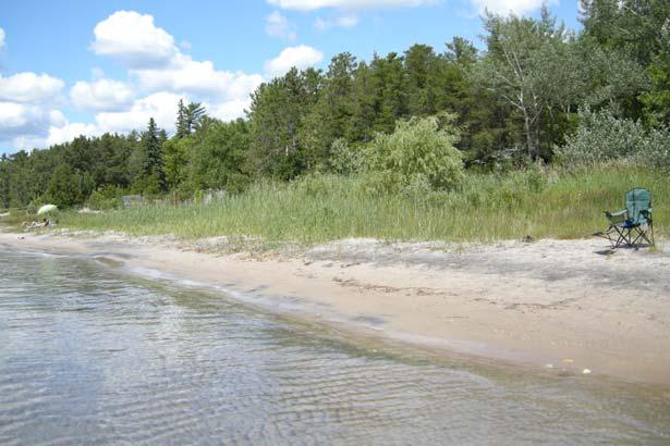
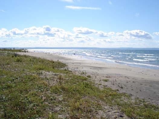
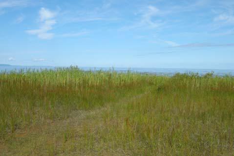
2 Nice beach and vegetation
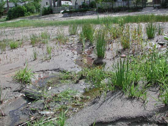
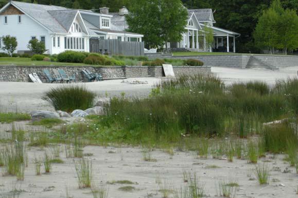
3 Problem vegetation


4 Why do different beaches have different vegetation?
5 these conditions relates to the hydrological (water characteristics) of the beach... Do you have a DRY BEACH? Do you have a WET BEACH?
6 Types of beaches: Dry Beach dry sand, only plant is beach grass (American Beach Grass or Marram Grass)
7 Types of beaches: Wet Beach beach: flat (no dunes), wet sand, many plants
8 Depth to water table at dry beach elev. above lake (m) high ground surface deep water table 0.5 m to >4.0 m lake beach usually coarse sand dunes water table distance from shore (m)
9 Depth to water table at wet beach flat ground surface shallow water table 0.0 m to 0.5 m elev. above lake (m) lake lake 0 beach beach usually fine sand no dunes no dunes water table distance from shore (m)
10 Water content vs. type of beach Dry Beach: - low moisture content in sand above wt - no water in sand at surface Wet Beach: - high moisture content in sand above wt - moist or wet sand at surface
11 Water content vs. type of beach Dry Beach = dry sand - essentially no infiltration of rain - no surface runoff after rain - no ponding of water Wet Beach = wet sand - rain will infiltration to w.t. - surface runoff after rain - ponding of water


12 Vegetation on beaches type of vegetation relates to type of beach Dry Beach: - deep water table, dry sand - little infiltration of rain - plans adapted to dry conditions Wet Beach: - shallow water table, wet sand - lots of infiltration of rain - just about any plant

13 Vegetation on dry beaches
14 Vegetation on wet beaches native plants do not grow well on wet beaches 2 types of invasive plants on wet beaches exotic species: - not native to Great Lakes - Phragmites turf grass - opportunistic


15 Vegetation on wet beaches 2 types of invasive plants on wet beaches native species: - native to wet shorelines - sedge, cattails, bulrush, silverweed, etc. - opportunistic

16 The wet beach cycle wet sand shallow water table hold more water establish plants reduces sand pores adds organic material die-back during fall
17 What caused vegetation problems? Natural Events... low lake levels Community / Resident Actions... remove dunes External Pressures... invasive Phragmites


18 Impact of low lake levels expose more of lake bed = a wider beach but also flatter and wetter impact depends on: - dunes vs. flat beach - if beach grass is present


19 Impact of low lake levels no dunes + no beach grass = problem - loss of sand no beach grass to hold sand - maintain a shallow water table
20 Impact of low lake levels dunes + beach grass = less problem beach grass holds sand beach grass and dune migrates towards lake

21 Impact of people removing sand dunes and beach grass nothing to hold sand promote shallow w.t. -leads to wet beaches - provide wet conditions for plants


22 Impact of people lawns planted next to beach grass will get on to beach


23 Impact of people turf grass on a beach will attract geese! leads to E. coli in lake water & sand


24 Can anything be done? in some case... NO - may need to remove all vegetation and beach sand (roots & organic matter) - wet is the natural state wet cobble beach wet sand beach
25 Can anything be done? but in many cases... YES - when lake levels rise? - increase depth to water table?

26 Increase depth to water table slightly higher ground surface relative to the water table will form a dry beach small elev. change other plants damp sand beach grass dry sand
 20-30 cm of coarse sand added to surface?")
27 Increase depth to water table dry wet dry lake high low dune water table low high may be a dry beach if (high) cm of coarse sand added to surface? dry beach wet beach (low)
28 Increase depth to water table BUT... placing sand on top of vegetation may not work - roots remain at water table - plant grows through sand add sand Must remove vegetation before adding sand


29 How do you raise the ground surface? Sand Fencing accumulates sand at fence and 10 to 15 m beyond fence best time late fall (but can keep all year) stabilize accumulated sand with beach grass Friends of Sauble Beach start building dunes at wet beaches
 put clean sand at base of")
30 How do you raise the ground surface? Move existing dunes towards lake (sand dune & beach grass migrates towards lake) put clean sand at base of dune or let sand naturally accumulate plant beach grass on top of sand

")
31 How do you raise ground surface? American Beach Grass (Ammophila breviligulata) before - traps sand - builds dunes after
32 What can you do? Protect/restore sand dunes and beach grass Don t plant lawns (natural landscaping) Stop drainage onto beaches (municipal storm drains, residential pavement) Consult Park experts about your beach sand, vegetation, and best management practices Educate your neighbours
Nothing So Constant as Change
 Nothing So Constant as Change By Ron Schaper Dynamic Environments 1) Lake Levels 2) Beach Size 3) Cliff Erosion 4) Beach and Cliff Plant Communities 1) Lake Levels (Michigan/Huron) More than 20,000 years
* Appalachian Mountains -the mountain range in the Eastern U.S. which terminates in north-central Alabama
 MR. SAND TEACHER'S MANUAL INTRODUCTION: Although Mr. Sand is a cartoon presentation that is attractive to children (of all ages), the material is technically accurate and quite significant to our understanding
Figure 1. Schematic illustration of the major environments on Mustang Island.
 STOP #1: PACKERY CHANNEL BEACH TO BAY We will start this field guide near the north jetty of Packery Channel and hike across the island to Corpus Christi Bay (fig. 1). The island emerges from the Gulf
Chesil Beach, Dorset UK High energy, shingle coastline. Brighton Beach, Sussex UK Pebble beach
 Beaches: Depositional landform Extends from the highest high tide to the lowest low tide. Very important temporary store in coastal system. Accretion: sediment returning to the visible portion of a beach
Habitat Fact Sheets. Rocky habitats are dominated by seaweeds and often mussels, which rely on the rocks for attachment.
 Habitat Fact Sheets Habitats in the Gulf of Maine serve many important roles for the environment and for humans as well. These include: cycling nutrients, filtering pollution, trapping sediments, storing
Greg Berman (WHOI Sea Grant & Cape Cod Cooperative Extension) November 2, 2017
 November 2, 2017") November 2, 2017 Are You Ready for the Next Big Storm?: A Workshop for Hardy Cape Codders Greg Berman (WHOI Sea Grant & Cape Cod Cooperative Extension) Outline: ~30 min talk & time for questions Practical
November 2, 2017 Are You Ready for the Next Big Storm?: A Workshop for Hardy Cape Codders Greg Berman (WHOI Sea Grant & Cape Cod Cooperative Extension) Outline: ~30 min talk & time for questions Practical
GONE! Coastal Erosion Happens During Storms! Why Worry About Coastal Setbacks? Goals for Today
 RI Regulatory Setbacks & Buffers: Coastal Zone Management Issues New England Onsite Wastewater Training Program @ URI OWT 155 November 21, 2013 Goals for Today Understand the impacts of storms, coastal
The Sand Beaches of New Hampshire and Maine
 The Sand Beaches of New Hampshire and Maine Beach Preservation and Erosion Control Photographs provided by Joe Kelly and Steve Adams Cover photo: Reid State Park, ME Introduction The sand beaches of New
3.0 Basin and Watershed Characteristics
 3.0 Basin and Watershed Characteristics 3.1 Basin Characteristics 3.1.1 Crystal Lake Crystal Lake, located in the cities of Burnsville and Lakeville (Dakota County), covers an area of approximately 292
1. THE ESSENCE OF DROUIN GOLF & COUNTRY CLUB
 1. THE ESSENCE OF DROUIN GOLF & COUNTRY CLUB Drouin is unique as it is the only 27 hole golf course in the Gippsland region. The course presents three differing layouts to members and visitors combining
RI Regulatory Setbacks & Buffers: Coastal Management Issues
 RI Regulatory Setbacks & Buffers: Coastal Management Issues New England Onsite Wastewater Training Program @ URI OWT 155 - November 29, 2012 James Boyd - Coastal Policy Analyst Photo: October 30, 2012
VIMS CCRM Coastal Management Decision Tools. Decision Tree for Undefended Shorelines and Those with Failed Structures
 VIMS CCRM Coastal Management Decision Tools Decision Tree for Undefended Shorelines and Those with Failed Structures Center for Coastal Resources Management Virginia Institute of Marine Science Gloucester
HEALTHY SHORELINE HEALTHY YOU!
 HEALTHY SHORELINE HEALTHY YOU! A guide for sustainable shoreline properties in the Township of Huron-Kinloss LAKE HURON CONTENTS PURPOSE OF THIS GUIDE 1 2 3 4 5 6 8 10 12 14 16 18 20 Purpose of this Guide
Creation of Fish and Wildlife Habitat on the Closed Salmon Harbour Mine in Minto, NB
 Creation of Fish and Wildlife Habitat on the Closed Salmon Harbour Mine in Minto, NB M. Coleman 1, R. Rutherford 2, RA Currie 3 1 NB Power 2 Thaumas Environmental Consultants Ltd 3 RA Currie Ltd. Location
Puget Sound Shorelines. Waves and coastal processes. Puget Sound shorelines: Effects of beach armoring
 Puget Sound Shorelines Puget Sound shorelines: Effects of beach armoring Waves and coastal processes Factors affecting wave energy hitting the coast Processes transporting sediment along coastlines What
Leaning Into Adaptation
 www.marinslr.org Leaning Into Adaptation GFNMS Ocean Summit, May 17, 2016 Jack Liebster, Planning Manager, Marin County Marin County C-SMART Sea Level Rise Adaptation Process Evaluate Science Info. Implement
Adapting to Climate Change In Coastal Environments
 Adapting to Climate Change In Coastal Environments Peter Nimmrichter, P.Eng. AMEC Earth and Environmental, Mississauga, Ontario 19/11/2007 1 The Great Lakes Watershed The Great Lakes cover an area of 244,160
The Dynamic Coast. Right Place Resources. A presentation about the interaction between the dynamic coast and people
 The Dynamic Coast Houses threatened by coastal erosion in California Right Place Resources A presentation about the interaction between the dynamic coast and people For the rest of the presentations in
Coastal Change and Conflict
 Coastal Change and Conflict Outline of the Topic Contrasting Coasts why do all coasts not look the same? Geology of the coast the impact rock structure has on the coastline Waves Constructive and destructive
ATLANTIC COUNTY 2006 to 2008
 ATLANTIC COUNTY 2006 to 2008 The Atlantic County oceanfront shoreline consists of three barrier islands where the northern one, Little Beach Island and a third of the second, Brigantine Island, are undeveloped
2. The phrases on the left in the following box occur in the text. Match each of them with a phrase on the right. (i) an endless stretch of sand
 an endless stretch of sand") A desert is generally without water and vegetation. A green patch with fresh water and green trees in the middle of a vast desert is a beautiful sight. A desert may be too hot or too cold. THOSE of us
A desert is generally without water and vegetation. A green patch with fresh water and green trees in the middle of a vast desert is a beautiful sight. A desert may be too hot or too cold. THOSE of us
SLSNZ EST Sand Dune Restoration Program. Protecting our Beach Environment into The Future For the next 100 Years +
 SLSNZ EST 1910 Sand Dune Restoration Program Protecting our Beach Environment into The Future For the next 100 Years + We have all been told about the effects of sea level rise due to global warning! But
Track Use and Maintenance Guidelines
 Precision Sports Surfaces, Inc. 3325 Lobban Place, Charlottesville, VA 22903 (434) 971-9628 Fax (434) 971-1131 www.precisionsurfaces.com Track Use and Maintenance Guidelines The following information is
Introducing the Great Lakes
 Introducing the Great Lakes Just a few years ago, geologically speaking, a glacier passed this way, and that's why the Midwest has the Great Lakes. Size The Great Lakes and their connecting channels form
Researchers propose a cost effective solution for failing native soil athletic fields across Michigan.
 Sand Cap Build-up Systems for Michigan High School Fields A.R. Kowalewski, J.R. Crum and J.N. Rogers, III Department of Crop and Soil Sciences Michigan State University January 2008 Researchers propose
GUIDE TO LAYING ARTIFICIAL GRASS
 GUIDE TO LAYING ARTIFICIAL GRASS Laying the base for artificial turf Remove old grass and make sure the surface is smooth. Then add a 5 cm sand bed using building sand. By soaking and compacting the sand
Natural Bridges Field Trip Activity
 Natural Bridges Field Trip Activity This is due in class on MONDAY- March 1 - not in sections! Name TA: NOTE ON THE GRADING OF THIS ASSIGNMENT: Many of the questions below (especially in the tidepool part)
Unit 11 Lesson 2 How Does Ocean Water Move? Copyright Houghton Mifflin Harcourt Publishing Company
 Unit 11 Lesson 2 How Does Ocean Water Move? Catch a Wave A wave is the up-and-down movement of surface water. Catch a Wave Catch a Wave (wave effects) Surface waves are caused by wind pushing against
West Africa Desertification in West Africa
 Non-fiction: West Africa Desertification in West Africa West Africa Desertification in West Africa In Arabic, Sahel means shore, or coast. The Sahel is the place where the waves of the ocean crash onto
Importance of Dunes Sign. Kim Scarola Suzanne Merrick Ariana Perez Johanna Mead
 Importance of Dunes Sign Kim Scarola Suzanne Merrick Ariana Perez Johanna Mead What role do dunes play in our coastlines? Part of a system of sand deposits and withdraws that helps keep the sand on our
8/29/20098 SAHRA - Watershed Visualization
 Module 3 Narration Southwestern Water Cycle 001.wav 26 sec 002.wav 10 sec 003 wav 17 sec Water on Earth is constantly on the move. Water continually circulates between the surface of Earth and the atmosphere
Interim results The Sand Motor: driver of innovative coast maintenance
 Interim results 2011-2015 The Sand Motor: driver of innovative coast maintenance The Sand Motor The coast between Ter Heijde and Kijkduin acquired a new landmark in 2011: the Sand Motor, a large artificial
Grade 8 Science: Unit 1 Water Systems Chapter 3
 Heat Capacity Grade 8 Science: Unit 1 Water Systems Chapter 3 Heat capacity ( ) is the amount of heat that a substance can hold. has a high heat capacity it can take in a large amount of heat before its
Cove Point Beach Restoration: Utilization of a Spawning Habitat by Horseshoe Crabs (Limulus polyphemus)
") Cove Point Beach Restoration: Utilization of a Spawning Habitat by Horseshoe Crabs (Limulus polyphemus) Paul Bushmann, Jessica Peterson, Bethany Enyeart and Deborah Smith Anne Arundel Community College
Cove Point Beach Restoration: Utilization of a Spawning Habitat by Horseshoe Crabs (Limulus polyphemus) Paul Bushmann, Jessica Peterson, Bethany Enyeart and Deborah Smith Anne Arundel Community College
Canada s Natural Systems. Canadian Geography 1202
 Canada s Natural Systems Canadian Geography 1202 Canada s Natural Systems Natural System: A system found in nature Here are the four natural systems that we will explore in the next few weeks 1. Canada
Collaboration: Sea-level Marin Adaptation Response Team (C-SMART)
") Collaboration: Sea-level Marin Adaptation Response Team (C-SMART) Photo Credit : Lighthawk Aerial Community Development Agency 3501 Civic Center Drive, Rm. 308 San Rafael, CA 94903 415 4736269 T www.marinslr.org
Collaboration: Sea-level Marin Adaptation Response Team (C-SMART) Photo Credit : Lighthawk Aerial Community Development Agency 3501 Civic Center Drive, Rm. 308 San Rafael, CA 94903 415 4736269 T www.marinslr.org
Coastal management has lagged behind the growth in population leading to problems with pollution
 Fifty percent of the population of the industrialized world lives within 100 km of a coast. Coastal management has lagged behind the growth in population leading to problems with pollution and natural
SALINITY. It's the amount of dissolved salts the water contains.
 AQUATIC ECOSYSTEMS SALINITY The types of organisms in an aquatic ecosystem depend upon the water s Salinity. It's the amount of dissolved salts the water contains. Salinity determines the two main aquatic
Reading Material. Inshore oceanography, Anikouchine and Sternberg The World Ocean, Prentice-Hall
 Reading Material Inshore oceanography, Anikouchine and Sternberg The World Ocean, Prentice-Hall BEACH PROCESSES AND COASTAL ENVIRONMENTS COASTAL FEATURES Cross section Map view Terminology for Coastal
North Carolina Sea Grant, September 2003 Please save, share or recycle
 North Carolina Sea Grant, September 2003 Please save, share or recycle Dunes T A B L E O F C O N T E N T S Chapter 1: Introduction...........................................2 What is a Dune?.....................................................2
ALTERNATIVES FOR COASTAL STORM DAMAGE MITIGATION
 ALTERNATIVES FOR COASTAL STORM DAMAGE MITIGATION Dave Basco Old Dominion University, Norfolk, Virginia, USA National Park Service Photo STRUCTURAL (changes to natural, physical system) hardening (seawalls,
located Let s go fishing Hydrilla
 Our Lake of the Month for November is Lake August (set your GPS to 27.2750-81.4136). The elevation of Lake August is 102.5. Lake August is a 52 acre dredge hole lake (man-made from a former wetland; see
Habitat Development: Habitat Boulders Lawson Pier Foreshore Enhancement
 Habitat Development: Habitat Boulders Improve the existing habitat by stabilising beach sediments. Increase biodiversity by creating new habitats and colonisation opportunities. Loose cobble is unstable;
Volume and Shoreline Changes along Pinellas County Beaches during Tropical Storm Debby
 Volume and Shoreline Changes along Pinellas County Beaches during Tropical Storm Debby Ping Wang and Tiffany M. Roberts Coastal Research Laboratory University of South Florida July 24, 2012 Introduction
Hydraulic Modeling of Stream Enhancement Methods
 Hydraulic Modeling of Stream Enhancement Methods Matthew J. Curry John J. Levitsky Abstract Development within watersheds increases the amounts of runoff causing stream erosion and degradation of stream
RESILIENCE THROUGH RESTORATION
 RESILIENCE THROUGH RESTORATION RECLAMATION DISTRICT NO. 1601 TWITCHELL ISLAND SAN JOAQUIN RIVER SETBACK LEVEE PROJECT TWITCHELL ISLAND BASICS Nearly 12 miles of levee Storm drainage facilities Protects
Basic Dune Physical Characteristics
 Basic Dune Physical Characteristics New Jersey s Beach and Dune Characteristics Dunes in New Jersey are mainly confined to a narrow strip of land between the beach berm and upland development. While there
Notepack 41. Aim: What factors determine the climate of a certain area? Do Now: What is the difference between weather and climate?
 Notepack 41 Aim: What factors determine the climate of a certain area? Do Now: What is the difference between weather and climate? WEATHER VS. CLIMATE Weather atmospheric conditions at a certain location
Climate Change and Hydrology in the Sierra Nevada. Lorrie Flint U.S. Geological Survey Sacramento CA
 Climate Change and Hydrology in the Sierra Nevada Lorrie Flint U.S. Geological Survey Sacramento CA Discussion Topics Climate change for California Methods to evaluate hydrologic impacts Water balance
Conservation and Restoration Florida s Coastal Marshes: An Overview of MESS. Jeff Beal, Kent Smith, Erin McDevitt, Maria Merrill
 Conservation and Restoration Florida s Coastal Marshes: An Overview of MESS Jeff Beal, Kent Smith, Erin McDevitt, Maria Merrill FWC s MESS: -Marine/Estuarine Subsection -within Aquatic Habitat Conservation
The Summer of 2007: A Look at Niagara
 The Summer of 27: A Look at Niagara By Wayne Heinen (maps generated by Piper McKinnon) OVERVIEW The summer of 27 was yet another challenging growing season. One look at the inch-wide cracks in the soil,
UNIT 1: WATER SYSTEMS ON EARTH CHAPTER 3
 UNIT 1: WATER SYSTEMS ON EARTH CHAPTER 3 HEAT CAPACITY HEAT CAPACITY (SPECIFIC HEAT CAPACITY) IS THE AMOUNT OF HEAT THAT A SUBSTANCE CAN HOLD WATER HAS A HIGH HEAT CAPACITY IT CAN TAKE IN A LARGE AMOUNT
Aquatic Invasive Species. September 30 th, 2014, NOFNEC
 Aquatic Invasive Species September 30 th, 2014, NOFNEC Overview Introduction Invasive Species of Concern Round Goby Phragmites Asian Carps How can you help? Decontamination Resources AOFRC 2 Introduction
For more information: Photography: Rijkswaterstaat (Leo Linnartz, Carrie de Wilde, Jurriaan Brobbel, Joop van Houdt), Deltares
, Deltares") Investing in your future. This project was made possible with support from the European Regional Development Fund. Photography: Rijkswaterstaat (Leo Linnartz, Carrie de Wilde, Jurriaan Brobbel, Joop van
Investing in your future. This project was made possible with support from the European Regional Development Fund. Photography: Rijkswaterstaat (Leo Linnartz, Carrie de Wilde, Jurriaan Brobbel, Joop van
Warm-up # 7 A day 5/17 - B day 5/18 UPDATE YOUR TABLE OF CONTENTS
 Warm-up # 7 A day 5/17 - B day 5/18 UPDATE YOUR TABLE OF CONTENTS Question: List all examples of surface water on Earth. Answer: Rivers and streams, lakes and reservoirs, (ponds) wetlands, estuaries and
ALTERNATIVES FOR COASTAL STORM DAMAGE MITIGATION AND FUNCTIONAL DESIGN OF COASTAL STRUCTURES
 The University of the West Indies Organization of American States PROFESSIONAL DEVELOPMENT PROGRAMME: COASTAL INFRASTRUCTURE DESIGN, CONSTRUCTION AND MAINTENANCE A COURSE IN COASTAL DEFENSE SYSTEMS I CHAPTER
Report Prepared for Glen Oak Country Club September 2016 Turfgrass Disease Solutions, LLC Steven McDonald, M.S. On Saturday September 3 rd, I visited
 Report Prepared for Glen Oak Country Club September 2016 Turfgrass Disease Solutions, LLC Steven McDonald, M.S. On Saturday September 3 rd, I visited Glen Oak Country Club to discuss agronomics. The 2016
A FISHING BAN ON GRENADIER POND
 A FISHING BAN ON GRENADIER POND The activity or sport of fishing should be banned commencing spring of 2013 pending a study to determine whether, and in what particular circumstances, fishing can be considered
The Loon Pond Experience
 Bridgewater State University Virtual Commons - Bridgewater State University Watershed Access Lab Projects Watershed Access Lab 2005 The Loon Pond Experience Recommended Citation Apponequet Regional High
Water Management Plan For The Blue Ocean Golf Club
 Water Management Plan For The Blue Ocean Golf Club A water management plan reviews current water management practices and identifies opportunities for improvement in water use efficiency/conservation for
CHEBACCO LAKE & WATERSHED ASSOCIATION Newsletter
 CHEBACCO LAKE & WATERSHED ASSOCIATION Newsletter A Quarterly Publication of the Chebacco Lake & Watershed Association www.chebaccolake.org May 2012 Notes from Around the Lake Another summer season on the
CITY OF SALEM DEPARTMENT OF PUBLIC WORKS STANDARD DRAWINGS TABLE OF CONTENTS
 001-099 100-199 200-299 Stormwater 300-399 400-499 500-599 600-699 700-799 800-899 Miscellaneous Sewers and Drains Streets Water Structures Earthwork Street Lighting and Traffic Signals Landscape and Irrigation
Overview. Beach Features. Coastal Regions. Other Beach Profile Features. CHAPTER 10 The Coast: Beaches and Shoreline Processes.
 Overview CHAPTER 10 The Coast: Beaches and Shoreline Processes Coastal regions constantly change. The beach is a dominant coastal feature. Wave activity continually modifies the beach and coastal areas.
For more information or permission to reprint slides, please contact Donna Milligan at 1
 For more information or permission to reprint slides, please contact Donna Milligan at milligan@vims.edu 1 For more information or permission to reprint slides, please contact Donna Milligan at milligan@vims.edu
For Creative Minds. Salt Marsh Plants and Animals
 For Creative Minds The For Creative Minds educational section may be photocopied or printed from our website by the owner of this book for educational, non-commercial uses. Cross-curricular teaching activities,
Blakely Island, N Thatcher Bay. Restoration Recommendation: Rank Score (total score)
") Soft Shore Protection/Structure Removal Blueprint for San Juan County Forage Fish Beaches Appendix 2: Recommendations for sites scoring below the top ten, sorted by island (east to west) Blakely Island,
Soft Shore Protection/Structure Removal Blueprint for San Juan County Forage Fish Beaches Appendix 2: Recommendations for sites scoring below the top ten, sorted by island (east to west) Blakely Island,
INFILTRATION PRACTICE MAINTENANCE INSPECTION FORM
 Facility Number: Date: Time: Subdivision Name: Watershed: Weather: Inspector(s): Date of Last Rainfall: Amount: Inches Streets: Mapbook Location: GPS Coordinates: Property Classification: Residential 9
Suitable Applications Check dams may be appropriate in the following situations: To promote sedimentation behind the dam.
 Categories EC Erosion Control SE Sediment Control TC Tracking Control WE Wind Erosion Control Non-Stormwater NS Management Control Waste Management and WM Materials Pollution Control Legend: Primary Category
Osoyoos Lake Aquatic Plant Mapping
 Osoyoos Lake Aquatic Plant Mapping AquaTechnex, LLC Presented to Okanogan County NWCB by PO Box 30824 Bellingham WA, 98228 www.aquatechnex.com Introductions Myriophyllum spicatum or Eurasian Milfoil has
4.7 Landscape Provisions.
 4.7. A. Intent. Landscaping of required Yards and required Bufferyards is an essential element of the design of a site with respect to promoting the public health, safety, comfort, convenience and general
Golf Course Managers Monthly Report
 Golf Course Managers Monthly Report Church Course MAINTENANCE Water Management on a Links Golf Course Low spots The term links historically applies specifically to strips of land in seaside areas that
Texas passes, longshore transport, hurricanes, beach erosion and sea level
 Texas passes, longshore transport, hurricanes, beach erosion and sea level Richard L. Watson, Ph.D. (361) 749-4152 Field work can be strange! 120,000 years of sea level Years each zone exposed above S/L
RLRC COMMUNITIES EAST GRAND FORKS AREA CHARACTER THE RED LAKE RIVER & THE RED RIVER OF THE NORTH CONFLUENCE EAGLE POINT BOAT LAUNCH DESIGN
 AREA CHARACTER THE RED LAKE RIVER & THE RED RIVER OF THE NORTH CONFLUENCE EAGLE POINT BOAT LAUNCH DESIGN DESIGN DETAILS 135 AREA CHARACTER East Grand Forks a city of 7,501 people is located across the
THIEF LAKE WILDLIFE MANAGEMENT AREA NEWSLETTER
 THIEF LAKE WILDLIFE MANAGEMENT AREA NEWSLETTER Volume 16 Issue 1 August 2017 Editor s Note: If you know of others who might be interested in this information, please send us their address. If you received
1. Distribute the activity sheet, and allow 20 minutes for the first use.
 A LOCAL WAY OF LEARNING Title: MISSING MANGROVE MESSAGE Author: Eulalie R. Rivera Elementary School Environmental Education Team Grade Level: 4-6 Concepts: 2.Ecosystem 6.Resources 9.Change Disciplines:
Glossary. Saugeen Shores Beach Maintenance Plan
 Glossary Saugeen Shores Beach Maintenance Plan Page Level of Service 4 Vegetation Growth 4 Species at Risk 5 Activities Defined 5 Maintenance Area 1 7 Maintenance Area 2 10 Maintenance Area 3 13 Maintenance
Seagrasses of the Virgin Islands
 Seagrasses of the Virgin Islands Seagrasses are flowering plants that live underwater. These marine plants resemble the land species of grasses in that they have long blade-like leaves. Seagrasses grow
Overview. What are Corals?
 Overview Coral Reefs extend back over 500 m.y. Grow in tropical seas with normal salinity Support a great variety of plant and animal life Cover less than 0.2% of sea floor Contain about 25% of marine
Chapter- 9. Multiple Choice Questions
 Chapter- 9 Multiple Choice Questions 1. The low-latitude climates: a. are located along the equator b. are located between the tropics of cancer and capricorn c. do not include the ITCZ d. are restricted
Shoreline Studies Program, Department of Physical Sciences, VIMS
 Living Shoreline Training Class 2017 1 Demonstration sites discussed in this talk. 2 A shoreline management plan for the entire creek made conceptual shoreline management recommendations along every stretch
Our foundation introduce Nature and conservation in Lake Izunuma Uchinuma.
 Our foundation introduce Nature and conservation in Lake Izunuma Uchinuma. The photo shows morning flight of greater white fronted geese. The geese leave their roosts for foraging at rice fields in the
PHOMA MACROSTOMA: A BIOHERBICIDE IN THE MAKING
 FIGURE 1: PHOMA MACROSTOMA ON CANADA THISTLE PHOMA MACROSTOMA: A BIOHERBICIDE IN THE MAKING K.L. BAILEY (AGRICULTURE & AGRI-FOOD CANADA, SASKATOON) AND S. FALK & S. LOMBARDO (THE SCOTTS COMPANY, MARYSVILLE,
Protecting our Beaches
 Protecting our Beaches South Amelia Island Shore Stabilization Project Nassau County, FL Mr. Drew Wallace President South Amelia Island Shore Stabilization Association (SAISSA) Mr. Bill Moore, AICP Project
Transforming Chadwick Lake
 Transforming Chadwick Lake Chadwick Lake has been going through a process of renovation over the past two years. Management of the area began with a vision statement of producing an ecosystem comprised
Low Gradient Velocity Control Short Term Steep Gradient Channel Lining Medium-Long Term Outlet Control Soil Treatment Permanent [1]
![Low Gradient Velocity Control Short Term Steep Gradient Channel Lining Medium-Long Term Outlet Control Soil Treatment Permanent [1]](/thumbs/80/80811988.jpg "Low Gradient Velocity Control Short Term Steep Gradient Channel Lining Medium-Long Term Outlet Control Soil Treatment Permanent [1]") Check Dams DRAINAGE CONTROL TECHNIQUE Low Gradient Velocity Control Short Term Steep Gradient Channel Lining Medium-Long Term Outlet Control Soil Treatment Permanent [1] [1] Though not generally considered
Check Dams DRAINAGE CONTROL TECHNIQUE Low Gradient Velocity Control Short Term Steep Gradient Channel Lining Medium-Long Term Outlet Control Soil Treatment Permanent [1] [1] Though not generally considered
Marine Ecosystems. Aquatic Ecosystems Section 2
 Marine Ecosystems Marine ecosystems are located mainly in coastal areas and in the open ocean. Organisms that live in coastal areas adapt to changes in water level and salinity. Organisms that live in
By Gloria Hildebrandt Photographed by Mike Davis except where noted
 FOLLOWING THE FISH: Owen Sound s Salmon Run By Gloria Hildebrandt Photographed by Mike Davis except where noted SALMON LIVE IN THE GREAT LAKES and the rivers of the Niagara Escarpment that drain into the
WHO POLLUTED THE POTOMAC RIVER?
 WHO POLLUTED THE POTOMAC RIVER? [Walk over to the map and point to it while saying,] Let s take a look at a map of the state of Maryland. Way out in the western part of the state, we see a small body of
SHOREHAM BEACH LOCAL NATURE RESERVE
 SHOREHAM BEACH LOCAL NATURE RESERVE Coastal Geography Education Programme 2014-15 S. Savage 2014 COASTAL GEOGRAPHY OPPORTUNITIES Shoreham Beach Shoreham Beach is a shingle spit formed over many centuries
REPORT TO THE MINISTER OF NATURAL RESOURCES. Pursuant to an appointment made by the Honourable Frank S. Miller, Minister of Natural
 Room 569, Fifth Floor, Mowat Block, Queen's Park, Toronto, Ontario. M7A la2 IN THE MATTER OF The Lakes and Rivers Improvement Act; AND IN THE MATTER OF An application by Rudolph Adam for approval under
Barnegat Bay-Friendly Golf Course Certification Program
 Barnegat Bay-Friendly Golf Course Certification Program Businesses for a Better Barnegat Bay Thank you for your interest in becoming a Certified, Barnegat Bay-Friendly Golf Course. This American Littoral
Managing Vertebrate Pests
 Managing Vertebrate Pests Legal Restrictions: Special laws and regulations restrict how and when you can hunt and kill many vertebrates (unlike insects) Migratory Bird Treaty Act Pesticide Laws Endangered
Weather EOG Review Questions
 Weather EOG Review Questions 1. Which statement best describes runoff? A Water vapor cools off and changes into water droplets. B Water in the form of rain, snow, sleet, or hail falls from clouds. C Precipitation
Lesson 1 What is a Watershed?
 What is a Watershed? Essential Question: What is a watershed? Objective: Students will be able to explain the components of a watershed and its effects on the environment through analysis of a model. Next
San Gabriel River Ranch 240 ACRES FOR SALE IN WILLIAMSON COUNTY
 San Gabriel River Ranch 240 ACRES FOR SALE IN WILLIAMSON COUNTY Aerial Map Lake Belton Ranch DESCRIPTION: WATER OVERVIEW: Available for the first time in over 100 years, this is a rare opportunity to own
Building Coastal Resiliency at Plymouth Long Beach
 Building Coastal Resiliency at Plymouth Long Beach Department of Marine and Environmental Affairs March 30, 2017 Introducing Green Infrastructure for Coastal Resiliency Plymouth Long Beach & Warren s Cove
BEACH PROCESSES AND COASTAL ENVIRONMENTS
 BEACH PROCESSES AND COASTAL ENVIRONMENTS COASTAL FEATURES Cross section Map view TOPICS: Terminology Waves Beach Morphology Barriers Coastal Migration Tides Tidal Flats and Marshes Sediment Budgets Human
Spring YOURCOURSE BIGGA Aeration.indd 46 11/01/ :37
 46 YOURCOURSESpring2018 WHY ARE YOU DIGGING UP OUR GREENS AGAIN? Aeration is one of the greenkeeper s most powerful means of improving turf quality but it makes the golfer s heart sink. Steve Carroll finds
EFFICACITÉ D UN RECOUVREMENT MONOCOUCHE PLACÉ SUR DES REJETS MINIERS GÉNÉRATEUR D EAUX ACIDES
 Réunion du comité scientifique Chaire CRSNG Polytechnique-UQAT Environnement et gestion des rejets miniers EFFICACITÉ D UN RECOUVREMENT MONOCOUCHE PLACÉ SUR DES REJETS MINIERS GÉNÉRATEUR D EAUX ACIDES
Anguilla. Wise practices for coping with. i b bea n Se a
 Wise practices for coping with Anguilla Car i b bea n Se a Department of Fisheries and Marine Resources, Anguilla Department of Physical Planning, Anguilla University of Puerto Rico, Sea Grant College