An Atlas of Oceanic Internal Solitary Waves (May 2002) by Global Ocean Associates Prepared for the Office of Naval Research - Code 322PO
|
|
|
- Kathryn Burns
- 6 years ago
- Views:
Transcription
1 Overview is located along the eastern side of the Indian Ocean between the Malay Peninsula and the Andaman and Nicobar Islands (between approximately 6 o to 14 o N. latitude and 93 o to 99 o E. longitude). It is a maritime regime containing internal solitary waves of extraordinary amplitude (>60 m), wavelength (6-15 km), and speed (> 2.0 m/s). As far back as the mid-19 th century surface manifestations of solitons have been observed consisting of strong bands of surface roughness. These bands were referred to as "ripplings", due to their mistaken association with rip tides. A description of such bands can be found in the book of Maury (1861) published in 1861 and which is quoted in Osborne and Burch (1980): "In the entrance of the Malacca Straits, near Nicobar and Acheen Islands, and between them and Junkseylon, there are often strong ripplings, particularly in the southwest monsoon; these are alarming to persons unacquainted, for the broken water makes a great noise when the ship is passing through the ripplings at night. In most places ripplings are thought to be produced by strong currents, but here they are frequently seen when there is no perceptible current so as to produce an error in the course and distance sailed, yet the surface if the water is impelled forward by some undiscovered cause. The ripplings are seen in calm weather approaching from a distance, and in the night their noise is heard a considerable time before they come near. They beat against the sides of the ship with great violence, and pass on, the spray sometimes coming on deck; and a small boat could not always resist the turbulence of these remarkable ripplings." The Andaman and Nicobar Islands on the western side of the Andaman Sea are volcanic in origin. As a result the water depth in the region changes rapidly from over 3000 m in the Indian Ocean, to approximately 200 m in the areas around the islands, returning to m in the Andaman Sea (Figure 1). These bathymetric changes take place over approximately 150-km horizontal distance. The sills between the islands, as well as a number of underwater volcanic seamounts, are all potential sources of internal waves. The result is an area rich in internal wave excitations and complex soliton - soliton interaction. Space Shuttle photography from May 1985 (figure 5) clearly shows a source of internal waves in or near the Sombreno Channel, at the south end of Nancowry Island. Alpers et al. (1997) has examined SAR images from ERS-1/2 acquired by the receiving station in Singapore that became operational in He reports km x 100 km SAR scenes collected over the Andaman Sea available for his investigation. Using the ERS scene in figure 6, in connection with other images, Alpers estimated three sources for the waves: 207

2 Figure 1: Bathymetry map of the Andaman Sea. (Bathymetry derived from Smith and Sandwell version 8.2) 208
3 the shallow reefs off the northwest coast of Sumatra, around 6 10 N E. (Indonesian name: Alur Pelayaran Bengala), where, near the 1000 m depth line, a coral reef rises up to a depth of 30 m below the sea surface, the seamounts at 8 50 N E.; 9 04 N E.; and 8 42 N E., which have depths of 481 m, 671 m, and 680 m, respectively, and which are located in an ambient sea area which has a depth of more than 2500 m, and a submarine bank located at N E. which rises from a 1800 m to 2500 m deep ocean floor to a depth of 88 m below the sea surface. In addition, at least one source must exist in the northeastern part of the Andaman to account for westward propagating internal waves observed in SIR-A (figure 8) and DMSP (figure 9) images. Table 1 presents a summary of internal wave characteristics from the Andaman Sea. The values have been reported in the literature and derived from both in-situ and remote sensing data sources. Table 2 shows the months of the year during when internal waves have been observed in the Andaman Sea. It is believed that the waves occur year round and that the August and September gap would be eliminated with the examination of more imagery. Packet Length L (km) Table 1. Characteristic Scales for Andaman Sea Solitons Along Crest Length C r (km) Maximum Wavelength λ MAX (km) Internal Packet Distance D (km) Amplitude 2η 0 (m) Long Wave Speed c 0 (m/s) Wave Period (min) Surface Width l 1 (m) -60 to -70 > Table 2 - Months when Internal Waves have been observed In the Andaman Sea. Jan Feb Mar Apr May Jun Jul Aug Sept Oct Nov Dec X X X X X X X X X X Observations The first scientific reports of such large waves in the Andaman appear to have come from Perry and Schimke (1965) who, in 1964, made bathythermograph observations of an 80-meteramplitude internal wave that had audible, breaking surface waves accompanying it. In late 1975 and early 1976 Osborne et al. (1978) and Osborne and Burch (1980) carried out current-meter measurements on several packets of internal waves that had amplitudes of up to 70 meters and current speeds in excess of 2 meter per second and established their soliton like character. Figures 2 and 3 (from Osborne and Burch (1980)) show the temperature variations of internal waves measured in October The data in figure 2 show a thermistor chain temperature measurement taken during the passage of an internal wave packet and show the packets characteristic rank ordered signal. Osborne and Burch (1980) reported the lead 209
4 Figure 2. Temperature signals of an internal wave packet recorded by thermistor chain on 24 October 1976 at 6 o 53' N. and 97 o 04' E. (From Osborne and Burch 1980) Figure 3. Isotherms of a 60-m internal wave recorded XBT casts on 25 October 1976 at 6 o 53' N. and 97 o 04' E. (From Osborne and Burch 1980) 210
5 211
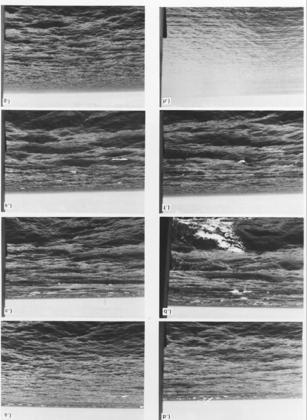
6 Figure 4 (Previous page): Sequence of Photographs of the Andaman Sea surface taken as a rip band approached from the west at a speed of 2.2 m/sec and passed the survey vessel on 27 October 1976 at 10:15 local time (Greenwich mean time +7 hours). The air temperature was 30 o C and the winds were calm during the sequence. (a) 10:15, the rip was seen in the distance stretching from one horizon to the other, as a well-defined line of breaking waves. The background sea state preceding the rip was ~0.6 m and approached from the west; (b) 10:16, the rip continued to approach in the background waves of ~0.6m; (c) 10:17, the rip had just arrived at the vessel with wave heights of ~1.8m; (d) 10:19 the survey vessel was tossed about in the 1.8-m waves of the rip band; (e) 10:22, the rearward edge of the rip was visible in 1.8-m waves; (f) 10:23, the rearward edge of the rip receded as the waves dropped to 1.3 m; (g) 10:25, the wave amplitude dropped to 0.6 m; (h) 10:32, the rip had completely passed as the waves dropped to ripples of ~0.1m. (From Osborne and Burch 1980) soliton amplitude of 60 meters. Figure 3 shows the isotherm displacement from a 60-meter internal wave obtained from XBT casts at 90-second intervals. A rip surface was observed on the leading edge. Figure 4 is a sequence of photographs published in Osborne and Burch (1980) and taken from the survey vessel during the passage of a rip band associated with an internal soliton. Imagery Internal wave signatures in the Andaman wave have been observed in astronaut photographs, DMSP, and Landsat optical images, as well as synthetic aperture radars SIR-A, ERS 1/2 and Radarsat-1. Osborne and Burch (1980) reported the detection of internal waves in over 40 LandSat images. Five of those images containing waves with crests as long as 150 km and wavelengths as great as 15 km. The joint US-USSR space mission Apollo-Soyuz (July 22, 1975), returned color photographs that showed narrow strips of rough water in the sun glint region; one such photograph (AST-7-426) [Apel, 1979; Osborne and Burch, 1980; Apel at al., 1985] shows four packets of narrow, elongated strips near the region of Puket. Apel (1979) interpreted these as surface signatures of large internal waves presumably produced by the semi-diurnal tidal flow over underwater topography; the inferred group speeds were approximately 2.5 m/sec as derived from their interpacket separation. Astronauts on the Space Shuttle (STS , 54,55) photographed a very similar scene in the sunglint region on February 27, 1996 (Fig 5). Three groups of internal waves are clearly visible, two propagating to the southeast, one to the northeast. Interpacket separation of the southeast packet is approximately 88 km with an inferred group speed of 2 m/s. The longest wave visible in the northeast group has an along crest length of around 150 km. A Space Shuttle photograph (STS51B ) taken on 5 May 1985 (Fig 6) shows two internal wave packets near Katchall and Nancowry Island. The first packet shows a continuum of waves for over 32 km as the packet propagates northeast into the Andaman Sea. The second packet, with just a few waves is seen breaking away from the lower end of Nancowry Island. This suggests that the waves originate on the shelf area just south of Katchall and Nancowry Island in the Sombreno Channel (Fig 7). The interpacket separation varies from approximately 35 km (0.78 m/s group speed) in the northeasterly direction to almost 48 km (1.1 m/s group speed) almost directly north. The variation in separation of the wavefronts could be due to advection by currents. 212

7 Figure 5. Space Shuttle Photograph (STS , 55, 56) acquired February 27, 1996, 10:30 GMT. The image dimensions are approximatly 100 x 235 kms centered near 8 o N o E. Image Courtsey of Earth Sciences and Image Analysis Laboratory, NASA Johnson Space Center ( 213

8 Figure 6. Space Shuttle Photograph (STS51B-53-97) acquired May 5, 1985, 01:42 GMT. Image dimensions are approximately 68 x 68 km centered near 8 o N. 94 o E. Image Courtesy of Earth Sciences and Image Analysis Laboratory, NASA Johnson Space Center ( 214
 shown with local bathymetry")
9 An Atlas of Oceanic Internal Solitary Waves (May 2002) Figure 7. Space Shuttle Photograph (STS51B-53-97) shown with local bathymetry 215
10 One of the most spectacular images from the Andaman Sea was acquired by ERS-2 on February 11, 1997 (figure 8). The image, a composite of 9 ERS SAR frames (3357, 3375, 3393, 3411, 3429, 3447, 3465, 3483, and 3501) and covers an ocean area of approximately 900 km x 100 km extending from the northwestern coast of Sumatra (Indonesia) towards the NNE into the Andaman Sea. The image shows an exceptional wealth of strong sea surface manifestations of internal solitary wave packets. While most internal waves observed in the Andaman Sea propagate westward towards the coast of the Maylay Peninsula, imagery has also shown westward propagating waves east of the Andaman Islands. Apel et al. (1985) analyzed synthetic aperture radar images from the Shuttle Imaging Radar-A (SIR-A) flight on November 1981 which contained several internal wave packets in the vicinity of the Andaman and Nicobar Islands [Cimino and Elachi, 1982; Ford et al., 1983]. Figure 9 is a section of the SIR-A radar image of November 11, 1981, having dimensions of 51.2 by 51.2 kilometers, with the white marks along the lower boarder being one second time ticks (or a distance of 7.14 kilometers). North is along the direction shown, at an angle of approximately 38 degrees from the lower edge. The internal solitons are revealed by the mostly dark (smooth) regions, with the associated rough regions not clearly visible, probably due to the large 43-degree earth incidence angle of the synthetic aperture radar. The SIR-A analysis produced an amplitude estimate of 60 meters and a current speed of 1.1 m/sec. Figure 10 is a visible Defense Meteorological Satellite Program (DMSP) image of the Andaman Sea from 1979 (exact acquisition date unknown). The image shows two internal wave packets east of the Andaman Islands propagating to the west southwest. The interpacket separation is approximately 110 km with giving an implied group speed of 2.4 m/sec. KDV Parameters Figure 11 shows a typical density profile for the area derived from temperature and salinity data collected on February 1, 1972 at N. latitude, E. longitude. The normalized Mode 1 2 and Mode 2 eignefunctions have been evaluated for λ = = 1100m, with H = 1000 m. For π k 0 long waves ( k 0) the maximum first mode wave speed (c 0 ) is computed to be 2.09 m/s without the effect of current shear. Figures 11e and 11f show the phase velocity and dispersion relations for the data. Table 2 presents the environmental coefficients and KDV parameters evaluated at k 0 Long Wave Speed c 0 (m/s) Table 2. Environmental Coefficients and KDV parameters (λ 0 =1100) Andaman Sea Solitons Nonlinear coefficient 1/α (m) Dispersion Factor γ 1/2 (m) Amplitude (KDV theory) η 0 (m) Non-Linear Phase Velocity V (m/s) for (s 2 =1)
 Figure 8 (Left).")
11 An Atlas of Oceanic Internal Solitary Waves (May 2002) Figure 9 (Above) L-Band HH SAR image from SIR-A taken November 11, 1981, near the Andaman Islands, showing a packet of 6 km long solitons and what is thought to be a rain squall. Image dimensions are 51.2 x 51.2 kilometers. Image is located near 12.5o N 94o E. (Photograph courtesy of the Jet Propulsion Laboratory) Figure 8 (Left). C-Band VV SAR image from ERS-2 taken February 11, Image dimensions are 100 x 900 km. The composite is made from ERS frames: 3357, 3375, 3393, 3341, 3429, 3447, 3465, 3483, and ESA. 217
 showing both eastward and westward")
12 Figure 10. DMSP image of the Andaman Sea (1979) showing both eastward and westward propagating internal wave packets. The image is approximately 1200 x 870 km 218
13 Figure 11. a) Density Profile derived from SD2 data collected on February 1, 1972 at N. latitude, E. longitude, depth = 1000 m (Source NODC Global Ocean Temperature and Salinity Profiles (Jun 1991) b) derived Brunt-Väisälä frequency N(z). c) zero flow current profile d) Normalized vertical eigenfunctions (mode 1 & 2) for 2π/k 1 = 1100m, H = 1000 m for density and velocity profiles shown e) Phase Velocity f) Dispersion relations. 219
14 References Alpers, W., H. Wang-Chen and L. Hock, "Observation of Internal Waves in the Andaman Sea by ERS SAR," Proc. 3 rd ERS Symp. on Space at the Service of our Enviornement, Florence Italy, March 1997, pp Apel, J. R., "Observations of Internal Wave Signatures in ASTP Photographs," Apollo-Soyuz Test Project II, F. El-Baz and D. M. Warner, eds., NASA SP412 (1979). Apel, J. R., D.R. Thomson, D.G. Tilley, and P. van Dyke, "Hydrodynamics and radar signatures of internal solitons in the Andaman Sea," John Hopkins APL Technical Digest, Vol. 6, No. 4, , (1985). Cimino J. B., C. Elachi, Shuttle Imaging Radar A (SIR-A) Experiment, NASA/JPL 82-77, pp (1982) Ford, J. P., J. B. Cimino and C. Elachi, Space Shuttle Colombia Views of the World with Imaging Radar: The SIR-A Experiment, NASA/JPL 82-95, pp (1983) Maury, M. F., The Physical Geography of the Sea and Its Meteorology (Harper, New York, 1861), pp Osborne, A. R., T. L. Burch, "Internal Solitons in the Andaman Sea," Science 208, 451 (1980). Osborne, A. R., T. L. Burch, and R. I. Scarlet, "The Influence of Internal Waves on Deep-Water Drilling," J. Petroleum Tech., 1497 (1978). Perry, R. B. G. R. Schmike, "Large Amplitude Internal Waves Observed Off the Northwest Coast of Sumatra," J. Geophys. Res. 70, (1965). Related Publications Centre for Remote Imaging, Sensing and Processing, The National University of Singapore, Internal Waves in the Andaman Sea: The Tropical And Subtropical Ocean Viewed By ERS SAR, Werner Alpers, Leonid Mitnik, Lim Hock, Oceanography from the Space Shuttle 220
An Atlas of Oceanic Internal Solitary Waves (May 2002) by Global Ocean Associates Prepared for the Office of Naval Research - Code 322PO
 by Global Ocean Associates Prepared for the Office of Naval Research - Code 322PO") Overview is located in the western Pacific Ocean along the west side of the Philippines (between approximately 5 o and 11 o N. latitude and 117 o and 123 o E. longitude). It is a deepwater sea, roughly
Overview is located in the western Pacific Ocean along the west side of the Philippines (between approximately 5 o and 11 o N. latitude and 117 o and 123 o E. longitude). It is a deepwater sea, roughly
An Atlas of Oceanic Internal Solitary Waves (February 2004) by Global Ocean Associates Prepared for Office of Naval Research Code 322 PO
 by Global Ocean Associates Prepared for Office of Naval Research Code 322 PO") Overview The is located in the North Atlantic Ocean between southern Ireland and southwest England (Figure 1). The Sea s western edge covers a continental shelf region characterized by rough and irregular
Overview The is located in the North Atlantic Ocean between southern Ireland and southwest England (Figure 1). The Sea s western edge covers a continental shelf region characterized by rough and irregular
An Atlas of Oceanic Internal Solitary Waves (February 2004) by Global Ocean Associates Prepared for Office of Naval Research Code 322 PO
 by Global Ocean Associates Prepared for Office of Naval Research Code 322 PO") Overview covers approximately 2200 km of coast from Kenya to the tip of Somalia (approximately 39 o E, 4 o S to 51 o E, 12 o N)(Figure 1). Internal wave activity has been observed in the area the near
Overview covers approximately 2200 km of coast from Kenya to the tip of Somalia (approximately 39 o E, 4 o S to 51 o E, 12 o N)(Figure 1). Internal wave activity has been observed in the area the near
Central American Pacific Coast
 Overview The Pacific coast of Central America extends approximately 3700 km from central Mexico (20 o N, 106 o W) to the edge of South America (7 o N, 78 o W). A significant continental shelf exists from
Eastern Equatorial Pacific
 Overview The is the region of open ocean directly south of Mexico and Central America (between approximately 4 o to 16 o N, and 85 o to 105 o W) (Figure 1). Major bathymetric features include Guatemala
An Atlas of Oceanic Internal Solitary Waves (February 2004) by Global Ocean Associates Prepared for Office of Naval Research Code 322 PO
 by Global Ocean Associates Prepared for Office of Naval Research Code 322 PO") Overview The is located in the western Pacific Ocean north of the Indonesian Island of Celebes and south of the Sulu Sea and the Philippines (Figure 1). It is a deep-water sea, roughly circular with several
Overview The is located in the western Pacific Ocean north of the Indonesian Island of Celebes and south of the Sulu Sea and the Philippines (Figure 1). It is a deep-water sea, roughly circular with several
Yellow Sea with contributions by John R. Apel
 with contributions by John R. Apel Overview The is a shallow inland sea lying between northeastern China and the Korean Peninsula, with depths in its central north-south trough in excess of 60 to 80 m
An Atlas of Oceanic Internal Solitary Waves (February 2004) by Global Ocean Associates Prepared for Office of Naval Research Code 322 PO
 by Global Ocean Associates Prepared for Office of Naval Research Code 322 PO") Overview covers approximately 5500 km of coast between Western Sahara (22 o N, 17 o W) and Angola (5 o S, 12 o E) (Figure 1). The continental shelf in the region varies significantly in width. The region
Overview covers approximately 5500 km of coast between Western Sahara (22 o N, 17 o W) and Angola (5 o S, 12 o E) (Figure 1). The continental shelf in the region varies significantly in width. The region
Australian Northwest Shelf
 Overview The Australian Northwest shelf extends roughly 2000 km along the coast of Western Australia (Figure 1). The region is influenced by part of the South Equatorial Current that runs southwest out
Global Ocean Internal Wave Database
 Global Ocean Internal Wave Database Victor Klemas Graduate College of Marine Studies University of Delaware Newark, DE 19716 phone: (302) 831-8256 fax: (302) 831-6838 email: klemas@udel.edu Quanan Zheng
Some basic aspects of internal waves in the ocean & (Tidally driven internal wave generation at the edge of a continental shelf)
") Some basic aspects of internal waves in the ocean & (Tidally driven internal wave generation at the edge of a continental shelf) Weifeng (Gordon) Zhang Applied Ocean Physics & Engineering Department Woods
Some basic aspects of internal waves in the ocean & (Tidally driven internal wave generation at the edge of a continental shelf) Weifeng (Gordon) Zhang Applied Ocean Physics & Engineering Department Woods
NONLINEAR INTERNAL WAVES IN THE SOUTH CHINA SEA
 25 th ACRS 2004 Chiang Mai, Thailand xxx NONLINEAR INTERNAL WAVES IN THE SOUTH CHINA SEA Ming-Kuang Hsu Professor, Kuang Wu Institute of Technology, Taipei, Taiwan, R.O.C. Hsumk@kwit.edu.tw Antony K. Liu
The events associated with the Great Tsunami of 26 December 2004 Sea Level Variation and Impact on Coastal Region of India
 The events associated with the Great Tsunami of 26 December 2004 Sea Level Variation and Impact on Coastal Region of India Satish R. Shetye National Institute of Oceanography, Goa Tsunamis are shallow-water
THE POLARIMETRIC CHARACTERISTICS OF BOTTOM TOPOGRAPHY RELATED FEATURES ON SAR IMAGES
 THE POLARIMETRIC CHARACTERISTICS OF BOTTOM TOPOGRAPHY RELATED FEATURES ON SAR IMAGES Taerim Kim Professor, Ocean System Eng. Dept. Kunsan University Miryong Dong San 68, Kunsan, Jeonbuk, Korea, trkim@kunsan.ac.kr
THERMAL PLUMES AND INTERNAL SOLITARY WAVES GENERATED IN THE LOMBOK STRAIT STUDIED BY ERS SAR
 THERMAL PLUMES AND INTERNAL SOLITARY WAVES GENERATED IN THE LOMBOK STRAIT STUDIED BY ERS SAR Leonid Mitnik 1, Werner Alpers 2, and Lim Hock 3 1 V.I. Il ichev Pacific Oceanological Institute, Far Eastern
Tide-Generated Internal Solitons in Bay of Bengal Excite Coastal Seiches in Trincomalee Bay
 Tide-Generated Internal Solitons in Bay of Bengal Excite Coastal Seiches in Trincomalee Bay By Edwin Alfonso-Sosa, Ph. D. Ocean Physics Education, Inc. April 6, 2014 Abstract MODIS/Terra/Aqua sensors allowed
Observations of Oceanic Internal Waves in Bay of Bengal using Synthetic Aperture Radar
 Observations of Oceanic Internal Waves in Bay of Bengal using Synthetic Aperture Radar K.V.S.R. Prasad and M. Rajasekhar Department of Meteorology & Oceanography, Andhra University,Visakhapatnam-530 033,
An Atlas of Oceanic Internal Solitary Waves (February 2004) by Global Ocean Associates Prepared for Office of Naval Research Code 322 PO
 by Global Ocean Associates Prepared for Office of Naval Research Code 322 PO") Overview The extends from central Brazil (15 o S, 38 o W) down to end of Uruguay (35 o S, 55 o W). The area contains a continental shelf reaching up to 200 km and is influenced by southern branch of the
Overview The extends from central Brazil (15 o S, 38 o W) down to end of Uruguay (35 o S, 55 o W). The area contains a continental shelf reaching up to 200 km and is influenced by southern branch of the
SEASONDE DETECTION OF TSUNAMI WAVES
 SEASONDE DETECTION OF TSUNAMI WAVES Belinda Lipa, John Bourg, Jimmy Isaacson, Don Barrick, and Laura Pederson 1 I. INTRODUCTION We here report on preliminary results of a study to assess the capability
SPATIAL AND TEMPORAL VARIATIONS OF INTERNAL WAVES IN THE NORTHERN SOUTH CHINA SEA
 SPATIAL AND TEMPORAL VARIATIONS OF INTERNAL WAVES IN THE NORTHERN SOUTH CHINA SEA Weigen Huang (1), Johnny Johannessen (2,3), Werner Alpers (4) Jingsong Yang (1), Xilin Gan (1) (1) Second Institute of
Observations of noise generated by nonlinear internal waves on the continental shelf during the SW06 experiment
 Observations of noise generated by nonlinear internal waves on the continental shelf during the SW06 experiment A. Serebryany¹ ², A. Newhall¹, and J. Lynch¹ ¹ Woods Hole Oceanographic Institution, ² Andreyev
STUDY OF LOCAL WINDS IN MOUNTAINOUS COASTAL AREAS BY MULTI- SENSOR SATELLITE DATA
 STUDY OF LOCAL WINDS IN MOUNTAINOUS COASTAL AREAS BY MULTI- SENSOR SATELLITE DATA Werner Alpers Institute of Oceanography, University of Hamburg, Bundesstrasse 53, D-20146 Hamburg, Germany E-mail: alpers@ifm.uni-hamburg.de
EVALUATION OF ENVISAT ASAR WAVE MODE RETRIEVAL ALGORITHMS FOR SEA-STATE FORECASTING AND WAVE CLIMATE ASSESSMENT
 EVALUATION OF ENVISAT ASAR WAVE MODE RETRIEVAL ALGORITHMS FOR SEA-STATE FORECASTING AND WAVE CLIMATE ASSESSMENT F.J. Melger ARGOSS, P.O. Box 61, 8335 ZH Vollenhove, the Netherlands, Email: info@argoss.nl
Synthetic aperture radar observations of sea surface signatures of atmospheric gravity waves over Southeast Asian coastal waters
 Synthetic aperture radar observations of sea surface signatures of atmospheric gravity waves over Southeast Asian coastal waters Werner Alpers Institute of Oceanography, University of Hamburg, Hamburg,
Internal Solitary Waves Generated at Banco Engaño, Mona Passage
 Internal Solitary Waves Generated at Banco Engaño, Mona Passage Edwin Alfonso-Sosa, Ph. D. Ocean Physics Education 10-Mar-2015 Summary Satellite images of MODIS/Terra/Aqua sensor and photos taken by NASA
Waves Part II. non-dispersive (C g =C)
") Waves Part II Previously we discussed Surface Gravity Waves Deep Water Waves Shallow Water Waves C g T 2 C g h dispersive (C g =C/2) Definitions: phase speed C= /T= /k non-dispersive (C g =C) group speed
Waves Part II Previously we discussed Surface Gravity Waves Deep Water Waves Shallow Water Waves C g T 2 C g h dispersive (C g =C/2) Definitions: phase speed C= /T= /k non-dispersive (C g =C) group speed
Development of SAR-Derived Ocean Surface Winds at NOAA/NESDIS
 Development of SAR-Derived Ocean Surface Winds at NOAA/NESDIS Pablo Clemente-Colón, William G. Pichel, NOAA/NESDIS Frank M. Monaldo, Donald R. Thompson The Johns Hopkins University Applied Physics Laboratory
Satellite Observations of Equatorial Planetary Boundary Layer Wind Shear
 Satellite Observations of Equatorial Planetary Boundary Layer Wind Shear David Halpern and Michael Garay NASA / California Institute of Technology Jet Propulsion Laboratory Pasadena, California, USA Thanks
OCEAN INTERNAL WAVES OBSERVED
 THE INDONESIAN SEAS 80 Oceanography Vol. 18, No. 4, Dec. 2005 @ESA1996 OCEAN INTERNAL WAVES OBSERVED IN THE LOMBOK STRAIT BY R. DWI SUSANTO, LEONID MITNIK, AND QUANAN ZHENG This article has been published
The Setting - Climatology of the Hawaiian Archipelago. Link to Video of Maui Waves
 The Setting - Climatology of the Hawaiian Archipelago Link to Video of Maui Waves What caused this week s weather? What caused this weekend s weather? Today s Objective: Provide overview and description
Short-period gravity waves over a high-latitude observation site: Rothera, Antarctica
 Short-period gravity waves over a high-latitude observation site: Rothera, Antarctica K. Nielsen, D. Broutman, M. Taylor, D. Siskind, S. Eckermann, K. Hoppel, R. Hibbins, M. Jarvis, N. Mitchell, J. Russell
Outline. 1 Background Introduction. 3 SST Amphidrome 4 Niño Pipe 5. SST in China Seas. Seasonality Spiral. Eddy Tracking. Concluding Remarks
 GHRSST XVIII Outline 1 Background Introduction 2 SST in China Seas 3 SST Amphidrome 4 Niño Pipe 5 Seasonality Spiral 5 stories in S(S)T oceanography 6 7 Eddy Tracking Concluding Remarks 2 Welcome to a
Internal wave detection using the Moderate Resolution Imaging
 Click Here for Full Article JOURNAL OF GEOPHYSICAL RESEARCH, VOL. 112,, doi:10.1029/2007jc004220, 2007 Internal wave detection using the Moderate Resolution Imaging Spectroradiometer (MODIS) Christopher
High resolution wind fields over the Black Sea derived from Envisat ASAR data using an advanced wind retrieval algorithm
 High resolution wind fields over the Black Sea derived from Envisat ASAR data using an advanced wind retrieval algorithm Werner Alpers (1), Alexis Mouche (2), Andrei Yu. Ivanov (3), and Burghard Brümmer
Figure 4, Photo mosaic taken on February 14 about an hour before sunset near low tide.
 The Impact on Great South Bay of the Breach at Old Inlet Charles N. Flagg and Roger Flood School of Marine and Atmospheric Sciences, Stony Brook University Since the last report was issued on January 31
Flow separation and lee-waves in the marine atmosphere
 Flow separation and lee-waves in the marine atmosphere Det norske Videnskabs-Akademi 16 Oct. 2009 Bjørn Gjevik Universitetet i Oslo epost: bjorng@math.uio.no Flow separation and lee-waves in the marine
Boost Your Skills with On-Site Courses Tailored to Your Needs
 Boost Your Skills with On-Site Courses Tailored to Your Needs www.aticourses.com The Applied Technology Institute specializes in training programs for technical professionals. Our courses keep you current
APPLICATION OF SOUND PROPAGATION (IN THE PERSIAN GULF AND OMAN SEA)
") APPLICATION OF SOUND PROPAGATION (IN THE PERSIAN GULF AND OMAN SEA) Seyed Majid Mosaddad Department of Physics, Shoushtar Branch, Islamic Azad University, Shoushtar, Iran Email: mosaddad5@gmail.com Abstract
APPLICATION OF SOUND PROPAGATION (IN THE PERSIAN GULF AND OMAN SEA) Seyed Majid Mosaddad Department of Physics, Shoushtar Branch, Islamic Azad University, Shoushtar, Iran Email: mosaddad5@gmail.com Abstract
Clockwise Phase Propagation of Semi-Diurnal Tides in the Gulf of Thailand
 Journal of Oceanography, Vol. 54, pp. 143 to 150. 1998 Clockwise Phase Propagation of Semi-Diurnal Tides in the Gulf of Thailand TETSUO YANAGI 1 and TOSHIYUKI TAKAO 2 1 Research Institute for Applied Mechanics,
Comparison of data and model predictions of current, wave and radar cross-section modulation by seabed sand waves
 Comparison of data and model predictions of current, wave and radar cross-section modulation by seabed sand waves Cees de Valk, ARGOSS Summary SAR Imaging of seabed features Seabed Sand waves Objectives
PROPAGATION OF LONG-PERIOD WAVES INTO AN ESTUARY THROUGH A NARROW INLET
 PROPAGATION OF LONG-PERIOD WAVES INTO AN ESTUARY THROUGH A NARROW INLET Takumi Okabe, Shin-ichi Aoki and Shigeru Kato Department of Civil Engineering Toyohashi University of Technology Toyohashi, Aichi,
3 The monsoon currents in an OGCM
 3 The monsoon currents in an OGCM The observations show that both Ekman drift and geostrophy contribute to the surface circulation in the north Indian Ocean. The former decays rapidly with depth, but the
Geostrophic and Tidal Currents in the South China Sea, Area III: West Philippines
 Southeast Asian Fisheries Development Center Geostrophic and Tidal Currents in the South China Sea, Area III: West Philippines Anond Snidvongs Department od Marine Science, Chulalongkorn University, Bangkok
Training program on Modelling: A Case study Hydro-dynamic Model of Zanzibar channel
 Training program on Modelling: A Case study Hydro-dynamic Model of Zanzibar channel Mayorga-Adame,C.G., Sanga,I.P.L., Majuto, C., Makame, M.A., Garu,M. INTRODUCTION Hydrodynamic Modeling In understanding
The impact of ocean bottom morphology on the modelling of long gravity waves from tides and tsunami to climate
 The impact of ocean bottom morphology on the modelling of long gravity waves from tides and tsunami to climate Christian Le Provost and Florent Lyard Laboratoire d Etudes en Géophysique et Océanographie
Tsunami generation, propagation, and devastation. John Fenton
 Tsunami generation, propagation, and devastation John Fenton Tsunami Tsunami is a Japanese term that means "harbour wave". It is used worldwide to describe a large sea wave generated by sea-floor disturbance.
Currents measurements in the coast of Montevideo, Uruguay
 Currents measurements in the coast of Montevideo, Uruguay M. Fossati, D. Bellón, E. Lorenzo & I. Piedra-Cueva Fluid Mechanics and Environmental Engineering Institute (IMFIA), School of Engineering, Research
Long term observations of internal waves with shore based video cameras. Ata Suanda and John A. Barth
 Long term observations of internal waves with shore based video cameras Ata Suanda and John A. Barth Internal wave? What is an internal wave? Interior oscillations What is an internal wave? Interior oscillations
OBSERVATIONS OF ATMOSPHERIC GRAVITY WAVES OVER THE CHINESE SEAS BY SPACEBORNE SYNTHETIC APERTURE RADAR
 OBSERVATIONS OF ATMOSPHERIC GRAVITY WAVES OVER THE CHINESE SEAS BY SPACEBORNE SYNTHETIC APERTURE RADAR W. Alpers (1), W. Huang (2), G. Xilin (2) (1) Center for Marine and Climate Research, Institute of
Determination Of Nearshore Wave Conditions And Bathymetry From X-Band Radar Systems
 Determination Of Nearshore Wave Conditions And Bathymetry From X-Band Radar Systems Okey G. Nwogu Dept. of Naval Architecture and Marine Engineering University of Michigan Ann Arbor, MI 489 phone: (734)
PHOENICS Predictions of Large Amplitude Internal Waves in the Ocean
 PHOENICS Predictions of Large Amplitude Internal Waves in the Ocean Dr Bob Hornby & Mr Justin Small Underwater Sensors and Oceanography Department Defence Evaluation Research Agency, Winfrith Contents
The Various Components of the Circulation in the Singapore Strait Region: Tidal, Wind and Eddy-driven Circulations and Their Relative Importance
 The Various Components of the Circulation in the Singapore Strait Region: Tidal, Wind and Eddy-driven Circulations and Their Relative Importance Haoliang Chen CENSAM, Singapore-MIT Alliance for Research
Buckland Wind Resource Report
 Buckland Wind Resource Report By: Douglas Vaught, P.E., V3 Energy LLC, Eagle River, Alaska Date: September 17, 2010 Buckland met tower; D. Vaught photo Contents Summary... 2 Test Site Location... 2 Photographs...
RIVET Satellite Remote Sensing and Small Scale Wave Process Analysis
 DISTRIBUTION STATEMENT A. Approved for public release; distribution is unlimited. RIVET Satellite Remote Sensing and Small Scale Wave Process Analysis Hans C. Graber RSMAS Department of Ocean Sciences
Analyses of Scatterometer and SAR Data at the University of Hamburg
 Analyses of Scatterometer and SAR Data at the University of Hamburg Wind, Waves, Surface Films and Rain ГАДЕ, Мартин Хорстович (aka Martin Gade) Institut für Meereskunde, Universität Hamburg, Германия
STATUS REPORT FOR THE SUBMERGED REEF BALL TM ARTIFICIAL REEF SUBMERGED BREAKWATER BEACH STABILIZATION PROJECT FOR THE GRAND CAYMAN MARRIOTT HOTEL
 August 23 STATUS REPORT FOR THE SUBMERGED REEF BALL TM ARTIFICIAL REEF SUBMERGED BREAKWATER BEACH STABILIZATION PROJECT FOR THE GRAND CAYMAN MARRIOTT HOTEL performed by Lee E. Harris, Ph.D., P.E. Consulting
Tide-Generated Internal Solitary Waves generated on a large sill of the Mascarene Plateau excite Coastal Seiches in Agalega and Rodrigues Islands
 Tide-Generated Internal Solitary Waves generated on a large sill of the Mascarene Plateau excite Coastal Seiches in Agalega and Rodrigues Islands After the ISWs crossed 528 and 833 kilometers of the Indian
Variability in the tropical oceans - Monitoring and prediction of El Niño and La Niña -
 Variability in the tropical oceans - Monitoring and prediction of El Niño and La Niña - Jun ichi HIROSAWA Climate Prediction Division Japan Meteorological Agency SST anomaly in Nov. 1997 1 ( ) Outline
Minimal influence of wind and tidal height on underwater noise in Haro Strait
 Minimal influence of wind and tidal height on underwater noise in Haro Strait Introduction Scott Veirs, Beam Reach Val Veirs, Colorado College December 2, 2007 Assessing the effect of wind and currents
The Estimation of Ship Velocity from a SAR Image
 The Estimation of Ship Velocity from a SAR Image James K.E. Tunaley, Radar Applications and Space Technology Section DRDC Ottawa Defence R&D Canada R et D pour la défense Canada Canada OBJECTIVES Ship
Computational Analysis of Oil Spill in Shallow Water due to Wave and Tidal Motion Madhu Agrawal Durai Dakshinamoorthy
 Computational Analysis of Oil Spill in Shallow Water due to Wave and Tidal Motion Madhu Agrawal Durai Dakshinamoorthy 1 OUTLINE Overview of Oil Spill & its Impact Technical Challenges for Modeling Review
SURFACE CURRENTS AND TIDES
 NAME SURFACE CURRENTS AND TIDES I. Origin of surface currents Surface currents arise due to the interaction of the prevailing wis a the ocean surface. Hence the surface wi pattern (Figure 1) plays a key
Global Structure of Brunt Vaisala Frequency as revealed by COSMIC GPS Radio Occultation
 ICGPSRO, May 14-16, 2013, Taiwan Session 3A; U3-2B-208-05 14:10-14:25, May 14 Global Structure of Brunt Vaisala Frequency as revealed by COSMIC GPS Radio Occultation Noersomadi National Institute of Aeronautics
HIGH RESOLUTION WIND AND WAVE MEASUREMENTS FROM TerraSAR-X IN COMPARISON TO MARINE FORECAST
 SAR Maritime Applications German Aerospace Center (DLR) Remote Sensing Technology Institute Maritime Security Lab HIGH RESOLUTION WIND AND WAVE MEASUREMENTS FROM TerraSAR-X IN COMPARISON TO MARINE FORECAST
The influence of ocean dynamics and climate changes on the Lemuru (Bali Sardinella) abundance in the Bali Strait, Indonesia
 abundance in the Bali Strait, Indonesia") The influence of ocean dynamics and climate changes on the Lemuru (Bali Sardinella) abundance in the Bali Strait, Indonesia Mu>ara Rachmat Putri 1 Agus Se>awan 2 1 Research Group of Oceanography, Ins>tute
The influence of ocean dynamics and climate changes on the Lemuru (Bali Sardinella) abundance in the Bali Strait, Indonesia Mu>ara Rachmat Putri 1 Agus Se>awan 2 1 Research Group of Oceanography, Ins>tute
PROC. ITB Eng. Science Vol. 36 B, No. 2, 2004,
 PROC. ITB Eng. Science Vol. 36 B, No. 2, 2004, 133-139 133 Semiannual Kelvin Waves Propagation along the South Coast of Sumatra-Jawa-Bali and the Lesser Sunda Islands Observed by TOPEX/POSEIDON and ERS-1/2
Current mooring observations in the area of the South Kuril Islands
 Current mooring observations in the area of the South Kuril Islands Georgy Shevchenko, Gennady Kantakov 2* and Valery Chastikov 2 Institute of Marine Geology and Geophysics FEB RAS, Yuzhno-Sakhalinsk,
Wind Driven Circulation Indian Ocean and Southern Ocean
 Wind Driven Circulation Indian Ocean and Southern Ocean Lecture 18 MAR 350 Spring 2017 Reading: Knauss Chapter 7 ECCO2 model animation ecco2_sst_flow (2).mp4 Mean surface height and currents DPO Fig. 11.1
Presented by. Mr.Danish.D.R. M.Tech Coastal Management Institute for Ocean Management Anna University, Chennai Tamil Nadu, India.
 MATHEMATICAL MODEL STUDY OF THE EFFLUENT DISPOSAL FROM A DESALINATION PLANT IN THE MARINE ENVIRONMENT AT TUTICORIN Presented by Mr.Danish.D.R M.Tech Coastal Management Institute for Ocean Management Anna
STUDY ON TSUNAMI PROPAGATION INTO RIVERS
 ABSTRACT STUDY ON TSUNAMI PROPAGATION INTO RIVERS Min Roh 1, Xuan Tinh Nguyen 2, Hitoshi Tanaka 3 When tsunami wave propagation from the narrow river mouth, water surface is raised and fluctuated by long
Ocean Internal Wave Observations Using Space Shuttle and Satellite Imagery
 Ocean Internal Wave Observations Using Space Shuttle and Satellite Imagery Victor V. Klemas Center for Remote Sensing, College of Marine Studies University of Delaware, Newark, DE 19716-3501, U.S.A. E-mail:
Site Description: Tower Site
 Wind Resource Summary for Elizabeth Site Final Report Colorado Anemometer Loan Program Monitoring Period: 7/3/6 /15/7 Report Date: December 22, 7 Site Description: The site is.6 miles northeast of the
MIKE 21 Toolbox. Global Tide Model Tidal prediction
 MIKE 21 Toolbox Global Tide Model Tidal prediction MIKE Powered by DHI 2017 DHI headquarters Agern Allé 5 DK-2970 Hørsholm Denmark +45 4516 9200 Telephone +45 4516 9333 Support +45 4516 9292 Telefax mike@dhigroup.com
ENVISAT WIND AND WAVE PRODUCTS: MONITORING, VALIDATION AND ASSIMILATION
 ENVISAT WIND AND WAVE PRODUCTS: MONITORING, VALIDATION AND ASSIMILATION Peter A.E.M. Janssen (), Saleh Abdalla (), Jean-Raymond Bidlot (3) European Centre for Medium-Range Weather Forecasts, Shinfield
Site Description: LOCATION DETAILS Report Prepared By: Tower Site Report Date
 Wind Resource Summary for Holyoke Site Final Report Colorado Anemometer Loan Program Monitoring Period:: 6/21/26 /6/27 Report Date: December 2, 27 Site Description: The site is 17.4 miles south of the
Tidal regime along Vietnam coast under impacts of sea level rise
 VNU Journal of Science, Earth Sciences 28 (2012) 133-139 Tidal regime along Vietnam coast under impacts of sea level rise Tran Thuc, Duong Hong Son* Vietnam Institute of Meteorology, Hydrology and Environment
SEA SURFACE TEMPERATURE RETRIEVAL USING TRMM MICROWAVE IMAGER SATELLITE DATA IN THE SOUTH CHINA SEA
 SEA SURFACE TEMPERATURE RETRIEVAL USING TRMM MICROWAVE IMAGER SATELLITE DATA IN THE SOUTH CHINA SEA Mohd Ibrahim Seeni Mohd and Mohd Nadzri Md. Reba Faculty of Geoinformation Science and Engineering Universiti
Wind Regimes 1. 1 Wind Regimes
 Wind Regimes 1 1 Wind Regimes The proper design of a wind turbine for a site requires an accurate characterization of the wind at the site where it will operate. This requires an understanding of the sources
Unsteady Wave-Driven Circulation Cells Relevant to Rip Currents and Coastal Engineering
 Unsteady Wave-Driven Circulation Cells Relevant to Rip Currents and Coastal Engineering Andrew Kennedy Dept of Civil and Coastal Engineering 365 Weil Hall University of Florida Gainesville, FL 32611 phone:
LAMPEDUSA C B TRIPOLI
 ITALY SRR LAMPEDUSA 0 60 120 KILOMETERS MALTA SRR NATO MARITIME SURVEILLANCE AREA AS OF MARCH 23, 2011 D C B NATO MARITIME SURVEILLANCE AREA AS OF APRIL 8, 2011 A LIBYA SRR E TRIPOLI EXCERPT FROM: REPORT
Imprints of Coastal Mountains on Ocean Circulation and Variability
 Imprints of Coastal Mountains on Ocean Circulation and Variability Shang-Ping Xie 1 with C.-H. Chang 1, W. Zhuang 2, N. Schneider 1, J. Small 3, B. Taguchi 4, and H. Sasaki 4 1 IPRC, University of Hawaii
Oceans and the Global Environment: Lec 2 taking physics and chemistry outdoors. the flowing, waving ocean
 Oceans and the Global Environment: Lec 2 taking physics and chemistry outdoors the flowing, waving ocean Peter Rhines 1 Eric Lindahl 2 Bob Koon 2, Julie Wright 3 www.ocean.washington.edu/courses/has221a-08
AN EXPERIMENTAL INVESTIGATION OF SPILLING BREAKERS
 AN EXPERIMENTAL INVESTIGATION OF SPILLING BREAKERS Prof. James H. Duncan Department of Mechanical Engineering University of Maryland College Park, Maryland 20742-3035 phone: (301) 405-5260, fax: (301)
Announcements. Project 2 due Nov 7 th Topics for today: Big waves. Tsunamis, seiches and tidal waves. Tsunamis and seiches
 Announcements Project 2 due Nov 7 th Topics for today: Big waves Tsunamis, seiches and tidal waves Tsunamis and seiches Seiche: standing wave that rocks back and forth within an enclosed or semi-enclosed
Monitoring tidal movements in Cook Inlet, Alaska, using the integration of remote sensing data, GIS, and inundation models
 Monitoring tidal movements in Cook Inlet, Alaska, using the integration of remote sensing data, GIS, and inundation models Hua Liu Department of political Science and Geography Old Dominion University
Applications of Collected Data from Argos Drifter, NOAA Satellite Tracked Buoy in the East Sea
 Applications of Collected Data from Argos Drifter, NOAA Satellite Tracked Buoy in the East Sea Young-Sang Suh (yssuh@nfrdi.re.kr) Ocean Research Team, National Fisheries Research and Development Institute,
Waves. Name and Surname: Class: L E A R N I N G O U T C O M E. What are waves? Why are waves formed?
 L E A R N I N G O U T C O M E What are waves? Why are waves formed? Waves Y E A R 1 0, C H A P T E R 8 G J Z A H R A, B. E D ( H O N S ) Why does a pool filled with water look shallower than it really
Analyzing Surface Wind Fields Near Lower Cook Inlet And Kodiak Waters Using SAR
 J4.11 Analyzing Surface Wind Fields Near Lower Cook Inlet And Kodiak Waters Using SAR Eddie Zingone Weather Forecast Office, National Weather Service, Anchorage Alaska Gary L. Hufford Alaska Region Headquarters,
Feasibility of snow water equivalent retrieval by means of groundbased and spaceborne SAR interferometry
 Feasibility of snow water equivalent retrieval by means of groundbased and spaceborne SAR interferometry, Helmut Rott, Markus Heidinger ENVEO, Innsbruck, Austria Guido Luzi, Giovanni Macaluso, Daniele
RECTIFICATION OF THE MADDEN-JULIAN OSCILLATION INTO THE ENSO CYCLE
 RECTIFICATION OF THE MADDEN-JULIAN OSCILLATION INTO THE ENSO CYCLE By William S. Kessler and Richard Kleeman Journal of Climate Vol.13, 1999 SWAP, May 2009, Split, Croatia Maristella Berta What does give
CROSS-SHORE SEDIMENT PROCESSES
 The University of the West Indies Organization of American States PROFESSIONAL DEVELOPMENT PROGRAMME: COASTAL INFRASTRUCTURE DESIGN, CONSTRUCTION AND MAINTENANCE A COURSE IN COASTAL DEFENSE SYSTEMS I CHAPTER
LONG WAVES OVER THE GREAT BARRIER REEF. Eric Wolanski ABSTRACT
 LONG WAVES OVER THE GREAT BARRIER REEF by Eric Wolanski k ABSTRACT Low-frequency forcing of water currents over the continental shelf f Australia is quite strong and should be taken into account when the
Walker Circulation and El Niño / La Niña Sea Surface Temperature, Rainfall, and Zonal Wind
 Walker Circulation and El Niño / La Niña Sea Surface Temperature, Rainfall, and Zonal Wind David Halpern NASA / California Institute of Technology Jet Propulsion Laboratory Pasadena, CA 91109, USA Contents
Announcements. Explosions at the Fukushima nuclear power plant, Japan. Next project due online Nov. 6th A week of waves
 Announcements Next project due online Nov. 6th A week of waves Today: Gravity waves Thursday: Tidal waves Figure from Science, 3 September, 005 Explosions at the Fukushima nuclear power plant, Japan 0
Visualising seasonal-diurnal trends in wind observations
 Visualising seasonal-diurnal trends in wind observations Nicholas J. Cook Highcliffe on Sea, Dorset Introduction One of the most amazing inherent attributes of the human brain is its ability to see patterns
ATMS 310 Tropical Dynamics
 ATMS 310 Tropical Dynamics Introduction Throughout the semester we have focused on mid-latitude dynamics. This is not to say that the dynamics of other parts of the world, such as the tropics, are any
Kelvin waves as observed by Radiosondes and GPS measurements and their effects on the tropopause structure: Long-term variations
 Kelvin waves as observed by Radiosondes and GPS measurements and their effects on the tropopause structure: Long-term variations M. Venkat Ratnam and T. Tsuda Research Institute for Sustainable Humanosphere
Wave-Current Interaction in Coastal Inlets and River Mouths
 DISTRIBUTION STATEMENT A. Approved for public release; distribution is unlimited. Wave-Current Interaction in Coastal Inlets and River Mouths Tim T. Janssen Department of Geosciences, San Francisco State
An Observational and Modeling Study to Quantify the Space/Time Scales of Inner Shelf Ocean Variability and the Potential Impacts on Acoustics
 DISTRIBUTION STATEMENT A. Approved for public release; distribution is unlimited. An Observational and Modeling Study to Quantify the Space/Time Scales of Inner Shelf Ocean Variability and the Potential
Earth s oceans covers 71 % _ of the planet s surface. In reality, Earth s ocean waters are all. interconnected as part of a single large global ocean.
 Ocean Motion Met 101: Introduction to the World's Oceans Produced by The COMET Program Geography: Name Pd. Earth s oceans covers 71 % _ of the planet s surface. In reality, Earth s ocean waters are all