Introduction to Storm Surge
|
|
|
- Rebecca Harris
- 6 years ago
- Views:
Transcription


1 Introduction to Storm Surge

2 Hurricane Katrina (2005) Mississippi 1200 deaths, $108 billion damage

3 Hurricane Sandy (2012) Northeast U.S. 73 deaths, $65 billion damage

4 Hurricane Ike (2008) - Bolivar Peninsula, Texas 20 deaths, $29.5 billion

5 Unit Outline Introduction to Storm Surge Who is vulnerable? What is Storm Surge? Factors affecting Storm Surge Measuring Storm Surge

6 Ike s track
7


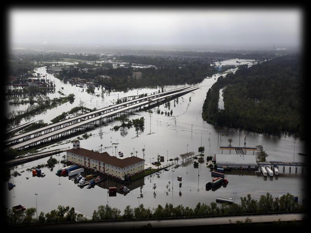
8 House of David and Kimberly King Waveland, Mississippi
9 Vulnerability Coastal areas are at increasing risk from sea-level rise and storm surge Rising sea-level provides a higher base for future surge/inundation events thus producing an increasing threat to: Coastal communities Ecosystems (wetlands, critical species, habitat loss, etc) Transportation systems (highway systems, ports, rail) Economic viability (tourism, transport of goods, natural resources) Energy
10

")
 Galveston,")
11 Gulf Coast Biloxi, Mississippi Katrina (2005) Key West, Florida Georges (1998) Laffite, Louisiana Rita (2005) Galveston, Texas Ike (2008)


12 Southeast Rodanthe, North Carolina Isabel (2003) Pawley s Island, South Carolina Hugo (1989) Jacksonville, Florida Fay (2008) North Hutchinson Island, Florida (Jeanne 2004)

 Hampton,")
")

13 Mid-Atlantic Baltimore, Maryland Isabel (2003) Hampton, Virginia Isabel (2003) Mantoloking, New Jersey Sandy (2012) Staten Island, New York (Sandy 2012)

 Westport,")
 Providence,")

14 New England Narragansett Bay, Rhode Island Carol (1954) Westport, Massachusetts Irene (2011) Providence, Rhode Island 1938 Hurricane East Haven, Connecticut Sandy (2012)

15 What is Storm Surge? STORM SURGE is an abnormal rise of water generated by a storm, over and above the predicted astronomical tide. STORM TIDE is the water level rise during a storm due to the combination of storm surge and the astronomical tide

16 Storm Surge from Hurricane Irene Rumley Marsh on the Pamlico River in North Carolina


17 Low Water from Hurricane Irene Pamlico Sound at Cape Hatteras, NC


18 Storm Surge from Tropical Storm Debby Bayshore Blvd., Tampa, FL


19 Storm Surge from Hurricane Isaac Pontchartrain Drive, Slidell, LA

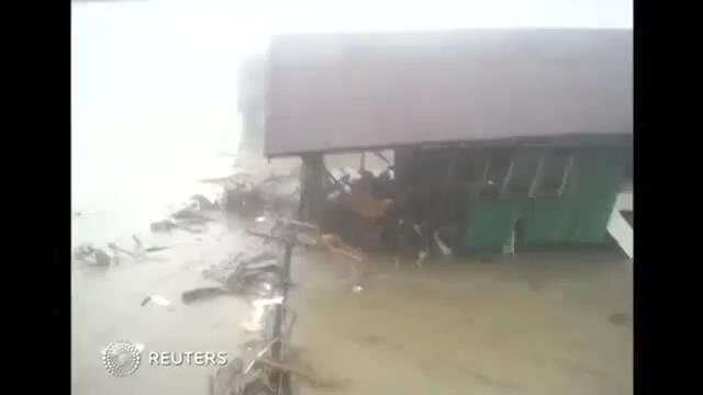
20 Typhoon Haiyan The Philippines

21 What about Waves? Breaking waves also contribute to the total water level through wave runup/setup WAVE RUNUP is the time-varying fluctuation of water-level elevation at the shoreline due to wave breaking WAVE SETUP is the time-averaged water level rise due to wave breaking The magnitude of both runup and setup are related to offshore wave period, wave height, and shelf slope

22 Wave Runup

23 Wave Setup


24 Galveston Day before Ike arrived


25 Freshwater Input River input, esp. into bays and sounds Mississippi River discharges 200, ,000 cubic feet per second Rainfall

26 Total Water Total Water Total water level = Storm surge + Tides + Wave setup + Freshwater

 KATRINA (3) IKE (2)")
27 No More Surge in the Saffir-Simpson Scale! (it fits like a square peg in a round hole) KATRINA (3) IKE (2) SANDY (1) ISAAC (1) CHARLEY (4)

28 No Such Thing as Just a Tropical Storm Louisiana State Rd. 23 near Myrtle Grove Tropical Storm Lee (2011)

29 Deep Water A B C Wind Wind Eye A B C 0 MSL 5O Current a. Top view of Sea Surface b. Side view of Cross Section ABC

30 Landfall A B C Eye Wind Wind STORM SURGE A B Current C MSL Mainland Barrier Island Continental Shelf a. Top view of sea surface and land b. Side view of Cross Section ABC
31 Understanding Surge
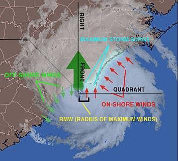
32 Factors Affecting Storm Surge Central Pressure Intensity (wind speed) Forward Speed Size Radius of Maximum Winds (RMW) Angle of Approach Width and Slope of Shelf Local features concavity of coastlines, bays, rivers, headlands, or islands

33 Effects of Low Pressure


34 Intensity (Wind Speed) 15 mph stronger

 25")
35 Forward Speed (Open Coast) 25 mph

36 Size (Radius of Max Winds)


37 Angle of Approach NNW NW Motion

38 Width and Slope of Shelf Wide shelf/ gentle slope Narrow shelf/ sharp slope


39 Start of shelf trapped wave up the Florida Coast
40
41
 Perishable Traditionally best")
 Relatively new method Deployed in advance of storm at expected location of highest surge Can contain")
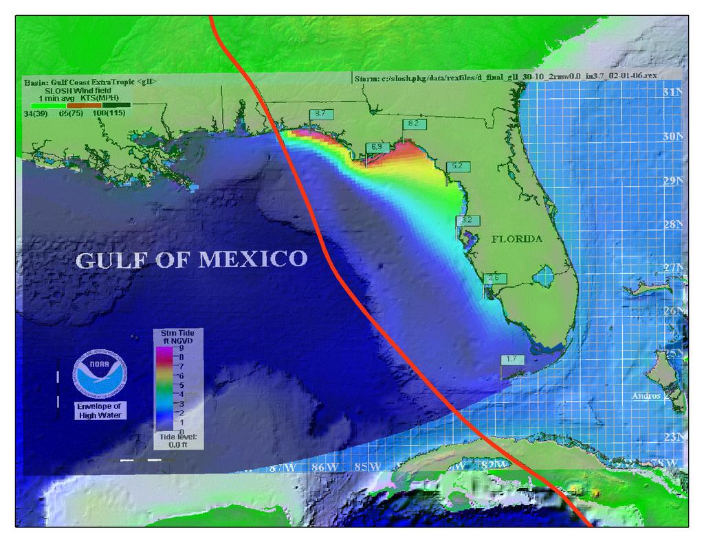
42 Observing and Measuring Storm Surge Tide stations (NOAA) Still water Traditionally most reliable Limited stations Stations often fail at height of event High water marks (FEMA/USGS) Perishable Traditionally best method for capturing highest surge Subjective and often include impacts of wave runup/setup Pressure Sensors (USGS) Relatively new method Deployed in advance of storm at expected location of highest surge Can contain effects of waves

43 High Water Mark Hoboken, New Jersey (Sandy)
44 Questions/Comments?
The Storm Surge Hazard 2018 TS-8 Tropical Meteorology 2
 The Storm Surge Hazard 2018 TS-8 Tropical Meteorology 2 Daniel Noah National Weather Service Tampa Bay daniel.noah@noaa.gov Tropical Cyclone Storm Surge Is a large dome of water, often 50 to 100 miles
UNDERSTANDING STORM SURGE
 The Education Program at the New Jersey Sea Grant Consortium 22 Magruder Road, Fort Hancock, NJ 07732 (732) 872-1300 www.njseagrant.org UNDERSTANDING STORM SURGE ACTIVITY 6 SURGE OF THE STORM http://secoora.org/classroom/virtual_hurricane/surge_of_the_storm>
SURGE SUPPRESSION ACHIEVED BY DIFFERENT COASTAL SPINE (IKE DIKE) ALIGNMENTS. Bruce A. Ebersole, Thomas W. Richardson and Robert W.
 ALIGNMENTS. Bruce A. Ebersole, Thomas W. Richardson and Robert W.") SURGE SUPPRESSION ACHIEVED BY DIFFERENT COASTAL SPINE (IKE DIKE) ALIGNMENTS Abstract Bruce A. Ebersole, Thomas W. Richardson and Robert W. Whalin, Jackson State University, Jackson, Mississippi The primary
SURGE SUPPRESSION ACHIEVED BY DIFFERENT COASTAL SPINE (IKE DIKE) ALIGNMENTS Abstract Bruce A. Ebersole, Thomas W. Richardson and Robert W. Whalin, Jackson State University, Jackson, Mississippi The primary
NYS Coastal Waters. Water Resources of NYS: THE NATURE of the COASTAL ZONE. NYS Coastal Waters. NYS Coastal Atlas. Coastal Zone Management 10/10/2014
 Water Resources of NYS: THE NATURE of the COASTAL ZONE NYS Coastal Waters NYS is the only state to border the Atlantic Ocean and the Great Lakes (Lakes Erie and Ontario). Great Lakes shoreline: 577 miles
US Beach Nourishment Experience:
 Beach Nourishment: Introduction of new sand to the beach by truck or dredge Large beach >1 million cubic yards (100,000 dump truck loads) Funding is a combination of federal, state, local & private Also
Chapter 15 SEASONAL CHANGES IN BEACHES OP THE NORTH ATLANTIC COAST OF THE UNITED STATES
 Chapter 15 SEASONAL CHANGES IN BEACHES OP THE NORTH ATLANTIC COAST OF THE UNITED STATES By John M. Darling Hydraulic Engineer, Research Division U. S. Army Coastal Engineering Research Center Corps of
Under the Boardwalk: Coastal Geomorphology
 Under the Boardwalk: Coastal Geomorphology What to look for while you're on the beach during spring break. What Causes Changes in Sea Level? Answer Varies with Time Scale. Long-Term Changes in Sea Level
GONE! Coastal Erosion Happens During Storms! Why Worry About Coastal Setbacks? Goals for Today
 RI Regulatory Setbacks & Buffers: Coastal Zone Management Issues New England Onsite Wastewater Training Program @ URI OWT 155 November 21, 2013 Goals for Today Understand the impacts of storms, coastal
Coastal management has lagged behind the growth in population leading to problems with pollution
 Fifty percent of the population of the industrialized world lives within 100 km of a coast. Coastal management has lagged behind the growth in population leading to problems with pollution and natural
Overview. Beach Features. Coastal Regions. Other Beach Profile Features. CHAPTER 10 The Coast: Beaches and Shoreline Processes.
 Overview CHAPTER 10 The Coast: Beaches and Shoreline Processes Coastal regions constantly change. The beach is a dominant coastal feature. Wave activity continually modifies the beach and coastal areas.
Environmental Geology Chapter 11 COASTAL PROCESSES and RELATED HAZARDS
 Environmental Geology Chapter 11 COASTAL PROCESSES and RELATED HAZARDS Introduction >50% of world population concentrated in the coastal zones ~75% of U.S. population living in coastal states Coastal hazard
RI Regulatory Setbacks & Buffers: Coastal Management Issues
 RI Regulatory Setbacks & Buffers: Coastal Management Issues New England Onsite Wastewater Training Program @ URI OWT 155 - November 29, 2012 James Boyd - Coastal Policy Analyst Photo: October 30, 2012
Advancing the Gulf of Mexico Shellfish Initiative (GoMexSI)
") Advancing the Gulf of Mexico Shellfish Initiative (GoMexSI) Gulf States Marine Fisheries Commission Mississippi-Alabama Sea Grant Consortium Gulf States Marine Fisheries Commission Annual Meeting March
Advancing the Gulf of Mexico Shellfish Initiative (GoMexSI) Gulf States Marine Fisheries Commission Mississippi-Alabama Sea Grant Consortium Gulf States Marine Fisheries Commission Annual Meeting March
GEOLOGY 101 Under the Boardwalk: Coastal Geomorphology
 GEOLOGY 101 Under the Boardwalk: Coastal Geomorphology What to look for while you're on the beach during spring break. J.S. Kite, WVU What Causes Changes in Sea Level? Answer Varies with Time Scale. Long-Term
The Surge of the Storm By Margaret Olsen and Katie Greganti
 The Surge of the Storm By Margaret Olsen and Katie Greganti Grade Level: 5-12 Type of Activity: Hands on Focus Question: How does a hurricane s storm surge of a hurricane affect the low-lying areas along
COASTAL HAZARDS. What are Coastal Hazards?
 COASTAL HAZARDS What are Coastal Hazards? Hazards in the New Jersey coastal zone include unavoidable risks to life and property generated by: coastal flooding, waves, high winds and waves, short-term and
4/20/17. #30 - Coastlines - General Principles Coastlines - Overview
 Writing Assignment Due one week from today by 11:59 pm See main class web pages for detailed instructions Essays will be submitted in Illinois Compass (instructions later) Pick one: Earthquakes, tsunamis,
3/9/2013. Build house on cliff for a view of the ocean - be one with said view Pearson Education, Inc. Shorelines: summary in haiku form
 Introduction to Environmental Geology, 5e Edward A. Keller Shorelines: summary in haiku form Chapter 11 Coastal Processes Lecture Presentation prepared by X. Mara Chen, Salisbury University Build house
CHAPTER 6 Air-Sea Interaction
 CHAPTER 6 Air-Sea Interaction What causes Earth s seasons? Tilt (23.5 ) responsible for seasons 2011 Pearson Education, Inc. Distribution of Solar Energy Distribution of Solar Energy Atmosphere absorbs
Modeling Sediment Transport Along the Upper Texas Coast
 Modeling Sediment Transport Along the Upper Texas Coast David B. King Jr. Jeffery P. Waters William R. Curtis Highway 87 roadbed, Jefferson County Galveston District Corps Sabine Pass to San Luis Pass
The Case of the Disappearing Shoreline
 Name The Case of the Disappearing Shoreline Humans change the earth's climate in many ways. One change is the increase of carbon dioxide in the atmosphere. As we burn more fossil fuels, we release more
Shorelines Earth - Chapter 20 Stan Hatfield Southwestern Illinois College
 Shorelines Earth - Chapter 20 Stan Hatfield Southwestern Illinois College The Shoreline A Dynamic Interface The shoreline is a dynamic interface (common boundary) among air, land, and the ocean. The shoreline
Shorelines Earth Chapter 20 Chapter 20 Shorelines The Shoreline: A Dynamic Interface Cape Cod and Point Reyes Hurricane Sandy
 1 2 3 4 5 6 7 8 9 10 11 12 13 Shorelines Earth Chapter 20 Chapter 20 Shorelines The Shoreline: A Dynamic Interface The interface is the common boundary where different parts of a system interact. The Coastal
Unit VI Detecting Coastal Change with Lasers. Modern Coastal Studies
 Unit VI Detecting Coastal Change with Lasers On the cutting edge Barrier Islands provide natural protection against the destructive wind, waves, and tides that wash the shores of coastal communities. As
Chapter 20 Lecture. Earth: An Introduction to Physical Geology. Eleventh Edition. Shorelines. Tarbuck and Lutgens Pearson Education, Inc.
 Chapter 20 Lecture Earth: An Introduction to Physical Geology Eleventh Edition Shorelines Tarbuck and Lutgens The Shoreline: A Dynamic Interface The Coastal Zone The shoreline is constantly modified by
Texas passes, longshore transport, hurricanes, beach erosion and sea level
 Texas passes, longshore transport, hurricanes, beach erosion and sea level Richard L. Watson, Ph.D. (361) 749-4152 Field work can be strange! 120,000 years of sea level Years each zone exposed above S/L
Boothbay Harbor Rotary Club May 12, 2016
 Mapping Potential Sea Level Rise and Storm Surge in Boothbay Harbor, ME Boothbay Harbor Rotary Club May 12, 2016 Peter A. Slovinsky, Marine Geologist Maine Geological Survey S.M. Dickson, MGS Quickly,
DELAWARE S VULNERABLE COASTAL AREAS. DELAWARE INLAND BAYS and DELAWARE BAY RECONNAISSANCE STUDY
 DELAWARE S VULNERABLE COASTAL AREAS and the DELAWARE INLAND BAYS and DELAWARE BAY RECONNAISSANCE STUDY Kimberly K. McKenna, PG Delaware Dept. of Natural Resources & Environmental Control Division of Watershed
CALCASIEU SALINITY STRUCTURES. HYDRODYNAMIC MODELING (To Support Design of Salinity Barriers)
") CALCASIEU SALINITY STRUCTURES HYDRODYNAMIC MODELING (To Support Design of Salinity Barriers) Presentation Overview 1 2 3 4 5 Project Overview and CEA Circulation Modeling Vessel Hydrodynamics Modeling
CALCASIEU SALINITY STRUCTURES HYDRODYNAMIC MODELING (To Support Design of Salinity Barriers) Presentation Overview 1 2 3 4 5 Project Overview and CEA Circulation Modeling Vessel Hydrodynamics Modeling
City of Del Mar Local Coastal Plan (LCP) Amendment for Sea Level Rise and Coastal Flooding
 Amendment for Sea Level Rise and Coastal Flooding") City of Del Mar Local Coastal Plan (LCP) Amendment for Sea Level Rise and Coastal Flooding 6/22/17 Presentation to Sea Level Rise Stakeholder- Technical Advisory Committee (STAC) Nick Garrity, P.E. Lindsey
City of Del Mar Local Coastal Plan (LCP) Amendment for Sea Level Rise and Coastal Flooding 6/22/17 Presentation to Sea Level Rise Stakeholder- Technical Advisory Committee (STAC) Nick Garrity, P.E. Lindsey
Hurricane Rita Impacts on the Texas Shoreline A Summary Report
 Hurricane Rita Impacts on the Texas Shoreline A Summary Report James Gibeaut, Tiffany Hepner, John Andrews, Roberto Gutierrez, and Becky Smyth Prepared for the Texas General Land Office under GLO Interagency
4/20/17. #31 - Coastal Erosion. Coastal Erosion - Overview
 Writing Assignment Due Monday by 11:59 pm #31 - Coastal Erosion Beach front property! Great View! Buy now at a great price! See main class web pages for detailed instructions Essays will be submitted in
Marginal Marine Environments
 Marginal Marine Environments Delta: discrete shoreline protuberances formed where rivers enter oceans, semi-enclosed seas, lakes or lagoons and supply sediment more rapidly than it can be redistributed
Climate Change Impacts to KSC Launch Complex
 Climate Change Impacts to KSC Launch Complex Presented to: 2010 International Workshop on Environment and Energy By: John Shaffer NASA Environmental Management Branch Kennedy Space Center Hurricane Season
COMMUNITY WATERSHED PROJECT
 SABINE RED RIVER COMMUNITY WATERSHED PROJECT A Watershed Approach to Aquatic Resources Do you have a stake in the water, the wildlife, the use of the land? Help us do for fish what was done for ducks*.
Catch The SEACOOS Wave!
 Catch The SEACOOS Wave! Lundie Spence, Terri Hathaway, Margaret Olsen, Maia McGuire, Carrie Thomas, Jennifer Jolly Clair Presentation National Marine Educators Association July 20, 2004 Why are we interested
consulting engineers and scientists
 consulting engineers and scientists Coastal Processes Presented by: January 9, 2015 Varoujan Hagopian, P.E. F.ASCE Senior Consultant, Waterfront Engineer Living Shoreline Workshop Lets Remember Why We
Dune Monitoring Data Update Summary: 2013
 Dune Monitoring Data Update Summary: 13 Shoreline Studies Program Virginia Institute of Marine Science College of William & Mary Gloucester Point, Virginia September 13 Dune Monitoring Data Update Summary:
Definitions. The environment is the biological, chemical, physical, and social conditions that surround organisms.
 Marine Ecosystems Definitions An ecosystem is a geographically specified system of organisms (including humans), the environment, and the processes that control its dynamics. The environment is the biological,
Coastal issues: Beaches and Estuaries. Recent Sea Level: Beaches: Baltimore D.C. Patomac R. Chesapeake Bay
 Coastal issues: Beaches and Estuaries Definitions: Coast = broad zone where both marine & terrestrial processes act It includes the beach, lagoons, marshes, bars etc. Coastal processes act to shape the
Shore - place where ocean meets land Coast - refers to the larger zone affected by the processes that occur at this boundary.
 Waves, Beaches, and Coasts Shore - place where ocean meets land Coast - refers to the larger zone affected by the processes that occur at this boundary. Waves: energy moving through water The height of
Ivan-like hurricane storm surge simulations for Tampa Bay, FL with 3-D and 2-D models
 Ivan-like hurricane storm surge simulations for Tampa Bay, FL with 3-D and 2-D models R.H. Weisberg and L. Zheng Storm Surge Workshop St. Pete Beach 2/11/09 Potential for Tampa Bay area inundation is large
Essential Fish Habitat Description Atlantic cod (Gadus morhua)
") Description Atlantic cod (Gadus morhua) In its Report to Congress: Status of the Fisheries of the United States (September 1997), NMFS determined the Gulf of Maine stock of cod is considered overfished,
Description Atlantic cod (Gadus morhua) In its Report to Congress: Status of the Fisheries of the United States (September 1997), NMFS determined the Gulf of Maine stock of cod is considered overfished,
Atmospheric Circulation. Density of Air. Density of Air: H 2 O and Pressure effects
 Today s topics: Atmospheric circulation: generation of wind patterns on a rotating Earth Seasonal patterns of climate: Monsoons and Sea Breezes Tropical Cyclones: Hurricanes and typhoons Atmospheric Circulation
The Dynamic Coast. Right Place Resources. A presentation about the interaction between the dynamic coast and people
 The Dynamic Coast Houses threatened by coastal erosion in California Right Place Resources A presentation about the interaction between the dynamic coast and people For the rest of the presentations in
REDUCTION OF HURRICANE IMPACT BY RE-CREATION OF MARSHLANDS AND BARRIER ISLANDS
 REDUCTION OF HURRICANE IMPACT BY RE-CREATION OF MARSHLANDS AND BARRIER ISLANDS C.J. Otten 1 and P. Bakker 2 ABSTRACT Hurricanes pose a serious threat to existence along a large part of the American coastline.
Coastal Hazards and Management in North Carolina. Braxton Davis April 14, 2015
 Coastal Hazards and Management in North Carolina Braxton Davis April 14, 2015 Coastal Facts and Figures 320 miles of ocean beaches 12,000+ miles of estuarine shoreline 2 million + acres of sounds, creeks,
Essentials of Oceanography Eleventh Edition
 Chapter Chapter 1 10 Clickers Lecture Essentials of Oceanography Eleventh Edition The Coast: Beaches and Shoreline Processes Alan P. Trujillo Harold V. Thurman Chapter Overview Coastal regions have distinct
Survival in an Estuary. Life in a Transition Zone
 Estuary An estuary is a semi-enclosed coastal body of water which has a free connection with the open sea and within which sea water is measurably diluted with fresh water derived from land drainage. (D.
COASTAL MORPHODYNAMICS
 COASTAL MORPHODYNAMICS PATRICIA CHARDÓN-MALDONADO, PHD, EIT Miguel Canals, Jack A. Puleo, Alec Torres-Freyermuth & Jens Figlus March 9, 2017 OUTLINE INTRODUCTION Meteorological Phenomena Forcing Conditions
Unit 11 Lesson 2 How Does Ocean Water Move? Copyright Houghton Mifflin Harcourt Publishing Company
 Unit 11 Lesson 2 How Does Ocean Water Move? Catch a Wave A wave is the up-and-down movement of surface water. Catch a Wave Catch a Wave (wave effects) Surface waves are caused by wind pushing against
Town of Duck, North Carolina
 Tracking No. 00.00.2010 Erosion Mitigation And Shoreline Management Feasibility Study Town of Duck, North Carolina Coastal Planning & Engineering of North Carolina February 28, 2013 Ken Willson 1 Tracking
EMERGENCY PREPAREDNESS PARTNERSHIP LOUISIANA CONTRAFLOW OPERATIONS BRIEFING
 EMERGENCY PREPAREDNESS PARTNERSHIP LOUISIANA CONTRAFLOW OPERATIONS BRIEFING NEW CONTRAFLOW PLAN SITUATION 2 million people at risk in Southeast Louisiana 1.2 million in New Orleans Metro area alone Very
Biological Review of the 2014 Texas Closure
 Biological Review of the 2014 Texas Closure Report to the Gulf of Mexico Fishery Management Council by James M. Nance, Ph.D. Southeast Fisheries Science Center Galveston Laboratory January 2015 Introduction
Oceans and Coasts. Chapter 18
 Oceans and Coasts Chapter 18 Exploring the oceans The ocean floor Sediments thicken and the age of the seafloor increases from ridge to shore The continental shelf off the northeast United States Constituent
WEATHER SYSTEMS OF MIDDLE LATITUDES
 CHAPTER 10 WEATHER SYSTEMS OF MIDDLE LATITUDES MULTIPLE CHOICE QUESTIONS 1. In equal volumes, which one of the following air masses exerts the highest surface air pressure? a. cp *b. A c. mp d. ct e. mt
The History of Coastal Flood Hazard Assessments in the Great Lakes
 The History of Coastal Flood Hazard Assessments in the Great Lakes Brian A. Caufield, P.E., CFM June 23, 2016 2 The Great Lakes Some Statistics Courtesy of Great Lakes Information Network One-fifth of
Atmospheric Circulation (Ch. 8) Ocean & Atmosphere are intertwined Gases & waters freely exchanged Wind Weather Climate
 Ocean & Atmosphere are intertwined Gases & waters freely exchanged Wind Weather Climate") Atmospheric Circulation (Ch. 8) Ocean & Atmosphere are intertwined Gases & waters freely exchanged Wind Weather Climate Atmospheric Structure Consists of Layers Separated by Temperature Stratosphere: Temperature
Atmospheric Circulation (Ch. 8) Ocean & Atmosphere are intertwined Gases & waters freely exchanged Wind Weather Climate Atmospheric Structure Consists of Layers Separated by Temperature Stratosphere: Temperature
G. Meadows, H. Purcell and L. Meadows University of Michigan
 www.coj.net/departments/fire+and+rescue/emergency+preparedness/rip+current.htm G. Meadows, H. Purcell and L. Meadows Over 80% of all surf related rescues are attributable to Rip Currents According to the
HURRICANE NATE BRIEFING
 HURRICANE NATE BRIEFING 11:00 PM CDT Friday, October 6, 2017 Prepared by: NWS NWSNewOrleans www.weather.gov/neworleans Situation Overview Nate is now a hurricane with no significant change in the track
Cyclone Hazards: waves and storm tide
 Cyclone Hazards: waves and storm tide 1/32 HIGH WAVES TORRENTIAL RAIN (FLOODING) SURGE ON COAST AT CROSSING GALE FORCE WINDS 2/32 Waves and Swell MetEd Comet Program Wind and Wave forecasting https://www.meted.ucar.edu/training_course.php?id=8
BEACH PROCESSES AND COASTAL ENVIRONMENTS
 BEACH PROCESSES AND COASTAL ENVIRONMENTS COASTAL FEATURES Cross section Map view TOPICS: Terminology Waves Beach Morphology Barriers Coastal Migration Tides Tidal Flats and Marshes Sediment Budgets Human
Environmental Protection on the Gold Coast of Queensland, Australia. 1. What is the appeal of the Gold Coast to tourists?
 Environmental Protection on the Gold Coast of Queensland, Australia Sections 1. What is the appeal of the Gold Coast to tourists? 2. How are Gold Coast visitor trends changing? 3. How can the impacts of
Implications of changes to El Niño Southern Oscillation for coastal vulnerability in NSW
 Implications of changes to El Niño Southern Oscillation for coastal vulnerability in NSW By Thomas Mortlock (Thomas.mortlock@mq.edu.au) El Niño Southern Oscillation (ENSO) has a strong impact on weather
LEARNING FROM SANDY Webinar 2. Lessons learned. March 12, Beth A. Leonard Director of Technical Services BoatU.S.
 LEARNING FROM SANDY Webinar 2 Lessons learned March 12, 2013 Beth A. Leonard Director of Technical Services BoatU.S. Association of Marina Industries (AMI) Website: http://marinaassociation.org/ Contact:
HURRICANE NATE BRIEFING
 HURRICANE NATE BRIEFING 5:00 AM CDT Saturday, October 7, 2017 Prepared by: NWS NWSNewOrleans www.weather.gov/neworleans Situation Overview Nate is now a hurricane with no significant change in the track
VIDEO TRANSCRIPT. A Proposal to Expand the Flower Garden Banks National Marine Sanctuary An interview with Sanctuary Superintendent, G.P.
 VIDEO TRANSCRIPT A Proposal to Expand the Flower Garden Banks National Marine Sanctuary An interview with Sanctuary Superintendent, G.P. Schmahl (Opening scene of Flower Garden Banks National Marine Sanctuary
Louisiana s 2012 Coastal Master Plan BARRIER SHORELINE MORPHOLOGY MODEL
 Louisiana Coastal Protection & Restorat coastal.louisiana.gov Louisiana s 2012 Coastal Master Plan PREDICTIVE MODELING: committed to our coast BARRIER SHORELINE MORPHOLOGY MODEL Dallon Weathers, University
/50. Physical Geology Shorelines
 Physical Geology Shorelines Multiple Guess: (You know the drill 2 points each) 1. The path of movement of a water particle in a wave at sea is 1. circular 2. horizontal 3. vertical 4. elliptical 5. none
2016 NC Coastal Local Governments Annual Meeting
 2016 NC Coastal Local Governments Annual Meeting Coastal Flood Study Modeling and Mapping 101 April 21, 2016 Tom Langan, PE, CFM Engineering Supervisor NCEM Floodplain Mapping Program FEMA Coastal Flood
Evaluation of June 9, 2014 Federal Emergency Management Agency Flood Insurance Study for Town of Weymouth, Norfolk, Co, MA
 Evaluation of June 9, 2014 Federal Emergency Management Agency Flood Insurance Study for Town of Weymouth, Norfolk, Co, MA Prepared For: Woodard & Curran 95 Cedar Street, Suite 100 Providence, RI 02903
A. SOUTHERN NEW ENGLAND / MID-ATLANTIC (SNE/MA) WINTER FLOUNDER ASSESSMENT SUMMARY FOR 2011
 WINTER FLOUNDER ASSESSMENT SUMMARY FOR 2011") A. SOUTHERN NEW ENGLAND / MID-ATLANTIC (SNE/MA) WINTER FLOUNDER ASSESSMENT SUMMARY FOR 2011 State of Stock: In 2010 the SNE/MA winter flounder stock was overfished but overfishing was not occurring. The
A. SOUTHERN NEW ENGLAND / MID-ATLANTIC (SNE/MA) WINTER FLOUNDER ASSESSMENT SUMMARY FOR 2011 State of Stock: In 2010 the SNE/MA winter flounder stock was overfished but overfishing was not occurring. The
ST. LUCIE COUNTY, FLORIDA
 ST. LUCIE COUNTY, FLORIDA COASTAL STORM RISK MANAGEMENT STUDY Draft Feasibility Study & Integrated Environmental Assessment Public Meeting Presented by U.S. Army Corps of Engineers Jacksonville District
Climate Change and Security:
 Climate Change and Security: Ideas & Inspiration from Annapolis Angela Schedel, CDR, U.S. Navy Assistant Professor, U.S. Naval Academy Presented on September 13, 2016 at USFSP icar Workshop Disclaimer
Gulf of Mexico Region Fisheries Extension Enhancement Review
 Gulf of Mexico Region Fisheries Extension Enhancement Review Rex H. Caffey Louisiana Sea Grant College Program Center for Natural Resource Economics & Policy FEE in the Gulf of Mexico Region 1) Programming
THE ROLE OF NATURE: UNDERSTANDING HOW NATURAL FEATURES CONTRIBUTE TO COASTAL RISK REDUCTION. Denise Reed, Chief Scientist
 THE ROLE OF NATURE: UNDERSTANDING HOW NATURAL FEATURES CONTRIBUTE TO COASTAL RISK REDUCTION Denise Reed, Chief Scientist The Water Institute of the Gulf is a not-for-profit, independent research institute
Chapter 10 Lecture Outline. The Restless Oceans
 Chapter 10 Lecture Outline The Restless Oceans Focus Question 10.1 How does the Coriolis effect influence ocean currents? The Ocean s Surface Circulation Ocean currents Masses of water that flow from one
The Sand Beaches of New Hampshire and Maine
 The Sand Beaches of New Hampshire and Maine Beach Preservation and Erosion Control Photographs provided by Joe Kelly and Steve Adams Cover photo: Reid State Park, ME Introduction The sand beaches of New
Announcements. Why does the wind blow? What makes the ocean flow? Pressure gradients and Coriolis. First assignment (deep-sea sediments)
") Announcements First assignment (deep-sea sediments) I expect to be finished grading exams in two weeks. Second problem set due November 7th New topic: Physics of atmospheric and oceanic circulation Atmospheric
Announcements First assignment (deep-sea sediments) I expect to be finished grading exams in two weeks. Second problem set due November 7th New topic: Physics of atmospheric and oceanic circulation Atmospheric
Project Webpage:
 Project Webpage: http://nature.ly/marinesatlanticbightera Coastal Data and Full Metadata: http://easterndivision.s3.amazonaws.com/marine/sab MA/SABMACoastalEcosystems.zip Coastal Chapter: http://easterndivision.s3.amazonaws.com/marine/sab
Beach Restoration in Okaloosa and Walton Counties. FSBPA Technology Conference Clearwater, FL
 Beach Restoration in Okaloosa and Walton Counties FSBPA Technology Conference Clearwater, FL Presented by: Duncan Greer, E.I. February 5, 2015 PRESENTATION OUTLINE 1. Overview of Project Locations 2. Eglin
Coastal Change and Conflict
 Coastal Change and Conflict Outline of the Topic Contrasting Coasts why do all coasts not look the same? Geology of the coast the impact rock structure has on the coastline Waves Constructive and destructive
New Jersey Coastal Zone Overview. The New Jersey Beach Profile Network (NJBPN) 3 Dimensional Assessments. Quantifying Shoreline Migration
 3 Dimensional Assessments. Quantifying Shoreline Migration") New Jersey Coastal Zone Overview The New Jersey Beach Profile Network (NJBPN) Objectives Profile Locations Data Collection Analyzing NJBPN Data Examples 3 Dimensional Assessments Methodology Examples Quantifying
New Jersey Coastal Zone Overview The New Jersey Beach Profile Network (NJBPN) Objectives Profile Locations Data Collection Analyzing NJBPN Data Examples 3 Dimensional Assessments Methodology Examples Quantifying
Office of Science & Technology
 NOAA Fisheries Highlights of FEUS 2015 Highlights from the Annual Report Fisheries Economics of the United States, 2015 Office of Science & Technology Fisheries and the Economy U.S. fisheries provide jobs,
page - Laboratory Exercise #5 Shoreline Processes
 page - Laboratory Exercise #5 Shoreline Processes Section A Shoreline Processes: Overview of Waves The ocean s surface is influenced by three types of motion (waves, tides and surface currents). Shorelines
Chesil Beach, Dorset UK High energy, shingle coastline. Brighton Beach, Sussex UK Pebble beach
 Beaches: Depositional landform Extends from the highest high tide to the lowest low tide. Very important temporary store in coastal system. Accretion: sediment returning to the visible portion of a beach
Types of Estuaries and Mixing Patterns. Mrs. Stahl Marine Science Honors
 Types of Estuaries and Mixing Patterns Mrs. Stahl Marine Science Honors Coastal Plain Form between glacial periods, when water from melting glaciers raises the sea level and floods coastal plains and low
Atmospheric Circulation. Recall Vertical Circulation
 Today s topics: Atmospheric circulation: generation of wind patterns on a rotating Earth Seasonal patterns of climate: Monsoons and Sea Breezes Tropical Cyclones: Hurricanes and typhoons Atmospheric Circulation
Impact of Hurricane Matthew on the Atlantic Coast of Florida
 Impact of Hurricane Matthew on the Atlantic Coast of Florida A coastal engineer was driving across country and his jeep broke down in front of a monastery. It was late in the day and the monks invited
UPPER BEACH REPLENISHMENT PROJECT RELATED
 ASSESSMENT OF SAND VOLUME LOSS at the TOWNSHIP of UPPER BEACH REPLENISHMENT PROJECT RELATED to the LANDFALL OF HURRICANE SANDY - PURSUANT TO NJ-DR 4086 This assessment is in response to Hurricane Sandy
Monitoring Morphology and Currents at the Hatteras Breach
 Monitoring Morphology and Currents at the Hatteras Breach By Ty V. Wamsley U.S. Army Engineering Research and Development Center Coastal and Hydraulics Laboratory 3909 Halls Ferry Road, Vicksburg, MS 39180
Fish Habitat and the Mid-Atlantic Fishery Management Council
 Fish Habitat and the Mid-Atlantic Fishery Management Council Jessica Coakley June 19, 2017 Today Council s habitat interests (evolution) Essential Fish Habitat Redo progress Mid-Atlantic fish habitat assessment
Lecture Outlines PowerPoint. Chapter 15 Earth Science, 12e Tarbuck/Lutgens
 Lecture Outlines PowerPoint Chapter 15 Earth Science, 12e Tarbuck/Lutgens 2009 Pearson Prentice Hall This work is protected by United States copyright laws and is provided solely for the use of instructors
MESSOLOGI LAGOON AREA (GREECE)
") MESSOLOGI LAGOON AREA (GREECE) 20 Contact: Kyriakos SPYROPOULOS TRITON Consulting Engineers 90 Pratinou Str. 11634 Athens (GREECE) Tel: +32 10 729 57 61 Fax: +32 10 724 33 58 e-mail: kspyropoulos@tritonsa.gr
MESSOLOGI LAGOON AREA (GREECE) 20 Contact: Kyriakos SPYROPOULOS TRITON Consulting Engineers 90 Pratinou Str. 11634 Athens (GREECE) Tel: +32 10 729 57 61 Fax: +32 10 724 33 58 e-mail: kspyropoulos@tritonsa.gr
Important note To cite this publication, please use the final published version (if applicable). Please check the document version above.
. Please check the document version above.") Delft University of Technology Galveston Bay Area Land Barrier preliminary design van Berchum, Erik; de Vries, P.A.L.; de Kort, R.P.J. Publication date 2016 Document Version Publisher's PDF, also known
Delft University of Technology Galveston Bay Area Land Barrier preliminary design van Berchum, Erik; de Vries, P.A.L.; de Kort, R.P.J. Publication date 2016 Document Version Publisher's PDF, also known
2013 FEDERAL STORM RESPONSE
 2013 FEDERAL STORM Presented to the Florida Shore & Beach Association Sep 26, 2013 Presented by: COL Alan Dodd Commander, Jacksonville District September 2013 THE COLLABORATION 2 THE PROGRAM 3 THE STORMS
Hydrologic Feasibility of Storm Surge Barriers
 Hydrologic Feasibility of Storm Surge Barriers Malcolm J. Bowman, School of Marine and Atmospheric Sciences State University of New York, Stony Brook, NY. Presented at Against the Deluge: Storm Surge Barriers
LAKKOPETRA (GREECE) EUROSION Case Study. Contact: Kyriakos SPYROPOULOS. TRITON Consulting Engineers. 90 Pratinou Str Athens (GREECE)
 EUROSION Case Study. Contact: Kyriakos SPYROPOULOS. TRITON Consulting Engineers. 90 Pratinou Str Athens (GREECE)") LAKKOPETRA (GREECE) Contact: Kyriakos SPYROPOULOS TRITON Consulting Engineers 90 Pratinou Str. 11634 Athens (GREECE) Tel: +32 10 729 57 61 Fax: +32 10 724 33 58 e-mail: kspyropoulos@tritonsa.gr 19 1 1.
LAKKOPETRA (GREECE) Contact: Kyriakos SPYROPOULOS TRITON Consulting Engineers 90 Pratinou Str. 11634 Athens (GREECE) Tel: +32 10 729 57 61 Fax: +32 10 724 33 58 e-mail: kspyropoulos@tritonsa.gr 19 1 1.
Time Dependent Wave Setup During Hurricanes on the Mississippi Coast. D. Slinn, A. Niedoroda,, R. Dean, R. Weaver, C. Reed, and J. Smith.
 Time Dependent Wave Setup During Hurricanes on the Mississippi Coast D. Slinn, A. Niedoroda,, R. Dean, R. Weaver, C. Reed, and J. Smith. 1 Motivation TO UNDERSTAND THE APPARENT DIFFERENCE IN WAVE SET-UP
Today: Coastal Issues and Estuaries
 Today: Coastal Issues and Estuaries Coastal issues Human effect on coastlines What is an estuary Why are they so important? Circulation of water in estuary Environmental issues Coastal Issues: Problem