Door County, WI Coastal Hazard Analysis Flood Risk Review Meeting. August 21, 2017
|
|
|
- Elisabeth O’Neal’
- 6 years ago
- Views:
Transcription
1 Door County, WI Coastal Hazard Analysis Flood Risk Review Meeting August 21, 2017
2 Agenda Introductions Coastal Flood Risk Study and Mapping Program Current Status Technical Overview of Study and Mapping Floodplain Management Next Steps Q&A Work map Review 2
3 Door County, WI COASTAL FLOOD RISK STUDY AND MAPPING PROGRAM 3


4 Great Lakes Flood Study Comprehensive study of the Coastal Great Lakes flood hazards Latest technology, data, and models including response based modelling concepts Partners involved: 4
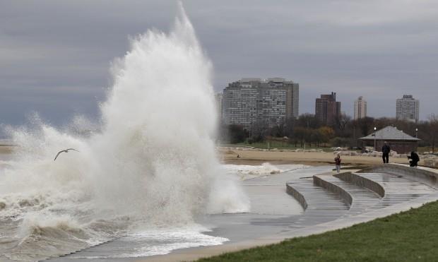
5 Response-Based Wave Runup Wave runup is the uprush of water from wave action on a beach, steep bluff or coastal structure. Calculated at each transect using appropriate hydrodynamic equations that simulate events for every time step captured for selected storms using lake-wide gridded record (ADCIRC-SWAN) Statistical analysis is performed on the maximum runup results at each transect to obtain the 1-percent-annual-chance runup elevation. 5

")
6 Response-Based Wave Runup Door Transect 16 Wave Height SWEL (including wave setup) Ground profile 6


7 FEMA s Risk MAP Program Risk Mapping, Assessment, and Planning Will deliver quality data to increase public awareness and lead to action that reduces risk to life and property New non-regulatory products and datasets Mapping Assessment Planning 7


8 Mitigation Actions: A Shared Responsibility STRUCTURE AND INFRASTRUCTURE PROJECTS Acquisition Elevation Revetments and Seawalls Breakwater LOCAL PLAN AND REGULATIONS Zoning Building Codes Open Space Plan Lake Front Development Master Plan CITIZEN AND BUSINESS ENGAGEMENT Firewise StormReady NFIP and CRS NATURAL SYSTEM PROTECTION Vegetation management Wetland restoration Erosion control 8
9 Door County, WI CURRENT STATUS REVIEW 9


10 Analyses/Mapping: Grouping Wisconsin: Phase 3 Door Brown Oconto Marinette FRR Meetings fall at the end of a multi-year study including sophisticated modeling Next, the maps and data will be put into the official regulatory format 10
11 Current Study Status Lake-Wide Storm Surge and Waves Study County Based Wave Runup, Overtopping, and Overland Analyses You are here Workmap Production Comment Period FIRM Production Preliminary FIRM Community Coordination Meeting Comment and Appeal Periods Letter of Final Determination Effective FIRM 11

12 Work Map Data Viewer Link to the Door, WI Work Map Data Viewer: 12

13 Work Map Data Viewer 13

14 Work Map Data Viewer 14
15 Door County, WI TECHNICAL OVERVIEW OF STUDY AND MAPPING 15
16 Coastal Flood Hazard Modeling Overview Lake-Wide Variation Step 1: Offshore Water Level and Wave Modeling Local Variation Step 2: Nearshore Wave Setup, Runup & Overtopping Step 3: Floodplain Mapping 16
17 Run-up Methods Approach for Upper Lakes numerical modeling 17


18 Step 1: ADCIRC+SWAN Mesh Resolution as Fine as 10 m Along Complex Shoreline Features including Jetties, Breakwaters, Inlets, and Natural Shoals 18


19 Step 1: Run the Models Baseline Meteorological Forcing Physical Setting Waves Wind Ice Bathymetry Water Level Pressure Still Water Elevations Total of 150 events between

20 Step 1: Lake Levels 20
21 Step 1: Lake Levels 21
22 Step 1: Lake Levels 22

23 Step 1: Example Surge Behavior 23

24 Step 1: Water Level Accuracy Assessment 24
25 Step 2: Nearshore Wave-Induced Flood Hazards Nearshore Wave-Induced Flood Hazards Analysis includes: Shoreline classification 2-D Wave and Surge Model data extraction Wave setup Erosion Evaluation of coastal structures Wave runup Wave overtopping Overland wave propagation Statistical analysis Along 1-D Transects 25


26 Step 2: Transect Layout Door County 105 transects 67 panels 26


27 Step 2: Transect Analysis Overview Water Level & Offshore Waves Transect Analysis Total Water Level Total Water Level 27 Total Water Level 1. Water Level (Surge) 2. Waves 3. Setup, Runup and/or Overtopping

28 Step 2: Transect Analysis: Wave Setup and Runup 28


29 Step 2: Transect Analysis: Wave Overtopping 29

30 Step 2: Runup 30
31 Step 2: Overtopping 31
32 Step 2: Compute Setup, Runup, and Overtopping 150 storms with hourly waves and water levels yields hourly wave setup, runup and overtopping rates Hourly Stillwater Levels (SWELs) Hourly Setup + Runup = Hourly Total Water Levels (TWLs) Extract the peak SWEL and TWL from each storm Return period analysis performed on TWL and SWEL 32
33 Step 2: Overland Wave Propagation Identify 5 pairs of water level and wave height that represent a 1% annual-chance occurrence (Joint Probability Method or JPM) Determine if transect is subject to erosion Develop a theoretical storm event using the 5 pairs Determine wave setup elevations Using the Direct Integration Method (DIM) Wave setup + SWL = Total Stillwater Level (TSWL) Use Wave Height Analysis for Flood Insurance Studies (WHAFIS) to determine interaction of waves with the backshore 33

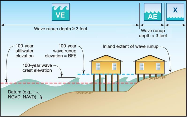
34 Step 3: Mapping Identification of VE AE AO X 34
35 Step 3: Runup VE Zones Intact transects VE zone mapped to elevation associated with TWL Failed transects (coastal structures) VE zone mapped to station along the profile associated with TWL Elevation will not match topography since failure include profile modification Eroded profiles VE zone mapped to station along the profile associated with TWL Elevation will not match topography since profile is eroded 35

36 Step 3: Other Overtopping Zones AO Zones Applied in areas of shallow flooding, usually sheet flow on sloping terrain BFEs not provided, instead average flood depths of between one and three feet is specified Flooding depth associated with overtopping rate 36
37 Step 3: Overland Wave Propagation VE Zones VE zone associated with the location of the 3 foot breaking wave AE zones can exist with BFEs higher than TSWL as wave action is considered Most conservative of the 5 WHAFIS runs selected for mapping Most conservative is associated with largest extend of flooding and highest VE zone 37

38 Step 3: SWL or TSWL Inundation 38


39 Step 3: Zone Breaks Zone Breaks Along the Coast Represent the Extents of Each Unique Coastal Feature 39


40 Draft Work Map vs FIS/FIRM Door County, WI Work Map Door County, WI effective FIRM Will not affect flood insurance requirements or costs 40
41 Interactive session to review the coastal work maps COASTAL WORK MAP DEMO 41
42 Door County, WI FEMA FLOODPLAIN MANAGEMENT 42
43 Current Study Status Lake-Wide Storm Surge and Waves Study County Based Overland Analyses You are here Workmap Production Comment Period FIRM Production Preliminary FIRM FPM Workshops Community Coordination Meeting Comment and Appeal Periods Letter of Final Determination Effective FIRM 6 months update ordinance 43
44 Floodplain Management Workshops Conducted by FEMA/DNR just before preliminary maps are released Workshop details: Approximately 3 4 hours Designed for floodplain administrator, zoning official, building inspectors, permit officials, etc. Basics of Coastal Flooding Using the Flood Insurance Study and FIRM for coastal studies Floodplain Management Standards in Coastal High Hazard Areas (in depth) NFIP Insurance in Coastal Zones 44
45 Key V Zone minimum standard: 44 CFR 60.3(e) The community must require that all new construction and substantial improvements have the lowest horizontal structural member of the lowest floor elevated to or above the base flood level, with the space below the lowest floor either free of obstruction or constructed with nonsupporting breakaway walls 45

46 Lowest horizontal structural member 46

47 Other key standards in Zone VE: Fill for structural support is prohibited Elevated portion of the building and piling/column foundation must be designed to withstand water and wind loads acting simultaneously under base flood conditions Structural design, specifications and plans for construction must be developed or reviewed and certified by a registered professional engineer or architect 47
48 Model Ordinance Development FEMA Region V and Wisconsin DNR are working together to prepare a model ordinance to incorporate V zone standards Wisconsin DNR is working through their legal chains to determine the requirements per NR 116 Ordinances must be updated/adopted by effective date of maps 48


49 Online Resources High resolution oblique aerial images Great Lakes Coastal Resilience Planning: 49

50 Great Lakes Coastal Flood Study 50
51 Door County, WI NEXT STEPS 51
52 Comments Send comments via to or mail to: Great Lakes Coastal Flood Study Comment Repository c/o CDM Smith Attn: Jordan Williams th Ave, Suite 500 Denver, CO Include county, community, map panel number, description of area (screenshots or drawings are very helpful), detailed comment, and contact information You will receive acknowledgement of receipt of your comment within 3 business days Within 3 weeks, FEMA s response will indicate if enough technical justification was provided to necessitate a map change If you are not satisfied with a comment response on technical grounds, consider using the appeal process during Preliminary FIRM rollout 52
53 Next Steps Review and comment period ends 9/26/2017. FEMA s next steps: Inventory all comments received Evaluate and incorporate comments and data as appropriate Move studies into the NFIP regulatory process (developing FIRMs) 53
54 FEMA Contacts Sarah Hayman Civil Engineer, Mitigation Division FEMA Region sarah.hayman@fema.dhs.gov Ken Hinterlong Senior Engineer, Risk Analysis FEMA Region ken.hinterlong@fema.dhs.gov COMMENT REPOSITORY: Send comments via to williamsjo@cdmsmith.com or mail to: Great Lakes Coastal Flood Study Comment Repository c/o CDM Smith Attn: Jordan Williams th Ave, Suite 500 Denver, CO

55 Questions? Thank you for your participation! 55

56 Coastal Risk Awareness KNOW YOUR RISK Do your residents know about their flood risk? KNOW YOUR ROLE Do your residents know what mitigation actions they should/can take? TAKE ACTION Encourage your residents to take the actions that can build their resiliency to flooding. 56
St. Louis County, MN Coastal Hazard Analysis Flood Risk Review Meeting. May 2, 2018
 St. Louis County, MN Coastal Hazard Analysis Flood Risk Review Meeting May 2, 2018 Agenda Introductions Coastal Flood Risk Study and Mapping Program Current Status Technical Overview of Study and Mapping
Bayfield & Ashland Counties, WI Coastal Hazard Analysis Flood Risk Review Meeting. June 05, 2018
 Bayfield & Ashland Counties, WI Coastal Hazard Analysis Flood Risk Review Meeting June 05, 2018 Agenda Introductions Coastal Flood Risk Study and Mapping Program Current Status Technical Overview of Study
Baraga County, MI Coastal Hazard Analysis Flood Risk Review Meeting. July 12, 2018
 Baraga County, MI Coastal Hazard Analysis Flood Risk Review Meeting July 12, 2018 Agenda Introductions Coastal Flood Risk Study and Mapping Program Current Status Technical Overview of Study and Mapping
Bay County, MI Coastal Hazard Analysis Flood Risk Review Meeting. May 14, 2018
 Bay County, MI Coastal Hazard Analysis Flood Risk Review Meeting May 14, 2018 Agenda Introductions Coastal Flood Risk Study and Mapping Program Current Status Technical Overview of Study and Mapping Floodplain
2016 NC Coastal Local Governments Annual Meeting
 2016 NC Coastal Local Governments Annual Meeting Coastal Flood Study Modeling and Mapping 101 April 21, 2016 Tom Langan, PE, CFM Engineering Supervisor NCEM Floodplain Mapping Program FEMA Coastal Flood
Citrus, Hernando, and Pasco Coastal Hazard Analysis. Flood Risk Review Meeting Citrus, Hernando, and Pasco Counties, Florida December 14, 2017
 Citrus, Hernando, and Pasco Coastal Hazard Analysis Flood Risk Review Meeting Citrus, Hernando, and Pasco Counties, Florida December 14, 2017 Introductions Risk MAP Project Team FEMA Region IV RAMPP (study
Photo by: Darryl Hatheway, 2011
 Photo by: Darryl Hatheway, 2011 September 11, 2015 Presentation Discussion Examine PFD V-Zone Mapping in Wave Runup Dominated West Coast Application of PFD V-Zone Mapping Criteria in Pacific G&S PFD V-Zone
FEMA Region V. Great Lakes Coastal Flood Study. Pilot Study Webinar. Berrien County, Michigan. February 26, 2014
 FEMA Region V Great Lakes Coastal Flood Study Pilot Study Webinar Berrien County, Michigan February 26, 2014 2 Pilot Study Webinar Agenda Great Lakes Coastal Flood Study Background Demonstration Project
Monterey County December 3, 2014
 Flood Risk Review Meeting: Open Pacific Coast Study Monterey County December 3, 2014 Welcome and Introductions Flood Risk Review Meeting Monterey County California Coastal Analysis and Mapping Project
The History of Coastal Flood Hazard Assessments in the Great Lakes
 The History of Coastal Flood Hazard Assessments in the Great Lakes Brian A. Caufield, P.E., CFM June 23, 2016 2 The Great Lakes Some Statistics Courtesy of Great Lakes Information Network One-fifth of
San Luis Obispo County December 2, 2014
 Flood Risk Review Meeting: Open Pacific Coast Study San Luis Obispo County December 2, 2014 Welcome and Introductions Flood Risk Review Meeting San Luis Obispo County California Coastal Analysis and Mapping
2017 Preliminary FEMA Flood Maps Old Orchard Beach Town Council Meeting. Old Orchard Beach, Town Hall July 18, 2017
 2017 Preliminary FEMA Flood Maps Old Orchard Beach Town Council Meeting Old Orchard Beach, Town Hall July 18, 2017 Overview Potential impacts of inaccurate Flood Insurance Rate Maps (FIRM) Why is appealing
Evaluation of June 9, 2014 Federal Emergency Management Agency Flood Insurance Study for Town of Weymouth, Norfolk, Co, MA
 Evaluation of June 9, 2014 Federal Emergency Management Agency Flood Insurance Study for Town of Weymouth, Norfolk, Co, MA Prepared For: Woodard & Curran 95 Cedar Street, Suite 100 Providence, RI 02903
Physical Map Revisions in Connecticut due to Updated Coastal Flood Hazards F8: Maps in Transition
 Physical Map Revisions in Connecticut due to Updated Coastal Flood Hazards F8: Maps in Transition Brian Caufield, P.E., CFM Principal Engineer CDM Smith Kerry Bogdan, CFM Senior Engineer FEMA Region I
Sussex County, DE Preliminary Study Overview
 Sussex County, DE Preliminary Study Overview Coastal study scope: 102 miles of entire County shoreline Revised 102 panels for coastal study Riverine study scope: 14 streams, 67.1 miles, within the Nanticoke
Ventura County. Open Pacific Coast Study. California Coastal Analysis and Mapping Project
 Ventura County Open Pacific Coast Study California Coastal Analysis and Mapping Project December 2011 Project Name: Meeting: Date and Time: Location: California Coastal Analysis and Mapping Project (CCAMP)/Open
Figure 1 GE image of the Costa Sur & EcoEléctrica power plants, located inside Guayanilla and Tallaboa bay.
 1 7 - STORM SURGES IN PUERTO RICO_Power Plants-Costa Sur & EcoElectrica Costa Sur & EcoEléctrica Figure 1 shows a GE image of the Costa Sur (Guayanilla) and EcoElectrica site. Figure 2 shows the topographic
We Make a Difference. New Maps, Now What? Updated Coastal Flood Hazard Information for Southern Georgia
 New Maps, Now What? Updated Coastal Flood Hazard Information for Southern Georgia New Maps, Now What? Risk MAP Project Team FEMA Region IV BakerAECOM, FEMA Mapping Partner GA DNR (CTP) NEFL Duval Flagler
City of Del Mar Local Coastal Plan (LCP) Amendment for Sea Level Rise and Coastal Flooding
 Amendment for Sea Level Rise and Coastal Flooding") City of Del Mar Local Coastal Plan (LCP) Amendment for Sea Level Rise and Coastal Flooding 6/22/17 Presentation to Sea Level Rise Stakeholder- Technical Advisory Committee (STAC) Nick Garrity, P.E. Lindsey
City of Del Mar Local Coastal Plan (LCP) Amendment for Sea Level Rise and Coastal Flooding 6/22/17 Presentation to Sea Level Rise Stakeholder- Technical Advisory Committee (STAC) Nick Garrity, P.E. Lindsey
FEMA West Coast Sea Level Rise Pilot Study
 FEMA West Coast Sea Level Rise Pilot Study Ed Curtis, P.E., CFM FEMA Region IX June 4, 2014 Presentation Objectives Present the goals of the FEMA West Coast Sea Level Rise Pilot Study Review the SLR Pilot
Open Pacific Coast Study. California Coastal Analysis and Mapping Project
 Open Pacific Coast Study California Coastal Analysis and Mapping Project September 2012 California Open Coast Counties California Coastal Analysis and Mapping Project This publication is an initiative
Bob Battalio, PE Chief Engineer, ESA September 8, 2016
 RELATING FUTURE COASTAL CONDITIONS TO EXISTING FEMA FLOOD HAZARD MAPS Technical Methods Manual Bob Battalio, PE Chief Engineer, ESA September 8, 2016 FMA 2016 Sacramento, California DWR-OST-SIO PILOTING
SUPPLEMENTAL DOCUMENT SEA LEVEL RISE SCENARIO SELECTION AND DESIGN TIDE CALCULATION
 SUPPLEMENTAL DOCUMENT SEA LEVEL RISE SCENARIO SELECTION AND DESIGN TIDE CALCULATION FOR THE GUIDANCE FOR INCORPORATING SEA LEVEL RISE INTO CAPITAL PLANNING IN SAN FRANCISCO: ASSESSING VULNERABILITY AND
Future Condi,ons coastal hazard modeling and mapping
 Future Condi,ons coastal hazard modeling and mapping Presented by Bob Ba:alio, PE Environmental Science Associates, Inc. (ESA) On behalf of the physical processes team (USGS, TerraCosta- Scripps, ESA)
A Coastal Storm Modeling System for determination of flood hazards along a high energy coast in response to SLR and 21 st century storms
 Li Erikson, Patrick Barnard, Andrea O Neill, Jodi Eshleman, Amy Foxgrover, Michael Fitzgibbon 2, Grant Ballard 2, Kelly Higgason 3 A Coastal Storm Modeling System for determination of flood hazards along
MODELING OF CLIMATE CHANGE IMPACTS ON COASTAL STRUCTURES - CONTRIBUTION TO THEIR RE-DESIGN
 Proceedings of the 14 th International Conference on Environmental Science and Technology Rhodes, Greece, 3-5 September 2015 MODELING OF CLIMATE CHANGE IMPACTS ON COASTAL STRUCTURES - CONTRIBUTION TO THEIR
Technical Brief - Wave Uprush Analysis 129 South Street, Gananoque
 Technical Brief - Wave Uprush Analysis 129 South Street, Gananoque RIGGS ENGINEERING LTD. 1240 Commissioners Road West Suite 205 London, Ontario N6K 1C7 June 12, 2013 Table of Contents Section Page Table
CALCASIEU SALINITY STRUCTURES. HYDRODYNAMIC MODELING (To Support Design of Salinity Barriers)
") CALCASIEU SALINITY STRUCTURES HYDRODYNAMIC MODELING (To Support Design of Salinity Barriers) Presentation Overview 1 2 3 4 5 Project Overview and CEA Circulation Modeling Vessel Hydrodynamics Modeling
CALCASIEU SALINITY STRUCTURES HYDRODYNAMIC MODELING (To Support Design of Salinity Barriers) Presentation Overview 1 2 3 4 5 Project Overview and CEA Circulation Modeling Vessel Hydrodynamics Modeling
Leaning Into Adaptation
 www.marinslr.org Leaning Into Adaptation GFNMS Ocean Summit, May 17, 2016 Jack Liebster, Planning Manager, Marin County Marin County C-SMART Sea Level Rise Adaptation Process Evaluate Science Info. Implement
LOCALLY CONCENTRATED SEVERE BEACH EROSION ON SEISHO COAST CAUSED BY TYPHOON T0709
 F-4 Fourth International Conference on Scour and Erosion 2008 LOCALLY CONCENTRATED SEVERE BEACH EROSION ON SEISHO COAST CAUSED BY TYPHOON T0709 Yoshimitsu TAJIMA 1 and Shinji SATO 2 1 Member of JSCE, Associate
SEA LEVEL RISE IMPACT ASSESSMENT AND MITIGATION ALTERNATIVES DEVELOPMENT FOR BALBOA ISLANDS, CITY OF NEWPORT BEACH, CALIFORNIA
 SEA LEVEL RISE IMPACT ASSESSMENT AND MITIGATION ALTERNATIVES DEVELOPMENT FOR BALBOA ISLANDS, CITY OF NEWPORT BEACH, CALIFORNIA Ying Poon 1, Brett Sanders 2, Randy Mason 3 and Robert Stein 4 The City of
Technical Brief - Wave Uprush Analysis Island Harbour Club, Gananoque, Ontario
 Technical Brief - Wave Uprush Analysis RIGGS ENGINEERING LTD. 1240 Commissioners Road West Suite 205 London, Ontario N6K 1C7 October 31, 2014 Table of Contents Section Page Table of Contents... i List
Boothbay Harbor Rotary Club May 12, 2016
 Mapping Potential Sea Level Rise and Storm Surge in Boothbay Harbor, ME Boothbay Harbor Rotary Club May 12, 2016 Peter A. Slovinsky, Marine Geologist Maine Geological Survey S.M. Dickson, MGS Quickly,
Pathways Interns: Annika O Dea, Ian Conery, Andrea Albright
 1 REMOTE SENSING OF COASTAL MORPHODYNAMICS 237 237 237 217 217 217 2 2 2 8 119 27 252 174.59 255 255 255 163 163 163 131 132 122 239 65 53 11 135 12 112 92 56 62 12 13 12 56 48 13 12 111 Kate Brodie Brittany
Volume and Shoreline Changes along Pinellas County Beaches during Tropical Storm Debby
 Volume and Shoreline Changes along Pinellas County Beaches during Tropical Storm Debby Ping Wang and Tiffany M. Roberts Coastal Research Laboratory University of South Florida July 24, 2012 Introduction
OECS Regional Engineering Workshop September 29 October 3, 2014
 B E A C H E S. M A R I N A S. D E S I G N. C O N S T R U C T I O N. OECS Regional Engineering Workshop September 29 October 3, 2014 Coastal Erosion and Sea Defense: Introduction to Coastal/Marine Structures
DUXBURY WAVE MODELING STUDY
 DUXBURY WAVE MODELING STUDY 2008 Status Report Duncan M. FitzGerald Peter S. Rosen Boston University Northeaster University Boston, MA 02215 Boston, MA 02115 Submitted to: DUXBURY BEACH RESERVATION November
HURRICANE SANDY LIMITED REEVALUATION REPORT UNION BEACH, NEW JERSEY DRAFT ENGINEERING APPENDIX SUB APPENDIX D SBEACH MODELING
 HURRICANE SANDY LIMITED REEVALUATION REPORT UNION BEACH, NEW JERSEY DRAFT ENGINEERING APPENDIX SUB APPENDIX D SBEACH MODELING Rev. 18 Feb 2015 1 SBEACH Modeling 1.0 Introduction Following the methodology
Inlet Management Study for Pass-A-Grille and Bunces Pass, Pinellas County, Florida
 Inlet Management Study for Pass-A-Grille and Bunces Pass, Pinellas County, Florida Final Report Submitted By Ping Wang, Ph.D., Jun Cheng Ph.D., Zachary Westfall, and Mathieu Vallee Coastal Research Laboratory
Wave Energy Research and Applications
 Wave Energy Research and Applications Shoreline and Shallows conference East Lansing, MI March 7, 2019 Photo: Dave Sanford Waves Background 1. Types of Waves 2. Good and Bad Waves 3. Restoration Impacts
VOLUME 2 OF 5 VOLUSIA COUNTY, FLORIDA AND INCORPORATED AREAS COMMUNITY NAME NUMBER COMMUNITY NAME NUMBER
 VOLUME 2 OF 5 VOLUSIA COUNTY, FLORIDA AND INCORPORATED AREAS COMMUNITY NAME NUMBER COMMUNITY NAME NUMBER DAYTONA BEACH, CITY OF 125099 NEW SMYRNA BEACH, CITY OF 125132 DAYTONA BEACH SHORES, CITY OF 125100
Modeling Sediment Transport Along the Upper Texas Coast
 Modeling Sediment Transport Along the Upper Texas Coast David B. King Jr. Jeffery P. Waters William R. Curtis Highway 87 roadbed, Jefferson County Galveston District Corps Sabine Pass to San Luis Pass
STUDY ON TSUNAMI PROPAGATION INTO RIVERS
 ABSTRACT STUDY ON TSUNAMI PROPAGATION INTO RIVERS Min Roh 1, Xuan Tinh Nguyen 2, Hitoshi Tanaka 3 When tsunami wave propagation from the narrow river mouth, water surface is raised and fluctuated by long
SANTA ROSA COUNTY, FLORIDA AND INCORPORATED AREAS
 VOLUME 1 OF 1 SANTA ROSA COUNTY, FLORIDA AND INCORPORATED AREAS COMMUNITY NAME GULF BREEZE, CITY OF 120275 JAY, TOWN OF 120339 MILTON, CITY OF 120276 SANTA ROSA COUNTY, UNINCORPORATED AREAS COMMUNITY NUMBER
BILLY BISHOP TORONTO CITY AIRPORT PRELIMINARY RUNWAY DESIGN COASTAL ENGINEERING STUDY
 Bâtiment Infrastructures municipales Transport Industriel Énergie Environnement BILLY BISHOP TORONTO CITY AIRPORT PRELIMINARY RUNWAY DESIGN COASTAL ENGINEERING STUDY N. Guillemette 1, C. Glodowski 1, P.
Appendix M: Durras Lake Tailwater Conditions
 Appendix M: Durras Lake Tailwater Conditions M.1 Preamble WRL has completed a tailwater condition assessment for the entrance to Durras Lake, to be used as an ocean boundary condition for a future flood
Update: UNSW s Research Program for Extreme Waves on Fringing Reefs. Matt Blacka,Kristen Splinter, Ron Cox
 Update: UNSW s Research Program for Extreme Waves on Fringing Reefs Matt Blacka,Kristen Splinter, Ron Cox Overview Research Area 1: Extreme wave and water level processes for fringing reef coastlines Research
REVETMENTS. Purposes and Operational Constraints. Purposes Erosion control o o. Revetment Design 4/5/2016. CE A676 Coastal Engineering
 REVETMENTS Ijsseldam, the Netherlands Orson P. Smith, PE, Ph.D. Instructor Purposes and Operational Constraints Purposes Erosion control o o Embankment Toe protection for a seawall, retaining wall or other
Fortified For Safer Living
 Fortified For Safer Living Module 15: Protecting Homes Against Floods and Storm Surge An important part of trying to reduce the damage and losses from storm events is to make sure that the home doesn t
ST. LUCIE COUNTY, FLORIDA
 ST. LUCIE COUNTY, FLORIDA COASTAL STORM RISK MANAGEMENT STUDY Draft Feasibility Study & Integrated Environmental Assessment Public Meeting Presented by U.S. Army Corps of Engineers Jacksonville District
SELECTION OF THE PREFERRED MANAGEMENT OPTION FOR STOCKTON BEACH APPLICATION OF 2D COASTAL PROCESSES MODELLING
 SELECTION OF THE PREFERRED MANAGEMENT OPTION FOR STOCKTON BEACH APPLICATION OF 2D COASTAL PROCESSES MODELLING C Allery 1 1 DHI Water and Environment, Sydney, NSW Abstract This paper presents an approach
COASTAL HAZARDS. What are Coastal Hazards?
 COASTAL HAZARDS What are Coastal Hazards? Hazards in the New Jersey coastal zone include unavoidable risks to life and property generated by: coastal flooding, waves, high winds and waves, short-term and
To: William Woods, Jenni Austin Job No: CentrePort Harbour Deepening Project - Comments on community queries
 Memo To: William Woods, Jenni Austin From: Richard Reinen-Hamill Date: Subject: cc: 1 Purpose This memo sets out our response to issues raised at and after Seatoun community consultation sessions held
MIKE Release General product news for Marine software products, tools & features. Nov 2018
 MIKE Release 2019 General product news for Marine software products, tools & features Nov 2018 DHI 2012 MIKE 3 Wave FM New advanced phase-resolving 3D wave modelling product A MIKE 3 FM Wave model - why?
IMAGE-BASED FIELD OBSERVATION OF INFRAGRAVITY WAVES ALONG THE SWASH ZONE. Yoshimitsu Tajima 1
 IMAGE-BASED FIELD OBSERVATION OF INFRAGRAVITY WAVES ALONG THE SWASH ZONE Yoshimitsu Tajima 1 This study develops an image-based monitoring techniques for observations of surf zone hydrodynamics especially
UPPER BEACH REPLENISHMENT PROJECT RELATED
 ASSESSMENT OF SAND VOLUME LOSS at the TOWNSHIP of UPPER BEACH REPLENISHMENT PROJECT RELATED to the LANDFALL OF HURRICANE SANDY - PURSUANT TO NJ-DR 4086 This assessment is in response to Hurricane Sandy
DELAWARE S VULNERABLE COASTAL AREAS. DELAWARE INLAND BAYS and DELAWARE BAY RECONNAISSANCE STUDY
 DELAWARE S VULNERABLE COASTAL AREAS and the DELAWARE INLAND BAYS and DELAWARE BAY RECONNAISSANCE STUDY Kimberly K. McKenna, PG Delaware Dept. of Natural Resources & Environmental Control Division of Watershed
A PRACTICAL APPROACH TO MAPPING EXTREME WAVE INUNDATION: CONSEQUENCES OF SEA-LEVEL RISE AND COASTAL EROSION.
 A PRACTICAL APPROACH TO MAPPING EXTREME WAVE INUNDATION: CONSEQUENCES OF SEA-LEVEL RISE AND COASTAL EROSION. Sean Vitousek 1, Charles H. Fletcher 1, Matthew M. Barbee 1 1. Department of Geology and Geophysics,
LOCAL COASTAL PROGRAM UPDATE
 LOCAL COASTAL PROGRAM UPDATE Agenda Meeting #1 General Information (1 1:45 pm) Introductions and Background Grants involved What is a Local Coastal Program? What is required? LCP Update tasks and schedule
Baird. Innovation, Excellence & Service Oceans, Lakes & Rivers
 Profile Capabilities Innovation, Excellence & Service Oceans, Lakes & Rivers Baird provides professional engineering and technical services related to the design of coastal structures and facilities that
COASTAL MORPHODYNAMICS
 COASTAL MORPHODYNAMICS PATRICIA CHARDÓN-MALDONADO, PHD, EIT Miguel Canals, Jack A. Puleo, Alec Torres-Freyermuth & Jens Figlus March 9, 2017 OUTLINE INTRODUCTION Meteorological Phenomena Forcing Conditions
INTRODUCTION TO COASTAL ENGINEERING
 The University of the West Indies Organization of American States PROFESSIONAL DEVELOPMENT PROGRAMME: COASTAL INFRASTRUCTURE DESIGN, CONSTRUCTION AND MAINTENANCE A COURSE IN COASTAL DEFENSE SYSTEMS I CHAPTER
SHORE PROTECTION AND HABITAT CREATION AT SHAMROCK ISLAND, TEXAS ABSTRACT
 SHORE PROTECTION AND HABITAT CREATION AT SHAMROCK ISLAND, TEXAS M. Cameron Perry, P.E., and Daniel J. Heilman, P.E. Coastal Engineer Shiner Moseley & Associates., Inc. 555 N. Carancahua Corpus Christi,
Hydrodynamic Modeling of Tides and Hurricane Storm Surge for Pre- and Post-Dredging Conditions in the Lower St. Johns River, Florida
 Hydrodynamic Modeling of Tides and Hurricane Storm Surge for Pre- and Post-Dredging Conditions in the Lower St. Johns River, Florida Matthew V. Bilskie 1 1 PhD Student, University of Central Florida, Department
What are we adapting to? David Provis Senior Principal, Oceanography, Cardno Member, Victorian Coastal Council
 What are we adapting to? David Provis Senior Principal, Oceanography, Cardno Member, Victorian Coastal Council Sea-level -NOAA Sea-level - NOAA 90% probability ranges Sea-level - NOAA Sea-level Port Phillip
October 4, Seabreeze Associates Limited Partnership Robert B. Fultz, General Partner 865 Highland Drive Boulder Creek, California 95006
 1 October 4, 2016 Seabreeze Associates Limited Partnership Robert B. Fultz, General Partner 865 Highland Drive Boulder Creek, California 95006 Subject: Preliminary Site Investigation and Dune Hazard Report
Soft Designs for a Harsh Climate: Trends in Coastal Engineering
 Alaska Department of Transportation & Public Facilities Ruth Carter, PE, and Harvey Smith, PE Coastal Engineering Section 20 October 2014 Soft Designs for a Harsh Climate: Trends in Coastal Engineering
TITLE: The Importance of Model Validation: Two Case Studies. AUTHOR:Julie Thomas. Scripps Institution of Oceanography, La Jolla, CA.
 TITLE: The Importance of Model Validation: Two Case Studies AUTHOR:Julie Thomas Scripps Institution of Oceanography, La Jolla, CA jothomas@ucsd.edu CO-AUTHOR: Corey Olfe Scripps Institution of Oceanography,
Technical Report Culvert A Hydraulic Analysis
 DATE: November 3, 2011 Technical Report Culvert A Hydraulic Analysis TO: FROM: RE: Jim Reiser, P.E. Project Manager Parsons Brinckerhoff, Inc. Kurt Killian, P.E., CFM Parsons Brinckerhoff, Inc. Design
ALTERNATIVES FOR COASTAL STORM DAMAGE MITIGATION AND FUNCTIONAL DESIGN OF COASTAL STRUCTURES
 The University of the West Indies Organization of American States PROFESSIONAL DEVELOPMENT PROGRAMME: COASTAL INFRASTRUCTURE DESIGN, CONSTRUCTION AND MAINTENANCE A COURSE IN COASTAL DEFENSE SYSTEMS I CHAPTER
MECHANISM AND COUNTERMEASURES OF WAVE OVERTOPPING FOR LONG-PERIOD SWELL IN COMPLEX BATHYMETRY. Hiroaki Kashima 1 and Katsuya Hirayama 1
 MECHANISM AND COUNTERMEASURES OF WAVE OVERTOPPING FOR LONG-PERIOD SWELL IN COMPLEX BATHYMETRY Hiroaki Kashima 1 and Katsuya Hirayama 1 Recently, coastal disasters due to long-period swells induced by heavy
Assessing Tidal Flood Risk in Ireland: Modelling, Mapping & Forecasting Coastal and Tidal Flood Risk for Irish APSFRs
 Assessing Tidal Flood Risk in Ireland: Modelling, Mapping & Forecasting Coastal and Tidal Flood Risk for Irish APSFRs Dr. John Martin C.Eng. OPW Flood Risk Assessment & Management Section, Ireland WG-F
Mouth of the Columbia River Jetties Three-Phase Construction Plan
 Mouth of the Columbia River Jetties Three-Phase Construction Plan Project Overview October 9, 2012 US Army Corps of Engineers MCR Jetties Major Rehabilitation Sand Island pile dikes 1930-1935 Columbia
Technical Methods Manual Prepared for October 2016 California Department of Water Resources and California Ocean Science Trust
 RELATING FUTURE COASTAL CONDITIONS TO EXISTING FEMA FLOOD HAZARD MAPS Technical Methods Manual Prepared for October 2016 California Department of Water Resources and California Ocean Science Trust RELATING
WASHINGTON COUNTY, MAINE (ALL JURISDICTIONS)
") VOLUME 1 OF 1 WASHINGTON COUNTY, MAINE (ALL JURISDICTIONS) COMMUNITY NAME CID COMMUNITY NAME CID TOWN OF ADDISON 230132 TOWNSHIP OF BROOKTON 230470 TOWN OF ALEXANDER 230303 CITY OF CALAIS 230134 TOWN OF
VOLUME 1 OF 1 WASHINGTON COUNTY, MAINE (ALL JURISDICTIONS) COMMUNITY NAME CID COMMUNITY NAME CID TOWN OF ADDISON 230132 TOWNSHIP OF BROOKTON 230470 TOWN OF ALEXANDER 230303 CITY OF CALAIS 230134 TOWN OF
SPO Regional Challenge Grant Creation of a Sea Level Adaption Working Group for Biddeford, Saco, OOB and Scarborough J.T. Lockman, AICP, Planning
 SPO Regional Challenge Grant Creation of a Sea Level Adaption Working Group for Biddeford, Saco, OOB and Scarborough J.T. Lockman, AICP, Planning Director Southern Maine Regional Planning Commission jlockman@smrpc.org
ALTERNATIVES FOR COASTAL STORM DAMAGE MITIGATION
 ALTERNATIVES FOR COASTAL STORM DAMAGE MITIGATION Dave Basco Old Dominion University, Norfolk, Virginia, USA National Park Service Photo STRUCTURAL (changes to natural, physical system) hardening (seawalls,
Assateague Island National Seashore North End Restoration Project Timeline
 Assateague Island National Seashore North End Restoration Project Timeline Date Event Some information provided in the Project Introduction document. Detailed events are available in a timeline compiled
Coastal Hazards Study
 Coastal Hazards Study 2212 Beach Boulevard, Pacifica Prepared for: EXECUTIVE SUMMARY City of Pacifica 170 Santa Maria Ave Pacifica, CA 94044 Prepared by: moffatt & nichol 2185 N. California Blvd. Walnut
IMPACTS OF COASTAL PROTECTION STRATEGIES ON THE COASTS OF CRETE: NUMERICAL EXPERIMENTS
 IMPACTS OF COASTAL PROTECTION STRATEGIES ON THE COASTS OF CRETE: NUMERICAL EXPERIMENTS Tsanis, I.K., Saied, U.M., Valavanis V. Department of Environmental Engineering, Technical University of Crete, Chania,
MONITORING SEDIMENT TRANSPORT PROCESSES AT MANAVGAT RIVER MOUTH, ANTALYA TURKEY
 COPEDEC VI, 2003 in Colombo, Sri Lanka MONITORING SEDIMENT TRANSPORT PROCESSES AT MANAVGAT RIVER MOUTH, ANTALYA TURKEY Isikhan GULER 1, Aysen ERGIN 2, Ahmet Cevdet YALCINER 3 ABSTRACT Manavgat River, where
HARBOUR SEDIMENTATION - COMPARISON WITH MODEL
 HARBOUR SEDIMENTATION - COMPARISON WITH MODEL ABSTRACT A mobile-bed model study of Pointe Sapin Harbour, in the Gulf of St. Lawrence, resulted in construction of a detached breakwater and sand trap to
consulting engineers and scientists
 consulting engineers and scientists Coastal Processes Presented by: January 9, 2015 Varoujan Hagopian, P.E. F.ASCE Senior Consultant, Waterfront Engineer Living Shoreline Workshop Lets Remember Why We
Louisiana s 2012 Coastal Master Plan BARRIER SHORELINE MORPHOLOGY MODEL
 Louisiana Coastal Protection & Restorat coastal.louisiana.gov Louisiana s 2012 Coastal Master Plan PREDICTIVE MODELING: committed to our coast BARRIER SHORELINE MORPHOLOGY MODEL Dallon Weathers, University
LAB: WHERE S THE BEACH
 Name: LAB: WHERE S THE BEACH Introduction When you build a sandcastle on the beach, you don't expect it to last forever. You spread out your towel to sunbathe, but you know you can't stay in the same spot
New Jersey Coastal Zone Overview. The New Jersey Beach Profile Network (NJBPN) 3 Dimensional Assessments. Quantifying Shoreline Migration
 3 Dimensional Assessments. Quantifying Shoreline Migration") New Jersey Coastal Zone Overview The New Jersey Beach Profile Network (NJBPN) Objectives Profile Locations Data Collection Analyzing NJBPN Data Examples 3 Dimensional Assessments Methodology Examples Quantifying
New Jersey Coastal Zone Overview The New Jersey Beach Profile Network (NJBPN) Objectives Profile Locations Data Collection Analyzing NJBPN Data Examples 3 Dimensional Assessments Methodology Examples Quantifying
Deep-water orbital waves
 What happens when waves approach shore? Deep-water orbital waves Fig. 9.16, p. 211 Wave motion is influenced by water depth and shape of the shoreline wave buildup zone surf zone beach Wave base deepwater
Taranaki Tsunami Inundation Analysis. Prepared for Taranaki Civil Defence Emergency Management Group. Final Version
 Taranaki Tsunami Inundation Analysis Prepared for Taranaki Civil Defence Emergency Management Group Final Version June 2012 AM 12/07 HBRC Plan Number 4362 Asset Management Group Technical Report Prepared
OFFICE OF THE CITY ADMINISTRATOR
 OFFICE OF THE CITY ADMINISTRATOR Gavin Newsom, Mayor Edwin M. Lee, City Administrator December 21, 2007 Mr. Eric Simmons, CFM National Flood Insurance Program Region IX, Mitigation Division U.S. Department
Preliminary Wake Wash Impact Analysis Redwood City Ferry Terminal, Redwood City, CA
 Technical Memorandum Preliminary Wake Wash Impact Analysis Redwood City Ferry Terminal, Redwood City, CA 1. Introduction The following preliminary wake wash impact analysis was initiated by the Port of
Project Incorporation of Sea Level Rise City of Newport Beach Approach for Balboa Islands, City of Newport Beach, California
 Project Incorporation of Sea Level Rise City of Newport Beach Approach for Balboa Islands, City of Newport Beach, California Ying Poon, Everest International Consultants, Inc. CMANC Annual Winter Meeting
Town of Duck, North Carolina
 Tracking No. 00.00.2010 Erosion Mitigation And Shoreline Management Feasibility Study Town of Duck, North Carolina Coastal Planning & Engineering of North Carolina August 15, 2012 Tom Jarrett Robert Neal
CHAPTER 281 INFLUENCE OF NEARSHORE HARDBOTTOM ON REGIONAL SEDIMENT TRANSPORT
 CHAPTER 281 INFLUENCE OF NEARSHORE HARDBOTTOM ON REGIONAL SEDIMENT TRANSPORT Paul C.-P. Lin, Ph.D., P.E. 1 and R. Harvey Sasso, P.E. 2 ABSTRACT The influence of nearshore hardbottom on longshore and cross-shore
A Preliminary Review of Beach Profile and Hardbottom Interactions
 A Preliminary Review of Beach Profile and Hardbottom Interactions Douglas W. Mann, P.E., D.CE. CB&I A World of Solutions Presentation Goal Lead to a better understanding of the challenges regarding the
SACO RIVER AND CAMP ELLIS BEACH SACO, MAINE SECTION 111 SHORE DAMAGE MITIGATION PROJECT APPENDIX F ECONOMIC ASSESSMENT
 SACO RIVER AND CAMP ELLIS BEACH SACO, MAINE SECTION 111 SHORE DAMAGE MITIGATION PROJECT APPENDIX F ECONOMIC ASSESSMENT Department of the Army New England District, Corps of Engineers 696 Virginia Road
RE: Hurricane Matthew Beach Damage Assessment and Recommendations [CSE 2416]
![RE: Hurricane Matthew Beach Damage Assessment and Recommendations [CSE 2416]](/thumbs/83/87675702.jpg "RE: Hurricane Matthew Beach Damage Assessment and Recommendations [CSE 2416]") October 25, 2016 Iris Hill Town Administrator Town of Edisto Beach 2414 Murray St Edisto Beach SC 29438 RE: Hurricane Matthew Beach Damage Assessment and Recommendations [CSE 2416] Dear Iris, Hurricane
October 25, 2016 Iris Hill Town Administrator Town of Edisto Beach 2414 Murray St Edisto Beach SC 29438 RE: Hurricane Matthew Beach Damage Assessment and Recommendations [CSE 2416] Dear Iris, Hurricane
Beach Wizard: Development of an Operational Nowcast, Short-Term Forecast System for Nearshore Hydrodynamics and Bathymetric Evolution
 Beach Wizard: Development of an Operational Nowcast, Short-Term Forecast System for Nearshore Hydrodynamics and Bathymetric Evolution Ad Reniers Civil Engineering and Geosciences, Delft University of Technology
Ivan-like hurricane storm surge simulations for Tampa Bay, FL with 3-D and 2-D models
 Ivan-like hurricane storm surge simulations for Tampa Bay, FL with 3-D and 2-D models R.H. Weisberg and L. Zheng Storm Surge Workshop St. Pete Beach 2/11/09 Potential for Tampa Bay area inundation is large
FORMATION OF BREAKING BORES IN FUKUSHIMA PREFECTURE DUE TO THE 2011 TOHOKU TSUNAMI. Shinji Sato 1 and Shohei Ohkuma 2
 FORMATION OF BREAKING BORES IN FUKUSHIMA PREFECTURE DUE TO THE 2011 TOHOKU TSUNAMI Shinji Sato 1 and Shohei Ohkuma 2 Tsunami forces on critical coastal structures were reanalyzed by combining laboratory
Appendix D: SWAN Wave Modelling
 Appendix D: SWAN Wave Modelling D.1 Preamble The Eurobodalla Shire Council area is subject to extreme waves originating from offshore storms. When swell waves approach the coast, they are modified by the