Ocean Waves and Surf Forecasting: Wave Climate and Forecasting
|
|
|
- Silvia Mason
- 6 years ago
- Views:
Transcription
1 Overview Ocean Waves and Surf Forecasting: Wave Climate and Forecasting Ocean regions Characterizing and describing ocean waves Wave theory, propagation, and dispersion Refraction, shadowing, and bathymetry Stuart H. Sweeney Department of Geography University of California, Santa Barbara Wave climate Forecasting Winter 27 Time-Scales & Spatial-Scales Motivation Surfer questions: When will waves arrive from a storm at a given location? How big will the waves be when they arrive? Where should I surf? Will the waves break at one of the local beaches/reefs? Alternative approaches to answering the questions: Long time scale (long-distance trip planning): wave climate Near term (surf next week? tomorrow?): forecasting -Experience / local knowledge - On-line materials (Wavewatch III, surface analysis, CDIP) - Forecasting hobbiest Wave Climate: global Wave Climate: Regional (pp , Surf Science) Wave climate: Western Europe: Variation in wave characteristics (period, height, direction) over seasons for a particular place. - mid-lat depressions - December-March - Ex-hurricanes reform Aug / Sep - Ireland / UK biggest (and messiest) - France, Portugal, Spain clean big swells
2 Wave Climate: Regional (pp , Surf Science) Western Indian Ocean: - Cyclones north of equator; May/June, Oct/Nov big surf to Arabian Sea and Bay of Bengal. - Cyclones south of equator; Nov/Feb Madagascar, Mauritius, Reunion. Wave Climate: Regional (pp , Surf Science) Also look at: North Pacific Western North America Mexico & Central America Wave Climate: measurement Remote: Radar altimetry - radiation pulse, time delay surface height - long / short period wave mixed together - no directionality - good height measures and global coverage - wave source not distinguished In-situ: Buoys: detailed directional spectrum / limited coverage. Wave Climate: local Wave Climate: local Wave Climate: local
3 Wave Climate: local Forecasting: Short Range Surface pressure charts: - wind speed and direction (wind barbs) - path of the storm (lower / upper interaction) - local winds and expected changes Wave Height & Period Contours: - NOAA Wavewatch III - mathematical model: inputs(obs, other model output), output (directional spectrum and derived summaries) Wave buoy data - CDIP nowcast / forecasts Forecasting: Short Range Wave model issues: Not primarily intended for surfers Attempting to show areas of rough seas (shipping) Errors in input data (wind model) will result in errors in wave data Systematic under / over prediction -low quality wind sea overestimate height - high quality ground swell in narrow period band underestimate height. Directionality is average of spectrum at that location. Motivation Surfer questions: When will waves arrive from a storm at a given location? How big will the waves be when they arrive? Where should I surf? Will the waves break at one of the local beaches/reefs? Alternative approaches to answering the questions: Long time scale (long-distance trip planning): wave climate Near term (surf next week? tomorrow?): forecasting -Experience / local knowledge - On-line materials (Wavewatch III, surface analysis, CDIP) - Forecasting hobbiest How big? Wind Wave Pierson-Moskowitz spectrum (height, period)=f(fetch, wind speed, duration) Beaufort Scale Simplified Tables in Cool (pp , Tables B-2 and B-4) Example: (see Tables) How big? Energy Loss: Distance decay factor (Cool, pp. 6, Fig. 28) Angular spreading (Cool, pp. 61) Example: Assume: Winds: kts Location: beach 45 o off storm heading, ~7 km (Swell Height)x(Decay factor)x(1-spreading Loss) 13 x.4 x (1-25) = 4.5

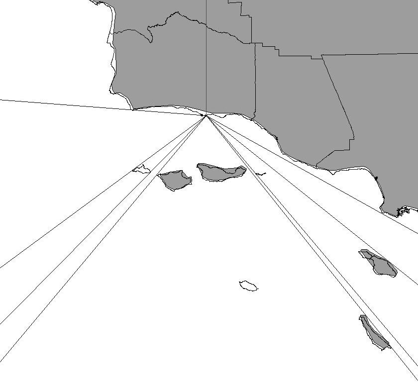
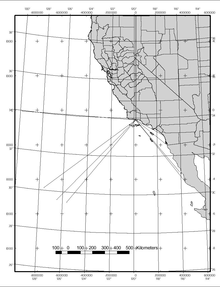
4 How big? Other factors: Some areas have greater than normal decay, which needs to be taken into account. Storms forming in the Tasman Sea located between Australia and New Zealand can be ideal for the local breaks on the east coast of Australia. However, swell-making systems moving north through this region will encounter an acute decay factor for other regions like California and Hawaii. Storms forming in the Tasman Sea face shallower ocean depths farther north and to the east due to the numerous South Pacific islands. These islands, including New Caledonia, Anuatu, Fiji, and Somoa have water depths around them ranging from only 2 to 2 meters, compared with deeper water depths of 4 meters of more in the lower portion of the Tasman Sea. These islands will soak up much of the energy before it can travel to California or Hawaii, causing greater than normal decay. Cool (23) pp Rate x Time = Distance Time = Distance / Rate Rate = Group Speed (c g ) Deep water wave speed: Wave speed ~ 1.56T m s -1 Group speed = c/2 ~ 8T m s -1 or 2.87T km per hour Example: (see Table) Rate x Time = Distance Time = Distance / Rate Distance = f(storm coordinates, reef/beach coordinates) Option 1: Azimuthal Equidistant Projection Option 2: Spherical Trigonometry Example: Storm: (-128,32) Campus Point: ( , ) Option 1: Measure distance on map d(storm,cp) = 97mm Use map scale to convert 12mm per 1km (from map scale) (1/12) x 97 = 88 km Arrival Time: (88 km / 28.1 kph) = 28.8 hours Example: Storm: (-128,32) Campus Point: ( , ) Option 2: see handout (from course website) Arrival Time: ( km / 28.1 kph) = hours Where should I surf? Swell Windows Use protractor and azimuthal equidistant map Read off or calculate swell windows Isochrones for given swell period Refraction Need bathymetric data Different wave rays and wave focusing for different swell directions. Not easy to calculate by hand
5 Table: Wind Wave Table: Wind Wave Wind Duration Height Period (T) (knots) (hours) (feet) (sec.) Wind Duration Height Period (T) (knots) (hours) (feet) (sec.) Table: Angular Spreading Loss Figure: Distance Decay Factor Angle Loss (degrees) Storm heading angle Your beach Figure: Distance Decay Factor Figure: Distance Decay Factor
 Speed (c) Speed kph mph.... 1-3.25.25 1 1.6 2.8 1.7 4-6.5.5 2 3.1 1.6 5.6 3.5 7-1 2 1 3 4.7 2.3 8.4 5.2 11-16 5 3 4 6.2 3.1 11.2 7. 17-21 1 5 6 9.4 4.7 16.8 1.4 22-27 15 13 1 15.6 7.8 28.1 17.")

6 Figure: Distance Decay Factor Table: Wind Wave Group Speed Wind Duration Height Period (T) Wave Swell Swell Speed (knots) (hours) (feet) (sec.) Speed (c) Speed kph mph If the storm is 7 km away and waves are 1 feet at the storm center, they will decay to 4 feet by the time they cover the distance to shore. Table: Wind Wave Group Speed Wind Duration Height Period (T) Wave Swell Swell Speed (knots) (hours) (feet) (sec.) Speed (c) Speed kph mph
7 36-(177-9)=273
Swell and Wave Forecasting
 Lecture 25 Swell and Wave Forecasting Swell and Wave Forecasting Motivation Terminology Wave Formation Wave Decay Wave Refraction Shoaling Rouge Waves 1 2 Motivation In Hawaii, surf is the number one weather-related
Swell and Wave Forecasting
 Lecture 24 Part II Swell and Wave Forecasting 29 Swell and Wave Forecasting Motivation Terminology Wave Formation Wave Decay Wave Refraction Shoaling Rouge Waves 30 Motivation In Hawaii, surf is the number
G. Meadows, H. Purcell and L. Meadows University of Michigan
 www.coj.net/departments/fire+and+rescue/emergency+preparedness/rip+current.htm G. Meadows, H. Purcell and L. Meadows Over 80% of all surf related rescues are attributable to Rip Currents According to the
Geography of Surfing: Final Exam Review
 Geography questions: Geography of Surfing: Final Exam Review Where is it? Why is it there? What is it? Are proximate things influencing it? How long will it be there? Stuart H. Sweeney Is it impacting
SEASONDE DETECTION OF TSUNAMI WAVES
 SEASONDE DETECTION OF TSUNAMI WAVES Belinda Lipa, John Bourg, Jimmy Isaacson, Don Barrick, and Laura Pederson 1 I. INTRODUCTION We here report on preliminary results of a study to assess the capability
MAR 110 LECTURE #14 Ocean Waves
 MAR 110: Lecture 14 Outline Ocean Waves 1 MAR 110 LECTURE #14 Ocean Waves Figure 19.1 Do Ocean Surface Waves Present a Hazard?...a picture is worth a thousand words Tsunamis - giant shallow water waves
An IOOS Operational Wave Observation Plan Supported by NOAA IOOS Program & USACE
 An IOOS Operational Wave Observation Plan Supported by NOAA IOOS Program & USACE R.E. Jensen, W.A. Birkemeier and W. Burnett JCOMM-Workshop on Wave Measurements from Buoys Wave Information to Application
Wave research at Department of Oceanography, University of Hawai i
 Wave research at Department of Oceanography, University of Hawai i Hawaii wave climate. Directional waverider buoys around Hawaii. Past and present wave-related research projects. Effect of tides on wave
WIND SPEED LENGTH OF TIME WIND BLOWS (Duration) DISTANCE OVER WHICH IT BLOWS (Fetch)
 DISTANCE OVER WHICH IT BLOWS (Fetch)") WAVES Up and down movement of ocean surface Transportation of energy across the water over vast distances If not stopped by anything, waves can travel entire oceans Size and speed depend upon: WIND SPEED
WAVES Up and down movement of ocean surface Transportation of energy across the water over vast distances If not stopped by anything, waves can travel entire oceans Size and speed depend upon: WIND SPEED
Waves. G. Cowles. General Physical Oceanography MAR 555. School for Marine Sciences and Technology Umass-Dartmouth
 Waves G. Cowles General Physical Oceanography MAR 555 School for Marine Sciences and Technology Umass-Dartmouth Waves Sound Waves Light Waves Surface Waves Radio Waves Tidal Waves Instrument Strings How
Name Class Date. Use the terms from the following list to complete the sentences below. Each term may be used only once. Some terms may not be used.
 Assessment Chapter Test B The Movement of Ocean Water USING KEY TERMS Use the terms from the following list to complete the sentences below. Each term may be used only once. Some terms may not be used.
Beach Wizard: Development of an Operational Nowcast, Short-Term Forecast System for Nearshore Hydrodynamics and Bathymetric Evolution
 Beach Wizard: Development of an Operational Nowcast, Short-Term Forecast System for Nearshore Hydrodynamics and Bathymetric Evolution Ad Reniers Civil Engineering and Geosciences, Delft University of Technology
Wave Propagation and Shoaling
 Wave Propagation and Shoaling Focus on movement and natural alteration of the characteristics of waves as they travel from the source region toward shore Waves moving from deep to intermediate/shallow
CHAPTER 6 DISCUSSION ON WAVE PREDICTION METHODS
 CHAPTER 6 DISCUSSION ON WAVE PREDICTION METHODS A critical evaluation of the three wave prediction methods examined in this thesis is presented in this Chapter. The significant wave parameters, Hand T,
The Setting - Climatology of the Hawaiian Archipelago. Link to Video of Maui Waves
 The Setting - Climatology of the Hawaiian Archipelago Link to Video of Maui Waves What caused this week s weather? What caused this weekend s weather? Today s Objective: Provide overview and description
Surface Waves NOAA Tech Refresh 20 Jan 2012 Kipp Shearman, OSU
 Surface Waves NOAA Tech Refresh 20 Jan 2012 Kipp Shearman, OSU Outline Surface winds Wind stress Beaufort scale Buoy measurements Surface Gravity Waves Wave characteristics Deep/Shallow water waves Generation
Chapter 10 Waves. wave energy NOT the water particles moves across the surface of the sea. wave form moves and with it, energy is transmitted
 Capillary Waves, Wind Waves, Chapter 10 Waves Anatomy of a Wave more like a real wave Tsunamis, Internal waves big waves huge waves rogue waves small waves more like a sine wave Wave direction Wave wave
Wave Prediction in the Santa Barbara Channel
 Wave Prediction in the Santa Barbara Channel OCS Study MMS 2001-055 Final Technical Summary Final Study Report U.S. Department of the Interior Minerals Management Service Pacific OCS Region Wave Prediction
Homework 2 Bathymetric Charts [based on the Chauffe & Jefferies (2007)]
![Homework 2 Bathymetric Charts [based on the Chauffe & Jefferies (2007)]](/thumbs/75/72427079.jpg "Homework 2 Bathymetric Charts [based on the Chauffe & Jefferies (2007)]") 1 MAR 110 HW-2 - Bathy Charts Homework 2 Bathymetric Charts [based on the Chauffe & Jefferies (2007)] 2-1. BATHYMETRIC CHARTS Bathymetric charts are maps of a region of the ocean used primarily for navigation
1 MAR 110 HW-2 - Bathy Charts Homework 2 Bathymetric Charts [based on the Chauffe & Jefferies (2007)] 2-1. BATHYMETRIC CHARTS Bathymetric charts are maps of a region of the ocean used primarily for navigation
Lecture 13 El Niño/La Niña Ocean-Atmosphere Interaction. Idealized 3-Cell Model of Wind Patterns on a Rotating Earth. Previous Lecture!
 Lecture 13 El Niño/La Niña Ocean-Atmosphere Interaction Previous Lecture! Global Winds General Circulation of winds at the surface and aloft Polar Jet Stream Subtropical Jet Stream Monsoons 1 2 Radiation
Where the Swell Begins
 Where the Swell Begins Walter Munk with Cher Pendarvis Swells to the horizon 2 Surfing is a gift, a total involvement that takes us away from other thoughts and the cares of the world... 3 The interaction
Generalized Wave-Ray Approach for Propagation on a Sphere and Its Application to Swell Prediction
 Generalized Wave-Ray Approach for Propagation on a Sphere and Its Application to Swell Prediction D. Scott 1, D. Resio 2, and D. Williamson 1 1. & Associates 2. Coastal Hydraulic Laboratory, U.S. Army
Imagine that you can see a side view of a wave as it approaches a beach. Describe how the wave changes as the wave approaches the beach.
 Geology 101 Name Reading Guide for Ch. 19: Shores and Coastal Processes (p. 612) Waves, Currents, and Tides (p. 614) Waves and Currents (p. 614) Imagine that you can see a side view of a wave as it approaches
Assessing the Accuracy of High Spatial Resolution Effort Data
 Assessing the Accuracy of High Spatial Resolution Effort Data Southwest Fisheries Science Center, Ecology Division Comparing VMS and Logbook Data in the California Groundfish Trawl Fishery Alice Thomas-Smyth,
Coastal Wave Studies FY13 Summary Report
 DISTRIBUTION STATEMENT A. Approved for public release; distribution is unlimited. Coastal Wave Studies FY13 Summary Report Jeffrey L. Hanson US Army Corps of Engineers, Field Research Facility 1261 Duck
Historical Analysis of Montañita, Ecuador for April 6-14 and March 16-24
 Historical Analysis of Montañita, Ecuador for April 6-14 and March 16-24 Prepared for the ISA by Mark Willis and the Surfline Forecast and Science Teams Figure 1. Perfect Right- hander at Montañita, Ecuador
An Atlas of Oceanic Internal Solitary Waves (February 2004) by Global Ocean Associates Prepared for Office of Naval Research Code 322 PO
 by Global Ocean Associates Prepared for Office of Naval Research Code 322 PO") Overview The is located in the North Atlantic Ocean between southern Ireland and southwest England (Figure 1). The Sea s western edge covers a continental shelf region characterized by rough and irregular
Overview The is located in the North Atlantic Ocean between southern Ireland and southwest England (Figure 1). The Sea s western edge covers a continental shelf region characterized by rough and irregular
14/10/2013' Bathymetric Survey. egm502 seafloor mapping
 egm502 seafloor mapping lecture 10 single-beam echo-sounders Bathymetric Survey Bathymetry is the measurement of water depths - bathymetry is the underwater equivalent of terrestrial topography. A transect
El Niño Southern Oscillation. Pressure systems over Darwin Australia and Tahiti Oscillate Typically occurs every 4-7 years
 El Niño Southern Oscillation Pressure systems over Darwin Australia and Tahiti Oscillate Typically occurs every 4-7 years 1 2 What is it? Normal Conditions... What is it? During El Niño. 3 Local Effects
Dynamic validation of Globwave SAR wave spectra data using an observation-based swell model. R. Husson and F. Collard
 Dynamic validation of Globwave SAR wave spectra data using an observation-based swell model. R. Husson and F. Collard Context 1978 1979 1980 1981 1982 1983 1984 1985 1986 1987 1988 1989 1990 1991 1992
OCEAN WAVES NAME. I. Introduction
 NAME OCEAN WAVES I. Introduction The physical definition of a wave is a disturbance that transmits energy from one place to another. In the open ocean waves are formed when wis blowing across the water
Waves Part II. non-dispersive (C g =C)
") Waves Part II Previously we discussed Surface Gravity Waves Deep Water Waves Shallow Water Waves C g T 2 C g h dispersive (C g =C/2) Definitions: phase speed C= /T= /k non-dispersive (C g =C) group speed
Waves Part II Previously we discussed Surface Gravity Waves Deep Water Waves Shallow Water Waves C g T 2 C g h dispersive (C g =C/2) Definitions: phase speed C= /T= /k non-dispersive (C g =C) group speed
Homework 2a Bathymetric Charts [based on the Chauffe & Jefferies (2007)]
![Homework 2a Bathymetric Charts [based on the Chauffe & Jefferies (2007)]](/thumbs/73/69074241.jpg "Homework 2a Bathymetric Charts [based on the Chauffe & Jefferies (2007)]") 14 August 2008 MAR 110 HW-2a: ex1bathymetric Charts 1 2-1. BATHYMETRIC CHARTS Homework 2a Bathymetric Charts [based on the Chauffe & Jefferies (2007)] Nautical charts are maps of a region of the ocean
14 August 2008 MAR 110 HW-2a: ex1bathymetric Charts 1 2-1. BATHYMETRIC CHARTS Homework 2a Bathymetric Charts [based on the Chauffe & Jefferies (2007)] Nautical charts are maps of a region of the ocean
Coastal Wave Energy Dissipation: Observations and Modeling
 Coastal Wave Energy Dissipation: Observations and Modeling Jeffrey L Hanson US Army Corps of Engineers Field Research Facility USACE Field Research Facility Kent K. Hathaway US Army Corps of Engineers
A GENERALIZED WAVE-RAY APPROACH FOR PROPAGATION ON A SPHERE AND ITS APPLICATION TO SWELL PREDICTION
 A GENERALIZED WAVE-RAY APPROACH FOR PROPAGATION ON A SPHERE AND ITS APPLICATION TO SWELL PREDICTION D. Scott 1, D. Resio 2, D. Williamson 1 1. Baird & Associates, Suite 5, 1145 Hunt Club Road, Ottawa,
Wave Generation. Chapter Wave Generation
 Chapter 5 Wave Generation 5.1 Wave Generation When a gentle breeze blows over water, the turbulent eddies in the wind field will periodically touch down on the water, causing local disturbances of the
Southern California Beach Processes Study
 Southern California Beach Processes Study Torrey Pines Field Site 5th Quarterly Report 31 May 22 to California Resources Agency and California Department of Boating and Waterways R.T. Guza 1, W.C. O Reilly
MAR 110 LECTURE #20 Storm-Generated Waves & Rogue Waves
 MAR 110 LECTURE #20 Storm-Generated Waves & Rogue Waves Wave Principles Review Figure 20.1 Wave Principles (ABOVE) A simple ocean surface wave is a sea level distortion that repeats itself over a distance
Prediction of Nearshore Waves and Currents: Model Sensitivity, Confidence and Assimilation
 Prediction of Nearshore Waves and Currents: Model Sensitivity, Confidence and Assimilation H. Tuba Özkan-Haller College of Oceanic and Atmospheric Sciences Oregon State University, 104 Ocean Admin Bldg
SINGULAR WAVES, PROPAGATION AND PROGNOSIS. H. Günther, W. Rosenthal
 SINGULAR WAVES, PROPAGATION AND PROGNOSIS H. Günther, W. Rosenthal GKSS Research Center Geesthacht Institute for Coastal Research Geesthacht, Germany Within the last years a high number of large ships
Wave Transformation, Prediction, and Analysis at Kaumalapau Harbor, Lanai, Hawaii
 Wave Transformation, Prediction, and Analysis at Kaumalapau Harbor, Lanai, Hawaii Jessica H. Podoski, P.E. Coastal Engineer, USACE Honolulu District Christopher Goody, P.E. Sea Engineering, Inc. Thomas
Eastern Equatorial Pacific
 Overview The is the region of open ocean directly south of Mexico and Central America (between approximately 4 o to 16 o N, and 85 o to 105 o W) (Figure 1). Major bathymetric features include Guatemala
On the assimilation of SAR wave spectra of S-1A in the wave model MFWAM
 On the assimilation of SAR wave spectra of S-1A in the wave model MFWAM Lotfi Aouf and Alice Dalphinet Météo-France, Département Marine et Océanographie,Toulouse 14 th wave forecasting and hindcasting,
Determination Of Nearshore Wave Conditions And Bathymetry From X-Band Radar Systems
 Determination Of Nearshore Wave Conditions And Bathymetry From X-Band Radar Systems Okey G. Nwogu Dept. of Naval Architecture and Marine Engineering University of Michigan Ann Arbor, MI 489 phone: (734)
Ocean Wave Forecasting
 Ocean Wave Forecasting Jean-Raymond Bidlot* Marine Prediction Section Predictability Division of the Research Department European Centre for Medium-range Weather Forecasts (E.C.M.W.F.) Reading, UK * With
Model Predictions and Sensitivity Analysis of Nearshore Processes over Complex Bathymetry
 Model Predictions and Sensitivity Analysis of Nearshore Processes over Complex Bathymetry James M. Kaihatu Code 7322 Oceanography Division Naval Research Laboratory Stennis Space Center, MS William C.
University of the Rykyus International Graduate Program For Asia Pasific Region Report of International Research
 University of the Rykyus International Graduate Program For Asia Pasific Region Report of International Research Researcher Information Arik Wijayanti 2 nd Years of Master Program, Departemen of Civil
The impact of ocean bottom morphology on the modelling of long gravity waves from tides and tsunami to climate
 The impact of ocean bottom morphology on the modelling of long gravity waves from tides and tsunami to climate Christian Le Provost and Florent Lyard Laboratoire d Etudes en Géophysique et Océanographie
Synoptic Lab, MET 421, Test 2
 Name Synoptic Lab, MET 421, Test 2 1) For a 15 ms -1 east wind blowing towards Milwaukee a) Calculate the distance to the east shore of Lake Michigan. You can use a distance calculator website such as
Earth s oceans covers 71 % _ of the planet s surface. In reality, Earth s ocean waters are all. interconnected as part of a single large global ocean.
 Ocean Motion Met 101: Introduction to the World's Oceans Produced by The COMET Program Geography: Name Pd. Earth s oceans covers 71 % _ of the planet s surface. In reality, Earth s ocean waters are all
Available online at ScienceDirect. Procedia Engineering 116 (2015 )
") Available online at www.sciencedirect.com ScienceDirect Procedia Engineering 116 (2015 ) 320 325 8th International Conference on Asian and Pacific Coasts (APAC 2015) Department of Ocean Engineering, IIT
Available online at www.sciencedirect.com ScienceDirect Procedia Engineering 116 (2015 ) 320 325 8th International Conference on Asian and Pacific Coasts (APAC 2015) Department of Ocean Engineering, IIT
Scales of Atmospheric Motion Scale Length Scale (m) Time Scale (sec) Systems/Importance Molecular (neglected)
 Time Scale (sec) Systems/Importance Molecular (neglected)") Supplement Wind, Fetch and Waves Scales of Atmospheric Motion Scale Length Scale (m) Time Scale (sec) Systems/Importance Molecular 10-7 - 10-2 10-1 (neglected) Coriolis not important Turbulent 10-2 10
Supplement Wind, Fetch and Waves Scales of Atmospheric Motion Scale Length Scale (m) Time Scale (sec) Systems/Importance Molecular 10-7 - 10-2 10-1 (neglected) Coriolis not important Turbulent 10-2 10
The Movement of Ocean Water. Currents
 The Movement of Ocean Water Currents Ocean Current movement of ocean water that follows a regular pattern influenced by: weather Earth s rotation position of continents Surface current horizontal movement
El Niño and the Winter Weather Outlook
 El Niño and the 2015-2016 Winter Weather Outlook 2015 NASEO Annual Meeting http://www.ospo.noaa.gov/products/ocean/sst/anomaly/ NWS Boston February 10, 2015 Jimmy Taeger Meteorologist National Weather
TITLE: The Importance of Model Validation: Two Case Studies. AUTHOR:Julie Thomas. Scripps Institution of Oceanography, La Jolla, CA.
 TITLE: The Importance of Model Validation: Two Case Studies AUTHOR:Julie Thomas Scripps Institution of Oceanography, La Jolla, CA jothomas@ucsd.edu CO-AUTHOR: Corey Olfe Scripps Institution of Oceanography,
Available online at ScienceDirect. Procedia Engineering 116 (2015 )
") Available online at www.sciencedirect.com ScienceDirect Procedia Engineering 116 (2015 ) 398 405 8th International Conference on Asian and Pacific Coasts (APAC 2015) Department of Ocean Engineering, IIT
Available online at www.sciencedirect.com ScienceDirect Procedia Engineering 116 (2015 ) 398 405 8th International Conference on Asian and Pacific Coasts (APAC 2015) Department of Ocean Engineering, IIT
Oceans - Laboratory 12
 Oceans - Laboratory 12 (Name) How do ocean waves form? All waves are disturbances of a fluid medium through which energy is moved (Davis, 1997). Ocean waves travel on the interface between oceans and the
Cyclone Hazards: waves and storm tide
 Cyclone Hazards: waves and storm tide 1/32 HIGH WAVES TORRENTIAL RAIN (FLOODING) SURGE ON COAST AT CROSSING GALE FORCE WINDS 2/32 Waves and Swell MetEd Comet Program Wind and Wave forecasting https://www.meted.ucar.edu/training_course.php?id=8
Predicting wave conditions in a coral embayment from offshore directional spectral model input
 Predicting wave conditions in a coral embayment from offshore directional spectral model input Ron Hoeke 1,2 and Curt Storlazzi 3 1 Coral Reef Ecosystem Division (CRED) NOAA Pacific Islands Fisheries Science
The role of large-scale modes of climate variability on the Cape Point wave record
 GODAE OceanView 5th COSS-TT meeting, Cape Town 2017 The role of large-scale modes of climate variability on the Cape Point wave record Jennifer Veitch1, Andrew Birkett2, Juliet Hermes1, Christo Rautenbach,
EFFECTS OF WAVE, TIDAL CURRENT AND OCEAN CURRENT COEXISTENCE ON THE WAVE AND CURRENT PREDICTIONS IN THE TSUGARU STRAIT
 EFFECTS OF WAVE, TIDAL CURRENT AND OCEAN CURRENT COEXISTENCE ON THE WAVE AND CURRENT PREDICTIONS IN THE TSUGARU STRAIT Ayumi Saruwatari 1, Yoshihiro Yoneko 2 and Yu Tajima 3 The Tsugaru Strait between
Waves. Types of Waves. Parts of a wave. Insert wind_wave.wmv. Shark attack
 Waves Recall: Waves = transmitted energy What causes waves? Wind gravity Earthquakes We will talk about all of these, but first Insert wind_wave.wmv Shark attack Types of Waves Body waves transmit energy
(20 points) 1. ENSO is a coupled climate phenomenon in the tropical Pacific that has both regional and global impacts.
 1. ENSO is a coupled climate phenomenon in the tropical Pacific that has both regional and global impacts.") SIO 210 Problem Set 4 Answer key December 1, 2014 Due Dec. 12, 2014 (20 points) 1. ENSO is a coupled climate phenomenon in the tropical Pacific that has both regional and global impacts. (2 points) a)
SIO 210 Problem Set 4 Answer key December 1, 2014 Due Dec. 12, 2014 (20 points) 1. ENSO is a coupled climate phenomenon in the tropical Pacific that has both regional and global impacts. (2 points) a)
Refined Source Terms in WAVEWATCH III with Wave Breaking and Sea Spray Forecasts
 DISTRIBUTION STATEMENT A. Approved for public release; distribution is unlimited. Refined Source Terms in WAVEWATCH III with Wave Breaking and Sea Spray Forecasts Michael L. Banner School of Mathematics
GNSS Technology for the Determination of Real-Time Tidal Information
 GNSS Technology for the Determination of Real-Time Tidal Information Benjamin Kidder C-Nav Positioning Solutions European region Outline of Topics Covered Introduction to Tides Past and Present Methods
5. Tropical Cyclone Storm Surge and Open Ocean Waves
 Chapter Five Dr. Steve Lyons U.S. National Weather Service 5. Tropical Cyclone Storm Surge and Open Ocean Waves 5.1 Introduction There has been some misunderstanding about the forecasting of tropical cyclone
WAVE PREDICTIONS AT THE SITE OF A WAVE ENERGY CONVERSION ARRAY
 WAVE PREDICTIONS AT THE SITE OF A WAVE ENERGY CONVERSION ARRAY Jeffrey A. Oskamp 1 and H. Tuba, Özkan-Haller 2 The SWAN spectral wave model was applied to a domain along the coast of Oregon State, USA
Application of OSVW to Determine Wave Generation Areas
 Application of OSVW to Determine Wave Generation Areas Joe Sienkiewicz, NOAA Ocean Prediction Center Greg McFadden, IMSG Special thanks to: Keith Brill, Hydrometeorological Prediction Center Scott Jacobs,
Tsunamis are not observed via height rather by orbital velocity from shallow-water wave physics
 Modeling of Tsunami Current Flows Presenter: Dr. Don Barrick President, CODAR Ocean Sensors Coauthors: Dr. Belinda Lipa, Chad Whelan RIAM Workshop on Oceanographic Radar Tsunami capability of HF radar
THE EFFECT OF RAIN ON ASCAT OBSERVATIONS OF THE SEA SURFACE RADAR CROSS SECTION USING SIMULTANEOUS 3-D NEXRAD RAIN MEASUREMENTS
 THE EFFECT OF RAIN ON ASCAT OBSERVATIONS OF THE SEA SURFACE RADAR CROSS SECTION USING SIMULTANEOUS 3-D NERAD RAIN MEASUREMENTS David E. Weissman Hofstra University Hempstead, New York 11549 Mark A. Bourassa
What are Waves? Earthquake. Waving flags. Vocal Cords Vibrate
 Waves Ch. 10 What are Waves? All waves are movement of energy through a medium (air, rock, water) Series of vibrations or undulations in a medium Wave types: ocean, sound, light, seismic Vocal Cords Vibrate
Wave Energy Atlas in Vietnam
 Wave Energy Atlas in Vietnam Nguyen Manh Hung, Duong Cong Dien 1 1 Institute of Mechanics, 264 Doi Can Str. Hanoi, Vietnam nmhungim@gmail.com; duongdienim@gmail.com Abstract Vietnam has achieved remarkable
Nearshore Wind-Wave Forecasting at the Oregon Coast. Gabriel García, H. Tuba Özkan-Haller, Peter Ruggiero November 16, 2011
 Nearshore Wind-Wave Forecasting at the Oregon Coast Gabriel García, H. Tuba Özkan-Haller, Peter Ruggiero November 16, 2011 What is Wave Forecasting? An attempt to predict how the ocean surface is going
LONG TERM OCEAN WAVE FORECASTING ALONG INDIAN COAST
 J. Indian Water Resour. Journal Soc., of Indian Vol. 33, Water No. Resources, April, Society, 3 Vol 33, No., April, 3 LONG TERM OCEAN WAVE FORECASTING ALONG INDIAN COAST R.P. Dubey and Bitanjaya Das ABSTRACT
An Atlas of Oceanic Internal Solitary Waves (February 2004) by Global Ocean Associates Prepared for Office of Naval Research Code 322 PO
 by Global Ocean Associates Prepared for Office of Naval Research Code 322 PO") Overview The is located in the western Pacific Ocean north of the Indonesian Island of Celebes and south of the Sulu Sea and the Philippines (Figure 1). It is a deep-water sea, roughly circular with several
Overview The is located in the western Pacific Ocean north of the Indonesian Island of Celebes and south of the Sulu Sea and the Philippines (Figure 1). It is a deep-water sea, roughly circular with several
WAVE MECHANICS FOR OCEAN ENGINEERING
 Elsevier Oceanography Series, 64 WAVE MECHANICS FOR OCEAN ENGINEERING P. Boccotti Faculty of Engineering University of Reggio-Calabria Feo di Vito 1-89060 Reggio-Calabria Italy 2000 ELSEVIER Amsterdam
Pohnpei surf club. Pohnpei, FSM
 Pohnpei surf club Pohnpei, FSM 691.320.7845 P-Pass It s a perfect right hander. P-Pass is a short for Palikir Pass. Palikir is the name of the area in which this wave is located, a district of Pohnpei.
Metocean criteria for fatigue assessment. Rafael V. Schiller 5th COPEDI Seminar, Oct 8th 2014.
 Metocean criteria for fatigue assessment Rafael V. Schiller 5th COPEDI Seminar, Oct 8th 2014. Metocean requirements along the lifecycle of a project Metocean criteria for fatigue Analysis techniques and
A GLOBAL WAVE ENERGY RESOURCE ASSESSMENT
 A GLOBAL WAVE ENERGY RESOURCE ASSESSMENT Andrew M. Cornett Canadian Hydraulics Centre, National Research Council Ottawa, Ontario, Canada ABSTRACT This paper presents results from an investigation of global
Nature Of Marine winds, Waves and Swells over West African Coasts Case study of Victoria Island beach in Lagos, Nigeria
 Nature Of Marine winds, Waves and Swells over West African Coasts Case study of Victoria Island beach in Lagos, Nigeria By S. O. Gbuyiro and E. Olaniyan Marine Unit, Nigeria Meteorological Agency, Lagos
Bob Battalio, PE Chief Engineer, ESA September 8, 2016
 RELATING FUTURE COASTAL CONDITIONS TO EXISTING FEMA FLOOD HAZARD MAPS Technical Methods Manual Bob Battalio, PE Chief Engineer, ESA September 8, 2016 FMA 2016 Sacramento, California DWR-OST-SIO PILOTING
SURFLINE TEAHUPOO, TAHITI SURF REPORT
 SURFLINE TEAHUPOO, TAHITI SURF REPORT Historical Analysis of Swell Patterns in April & May, 1997 2009 Prepared for Billabong ~ by Sean Collins, July 2009 Billabong has requested assistance to choose improved
Nearshore Morphodynamics. Bars and Nearshore Bathymetry. Sediment packages parallel to shore, that store beach sediment
 Nearshore Morphodynamics http://coastal.er.usgs.gov/bier/images/chandeleur-xbeach-lg.jpg Bars and Nearshore Bathymetry Sediment packages parallel to shore, that store beach sediment Can be up to 50 km
Theory and Application Introductory Oceanography Ray Rector: Instructor
 OCEAN TIDES Theory and Application Introductory Oceanography Ray Rector: Instructor Tidal Concepts Tides are extremely swift, very long-wavelength, shallow-water waves Tides are periodic short-term changes
OCEANOGRAPHY STUDY GUIDE
 OCEANOGRAPHY STUDY GUIDE Chapter 2 Section 1 1. Most abundant salt in ocean. Sodium chloride; NaCl 2. Amount of Earth covered by Water 71% 3. Four oceans: What are they? Atlantic, Pacific, Arctic, Indian
WAVE FORECASTING FOR OFFSHORE WIND FARMS
 9 th International Workshop on Wave Hindcasting and Forecasting, Victoria, B.C. Canada, September 24-29, 2006 WAVE FORECASTING FOR OFFSHORE WIND FARMS Morten Rugbjerg, Ole René Sørensen and Vagner Jacobsen
IMPACTS OF COASTAL PROTECTION STRATEGIES ON THE COASTS OF CRETE: NUMERICAL EXPERIMENTS
 IMPACTS OF COASTAL PROTECTION STRATEGIES ON THE COASTS OF CRETE: NUMERICAL EXPERIMENTS Tsanis, I.K., Saied, U.M., Valavanis V. Department of Environmental Engineering, Technical University of Crete, Chania,
Yellow Sea with contributions by John R. Apel
 with contributions by John R. Apel Overview The is a shallow inland sea lying between northeastern China and the Korean Peninsula, with depths in its central north-south trough in excess of 60 to 80 m
Figure 4, Photo mosaic taken on February 14 about an hour before sunset near low tide.
 The Impact on Great South Bay of the Breach at Old Inlet Charles N. Flagg and Roger Flood School of Marine and Atmospheric Sciences, Stony Brook University Since the last report was issued on January 31
There are many different kinds of beaches which are generally characterized by the dominance of waves, tides, rivers and currents, and in particular
 Fig. 11-11, p. 253 There are many different kinds of beaches which are generally characterized by the dominance of waves, tides, rivers and currents, and in particular differ by the amount of energy, which
Coastal & Marine Environment. Chapter. Wave Transformation. Mazen Abualtayef Assistant Prof., IUG, Palestine
 Coastal & Marine Wave Transformation Mazen Abualtayef Assistant Prof., IUG, Palestine Wave Transformation Wave transformation describes what happens to waves as they travel from deep into shallow water
EVALUATION OF ENVISAT ASAR WAVE MODE RETRIEVAL ALGORITHMS FOR SEA-STATE FORECASTING AND WAVE CLIMATE ASSESSMENT
 EVALUATION OF ENVISAT ASAR WAVE MODE RETRIEVAL ALGORITHMS FOR SEA-STATE FORECASTING AND WAVE CLIMATE ASSESSMENT F.J. Melger ARGOSS, P.O. Box 61, 8335 ZH Vollenhove, the Netherlands, Email: info@argoss.nl
Virginia Offshore Wind Advanced Technology Demonstration Program and Test Pad Sites
 Virginia Offshore Wind Advanced Technology Demonstration Program and Test Pad Sites Briefing to Virginia Offshore Wind Development Authority Richmond, VA 08 December 2011 George Hagerman VCERC Director
OECS Regional Engineering Workshop September 29 October 3, 2014
 B E A C H E S. M A R I N A S. D E S I G N. C O N S T R U C T I O N. OECS Regional Engineering Workshop September 29 October 3, 2014 Coastal Erosion and Sea Defense: Introduction to Coastal Dynamics David
Airy Wave Theory 1: Wave Length and Celerity
 Airy Wave Theory 1: Wave Length and Celerity Wave Theories Mathematical relationships to describe: (1) the wave form, (2) the water motion (throughout the fluid column) and pressure in waves, and (3) how
Unit 11 Lesson 2 How Does Ocean Water Move? Copyright Houghton Mifflin Harcourt Publishing Company
 Unit 11 Lesson 2 How Does Ocean Water Move? Catch a Wave A wave is the up-and-down movement of surface water. Catch a Wave Catch a Wave (wave effects) Surface waves are caused by wind pushing against
Ocean Waves. What is a Wave? Where re the waves?!
 Ocean Waves What is a Wave? A response to a generating force (in this case a pebble thrown into a pond) System returns to normal through restoring force (in this case, surface tension of the water) Ripple
The Evolution of Vertical Spatial Coherence with Range from Source
 The Evolution of Vertical Spatial Coherence with Range from Source Peter H. Dahl Applied Physics Laboratory and Mechanical Engineering Dept. University of Washington Research sponsored by U.S. Office of
STUDIES ON THE TRANQUILITY INSIDE THE GOPALPUR PORT
 STUDIES ON THE TRANQUILITY INSIDE THE GOPALPUR PORT INTRODUCTION Sundar. V 1, Sannasiraj. S. A 2 and John Ashlin. S 3 Gopalpur port is an artificial harbor located in Odisha state. The geographical location
An Atlas of Oceanic Internal Solitary Waves (May 2002) by Global Ocean Associates Prepared for the Office of Naval Research - Code 322PO
 by Global Ocean Associates Prepared for the Office of Naval Research - Code 322PO") Overview is located in the western Pacific Ocean along the west side of the Philippines (between approximately 5 o and 11 o N. latitude and 117 o and 123 o E. longitude). It is a deepwater sea, roughly
Overview is located in the western Pacific Ocean along the west side of the Philippines (between approximately 5 o and 11 o N. latitude and 117 o and 123 o E. longitude). It is a deepwater sea, roughly