Ridges to Reefs: Water Quality and Us. Moderated by Hugo Tagholm, CEO, Surfers Against Sewage
|
|
|
- Gregory Banks
- 6 years ago
- Views:
Transcription

1 Ridges to Reefs: Water Quality and Us Moderated by Hugo Tagholm, CEO, Surfers Against Sewage


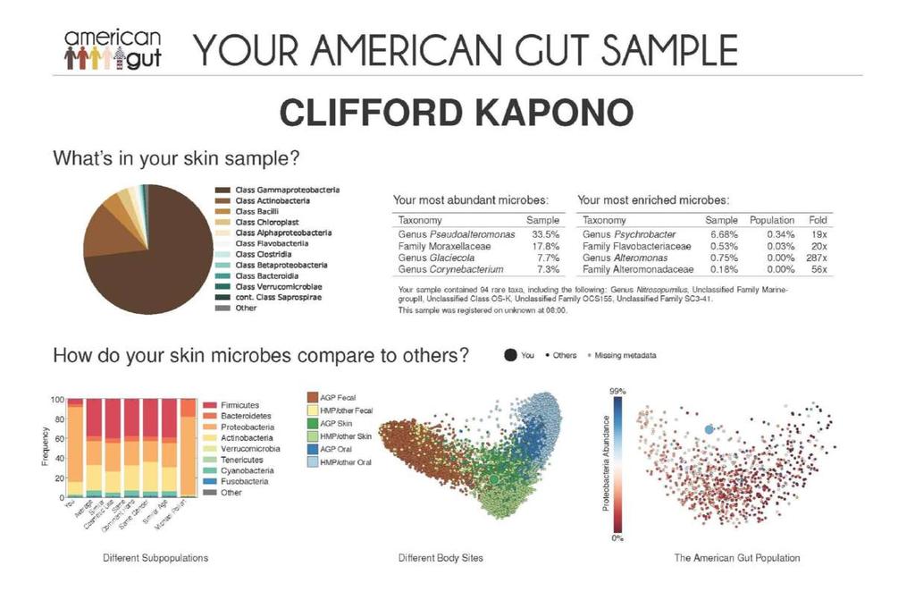
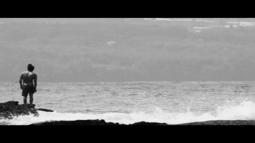
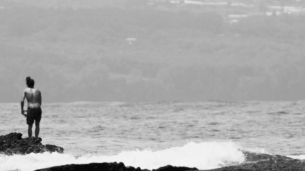
2 Cliff Kapono University of California, San Diego

3 THE SURFER BIOME PROJECT Cliff Kapono Global Wave Conference 2018 Santa Cruz, California

4 What does a relationship with nature look like?

5 How do we communicate this complex idea?
6
7

8
9

10 Nature s fingerprints on humans?

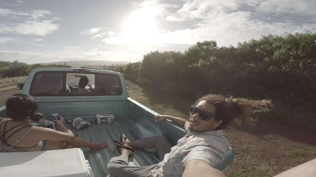
11 Who are the best guinea pigs? THE Surfers SURFER COMMUNITY
12
13


14 SAN DIEGO, USA PORTHLEVEN, ENGLAND


15
16
17


18 Mahalo Nui
19 Dr. Ali Boehm Stanford University

20 Oceans and human health Alexandria Boehm Dept. Civil & Environmental Engineering Stanford University 20

21 Water Sea spray Sand 10 6 bacteria per ml 10 7 viruses per ml
22 Pathogens in the beach microbiome Presence/ Absence of Salmonella spp. Punalu u Adv Entero Noro I Noro II Latitude Ma ili ili Ma ile Ka elepulu 34 Pacific Ocean Wai alae Longitude


23 Where do pathogens come from? Bather shedding Sewage outfalls Septic tanks via submarine groundwater discharge Runoff (storm, agricultural, and urban) Wildlife and humans feces Environmental reservoirs Wrack can harbor pathogens Wrack can harbor pathogens Runoff dyed with Rhodamine at Huntington 23
24 Swimmer epidemiology studies Does swimming in the ocean make you sick? Does swimmer illness correlate with fecal indicator bacteria concentrations? 1) Swimmers are at increase risk of illness compared to non-swimmers 2) Risk correlates to fecal indicator bacteria concentrations àdo results apply to surfers? (more exposure, more immunity) àdo results from one beach apply to other beaches?
25 Fecal indicator bacteria: E. coli and enterococci Risk of illness in swimmers Concentration of water quality indicator Correlate to risk of illness, used worldwide to assess beach water quality, basis of regulations


26 Over 20,000 beach closures and advisories in the US each year 26
27 Environmental variables affect beach water quality

28 Seasons and El Nino


29 Lunar cycles At 50/61 beaches examined in southern California, spring tides coincide with elevated ENT levels ENT = enterococci, MPN = most probable number
 100 9 8 7 6 5 4 3 2 TC = total coliform E")

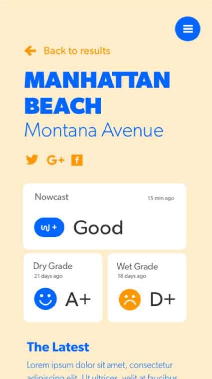
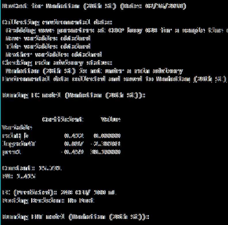
30 nasa.gov Solar modulation Data from Huntington Beach, CA (mpn/100 ml) TC = total coliform E EC = E. coli ENT = enterococci TC FC ENT 10 00:00 06:00 12:00 18:00 Time of Day


31 Future challenges and opportunities Striking lack of global data on coastal water quality Better measurement targets and methods Green infrastructure

32 Contact info Alexandria Boehm
33 Ryan Searcy Heal The Bay

34 The NowCast System Predicting Water Quality to Protect Surfer Health

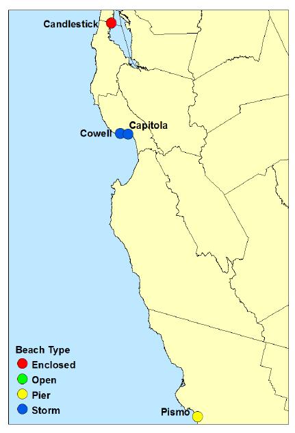
35 Why Predict Water Quality? 35

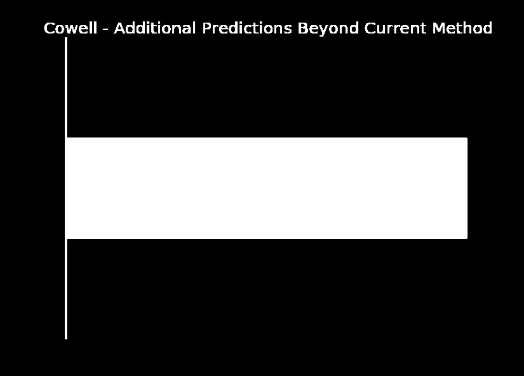
36 SCCWRP (Arnold et al., 2017)
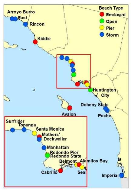
37 37


38 NowCast: Predicting Water Quality at California Beaches Rip Check NowCast Prediction NowCast 15 min ago Doheny State Beach

39 Creating NowCast Models 39


40 Initial Research Thoe et al., 2014


41 HYPERION SHORELINE BACTERIA SAMPLES DATA 41 CDIP

42 NowCast 15 min ago

43 Summer 2017 Beaches 43

44 Cowell Beach 124 Additional Predictions Beyond Sampling 44

45 Redondo Beach Pier 151 Additional Predictions Beyond Sampling

46 Doheny State Beach 163 Additional Predictions Beyond Sampling

47 Looking Forward Launch Website and App Aim: Memorial Day 2018 Add More Beaches to System Including Popular Surf Spots Future Research Modeling Data-Poor Beaches Forecasting Expand NowCast System Internationally Credit: Rude Boy Nick Sadrpour

48 Ryan Searcy Beach Water Quality Modeler x 111 rsearcy@healthebay.org Contact Info Acknowledgements: Dr. Ali Boehm - Stanford Dr. Mitzy Taggart - HTB Dr. Mark Gold - UCLA Dr. Wai Thoe - Hong Kong EPD CA State Water Resources Control Board Credit: Keo Publications available upon request
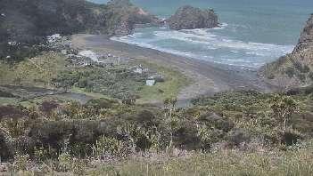
49 Dr. Ed Atkin ecoast
50 Remote Sensing, Classification and Management Guidelines for Surf Breaks of National and Regional Significance Ed Atkin 1,2, Terry Hume 3, Shaw Mead 1, Karin Bryan 2 and Jordan Waiti 4 1 ecoast, Raglan, New Zealand e.atkin@ecoast.co.nz 2 University of Waikato, Hamilton, New Zealand 3 Hume Consulting Ltd, Hamilton, New Zealand 4 Maori Health and Development, Raglan, New Zealand Global Wave Conference V Santa Cruz, March 5 th 2018 Maori Health & Development
51 GWC IV Messages: 1. The collection of data is imperative to surf break management and protection: With the latest video editing techniques and a crack team working round the clock

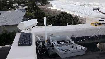
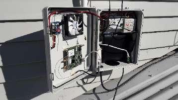
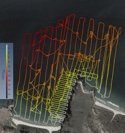
52 GWC IV Messages:

53 GWC IV Messages: 1. The collection of data is imperative to surf break management and protection: CLOSURE 2. A new project to study surf breaks in New Zealand
54 Remote Sensing, Classification and Management Guidelines for Surf Breaks of National and Regional Significance Ed Atkin 1,2, Terry Hume 3, Shaw Mead 1, Karin Bryan 2 and Jordan Waiti 4 1 ecoast, Raglan, New Zealand e.atkin@ecoast.co.nz 2 University of Waikato, Hamilton, New Zealand 3 Hume Consulting Ltd, Hamilton, New Zealand 4 Maori Health and Development, Raglan, New Zealand Global Wave Conference V Santa Cruz, March 5 th 2018 Maori Health & Development
55 Observations/Impetus There is a requirement in sustainable and adaptive management to have a clear and holistic understanding of the physical environment. Little to no data pertaining to the existing wave quality, breaking patterns, physical drivers, and the socioeconomic importance of New Zealand s surf breaks Managing coastal activities / impacts on the surf breaks, is extremely difficult. Resource managers struggling to give effect to the Resource Management Act 1991 and effectively uphold the intent of the NZCPS.
56 Remote Sensing, Classification and Management Guidelines for Surf Breaks of National and Regional Significance Funded By: Ministry Of Business, Innovation And Employment Fund: Targeted Research Priority: Enhanced Environmental Decision Making And Behaviour Change Project Components: 1. Study site selection 2. Collation of local and existing knowledge 3. Physical data collection 4. Data Analysis 5. Dissemination of data 6. Development of guidelines.
57 7 Study sites Representative of the New Zealand s Surf Break demographic: Boulder points Exposed west coast beach Learner/nursery ETD bar Focussing breaks Reef/Sand complex 1. Study Site Selection


58 Stakeholder Workshops Local/non-local Surfer/non-surfer Business owners etc. Māori and Pākehā Surveys, posters Geomorphological Assessments Literature Review: Journal articles Community group webpages Technical reports etc. 2. Collation of Local and Existing Knowledge


 How the voice")

59 2. Collation of Local and Existing Knowledge Real and Perceived Threats Increased of sand into the bay Sand locked up in the dunes Marina construction and maintenance dredging Port expansion and dredge disposal Boat ramps and breakwaters Runway extensions Water quality (land use / sewage) Sharing of space (other users) How the voice of local surfers is heard during decision making processes. Runway Extension Airport Rights


60 3/4. Physical Data Collection/Analysis Remote video imaging systems


61 3/4. Physical Data Collection/Analysis Remote video imaging systems Image Courtesy of POL Image Courtesy of POL


62 3/4. Physical Data Collection/Analysis Remote video imaging systems Georectification Measurement of features: Shoreline change Rip current occurrence Sandbar morphology Wave propagation characteristics New analysis techniques to determine surfing wave quality - peel angle. (courtesy of Harrison, 2015)

63 3/4. Physical Data Collection/Analysis Remote video imaging systems Georectification Measurement of features New analysis techniques to determine surfing wave quality - peel angle Quantifying big wave surfing height for Guinness Book of Records Frank Quirarte/Billabong.com (courtesy of Harrison, 2015)

64 3/4. Physical Data Collection/Analysis Hydrographic Surveys

65 3/4. Physical Data Collection/Analysis Hydrographic Surveys


66 3/4. Physical Data Collection/Analysis Numerical Modelling The influence of offshore features Ride lengths Break intensity Peel angle


67 3/4c. GPS Surfer Ride Data 21 Watches > Stakeholders Spatial definitions Model validation Combine with image analysis


68 5. Dissemination of Data Website Online Data Portal Journal Articles and Technical Reports 6. Develop Guidelines Provide Methods: Quantification of Surf Breaks Establishing Tolerance Levels How to Assess Potential Threats Mitigation Options Specify Minimum Study Requirements Case Studies Councils NGOs/Environmental Groups Developers Prospectors etc.
69 Thanks For Listening Kia Ora Maori Health & Development Acknowledgments: Steering Committee: Department of Conservation, Landcare Research, Surfbreak Protection Society, Surf Life Saving New Zealand, Waikato Regional Council, Auckland Council, and Lincoln University; all stakeholders for their input; and our sponsors Rip Curl and Vodafone
Re: Disposal of Maintenance Dredge Material and Impacts on Surfing Breaks and Coastal Processes.
 ecoast Marine Consulting and Research PO Box 151 Raglan, New Zealand. Ph. +64 21 423 224 www.ecoast.co.nz info@ecoast.co.nz 25 August 2015 Reuben Fraser Consents Manager Bay of Plenty Regional Council
The Surfer Health Study
 The Surfer Health Study Surfrider Foundation collaborated with scientists at Southern California Coastal Water Research Project (SCCWRP); University of California, Berkeley, School of Public Health; and
Pathogen Transport in Coastal Environments: Case Studies of Urban Runoff in Southern California
 Pathogen Transport in Coastal Environments: Case Studies of Urban Runoff in Southern California A presentation to the Center for Water Sciences MSU Pathogens Workshop, April 20, 2007 Stanley B. Grant Henry
California Health & Safety Code Requirement for Reporting of Sewage Spills
 Ocean Water Protection o Program OCCC 2007 Update Larry Honeybourne Health Care Agency Environmental Health Part 1: Sewage Spills and Closures Part 2: AB 411 Ocean & Bay Bacterial Monitoring Program Part
BEACH REPORT CARD. Overview of Heal the Bay's End of Summer Report Essential water quality information for beachgoers
 END OF SUMMER REPORT 2017 CALIFORNIA BEACH REPORT CARD Essential water quality information for beachgoers IN THIS REPORT Excellent Beach Grades Across Counties New Bacteria Standards Proposed for Local
The Dynamic Coast. Right Place Resources. A presentation about the interaction between the dynamic coast and people
 The Dynamic Coast Houses threatened by coastal erosion in California Right Place Resources A presentation about the interaction between the dynamic coast and people For the rest of the presentations in
TITLE: The Importance of Model Validation: Two Case Studies. AUTHOR:Julie Thomas. Scripps Institution of Oceanography, La Jolla, CA.
 TITLE: The Importance of Model Validation: Two Case Studies AUTHOR:Julie Thomas Scripps Institution of Oceanography, La Jolla, CA jothomas@ucsd.edu CO-AUTHOR: Corey Olfe Scripps Institution of Oceanography,
Future Condi,ons coastal hazard modeling and mapping
 Future Condi,ons coastal hazard modeling and mapping Presented by Bob Ba:alio, PE Environmental Science Associates, Inc. (ESA) On behalf of the physical processes team (USGS, TerraCosta- Scripps, ESA)
Ventura County. Open Pacific Coast Study. California Coastal Analysis and Mapping Project
 Ventura County Open Pacific Coast Study California Coastal Analysis and Mapping Project December 2011 Project Name: Meeting: Date and Time: Location: California Coastal Analysis and Mapping Project (CCAMP)/Open
A process based approach to understand WA s complex coastline Jeff Hansen Ryan Lowe Graham Symonds Laura Segura Gundula Winter
 A process based approach to understand WA s complex coastline Jeff Hansen Ryan Lowe Graham Symonds Laura Segura Gundula Winter WA s coastline is highly variable due to offshore and shore-attached coral
Beachgoers of Maine Who are they and what do they think about water quality
 Beachgoers of Maine Who are they and what do they think about water quality Ross Anthony 1a, Charles Colgan 1b, Caroline Noblet a, Kathleen Bell a 1 Presenting author, a University of Maine, b University
VENICE LOCAL COASTAL PROGRAM UPDATE: COASTAL HAZARDS WELCOME
 VENICE LOCAL COASTAL PROGRAM UPDATE: COASTAL HAZARDS WELCOME 1 Introducing the Team Hosted by the Department of City Planning and grant funded in part by the California Coastal Commission 2 Workshop Purpose
Wave Prediction in the Santa Barbara Channel
 Wave Prediction in the Santa Barbara Channel OCS Study MMS 2001-055 Final Technical Summary Final Study Report U.S. Department of the Interior Minerals Management Service Pacific OCS Region Wave Prediction
Coastal Environments Oceanographic and Engineering Expertise
 Coastal Environments Oceanographic and Engineering Expertise Coastal Environments La Jolla, CA www.coastalenvironments.com 14 May 2004 CE Ref. No. 04-05 EcoSystems Management Associates, Inc. Carlsbad,
Open Pacific Coast Study. California Coastal Analysis and Mapping Project
 Open Pacific Coast Study California Coastal Analysis and Mapping Project September 2012 California Open Coast Counties California Coastal Analysis and Mapping Project This publication is an initiative
Unit 11 Lesson 2 How Does Ocean Water Move? Copyright Houghton Mifflin Harcourt Publishing Company
 Unit 11 Lesson 2 How Does Ocean Water Move? Catch a Wave A wave is the up-and-down movement of surface water. Catch a Wave Catch a Wave (wave effects) Surface waves are caused by wind pushing against
Hamilton Public Health Services 2015 Beach Monitoring Report
 Page 1 of 6 Public Health Services Health Protection Division 110 King Street West, 2nd Floor, Hamilton, ON L8P 4S6 Phone: (905) 546-2424, ext. 3570 Fax: (905) 546-2787 Hamilton Public Health Services
Beach Wizard: Development of an Operational Nowcast, Short-Term Forecast System for Nearshore Hydrodynamics and Bathymetric Evolution
 Beach Wizard: Development of an Operational Nowcast, Short-Term Forecast System for Nearshore Hydrodynamics and Bathymetric Evolution Ad Reniers Civil Engineering and Geosciences, Delft University of Technology
GONE! Coastal Erosion Happens During Storms! Why Worry About Coastal Setbacks? Goals for Today
 RI Regulatory Setbacks & Buffers: Coastal Zone Management Issues New England Onsite Wastewater Training Program @ URI OWT 155 November 21, 2013 Goals for Today Understand the impacts of storms, coastal
RI Regulatory Setbacks & Buffers: Coastal Management Issues
 RI Regulatory Setbacks & Buffers: Coastal Management Issues New England Onsite Wastewater Training Program @ URI OWT 155 - November 29, 2012 James Boyd - Coastal Policy Analyst Photo: October 30, 2012
from a decade of CCD temperature data
 (Some of) What we have learned from a decade of CCD temperature data Craig Gelpi and Karen Norris Long Beach Aquarium of the Pacific August 15, 2008 Introduction Catalina Conservancy Divers collected temperature
Leaning Into Adaptation
 www.marinslr.org Leaning Into Adaptation GFNMS Ocean Summit, May 17, 2016 Jack Liebster, Planning Manager, Marin County Marin County C-SMART Sea Level Rise Adaptation Process Evaluate Science Info. Implement
Implications of changes to El Niño Southern Oscillation for coastal vulnerability in NSW
 Implications of changes to El Niño Southern Oscillation for coastal vulnerability in NSW By Thomas Mortlock (Thomas.mortlock@mq.edu.au) El Niño Southern Oscillation (ENSO) has a strong impact on weather
* 1 I am a person representing a relevant aspect of the public interest; or
 Further Submission on The Greater Wellington Natural Resources Plan Review. Please complete this form to make a further submission on the Proposed Natural Resources Plan for the Wellington Region (PNRP).
Hamilton Public Health Services 2014 Beach Monitoring Report
 Public Health Services Health Protection Division 110 King Street West, 2nd Floor, Hamilton, ON L8P 4S6 Phone: (905) 546-2424, ext. 3570 Fax: (905) 546-2787 Hamilton Public Health Services 2014 Beach Monitoring
Anatomy of Coastal Regions
 The Coast I. BEACH ANATOMY Anatomy of Coastal Regions Terms for different parts of beaches and coastal regions Are all about ENERGY- ie, where the ocean s energy Mostly through tides and waves, and shape
Prediction of Nearshore Waves and Currents: Model Sensitivity, Confidence and Assimilation
 Prediction of Nearshore Waves and Currents: Model Sensitivity, Confidence and Assimilation H. Tuba Özkan-Haller College of Oceanic and Atmospheric Sciences Oregon State University, 104 Ocean Admin Bldg
Nearshore Sediment Transport What influences the loss of sediment on Beaches? - Waves - Winds - Tidal Currents - River discharge - Runoff
 Tides & Beaches Nearshore Sediment Transport What influences the loss of sediment on Beaches? - Waves - Winds - Tidal Currents - River discharge - Runoff Oceans Ocean Topography Physical Structure of the
Bathing Water Directive. Ed Beard Defra Bathing Water Conference Southport March 2013
 Bathing Water Directive Ed Beard Defra Bathing Water Conference Southport March 2013 Revised Bathing Water Directive where are we going? where are we? where have we come from? 2 Compliance at coastal waters
1 Shoreline Erosion and Deposition
 CHAPTER 12 1 Shoreline Erosion and Deposition SECTION Agents of Erosion and Deposition BEFORE YOU READ After you read this section, you should be able to answer these questions: What is a shoreline? How
Assessment of flooding on low-elevation reef-lined coasts
 Assessment of flooding on low-elevation reef-lined coasts Ap van Dongeren, Deltares, Delft, The Netherlands With Curt Storlazzi, USGS, Santa Cruz, USA Impact on coral reef-lined islands and coasts Coral
30-Day Running Geometric Means for the Dana Point Harbor Stations for
 30-Day Running Geometric Means for the Dana Point Harbor Stations for 2000-2002 The following graphs provide the 30-day running geometric means for the Dana Point Harbor stations for total coliforms, fecal
Submission on the proposed New Zealand Coastal Policy Statement 2008 Sections 49 and 57 of the Resource Management Act 1991
 Submission on the proposed New Zealand Coastal Policy Statement 2008 Sections 49 and 57 of the Resource Management Act 1991 To: Board of Inquiry Proposed NZCPS C/- Department of Conservation PO Box 10
Pathways Interns: Annika O Dea, Ian Conery, Andrea Albright
 1 REMOTE SENSING OF COASTAL MORPHODYNAMICS 237 237 237 217 217 217 2 2 2 8 119 27 252 174.59 255 255 255 163 163 163 131 132 122 239 65 53 11 135 12 112 92 56 62 12 13 12 56 48 13 12 111 Kate Brodie Brittany
UC San Diego Scripps Institution of Oceanography Technical Report
 UC San Diego Scripps Institution of Oceanography Technical Report Title Categorizing the Types of Surfing Breaks around Jetty Structures Permalink https://escholarship.org/uc/item/09f405bq Authors Scarfe,
Marine Debris from Land to Sea: Holistic Characterization, Reduction and Education Efforts in New Hampshire
 Marine Debris from Land to Sea: Holistic Characterization, Reduction and Education Efforts in New Hampshire ABSTRACT Over time, the focus of marine debris research and work has shifted away from simply
CROSS-SHORE SEDIMENT PROCESSES
 The University of the West Indies Organization of American States PROFESSIONAL DEVELOPMENT PROGRAMME: COASTAL INFRASTRUCTURE DESIGN, CONSTRUCTION AND MAINTENANCE A COURSE IN COASTAL DEFENSE SYSTEMS I CHAPTER
City of Del Mar Local Coastal Plan (LCP) Amendment for Sea Level Rise and Coastal Flooding
 Amendment for Sea Level Rise and Coastal Flooding") City of Del Mar Local Coastal Plan (LCP) Amendment for Sea Level Rise and Coastal Flooding 6/22/17 Presentation to Sea Level Rise Stakeholder- Technical Advisory Committee (STAC) Nick Garrity, P.E. Lindsey
City of Del Mar Local Coastal Plan (LCP) Amendment for Sea Level Rise and Coastal Flooding 6/22/17 Presentation to Sea Level Rise Stakeholder- Technical Advisory Committee (STAC) Nick Garrity, P.E. Lindsey
OCEANS. Main Ideas. Lesson 2: Ocean Currents Ocean Currents help distribute heat around Earth.
 Oceans Chapter 10 OCEANS Main Ideas Lesson 2: Ocean Currents Ocean Currents help distribute heat around Earth. Lesson 3: The Ocean Shore The shore is shaped by the movement of water and sand. OCEANS SO
An IOOS Operational Wave Observation Plan Supported by NOAA IOOS Program & USACE
 An IOOS Operational Wave Observation Plan Supported by NOAA IOOS Program & USACE R.E. Jensen, W.A. Birkemeier and W. Burnett JCOMM-Workshop on Wave Measurements from Buoys Wave Information to Application
# Post Consultation and Submissions Resource Consent Conditions for Surfing Impact Mitigation August 2016
 # Post Consultation and Submissions Resource Consent Conditions for Surfing Impact Mitigation August 2016 Surf Mitigation Management Plan 1 1 Not less than 6 months prior to the commencement of the construction
Coastal and marine recreation in New England is ingrained in the region s economic and
 RECREATION Coastal and marine recreation in New England is ingrained in the region s economic and social fabric. Recreation on the ocean and coast includes many of New Englanders most time-honored and
Imagine that you can see a side view of a wave as it approaches a beach. Describe how the wave changes as the wave approaches the beach.
 Geology 101 Name Reading Guide for Ch. 19: Shores and Coastal Processes (p. 612) Waves, Currents, and Tides (p. 614) Waves and Currents (p. 614) Imagine that you can see a side view of a wave as it approaches
Volume and Shoreline Changes along Pinellas County Beaches during Tropical Storm Debby
 Volume and Shoreline Changes along Pinellas County Beaches during Tropical Storm Debby Ping Wang and Tiffany M. Roberts Coastal Research Laboratory University of South Florida July 24, 2012 Introduction
Collaboration: Sea-level Marin Adaptation Response Team (C-SMART)
") Collaboration: Sea-level Marin Adaptation Response Team (C-SMART) Photo Credit : Lighthawk Aerial Community Development Agency 3501 Civic Center Drive, Rm. 308 San Rafael, CA 94903 415 4736269 T www.marinslr.org
Collaboration: Sea-level Marin Adaptation Response Team (C-SMART) Photo Credit : Lighthawk Aerial Community Development Agency 3501 Civic Center Drive, Rm. 308 San Rafael, CA 94903 415 4736269 T www.marinslr.org
Surf Survey Summary Report
 Port Otago Limited 15 Beach Street Port Chalmers Surf Survey Summary Report August 13-September 1 Leigh McKenzie Summary of Surf Locations of Interest Port Otago Ltd is undertaking monitoring of changes
Surf zone entrainment, along-shore transport, and human health implications of pollution from tidal outlets
 JOURNAL OF GEOPHYSICAL RESEARCH, VOL. 110,, doi:10.1029/2004jc002401, 2005 Surf zone entrainment, along-shore transport, and human health implications of pollution from tidal outlets S. B. Grant, 1 J.
Redondo Beach Boat Launch Ramp Facility
 Redondo Beach Boat Launch Ramp Facility Feasibility Report for the California Department of Boating and Waterways 2015 Grant Cycle For the City of Redondo Beach Submitted by March 13, 2014 Table of Contents
An Update of Coastal Erosion in Puerto Rico
 Jack Morelock and Maritza Barreto An Update of Coastal Erosion in Puerto Rico Department of Marine Sciences, University of Puerto Rico at Mayagüez and Geography Department, University of Puerto Rico at
City of Encinitas Beach Attendance Report 2016
 City of Encinitas Beach Attendance Report 2016 Moonlight State Beach, July 2016 1 Introduction Since 2004, the City of Encinitas has intermittently employed counting technology to measure beach attendance.
Monitoring beach usage on Gold Coast beaches: Is it beneficial?
 Monitoring beach usage on Gold Coast beaches: Is it beneficial? Peta Williams 1, Gervase Tuxworth 2 and Chris Lane 2 1 Griffith Centre for Coastal Management (GCCM) Gold Coast Campus, Griffith University
INTRODUCTION TO COASTAL ENGINEERING
 The University of the West Indies Organization of American States PROFESSIONAL DEVELOPMENT PROGRAMME: COASTAL INFRASTRUCTURE DESIGN, CONSTRUCTION AND MAINTENANCE A COURSE IN COASTAL DEFENSE SYSTEMS I CHAPTER
Coastal management has lagged behind the growth in population leading to problems with pollution
 Fifty percent of the population of the industrialized world lives within 100 km of a coast. Coastal management has lagged behind the growth in population leading to problems with pollution and natural
Theory and Application Introductory Oceanography Ray Rector: Instructor
 OCEAN TIDES Theory and Application Introductory Oceanography Ray Rector: Instructor Tidal Concepts Tides are extremely swift, very long-wavelength, shallow-water waves Tides are periodic short-term changes
Environmental Protection on the Gold Coast of Queensland, Australia. 1. What is the appeal of the Gold Coast to tourists?
 Environmental Protection on the Gold Coast of Queensland, Australia Sections 1. What is the appeal of the Gold Coast to tourists? 2. How are Gold Coast visitor trends changing? 3. How can the impacts of
TIDES. Theory and Application
 TIDES Theory and Application Tidal Concepts Tides are extremely swift, very long-wavelength, shallow-water waves Tides are periodic short-term changes in sea level at a particular place caused by the gravitational
Heal the Bay s 2007 California Summer Beach Report Card SM
 Heal the Bay s 2007 California Summer Beach Report Card SM Heal the Bay s 2007 California Summer Beach Report Card provides beachgoers with essential water quality information by grading 494 monitoring
ADAPTATION TO SEA LEVEL RISE AND COASTAL IMPACTS
 ADAPTATION TO SEA LEVEL RISE AND COASTAL IMPACTS Miramar Inn, Half Moon Bay, March 1, 2014 Photo by Jack Sutton, all rights reserved 2/22/17 AdaptLA Workshop California Coastal Commission 2 Plans and regulates
Ocean Waves. Capillary. Gravity. Wind generated. Tides Tsunamis Seiches
 Ocean Waves Capillary Wind generated Gravity Tides Tsunamis Seiches Capillary waves are driven by the surface tension produced by electrically polarized water molecule San Pedro Lighthouse Waves are alternate
AMSA A Roadmap Forward & Relevant Alaska Activities. Captain Bob Pawlowski, NOAA (Ret), MNI Legislative Liaison to the Denali Commission
, MNI Legislative Liaison to the Denali Commission") AMSA A Roadmap Forward & Relevant Alaska Activities Captain Bob Pawlowski, NOAA (Ret), MNI Legislative Liaison to the Denali Commission Selected AMSA Key Findings UNCLOS: Fundamental framework IMO: Competent
AMSA A Roadmap Forward & Relevant Alaska Activities Captain Bob Pawlowski, NOAA (Ret), MNI Legislative Liaison to the Denali Commission Selected AMSA Key Findings UNCLOS: Fundamental framework IMO: Competent
Title: The Australian Public Coastal Safety Guidelines
 Title: The Australian Public Coastal Safety Guidelines Names of authors: Peter Agnew¹, Norman Farmer ESM ¹Surf Life Saving Australia ABSTRACT Guidelines and Standards for aquatic locations are nothing
Sea Level Rise in South Florida: Causes, Consequences and Opportunities
 Sea Level Rise in South Florida: Causes, Consequences and Opportunities Dr. Todd A. Crowl Director, Institute of Water & the Environment Director, Southeast Environmental Research Center Co-Founder, Sea
What are we adapting to? David Provis Senior Principal, Oceanography, Cardno Member, Victorian Coastal Council
 What are we adapting to? David Provis Senior Principal, Oceanography, Cardno Member, Victorian Coastal Council Sea-level -NOAA Sea-level - NOAA 90% probability ranges Sea-level - NOAA Sea-level Port Phillip
Update: UNSW s Research Program for Extreme Waves on Fringing Reefs. Matt Blacka,Kristen Splinter, Ron Cox
 Update: UNSW s Research Program for Extreme Waves on Fringing Reefs Matt Blacka,Kristen Splinter, Ron Cox Overview Research Area 1: Extreme wave and water level processes for fringing reef coastlines Research
MIKE Release General product news for Marine software products, tools & features. Nov 2018
 MIKE Release 2019 General product news for Marine software products, tools & features Nov 2018 DHI 2012 MIKE 3 Wave FM New advanced phase-resolving 3D wave modelling product A MIKE 3 FM Wave model - why?
Currents measurements in the coast of Montevideo, Uruguay
 Currents measurements in the coast of Montevideo, Uruguay M. Fossati, D. Bellón, E. Lorenzo & I. Piedra-Cueva Fluid Mechanics and Environmental Engineering Institute (IMFIA), School of Engineering, Research
Shorelines Earth - Chapter 20 Stan Hatfield Southwestern Illinois College
 Shorelines Earth - Chapter 20 Stan Hatfield Southwestern Illinois College The Shoreline A Dynamic Interface The shoreline is a dynamic interface (common boundary) among air, land, and the ocean. The shoreline
G. Meadows, H. Purcell and L. Meadows University of Michigan
 www.coj.net/departments/fire+and+rescue/emergency+preparedness/rip+current.htm G. Meadows, H. Purcell and L. Meadows Over 80% of all surf related rescues are attributable to Rip Currents According to the
Beach profile surveys and morphological change, Otago Harbour entrance to Karitane May 2014 to June 2015
 Beach profile surveys and morphological change, Otago Harbour entrance to Karitane May 2014 to June 2015 Prepared for Port Otago Ltd Martin Single September 2015 Shore Processes and Management Ltd Contact
Summary of Water Access for Marinas and Public Boat Ramps
 Lake Tahoe Shoreline Plan Meeting Materials: Steering Committee Last Updated: 11-28-16 Summary of Water Access for Marinas and Public Boat Ramps Table 1: Marinas Buoy Field Assessment Marinas 1. North
* 1 I am a person representing a relevant aspect of the public interest; or
 Further Submission on The Greater Wellington Natural Resources Plan Review. Please complete this form to make a further submission on the Proposed Natural Resources Plan for the Wellington Region (PNRP).
Longshore sediment transport
 and Orson P. Smith, PE, Ph.D., Professor Emeritus Longshore transport Waves breaking at an angle to shore Sediment under breakers lifted by saltation Drops back to sea bed a little down drift Swash (runup)
County of Santa Barbara Permit Option Analysis Goleta Beach JULY 13, 2017
 County of Santa Barbara Permit Option Analysis Goleta Beach JULY 13, 2017 Introduction 2 Goleta Beach Park welcomes 1.5 million visitors annually Amenities include: Picnic Areas and Group Areas w/bbqs
San Diego Coastal Ocean Observing System
 California Clean Beaches Initiative San Diego Coastal Ocean Observing System WWW.SDCOOS.ORG Presentation to Imperial Beach City Council August 3, 2005 Eric J. Terrill, Ph.D. Scripps Institution of Oceanography
Chapter 10 Lecture Outline. The Restless Oceans
 Chapter 10 Lecture Outline The Restless Oceans Focus Question 10.1 How does the Coriolis effect influence ocean currents? The Ocean s Surface Circulation Ocean currents Masses of water that flow from one
Taranaki Tsunami Inundation Analysis. Prepared for Taranaki Civil Defence Emergency Management Group. Final Version
 Taranaki Tsunami Inundation Analysis Prepared for Taranaki Civil Defence Emergency Management Group Final Version June 2012 AM 12/07 HBRC Plan Number 4362 Asset Management Group Technical Report Prepared
Where the Swell Begins
 Where the Swell Begins Walter Munk with Cher Pendarvis Swells to the horizon 2 Surfing is a gift, a total involvement that takes us away from other thoughts and the cares of the world... 3 The interaction
Inventory of coastal sandy areas protection of infrastructure and planned retreat
 2018-02-28 Inventory of coastal sandy areas protection of infrastructure and planned retreat Johanna Birgander, Thorbjörn Nilsson, Pär Persson Summary To estimate the natural protection around the coast
Technical Brief - Wave Uprush Analysis Island Harbour Club, Gananoque, Ontario
 Technical Brief - Wave Uprush Analysis RIGGS ENGINEERING LTD. 1240 Commissioners Road West Suite 205 London, Ontario N6K 1C7 October 31, 2014 Table of Contents Section Page Table of Contents... i List
Chapter. The Dynamic Ocean
 Chapter The Dynamic Ocean An ocean current is the mass of ocean water that flows from one place to another. 16.1 The Composition of Seawater Surface Circulation Surface Currents Surface currents are movements
LAB: WHERE S THE BEACH
 Name: LAB: WHERE S THE BEACH Introduction When you build a sandcastle on the beach, you don't expect it to last forever. You spread out your towel to sunbathe, but you know you can't stay in the same spot
Coastal Sediment Transport Modeling Ocean Beach & San Francisco Bight, CA
 1 Coastal Sediment Transport Modeling Ocean Beach & San Francisco Bight, CA Honghai Li and Lihwa Lin Engineering Research and Development Center U.S. Army Corps of Engineers Frank Wu, Lisa Andes, and James
ECAS 3 rd Periodic Activity Report; Publishable summary
 ECAS 3 rd Periodic Activity Report; Publishable summary Grant Agreement number: 312088 Project acronym: BENTHIS Project title: Funding Scheme: Collaborative project Project coordination: IMARES, IJmuiden,
Comparison of Predicted and Measured Shoaling at Morro Bay Harbor Entrance, California
 Comparison of Predicted and Measured Shoaling at Morro Bay Harbor Entrance, California by Edward F. Thompson, Inocencio P. DiRamos, and Robert R. Bottin, Jr. PURPOSE: This Coastal and Hydraulics Engineering
WATERWAYS AND HARBORS DIVISION Proceedings of the American Society of Civil Engineers. EQUILIBRIUM FLOW AREAS OF INLETS ON SANDY COASTS a
 6405 February, 1969 WWl J oumal of the WATERWAYS AND HARBORS DIVISION Proceedings of the American Society of Civil Engineers EQUILIBRIUM FLOW AREAS OF INLETS ON SANDY COASTS a By Morrough P. O'Brien,!
1 Shoreline Erosion and Deposition
 CHAPTER 12 1 Shoreline Erosion and Deposition SECTION Agents of Erosion and Deposition BEFORE YOU READ After you read this section, you should be able to answer these questions: What is a shoreline? How
Marine Stinger Management Newsletter
 Newsletter Vol. 1. No. 1 December 2005 In this Issue Launch of the Marine Stinger Newsletter!. 2 Mark the date: Calendar of upcoming events 2 Resources for coastal concerns.. 3 Resources for reef and island
Wave Transformation, Prediction, and Analysis at Kaumalapau Harbor, Lanai, Hawaii
 Wave Transformation, Prediction, and Analysis at Kaumalapau Harbor, Lanai, Hawaii Jessica H. Podoski, P.E. Coastal Engineer, USACE Honolulu District Christopher Goody, P.E. Sea Engineering, Inc. Thomas
On the role of Posidonia oceanica on Mediterranean beaches
 Water Wave Mechanics and Coastal Engineering Imposición Medalla como Académico Correspondiente de la RAI al Prof. R.A. Dalrymple On the role of Posidonia oceanica on Mediterranean beaches Lluís GÓMEZ-PUJOL
Ocean Waves and Surf Forecasting: Wave Climate and Forecasting
 Overview Ocean Waves and Surf Forecasting: Wave Climate and Forecasting Ocean regions Characterizing and describing ocean waves Wave theory, propagation, and dispersion Refraction, shadowing, and bathymetry
Climate Change Impacts to KSC Launch Complex
 Climate Change Impacts to KSC Launch Complex Presented to: 2010 International Workshop on Environment and Energy By: John Shaffer NASA Environmental Management Branch Kennedy Space Center Hurricane Season
Whose Beach Is It Anyway? Managing Seals at Children s Pool, La Jolla CA. James H. Lecky Southwest Region, National Marine Fisheries Service
 Whose Beach Is It Anyway? Managing Seals at Children s Pool, La Jolla CA James H. Lecky Southwest Region, National Marine Fisheries Service Harbor seals have been hauling out and pupping on a public beach
Healthy Swimming: Prevention of Recreational Water Illnesses (RWIs)
") Healthy Swimming: Prevention of Recreational Water Illnesses (RWIs) Q u e s t i o n s a n d A n s w e r s f o r A q u a t i c s F a c i l i t y S t a f f The following information about recreational water
Healthy Swimming: Prevention of Recreational Water Illnesses (RWIs) Q u e s t i o n s a n d A n s w e r s f o r A q u a t i c s F a c i l i t y S t a f f The following information about recreational water
OCEAN WAVES NAME. I. Introduction
 NAME OCEAN WAVES I. Introduction The physical definition of a wave is a disturbance that transmits energy from one place to another. In the open ocean waves are formed when wis blowing across the water
Recreational Uses of St Marys Bay and Masefield Beach Panuku Development Auckland
 Appendix D Recreational Uses of St Marys Bay and Masefield Beach Panuku Development Auckland Beca // 2 May 2018 4216571 // NZ1-15242655-52 0.52 // page 133 Recreational uses of St Marys Bay and Masefield
Issues facing this region include the status of the Sluice Creek tide gates, various tidal wetlands, and locations of public access:
 5.6 Guilford Point to Madison Town Line Existing Resources This region extends from Guilford Point to the Madison town line. Named places include Grass Island and the East River. Residential, commercial,
BILLY BISHOP TORONTO CITY AIRPORT PRELIMINARY RUNWAY DESIGN COASTAL ENGINEERING STUDY
 Bâtiment Infrastructures municipales Transport Industriel Énergie Environnement BILLY BISHOP TORONTO CITY AIRPORT PRELIMINARY RUNWAY DESIGN COASTAL ENGINEERING STUDY N. Guillemette 1, C. Glodowski 1, P.
Tsunamis. Tsunamis COMMUNITY EMERGENCY RESPONSE TEAM TSUNAMIS
 Tsunamis Tsunamis Tell the participants that tsunamis are ocean waves that are produced by underwater earthquakes or landslides. The word is Japanese and means harbor wave because of the devastating effects
Mechanisms and Characteristics of High-Speed Reef Rip Current
 Mechanisms and Characteristics of High-Speed Reef Rip Current Ryuichiro Nishi, Mario P. de Leon, Kouji Horinouchi,Akira Ohtani, Nicholas C. Kraus, and Julianti K. Manu Many people utilize beaches, but
Shoreline Response to an Offshore Wave Screen, Blairgowrie Safe Boat Harbour, Victoria, Australia
 Shoreline Response to an Offshore Wave Screen, Blairgowrie Safe Boat Harbour, Victoria, Australia T.R. Atkins and R. Mocke Maritime Group, Sinclair Knight Merz, P.O. Box H615, Perth 6001, Australia ABSTRACT