NRC Publications Archive Archives des publications du CNRC
|
|
|
- Annabella Horton
- 6 years ago
- Views:
Transcription

1 NRC Publications Archive Archives des publications du CNRC Documenting Ice in the Bay of Fundy Canada Sanders, R.; Baddour, R. E. For the publisher s version, please access the DOI link below./ Pour consulter la version de l éditeur, utilisez le lien DOI ci-dessous. NRC Publications Record / Notice d'archives des publications de CNRC: Access and use of this website and the material on it are subject to the Terms and Conditions set forth at READ THESE TERMS AND CONDITIONS CAREFULLY BEFORE USING THIS WEBSITE. L accès à ce site Web et l utilisation de son contenu sont assujettis aux conditions présentées dans le site LISEZ CES CONDITIONS ATTENTIVEMENT AVANT D UTILISER CE SITE WEB. Contact us / Contactez nous: nparc.cisti@nrc-cnrc.gc.ca.
2 National Research Council Canada Institute for Ocean Technology Conseil national de recherches Canada Institut des technologies océaniques Contractor Report CR Documenting Ice in the Bay of Fundy Canada R. Saunders and R. E. Baddour March 2006
3 DOCUMENTATION PAGE REPORT NUMBER NRC REPORT NUMBER DATE CR REPORT SECURITY CLASSIFICATION Unclassified TITLE March 2006 DISTRIBUTION Unlimited DOCUMENTING ICE IN THE BAY OF FUNDY CANADA AUTHOR(S) Richard Sanders 1 and Emile Baddour 2 CORPORATE AUTHOR(S)/PERFORMING AGENCY(S) 1 Resource Manage Inc., Halifax, NS 2 Institute for Ocean Technology, National Research Council, St. John s, NL PUBLICATION SPONSORING AGENCY(S) Institute for Ocean Technology, National Research Council, St. John s, NL IOT PROJECT NUMBER NRC FILE NUMBER 42_2135_16 KEY WORDS energy harvest, tidal currents, sea ice PAGES 22, App. A-B FIGS. 11 TABLES 1 SUMMARY Sea ice capable of impacting marine operations occurs periodically in the most favourable sites for energy harvest from the tidal currents of the Bay of Fundy in Nova Scotia and New Brunswick. In-stream tidal current harvesting devices deployed at these sites will need to be engineered to tolerate at least 30% cover of sea ice 15 cm thick in floes of at least 100 metres in length. Propelled by tidal currents and prevailing winds, these floes may achieve velocities in excess of 8 knots in some locations. In very severe winters, in-stream tidal current harvesting devices may be subjected to periods of 70% cover of cm rapidly moving or packed sea ice. Additional research is necessary to characterize tidal currents in the presence of ice and to design devices which can tolerate the sea ice conditions in the headwaters of the Bay of Fundy, one of North America s greatest tidal power resources. Once ice-tolerant tidal current harvesting devices are developed, they may be deployable in other jurisdictions with energetic tidal flows which experience more severe conditions of sea ice than the headwaters of the Bay of Fundy. In North America, these locations might include Northumberland Strait (between Prince Edward Island and New Brunswick), the Gulf of St. Lawrence (Quebec), the Strait of Belle Isle (Newfoundland and Labrador), Cook Inlet (Alaska), and Ungava Bay (Quebec). Beyond the North American Continent, a market for ice-tolerant tidal current harvesting technology may exist in other circumpolar jurisdictions with energetic tidal flows. ADDRESS National Research Council Institute for Ocean Technology Arctic Avenue, P. O. Box St. John's, NL A1B 3T5 Tel.: (709) , Fax: (709)
4 National Research Council Conseil national de recherches Canada Canada Institute for Ocean Technology Institut des technologies océaniques DOCUMENTING ICE IN THE BAY OF FUNDY CANADA CR Richard Sanders and Emile Baddour March 2006
5 ABCB BDBB EFBBB FFFB As a Preliminary to Developing Ice-Tolerant In-Stream Tidal Current Harvesting Devices by Richard Sanders, Ph.D. Resource Manage Inc. Box Halifax, NS B3M 4H4 Canada Phone (902) Facsimile (902) reourcemanage@eastlink.ca in collaboration with Emile Baddour, Ph.D. NRC Institute of Ocean Technology Arctic Avenue St. John s, NL A1b 3T5 Canada Phone (709) emile.baddour@nrc.ca
6 ACKNOWLEDGEMENTS The authors would like to thank the Institute for Ocean Technology of the National Research Council Canada and the Ocean Energy Technology Review Project of Natural Resources Canada and Industry Canada for the opportunity to research and compile the data presented in this report. We would also like to thank Environment Canada and the Canadian Ice Service for their assistance in preparing this report. We wish to express our gratitude to the Electric Power Research Institute for making preliminary drafts of the Institute s tidal energy studies publicly available. The authors would also like to thank Mr. George C. Baker, former Vice-President of the [Nova Scotia] Tidal Power Corporation, for informal discussion with us and for his contributions to the development of tidal power in the Bay of Fundy over the last four decades. The first author would like to express his gratitude to the many individuals who shared their knowledge of ice conditions in the Bay of Fundy with him during the preparation of this report.
7 SUMMARY Sea ice capable of impacting marine operations occurs periodically in the most favourable sites for energy harvest from the tidal currents of the Bay of Fundy in Nova Scotia and New Brunswick. In-stream tidal current harvesting devices deployed at these sites will need to be engineered to tolerate at least 30% cover of sea ice 15 cm thick in floes of at least 100 metres in length. Propelled by tidal currents and prevailing winds, these floes may achieve velocities in excess of 8 knots in some locations. In very severe winters, in-stream tidal current harvesting devices may be subjected to periods of 70% cover of cm rapidly moving or packed sea ice. Additional research is necessary to characterize tidal currents in the presence of ice and to design devices which can tolerate the sea ice conditions in the headwaters of the Bay of Fundy, one of North America s greatest tidal power resources. Once ice-tolerant tidal current harvesting devices are developed, they may be deployable in other jurisdictions with energetic tidal flows which experience more severe conditions of sea ice than the headwaters of the Bay of Fundy. In North America, these locations might include Northumberland Strait (between Prince Edward Island and New Brunswick), the Gulf of St. Lawrence (Quebec), the Strait of Belle Isle (Newfoundland and Labrador), Cook Inlet (Alaska), and Ungava Bay (Quebec). Beyond the North American Continent, a market for ice-tolerant tidal current harvesting technology may exist in other circumpolar jurisdictions with energetic tidal flows. i
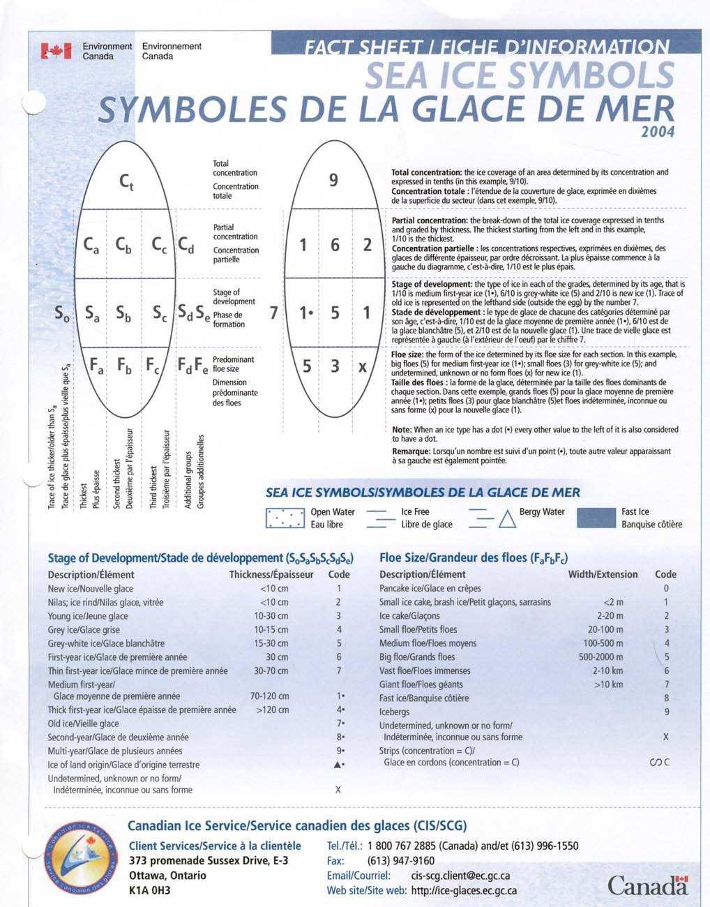
8 CONTENTS I. Introduction. 1 II. Documenting Ice in the Bay of Fundy.. 9 A. Data from B. Data from C. Data from D. Impressions of an Eye Witness.. 13 E. Findings. 14 III. Harvesting Tidal Current Power in the Presence of Sea Ice A. Introduction.. 16 B. Impact of sea ice on the tidal current resource. 16 C. Impact of sea ice on access to the tidal current resource. 16 D. Physical contact between the harvesting device and sea ice 16 E. Conclusion 20 IV. References.. 20 V. Appendices. 22 A. Appendix One 1. Environment Canada Fact Sheet: Sea Ice Symbols 2. Canadian Ice Service Regional Ice Analyses: Eastern Coast Selected data B. Appendix Two Report to Atlantic Tidal Power Programming Board on Feasibility of Tidal Power Development in the Bay of Fundy: Appendix 3 Ice and Sediment by Atlantic tidal Power Engineering and Management Committee, Halifax, Nova Scotia, Canada, October, 1969, pages ii
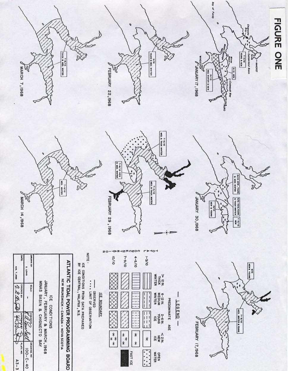
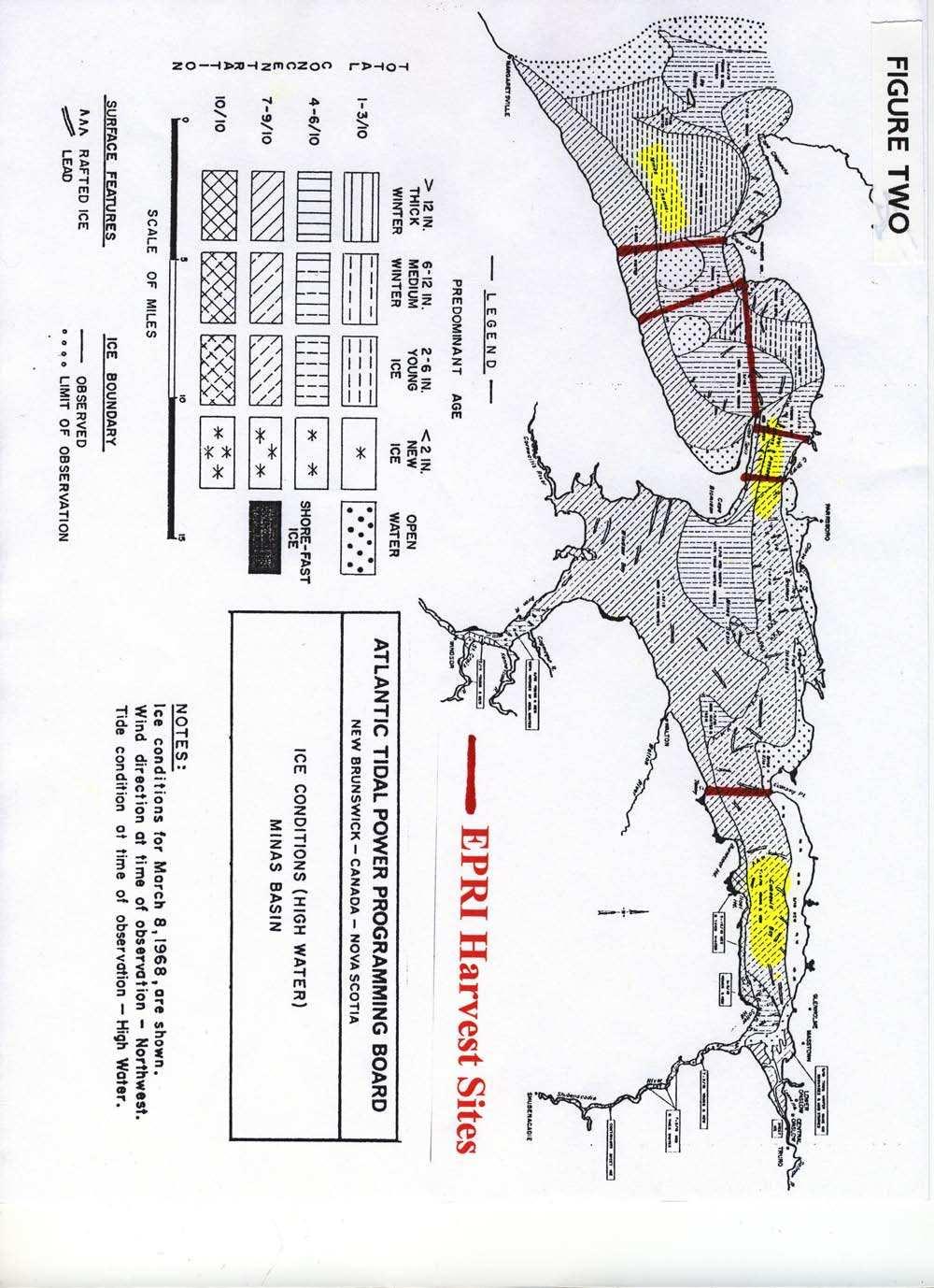
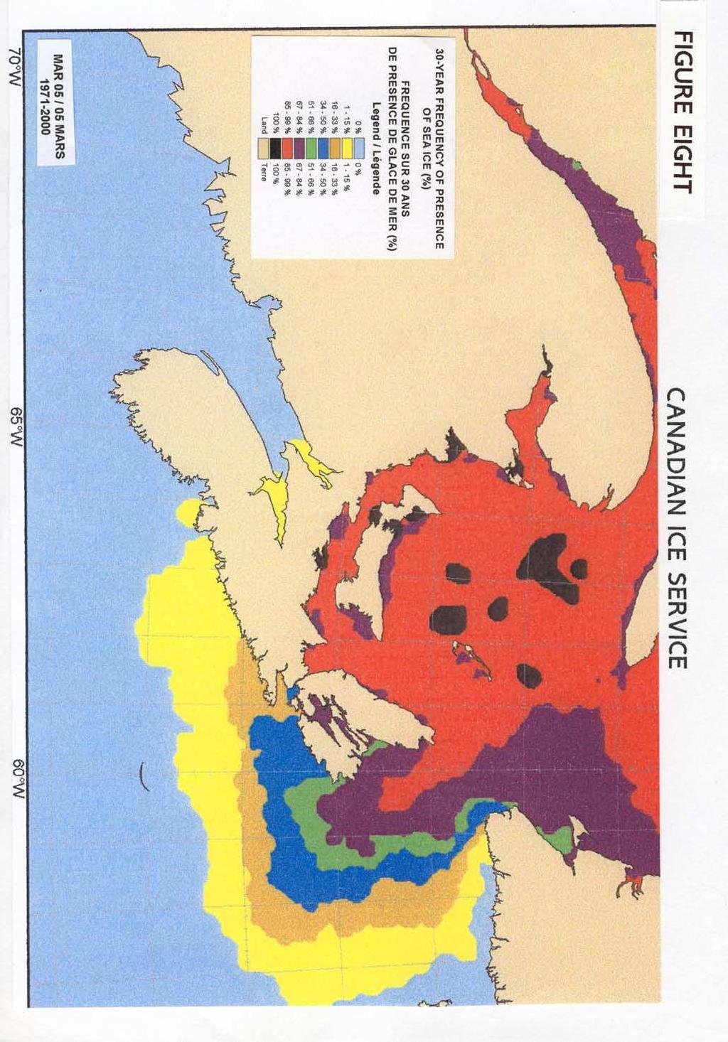
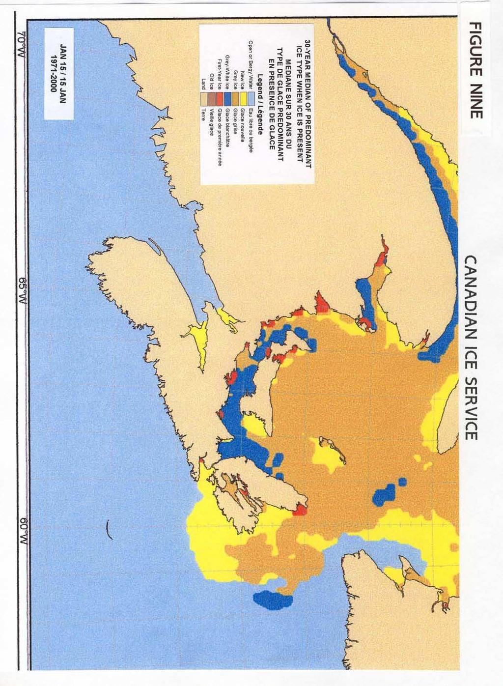
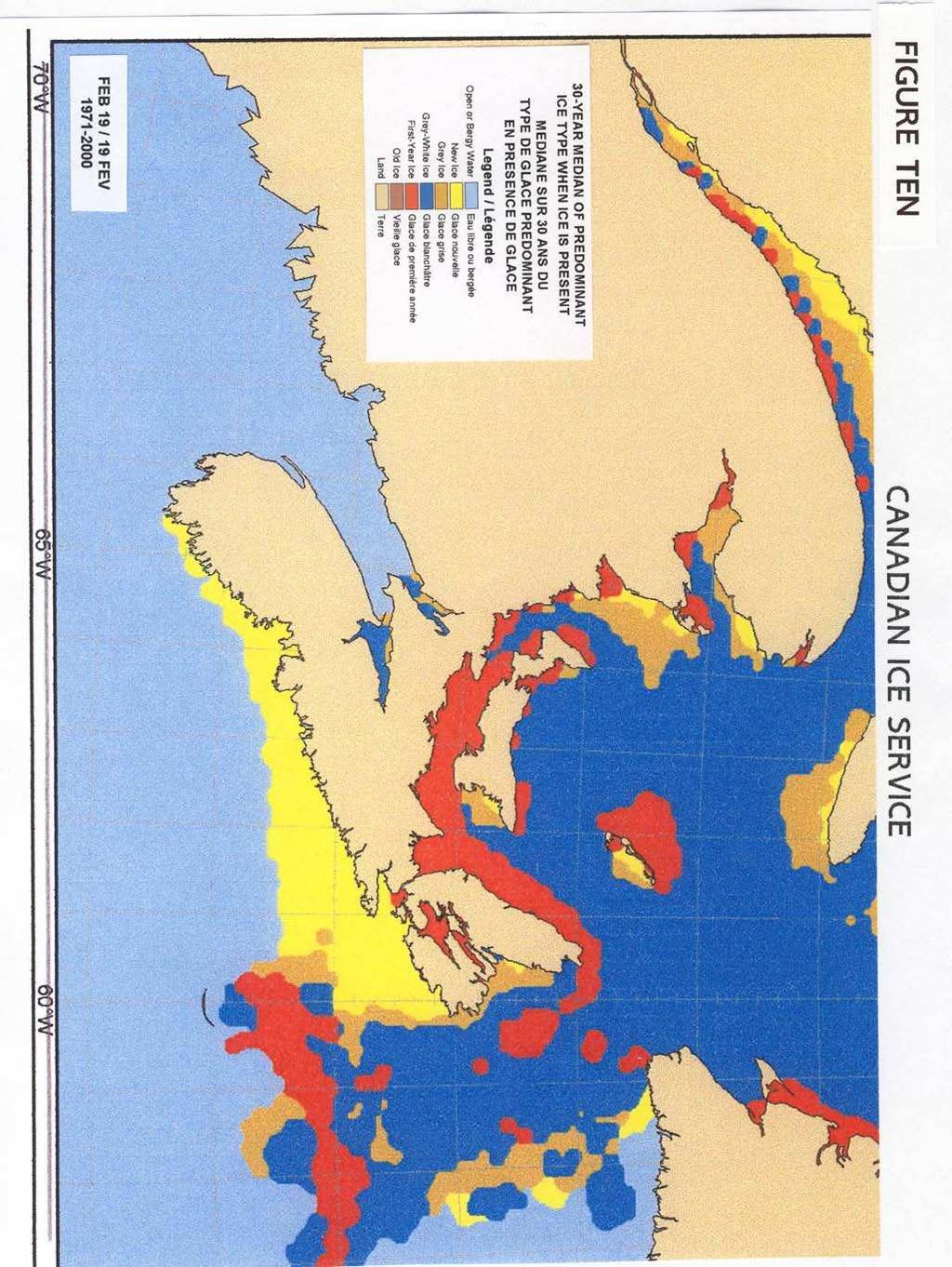
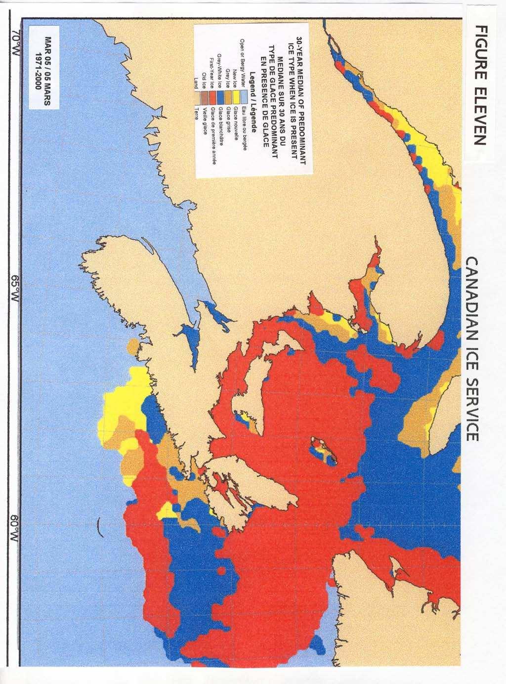
9 List of Figures Figure One: Sea Ice Conditions in the Bay of Fundy Headwaters in January, February and March 1968, between pages 9 & 10. Figure Two: Sea Ice Conditions in the Minas Branch of the Bay of Fundy on March 8, 1968, between pages 9 & 10. Figure Three: Sea Ice Conditions in the Chignecto Branch of the Bay of Fundy on March 8, 1968, between pages 9 & 10. Figure Four: Sea Ice Conditions in the Western Section of the Minas Branch of the Bay of Fundy on March 8, 1968, between pages 9 & 10. Figure Five: Sea Ice Conditions in the Eastern Section of the Minas Branch of the Bay of Fundy on March 8, 1968, between pages 9 & 101. Figure Six: 30-Year Frequency of Presence of Sea Ice (%), Canadian Ice Service, South Eastern Coastal Region, January 15, , between pages 11 & 12. Figure Seven: 30-Year Frequency of Presence of Sea Ice (%), Canadian Ice Service, South Eastern Coastal Region, February 19, , between pages 11 & 12. Figure Eight: 30-Year Frequency of Presence of Sea Ice (%), Canadian Ice Service, South Eastern Coastal Region, March 5, , between pages 11 & 12. Figure Nine: 30-Year Median of Predominant Ice Type When Ice is Present, Canadian Ice Service, South Eastern Coastal Region, January 15, , between pages 12 & 13. Figure Ten: 30-Year Median of Predominant Ice Type When Ice is Present, Canadian Ice Service, South Eastern Coastal Region, February 19, , between pages 12 & 13. Figure Eleven: 30-Year Median of Predominant Ice Type When Ice is Present, Canadian Ice Service, South Eastern Coastal Region, March 5, , between pages 12 & 13. List of Photographs Photograph One: The Minas Passage, p. 5. iii
10 List of Satellite Images Satellite Image One: Atlantic Canada, p. 3. Satellite Image Two: Bay of Fundy Headwaters, p. 4. Satellite Image Three: Some North American Tidal Current Sites With Sea Ice, p. 19. List of Tables Table One: Sea Ice in the Bay of Fundy at Sites With Harvestable Tidal Currents, p. 6. Abbreviations cm EPRI MW MPH NB NL NS NSPI PEI PQ USA centimetre Electric Power Research Institute Megawatt Miles per hour New Brunswick Newfoundland and Labrador Nova Scotia Nova Scotia Power Incorporated Prince Edward Island Province of Quebec United States of America iv
11 -1- I. Introduction Abundant energy is the foundation of modern civilization. In this century, new sources of energy must be found to replace oil and gas, which are increasingly problematic to extract from the earth s crust, to transport to affluent consumers and to utilize without untoward environmental consequences. A portion of the energy we obtain from burning oil and gas could be replaced by emerging technologies which convert the kinetic energy of moving water into electricity. Some of these devices convert the movement of waves into electricity (1,2). Others convert the flow of tidal currents, rivers and other natural and artificial waterways into electricity (3,4,18,20,22). It is theoretically possible that electricity harvested from moving water could significantly reduce dependence on oil and gas for electricity generation, transportation and, possibly, space heating. For example, part or all of the electricity generated by burning gas (or oil) might be replaced by electricity generated by moving water in jurisdictions with appropriate water resources. In addition, the dependence of transportation on oil could be diminished if vehicles are powered by electricity generated by moving water or by hydrogen made from the electricity harvested from moving water. Finally, under certain economic conditions, oil or gas space heating might be replaced by electric space heating using electricity generated by moving water. In Atlantic Canada (see Satellite Image One, p. 3) the most obvious undeveloped resource of moving water is the tidal flow in the headwaters of the Bay of Fundy (see Satellite Image Two, p. 4). For example, every six hours a volume of water traverses the Minas Passage (see Photograph One, p.5) that is equivalent to the five-day flow of the St. Lawrence River at Cornwall, Ontario (reference 5, Volume One, page 8). In addition, the Electric Power Research Institute (EPRI), under contract to the Provinces of Nova Scotia and New Brunswick to inventory the tidal current resources in these two jurisdictions, found that the tidal currents in the Minas region of the head waters of the Bay of Fundy are among the most promising sites in North America for tidal energy harvest (6,7). Interest in converting energy from the Fundy tides into electricity is not new. Over the last century, plans to harvest both the potential energy and the kinetic energy of the Fundy tides have been advanced. From the early 1900 s to the 1980 s numerous schemes were proposed, both in Canada and the United States, to capture the potential energy of the Fundy high tides using barrages, or dams (14). In the early 1980 s, a 20 MW pilot barrage project was completed at Annapolis Royal, Nova Scotia (13,14). Today the Annapolis Royal Tidal Generating Station remains the second largest grid-
12 -2- connected tidal power installation in the world. However, both the capital cost and environmental impact of this tidal power station have deterred the construction of larger facilities based on similar technology. One very positive result of the historical interest in barrage technology is a feasibility study done in the late 1960 s by the governments of New Brunswick, Nova Scotia and Canada. The report of this study, entitled Report to Atlantic Tidal Power Programming Board on Feasibility of Tidal Power Development in the Bay of Fundy (5), contains approximately 1500 pages of information on the Fundy region, including the most comprehensive descriptions of the sea ice conditions in the Bay of Fundy headwaters available (see reference 5, Satellite Image Two (p. 4), Figures One-Five and Appendix Two). A device to convert the kinetic energy of the tidal currents in the Bay of Fundy into electricity was developed about 90 years ago.* Between 1915 and the early 1920 s, Ralph P. Clarkson, a physics professor at Acadia University in Wolfville, Nova Scotia, and several colleagues designed, patented and tested what was perhaps the world s first in-stream tidal current device, the Clarkson Current Turbine (23). This device was to be installed in the Minas Passage (see Photograph One,p. 5, and Satellite Image One, p. 3) to produce electricity for the Nova Scotia power grid at Cape Split. Unfortunately, the wooden prototype, which had been successfully tested, caught fire in 1920, and there was insufficient venture capital to replace it. Professor Clarkson was certainly prescient in his proposal to harvest electricity from the tidal flow in the Minas Passage some 90 years ago. Today s emerging technologies (3,4,18,20,22) are in principle similar to the Clarkson Current Turbine (24). These modular technologies are designed to convert the kinetic energy of flowing water into electricity with relatively minor environmental impacts and at much lower capital costs than barrages. However, to harvest the huge tidal energy resource in the headwaters of the Bay of Fundy, including the Minas Passage, these in-stream tidal current harvesting devices must be able to tolerate the seasonal presence of sea ice (see below, sections II and III). We document here the occurrence of sea ice in the sites on the Bay of Fundy in New Brunswick and Nova Scotia most suitable for tidal energy harvest. We recommend the development of sea-ice tolerant in-stream tidal current devices for deployment in the Bay of Fundy and, subsequently, in tidal-rich jurisdictions with more severe conditions of sea ice, in order to harvest the global resources of this alternative energy source. * Underflow water wheels harvesting kinetic energy from the in-coming Fundy tide probably operated prior to This technology was used to generate mechanical energy, rather than electricity, and is not discussed here.

13 -3- Satellite Image One Atlantic Canada Legend to Satellite Image One A view of Atlantic Canada. Provincial jurisdictions and several locations having potential for tidal energy harvest are indicated. NB= New Brunswick; NL= Newfoundland and Labrador; NS= Nova Scotia; PEI= Prince Edward Island; PQ= Province of Quebec. Modified from Google Earth (17).

14 -4- Satellite Image Two Bay of Fundy Headwaters Legend to Satellite Image Two A view of the headwaters of the Bay of Fundy with the major tidal power sites included. Shepody Bay and Cape Enrage are located in the province of New Brunswick. Cobequid Bay, the minas Passage and the Minas Channel are located in the province of Nova Scotia. The Cumberland Basin is shared by both New Brunswick and Nova Scotia. The location of the town of Hantsport, Nova Scotia, is indicated for reference in section III.,D., this report. Modified from Google Earth (17).

15 -5- Photograph One THE MINAS PASSAGE (See Table One) Legend to Photograph One The region between Cape Sharp and Cape Split is known as the Minas Passage. Every 6 hours and 12 ½ minutes an estimated 105 billion cubic feet of water traverses the Minas Passage. This is equal to the 5 day flow of the St. Lawrence River at Cornwall, Ontario (ref. 5, Volume 1, page 8). The Electric Power Research Institute (EPRI) has described the Minas Passage as the most energetic tidal power site in the Bay of Fundy, and perhaps the most energetic site in North America (Table One and reference 6 pages 3 and 14; reference 7, page 11). Photo: Ron Garnett AirScapes ; used with permission.
16 -6- Table One SEA ICE IN THE BAY OF FUNDY AT SITES WITH HARVESTABLE TIDAL CURRENTS Site* Energy Harvest* Sea Ice** Minas Passage 333 MW Yes Nova Scotia Minas Channel 262 MW Yes Nova Scotia Cape Enrage 30 MW Yes New Brunswick Petit Passage 18 MW No Nova Scotia Head Harbour Passage 14 MW No New Brunswick Shepody Bay 13 MW Yes New Brunswick Cumberland Basin 13 MW Yes NS/NB Cobequid Bay 13 MW Yes Nova Scotia Grand Passage 13 MW No Nova Scotia Western Passage 10.8 MW No New Brunswick Digby Gut 9.8 MW No Nova Scotia Letete Passage 4.2 MW No New Brunswick Lubec Narrows 1.2 MW No New Brunswick St. John River, NB [Not Reported by EPRI] No * The Electric Power Research Institute (EPRI), under contract to the governments of New Brunswick and Nova Scotia, has identified the fourteen sites listed in Table One in New Brunswick and Nova Scotia on the Bay of Fundy as having harvestable tidal currents (6,7). The Energy Harvest data presented in column two are also from EPRI (6,7) and are used here only to indicate the energy resource size at the various sites relative to one another (see below, Legend to Table One, subsection entitled Energy Harvest. ** Data from The Canadian Ice Service, Ice Archive (reference 12 and Appendix One, this document) and Report to Atlantic Tidal Power Programming Board on Feasibility of Tidal Power Development in the Bay of Fundy, Appendix 3, Ice and Sediment, by the Atlantic Tidal Power Programming Board, October, 1969 (reference 5 and Appendix Two, this document).
17 -7- Legend to Table One The most promising sites for tidal current harvest in the Bay of Fundy in New Brunswick and Nova Scotia are presented in column one of Table One. These sites are listed from the most energetic to least energetic. The sites presented in red periodically experience sea ice capable of impacting marine activities. Sea Ice The Minas Passage, the Minas Channel, Cape Enrage, Shepody Bay, the Cumberland Basin and Cobequid Bay all periodically experience 30% cover of sea ice 15 cm thick in floes of at least 100 metres in length (see Appendix One and section II.,E.,1., p. 14, this document). These ice floes may move under the influence of tidal currents which can exceed 7 knots and sustained winds which can exceed 50 MPH (reference 5, Appendix 4). During very severe winters, the red sites in Table One may experience 70% cover with ice greater than 30 cm in thickness (reference 5 and Appendix Two, pages A3-4 and A3-17). Inspection of the red sites in Table One reveals that approximately ninety percent of the harvestable tidal current energy in the Bay of Fundy in Nova Scotia and New Brunswick occurs at sites which experience sea ice capable of impacting marine operations. In-stream tidal current harvesting devices in the Minas Channel and the Minas Passage, as well as those at Cape Enrage and in Cobequid Bay, Shepody Bay and the Cumberland Basin should be designed to tolerate the conditions of sea ice occurring at these sites during January, February and March of some years. Please note that Table One is a minimal statement of the winter ice conditions in the Bay of Fundy. The word No in column three of Table One means that sea ice has not been reported at a site in the references used to prepare Table One. However, ice in the Bay of Fundy has historically been under-reported to the Canadian Ice Service (see below, section II., C. Data from , p. 11, this document), and it is possible that ice occasionally occurs at the sites represented in Table One as having no sea ice.
18 -8- (Legend to Table One, cont.) Energy Harvest The work by EPRI to calculate the size of tidal current resources (6,7) is pioneering, but should be confirmed in field studies. For this reason, the energy harvest data presented in column two are used only to indicate the approximate energy resource size at the various sites relative to one another. Uncertainty in EPRI s energy harvest numbers is suggested by the variety of assumptions used in their calculation. Some of these assumptions underlie the calculation of the size of the tidal current resource at each site. Other assumptions are used in the calculation of the percentage of the tidal current energy which can be harvested without untoward environmental or ecological impacts. Additional assumptions are based on the performance of the latest generation of tidal current harvesting devices, most of which have not been deployed in full scale and none of which has been installed at the device densities used in EPRI s energy harvest calculations. For additional discussion of the assumptions used in EPRI s pioneering calculations of tidal energy, please see reference 21. We would, of course, like to know the potential contribution of tidal current power to society s electrical requirements (see Introduction, paragraph three, p. 1, this document). Consider, for example, the jurisdiction of Nova Scotia, where Nova Scotia Power Incorporated (NSPI) provides more than 97% of the province s electric generation, using 2,293 MW of installed capacity (13). Twenty seven percent of this generating capacity utilizes oil and gas (13). It is not inconceivable that in Nova Scotia the electricity generated from the two most energetic sites in the Bay of Fundy, the Minas Channel and the Minas Passage, could replace the electricity presently obtained from oil and gas, supplies of which are likely to be exhausted in this century (see Introduction, paragraph one, p. 1, this document). In this regard it is worth noting that the use of supplemental electricity generated from the tidal currents at the Minas Channel and the Minas Passage would be facilitated by employing pumped storage to re-time tidal generation so that the supply of electricity to the provincial grid could respond to consumer demand.
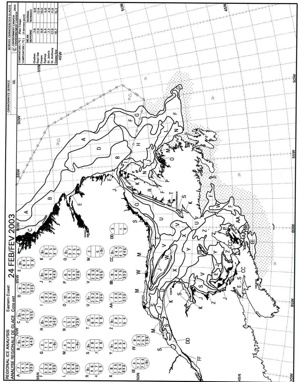
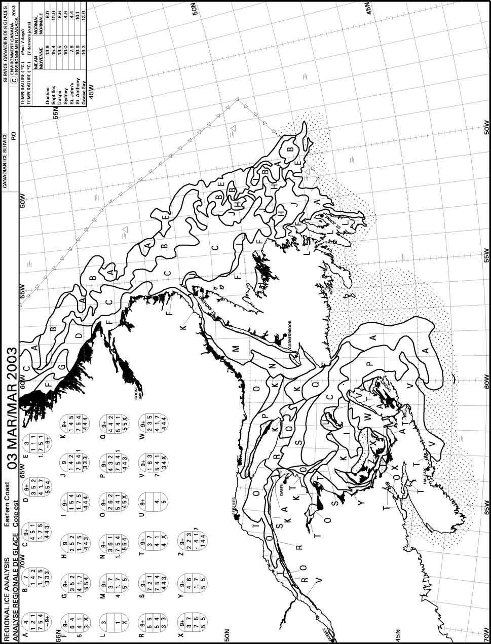
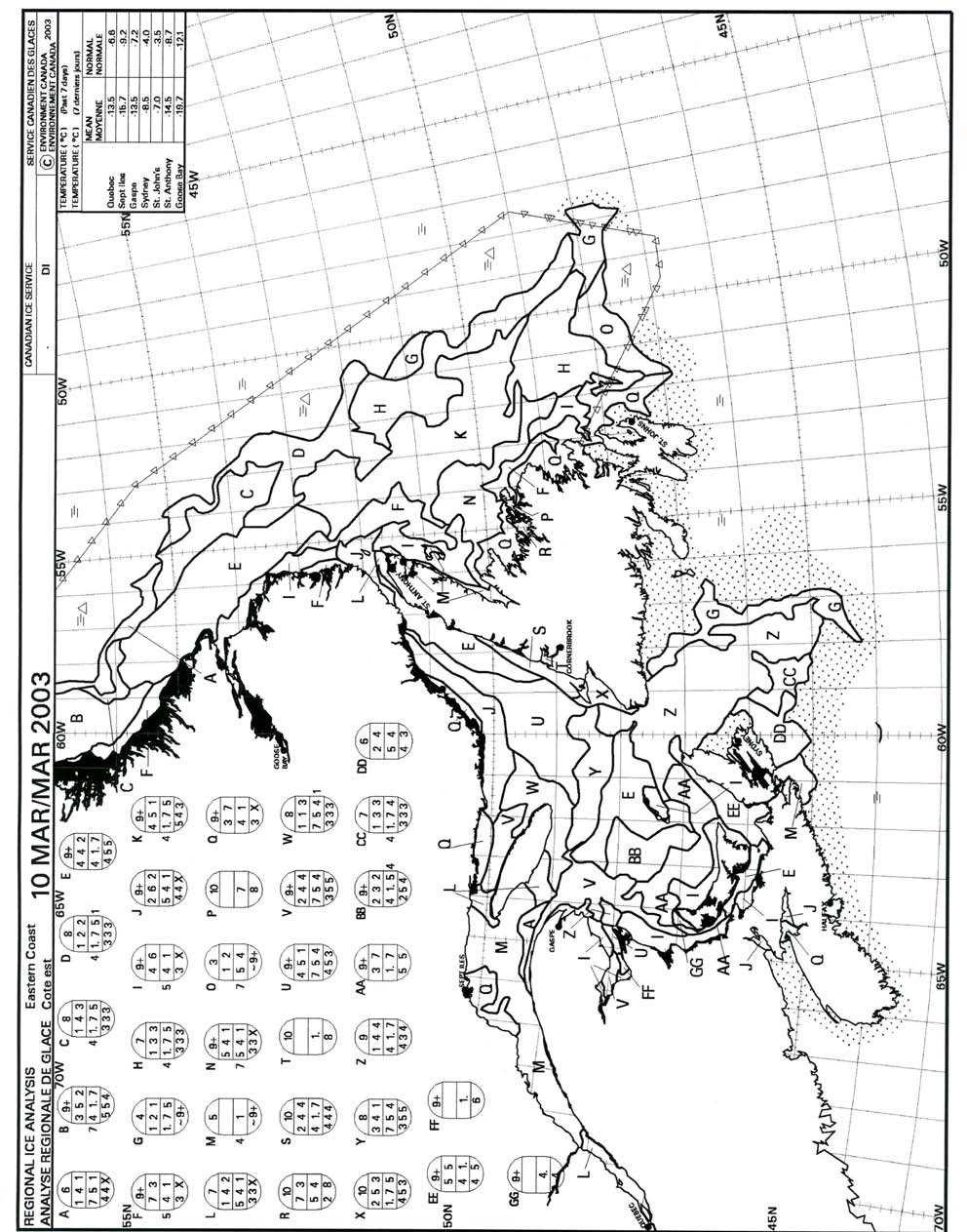
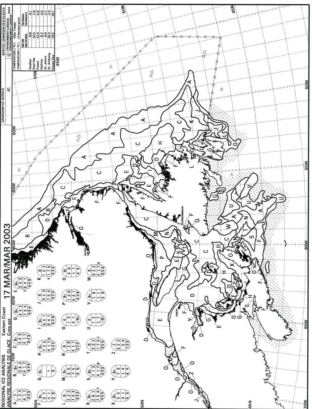
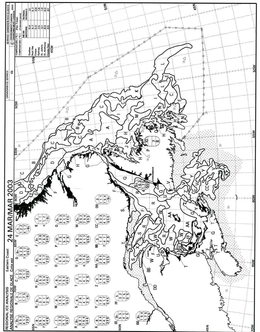
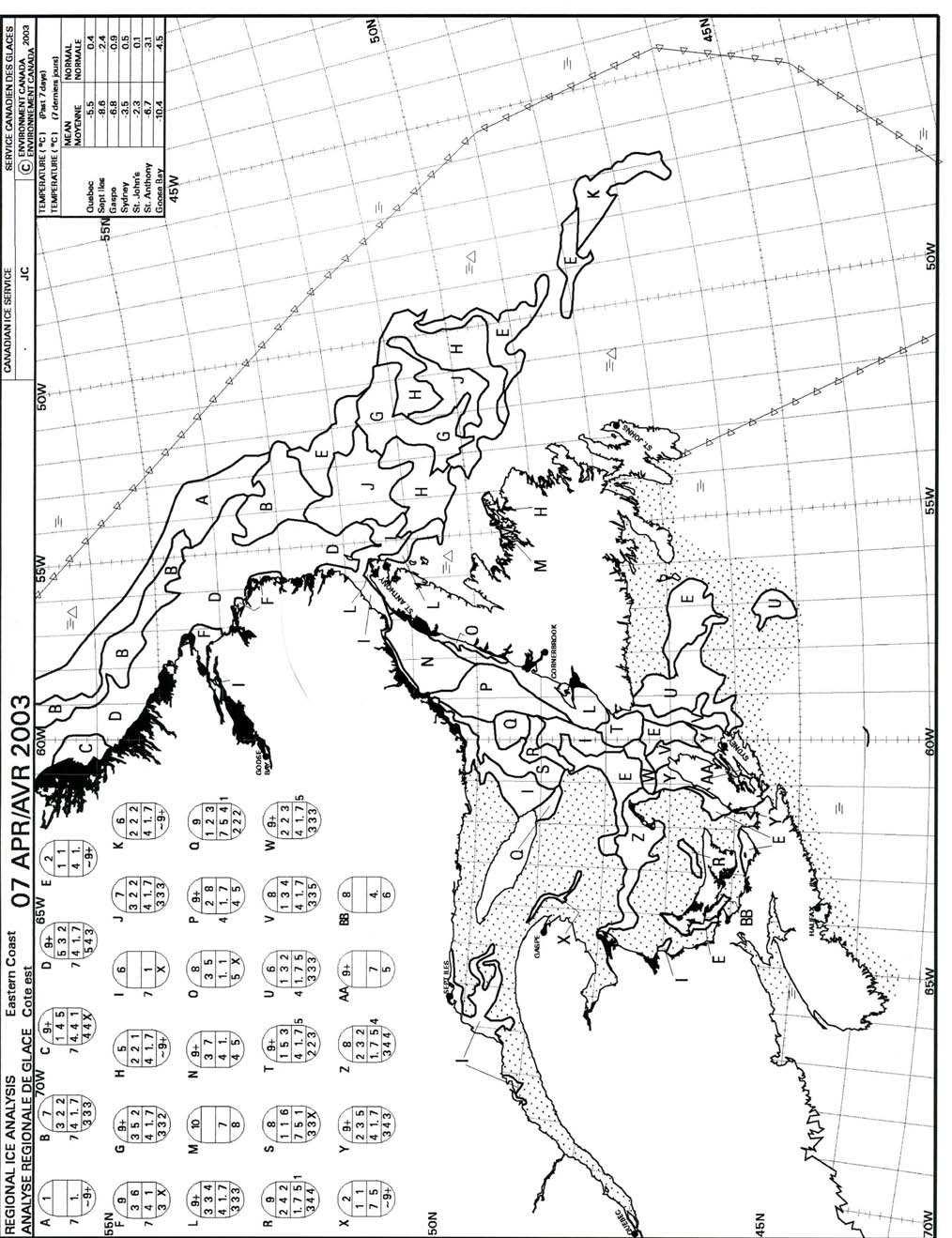
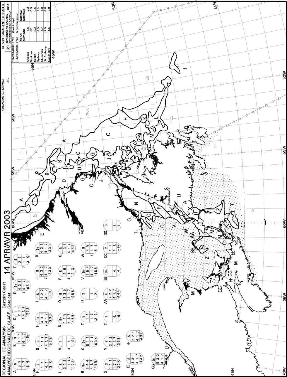
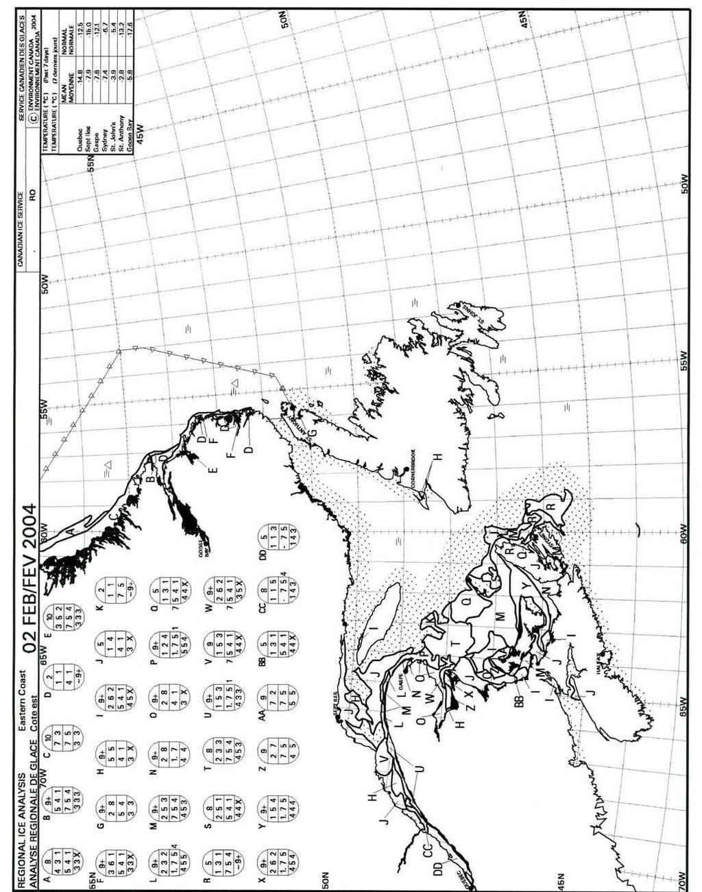
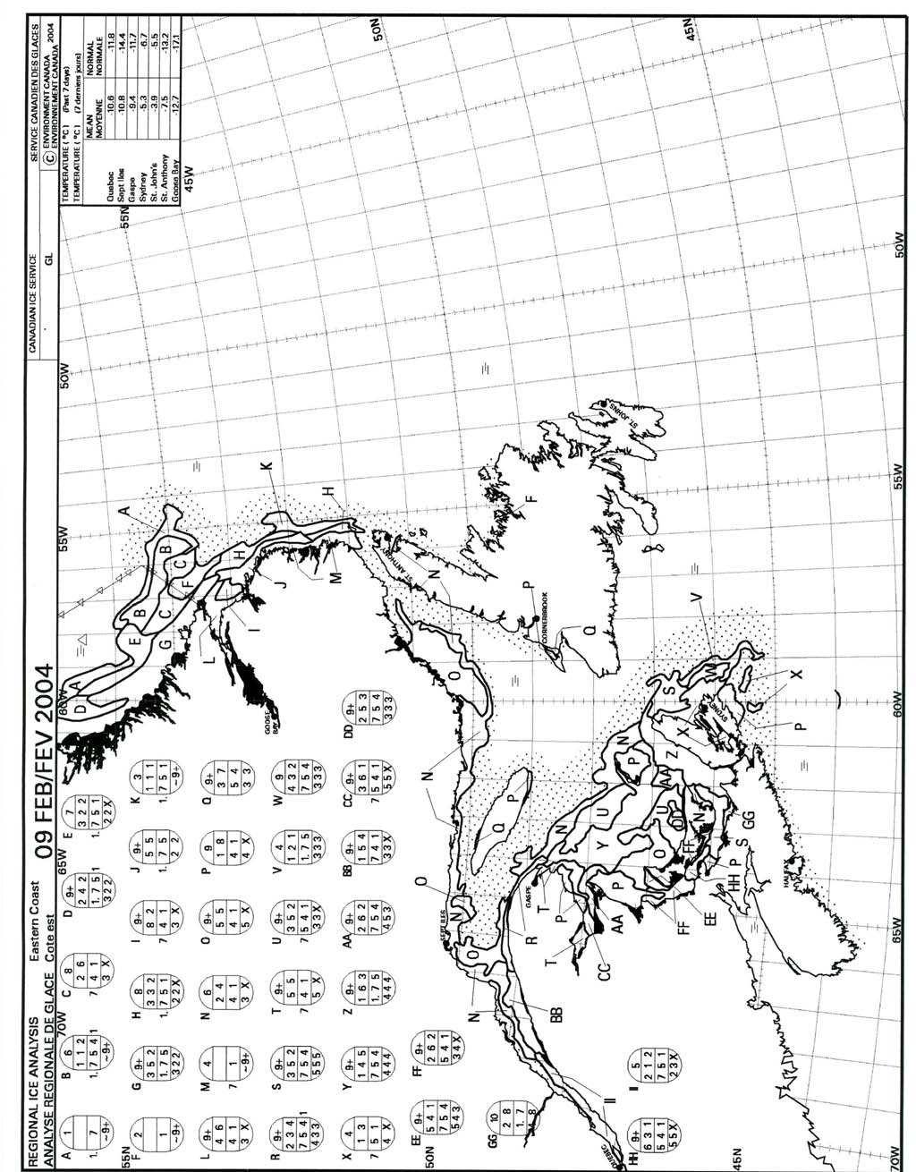
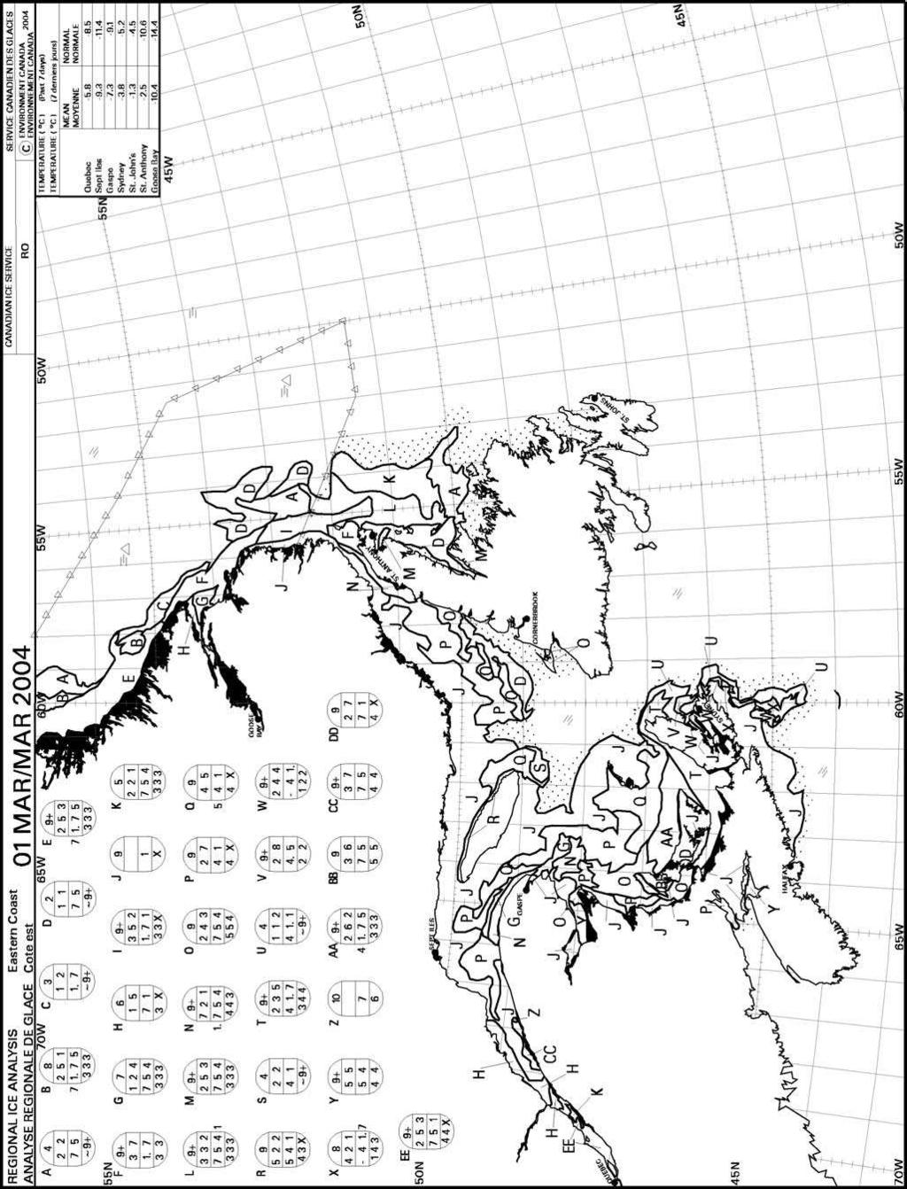
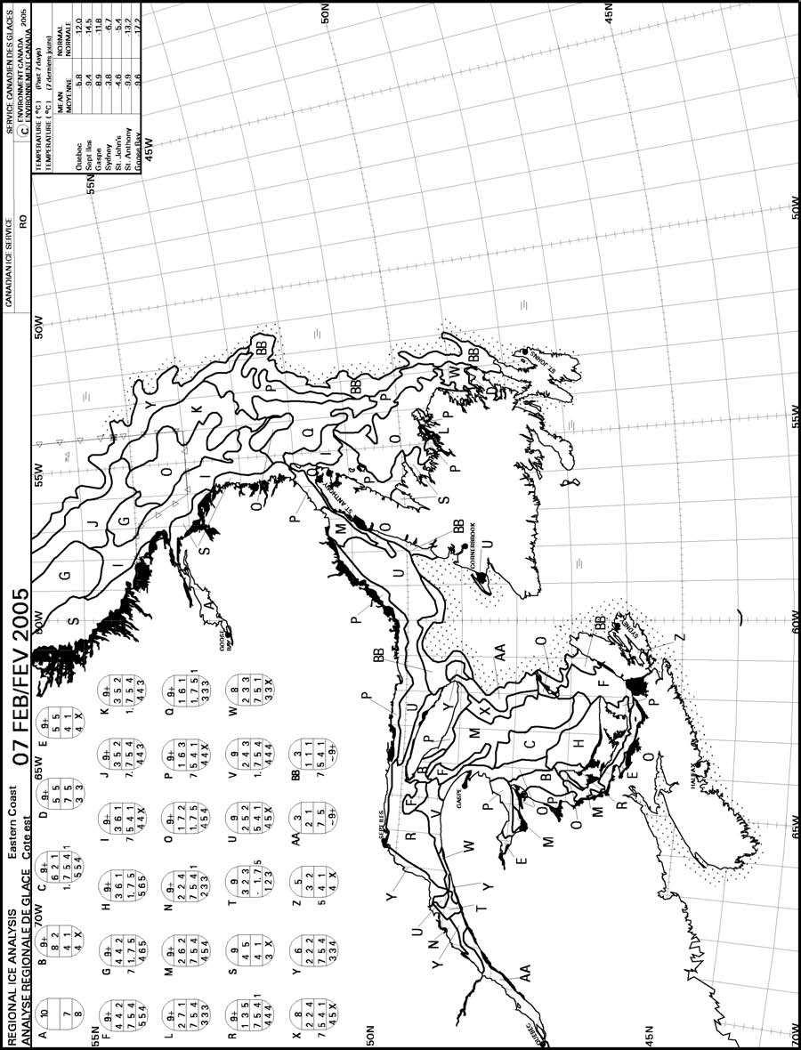
19 -9- II. Documenting Ice in the Bay of Fundy A. Data for (The Canadian Ice Service on line and Appendix One) Data from the Ice Archives of the Canadian Ice Service for the Bay of Fundy for the years are presented in Appendix One. In 2001 there were no reports of ice in the headwaters of the Bay of Fundy. During February, 2002, Cobequid Bay, Shepody Bay and the Cumberland Basin experienced greater than 90% ice cover with 30% of this ice cm thick in metre floes (see Appendix One). In 2003 Cobequid Bay, the Minas Passage, the Minas Channel, Cape Enrage, Shepody Bay and the Cumberland Basin (i.e., all the red items in Table One) experienced at least a 30% cover of 15 cm ice in floes at least 100 metres in the longest horizontal dimension. In 2004 the Minas Passage, Cobequid Bay and the Cumberland Basin experienced 30% cover of 15 cm thick ice in 100metre floes. In addition, at various times during 2003 and 2004, a 20% cover of ice at least 15 cm thick in 100 metre floes was present at all six of the sites in red in Table One (see Appendix One). In 2005, almost all sites listed in Table One (p. 6) experienced open water in February. open water is defined as less than 10% ice cover and is distinct from ice free (reference 19, p. I-9). We assume that the expression open water does not denote ice infestation sufficient to impact marine activities. Therefore, 2005 is not registered here as having a significant (see section II.,E.,1., p. 14 for definition of significance) ice infestation in the Bay of Fundy headwaters. In summary, examination of the data in the Ice Archives of the Canadian Ice Service indicates that in three of the last five years (2002, 2003 and 2004) significant (p. 14) ice has been reported in the head waters of the Bay of Fundy. The reader is directed to Appendix One for a more complete picture of the occurrence of sea ice in the headwaters of the Bay of Fundy between 2002 and 2005 (inclusive). B. Data from 1968 (Figures 1-5 (below), Appendix Two (this document) and reference 5)
20
21

22
23
24
25 -10- Figures One-Five are adapted from reference 5, Report to Atlantic Tidal Power Programming Board on Feasibility of Tidal Power Development in the Bay of Fundy. This study, funded by the Government of Canada, the Province of New Brunswick and the Province of Nova Scotia, documents in great detail the ice conditions in the Chignecto and Minas branches of the Bay of Fundy in the winter of Data collection was by both aerial surveillance and ground reconnaissance. The winter of 1968 was one of the coldest on record. Figure One shows the ice conditions in the upper Bay of Fundy on seven days in January, February and March of The diagrams indicate that ice over six inches (15 cm) thick covered 70% of Shepody Bay, Cape Enrage, the Cumberland Basin, the Minas Channel, the Minas Passage and Cobequid Bay during February and March. The most extensive ice cover occurred during the week of February 29, 1968, when Chignecto Bay, Minas Basin, Passage and Channel were 70 to 90% covered with medium and thick winter ice (Appendix Two, p. A3-4, this report), and may not be reflected on the diagram of that date in Figure One. (N.B. The expression Chignecto Bay subsumes Shepody Bay, Cape Enrage and the Cumberland Basin.) Figures Two thru Five show the EPRI harvest sites superimposed on ice maps of the headwaters of the Bay of Fundy on March 8, Figure Two shows the ice conditions in the Minas branch of the Bay of Fundy on March 8, The EPRI harvest sites (6) in the Cobequid Bay, the Minas Passage and the Minas Channel are superimposed on this ice map. Figures Four and Five are enlarged (and hopefully somewhat more readable) versions of this ice map for the Minas region and the Cobequid Bay. Figure Three is an ice map of the Chignecto branch of the Bay of Fundy on March 8, This figure has the EPRI harvest sites (7) superimposed in Shepody Bay, Cumberland Basin and Cape Enrage. By inspection of Figures One-Five, it is obvious that significant accumulations of ice were present at all the sites proposed by EPRI for tidal current energy harvest in the upper reaches of the Bay of Fundy during January, February and March of As noted above, these six sites three in the Minas Branch and three in the Chignecto Branch of the Bay of Fundy constitute over 90% of the energy EPRI feels is extractable from the Bay of Fundy in New Brunswick and Nova Scotia (Table One (p. 6) and references 6,7).
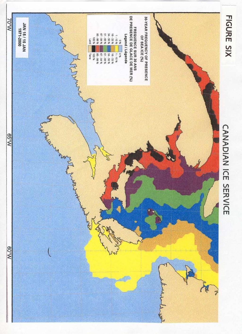
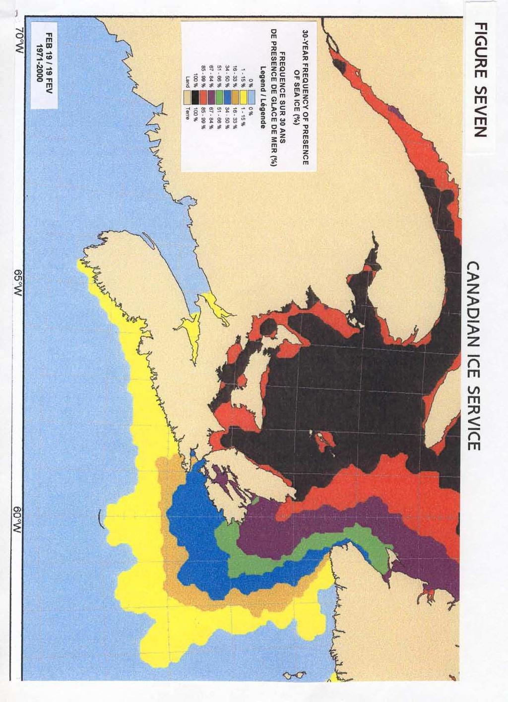
26 -11- By way of comparison with the data from the Canadian Ice Service for (discussed above section II., A., p. 9 this report), the accumulations of ice in 1968, as documented in the 1969 feasibility study, seem to exceed those of 2003 and This might be due to the exceptionally cold winter in 1968 or, perhaps, to the occurrence of global warming in the years since C. Data from (The Canadian Sea Ice Climate Atlas) The Canadian Ice Service did not consistently receive reports of ice in the Bay of Fundy between 1970 and 2000 (11). These incomplete reports were used to produce The Canadian Sea Ice Climate Atlas.+ Hence, this document is a minimal statement of ice in the Bay of Fundy for the period With the understanding that the following six charts from the Canadian Ice Atlas under-represent both the frequency and the extent of ice in the Bay of Fundy, the following interpretations of Figures Six thru Eleven are presented. + Erratum for Sea Ice Climate Atlas East Coast of Canada : Please note that ice in the Bay of Fundy area has not been reported consistently in the period Consequently, the atlas products are not reliable in that area (11).
27
28
29
30 -12- Figures 6, 7 and 8 suggest that sea ice has been present in both the Chignecto and Minas branches of the Bay of Fundy during January, February and March in 1-15% of the years between 1971 and The actual occurrence is likely higher than 15% over this period, since ice in the Bay of Fundy area was reported inconsistently to the Canadian Ice Service (p. 11, this report). As noted above (section II.A., p. 9, this report), sea ice occurred in the headwaters of the Bay of Fundy in three of the last five years.
31
32
33
34 -13- Figures 9, 10 and 11 provide information about the nature of the ice which occurred in the headwaters of the Bay of Fundy between 1971 and During January, February and March, the ice was either New Ice, Grey Ice or Grey-White Ice. According to Environment Canada s Fact Sheet on Sea Ice Symbols (see Appendix One, 1., this document), New Ice is less than 10 cm thick, Grey Ice is cm thick and Grey-White Ice is cm thick. Inspection of Figures 9-11 suggests that New Ice, Grey Ice or Grey White Ice were reported in the Cobequid Bay, the Minas Passage, Cape Enrage, Shepody Bay and the Cumberland Basin at some time during January, February or March in the period from 1971 to By way of comparison with the data in Figures 9-11, note that some of the ice in the Bay of Fundy headwaters during the winter of 1968 was thicker than 30 cm (12 inches). (See Figures One thru Five, this document, where ice thicker than 30 cm is called Thick Winter Ice. See also the discussion of the 1968 ice in Appendix Two, this document, pages A3-4 and A3-17, first complete paragraph.) As noted above (section II.,B., p. 11, this report), the winter of 1968 may have been exceptionally cold or there may now be a trend to less ice formation due to global warming. D. Impressions of an Eye Witness 1. Captain Lloyd McLellan (15) In December, 2005, Captain Lloyd McLellan retired as Captain of the Spanish Mist, a tug boat owned by Fundy Gypsum Company in Hantsport, Nova Scotia, after 37 years of service. Hantsport is located in the Minas Basin (see Satellite Image Two, p. 4), and cargo ships must pass through the Minas Channel and the Minas Passage to reach Fundy Gypsum s loading dock (see Satellite Image Two (p. 4), Photograph One (p. 5 ) and Table One (p. 6)). Fundy Gypsum ships rock from its facility in Hantsport and uses the Spanish Mist to assist cargo vessels as they traverse the Minas region of the Bay of Fundy to approach its dock. Cargo ships dock on the rising tide and sail at high tide. Approximately 40,000 tons of gypsum is loaded in less than three hours (16). Captain McLellan s report is that the approach of cargo ships to Fundy Gypsum s docking facility is obstructed by ice approximately one year in three. Some years cargo ships have had to wait two or more weeks for the ice to clear so they could reach the dock in Hantsport.
35 -14- However, in Captain McLellan s experience, the Minas Passage is only obstructed with ice for days not weeks---as is the case with the approach to Fundy Gypsum s dock in Hantsport. Under certain conditions, winds can blow ice into the Minas Passage, perhaps even overcoming the force of the incoming tide to temporarily obstruct this waterway. His feeling is that the strong tidal currents in the Minas Passage will often rapidly clear out the obstructing ice. The ice being cleared is sometimes moving pretty fast as it exits the Minas Passage. The velocity of ice movement has obvious implications for the design of tidal current devices (see below, section II.,E.,1.,b., p. 15 and section III.,D., p. 16). E. Findings 1. Significant sea ice occurs periodically in the tidal power-rich sites of the Bay of Fundy Both the records of the Canadian Ice Service (see Figures Six Eleven and Appendix One) and the ice survey done in 1968 by the Tidal Power Board (see Figures One Five and Appendix Two) suggest that significant sea ice has occurred in the head waters of the Bay of Fundy during some winters between 1967 and This conclusion is supported by the eyewitness report of Captain McLellan (section III.,D, above). Significant sea ice is defined [here as sea ice present in floes which are at least 15 cm thick and which are at least 100 metres in their longest surface dimension and which cover at least 30% of the total water surface. Ice floes of these dimensions would be likely to impact many marine activities, including the shipping of gypsum rock and the harvest of tidal energy. The precise frequency of significant sea ice in the Bay of Fundy headwaters from 1967 to 2005 remains uncertain. Consistent records of ice in the Bay of Fundy are only available for (11,12 and section II., A. and II., C. above) and for 1968 (reference 5, Figures One thru Five and Appendix One, this document). However, there is both systematic and anecdotal evidence that in three of the last five winters significant sea ice infestations occurred at some of the most promising sites for tidal power harvest in the headwaters of the Bay of Fundy. In one of the last five years, 2003, significant ice infestations occurred at all six of the most promising sites (Minas Passage, Minas Channel, Cape Enrage, Shepody Bay, Cumberland Basin, and Cobequid Bay see Table One) for tidal power harvest in the headwaters of the Bay of Fundy (see Appendix One), as it did in the winter of 1968 (see Figure One). And in 2004 three sites, Cobequid Bay, Minas Passage and Cumberland Basin met the criteria for significant sea ice infestation.
36 -15- In addition, 2002 experienced ice conditions at some sites (Shepody Bay, Cumberland Basin and Cobequid Bay) which would probably impact tidal current harvesting activities [i.e., 30% cover with 10 cm ice in 20 metre floes (see Appendix One)], although this infestation does not reach the definition of significance given on the preceding page. Moreover, it is conceivable that ice from the three sites infested in 2003 and the three sites infested in 2002 could impact tidal current energy harvest at the other tidal current sites in the Bay of Fundy headwaters, if the ice were to move to (or through) the other sites under the force of tidal currents or prevailing winds. a. Tidal power devices deployed at these sites would have to tolerate these ice conditions periodically As illustrated in Table One (p. 6), the headwaters of the Bay of Fundy contain some of the most promising sites to harvest tidal energy in North America. Any devices installed in these sites would minimally have to tolerate conditions similar to the 30% cover by 15 cm thick sea ice in 100 metre floes that occurred in To ensure longer operational life, tidal current devices should be capable of withstanding the thicker sea ice, the more extensive cover and the larger floes which occurred in 1968 (see figures One-Five and Appendix Two, pages A3-4 and A3-17). b. Tidal power devices deployed in the headwaters of the Bay of Fundy would also have to tolerate the movement of significant sea ice The velocity of sea ice movement would be an additional engineering consideration in the design and deployment of in-stream tidal current devices in the headwaters of the Bay of Fundy. The floes of ice in the Bay of Fundy are carried by tidal currents and driven by wind. When these forces worked in unison, ice velocities in excess of 8 knots might be attained. Tidal current devices for deployment in these sites should be designed to tolerate the presence of rapidly moving sea ice and/or the pressure of ice packed by winds and tidal currents. Additionally, circular tidal currents, particularly acting in highly energetic but spatially constricted regions such as the Minas Passage (Photograph One, p. 5; Table One, p. 6, line one), might cause sea ice floes to exert grinding forces on objects they contact, including components of tidal current harvesting devices. In summary, tidal current devices should be designed to tolerate the presence of rapidly moving sea ice and ice packed by wind and tidal currents, if they are to be deployed in the headwaters of the Bay of Fundy.
37 -16- III. Harvesting Tidal Current Energy in the Presence of Sea Ice. A. Introduction There are several obvious ways the presence of sea ice could impact the harvest of in-stream tidal energy. First, the presence of ice floes could alter the kinetic energy available for harvest by in-stream devices. Second, the presence of ice could reduce the weather windows for installation, maintenance, repair and overhaul of in-stream tidal current devices. Third, ice could make physical contact with the tidal current harvesting device. B. Impact of sea ice on the tidal current resource It is important to characterize the impact of ice floes on the tidal current resource in the headwaters of the Bay of Fundy. This characterization should begin with experiments to measure the tidal current resource as a function of depth i.e., from the water s surface to the sea floor in the absence of sea ice. This information would be particularly important in the Minas Passage, parts of which exceed 100 metres in depth (5,6). Similar depth-experiments can then be performed in the presence of ice. The impact of ice on the tidal current resource can be determined by comparing the size of the resource in the presence and absence of ice. C. Impact of sea ice on access to the tidal current resource The seasonal presence of sea ice will make the installation, repair, maintenance and overhaul of tidal current devices more challenging. Installation and routine maintenance could be scheduled during spring, summer and fall. Repairs during January, February and March might be minimized by the use of proven technology with high redundancy and low maintenance requirements. D. Physical contact between the harvesting device and sea ice The sea ice conditions at the most promising sites need to be characterized by further research. These sites would include, but perhaps not be restricted to, the Minas Passage and the Minas Channel in Nova Scotia and Cape Enrage in New Brunswick. Damage to tidal power harvesting devices, and/or their appendages, could occur from physical contact with sea ice. The extent of damage would depend on the design of the device and the momentum of the sea ice.
38 -17- It is important to note that both the mass and the velocity of sea ice must be determined. This report has emphasized the mass of ice present in the headwaters of the Bay of Fundy. However, as noted above, the tidal currents in the headwaters of the Bay of Fundy can exceed 7 knots (5,6,23) and produce non-linear flow patterns (Photograph One, p.5, and reference 5), which could grind sea ice against tidal energy devices. In addition, wind may affect both the velocity and direction of ice floes both during tidal ebb and flow and at slack tide. Research on the consequences of collisions of sea ice with tidal harvesting devices and/or their appendages would need to include studies of prevailing winter winds. Perhaps the most obvious method of avoiding physical contact between ice floes and in-stream tidal current harvesting devices would be to install the devices underwater, below the draught of sea ice (and any recreational or commercial vessels, if the tidal harvest area is also used for these purposes). Theoretically, such devices could either rest on the sea floor or be tethered at an appropriate depth below the sea surface. In either case, access to the device for servicing and maintenance will be increasingly restricted the further from the water s surface it is positioned. On the other hand, the further the device is from the water s surface, the less likely contact with sea ice will be. The inverse relationship between accessibility and protection has obvious design implications. For example, if accessibility is the paramount concern, in-stream tidal current devices which breech the water s surface would be a logical choice. However, in circumpolar climates, these devices will need to be engineered to tolerate ambient surface ice conditions. This type of arctic engineering project has succeeded both in Atlantic Canada and elsewhere in North America. The Confederation Bridge, which spans Northumberland Strait (see satellite Image Two, p. 4) between New Brunswick and Prince Edward Island, is an example of a structure engineered to tolerate more severe ice conditions than those in the headwaters of the Bay of Fundy in New Brunswick and Nova Scotia (see Figures One thru Eleven, Appendix Two (this document) and reference 8). The engineering principles developed for the Confederation Bridge could be applied to the design of ice-tolerant tidal current devices which breech the water s surface. Another example of successful arctic engineering is provided by the off shore oil and gas platforms in Cook Inlet, Alaska. These structures were designed to withstand the forces imposed by moving ice packs more formidable than those found in the Bay of Fundy, and The fact that there are now hundreds of platform-years of performance experience without a major failure testifies to the competence of the structural designs. (ref. 9, p. 17 [emphasis added]).
39 -18- On the other hand, if the major consideration is protection from contact with sea ice, this may be achieved by reducing device accessibility. However, location below the water s surface requires that tidal current devices be designed using proven technology and with adequate redundancy to obviate the need for service during periods of ice infestation (see section III., C., p. 16). It is quite possible that both surface (3,4) and submerged (18, 20,22) designs will find applications in harvesting tidal energy from ice-infested waters. For example, the physical characteristics of some micro-environments may favour installation of surface designs, while other microenvironments are better suited to the deployment of submerged devices.

40 -19- Satellite Image Three SOME NORTH AMERICAN TIDAL CURRENT SITES WITH SEA ICE Legend to Satellite Image Three A view of northern North America with some tidal current sites which experience seasonal sea ice. Modified from Google Earth (17).
41 -20- E. Conclusion Developing techniques to harvest tidal current power in the Bay of Fundy in the presence of sea ice could serve as a preliminary to the harvest of tidal current energy under more severe conditions of sea ice. Arctic engineering might eventually access the more challenging tidal currents in other jurisdictions such as Cook Inlet (Alaska) (9), Ungava Bay (Quebec) (10), the Straits of Belle Isle (Newfoundland and Labrador), the Gulf of St. Lawrence (Quebec) and Northumberland Strait (Prince Edward Island/New Brunswick) (8) (see Satellite Image Three, p. 19). Beyond the North American Continent, other circumpolar jurisdictions with energetic tidal flows may also become markets for ice-tolerant tidal current harvesting technology. In these jurisdictions it is possible that tidal power can replace the energy now obtained from non-renewable resources such as oil and gas. IV. References 1. Wavegen 2. Ocean Power Delivery 3. Verdant Power 4. Marine Current Turbines 5. Report to Atlantic Tidal Power Programming Board on Feasibility of Tidal Power Development in the Bay of Fundy: Appendix 3 Ice and Sediment by Atlantic tidal Power Engineering and Management Committee, Halifax, Nova Scotia, Canada, October, EPRI Nova Scotia Tidal In-Stream Energy Conversion (TISEC): Survey and Characterization of Potential Project Sites, by George Hagerman, Gordon Fader, Greg Carlin and Roger Bedard. Draft EPRI TP- 003 NS Rev 1, Dec. 30, Downloaded January 3, 2006 from
42 EPRI New Brunswick Tidal In-Stream Energy Conversion (TISEC): Survey and Characterization of Potential Project Sties, by George Hagerman, Gordon Fader and Roger Bedard. EPRI TP- 003 NB, Oct. 31, Downloaded December 4, 2005, from [Report not on this site, March 19, 2006, 1:30PM AST] 8. Building the Bridge to P.E.I. by Harry Thruston, Nimbus Publishing Limited, Halifax, Nova Scotia, Marine Ice Atlas for Cook Inlet, Alaska prepared by the U.S. Army Corps of Engineers, Engineer Research and Development Center, Cold Regions Research and Engineering Laboratory, May, The Tidal Power Potential of Ungava Bay and its possible Exploitation in Conjunction with the Local Hydroelectric Resources by G. Godin. Manuscript Report Series No. 30, Marine Sciences Directorate, Department of Environment, Ottawa, The Canadian Ice Service s Sea Ice Climate Atlas East Coast of Canada Canadian Ice Service Archive, Regional Ice Analysis Charts. Go to site in reference 11. and click on Ice Archives. 13. Nova Scotia Power, About Us, The Power to Produce. Downloaded March 12, Tidal Life: A Natural History of the Bay of Fundy, by Harry Thruston with photographs by Stephen Homer, Nimbus Publishing, Halifax, Nova Scotia, Canada, 1990, pp Captain Lloyd McLellan, personal communication to Richard Sanders, March 6, Fundy Gypsum Company psum 17. Google Earth
43 Lunar Energy Canadian Ice Service MANICE: Manual of Standard Procedures for Observing and Reporting Ice Conditions. ISBN ; Catalogue No. En , Ninth Edition, April Blue Energy EPRI Guidelines: Guidelines for Preliminary Estimation of Power Production by Tidal In Stream (Current) Energy Conversion Devices. EPRI-TP-001NA by George Hagerman et al. August 26, Downloaded January, 2006, from Clean Current See reference 14, p. 20; Industrial Canada, August, 1918; and the Esther Clark Wright Archives of the Vaughan Memorial Library, Acadia University, Wolfville, Nova Scotia, Canada, folio / See Dominion of Canada Patent Number , dated October 10, 1916, folio /3, the Esther Clark Wright Archives of the Vaughan Memorial Library, Acadia University, Wolfville, Nova Scotia, Canada. V. Appendices A. Appendix One 1. Environment Canada Fact Sheet: Sea Ice Symbols 2. Canadian Ice Service Regional Ice Analyses: Eastern Coast a. Selected data
44
45
46
47
48
49
50
51
52
53
54
55
56
57
58
59
60
61
62
63 B. Appendix Two 1. Report to Atlantic Tidal Power Programming Board on Feasibility of Tidal Power Development in the Bay of Fundy: Appendix 3 Ice and Sediment by Atlantic tidal Power Engineering and Management Committee, Halifax, Nova Scotia, Canada, October, 1969, pages 1-17.
64
65
66
67
68
69
70
71
72
73
74
75
76
77
78
79
80
81
Appendix 12: Marine Transportation Study. (Gartner Lee Ltd. 2008)
") Appendix 12: Marine Transportation Study (Gartner Lee Ltd. 2008) memorandum to: John Woods, Minas Basin Pulp and Power Co. Ltd from: Joseph Kozak date: ref: GLL 80308 re: FINAL Technical Marine Transportation
Appendix 12: Marine Transportation Study (Gartner Lee Ltd. 2008) memorandum to: John Woods, Minas Basin Pulp and Power Co. Ltd from: Joseph Kozak date: ref: GLL 80308 re: FINAL Technical Marine Transportation
Tidal Energy. Definition of Tidal Energy. Tidal energy is energy derived from the movement of the ocean tides.
 Tidal Energy Definition of Tidal Energy Tidal energy is energy derived from the movement of the ocean tides. Water has mass. When it moves, it has kinetic energy which can be harnessed. Kinetic energy
Atlantic Pilotage Authority
 Atlantic Pilotage Authority Presentation to Whites Point Rock Quarry Project, Digby, NS. Digby, N.S. June 20, 2007 Captain Patrick Gates Director of Operations Atlantic Pilotage Authority Mandate To establish,
Modelling and Assessment of Marine Renewable Energy Resources. Andrew Cornett Canadian Hydraulics Centre National Research Council Canada May 2008
 Modelling and Assessment of Marine Renewable Energy Resources Andrew Cornett Canadian Hydraulics Centre National Research Council Canada May 2008 Background Pan-Canadian resource inventory in 2005/06 Canada
La Rance tidal power plant in La Rance, France. Tidal and Wave Energy
 La Rance tidal power plant in La Rance, France Tidal and Wave Energy Tides Tides are caused by the pull of the moon. Tides involve the rise and fall of sea levels. Around the coast of Ireland, the sea
GUIDELINES FOR NAVIGATION UNDER THE CONFEDERATION BRIDGE
 (12/2009) GUIDELINES FOR NAVIGATION UNDER THE CONFEDERATION BRIDGE REVISION 1 DECEMBER 2009 Responsible Authority The Regional Director Marine Safety Atlantic Region is responsible for this document, including
HARBOUR SEDIMENTATION - COMPARISON WITH MODEL
 HARBOUR SEDIMENTATION - COMPARISON WITH MODEL ABSTRACT A mobile-bed model study of Pointe Sapin Harbour, in the Gulf of St. Lawrence, resulted in construction of a detached breakwater and sand trap to
Chapter 11 Tides. A tidal bore is formed when a tide arrives to an enclosed river mouth. This is a forced wave that breaks.
 Chapter 11 Tides A tidal bore is formed when a tide arrives to an enclosed river mouth. This is a forced wave that breaks. Tidal range can be very large Tide - rhythmic oscillation of the ocean surface
Southern Gulf of St. Lawrence Sea Scallop
 DFO Science Stock Status Report C3-16 (1998) 21 22 23 24 Southern Gulf of St. Lawrence Sea Scallop Background The sea scallop (Placopecten magellanicus), is a bivalve mollusc found only in the north-western
APPENDIX G WEATHER DATA SELECTED EXTRACTS FROM ENVIRONMENTAL DATA FOR BCFS VESSEL REPLACEMENT PROGRAM DRAFT REPORT
 APPENDIX G WEATHER DATA SELECTED EXTRACTS FROM ENVIRONMENTAL DATA FOR BCFS VESSEL REPLACEMENT PROGRAM DRAFT REPORT Prepared for: B.C. Ferries Services Inc. Prepared by: George Roddan, P.Eng. Roddan Engineering
Discussion on the Selection of the Recommended Fish Passage Design Discharge
 Discussion on the Selection of the Recommended Fish Passage Design Discharge Introduction The provision of fish passage is a requirement for most proposed culvert and bridge installations in Alberta, depending
Whitney Hauslein Global War Wa ming
 Whitney Hauslein Global Warming The Ocean has only recently been used and tested as a new resource to be used as an alternative energy source. This seems awful late in forthcoming since the ocean covers
The Impact on Great South Bay of the Breach at Old Inlet Charles N. Flagg School of Marine and Atmospheric Sciences, Stony Brook University
 The Impact on Great South Bay of the Breach at Old Inlet Charles N. Flagg School of Marine and Atmospheric Sciences, Stony Brook University The previous report provided a detailed look at the conditions
COUNTRIES THAT CONTRAVENE SCIENTIFIC ADVICE BY HARVESTING MIXED-POPULATIONS OF NORTH AMERICAN SALMON
 SCIENTIFIC ADVICE A Backgrounder from Atlantic Salmon Federation P. O. Box 5200, St. Andrews, NB E5B 3S8 P. O. Box 807, Calais, ME USA 04619 0807 Tel: (506) 529 4581 www.asf.ca State of North American
TICES TO MARINERS 1 TO 46 ANNUAL EDITION 2018 SECTION A AIDS TO NAVIGATION AND MARINE SAFETY
 A5 NAVIGATION SAFETY 10 Routeing of Ships 1 GENERAL 1.1 Rule 10 of the Collision Regulations applies to all ships navigating in or near a routeing system. 1.2 The information on ships' routeing in this
Sensor Platform Project Marine Trials Bidders Conference. Fundy Ocean Research Center for Energy fundyforce.ca
 Sensor Platform Project Marine Trials Bidders Conference Fundy Ocean Research Center for Energy fundyforce.ca 1 Project Team FORCE OceanWorks International Preliminary Design, Operational Procedures Murray
COUNTRIES THAT CONTRAVENED SCIENTIFIC ADVICE BY HARVESTING MIXED POPULATIONS OF NORTH AMERICAN SALMON IN 2017
 SCIENTIFIC ADVICE The International Council for the Exploration of the Sea (ICES) advises: There is no surplus of multi-sea-winter salmon for a fishery at West Greenland for 2018, 2019, and 2020. ICES
Marine Renewables Industry Association. Marine Renewables Industry: Requirements for Oceanographic Measurements, Data Processing and Modelling
 Marine Renewables Industry Association Marine Renewables Industry: Requirements for Oceanographic Measurements, Data Processing and Modelling October 2009 Table of Contents 1. Introduction... 1 2. Measurements
170 points. 38 points In your textbook, read about modern oceanography. For each item write the word that meets the description.
 Ch 15 Earth s Oceans SECTION 15.1 An Overview of Oceans 38 points In your textbook, read about modern oceanography. For each item write the word that meets the description. (5 points) 1. German research
Lecture Outlines PowerPoint. Chapter 15 Earth Science, 12e Tarbuck/Lutgens
 Lecture Outlines PowerPoint Chapter 15 Earth Science, 12e Tarbuck/Lutgens 2009 Pearson Prentice Hall This work is protected by United States copyright laws and is provided solely for the use of instructors
ASSESSMENT OF THE WEST COAST OF NEWFOUNDLAND (DIVISION 4R) HERRING STOCKS IN 2011
 HERRING STOCKS IN 2011") Canadian Science Advisory Secretariat Science Advisory Report 212/24 ASSESSMENT OF THE WEST COAST OF NEWFOUNDLAND (DIVISION 4R) HERRING STOCKS IN 211 Context Figure 1. Map of unit areas of NAFO Division
Canadian Science Advisory Secretariat Science Advisory Report 212/24 ASSESSMENT OF THE WEST COAST OF NEWFOUNDLAND (DIVISION 4R) HERRING STOCKS IN 211 Context Figure 1. Map of unit areas of NAFO Division
Version 1.0 ICE CHART COLOUR CODE STANDARD. WMO/TD-No Originally Published 2004 Version 1 May JCOMM Technical Report No.
 WORLD METEOROLOGICAL ORGANIZATION INTERGOVERNMENTAL OCEANOGRAPHIC COMMISSION (OF UNESCO) ICE CHART COLOUR CODE STANDARD Version 1.0 WMO/TD-No. 1215 Originally Published 2004 Version 1 May 2014 JCOMM Technical
13. TIDES Tidal waters
 Water levels vary in tidal and non-tidal waters: sailors should be aware that the depths shown on the charts do not always represent the actual amount of water under the boat. 13.1 Tidal waters In tidal
Admiralty Inlet Pilot Tidal Project FERC No Appendix C. Derelict Gear Monitoring Plan
 Appendix C Derelict Gear Monitoring Plan ADMIRALTY INLET PILOT TIDAL PROJECT FERC PROJECT NO. 12690 DERELICT GEAR MONITORING PLAN (submitted with the Final Application for a New Pilot Project License)
Wave Energy Atlas in Vietnam
 Wave Energy Atlas in Vietnam Nguyen Manh Hung, Duong Cong Dien 1 1 Institute of Mechanics, 264 Doi Can Str. Hanoi, Vietnam nmhungim@gmail.com; duongdienim@gmail.com Abstract Vietnam has achieved remarkable
Gulf of Maine Research Institute Responsibly Harvested Seafood from the Gulf of Maine Region Report on Atlantic Sea Scallops (Inshore Canada)
") Gulf of Maine Research Institute Responsibly Harvested Seafood from the Gulf of Maine Region Report on Atlantic Sea Scallops (Inshore Canada) The fishery is managed by a competent authority and has a management
Gulf of Maine Research Institute Responsibly Harvested Seafood from the Gulf of Maine Region Report on Atlantic Sea Scallops (Inshore Canada) The fishery is managed by a competent authority and has a management
Appendix 5: Currents in Minas Basin. (Oceans Ltd. 2009)
") Appendix 5: Currents in Minas Basin (Oceans Ltd. 29) Current in Minas Basin May 1, 28 March 29, 29 Submitted To: Minas Basin Pulp and Power P.O. Box 41 53 Prince Street Hansport, NS, BP 1P by 22, Purdy
Appendix 5: Currents in Minas Basin (Oceans Ltd. 29) Current in Minas Basin May 1, 28 March 29, 29 Submitted To: Minas Basin Pulp and Power P.O. Box 41 53 Prince Street Hansport, NS, BP 1P by 22, Purdy
The ocean water is dynamic. Its physical
 CHAPTER MOVEMENTS OF OCEAN WATER The ocean water is dynamic. Its physical characteristics like temperature, salinity, density and the external forces like of the sun, moon and the winds influence the movement
Southern Gulf of St. Lawrence (4T) Herring
 Herring") Stock Status Report 24/23 Southern Gulf of St. Lawrence (4T) Herring Background Herring are a pelagic species which form schools during feeding and spawning periods. Herring in the southern Gulf of St.
Stock Status Report 24/23 Southern Gulf of St. Lawrence (4T) Herring Background Herring are a pelagic species which form schools during feeding and spawning periods. Herring in the southern Gulf of St.
Synthesis of Practices of Geometric Design for Special Roads
 Transportation Association of Canada Primer Synthesis of Practices of Geometric Design for Special Roads Introduction Special roads is a category for roads that tends not to fit into the standard definition
OFFICE OF STRUCTURES MANUAL FOR HYDROLOGIC AND HYDRAULIC DESIGN CHAPTER 11 APPENDIX B TIDEROUT 2 USERS MANUAL
 OFFICE OF STRUCTURES MANUAL FOR HYDROLOGIC AND HYDRAULIC DESIGN CHAPTER 11 APPENDIX B TIDEROUT 2 USERS MANUAL APRIL 2011 APRIL 2011 Page 1 Preface TIDEROUT 2, Build 1.22 dated June 29, 2006 is the current
THE CHALLENGES OF A LARGE-AREA BATHYMETRIC SURVEY
 THE CHALLENGES OF A LARGE-AREA BATHYMETRIC SURVEY Agenda: - Introduction - Tender - Project Planning - Survey - Processing - Delivery - Conclusion 2 Introduction We know less of the oceans at our feet,
Crash Patterns in Western Australia. Kidd B., Main Roads Western Australia Willett P., Traffic Research Services
 Crash Patterns in Western Australia Kidd B., Main Roads Western Australia Willett P., Traffic Research Services Abstract Examination of crash patterns is one way of identifying key factors on which focus
DUNE STABILIZATION AND BEACH EROSION
 DUNE STABILIZATION AND BEACH EROSION CAPE HATTERAS NATIONAL SEASHORE NORTH CAROLINA ROBERT DOLAN PAUL GODFREY U. S. DEPARTMENT OF INTERIOR NATIONAL PARK SERVICE OFFICE OF NATURAL SCIENCE WASHINGTON, D.
NOTICES TO MARINERS 1 to 46 ANNUAL EDITION 2018
 NOTICES TO MARINERS 1 to 46 CANADIAN COAST GUARD www.notmar.gc.ca Notices to Mariners 1 to 46 Annual Edition 2018 Published under the authority of: Canadian Coast Guard Programs Aids to Navigation and
Management of American Eel Fisheries in Canada. Laura Hussey-Bondt Senior Advisor, Resource Management Fisheries and Oceans Canada Maritimes Region
 Management of American Eel Fisheries in Canada Laura Hussey-Bondt Senior Advisor, Resource Management Fisheries and Oceans Canada Maritimes Region DFO Regions 2 Overview: Management of American Eel Fisheries
Ocean Energy. Haley, Shane, Alston
 Ocean Energy Haley, Shane, Alston What is Ocean Energy? The world s oceans cover nearly 70% of the world's surface The oceans are the world's largest collector of the sun s energy that is continually
OPERATIONS SEAFARER CERTIFICATION GUIDANCE NOTE SA MARITIME QUALIFICATIONS CODE. Deck: Chart Work
 Page 1 of 6 Compiled by Approved by Chief Examiner Syllabus Committee: 26 February 2013 OPERATIONS SEAFARER CERTIFICATION GUIDANCE NOTE SA MARITIME QUALIFICATIONS CODE Deck: Chart Work Page 2 of 6 COLUMN
WATERWAYS AND HARBORS DIVISION Proceedings of the American Society of Civil Engineers. EQUILIBRIUM FLOW AREAS OF INLETS ON SANDY COASTS a
 6405 February, 1969 WWl J oumal of the WATERWAYS AND HARBORS DIVISION Proceedings of the American Society of Civil Engineers EQUILIBRIUM FLOW AREAS OF INLETS ON SANDY COASTS a By Morrough P. O'Brien,!
Removal of natural obstructions to improve Atlantic Salmon and Brook Trout habitat in western NL. 26/02/2015 Version 2.0
 Removal of natural obstructions to improve Atlantic Salmon and Brook Trout habitat in western NL 26/02/2015 Version 2.0 1 Table of Contents List of Tables... 2 Introduction... 3 Methods... 4 Preliminary
Map Showing NAFO Management Units
 Map Showing NAFO Management Units Biology Are 6 species of seals in Atlantic Canadian waters, all of which occur in Newfoundland Two Arctic Species (Ringed, Bearded) Two temperate (Grey, Harbour) Two migratory
+)) Lower Churchill Project RIPRAP DESIGN FOR WIND-GENERATED WAVES SNC LAVALIN. SLI Document No HER
) Lower Churchill Project RIPRAP DESIGN FOR WIND-GENERATED WAVES SNC LAVALIN. SLI Document No HER") +)) SNC LAVALIN Lower Churchill Project RIPRAP DESIGN FOR SLI Document No. 505573-3001-4HER-0011-00 Nalcor Reference No. MFA-SN-CD-0000-CV-RP-0006-01 Rev. 81 Date: 07 -Dec-2012 Prepared by: Checked by:
+)) SNC LAVALIN Lower Churchill Project RIPRAP DESIGN FOR SLI Document No. 505573-3001-4HER-0011-00 Nalcor Reference No. MFA-SN-CD-0000-CV-RP-0006-01 Rev. 81 Date: 07 -Dec-2012 Prepared by: Checked by:
Bay of Fundy Estuary Profile
 s The is a sub-basin of the Bay of Fundy along the northwestern shore of Nova Scotia and at the western end of the Annapolis Valley. The Annapolis River is the major water source flowing into the estuary.
Tidal energy is produced by the surge of ocean waters during the rise and fall of tides. Tidal energy is a renewable source of energy.
 Encyclopedic Entry For Educator tidal energy For the complete encyclopedic entry with media resources, visit: http://www.connectenergyed.org/education/encyclopedia/tidal-energy/ Tidal energy is produced
Recent developments in wave energy along the coast of southern Africa
 Recent developments in wave energy along the coast of southern Africa J. R. Joubert 1 and J. L. van Niekerk 2 1 Centre for Renewable Energy Studies, Mechanical & Mechatronic Engineering Department, Stellenbosch
Figure 1, Chart showing the location of the Breach at Old Inlet and sensors deployed in Great South Bay.
 The Impact on Great South Bay of the Breach at Old Inlet Charles N. Flagg and Roger Flood School of Marine and Atmospheric Sciences, Stony Brook University The Great South Bay project (http://po.msrc.sunysb.edu/gsb/)
Southern Gulf of St. Lawrence (4T) Herring
 Herring") Fisheries Pêches and Oceans et Océans DFO Science Stock Status B3-1 (22) Southern Gulf of St. Lawrence (4T) Herring Background Herring are a pelagic species which form schools during feeding and spawning
Fisheries Pêches and Oceans et Océans DFO Science Stock Status B3-1 (22) Southern Gulf of St. Lawrence (4T) Herring Background Herring are a pelagic species which form schools during feeding and spawning
Operating Principle, Performance and Applications of the Wave Mill
 Journal of Energy and Power Engineering 11 (2017) 311-316 doi: 10.17265/1934-8975/2017.05.004 D DAVID PUBLISHING Operating Principle, Performance and Applications of the Wave Mill Ivan Voropaev Wave Power
Energy from seas and oceans
 Energy from seas and oceans Marine energy can represent an important source of renewable energy in the near future. In Italy, activities performed in this sector are growing rapidly both in terms of assessment
A real time vessel air gap monitoring system
 Journal of Physics: Conference Series A real time vessel air gap monitoring system To cite this article: D McStay and K Thabeth 2009 J. Phys.: Conf. Ser. 178 012038 View the article online for updates
Press Release 2005/8/24
 Canadian Council of Professional Fish Harvesters Conseil Canadien des Pêcheurs Professionnels 102 Bank, Suite 202, Ottawa, Ontario K1P 5N4 CANADA Tel: (613) 235-3474 Fax: (613) 231-4313 E-mail/Courriel:
HYDROSPHERE, OCEANS AND TIDES
 HYDROSPHERE, OCEANS AND TIDES Revision 10x10learning.com 1 Chapter 12. In the Earth s Atmosphere On surface of the Earth Under the ground Hydrosphere comprises of ALL WATER Water Vapour = 0.001% Is very
Year Avg. TAC Can Others Totals
 SKATE IN DIVISIONS 3L, 3N, 3O AND SUBDIVISION 3Ps Background There are 8 to 1 species of skate in the waters around Newfoundland. Of these, thorny skate (Raja radiata) is by far the most common, comprising
Chapter 10 Lecture Outline. The Restless Oceans
 Chapter 10 Lecture Outline The Restless Oceans Focus Question 10.1 How does the Coriolis effect influence ocean currents? The Ocean s Surface Circulation Ocean currents Masses of water that flow from one
Adapting and Developing Hands Free Mooring for Navigation Locks Speaker: Benoit Nolet
 Adapting and Developing Hands Free Mooring for Navigation Locks Speaker: Benoit Nolet The Great Lakes St. Lawrence Seaway System A gateway to the heartland of North America 3,700 km (2,300 m) marine highway
Chapter 4 EM THE COASTAL ENGINEERING MANUAL (Part I) 1 August 2008 (Change 2) Table of Contents. Page. I-4-1. Background...
 1 August 2008 (Change 2) Table of Contents. Page. I-4-1. Background...") Chapter 4 EM 1110-2-1100 THE COASTAL ENGINEERING MANUAL (Part I) 1 August 2008 (Change 2) Table of Contents I-4-1. Background... Page I-4-1 a. Shore Protection Planning and Design, TR 4... I-4-1 b. Shore
Chapter 4 EM 1110-2-1100 THE COASTAL ENGINEERING MANUAL (Part I) 1 August 2008 (Change 2) Table of Contents I-4-1. Background... Page I-4-1 a. Shore Protection Planning and Design, TR 4... I-4-1 b. Shore
Hydrographic Surveying Methods, Applications and Uses
 Definition: Hydrographic Surveying Methods, Applications and Uses It is the branch of surveying which deals with any body of still or running water such as a lake, harbor, stream or river. Hydrographic
Inlet Management Study for Pass-A-Grille and Bunces Pass, Pinellas County, Florida
 Inlet Management Study for Pass-A-Grille and Bunces Pass, Pinellas County, Florida Final Report Submitted By Ping Wang, Ph.D., Jun Cheng Ph.D., Zachary Westfall, and Mathieu Vallee Coastal Research Laboratory
GUIDE TO THE ARCTIC SHIPPING CALCULATION TOOL
 ØRTS HANSEN, GRØNSEDT, LINDSTRØM GRAVERSEN AND HENDRIKSEN GUIDE TO THE ARCTIC SHIPPING CALCULATION TOOL THE NORTHERN SEA ROUTE VS. THE SUEZ CANAL ROUTE CBS MARITIME CROSS DISCIPLINARY PROBLEM-FOCUSED RESEARCH
Energy capture performance
 Energy capture performance Cost of energy is a critical factor to the success of marine renewables, in order for marine renewables to compete with other forms of renewable and fossil-fuelled power generation.
The Challenge of Wave Scouring Design for the Confederation Bridge
 13: Coastal and Ocean Engineering ENGI.8751 Undergraduate Student Forum Faculty of Engineering and Applied Science, Memorial University, St. John s, NL, Canada MARCH 2013 Paper Code. (13 - walsh) The Challenge
INTERNATIONAL HYDROGRAPHIC SURVEY STANDARDS
 INTERNATIONAL HYDROGRAPHIC SURVEY STANDARDS by Gerald B. MILLS 1 I. Background The International Hydrographic Organization (IHO) traces its origin to the establishment of the International Hydrographic
Chapter 22, Section 1 - Ocean Currents. Section Objectives
 Chapter 22, Section 1 - Ocean Currents Section Objectives Intro Surface Currents Factors Affecting Ocean Currents Global Wind Belts (you should draw and label a diagram of the global wind belts) The Coriolis
Glenn Avenue Corridor Traffic Operational Evaluation
 Glenn Avenue Corridor Traffic Operational Evaluation PREPARED FOR: THE CITY OF AUBURN PREPARED BY: DECEMBER 2007 Glenn Avenue Corridor Study--Auburn, Alabama TABLE OF CONTENTS Introduction... 1 Background
World Shipping Council. National Oceanographic and Atmospheric Administration
 Comments of the World Shipping Council Submitted to the National Oceanographic and Atmospheric Administration In the matter of Endangered and Threatened Species; Petition for Rulemaking to Establish a
Eastern New Brunswick Coastal and Inland Recreational Fisheries Advisory Committee
 Eastern New Brunswick Coastal and Inland Recreational Fisheries Advisory Committee Submitted By: Atlantic Salmon Federation Submitted To: Fisheries and Oceans Canada (Gulf Region) Date: 14 December 2017
Task 16: Impact on Lummi Cultural Properties
 Gateway Pacific Terminal Vessel Traffic and Risk Assessment Study Task 16: Impact on Lummi Cultural Properties Prepared for Pacific International Terminals, Inc. Prepared by The Glosten Associates, Inc.
APPENDIX A Hydrodynamic Model Qualicum Beach Waterfront Master Plan
 Page 1 of 21 CLIENT: Town of Qualicum Beach PROJECT: SIGNATURE DATE CONTRIBUTORS : M. Marti Lopez REVIEWED BY : P. St-Germain, EIT APPROVED BY: J. Readshaw, P.Eng ISSUE/REVISION INDEX Issue Details Code
Comments and Requests for Additional Information. Regarding
 Comments and Requests for Additional Information Regarding Furie Operations Alaska, LLC Cook Inlet Exploration Program Oil Discharge Prevention and Contingency Plan (12-CP-5184) Submitted By COOK INLET
Examples of Carter Corrected DBDB-V Applied to Acoustic Propagation Modeling
 Naval Research Laboratory Stennis Space Center, MS 39529-5004 NRL/MR/7182--08-9100 Examples of Carter Corrected DBDB-V Applied to Acoustic Propagation Modeling J. Paquin Fabre Acoustic Simulation, Measurements,
Results of a Suspended Solids Survey at the Whites Point Quarry, Little River, Digby County, Nova Scotia
 Results of a Suspended Solids Survey at the Whites Point Quarry, Little River, Digby County, Nova Scotia Prepared for Global Quarry Products P.O. Box 2113 Digby, Nova Scotia B0V 1A0 By Michael Brylinsky
Monitoring Surfing Quality Below the Jordan River Generating Station (Year 3)
") Jordan River Water Use Plan Monitoring Surfing Quality Below the Jordan River Generating Station (Year 3) Reference: JORMON-5 Monitoring Surfing Quality Below the Jordan River Generating Station Study
Jordan River Water Use Plan Monitoring Surfing Quality Below the Jordan River Generating Station (Year 3) Reference: JORMON-5 Monitoring Surfing Quality Below the Jordan River Generating Station Study
Nova Scotia Annual Gaming Report
 Nova Scotia Annual Gaming Report 2013-2014 Dear Reader: Presented herewith is the Annual Gaming Report, pursuant to Section 56 of the Gaming Control Act, for the year ending March 31, 2014. The Annual
REPORT ON RED-LIGHT MONITORING SYSTEMS
 REPORT ON RED-LIGHT TRAFFIC CONTROL SIGNAL MONITORING SYSTEMS Prepared by the New Jersey Department of Transportation November 2011 Executive Summary Public Law 2007, Chapter 348 (P.L. 2007, c.348), signed
Characterizing Ireland s wave energy resource
 Snapshots of Doctoral Research at University College Cork 2011 Characterizing Ireland s wave energy resource Brendan Cahill Hydraulics & Maritime Research Centre, UCC Introduction In theory, the energy
Directed Reading. Section: Ocean Currents. a(n). FACTORS THAT AFFECT SURFACE CURRENTS
. FACTORS THAT AFFECT SURFACE CURRENTS") Skills Worksheet Directed Reading Section: Ocean Currents 1. A horizontal movement of water in a well-defined pattern is called a(n). 2. What are two ways that oceanographers identify ocean currents? 3.
Skills Worksheet Directed Reading Section: Ocean Currents 1. A horizontal movement of water in a well-defined pattern is called a(n). 2. What are two ways that oceanographers identify ocean currents? 3.
Warmer temperatures, molt timing and lobster seasons in the Canadian Maritimes
 Warmer temperatures, molt timing and lobster seasons in the Canadian Maritimes John Tremblay 1, Jean Lavallee 2 and Ross Claytor 1 1 Population Ecology Division, Fisheries and Oceans, Bedford Institute
ASSESSMENT OF HERRING IN THE SOUTHERN GULF OF ST. LAWRENCE (NAFO DIV. 4T)
") Canadian Science Advisory Secretariat Science Advisory Report 27/5 ASSESSMENT OF HERRING IN THE SOUTHERN GULF OF ST. LAWRENCE (NAFO DIV. 4T) Context The stock area for southern Gulf of St. Lawrence herring
Canadian Science Advisory Secretariat Science Advisory Report 27/5 ASSESSMENT OF HERRING IN THE SOUTHERN GULF OF ST. LAWRENCE (NAFO DIV. 4T) Context The stock area for southern Gulf of St. Lawrence herring
The History of Commercial Fishing in Prince Edward Island
 The Open Suitcase Series Program Description The History of Commercial Fishing in Prince Edward Island This program explores the history of the second largest industry on Prince Edward Island and its origins,
Wind and Tidal - Benefits and Opportunities in Australia
 Wind and Tidal - Benefits and Opportunities in Australia Presented by MR MATTHEW KEYS, BEng (Civil) Lead Analysis Engineer Carnegie Corporation Ltd 2007 Carnegie Corporation Ltd Outline Ocean Energy Introduction
SA2 + Div. 3K Redfish
 Fisheries and Oceans Pêches et Océans Canada Canada DFO Science Stock Status Report A2-15(21) entered the fishery in 1975 and averaged about 16,5 t from 1978-1986. The steady reduction in catches from
Catalogue no X. Cattle Statistics
 Catalogue no. 23-012-X Cattle Statistics 2009 How to obtain more information For information about this product or the wide range of services and data available from Statistics Canada, visit our website
COAST GUARD ADVISORY NOTICE (CGAN ) To: Distribution Date: September 1, 2017
 To: Distribution Date: September 1, 2017") Commander United States Coast Guard Sector New York 212 Coast Guard Drive Staten Island, NY 10305 Staff Symbol: (spw) Phone: (718) 354-2353 Fax: (718) 354-4190 COAST GUARD ADVISORY NOTICE (CGAN 2017-016)
Commander United States Coast Guard Sector New York 212 Coast Guard Drive Staten Island, NY 10305 Staff Symbol: (spw) Phone: (718) 354-2353 Fax: (718) 354-4190 COAST GUARD ADVISORY NOTICE (CGAN 2017-016)
GEOGRAPHY - STD 8 [ ] Q1.
![GEOGRAPHY - STD 8 [ ] Q1.](/thumbs/84/90631870.jpg "GEOGRAPHY - STD 8 [ ] Q1.") GEOGRAPHY - STD 8 Movements of Oceans [2016-2017] Q1. Name the two types of regular movements in the oceans. Ans. The regular movements in the ocean are of two types: 1. Horizontal Ocean currents 2. Vertical
GEOGRAPHY - STD 8 Movements of Oceans [2016-2017] Q1. Name the two types of regular movements in the oceans. Ans. The regular movements in the ocean are of two types: 1. Horizontal Ocean currents 2. Vertical
Geospatial Positioning Accuracy Standards Part 5: Standards for Nautical Charting Hydrographic Surveys - Public Review Draft
 Appendix B FGDC Hydrographic Accuracy Standard Geospatial Positioning Accuracy Standards Part 5: Standards for Nautical Charting Hydrographic Surveys - Public Review Draft Subcommittee on Marine and Coastal
Affects of Tides on Lateral Coastal Access at. Las Varas Ranch. Gaviota, California. Photos Courtesy of California Coastal Records Project
 Affects of Tides on Lateral Coastal Access at Las Varas Ranch Gaviota, California Photos Courtesy of California Coastal Records Project September 18, 2014 Santa Barbara County Trails Council 1 As part
Mr. Barry Dragon, March 16, 2015 Commander, Seventh Coast Guard District (dob) Brickell Plaza 909 S.E. 1st Ave. Miami, FL
 Brickell Plaza 909 S.E. 1st Ave. Miami, FL") Mr. Barry Dragon, March 16, 2015 Commander, Seventh Coast Guard District (dob) Brickell Plaza 909 S.E. 1st Ave. Miami, FL 33130-3050 Commander, On behalf of the Florida Council of Yacht Clubs representing
Mr. Barry Dragon, March 16, 2015 Commander, Seventh Coast Guard District (dob) Brickell Plaza 909 S.E. 1st Ave. Miami, FL 33130-3050 Commander, On behalf of the Florida Council of Yacht Clubs representing
Gulf Region Striped bass Recreational fishery questionnaire. November 8, 2018 January 6, 2019
 Gulf Region Striped bass Recreational fishery questionnaire November 8, 2018 January 6, 2019 Q. 5: Are you a Canadian Citizen? No 6% Yes 94% Q. 6: In which county do you mostly angle for Striped bass?
Summary index by gender
 8 Summary of findings The findings from the 5 wellness indicators discussed in Chapters 2 to 7, inclusive are summarized in the following pages. First an aggregated index is created by combining the net
Water Quality Guidelines for Total Gas Pressure: First Update
 Water Quality Water Quality Guidelines for Total Gas Pressure: First Update Overview Report Prepared pursuant to Section 2(e) of the Environment Management Act, 1981 Approved: Date Assistant Deputy Minister
Appendix IV Photographic records from field visits, reconnaissance flights and other sources
 APPENDIX IV Appendix IV Photographic records from field visits, reconnaissance flights and other sources The Kamouraska, Cacouna and Ïle Verte sites were visited from the shore on January 15, 2003. An
SURFACE CURRENTS AND TIDES
 NAME SURFACE CURRENTS AND TIDES I. Origin of surface currents Surface currents arise due to the interaction of the prevailing wis a the ocean surface. Hence the surface wi pattern (Figure 1) plays a key
Section 6. The Surface Circulation of the Ocean. What Do You See? Think About It. Investigate. Learning Outcomes
 Chapter 5 Winds, Oceans, Weather, and Climate Section 6 The Surface Circulation of the Ocean What Do You See? Learning Outcomes In this section, you will Understand the general paths of surface ocean currents.
APPENDIX 2.1 Lake Sturgeon - Mitigation and Enhancement
 APPENDIX 2.1 Lake Sturgeon - Mitigation and This page is intentionally left blank. Lake Sturgeon Mitigation and As a provincial crown corporation providing electric energy and natural gas service, Manitoba
PRELIMINARY DRAFT FIRST AMENDMENT TO VISION 2050: A REGIONAL LAND USE AND TRANSPORTATION PLAN FOR SOUTHEASTERN WISCONSIN
 PRELIMINARY DRAFT FIRST AMENDMENT TO VISION 2050: A REGIONAL LAND USE AND TRANSPORTATION PLAN FOR SOUTHEASTERN WISCONSIN ESTABLISHING TARGETS FOR FEDERAL PERFORMANCE MEASURES: HIGHWAY SAFETY SOUTHEASTERN
HARBOR RESONANCE: A COMPARISON OF FIELD MEASUREMENTS TO NUMERICAL RESULTS
 HARBOR RESONANCE: A COMPARISON OF FIELD MEASUREMENTS TO NUMERICAL RESULTS Xiuying Xing 1, Jiin-Jen Lee 2, Fredric Raichlen 3 Wave induced oscillation at Bay of Fundy has been studied using a numerical
APPENDIX B HYDRAULIC DESIGN DATA FOR CULVERTS
 TM 5-820-4/AFM 88-5, Chap 4 APPENDIX B HYDRAULIC DESIGN DATA FOR CULVERTS B-1. General. a. This appendix presents diagrams, charts, coefficients and related information useful in design of culverts. The
HORSES IN CANADA IN 2010
 HORSES IN CANADA IN 2010 HORSES IN CANADA IN 2010 HIGHLIGHTS Estimated 963,500 horses in Canada in summer 2010, owned by members of 226,500 horse owning households From 886,500 horses in Canada in 1998,
Title: Standard Operating Procedure for Elemental and Organic Carbon (EC and OC) using Non-Dispersive Infrared Detection (NDIR)
 using Non-Dispersive Infrared Detection (NDIR)") Procedure No: SOP-025 Revision No: 1.0 (January 21, 2011) Page No.: 1 of 8 1. INTRODUCTION AND SCOPE To obtain timely data for the purpose of air quality assessment, air quality trend reporting and to
Procedure No: SOP-025 Revision No: 1.0 (January 21, 2011) Page No.: 1 of 8 1. INTRODUCTION AND SCOPE To obtain timely data for the purpose of air quality assessment, air quality trend reporting and to
The Qamanirjuaq Caribou Herd An Arctic Enigma by Leslie Wakelyn
 The Qamanirjuaq Caribou Herd An Arctic Enigma by Leslie Wakelyn Range location and use: Every year for thousands of years, Qamanirjuaq caribou have migrated from calving and post-calving areas on the tundra,