The Coast Track. 2 Days. Hard track 27.4 km One way. 1351m
|
|
|
- Conrad Richards
- 6 years ago
- Views:
Transcription


1 The Coast Track 2 Days Hard track 27.4 km One way m Heading south, this walk covers the coastline of the Royal National Park and can truly only be described as amazing. With breathtaking coastal views from Bundeena to Otford this walk follows the cliffs along a well managed and signposted track. You will enjoy the truly fantastic views out to sea and along the cliffs. Make an early start for day two, it is bigger that it appears. 248m 0m Royal National Park Maps, text & images are copyright wildwalks.com Thanks to OSM, NASA and others for data used to generate some map layers.

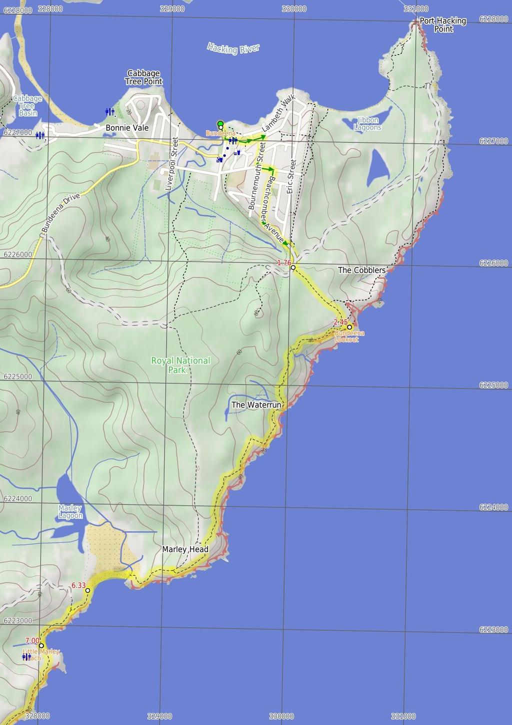
2 Bundeena Before You walk Bundeena is a small township at the northern end of Royal National Park and the southern side of the entrance to Port Hacking. The town can be accessed by car or ferry. There are a few B&B's and other accommodation options and a number of cafes to choose from. Bundeena has a mixed atmosphere, partly a beach holiday community but also home to some permanent residents. There are two main beaches - Hordens Beach to the west and Jibbon Beach to the east. Both are nice beaches inside Port Hacking. More info. Bushwalking is fun and a wonderful way to enjoy our natural places. Sometimes things go bad, with a bit of planning you can increase your chance of having an ejoyable and safer walk. Before setting off on your walk check Bundeena Lookout This unfenced, informal lookout is perched high on the cliffs, looking east over the South Pacific Ocean. The lookout is not signposted nor officially named, but provides great view south along the escarpment. Cliff edge may be unstable and fragile - keep a safe distance. Little Marley Beach Little Marley Beach, Royal National Park, is a yellow sand beach, approximately 140m long. The narrow beach faces north-east and has a rock platform at either end. The beach is not patrolled and has no other services. For information on this beach's pollution levels, follow the 'more info' link below. More info. Wattamolla Dam Wattamolla pool (or dam), Royal National Park, is a small water hole on Wattamolla Creek, above the lagoon. The pool is on the Coast Track near Wattamolla picnic area and offers a quiet spot for a dip and a rest. The pool is formed by a small, constructed sandstone dam and fed by a small waterfall above. Wattamolla Kiosk The Wattamolla Kiosk in the Wattamolla Picnic Area provides basic supplies for day visitors. The kiosk does not keep strict hours and opens depending on weather and demand. It usually opens on weekends at around 10:30am and closes between 4 and 6pm. You can buy ice-creams, drinks and some hot food. For more information, call Audley Kiosk on (02) ) Weather Forecast (BOM Metropolitan District) 2) Fire Dangers (Greater Sydney Region, Illawarra/Shoalhaven, unknown) 3) Park Alerts (Royal National Park) 4) Research the walk to check your party has the skills, fitness and equipment required 5) Agree to stay as a group and not leave anyone to walk solo Think before you TREK The 'Think before you TREK' program developed by NSW Police & NPWS promotes the benefits of planning ahead for your bushwalking trip by using an easy to remember acronym: adequate supplies of food, water, navigation and first T Take aid equipment. your planned route and tell friends and family when R Register you expect to return. beacon (PLB's) should be carried on walks with E Emergency significant gaps in mobile coverage (check terrain profile). to your planned route and follow the map and walking K Keep trails. Topo Maps The maps provided on wildwalks are helpful, but there are times where you may need maps covering a broader area. Maps that cover this walk include; 1: Map Series:91294S OTFORD, 91294N PORT HACKING 1: Map Series:9129 PORT HACKING Grade This walk has been graded using the AS The overall grade of the walk is dertermined by the highest classification along the whole track. 4 Grade 4/6 Hard track Length 27.4 km One way Time 2 Days Quality of track Formed track, with some branches and other obstacles (3/6) Signs Directional signs along the way (3/6) Experience Required Some bushwalking experience recommended (3/6) Weather Weather generally has little impact on safety (1/6) Infrastructure Limited facilities, not all cliffs are fenced (3/6)
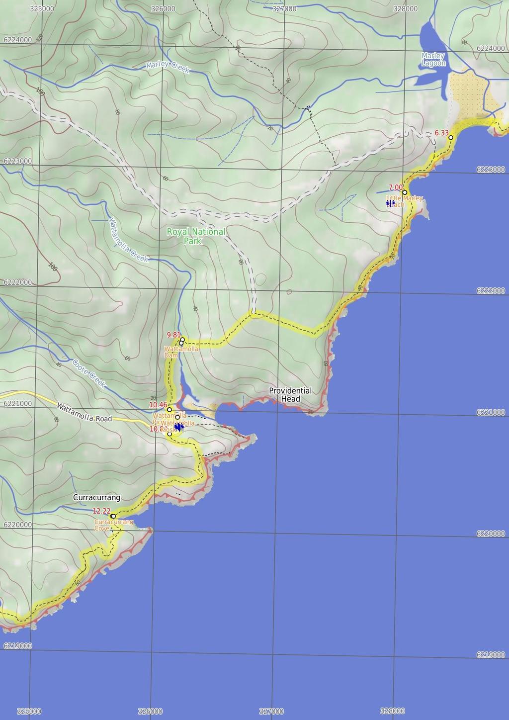
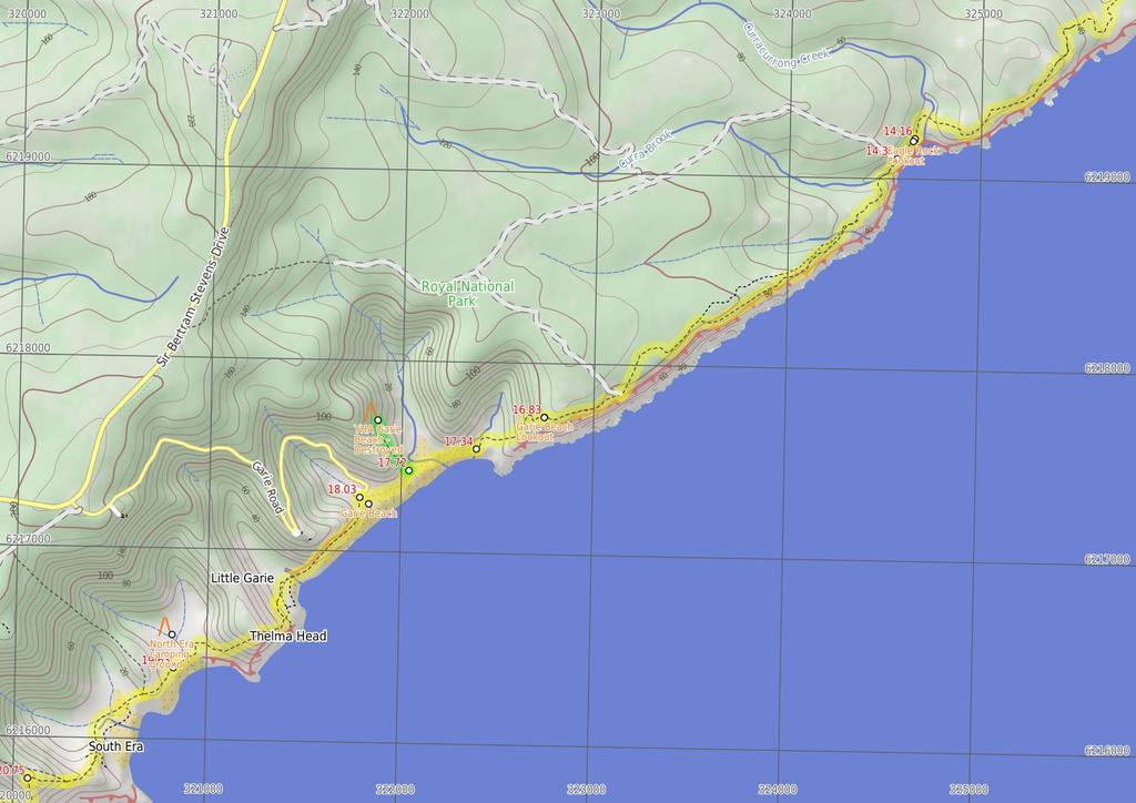
3 Are you ready to have fun? Please ensure you and your group are well prepared and equipped for all possible hazards and delays. Check park closures, weather information and Fire Danger Rating before setting out. Optional side trips and alternate routes noted are not included in this walks overall grade, length or time estimate. Please allow extra time for resting and exploring areas of interest. The authors, staff and owners of wildwalks take care in preparing this information but will not accept responsibility for any inconvenience, loss or injury you may experience. Please take care, have fun - Happy Walking. Getting there You can get to Bundeena Ferry Wharf (gps: , ) by car or ferry. Car: There is free parking available. You can get back from Otford Train Station (gps: , ) by car or train. Car: There is free parking available. Find up to date and more information inlcuding; travel directions, weather, park closures and walker feedback at 0 Bundeena Bundeena is a small township at the northern end of Royal National Park and the southern side of the entrance to Port Hacking. The town can be accessed by car or ferry. There are a few B&B's and other accommodation options and a number of cafes to choose from. Bundeena has a mixed atmosphere, partly a beach holiday community but also home to some permanent residents. There are two main beaches - Hordens Beach to the west and Jibbon Beach to the east. Both are nice beaches inside Port Hacking. More info. 0 Bundeena Ferry Wharf (1.8 km 34 mins) From Bundeena Ferry, on Brighton St, this walk turns left into Loftus St, goes past Mary St and turns right into Bournemouth St. The walk turns left into Scarbourough St and takes the first right into Beachcomber Av. Beachcomber Av is followed south and gradually to the east until reaching the entry into the Royal National Park. This is marked by several large information signs. Continue straight: From the end of Beachcomber Av, this walk heads around the locked gate, following the 'Coast Walk' sign along the wide management trail. After about 50m, the trail passes a track (on the left) and continues until coming to an intersection with a wider sandy trail (on the left, which leads to Jibbon Head). Continue straight: From the intersection, this walk follows the asphalt management trail heading towards the green signposts nearby, where it comes to the signposted intersection of the 'Coast Track' Int of Beachcomber Rd Servicetrail and Coast Walk (690 m 12 mins) Turn left: From the intersection, the walk follows the 'Coast Track' signpost along the wide, sandy bush track as it winds through the short, thick scrub for a while before arriving at the coast, where there are great views across the South Pacific Ocean Bundeena Lookout This unfenced, informal lookout is perched high on the cliffs, looking east over the South Pacific Ocean. The lookout is not signposted nor officially named, but provides great view south along the escarpment. Cliff edge may be unstable and fragile - keep a safe distance Bundeena Lookout (3.9 km 1 hr 19 mins) Turn right: From the lookout, this walk follows the bush track winding south along the coast line, keeping the ocean to the left as it winds in and out of scrub and across several rock surfaces. On a few occasions, the track will split into two and meet up again a short while later just stick to the track closer to the coast. This walk follows the track markers until coming to a large gully, where it winds to the bottom via some steep rock steps. Once at the bottom, the track crosses the small stream at the wooden bridge and continues up the other side of the gully, climbing up the wooden steps and the hardened path to the top. From the top of the gully, the track continues along the path heading through the high heath for about 1.5km, until coming to an intersection with a management trail. This intersection is marked by a signpost saying 'Coast Walk'. Veer left: From the signposted intersection, the walk follows the coast, keeping the ocean to the left. The track winds down the long hill to the end of Marley Beach, and comes to a large green information sign. Continue straight: From the end of Marley Beach, this walk follows the coast along the beach until coming to the rock-shelf at the end. Marley Beach is very beautiful and, on a warm day, it would be a great spot to swim. On the rockshelf at the end of the beach, there are some shady spots to break from the walk. (At this, point there is also an intersection with a small bush track that heads up the hill and away from the beach.) 6.33 West Marley Beach (680 m 12 mins) Veer left: From the end of the beach, this walk heads up and along the rock-shelf to following the coast as the bush track weaves in and out of the short heath for a short while. The track then comes to an intersection with an unmarked bush track going off to the right and away from the cliffs. Veer left: From the intersection, this walk follows the bush track winding along the coast, keeping the ocean and the cliffs to the left. The track winds down the hill for a while before coming to the end of Little Marley Beach. 7 Little Marley Beach Little Marley Beach, Royal National Park, is a yellow sand beach, approximately 140m long. The narrow beach faces north-east and has a rock platform at either end. The beach is not patrolled and has no other services. For information on this beach's pollution levels, follow the 'more info' link below. More info. 7 Little Marley Beach (2.8 km 1 hr 8 mins) Continue straight: From Little Marley Beach, this walk follows the coast across the beach, keeping the ocean to the left as it climbs up the signposted bush track at the end to the clifftop. From here, the track follows the coast line for a short period before passing over numerous sections of metal footbridge. This continues through the scrub vegetation, with short periods where the track comes back onto the rockshelf above the cliff, until the track changes to purely being a well-managed bush track through the high scrub, as it winds along to the signposted intersection of the Coast Track. Veer left: From the intersection, this walk heads south-west along the bush track, heading down the long hill through the high scrub and down through some rocks, as it approaches the small swimming hole made by the dam in Wattamolla Creek Wattamolla Dam Wattamolla pool (or dam), Royal National Park, is a small water hole on Wattamolla Creek, above the lagoon. The pool is on the Coast Track near Wattamolla picnic area and offers a quiet spot for a dip and a rest. The pool is formed by a small, constructed sandstone dam and fed by a small waterfall above Wattamolla Dam (650 m 13 mins) Continue straight: From the creek, (which may become impassable after heavy or prolonged rain) this walk heads west (keeping the swimming hole on the left) along the bush track. The walk winds through the tall scrub and down the long hill until crossing the wide, shallow creek to the Wattamolla Picnic Ground on the other side Wattamolla Kiosk The Wattamolla Kiosk in the Wattamolla Picnic Area provides basic supplies for day visitors. The kiosk does not keep strict hours and opens depending on weather and demand. It usually opens on weekends at around 10:30am and closes between 4 and 6pm. You can buy ice-creams, drinks and some hot food. For more information, call Audley Kiosk on (02) Wattamolla Picnic Area Wattamolla Picnic Area is found at the end of Wattamolla Road, about halfway along the coastline of Royal National Park. The area is blessed with a great beach, a lagoon and some wonderful creeks and rocks to explore. The small beach faces west and is tucked away in a deep bay. The lagoon sits behind the beach and is lined with sand on one side, and cliffs and rocks on the other shore. The picnic area has large open grassy areas, with some shade provided by trees and some picnic shelters. There is a small kiosk (often open weekends), toilets, electric BBQs and two car parks. There is water here, but needs to be treated before drinking. There is a gate on the road that is locked at night, the gate is open from 7am to 8:30pm Northern End Wattamolla Picnic Ground (340 m 8 mins) Continue straight: From the northern end of the picnic ground, this walk heads through the car park and across the grass to the toilet block. Turn right: From the toilet block, this walk follows the signs to the Overflow Car Park. (This is the upper car park.) At the back of the car park, this walk comes to an intersection with a large management trail, with a gate and signpost saying 'Garrie 5.8km' Overflow Carpark (1.4 km 26 mins) Turn left: From the car park, the walk follows the management trail climbing up the long hill. The walk passes two large water towers as it continues along for a while, before coming to a great lookout over the ocean, marked by a sign saying 'Curracurrang'. From the lookout, the walk continues along the cliff edge, keeping the ocean to the left as it follows the bush track. The track winds along the coast to Curracurrang Cove, where there is an intersection with another bush track that heads up and away from the ocean Curracurrang Cove Curracurrang Cove is a small cove about 1km SW of Wattamolla, on the coast of the Royal National Park. The cove faces east and is where Curracurrang Creek meets the ocean. The creek, the cove and the surrounding rocks provide great scenery, making this a relaxing place to stop and enjoy. There is evidence that Aboriginal people lived in this cove. There are a few middens in the area, some rock shelters and Curracurrang creek provides a near-permanent water supply. The cove was first occupied 7500 years ago and was used as a regular campsite by the Dharawal people. More info Curracurrang Cove (1.9 km 44 mins) Turn left : Keeping the ocean to the left, the track climbs up out of Curracurang Cove and continues all the way up to the top of the large hill, winding through the thick heath across the top and down the other side to Curracurang Creek at the bottom. After crossing the creek, the track follows the bushtrack heading up short hill and along the bushtrack winding through the scrub for a short while before coming to the Eagle Rock lookout at the information signpost Eagle Rock Lookout Eagle Rock lookout is an informal lookout marked by an information sign on the Coast track in the Royal National Park. The lookout is about halfway
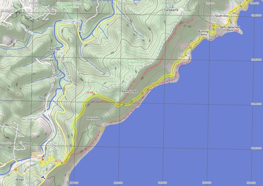
4 between Garie Beach and Wattamolla. Eagle rock is a piece of the cliff line that looks amazingly like the head of an eagle, with the eye and all. The lookout is about 150m west of the Eagle Rock on the other side of Carracurrong Creek. Eagle Rock is often used as an icon for the Royal National Park. Carracurrong Creek also forms a waterfall into the ocean nearby Eagles Rock Lookout (140 m 3 mins) Continue straight: Keeping the ocean to the left the track follows the bushtrack heading through the heath along the coast for a short while until it comes to the intersection of the bushtrack at the end of the service trail, marked by the two post's where the sign has been pulled off Int. Coastal Walk and Curra Moors Brook Trail (2.5 km 54 mins) Continue straight: From the intersection, this walk heads along the bush track and the rockshelf, keeping the ocean on the left. This continues, with the track becoming a narrow trail that goes through the scrub. In various sections, metal walkways have been built to stabilise the environment in the area. This continues until reaching an intersection with a track, heading off to the right. Continue straight: From the intersection, this walk follows the bush track around the left-hand side of the 'Curra Moors car park' sign, following the cliffs and keeping the ocean on the left of the track. After several hundred metres of high scrub, the track emerges out into the opening which has fantastic views of Garie Beach and the hills to the south Garie Beach Lookout Garie Beach Lookout is an unofficial lookout on the hill at the eastern end of Garie Beach. The lookout has no facilities and is simply a spot on the Coast track. The lookout provides great views looking southwest along the coast along Garie Beach, Royal National Park and down to Wollongong Garie Beach Lookout (510 m 13 mins) Continue straight: From Garie Beach Lookout, this walk follows the bush track heading down towards Garie Beach, winding down the long hill, descending the steep rock and wooden steps to the bottom of the hill where the walk continues through the grassy clearing to the end of the beach North-East End of Garie Beach (380 m 7 mins) Continue straight: From the end of Garie Beach, the walk follows the coast across the beach, keeping the ocean to the left until coming to the base of some timber steps, which lead up the hill on the right Optional sidetrip to Garie Beach YHA (340 m 10 mins) Veer right: From the intersection, this walk follows the stairs away from the ocean. The track winds up the hill steeply then continues for approximately 350m along the hillside, in and out of a gully, to rise up to the cabin signposted as 'YHA Garie Beach'. At the end of this side trip, retrace your steps back to the main walk then Turn right YHA Garie Beach - Destroyed **On 02/12/2010 this hut was completely destroyed by fire and plans for the future are not yet decided. Accommodation no longer available Garie Beach YHA Youth Hostel, in Royal National Park, is a basic but comfortable cabin. The unstaffed and locked cabin is situated north of Garie Beach car park, high on the hill behind the next gully. The cabin contains solar lighting, water, gas kitchen, a 'loo with a view' and the capacity to sleep twelve people. You need to provide your own bed sheets and toilet paper. The cabin costs $17.50/adult per night, with the potential to rent the youth hostel out for a week. The key must be picked up from YHA Kent St, Sydney, prior to arrival at the YHA. The key has a $50.00 deposit. To make a booking phone More info Int. Garie Beach YHA Trk (310 m 6 mins) Veer left: From the intersection, the walk heads along the beach, keeping the ocean on your left, for approximately 200m to Garie Beach car park on the right Garie Beach Garie Beach, Royal National Park, is a large, south-east facing, yellow sand beach. The beach is backed by steep headlands and gullies. There is a large car park at the end of Garie Rd for access to the beach. Garie Beach is popular for surfing, patrolled 9am-5pm from December to January. Facilities include toilets, kiosk, picnic tables, cold showers and Surf Life Saving Club. The water from the shower should be treated before drinking, this water comes from a tank and may be unavailable during dry periods. More info Garie Beach Car Park (1.6 km 43 mins) Turn left: From the Garie Beach car park, the walk follows the sign to 'North Era', keeping the sea to the left. This track follows the base of the large grassy hill between the rocks and the ocean, to the Little Garie cabins and up past the Little Garie Community Hall. Continue straight: From the community hall in Little Garie, the walk heads steeply up the hill, following the track to the south-west. To prevent erosion of the hill, wooden steps have been installed. From the top of the ridge, the track continues down the other side, keeping the ocean on the left while winding down into North Era Bush Campground North Era camping ground North Era camping ground, Royal National Park, is a large dune area situated directly behind North Era Beach. This camping spot is popular with surfers, and it also has a toilet and a cleared area to pitch your tent. A maximum of 36 people (12 sites) can camp here, so there is plenty of room for everyone. Open fires are not permitted, you can carry a fuel stove for cooking. A camping permit is required from NPWS before arriving (Phone:(02) ). Water is often available from the creek (treat before drinking), If dry you can walk to Garie Beach for water, although the water here may also be dried up, during a dry period it is best to carry all your water with you End of day 1 This is the planned overnight stay for the end of day 1, happy camping.
5 the steps to the station North Era Bush Campground (1.1 km 27 mins) Continue straight: From the North Era Bush Campground, the walk heads up the grassy hill, keeping the ocean to the left. Just before the buildings, the walk comes to an intersection with a track on the right (which heads into the trees). Continue straight: From the top of the ridge, the walk heads down the hill, keeping the ocean to the left as it winds down between the cabins to the beach at the bottom. From here, the walk continues around the back of the beach following the coast, and up between the houses to the large clearing before the top of the hill. Here, the walk comes to an intersection with two rough bush tracks towards the top of the hill. Continue straight: From the intersection, this walk heads up the hill and through the ferns, heading up and away from the cabins but still keeping the sea to the left of the track. This continues until the track comes to a large sign saying 'Coast Track' Int of Coast Track and Burgh Ridge Track (Sth) (940 m 18 mins) Turn left: From the intersection, this walk follows the sign to 'Burning Palms' along the bush track, winding down the side of the hill, past the cabins, then at the bottom the track joins onto a metal walkway that soon changes to a narrow bush track. This passes behind Burning Palms Beach until coming to a sign saying 'Otford via Palm Jungle' Burning Palms Beach (southern end) (3 km 1 hr 20 mins) Veer right: From the intersection near the rangers' hut, the walk follows the 'Otford' signpost along the defined bush track up and along the coast. After walking through grasslands for some time, the track comes to a very faint intersection with the Figure Eight Pool's track, just before the dense palm jungle. Continue straight: From the intersection, this walk follows the bush track heading up into the palm jungle. After entering the jungle, the track is quite clear but in some places there are obstacles, such as fallen trees and branches. The track continues in this manner for some time before turning inland and climbing steeply up to the top of the large hill. At the top, the track flattens out and heads towards the ocean, soon arriving at an intersection with a management trail. At this point there are several signposts pointing towards 'Otford' and 'Carawarra Farm' The Squeeze Way and Burning Palms Tracks (1.9 km 43 mins) Turn left: From the intersection, the track follows the Otford arrow down the service trail, as it winds through the bush to the end where it becomes a bush track. From here, the track continues along the wellmanaged bush track through a beautiful section of ferns. After a while, this begins to gradually descend until reaching an intersection marked with a signpost for 'Werrong Beach'. Continue straight: From the intersection, this walk follows the bush track, winding down the hill for a short while before coming to the fenced-off edge of the cliffs, which it follows keeping the ocean to the left as it winds down the hill. After a while, the track changes back to a bush track and continues down some wooden stairs to a car park signposted as 'Otford Lookout' Otford Lookout (800 m 24 mins) Veer left: From the lookout and the car park, this walk follows the 'Otford Station' sign along Lady Wakehurst Drive to quickly meet Fanshawe Rd. This walk turns right onto Fanshawe Rd, which it follows down the long hill until it comes to the intersection of Station St. At the intersection, this walk turns left and continues along the road, passing the intersection with another road heading down to the right and coming to the 'T' intersection of the next dirt road. From here, the walk continues down the hill following the 'Otford Station' signs down the steep concrete path, and down
6
7
8
9
10 Summary navigation sheet for the The Coast Track km From Start Bundeena Ferry Wharf , (GR Port Hacking, ) 1.76 Int of Beachcomber Rd Servicetrail and Coast Walk , (GR Port Hacking, ) Bundeena Lookout , (GR Port Hacking, ) West Marley Beach , (GR Port Hacking, ) Little Marley Beach , (GR Port Hacking, ) Wattamolla Dam , (GR Otford, ) Northern End Wattamolla Picnic Ground , (GR Otford, ) Overflow Carpark , (GR Otford, ) Curracurrang Cove , (GR Otford, ) Eagles Rock Lookout , (GR Otford, ) Int. Coastal Walk and Curra Moors Brook Trail , (GR Otford, ) Garie Beach Lookout , (GR Otford, ) North-East End of Garie Beach , (GR Otford, ) Int. Garie Beach YHA Trk , (GR Otford, ) Int. Garie Beach YHA Trk , (GR Otford, ) Garie Beach Car Park , (GR Otford, ) End of day , (GR Otford, ) North Era Bush Campground , (GR Otford, ) Up/Dwn Length Initial directions (Use full tracknotes and maps for more detail) km 34 mins 690 m 12 mins From Bundeena Ferry, on Brighton St, this walk turns left into Loftus St, goes past Mary St and turns right into Bournemouth St. Turn left: From the intersection, the walk follows the 'Coast Track' signpost along the wide, sandy bush track as it winds through the short, thick scrub for a while before arriving at the coast, where there are gre km 1 hr 19 mins 680 m 12 mins 2.8 km 1 hr 8 mins 650 m 13 mins 340 m 8 mins 1.4 km 26 mins 1.9 km 44 mins 140 m 3 mins 2.5 km 54 mins 510 m 13 mins Turn right: From the lookout, this walk follows the bush track winding south along the coast line, keeping the ocean to the left as it winds in and out of scrub and across several rock surfaces. Veer left: From the end of the beach, this walk heads up and along the rock-shelf to following the coast as the bush track weaves in and out of the short heath for a short while. Continue straight: From Little Marley Beach, this walk follows the coast across the beach, keeping the ocean to the left as it climbs up the signposted bush track at the end to the clifftop. Continue straight: From the creek, (which may become impassable after heavy or prolonged rain) this walk heads west (keeping the swimming hole on the left) along the bush track. Continue straight: From the northern end of the picnic ground, this walk heads through the car park and across the grass to the toilet block. Turn left: From the car park, the walk follows the management trail climbing up the long hill m 7 mins 340 m 10 mins 310 m 6 mins 1.6 km 43 mins 0m Continue straight: From the end of Garie Beach, the walk follows the coast across the beach, keeping the ocean to the left until coming to the base of some timber steps, which lead up the hill on the right. Optional sidetrip to Garie Beach YHA. Veer right: From the intersection, this walk follows the stairs away from the ocean. Veer left: From the intersection, the walk heads along the beach, keeping the ocean on your left, for approximately 200m to Garie Beach car park on the right. Turn left: From the Garie Beach car park, the walk follows the sign to 'North Era', keeping the sea to the left. 1.1 km 27 mins Continue straight: From the North Era Bush Campground, the walk heads up the grassy hill, keeping the ocean to the left. Turn left : Keeping the ocean to the left, the track climbs up out of Curracurang Cove and continues all the way up to the top of the large hill, winding through the thick heath across the top and down the other sid... Continue straight: Keeping the ocean to the left the track follows the bushtrack heading through the heath along the coast for a short while until it comes to the intersection of the bushtrack at the end of the serv... Continue straight: From the intersection, this walk heads along the bush track and the rockshelf, keeping the ocean on the left. Continue straight: From Garie Beach Lookout, this walk follows the bush track heading down towards Garie Beach, winding down the long hill, descending the steep rock and wooden steps to the bottom of the hill where... This is the planned overnight stay for the end of day 1, happy camping.
11 Summary navigation sheet for the The Coast Track km From Int of Coast Track and Burgh Ridge Track (Sth) , (GR Otford, ) Burning Palms Beach (southern end) , (GR Otford, ) The Squeeze Way and Burning Palms Tracks , (GR Otford, ) Otford Lookout , (GR Otford, ) Powered by TCPDF ( Up/Dwn Length Initial directions (Use full tracknotes and maps for more detail) m 18 mins 3 km 1 hr 20 mins 1.9 km 43 mins 800 m 24 mins Turn left: From the intersection, this walk follows the sign to 'Burning Palms' along the bush track, winding down the side of the hill, past the cabins, then at the bottom the track joins onto a metal walkway that... Veer right: From the intersection near the rangers' hut, the walk follows the 'Otford' signpost along the defined bush track up and along the coast. Turn left: From the intersection, the track follows the Otford arrow down the service trail, as it winds through the bush to the end where it becomes a bush track. Veer left: From the lookout and the car park, this walk follows the 'Otford Station' sign along Lady Wakehurst Drive to quickly meet Fanshawe Rd.
Wattamolla to Big Marley Beach
 Wattamolla to Big Marley Beach 4 hrs 10.4 km Circuit Moderate track 4m This walk is an excellent loop which takes in both the coast and the heathy inland of Royal National Park. Nearly the whole walk has
Heathcote to Engadine via Audley
 Heathcote to Engadine via Audley 6 hrs 3 mins 5 km One way Hard track 4 635m Covering a large section of central Royal National Park, this walk goes through the heath and scrub along a well managed and
Waterfall to Heathcote
 Waterfall to Heathcote 5 hrs Hard track 10.8 km One way 4 467m This walk explores the heart of Heathcote National Park, and is easily accessed with a train station at either end. Although relatively close
Campbell Drive to Snapper Point
 Campbell Drive to Snapper Point 1 hr 45 mins 4.2 km One way Experienced only 135m This walk follows the Coast Track to Frazer Beach, along the Geebung and (overgrown) Grass Tree Tracks. From the northern
Wentworth Falls Conservation Hut Loop
 Wentworth Falls Conservation Hut Loop 3 hrs Hard track 6.7 km Circuit 4 341m This scenic walk from Wentworth Falls Station, winds along the Nature Trail to Conservation Hut, then drops into the magnificent
Carrington Park to Leura Forest and pass loop
 Carrington Park to Leura Forest and pass loop 3 hrs Hard track 4.8 km Circuit 4 674m This walk is a fantastic way to see Leura Forest. The walk descends from Carrington Park, visiting Leura Forest and
Popes Glen, Pulpit Rock, Govetts Leap and Braeside Walk
 Popes Glen, Pulpit Rock, Govetts Leap and Braeside Walk 8 hrs Hard track 13.6 km Circuit 4 1068m This large circuit walk, from Popes Glen to Pulpit Rock, Govetts leap and along the Braeside Track, passes
Sid Pulsford Walk. 175m. 33m. 1 hr 45 mins 4.1 km One way. Hard track 118m. Gosford LGA
 Sid Pulsford Walk 1 hr 5 mins.1 km One way Hard track 118m Sid Pulsford Walk explores the ridge top of Kincumber Mountain, from Honeman's Rock to Green Point. The walk mostly follows wide management trails.
Morgans Creek to Padstow
 Morgans Creek to Padstow 2 hrs 45 mins 8 km One way Moderate track 3 144m This pleasant walk starts from the Morgans Creek park, at Henry Lawsons Drive, and follows the Georges River past the Boomerang
Currie Rd to Davidson Park
 Currie Rd to Davidson Park 3 hrs 7.2 km One way Moderate track 28m Starting at Currie Rd in Forestville, this walk follows Middle Harbour to Davidson Park, under Roseville Bridge. There are two optional
Wallarah Coastal Walk
 Wallarah Coastal Walk 3 hrs 8.3 km Return Hard track 247m This walk starts at Caves Beach and travels south along the coastline, until reaching the Pinney s Headland Lookout. There are many opportunities
The Basin Track and Mackerel Track
 The Basin Track and Mackerel Track 3 hrs 5.9 km Circuit Hard track 226m This walk is a great way to see some popular areas in Ku-ring-gai Chase National Park. The walk from West Head Rd travels to The
Epping to Pennant Hills Station (via Lane Cove River)
") Epping to Pennant Hills Station (via Lane Cove River) 3 hrs 5 mins 8.4 km One way Hard track 249m This walk, from Epping to Pennant Hills Station, is a great way to see the upper Lane Cove River Valley.
Epping to Pennant Hills Station (via Lane Cove River) 3 hrs 5 mins 8.4 km One way Hard track 249m This walk, from Epping to Pennant Hills Station, is a great way to see the upper Lane Cove River Valley.
Govetts Leap Loop. 1065m. 909m Blue Mountains National Park. 4 hrs 30 mins 8.7 km Circuit. Hard track 380m
 Govetts Leap Loop 4 hrs 30 mins 8.7 km Circuit Hard track 380m This walk, from Blackheath Train Station, is a fantastic way to see some of the iconic areas of the Blue Mountains in the Blackheath area.
Echo Point to Leura Forest via Three Sisters and Giant Stairs loop
 Echo Point to Leura Forest via Three Sisters and Giant Stairs loop 3 hrs 3.8 km Circuit Hard track 512m This walk starts from the popular Echo Point, in Katoomba, and winds down to the base of the Three
Little Digger Track to Davidson Reserve and Lyrebird Circuit
 Little Digger Track to Davidson Reserve and Lyrebird Circuit 4 hrs 3 mins 11.5 km One way Hard track 4 47m Exploring both the eastern and western sides of Middle Harbour Creek, this walk follows the Little
Little Digger Track. 68m. 1 Hr 2.2 km One way. Moderate track 93m. Moores Creek Reserve
 Little Digger Track Hr 2.2 km One way Moderate track 93m This walk follows Moores Creek through several reserves in east Roseville and East Lindfield. The track is named after Australia's 7th Prime Minster,
Rail to River Walk. 3 hrs. Hard track 7.5 km Circuit. 222m
 Rail to River Walk 3 hrs Hard track 7.5 km Circuit 4 222m This walk is a great one from Chatswood Station to the Lane Cove River National Park. The walk descends through the vegetated bushland which fills
Katoomba Falls Circuit
 Katoomba Falls Circuit hr 5 mins.5 km Circuit Hard track 59m For those looking for a walk involving more than simple boardwalk, this trail winding through the temperate rain forest could be just the thing.
Mackerel Beach, West Head Loop
 Mackerel Beach, West Head Loop 5 hrs 8.6 km Circuit Hard track 422m The Mackerel Beach, West Head Loop is a walk which explores a large part of the West Head. The journey starts and finishes with a ferry
Mackerel Beach and Resolute Loop
 Mackerel Beach and Resolute Loop 3 hrs 5.4 km Circuit Hard track 384m This walk is another great walk in Ku-ring-gai Chase National Park, accessed by ferry. From the Mackerel Beach wharf, this walk uses
Hunters Hill to Epping Road
 Hunters Hill to Epping Road 2 hrs 30 mins 5.5 km One way Moderate track 154m An enjoyable walk through lower sections of the Lane Cove National Park, this walk features plenty of mangroves next to the
Bouddi Coastal Walk. 5 hrs. Hard track 8.1 km One way. 364m
 Bouddi Coastal Walk 5 hrs Hard track 8.1 km One way 4 364m This is one of the longer walks in the Bouddi National Park and it is rich in scenery. The walk follows the coastline with many side trips to
The Foreshore Walk. 24m. 1m Lake Macquarie LGA. 1 hr 15 mins 2.9 km One way. Hard track 81m
 The Foreshore Walk 1 hr 15 mins 2.9 km One way Hard track 81m This walk traverses the coastline of the Green Point reserve. By following a variety of tracks and occasionally traveling inland through eucalyptus
Balmoral Beach to The Spit
 Balmoral Beach to The Spit 2 hrs 30 mins.3 km One way Hard track 85m This walks follows the coast from Balmoral to the Spit and across Spit Bridge. There are some alternate tracks to consider at high-tides,
Epping to Eastwood Station (via Lane Cove River)
") Epping to Eastwood Station (via Lane Cove River) hrs 45 mins 10.2 km One way Moderate track 189m Epping to Eastwood, via Lane Cove River, is the longer route through the bush between the stations. This
Epping to Eastwood Station (via Lane Cove River) hrs 45 mins 10.2 km One way Moderate track 189m Epping to Eastwood, via Lane Cove River, is the longer route through the bush between the stations. This
Callicoma Loop. 174m. 98m. 2 hrs. Hard track 5.1 km Circuit. 153m
 Callicoma Loop 2 hrs Hard track 5.1 km Circuit 153m This great circuit walk passes through some really nice forest around the fringe of Cherrybrook. Highlights of the walk include some beautiful rock overhangs
Hornsby Blue Gum Walk
 Hornsby Blue Gum Walk 3 hrs Hard track 6.7 km Circuit 4 374m This delightful loop is one of the prettiest and most popular walks in the Hornsby area. Going from an environment of ferns and clear bushland
Teralba to Charlestown Park track head
 Teralba to Charlestown Park track head 4 hrs 30 mins 13.3 km One way Moderate track 3 220m This section of the Great North Walk starts from the Teralba train station and winds down and around the edge
Dead Horse Gap Loop track
 Dead Horse Gap Loop track 4 hrs 30 mins Hard track 9.8 km Circuit 144m 4 This walk starts with a ride up the Kosciuszko Express Chairlift. There is an opportunity to eat at Australia's highest restaurant,
National Pass from Wentworth Falls to Conservation Hut
 National Pass from Wentworth Falls to Conservation Hut 3 hrs Hard track 3.6 km One way 739m Starting at Wentworth Falls picnic area, this scenic and historic walk explores many waterfalls, lookouts and
Scenic World to Echo Point
 Scenic World to Echo Point 1 hr 15 mins 2.1 km One way Moderate track 192m This is one of the most popular tourist walks in the Katoomba area. The walk follows the cliffs along a well maintained and signposted
Blackheath Station to Junction Rock Loop (via Grand Canyon and Popes
 Blackheath Station to Junction Rock Loop (via Grand Canyon and Popes 8 hrs 30 mins 18.2 km Circuit Hard track 4 1254m This circuit starts in Blackheath and heads down into the Grand Canyon and Rodriguez
Epping to Gordon Station
 Epping to Gordon Station 4 hrs 15 mins 11.7 km One way Hard track 4 365m This walk, from Epping Station to Gordon Station, passes below the homes which sit on the hills high above the Lane Cove River.
Middle Harbour Creek Loop
 Middle Harbour Creek Loop 5 hrs 45 mins 15.1 km Circuit Experienced only 5 570m This walk explores the upper reaches of Middle Harbour Creek, starting and ending at the great parklands at Davidson Park,
Rail to River and Stringybark Creek Reserve Walk
 Rail to River and Stringybark Creek Reserve Walk 4 hrs Hard track 11.2 km Circuit 4 302m This walk begins in the busy city of Chatswood and soon enters the nearby bushland around the Lane Cove River. The
Spit Bridge to Middle Head Forts
 Spit Bridge to Middle Head Forts 2 hrs 30 mins 6.3 km One way Hard track 4 181m This scenic walk takes you from the Spit Bridge, along the coast to explore the Middle Head Forts. There are a few alternate
Berowra to Mt Kuring-gai
 Berowra to Mt Kuring-gai 4 hrs 30 mins 9.4 km One way Hard track 4 551m From the ridges above Cowan Creek, this walk takes in some great lookouts (especially around Mt Kuringgai) as well as enjoying an
De Burgs Bridge to Thornleigh station
 De Burgs Bridge to Thornleigh station 3 hrs 45 mins 9.7 km One way Hard track 4 363m This walk follows a section of the Great North Walk, starting from De Burghs bridge. The walk winds north west, through
Green Point Circuit Walk
 Green Point Circuit Walk 3 hrs 7.7 km Circuit Hard track 269m This walk visits all of the popular locations in Green Point Reserve, as well as some of the lesser-visited areas inland. Taking in Sea Eagle
Upper Rumbalara circuit
 Upper Rumbalara circuit 1 hr 30 mins 3.3 km Circuit Hard track 176m A great circuit walk, covering most of the walking tracks and sights in the upper section of the Rumbalara Reserve. There is some really
De Burghs Bridge to Fullers Bridge
 De Burghs Bridge to Fullers Bridge 2 hrs 3 mins Hard track 6 km One way 2m 4 Following the Lane Cove River, this walk mostly follows a section of the Great North Walk and is well maintained and signposted.
Sphinx, Warrimoo and Bobbin Head tracks
 Sphinx, Warrimoo and Bobbin Head tracks 4 hrs 9.6 km Circuit Moderate track 499m This great walk starts at the Sphinx Memorial and loops around via Cowan Creek, exploring diverse environments as it changes
Patonga to Woy Woy. 5 hrs 45 mins 15.5 km One way. Hard track. 497m
 Patonga to Woy Woy 5 hrs 45 mins 15.5 km One way Hard track 4 497m This walk explores a variety of environments from the shore line and coastal cliffs near Patonga, to the dry, rocky and open ridge line.
Under and Over Cliff Walk
 Under and Over Cliff Walk 4 hrs 9.4 km Circuit Moderate track 576m This walk from Wentworth Falls Station is a fantastic way to see a large majority of the Wentworth Falls cliffline. The track winds under
Federal Pass Walking Track
 Federal Pass Walking Track 5 hrs Hard track 8 km One way 4 989m This classic trail follows along the base of the cliffs from Leura to the Golden Stairs, passing many of the more popular sights of the Katoomba
Glenbrook and Euroka Circuit
 Glenbrook and Euroka Circuit 2 Days 16.6 km Circuit Experienced only 790m This two day circuit, returning to Glenbrook Station, is a scenic walk which passes many of the tourist attractions within the
Woolwich Wharf to Boronia Park
 Woolwich Wharf to Boronia Park 2 hrs 5.8 km One way Moderate track 175m Going through the streets of Hunters Hill, this walk is on the first segment of the Great North Walk. The majority of the walk is
Dubbo Gully and Ten Mile Hollow Circuit (via Clares Bridge)
") Dubbo Gully and Ten Mile Hollow Circuit (via Clares Bridge) 2 Days Hard track 24.3 km Circuit 4 1117m This two day (or ten hour) walk follows several historic roads, now closed to traffic. Starting with
Dubbo Gully and Ten Mile Hollow Circuit (via Clares Bridge) 2 Days Hard track 24.3 km Circuit 4 1117m This two day (or ten hour) walk follows several historic roads, now closed to traffic. Starting with
Echo Point to Leura Forest Circuit
 Echo Point to Leura Forest Circuit 3 hrs 4.8 km Circuit Hard track 588m Forming a circuit around the cliffs and then the valley floor, this is a walk more then capable of convincing a walker of the beauty
Wentworth Falls Station Loop (Undercliff Walk)
") Wentworth Falls Station Loop (Undercliff Walk) 4 hrs 3 mins Hard track 8.9 km Circuit 658m 4 This walk passes some stunning waterfalls and views into the Jamison Valley, following the cliff edges around
Wentworth Falls Station Loop (Undercliff Walk) 4 hrs 3 mins Hard track 8.9 km Circuit 658m 4 This walk passes some stunning waterfalls and views into the Jamison Valley, following the cliff edges around
Taronga Wharf to Chowder Bay
 Taronga Wharf to Chowder Bay 2 hrs 4.4 km One way Moderate track 246m Starting at Taronga Wharf, this walk passes many icons of Sydney, including Taronga Zoo, HMAS Sydney Mast, Chowder Bay. The walk also
Wentworth Falls Station Loop
 Wentworth Falls Station Loop 5 hrs 3 mins 9.5 km Circuit Hard track 4 13m The Wentworth Falls Station Loop takes in most of the upper tracks around Wentworth Falls. There are many scenic views near the
Hermitage Foreshore Track
 Hermitage Foreshore Track 1 Hr 2.2 km One way Moderate track 123m The Hermitage Foreshore Walk is a wonderful way to explore Sydney Harbour from the perspective of South Head. This walk starts from Nielsen
Spit Bridge to Manly (Manly Scenic Walkway)
") Spit Bridge to Manly (Manly Scenic Walkway) 3 hrs 45 mins 9.1 km One way Moderate track 349m The Spit to Manly walk is a classic bushwalk on Sydney's Northern Beaches. The walk follows a well-maintained
Spit Bridge to Manly (Manly Scenic Walkway) 3 hrs 45 mins 9.1 km One way Moderate track 349m The Spit to Manly walk is a classic bushwalk on Sydney's Northern Beaches. The walk follows a well-maintained
Roseville to Macquarie Park
 Roseville to Macquarie Park 3 hrs 3 mins 8.8 km One way Hard track 4 29m This walk starts at Roseville station and explores the streets and alleyways of Roseville before joining the main spine of the Great
Charlestown Park trackhead to Newcastle station
 Charlestown Park trackhead to Newcastle station 5 hrs 30 mins 12.1 km One way Hard track 4 287m This section of the Great North Walk starts from the Charleston Park track head and winds through the streets
Wentworth Falls Loop. 893m. 665m. 6 hrs 10.2 km Circuit. Hard track 1093m. Blue Mountains National Park
 Wentworth Falls Loop 6 hrs 1.2 km Circuit Hard track 193m This is a great walk, both in size and spectacular views. The walk makes its way from Wentworth Falls train station and drops off the plateau,
Gordon to Chatswood Station
 Gordon to Chatswood Station 4 hrs 30 mins 12.2 km One way Hard track 4 381m This walk is a great way to get into the bush without being far from civilisation. The walk wanders through untouched valleys
Faulconbridge to Blaxland
 Faulconbridge to Blaxland 2 Days Experienced only 15.2 km One way 5 693m This two-day walk, or very solid one-day walk, takes you from station to station, through lush, scenic forest in the lower Blue
Thornleigh to Hornsby
 Thornleigh to Hornsby 4 hrs Hard track 10.2 km One way 4 526m Starting at Thornleigh station you walk through suburban streets for a short while before diving into the bush at the southern end of Berowra
Lane Cove Tourist Park River Circuit
 Lane Cove Tourist Park River Circuit 5 hrs 12 km Circuit Hard track 383m This walk follows a large section of Lane Cove River. The walk follows the Riverside Walking track up the Lane Cove River to De
Rumbalara Explorer. 158m. 5m Rumbalara Reserve. 2 hrs 45 mins 6.1 km Circuit. Hard track 326m
 Rumbalara Explorer 2 hrs 5 mins 6.1 km Circuit Hard track 326m Pretty well the grand tour of the Rumbalara Reserve, this walk takes in much of the great scenery the reserve has to offer. The walk covers
Cape Banks Circuit. 50m. 2m Botany Bay National Park. 3 hrs 7.3 km Circuit. Hard track 190m
 Cape Banks Circuit 3 hrs 7.3 km Circuit Hard track 19m This Cape Banks Circuit has a lot to offer and is thoroughly recommended. The walking travels over beaches, through coastal forest and across exposed
Gosford to Lisarow. 202m
 Gosford to Lisarow 4 hrs 3 mins Hard track 11.3 km One way 4 479m This walk is a great way to explore the ridge-top bushland between Gosford and Lisarow. Passing through Rumbalara and Katandra Reserves,
Bouddi Ridge and Coastal Walk
 Bouddi Ridge and Coastal Walk 2 Days Hard track 27 km Circuit 4 126m This overnight walk takes in the majority of the magnificent Bouddi National Park. The walk starts from the pleasant Putty Beach camping
Sphinx to Mt Kuring-gai
 Sphinx to Mt Kuring-gai 4 hrs 45 mins 1.7 km One way Hard track 673m This walk starts at the Sphinx War Memorial and follows some well maintained and popular walking tracks down to Cowan Creek. Enjoy the
Scenic world to Three Sisters Loop via Furber Steps
 Scenic world to Three Sisters Loop via Furber Steps 5 hrs 5.8 km Circuit Hard track 722m This walk starts from the popular Scenic World, in Katoomba, and winds down the Furber steps into the Jamison Valley,
Light to Light Walk 2 days
 Light to Light Walk 2 days 2 Days Hard track 3.9 km One way 4 794m Over two days, this classic walk explores the coast from Boyd Tower to the Green Cape Lighthouse in the south. Hegartys Bay Camp is over
Bobbin Head Loop. 166m. 0m Ku-ring-gai Chase National Park. 5 hrs 12.9 km Circuit. Hard track 619m
 Bobbin Head Loop 5 hrs 12.9 km Circuit Hard track 619m This great circuit walk enjoys a variety of landscapes in Ku-ring-gai Chase National Park. The walk starts at the historic Sphinx war memorial and
Manly to Seaforth Oval
 Manly to Seaforth Oval 5 hrs 45 mins 13.7 km One way Moderate track 3 624m This walk follows the Manly to Spit Scenic Walkway, then continues past The Spit Bridge to Seaforth Oval. The walk provides magnificent
North Ryde Fairyland circuit
 North Ryde Fairyland circuit 2 hrs 30 mins Hard track 6.9 km Circuit 193m 4 Starting at North Ryde train station this walk explores a stretch of the Lane Cove River, visiting the historic Fairlylands Pleasure
Chatswood to Epping Station
 Chatswood to Epping Station 6 hrs Hard track 16.3 km One way 4 533m This walk, from Chatswood to Epping, is a long but enjoyable walk along the Lane Cove valley. The walk mostly follows the Lane Cove River
Narrabeen Lagoon Trail (from Middle Creek)
") Narrabeen Lagoon Trail (from Middle Creek) 2 hrs 30 mins 8.6 km Circuit Very easy 1 105m The Narrabeen Lagoon Trail is a wonderful and accessible walk on the Northern Beaches of Sydney. The trail is used
Narrabeen Lagoon Trail (from Middle Creek) 2 hrs 30 mins 8.6 km Circuit Very easy 1 105m The Narrabeen Lagoon Trail is a wonderful and accessible walk on the Northern Beaches of Sydney. The trail is used
Taronga Zoo to Spit Bridge
 Taronga Zoo to Spit Bridge 5 hrs Hard track 1.4 km One way 4 41m This is a scenic and culturally rich walk with views over Sydney Harbour and many interesting heritage buildings along the way. The start
Six Foot Track. 1212m
 Six Foot Track 3 Days 44.8 km One way Hard track 4 2066m This classic walk takes you from Katoomba to Jenolan Caves via a historic horse route. The walk travels mainly along well-maintained service tracks
Sydney to Thornleigh via Lane Cove Tourist Park
 Sydney to Thornleigh via Lane Cove Tourist Park 2 Days 33 km One way Hard track 4 1114m This overnight walk starts from the Obelisk in Macquarie Park, Sydney, at the official start of the Great North Walk.
Detailed maps, and portaging and camping information follow.
 Overview of Bain route. The launch site is at Davidson Lake, just before the Manitoba/Ontario border. You can do a loop if you leave a vehicle at Tulabi Lake (at the canoe route parking lot). The road
SELF GUIDED TOURING ROUTE
 SELF GUIDED TOURING ROUTE Things to see and places to go on the loop from Orbost to Marlo, Cape Conran, Cabbage Tree and back to Orbost (or onwards to Cann River) V6 April 2017 This guide should be read
Beautiful Walks from the Blue Ball Inn
 Walk No. 7 COAST AND VALLEY WALK Countisbury, Glenthorne, County Gate, Brendon, Rockford and Wilsham 10 MILES APPROX. Walking time 5 hours approx. (not including breaks)> OS Sheet 64/74 Lynton and Lynmouth.
No accommodation included. You book your own accommodation in Apollo Bay (depending on your budget). Medium 6 hrs Lovely en suite
. Medium 6 hrs Lovely en suite") (WB3) Three day hike: Castle Cove to the 12 Apostles, Catered or Self Catered 2 nights accommodation- (Or option to extend your stay with an additional night in Port Campbell) Daily departures subject
(WB3) Three day hike: Castle Cove to the 12 Apostles, Catered or Self Catered 2 nights accommodation- (Or option to extend your stay with an additional night in Port Campbell) Daily departures subject
cabin with spa surrounded by bush and paddocks 7 hrs Lovely en suite cabin with spa surrounded by bush and paddocks included in Apollo Bay
 (WB3) Three day hike: Castle Cove to the 12 Apostles, Catered or Self Catered 2 nights accommodation- (Or option to extend your stay with an additional night in Port Campbell) Daily departures subject
Rhossili - Tears Point - Mewslade Bay - Talgarth's Well - Rhossili - ID: 148. Walk description:
 Walk description: A glorious walk combining thrilling cliffs with beautiful wild beaches and a bird's-eye view of the Gower peninsula from Rhossili Down. The adventurous can walk out to the Worm's Head
Upstreampaddle 25.South arm of the Brunswick River, Simpson s Creek drains the freshwater swamp lands of Tyagarah Nature Reserve, 750 hectares. Furthe
 Upstreampaddle 24 The Brunswick River is a shorter length river on the coastal plain of Northern New South Wales. The areas of interest to canoeists are: the reach from the town of Mullumbimby down to
Canoe Route. Dogtooth Lake-Highwind Lake-Dryberry Lake- Lake of the Woods-Blindfold Lake
 1 Canoe Route Dogtooth Lake-Highwind Lake-Dryberry Lake- Lake of the Woods-Blindfold Lake This is an interesting and challenging route starting and ending at Rushing River Provincial Park. It passes over
ULTRA-TRAIL AUSTRALIA May 2018 COURSE DESCRIPTION AND COURSE NOTES
 ULTRA-TRAIL AUSTRALIA 100 19-20 May 2018 COURSE DESCRIPTION AND COURSE NOTES LEG 1 Scenic World (Start) to Narrow Neck (Checkpoint 1) Course Description: From the start, at the front entrance of Scenic
Christchurch to Hengistbury Head
 Last checked 6 June 2018 Document last updated: 13 July 2018 This document and information herein are copyrighted to Saturday Walkers Club. If you are interested in printing or displaying any of this material,
Harbour Bridge to Taronga Zoo
 Harbour Bridge to Taronga Zoo 4 hrs 9.8 km One way Moderate track 389m On this walk, you will explore much of the foreshore linking Milsons Point Station to Taronga Zoo Ferry wharf. The walk is mostly
Detailed Descriptions and Maps of Woodside s Nature Trails
 Detailed Descriptions and Maps of Woodside s Nature Trails Access Mill Road Trail Park along Anderson Mill road. Signs on West Pleasant Colony and Anderson Mill road clearly point to the beginning of the
Surfers Against Sewage Are Calling For A Review of the UK s Bathing Water Sample Sites.
 Surfers Against Sewage Are Calling For A Review of the UK s Bathing Water Sample Sites. Welsh Report Surfers Against Sewage (SAS) believe the weekly bathing water samples required by the EU Bathing Water
THE FIRST MOUNTAIN BIKE TRAIL CENTRE IN THE GCC & MIDDLE EAST
 THE FIRST MOUNTAIN BIKE TRAIL CENTRE IN THE GCC & MIDDLE EAST INTRODUCTION WELCOME TO HATTA TRAIL CENTRE WEBSITE Hatta Trail Centre is a first MTB Centre in the Middle East, and is a home to multiple cross
ST. AGNES. you cannot put a time limit on beauty.
 ST. AGNES CIRCULAR WALKS AROUND There are many enjoyable and picturesque walks around St. Agnes most are signposted and are featured on the St. Agnes Mini-guide map. Because most of our footpaths are in
8 Miles Circular 4 hours
 VISIT RYEDALE HELMSLEY AND RICCAL DALE 8 Miles Circular 4 hours 090616 Challenging Terrain An 8 mile (13km) circular walk from the market town of Helmsley in Ryedale. The route heads out across sheep pastures
Directions for Day 1: Colwood To Metchosin
 Colwood-Metchosin Page 1 of 8 Directions for Day 1: Colwood To Metchosin Start: Royal Roads University, Birds of a Feather B&B, or at Esquimalt Lagoon Finish: Your accommodation in Metchosin Time: 4-5
Start / Finish. Version 2
 Start / Finish Version 2 Gosford (Start) to Woy Woy Head South down Etna Street, crossing Henry Parry Drive, then Mann St, Gosford, where Etna St becomes Racecourse Road. Follow this road all the way
READING AND LISTENING. A beach. By John Russell
 READING AND LISTENING http://learnenglish.britishcouncil.org/en/magazine/beach A beach By John Russell life jacket water-sport cliff capsize (v.) paradise float (v.) sanctuary refuge anchor (v.) rock pool
THE WELLDIGGERS ARMS, HESWORTH AND FITTLEWORTH TRAIL
 THE WELLDIGGERS ARMS, HESWORTH AND FITTLEWORTH TRAIL 5.5 miles Circular 3 hours 041017 Challenging Terrain A 300-year-old pub turned country-inn on the edge of the South Downs National Park, The Welldiggers
THE BECK STONE Backstone Beck on Ilkley Moor
 THE BECK STONE Backstone Beck on Ilkley Moor 1 Three different routes which take in the best of the lower slopes of Ilkley Moor, with bracken, heather, a tarn (a small mountain lake) and rushing streams.
WB6 day: INN to INN walk, self catered, 1-6 walkers: Six day hike including the 12 Apostles, 5 nights accommodation
 WB6 day: INN to INN walk, self catered, 1-6 walkers: Six day hike including the 12 Apostles, 5 nights accommodation Daily departures subject to availability Please note that some sections of our walks
10 Miles Circular 5 hours
 VISIT RYEDALE PICKERING AND CAWTHORN CAMPS 10 Miles Circular 5 hours Moderate Terrain 120616 A 10 mile (16km) there and back walk from the market town of Pickering in Ryedale. The route heads north through