The Storm Surge Hazard 2018 TS-8 Tropical Meteorology 2
|
|
|
- Judith Singleton
- 5 years ago
- Views:
Transcription


1 The Storm Surge Hazard 2018 TS-8 Tropical Meteorology 2 Daniel Noah National Weather Service Tampa Bay daniel.noah@noaa.gov


2 Tropical Cyclone Storm Surge Is a large dome of water, often 50 to 100 miles wide, that sweeps across the coastline where a tropical cyclone makes landfall 2
3 Creating Surge: Wind vs Pressure Lower central pressure associated with the storm causes the ocean to rise/bulge up However, the contribution of pressure to total storm surge is small compared to wind 3
4 Above Normal Tide 2012 Tropical Storm Debby Above normal tides in Tarpon Springs Beach erosion Bradenton to Sarasota

5 MacRae s boat ramp on the Homosassa River Crystal River 2012 Tropical Storm Debby

6 MacRae s boat ramp on the Homosassa River Crystal River 2012 Tropical Storm Debby

7 Above normal tides didn t let rain drain into Tampa Bay Tampa Bay Area Flooding Gulf Port St Pete Beach Tampa


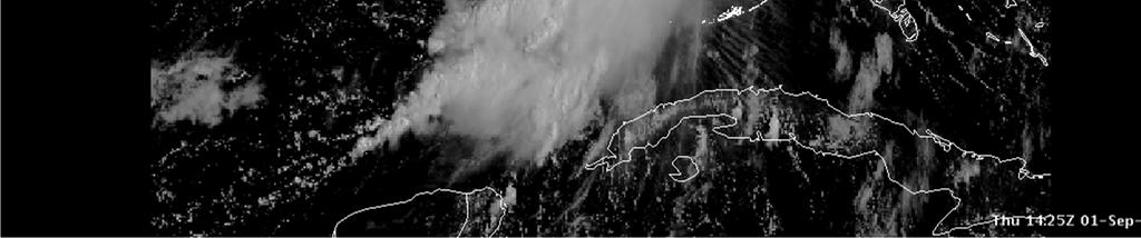
8 2016 Hermine Satellite Loop


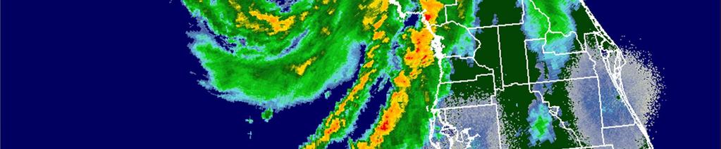
9 2016 Hermine Radar Loop


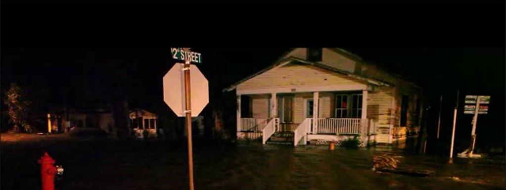
10 Hermine: Cedar Key Storm Surge
11 Cedar Key Surge Bar & Grill
12 2016 Major Hurricane Matthew
13 Hurricane Matthew Storm Surge Fort Pierce Beach Flagler Beach
14 Hurricane Matthew Storm Surge Saint Augustine Beach

15 The Power of Water Storm Surge creates a new inlet south of St Augustine Beach

16 Moving Water can be Deadly 3 ft 1 cubic yard of water weighs 1,700 pounds! 3 ft 3 ft


17 Before & After 2017 Hurricane Irma Key West Track of Irma


18 U.S. Hurricane Fatalities
 53%")

19 Florida Hurricane Fatalities Direct Fatalities Drowning (Coastal) 53% Florida numbers will be similar to the U.S. numbers when we get a major storm surge into a populated area
20 Question # 1 My comfort Level with evaluating local storm surge factors is? A. I am an expert in local storm surge B. I have a good comfort level with local surge C. I have some knowledge of local surge D. I m really not sure about local surge E. What is local storm surge and why am I here?
21 Storm Surge Vulnerability Vulnerability Map Almost 8 Million Floridians Live in Evacuation Zones A, B, and C
22 Question # 2 What best describes your personal responsibility with storm surge areas? A. My area is in a storm surge vulnerable area B. I have mutual aid responsibilities in surge areas C. I have personal property in surge areas D. I have no interest in surge areas E. I am checking /Facebook, stop bothering me!
23 Some Quick Definitions Astronomical Tide is the daily variation in sea level due to the gravitational influence of the Sun and Moon Storm Surge is an abnormal rise of water generated by a storm Storm Tide is the total water level that includes tide plus the storm surge
24 Fernandina Beach Tides September 11-12, 1964 Hurricane "Dora" Fernandina Beach Astronomical Tide 9/11-12/ hours :00:00 1:00 2:00 3:00 4:00 5:00 6:00 7:00 8:00 9:00 10:00 11:00 12:00 13:00 14:00 15:00 16:00 17:00 18:00 19:00 20:00 21:00 22:00 23:00 0:00:00 1:00 2:00 3:00 4:00 5:00 6:00 7:00 8:00 9:00 Friday, September 11, 1964 Saturday, September 12, 1964 Astro
25 Storm Surge, No Tide Hurricane "Dora" Fernandina Dora: Beach Storm 9/11-12/1964 Surge Almost 7 feet hours :00:00 1:00 2:00 3:00 4:00 5:00 6:00 7:00 8:00 9:00 10:00 11:00 12:00 13:00 14:00 15:00 16:00 17:00 18:00 19:00 20:00 21:00 22:00 23:00 0:00:00 1:00 2:00 3:00 4:00 5:00 6:00 7:00 8:00 9:00 Friday, September 11, 1964 Saturday, September 12, 1964 Surge
26 Tide Plus Storm Surge Hurricane "Dora" Fernandina Dora: Beach Storm 9/11-12/1964 Tide First Storm Tide 7 ft 12:30 pm Second Storm Tide 6.8 ft 11:30 pm Tide drops to 3.8 ft at 5 pm :00:00 1:00 2:00 3:00 4:00 5:00 6:00 7:00 8:00 9:00 10:00 11:00 12:00 13:00 14:00 15:00 16:00 17:00 18:00 19:00 20:00 21:00 22:00 23:00 0:00:00 1:00 2:00 3:00 4:00 5:00 6:00 7:00 8:00 9:00 Friday, September 11, 1964 Saturday, September 12, 1964 Storm Tide
27 Red Line = Light Blue + Blue Line Peak Storm Tide 7 hours before peak storm surge Storm Tide = Tide + Surge Hurricane "Dora" Fernandina Beach Total Tides 9/11-12/1964 Second Storm Tide 3 hours after peak storm surge :00:00 1:00 2:00 3:00 4:00 5:00 6:00 7:00 8:00 9:00 10:00 11:00 12:00 13:00 14:00 15:00 16:00 17:00 18:00 19:00 20:00 21:00 22:00 23:00 0:00:00 1:00 2:00 3:00 4:00 5:00 6:00 7:00 8:00 9:00 Friday, September 11, 1964 Saturday, September 12, 1964 Surge Astro Storm Tide
28 How We Build We Tend to Build to Our Normal Tidal ranges Brunswick, GA Sung Harbor, Toms River, NJ
29 How We Build Now Keaton Beach, FL Sung Harbor, Toms River, NJ
30 Some Tidal Ranges are Really Big Bay of Fundy, Canada Tidal Range 53 feet!
31 Question #3 The Daily/Diurnal Tidal Range at my local beach is? A. 1 to 2 feet B. 2 to 4 feet C. 4 to 6 feet D. 6 to 9 feet E. I haven t got a clue (but they serve Margaritas)!
32 Florida Tidal Range 0.9 ft September 10, ft 2.1 ft 4.3 ft 5.0 ft 3.0 ft Difference Between High and Low Tides 3.2 ft 2.1 ft 2.9 ft
33 Datums - This could be you! Your mayor ask you if the high school will flood if the storm surge hits at high tide? It s built in 1938 and historic with an elevation of +5 feet NGVD 1929 Your high tide that day is feet MLLW The surge is forecast to be +5 feet NAVD 1988 How much will the school flood Above Ground Level?
 Zero datum newer SLOSH basins Zero datum for Mean Sea Level Zero datum for many tide gauges Zero datum in older SLOSH basins AGL")
34 How High is 5 ft of Surge? At the Fort Myers - Caloosahatchee River 5 ft AGL is 5 ft AGL of surge 5 ft NAVD88 is 4 ft AGL of surge 5 ft NGVD29 is 2.84 ft AGL of surge 5 ft AGL 4 ft AGL 2.84 ft AGL Zero datum for Above Ground Level (I picked a random value) Zero datum newer SLOSH basins Zero datum for Mean Sea Level Zero datum for many tide gauges Zero datum in older SLOSH basins AGL NAVD88 MSL MLLW NGVD ft NAVD ft NAVD ft NAVD ft NAVD ft NAVD88
 when using or comparing water level data NAVD88")
35 Know Your Reference Level Be Wary of the Datum (reference level) when using or comparing water level data NAVD88 NGVD29
36 Question #4 The Datum I use most often and am comfortable with is? A. Mean Lower Low Water (MLLW) B. Mean Sea Level (MSL) C. Mean Higher High Water (MHHW) D. National Geodetic Vertical Datum 1929 (NGVD) E. North American Vertical Datum of 1988 (NAVD) F. What is the datum of which you speak????


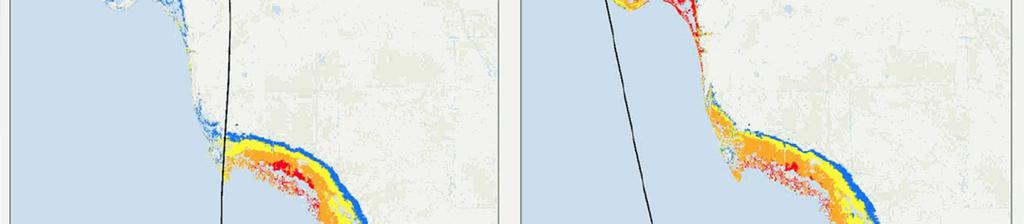
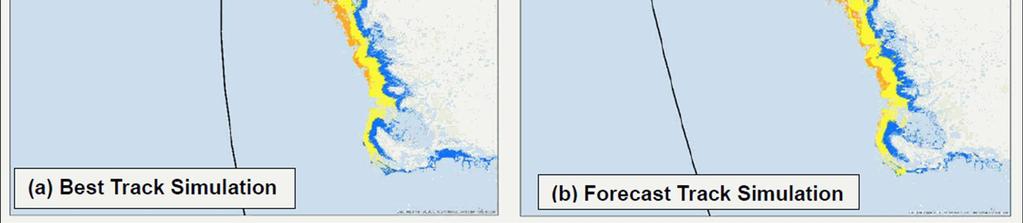
37 That is Why This Product Exists Potential Storm Surge Flooding Map Tool for evacuation decision making 9-in-10 times the surge will be lower than this

38 PSSF Map 2016 Hurricane Irma What does this map mean?
39 SW Florida Had 1-in-10 Chance of This 2008 Hurricane Ike, near Galveston, TX 2004 Hurricane Ivan, I-10, Pensacola, FL
40 Question #5 Topography vs Highest Surge? A. Convex B. Straight C. Concave D. Estuary
41 Some General Rules of Thumb Concave portions of a coast will USUALLY hold more storm surge/tide than convex portions of coast. All things being equal, a bay or estuary will experience higher storm surge/tide than a bulging coast or a point.
42 Concave and Convex Coast Biscayne Bay VS. South Beach Bathymetric Map 8 Feet 15 feet
43 A Tale of Two CAT 5s Concave Coast 33 feet Convex Coast 12 feet
44 More Rules of Thumb Larger storms affect longer stretches of coastline Direction of storm approach often impacts the extent of flooding Slope of the continental slope affects surge and waves Shallow slopes (West Florida) allow greater storm surge with small waves Steeper slopes (Miami area) have less surge but large breaking waves can occur
45 Size of Eye Wall Matters 12 mile wide eye wall 7 ft 2004 Hurricane Charley
46 What if Normal Size Eye? 50 mile wide eye wall 18 ft

47 Irma Storm Surge Simulations Feet Above MHHW Feet Above MHHW

48 More General Rules of Thumb Carter White Bay Shore Blvd in Tampa as 1985 Hurricane Elena stalled 100 miles to the northwest More intense storms cause higher surges Highest surges usually occur to the right of the storm track Fast moving storms = high surges along the open coast Slow moving storms = greater flooding inside bays and estuaries
49 2012 Tropical Storm Debby June 23-27, Peak wind 60 mph Debby made landfall at Steinhatchee, Florida with winds of 40 mph 9 Fatalities $309 million
50 Above Normal Tides 3.1 foot above normal at Clearwater Beach 4.07 foot above in Tampa Bay Tarpon Springs Joann Hoffman Clearwater Beach Rick Johnson Tampa Wen Dee
51 Above Normal Tides Around 4 foot above tide, Bay Shore Blvd in Tampa Road flooded for 2.5 days Tampa Dan Noah
52 Final Rules of Thumb Choke points MAY experience greater storm surge/tide than surrounding areas (e.g. rivers, canals, constricted channels) Inland bodies of water can experience a sloshing or sieche effect Lake Pontchartrain Lake Okeechobee St. Johns River
53 Jacksonville Choke Point 2017 Hurricane Irma flooding downtown was a combination of flooding from rain, surge, and tide Video Location


54 Monday, September 11, 2017 Tides around 4-5 feet above normal in Jacksonville Monday Morning
55 Question # 7 Inland bodies of water are immune from storm surge as they are not connected to the ocean! A. True B. False C. I m SOOOOOO confused!
56 Seiche Effect Cross Section of an Inland Water body
57 1949 Lake Okeechobee Hurricane
58 Around the Lake
59 1949 Lake Okeechobee Hurricane
60 1949 Lake Okeechobee Hurricane
61 Question # 8 Water flows fast so storm surge/tide is going to drop quickly at all points that it went to A.True B.False C.Really dude did you not see what happened in New Orleans!

62 Lake Pontchartrain 2012 Hurricane Isaac Flood Tide 5.5 days!


63 Note How Long It takes To Flush Water From Estuary! 4 Days 3 Days 2008 Hurricane Ike 2 Days
64 So How Did I Do? A. I really feel like I understand surge much better B. I feel like I understand surge a bit better C. Ok, I guess but I m still a somewhat confused D. Man, you kidding? You lost me on slide three E. Just wait until the evaluation dude! F. Man, I m still on Facebook! Leave me alone!


65 NWS Tropical Webpage What to Prepare For 1-in-10 chance Official Forecast 1-in-2 chance
66 Questions? NJ National Guard
Introduction to Storm Surge
 Introduction to Storm Surge Hurricane Katrina (2005) Mississippi 1200 deaths, $108 billion damage Hurricane Sandy (2012) Northeast U.S. 73 deaths, $65 billion damage Hurricane Ike (2008) - Bolivar Peninsula,
Boothbay Harbor Rotary Club May 12, 2016
 Mapping Potential Sea Level Rise and Storm Surge in Boothbay Harbor, ME Boothbay Harbor Rotary Club May 12, 2016 Peter A. Slovinsky, Marine Geologist Maine Geological Survey S.M. Dickson, MGS Quickly,
NYS Coastal Waters. Water Resources of NYS: THE NATURE of the COASTAL ZONE. NYS Coastal Waters. NYS Coastal Atlas. Coastal Zone Management 10/10/2014
 Water Resources of NYS: THE NATURE of the COASTAL ZONE NYS Coastal Waters NYS is the only state to border the Atlantic Ocean and the Great Lakes (Lakes Erie and Ontario). Great Lakes shoreline: 577 miles
UNDERSTANDING STORM SURGE
 The Education Program at the New Jersey Sea Grant Consortium 22 Magruder Road, Fort Hancock, NJ 07732 (732) 872-1300 www.njseagrant.org UNDERSTANDING STORM SURGE ACTIVITY 6 SURGE OF THE STORM http://secoora.org/classroom/virtual_hurricane/surge_of_the_storm>
Shorelines Earth - Chapter 20 Stan Hatfield Southwestern Illinois College
 Shorelines Earth - Chapter 20 Stan Hatfield Southwestern Illinois College The Shoreline A Dynamic Interface The shoreline is a dynamic interface (common boundary) among air, land, and the ocean. The shoreline
LOCAL COASTAL PROGRAM UPDATE
 LOCAL COASTAL PROGRAM UPDATE Agenda Meeting #1 General Information (1 1:45 pm) Introductions and Background Grants involved What is a Local Coastal Program? What is required? LCP Update tasks and schedule
SUPPLEMENTAL DOCUMENT SEA LEVEL RISE SCENARIO SELECTION AND DESIGN TIDE CALCULATION
 SUPPLEMENTAL DOCUMENT SEA LEVEL RISE SCENARIO SELECTION AND DESIGN TIDE CALCULATION FOR THE GUIDANCE FOR INCORPORATING SEA LEVEL RISE INTO CAPITAL PLANNING IN SAN FRANCISCO: ASSESSING VULNERABILITY AND
Texas passes, longshore transport, hurricanes, beach erosion and sea level
 Texas passes, longshore transport, hurricanes, beach erosion and sea level Richard L. Watson, Ph.D. (361) 749-4152 Field work can be strange! 120,000 years of sea level Years each zone exposed above S/L
SURGE SUPPRESSION ACHIEVED BY DIFFERENT COASTAL SPINE (IKE DIKE) ALIGNMENTS. Bruce A. Ebersole, Thomas W. Richardson and Robert W.
 ALIGNMENTS. Bruce A. Ebersole, Thomas W. Richardson and Robert W.") SURGE SUPPRESSION ACHIEVED BY DIFFERENT COASTAL SPINE (IKE DIKE) ALIGNMENTS Abstract Bruce A. Ebersole, Thomas W. Richardson and Robert W. Whalin, Jackson State University, Jackson, Mississippi The primary
SURGE SUPPRESSION ACHIEVED BY DIFFERENT COASTAL SPINE (IKE DIKE) ALIGNMENTS Abstract Bruce A. Ebersole, Thomas W. Richardson and Robert W. Whalin, Jackson State University, Jackson, Mississippi The primary
3/9/2013. Build house on cliff for a view of the ocean - be one with said view Pearson Education, Inc. Shorelines: summary in haiku form
 Introduction to Environmental Geology, 5e Edward A. Keller Shorelines: summary in haiku form Chapter 11 Coastal Processes Lecture Presentation prepared by X. Mara Chen, Salisbury University Build house
Chapter 20 Lecture. Earth: An Introduction to Physical Geology. Eleventh Edition. Shorelines. Tarbuck and Lutgens Pearson Education, Inc.
 Chapter 20 Lecture Earth: An Introduction to Physical Geology Eleventh Edition Shorelines Tarbuck and Lutgens The Shoreline: A Dynamic Interface The Coastal Zone The shoreline is constantly modified by
Under the Boardwalk: Coastal Geomorphology
 Under the Boardwalk: Coastal Geomorphology What to look for while you're on the beach during spring break. What Causes Changes in Sea Level? Answer Varies with Time Scale. Long-Term Changes in Sea Level
GEOLOGY 101 Under the Boardwalk: Coastal Geomorphology
 GEOLOGY 101 Under the Boardwalk: Coastal Geomorphology What to look for while you're on the beach during spring break. J.S. Kite, WVU What Causes Changes in Sea Level? Answer Varies with Time Scale. Long-Term
Coastal Inundation. An Overview for TCDC
 Coastal Inundation An Overview for TCDC Rick Liefting Team Leader Regional Hazards and Environmental Compliance Integrated Catchment Management Waikato Regional Council Photo: Sugar Loaf Wharf, Coromandel.
Chapter 15 SEASONAL CHANGES IN BEACHES OP THE NORTH ATLANTIC COAST OF THE UNITED STATES
 Chapter 15 SEASONAL CHANGES IN BEACHES OP THE NORTH ATLANTIC COAST OF THE UNITED STATES By John M. Darling Hydraulic Engineer, Research Division U. S. Army Coastal Engineering Research Center Corps of
Climate Change and Security:
 Climate Change and Security: Ideas & Inspiration from Annapolis Angela Schedel, CDR, U.S. Navy Assistant Professor, U.S. Naval Academy Presented on September 13, 2016 at USFSP icar Workshop Disclaimer
Tsunamis. Tsunamis COMMUNITY EMERGENCY RESPONSE TEAM TSUNAMIS
 Tsunamis Tsunamis Tell the participants that tsunamis are ocean waves that are produced by underwater earthquakes or landslides. The word is Japanese and means harbor wave because of the devastating effects
DELAWARE S VULNERABLE COASTAL AREAS. DELAWARE INLAND BAYS and DELAWARE BAY RECONNAISSANCE STUDY
 DELAWARE S VULNERABLE COASTAL AREAS and the DELAWARE INLAND BAYS and DELAWARE BAY RECONNAISSANCE STUDY Kimberly K. McKenna, PG Delaware Dept. of Natural Resources & Environmental Control Division of Watershed
Tides. Tides: longest waves. or seas. or ripples
 Tides or ripples or seas Tides: longest waves Tides Definition: The rise and fall of sea level due to the gravitational forces of the Moon and Sun and the rotation of the Earth. Why tides are important?
OCN 201 Tides. Tsunamis, Tides and other long waves
 OCN 201 Tides Tsunamis, Tides and other long waves Storm surges Caused by winds and low atmospheric pressure associated with large storms Can raise sea surface by up to 25 ft, bottom contours magnify effect
Hydrologic Feasibility of Storm Surge Barriers
 Hydrologic Feasibility of Storm Surge Barriers Malcolm J. Bowman, School of Marine and Atmospheric Sciences State University of New York, Stony Brook, NY. Presented at Against the Deluge: Storm Surge Barriers
COASTAL ENVIRONMENTS. 454 lecture 12
 COASTAL ENVIRONMENTS Repeated movement of sediment & water constructs a beach profile reflecting the balance between average daily or seasonal wave forces and resistance of landmass to wave action Coasts
Ivan-like hurricane storm surge simulations for Tampa Bay, FL with 3-D and 2-D models
 Ivan-like hurricane storm surge simulations for Tampa Bay, FL with 3-D and 2-D models R.H. Weisberg and L. Zheng Storm Surge Workshop St. Pete Beach 2/11/09 Potential for Tampa Bay area inundation is large
Hydrodynamic Modeling of Tides and Hurricane Storm Surge for Pre- and Post-Dredging Conditions in the Lower St. Johns River, Florida
 Hydrodynamic Modeling of Tides and Hurricane Storm Surge for Pre- and Post-Dredging Conditions in the Lower St. Johns River, Florida Matthew V. Bilskie 1 1 PhD Student, University of Central Florida, Department
Chapter - Oceans and Coasts
 Chapter - Oceans and Coasts Discussion: What do oceans contribute to the environment of Earth? How do Earth s major systems relate to the oceans? Oceans and Coasts Oceans are important - Thermal regulation
Announcements. Project 2 due Nov 7 th Topics for today: Big waves. Tsunamis, seiches and tidal waves. Tsunamis and seiches
 Announcements Project 2 due Nov 7 th Topics for today: Big waves Tsunamis, seiches and tidal waves Tsunamis and seiches Seiche: standing wave that rocks back and forth within an enclosed or semi-enclosed
4/20/17. #31 - Coastal Erosion. Coastal Erosion - Overview
 Writing Assignment Due Monday by 11:59 pm #31 - Coastal Erosion Beach front property! Great View! Buy now at a great price! See main class web pages for detailed instructions Essays will be submitted in
Beach Renourishment in Jacksonville
 Beach Renourishment in Jacksonville Kevin Bodge, PhD, P.E. - Olsen Associates, Inc. 1978 Oct 2004 2000 2016 2011 Oct 2016 Coastal Duval County, FL Nassau Sound Blount Island Ft. George Inlet St. Johns
CALCASIEU SALINITY STRUCTURES. HYDRODYNAMIC MODELING (To Support Design of Salinity Barriers)
") CALCASIEU SALINITY STRUCTURES HYDRODYNAMIC MODELING (To Support Design of Salinity Barriers) Presentation Overview 1 2 3 4 5 Project Overview and CEA Circulation Modeling Vessel Hydrodynamics Modeling
CALCASIEU SALINITY STRUCTURES HYDRODYNAMIC MODELING (To Support Design of Salinity Barriers) Presentation Overview 1 2 3 4 5 Project Overview and CEA Circulation Modeling Vessel Hydrodynamics Modeling
Tides Unit III: Real Tides (2 pts)
") T. James Noyes, El Camino College Tides Unit III: Real Tides (Topic 7A-3) page 1 Name: Section: Tides Unit III: Real Tides (2 pts) Real Tides Real tides can differ significantly from the predictions of
T. James Noyes, El Camino College Tides Unit III: Real Tides (Topic 7A-3) page 1 Name: Section: Tides Unit III: Real Tides (2 pts) Real Tides Real tides can differ significantly from the predictions of
Coastal management has lagged behind the growth in population leading to problems with pollution
 Fifty percent of the population of the industrialized world lives within 100 km of a coast. Coastal management has lagged behind the growth in population leading to problems with pollution and natural
Overview and preview. I. Tides as Waves (really really big) What are the Forces driving these waves? II: Into make-believe.
 What are the Forces driving these waves? II: Into make-believe.") The Tides Overview and preview I. Tides as Waves (really really big) What are the Forces driving these waves? II: Into make-believe. Idealized world: no land, deep water, no friction.no problems. Effects
The Tides Overview and preview I. Tides as Waves (really really big) What are the Forces driving these waves? II: Into make-believe. Idealized world: no land, deep water, no friction.no problems. Effects
2013 FEDERAL STORM RESPONSE
 2013 FEDERAL STORM Presented to the Florida Shore & Beach Association Sep 26, 2013 Presented by: COL Alan Dodd Commander, Jacksonville District September 2013 THE COLLABORATION 2 THE PROGRAM 3 THE STORMS
Sea Level Rise and Coastal Flooding Why Waves Matter!
 Sea Level Rise and Coastal Flooding Why Waves Matter! Jason D. Burtner Massachusetts Office of Coastal Zone Management South Shore Regional Coordinator Sea Level Rise and Coastal Storm Damage and Flooding
APPENDIX C. Fluvial and Tidal Hydraulics Report
 APPENDIX C Fluvial and Tidal Hydraulics Report BUENA VISTA LAGOON ENHANCEMENT PROJECT FLUVIAL AND TIDAL HYDRAULICS ANALYSES Prepared for: SANDAG 401 B Street, Suite 800 San Diego, California 92101 Contact:
Marginal Marine Environments
 Marginal Marine Environments Delta: discrete shoreline protuberances formed where rivers enter oceans, semi-enclosed seas, lakes or lagoons and supply sediment more rapidly than it can be redistributed
Unit 11 Lesson 2 How Does Ocean Water Move? Copyright Houghton Mifflin Harcourt Publishing Company
 Unit 11 Lesson 2 How Does Ocean Water Move? Catch a Wave A wave is the up-and-down movement of surface water. Catch a Wave Catch a Wave (wave effects) Surface waves are caused by wind pushing against
page - Laboratory Exercise #5 Shoreline Processes
 page - Laboratory Exercise #5 Shoreline Processes Section A Shoreline Processes: Overview of Waves The ocean s surface is influenced by three types of motion (waves, tides and surface currents). Shorelines
FOR PERSONAL USE. Shoreline Erosion BROWARD COUNTY ELEMENTARY SCIENCE BENCHMARK PLAN ACTIVITY ASSESSMENT OPPORTUNITIES. Grade 4 Quarter 1 Activity 9
 activity 9 Shoreline Erosion BROWARD COUNTY ELEMENTARY SCIENCE BENCHMARK PLAN Grade 4 Quarter 1 Activity 9 SC.D.1.2.4 The student knows that the surface of the Earth is in a continuous state of change
Chapter 10 Lecture Outline. The Restless Oceans
 Chapter 10 Lecture Outline The Restless Oceans Focus Question 10.1 How does the Coriolis effect influence ocean currents? The Ocean s Surface Circulation Ocean currents Masses of water that flow from one
Beach Nourishment Impact on Beach Safety and Surfing in the North Reach of Brevard County, Florida
 Beach Nourishment Impact on Beach Safety and Surfing in the North Reach of Brevard County, Florida Prepared by John Hearin, Ph.D. Coastal Engineering Vice Chairman Cocoa Beach Chapter Port Canaveral Patrick
Evaluation of June 9, 2014 Federal Emergency Management Agency Flood Insurance Study for Town of Weymouth, Norfolk, Co, MA
 Evaluation of June 9, 2014 Federal Emergency Management Agency Flood Insurance Study for Town of Weymouth, Norfolk, Co, MA Prepared For: Woodard & Curran 95 Cedar Street, Suite 100 Providence, RI 02903
OECS Regional Engineering Workshop September 29 October 3, 2014
 B E A C H E S. M A R I N A S. D E S I G N. C O N S T R U C T I O N. OECS Regional Engineering Workshop September 29 October 3, 2014 Coastal Erosion and Sea Defense: Introduction to Coastal Dynamics David
Fishing Pier Design Guidance. Part 1: Historical Pier Damage in Florida
 Fishing Pier Design Guidance Part 1: Historical Pier Damage in Florida Ralph R. Clark Florida Department of Environmental Protection Bureau of Beaches and Coastal Systems May 2010 Table of Contents Foreword...
Figure 4, Photo mosaic taken on February 14 about an hour before sunset near low tide.
 The Impact on Great South Bay of the Breach at Old Inlet Charles N. Flagg and Roger Flood School of Marine and Atmospheric Sciences, Stony Brook University Since the last report was issued on January 31
Oceans in Motion: Waves and Tides
 Oceans in Motion: Waves and Tides Waves Waves are among the most familiar features in the ocean. All waves work similarly, so although we are talking about ocean waves here, the same information would
CHAPTER 281 INFLUENCE OF NEARSHORE HARDBOTTOM ON REGIONAL SEDIMENT TRANSPORT
 CHAPTER 281 INFLUENCE OF NEARSHORE HARDBOTTOM ON REGIONAL SEDIMENT TRANSPORT Paul C.-P. Lin, Ph.D., P.E. 1 and R. Harvey Sasso, P.E. 2 ABSTRACT The influence of nearshore hardbottom on longshore and cross-shore
Intracoastal Waterway and other Federal Shallow Draft Inlets
 Intracoastal Waterway and other Federal Shallow Draft Inlets Shelley Trulock Project Manager 904-232-3292 Navigation 900 miles of Inland Waterways 6 navigation locks Atlantic Intracoastal Waterway (AIWW)
Shore - place where ocean meets land Coast - refers to the larger zone affected by the processes that occur at this boundary.
 Waves, Beaches, and Coasts Shore - place where ocean meets land Coast - refers to the larger zone affected by the processes that occur at this boundary. Waves: energy moving through water The height of
WIND SPEED LENGTH OF TIME WIND BLOWS (Duration) DISTANCE OVER WHICH IT BLOWS (Fetch)
 DISTANCE OVER WHICH IT BLOWS (Fetch)") WAVES Up and down movement of ocean surface Transportation of energy across the water over vast distances If not stopped by anything, waves can travel entire oceans Size and speed depend upon: WIND SPEED
WAVES Up and down movement of ocean surface Transportation of energy across the water over vast distances If not stopped by anything, waves can travel entire oceans Size and speed depend upon: WIND SPEED
Lecture Outlines PowerPoint. Chapter 15 Earth Science, 12e Tarbuck/Lutgens
 Lecture Outlines PowerPoint Chapter 15 Earth Science, 12e Tarbuck/Lutgens 2009 Pearson Prentice Hall This work is protected by United States copyright laws and is provided solely for the use of instructors
Prof. B.S. Thandaveswara. The periodic rise and fall of the planetary ocean level in response to the gravitational
 37.5 Tides The periodic rise and fall of the planetary ocean level in response to the gravitational interaction of the earth, moon, and sun. The periodic rise and fall of sea level that results from the
2016 NC Coastal Local Governments Annual Meeting
 2016 NC Coastal Local Governments Annual Meeting Coastal Flood Study Modeling and Mapping 101 April 21, 2016 Tom Langan, PE, CFM Engineering Supervisor NCEM Floodplain Mapping Program FEMA Coastal Flood
The ocean water is dynamic. Its physical
 CHAPTER MOVEMENTS OF OCEAN WATER The ocean water is dynamic. Its physical characteristics like temperature, salinity, density and the external forces like of the sun, moon and the winds influence the movement
APPENDIX D-2. Sea Level Rise Technical Memo
 APPENDIX D-2 Sea Level Rise Technical Memo 2185 N. California Blvd., Suite 500 Walnut Creek, CA 94596 (925) 944-5411 Fax: (925) 944-4732 www.moffattnichol.com DRAFT MEMORANDUM To: From: Neil Nichols,
Volume and Shoreline Changes along Pinellas County Beaches during Tropical Storm Debby
 Volume and Shoreline Changes along Pinellas County Beaches during Tropical Storm Debby Ping Wang and Tiffany M. Roberts Coastal Research Laboratory University of South Florida July 24, 2012 Introduction
G. Meadows, H. Purcell and L. Meadows University of Michigan
 www.coj.net/departments/fire+and+rescue/emergency+preparedness/rip+current.htm G. Meadows, H. Purcell and L. Meadows Over 80% of all surf related rescues are attributable to Rip Currents According to the
consulting engineers and scientists
 consulting engineers and scientists Coastal Processes Presented by: January 9, 2015 Varoujan Hagopian, P.E. F.ASCE Senior Consultant, Waterfront Engineer Living Shoreline Workshop Lets Remember Why We
US Beach Nourishment Experience:
 Beach Nourishment: Introduction of new sand to the beach by truck or dredge Large beach >1 million cubic yards (100,000 dump truck loads) Funding is a combination of federal, state, local & private Also
FLORIDA DEPARTMENT OF ENVIRONMENTAL PROTECTION
 ORIDA DEPARTMENT OF ENVIRONMENTAL PROTECTION MARJORY STONEMAN DOUGLAS BUILDING 3900 COMMONWEALTH BOULEVARD TALLAHASSEE, ORIDA 32399-3000 RICK SCOTT GOVERNOR CARLOS LOPEZ-CANTERA LT. GOVERNOR HERSCHEL T.
SURFACE CURRENTS AND TIDES
 NAME SURFACE CURRENTS AND TIDES I. Origin of surface currents Surface currents arise due to the interaction of the prevailing wis a the ocean surface. Hence the surface wi pattern (Figure 1) plays a key
Oceans and Coasts. Chapter 18
 Oceans and Coasts Chapter 18 Exploring the oceans The ocean floor Sediments thicken and the age of the seafloor increases from ridge to shore The continental shelf off the northeast United States Constituent
Chapter 11 Tides. A tidal bore is formed when a tide arrives to an enclosed river mouth. This is a forced wave that breaks.
 Chapter 11 Tides A tidal bore is formed when a tide arrives to an enclosed river mouth. This is a forced wave that breaks. Tidal range can be very large Tide - rhythmic oscillation of the ocean surface
Coastal Environments Oceanographic and Engineering Expertise
 Coastal Environments Oceanographic and Engineering Expertise Coastal Environments La Jolla, CA www.coastalenvironments.com 14 May 2004 CE Ref. No. 04-05 EcoSystems Management Associates, Inc. Carlsbad,
Environmental Geology Chapter 11 COASTAL PROCESSES and RELATED HAZARDS
 Environmental Geology Chapter 11 COASTAL PROCESSES and RELATED HAZARDS Introduction >50% of world population concentrated in the coastal zones ~75% of U.S. population living in coastal states Coastal hazard
Questions # 4 7 refer to Figure # 2 (page 321, Fig )
") Shoreline Community College OCEANOGRAPHY 101 Fall 2006 Sample Exam # 3 Instructor: Linda Khandro Questions # 1 3 refer to Figure # 1 (page 284, Fig 11.7) 1. At which position is the moon in its new moon
Shoreline Community College OCEANOGRAPHY 101 Fall 2006 Sample Exam # 3 Instructor: Linda Khandro Questions # 1 3 refer to Figure # 1 (page 284, Fig 11.7) 1. At which position is the moon in its new moon
MEAN LOW TIDE (MLT) to MEAN LOWER LOW WATER (MLLW)
 to MEAN LOWER LOW WATER (MLLW)") MEAN LOW TIDE (MLT) to MEAN LOWER LOW WATER (MLLW) WEDA GULF COAST CHAPTER ANNUAL CONFERENCE Christopher Frabotta Deputy Chief, Operations Division Galveston District Southwestern Division November 16,
MEAN LOW TIDE (MLT) to MEAN LOWER LOW WATER (MLLW) WEDA GULF COAST CHAPTER ANNUAL CONFERENCE Christopher Frabotta Deputy Chief, Operations Division Galveston District Southwestern Division November 16,
Storm Induced Beach Profile Changes along the Coast of Treasure Island, West-Central Florida, U.S.A.
 University of South Florida Scholar Commons Graduate Theses and Dissertations Graduate School 11-21-2016 Storm Induced Beach Profile Changes along the Coast of Treasure Island, West-Central Florida, U.S.A.
TIDES. Theory and Application
 TIDES Theory and Application Tidal Concepts Tides are extremely swift, very long-wavelength, shallow-water waves Tides are periodic short-term changes in sea level at a particular place caused by the gravitational
Sussex County, DE Preliminary Study Overview
 Sussex County, DE Preliminary Study Overview Coastal study scope: 102 miles of entire County shoreline Revised 102 panels for coastal study Riverine study scope: 14 streams, 67.1 miles, within the Nanticoke
The Ike Dike. A Coastal Barrier Protecting the. Hurricane Storm Surge. Protecting the Houston/Galveston Region from Hurricane Storm Surge
 The Ike Dike A Coastal Barrier Protecting the Houston/Galveston A Coastal Barrier Region from Hurricane Storm Surge Protecting the Houston/Galveston Region from Hurricane Storm Surge The Houston/Galveston
THE OCEAN IS ALWAYS IN MOTION. WHY IS THIS IMPORTANT? First we need to know what kinds of movement there are in the ocean. Three Kinds of Water
 The meeting of two plates sometimes makes it possible for water to enter the area as happens with the Red Sea, which was formed when the Arabian peninsula was split from the Horn of Africa but the Red
Vocabulary: Headwaters, watershed, tributaries, estuary, replica, point source pollution, nonpoint source pollution, amd river miles.
 From Source To Sea: Lesson Plan Concepts: 1. Understanding the path the Hudson River takes from the headwaters in the Adirondacks to the New York Harbor 2. Identifying the Hudson River watershed area,
VENICE LOCAL COASTAL PROGRAM UPDATE: COASTAL HAZARDS WELCOME
 VENICE LOCAL COASTAL PROGRAM UPDATE: COASTAL HAZARDS WELCOME 1 Introducing the Team Hosted by the Department of City Planning and grant funded in part by the California Coastal Commission 2 Workshop Purpose
Whether or not the whirlpool appears and how rapidly it spins are a function of the tides. High tides and especially spring tides produce the most
 Whirlpools In addition, the changing of the tides can create another hazard known as a whirlpool. These are created when the water from two opposing currents meet and form a vortex. (This is NOT what happens
Welcome to Flagler Beach, Florida!
 Welcome to Flagler Beach, Florida! Ocean Front Property Now Available Page 2: Location Overview Page 3: Map and Near-by Florida Attractions Page 4: Slow Down and Take A Look Page 5: Highlights Page 6:
Cyclone Hazards: waves and storm tide
 Cyclone Hazards: waves and storm tide 1/32 HIGH WAVES TORRENTIAL RAIN (FLOODING) SURGE ON COAST AT CROSSING GALE FORCE WINDS 2/32 Waves and Swell MetEd Comet Program Wind and Wave forecasting https://www.meted.ucar.edu/training_course.php?id=8
If you have a badge logo I d center it to this text. Douglas F. Jackson. Fire Chief / Emergency Management Director East Haven, CT
 If you have a badge logo I d center it to this text Douglas F. Jackson Fire Chief / Emergency Management Director East Haven, CT Experience 9YEARS Experience as Fire Chief Emergency Management Director
Bathymetry Data Collection for Subaqueous Soil Mapping. Maggie Payne 2 nd National Workshop on Subaqueous Soils Rhode Island August 9-12, 2010
 Bathymetry Data Collection for Subaqueous Soil Mapping Maggie Payne 2 nd National Workshop on Subaqueous Soils Rhode Island August 9-12, 2010 Overview of Method Collect tide data Collect bathymetry data
Coastal Hazards Study
 Coastal Hazards Study 2212 Beach Boulevard, Pacifica Prepared for: EXECUTIVE SUMMARY City of Pacifica 170 Santa Maria Ave Pacifica, CA 94044 Prepared by: moffatt & nichol 2185 N. California Blvd. Walnut
STATUS REPORT FOR THE SUBMERGED REEF BALL TM ARTIFICIAL REEF SUBMERGED BREAKWATER BEACH STABILIZATION PROJECT FOR THE GRAND CAYMAN MARRIOTT HOTEL
 August 23 STATUS REPORT FOR THE SUBMERGED REEF BALL TM ARTIFICIAL REEF SUBMERGED BREAKWATER BEACH STABILIZATION PROJECT FOR THE GRAND CAYMAN MARRIOTT HOTEL performed by Lee E. Harris, Ph.D., P.E. Consulting
LEARNING FROM SANDY Webinar 2. Lessons learned. March 12, Beth A. Leonard Director of Technical Services BoatU.S.
 LEARNING FROM SANDY Webinar 2 Lessons learned March 12, 2013 Beth A. Leonard Director of Technical Services BoatU.S. Association of Marina Industries (AMI) Website: http://marinaassociation.org/ Contact:
4/20/17. #32 - Coastal Erosion Case Histories - Lake Michigan
 Writing Assignment Due Monday by 11:59 pm #32 - Coastal Erosion Case Histories - Lake Michigan See main class web pages for detailed instructions Submit papers Illinois Compass No copying: Compass will
Shorelines Earth Chapter 20 Chapter 20 Shorelines The Shoreline: A Dynamic Interface Cape Cod and Point Reyes Hurricane Sandy
 1 2 3 4 5 6 7 8 9 10 11 12 13 Shorelines Earth Chapter 20 Chapter 20 Shorelines The Shoreline: A Dynamic Interface The interface is the common boundary where different parts of a system interact. The Coastal
Theory and Application Introductory Oceanography Ray Rector: Instructor
 OCEAN TIDES Theory and Application Introductory Oceanography Ray Rector: Instructor Tidal Concepts Tides are extremely swift, very long-wavelength, shallow-water waves Tides are periodic short-term changes
Reading Material. Inshore oceanography, Anikouchine and Sternberg The World Ocean, Prentice-Hall
 Reading Material Inshore oceanography, Anikouchine and Sternberg The World Ocean, Prentice-Hall BEACH PROCESSES AND COASTAL ENVIRONMENTS COASTAL FEATURES Cross section Map view Terminology for Coastal
Post Hurricane-Irma ecological assessments
 Post Hurricane-Irma ecological assessments Nicholas G. Aumen US Geological Survey On behalf of many scientists April 25, 2018 Caveats and comments The Science Coordination Group sponsored a meeting on
EVALUATION OF BEACH EROSION UP-DRIFT OF TIDAL INLETS IN SOUTHWEST AND CENTRAL FLORIDA, USA. Mohamed A. Dabees 1 and Brett D.
 EVALUATION OF BEACH EROSION UP-DRIFT OF TIDAL INLETS IN SOUTHWEST AND CENTRAL FLORIDA, USA Mohamed A. Dabees 1 and Brett D. Moore 1 The paper discusses the analysis of up-drift beach erosion near selected
MAR 555 Lecture 20: Coastal Tides
 MAR 555 Lecture 20: Coastal Tides Tides caused by the resulting gravitational and centrifugal forces is called equilibrium tide. They can be expressed using the harmonic functions as N semi! e(semi) =
Physical Geography. Physical Geography III of the United States and Canada. Formation of Great Lakes. Climates of North America. Definitions 2/21/2013
 Physical Geography III of the United States and Canada Ancient Glacial Lakes As the Ice Age ended, areas of North America beyond the terminal moraine were flooded with melt water Prof Anthony Grande AFG
Controlling Coastal erosion
 Controlling Coastal erosion Coastal Erosion Rates in the U.S. Coastal Erosion and Stabilization Economic pressures demanding the stabilization of beaches and coastlines are immense Coastal Erosion and
Understanding the Tsunami Wave
 The First Tsunami attack on Sri Lanka Krakatoa Island 27 th August 1883 Understanding the Tsunami Wave Generation Propagation Nearshore Transformation Shoreline Entry Inland Dissipation 1 Generation and
LAB: WHERE S THE BEACH
 Name: LAB: WHERE S THE BEACH Introduction When you build a sandcastle on the beach, you don't expect it to last forever. You spread out your towel to sunbathe, but you know you can't stay in the same spot
APPENDIX A APPENDIX B APPENDIX C APPENDIX D APPENDIX E APPENDIX F APPENDIX G SEDIMENT ANALYSIS APPENDIX A WAVE & SEDIMENT MODELS CRYSTAL BALL ANALYSIS
 APPENDIX A WAVE & SEDIMENT MODELS APPENDIX B SEDIMENT ANALYSIS APPENDIX A WAVE & SEDIMENT MODELS APPENDIX C CRYSTAL BALL ANALYSIS APPENDIX D SBEACH ANALYSIS APPENDIX E GENESIS ANALYSIS APPENDIX F PREFERRED
4/06/2014. Need for Guidance. East Coast Lows. Catchment and coastal flood events can combine! Project 18 ARR Review
 Need for Guidance Development of Practical Guidance for Coincidence of Catchment Flooding and Oceanic Inundation Angela Toniato, NSW OEH Duncan McLuckie, NSW OEH Grantley Smith, Water Research Laboratory
City of Del Mar Local Coastal Plan (LCP) Amendment for Sea Level Rise and Coastal Flooding
 Amendment for Sea Level Rise and Coastal Flooding") City of Del Mar Local Coastal Plan (LCP) Amendment for Sea Level Rise and Coastal Flooding 6/22/17 Presentation to Sea Level Rise Stakeholder- Technical Advisory Committee (STAC) Nick Garrity, P.E. Lindsey
City of Del Mar Local Coastal Plan (LCP) Amendment for Sea Level Rise and Coastal Flooding 6/22/17 Presentation to Sea Level Rise Stakeholder- Technical Advisory Committee (STAC) Nick Garrity, P.E. Lindsey
Tidal Hydrology, Hydraulics and Scour at Bridges First Edition
 Publication No. FHWA-NHI -05-077 December 2004 Hydraulic Engineering Circular No. 25 Tidal Hydrology, Hydraulics and Scour at Bridges First Edition 1. Report No. FHWA NHI HEC-25 4. Title and Subtitle
INTRODUCTION TO COASTAL ENGINEERING
 The University of the West Indies Organization of American States PROFESSIONAL DEVELOPMENT PROGRAMME: COASTAL INFRASTRUCTURE DESIGN, CONSTRUCTION AND MAINTENANCE A COURSE IN COASTAL DEFENSE SYSTEMS I CHAPTER
Directed Reading. Section: Ocean Currents. a(n). FACTORS THAT AFFECT SURFACE CURRENTS
. FACTORS THAT AFFECT SURFACE CURRENTS") Skills Worksheet Directed Reading Section: Ocean Currents 1. A horizontal movement of water in a well-defined pattern is called a(n). 2. What are two ways that oceanographers identify ocean currents? 3.
Skills Worksheet Directed Reading Section: Ocean Currents 1. A horizontal movement of water in a well-defined pattern is called a(n). 2. What are two ways that oceanographers identify ocean currents? 3.
Synoptic Lab, MET 421, Test 2
 Name Synoptic Lab, MET 421, Test 2 1) For a 15 ms -1 east wind blowing towards Milwaukee a) Calculate the distance to the east shore of Lake Michigan. You can use a distance calculator website such as