Good swimming. Watch for turtles. Boats with electric motors permitted. Stocked with Cutthroat and Rainbow trout. Bring a blanket for the beach.
|
|
|
- Jordan Fowler
- 5 years ago
- Views:
Transcription
1
2 Matheson Lake At over 160 hectares, Matheson Lake Regional Park offers just about anything a person could want from a lake. A sand beach, hiking trails, and direct access from the Galloping Goose Regional Trail make Matheson a favourite for families and cyclists. FACTS Surface Area 25 ha METCHOSIN Max Depth Elevation Land Status 5 m 21 m Regional Park ACTIVITIES Swimming Hiking Cycling Boating Fishing Picnics Good swimming. Watch for turtles. Trail circling the lake provides a good workout. The north east side is flat and easy, while the south west side is moderate to challenging. Access from the Galloping Goose Regional Trail. Cycling not permitted in the park. Boats with electric motors permitted. Stocked with Cutthroat and Rainbow trout. Bring a blanket for the beach. FACILITIES Pets Must be under control and on trails. Must be on a leash at the main beach from June 1 to Sept 15. Beach Washrooms Accessibility Large sandy beach close to the parking lot. Available close to the main beach. The short trail to the beach may not be wheelchair accessible. The near by Galloping Goose Regional Trail offers a wheelchair accessible stroll, but does not provide lake views. METCHOSIN 105

3 Swimmers on Ian Gillespie Island at Matheson Lake. Photo by Adam Ungstad. DIRECTIONS FROM VICTORIA 1. Head north on Douglas St (Trans-Canada Hwy) 2. Take Exit 10 toward View Royal/Colwood 3. Slight right onto Island Hwy S 4. Continue onto Old Island Hwy S 5. Continue onto Sooke Rd S 6. Turn left onto Metchosin Rd 7. Turn right onto Happy Valley Rd 8. Take the 1st left onto Rocky Point Rd 9. Turn right onto Matheson Lake Park Rd 106 SECR ET L A K ES OF S OU TH ER N VA NC OU VE R I S LA N D
4
5 Referred to as a precious jewel in a 1979 edition of the Victoria Times, Matheson Lake is a wonderful place with a sand beach, surrounding mid-growth forest, and plenty of trails to explore nearby. It will take several visits to truly know the nature of this magical place. If you prefer being in the water rather than on the trails, swim from the main beach out to Ian Gillespie Island. This small island offers plenty of space to lie down and soak up the sun after a good swim. While you are there be sure to say a friendly hello to the colony of peaceful ants that calls the island home. Leading through Douglas fir, arbutus, and western red cedar woods, the full lakeside trail takes about 2-3 hours. It connects with the Galloping Goose Regional Trail and crosses Wildwood Creek before taking an incline up Mount Matheson on the south side. Watch for yellow skunk cabbage at the west end of the lake as well as chikadees, woodpeckers, and Steller s jay in the branches around you. METCHOSIN If you decide to hike the full trail, keep in mind that maps can be deceiving and that the south side of the lake requires a bit of endurance. If you venture to the south side be sure to wear better shoes than flip flops! The views of the lake make this effort worthwhile. Matheson Lake is a local favourite for fishing, either from the shore, a boat, or a float tube. The lake is stocked with cutthroat and rainbow trout, and the fishing is best in April and May. If you don t mind carrying your boat about 300 meters from the car park it s possible to launch small boats from the main beach area. Boats with electric motors are permitted. HISTORY Matheson Lake and its neighbour, the 700 foot Mount Matheson, were named after Sir James Matheson, a prominent business man in Hong Kong in the early 1800s. It is not clear whether James Matheson ever visited the area. The lake was originally referred to as Big Lake in an early Victoria Directory, and was also known as Ash s Lake after Dr. John Ash who owned land in the area. Before the Galloping Goose Railway was converted to a trail, the residents of Sooke would pack a lunch and walk along the rail line to Matheson Lake, making it an all-day outing. Many of them would return home at the end of the day with plenty of fish. Did you know? Aboriginal lore recounted by Chief Ed Underwood of the East Saanich First Nations band states that Matheson Lake is guarded by all-powerful giants called Sheyeyas. Superior in intelligence and larger than sasquatches, Sheyeyas are invisible and can take on any shape they wish. It is believed that the Sheyeyas took the shapes of swans to guard the lake in the past. METCHOSIN 107

6 A glimpse of Matheson Lake through the trees on the lakeshore trail. Photo by Adam Ungstad. SECR ET L A K ES OF S OU TH ER N VA NC OU VE R I S LA N D
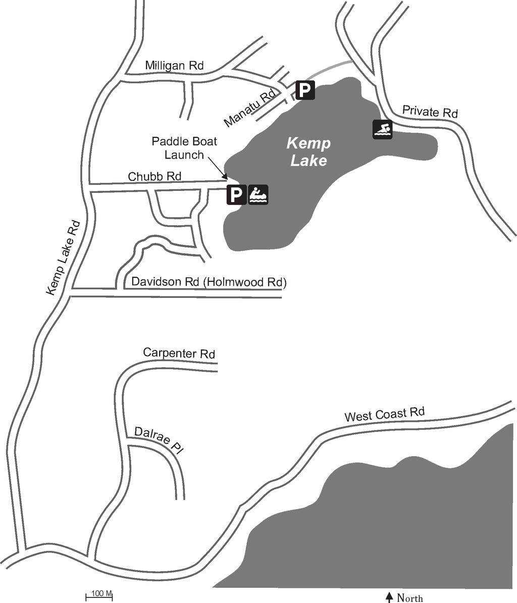
7 Kemp Lake Found just past the municipality of Sooke, Kemp Lake is ideal for canoes and kayaks. Bring a picnic lunch to watch dragonflies circle water lilies. Aside from being a beautiful place to visit, the lake serves as a water source for the community living nearby. FACTS SOOKE Surface Area Max Depth Elevation Land Status 25 ha 11 m 33 m Private Land / Municipal Access Points ACTIVITIES Swimming Hiking Boating Fishing Picnics Pets Good swimming. Watch for turtles. A network of trails exists on the east side of the lake (Broom Hill). These trails are on private land. Carry-in boat launch at Chubb Rd. Power boats not permitted. Cutthroat and rainbow trout (stocked in 2012). The best place for a picnic at Kemp Lake is on your canoe. Must be under control and kept on trails. FACILITIES Beach Washrooms Accessibility A sand beach can be found at the north-east corner of the lake. The beach is accessible only by canoe or paddle boat however, as the beach is not on public land. None. Chubb Rd provides an easy point to view the lake. SOOKE 119

8 A beach on the north-east side of the lake offers a great place for paddlers to stop for a picnic. Photo by Adam Ungstad. DIRECTIONS FROM VICTORIA 1. Head north on Douglas St (Trans-Canada Hwy) 2. Take Exit 14 toward Langford/Sooke/Highlands 3. Keep left at the fork, follow signs for McCallum Road W 4. Merge onto Millstream Rd S 5. Millstream Rd S turns into Veterans Memorial Pkwy 6. Turn right onto Sooke Rd 7. Follow Sooke Rd past the town of Sooke 8. Turn right onto Kemp Lake Rd 9. Turn right onto Chubb Rd 120 SECR ET L A K ES OF S OU TH ER N VA NC OU VE R I S LA N D
9
10 If you are coming from the city the first thing you will notice getting out of your vehicle at Kemp Lake is the pristine, fresh ocean air in the Sooke area the air at Kemp Lake alone will make your trip worthwhile! Located just beyond the municipality of Sooke, this beautiful body of water is particularly well suited for non-motorized boats such as canoes, kayaks, and other rowboats. The boat launch and main access point is located off Chubb Road. Take a picnic lunch and watch for wildlife, dragonflies, and water lilies on the surface of the lake. The east side of the lake, known as Broom Hill is currently private land, but local advocates are working to have the area become a park. And so they should the network of trails in the area is an asset to the community. SOOKE A unique feature of Kemp Lake is that it is an active water source for approximately 750 people that live in the area. The Kemp Lake Waterworks District is managed by three elected trustees, with a new trustee being elected each year for a three year term. SOOKE 121

11 Thanks for reading! This has been a sample of secret lakes of southern vancouver island The full guidebook covers 25 lakes in victoria, sooke and saanich! get your copy:
Macutagon Creek to Russell s Landing
 Day Trips Macutagon Creek to Russell s Landing Manitouwadge Public Consultation Committee Canoe Route #13 #13 MACUTAGON CREEK TO RUSSELL S LANDING This route is suitable to all levels of paddlers but due
2010 Kemp Lake Angling and Lake Infrastructure Improvement Proposal
 2010 Kemp Lake Angling and Lake Infrastructure Improvement Proposal Prepared for: Capital Regional District Juan de Fuca Electoral Area Community Parks and Recreation #2-6868 West Coast Road P.O. Box 283,
*Sandy Point State Park Paddling Routes
 *Sandy Point State Park Paddling Routes *Paddleboards are crazy popular in Anne Arundel County creeks and rivers. The life guards on this park s beaches have paddleboards to use in recusing swimmers. Not
Canoe/Kayak Launch Sites and Accessibility
 Canoe/Kayak Launch Sites and Accessibility Doug Alderson, Paddling Trails Coordinator Division of Recreation and Parks Office of Greenways and Trails Each potential access site on a river, lake or ocean
Floating the Buffalo National River. with First River Outfitter. Michelle Hulett. exp2010_w01h3buffalo2_ann_solution
 Floating the Buffalo National River with First River Outfitter Michelle Hulett The Buffalo River Beginning as just a trickle, The Buffalo National River runs down the Boston Mountains, flows north and
In South Walton County, on the choctawhatchee bay...
 In South Walton County, on the choctawhatchee bay... Surrounded by water and within minutes of Emerald Coast beaches. Live Oak Landing is a secret attraction, tucked away on its own little peninsula a
ROUTE 2. Bateau Channel. Topographic Map 31 C/8 Navigation Charts 1438/39 Reference Maps
 Topographic Map 31 C/8 Navigation Charts 1438/39 Reference Maps ROUTE 2 Bateau Channel The shoreline marshes of the Bateaux Channel team with life. Wetlands provide breeding habitat for amphibians, fish
Canoe Route. Dogtooth Lake-Highwind Lake-Dryberry Lake- Lake of the Woods-Blindfold Lake
 1 Canoe Route Dogtooth Lake-Highwind Lake-Dryberry Lake- Lake of the Woods-Blindfold Lake This is an interesting and challenging route starting and ending at Rushing River Provincial Park. It passes over
Rabbit Lake. Recreational Trail. Tour Guide
 Rabbit Lake Recreational Trail Tour Guide Rabbit Lake Trail RABBIT LAKE RECREATIONAL TRAIL HISTORICAL WALKING TOUR The Rabbit Lake Trail system is partially inclusive, accessible and paved. This trail
Pack Rafting The Wangapeka
 Pack Rafting The Wangapeka By Nathan Fa avae PAGE 28 Issue 88 Summer 2018 Pack-rafting is a paddle sport rapidly gaining popularity in New Zealand. I first discovered pack-rafts in 2002, at the Eco Challenge
Downeast Lakes Water Trail and Reading Room
 Downeast Lakes Water Trail and Reading Room Last summer my 25 year old daughter Anna and I did a "canoe trip" on the Grand Lakes. We paddled, but not for bragging rights. We were there to absorb quiet,
North of Magical. Remote Arctic Wilderness, Northern Lights and. a Canadian Tundra Adventure Race
 North of Magical Remote Arctic Wilderness, Northern Lights and a Canadian Tundra Adventure Race The Canadian Arctic Late August is the perfect time for this extreme adventure at our remote fly-in Lodge
Trip from Westfield State University s Commuter Lot to Cliffs in Russell, Massachusetts
 Trip from Westfield State University s Commuter Lot to Cliffs in Russell, Massachusetts Dylan McDonald Professor Vorwerk Environmental Analysis Environmental Adventure Project Russell Cliffs I chose to
RACE FOR THE RIVER KAYAKALON RACE INFORMATION Saturday, April 28, 2012
 Race Start Time: 9:00am RACE FOR THE RIVER KAYAKALON RACE INFORMATION Saturday, April 28, 2012 GENERAL INFORMATION Arrival Time: Arrive at Goose Creek State Park, no later than 8:00am. Park gates will
RACE FOR THE RIVER KAYAKALON RACE INFORMATION Saturday, May 2, 2015
 Race Start Time: 9:00am RACE FOR THE RIVER KAYAKALON RACE INFORMATION Saturday, May 2, 2015 GENERAL INFORMATION Arrival Time: Arrive at Goose Creek State Park (click on link for directions), no later than
Directions for Day 1: Colwood To Metchosin
 Colwood-Metchosin Page 1 of 8 Directions for Day 1: Colwood To Metchosin Start: Royal Roads University, Birds of a Feather B&B, or at Esquimalt Lagoon Finish: Your accommodation in Metchosin Time: 4-5
ACTIVE CHOICES Exercise Locations in BC
 ACTIVE CHOICES Exercise Locations in BC No Name of Organization Phone Number 1 Abbotsford Recreation Centre 604-852-4221 Several centres so pick up an activity guide 2 North Vancouver Community Centres
Lake William Hovell. Recreation Guide
 Lake William Hovell Recreation Guide Welcome to Lake William Hovell Lake William Hovell is just over an hours drive from Wangaratta, and is situated 18 km south of Cheshunt. Set in mountain bushland on
Excursions, Escapes, Snorkelling, Diving and Watersports
 Excursions, Escapes, Snorkelling, Diving and Watersports This is where your holiday dreams are made real; free from the daily grind, here you can breathe, live and be free. Explore the winds, set sail
NGARDMAU WATERFALLS BABELDAOB ISLAND KOROR JELLYFISH LAKE BLUE CORNER PELELIU ISLAND ANGAUR ISLAND PALAU
 PALAU NGARDMAU WATERFALLS BABELDAOB ISLAND KOROR JELLYFISH LAKE BLUE CORNER PELELIU ISLAND ANGAUR ISLAND MAP OF PALAU PALAU The Republic of Palau is scenically magical. For such a tiny area of land, it
Gravel Bike Guide Haywood County
 Gravel Bike Guide Haywood County Haywood County is an ideal place for bicycling on gravel roads, because 37% or 129,994 acres of Haywood County is federal property, including portions of the Pisgah National
Iron Girl Clermont. Sprint Triathlon, Super Sprint Triathlon, & 5K Fun Run Clermont, FL. *Information as of 9/12/14
 * Iron Girl Clermont Sprint Triathlon, Super Sprint Triathlon, & 5K Fun Run 09.21.14 Clermont, FL *Information as of 9/12/14 Welcome Letter On behalf of Iron Girl, I wish to welcome you to the 2014 Iron
PAUL BAGLOLE
 memories made here T here s something special about an island. Prince Edward Island will draw you into its comfortable, relaxed pace. Freed from the stresses of your regular routine, you ll soon find
distance Easy/Moderate
 Experience Rating Easy/Moderate distance 40km (25m) Cycling route: 40km (25 miles) Cycling in: The Great Waterway, Prince Edward County Number of days cycling: 1 Recommended number of nights stay: 2 Experience
EXCURSION PROGRAMME. The following excursions are offered at the cost indicated and all include transport, taxes, guide, tickets and a light lunch:
 EXCURSION PROGRAMME The following excursions are offered at the cost indicated and all include transport, taxes, guide, tickets and a light lunch: Date Excursion Cost Per person Monday, 14 May Victoria
Androscoggin River Trail Access Sites. Mahoosucs. 168 miles from its source at Lake Umbagog to Merrymeeting Bay
 Androscoggin River Trail Access Sites Mahoosucs 168 miles from its source at Lake Umbagog to Merrymeeting Bay Trail Under Construction More than 40 Public Access Sites Available Androscoggin River Watershed
FRESNO RIVERSPORT CENTER THE PADDLESPORT CAMP
 FRESNO RIVERSPORT CENTER THE PADDLESPORT CAMP The Paddlesport Camp The Paddlesport Camp is not your traditional summer camp. Most of a camper s time will be spent on the water in canoes, kayaks, and standup
in the St. Croix Valley
 in the Parks Your Guide to in the St. Croix Valley Our parks and trails are fun places to PowerUp! Explore the amazing, family-friendly parks and trails, right here in the St. Croix River Valley. Use this
Copenhagen Cycling Map. Red Lines Cycling facilities
 Copenhagen Cycling Map Red Lines Cycling facilities Copenhagen Cycling Facilities Design Approaches Transportation without Pollution Copenhagen s Strategy Where Cycling is one of the top key activities
Northern Minnesota's. Making Minnesota Memories
 Northern Minnesota's Making Minnesota Memories To Bemidji Making Minnesota Memories Lake Andrusia Grand Forks 29 Fargo Bemidji 94 Cass Lake Lodge 371 St. Cloud 2 Duluth Wolf Lake Minneapolis Minnesota
Northern Minnesota's. Making Minnesota Memories
 Northern Minnesota's Making Minnesota Memories To Bemidji Making Minnesota Memories Lake Andrusia Grand Forks 29 Fargo Bemidji 94 Cass Lake Lodge 371 St. Cloud 2 Duluth Wolf Lake Minneapolis Minnesota
No Name of Organization Phone Number Abbotsford Recreation & Culture Discovery Trail 30 + kilometer of multiuse Ext.
 No Name of Organization Phone Number Abbotsford Recreation & Culture Discovery Trail 30 + kilometer of multiuse 604-853-5485 Ext. 5819 1 North Vancouver Community Centres (pick up activity guide at any
LOCAL: 1ST CYCLE OF SECONDARY ESO 1 (PAGE 1)
") NAME LOCAL: 1ST CYCLE OF SECONDARY ESO 1 (PAGE 1) 1. Match the definition to the extreme sport. White water rafting Bungee jumping Caving Rock climbing Sky diving Skate boarding Surfing Deep sea diving
NAME LOCAL: 1ST CYCLE OF SECONDARY ESO 1 (PAGE 1) 1. Match the definition to the extreme sport. White water rafting Bungee jumping Caving Rock climbing Sky diving Skate boarding Surfing Deep sea diving
2017 BBCC - Information for Dragon Boat Paddlers
 2017 BBCC - Information for Dragon Boat Paddlers Welcome to the Balmy Beach Canoe Club. We hope you enjoy your dragon boat experience at our club. This guide will help ensure you maximize your experience
Nosara Tours & Activities 2019
 Nosara Tours & Activities 2019 Index Surf Lesson...3 Ostional Turttle Observation...4 Boca Nosara Wildlife & Birding...5 Waterfall and Wildlife Adventure Hike...6 Horseback Ride Tour...7 Stand Up Paddle
Welcome to the Galloping. The Galloping Goose Regional Trail By Jim Mulchinock. Maps Inside!! The Official Guide: The Galloping Goose Regional Trail
 The Galloping Goose Regional Trail The Official Guide: Maps Inside!! The Galloping Goose Regional Trail By Jim Mulchinock You can travel past the finest: a quiet cove, a hidden lake, rocky outcrops, marshland,
18 th Annual Maryland Swim for Life
 18 th Annual Maryland Swim for Life Artwork by Maya, age 16 ~~ In Memoriam ~~ Ann Hennessy Sally Holloway Joseph Dorothy Stewart Eckert Saturday, July 11, 2009 1, 2, 3, 4, & 5 Mile Swims 9:00 a.m. (first
CHILDREN S ACTIVITIES
 Activities Salt Fork Lodge & Conference Center offers a variety of amenities, as well as recreational facilities, depending on the time of year you choose to visit us. These facilities are offered to all
*A parent or guardian must accompany youngsters 12 years old and younger. For park programs requiring registration, you may use this QR code
 Welcome to Fall Creek Falls State Park! Summer vacation time is here and what a great place to spend it! The park provides a wonderful opportunity to enjoy some hiking, picnicking, boating, swimming, and
Massawepie Trek Center Scouting s Adirondacks High Adventure Base Camp Do You Have What It Takes? 2018 Treks
 Massawepie Trek Center Scouting s Adirondacks High Adventure Base Camp Do You Have What It Takes? 2018 Treks Young men and women can test their skills on one of the 10 High Adventure Treks in the beautiful
Morgans Creek to Padstow
 Morgans Creek to Padstow 2 hrs 45 mins 8 km One way Moderate track 3 144m This pleasant walk starts from the Morgans Creek park, at Henry Lawsons Drive, and follows the Georges River past the Boomerang
Androscoggin River Trail Access Sites. Mahoosucs. 168 miles from its source at Lake Umbagog to Merrymeeting Bay
 Androscoggin River Trail Access Sites Mahoosucs 168 miles from its source at Lake Umbagog to Merrymeeting Bay Trail Under Construction More than 40 Public Access Sites Available Androscoggin River Watershed
lot across from the Barrington Post Office, please do not use Woolen Mill Museum parking if there are more than 1 vehicle.
 BARRINGTON Launch Rating Moderate to difficult depending on your skills. Launch Description This launch is usable at high tide using proper skills to enter and exit your kayak. Put in just above the concrete
Currie Rd to Davidson Park
 Currie Rd to Davidson Park 3 hrs 7.2 km One way Moderate track 28m Starting at Currie Rd in Forestville, this walk follows Middle Harbour to Davidson Park, under Roseville Bridge. There are two optional
Hidden Gems: Calusa Ghost Tours take visitors back in time on the Imperial River TRACY X. MIGUEL-NAVARRO Apr 25, 2014
 Canoeing on the Imperial River in Bonita Springs Two articles in Naples daily News Hidden Gems: Calusa Ghost Tours take visitors back in time on the Imperial River TRACY X. MIGUEL-NAVARRO Apr 25, 2014
By Gloria Hildebrandt Photographed by Mike Davis except where noted
 FOLLOWING THE FISH: Owen Sound s Salmon Run By Gloria Hildebrandt Photographed by Mike Davis except where noted SALMON LIVE IN THE GREAT LAKES and the rivers of the Niagara Escarpment that drain into the
Highland Region MAP. No. 11 St. Marys River No. 12 West River No. 13 Wallace River No. 14 Toney River No. 15 Northumberland Strait
 Highland Region MAP No. 11 St. Marys River No. 12 West River No. 13 Wallace River No. 14 Toney River No. 15 Northumberland Strait 14 Route: No. 11 St. Marys River Rating: Intermediate Advanced Length:
WALKABILITY CHECKLIST How walkable is your community?
 WALKABILITY CHECKLIST How walkable is your community? Everyone benefits from walking and other forms of active transportation. These benefits include: improved fitness, cleaner air, reduced risks of certain
CANMORE ROAD TRIATHLON
 CANMORE ROAD TRIATHLON PARTICIPANT GUIDE SUNDAY, SEPTEMBER 02, 2018 The important race information contained within this document will be crucial for ensuring a safe and memorable race experience for all
High Uinta Wilderness
 High Uinta Wilderness July 5-7, 2010 Elevation: 10,000 11,000 Grayling, Brook, Cutthroat It was that time of year again to do my annual backpacking/fly fishing trip with my brothers. This year my brothers
Spring in British Columbia s Great Bear Rainforest Edition. Explore the islands and beaches of the Great Bear Sea. Interact.
 Spring in British Columbia s Great Bear Rainforest 2017 Edition 8-days exploring the outer-islands, observe recovering sea otter populations, and spring bears as they emerge from hibernation. Explore the
MASOALA FOREST LODGE ACTIVITY GUIDE
 MASOALA FOREST LODGE ACTIVITY GUIDE Primary Rainforest - Standard Duration: 4 h Suggested time: 7:30-11:30 Activities: Boat, moderate to difficult hike (steep sections on a good trail) Recommended shoe
Mogollon Rim and White Mountains Angler Report
 Mogollon Rim and White Mountains Angler Report Becker Lake, Monday, Nov. 6 Blain O.: Becker Lake fished well last week though the water was cold (50- degrees F at the surface). Fish were scattered everywhere
PRISTINE. PRIVATE. PERFECT.
 PRISTINE. PRIVATE. PERFECT. A sublime parcel of the American West, Inyanga Ranch consists of over 530 acres of beautiful river frontage, ponds, meadows and historic cabins at the end of a box canyon, protected
Swim for Life. 21 st Annual Maryland. Saturday, July 14, 2012
 21 st Annual Maryland Swim for Life Saturday, July 14, 2012 1, 2, 3, 4, or 5- Mile Open Water Swims Rolph s Wharf Marina, Chestertown, MD Sponsored by the District of Columbia Aquatics Club, Inc. and Sanctioned
Ecotourism guide, Georgia Ackeman, leads her group down North Florida s pristine Wacissa River.
 eco adventures Ecotourism guide, Georgia Ackeman, leads her group down North Florida s pristine Wacissa River. 36 GAFF SEPTEMBER/OCTOBER 2009 WACISSA WONDER By Jason Callaghan As we slid through the lily
Costa Rica 2019 Overview
 Costa Rica 2019 Overview This is the perfect mix of adventure & luxury! After the horsemanship clinic your journey begins with your Trek leader, Jorge Sauma, a local Natural Horseman whose extensive knowledge
The Economic Importance of Recreational River Use to the City of Calgary
 The Economic Importance of Recreational River Use to the City of Calgary Prepared by: Calgary River Users Alliance May 20, 2016 The Economic Importance of Recreational River Use to the City of Calgary
Paddlesports and Florida Demographic Trends with Implications for Non-motorized Boating Launch Design
 Division of Recreation and Parks Paddlesports and Florida Demographic Trends with Implications for Non-motorized Boating Launch Design Liz Sparks, Office of Greenways & Trails Paddling Trail Coordinator
Love the house! Owning it for a week is awesome!!! Comforts of home. Snowmobile trails are awesome! Fishing was great! We loved it!
 We thoroughly enjoyed our time at The Edge! The place is in a league of its own, head and shoulders above any other rental cottage we ve ever stayed at. It is well equipped, well maintained and your attention
6TH PELLETIER BROOK LAKE T15 R9, Aroostook Co. U.S.G.S. Gardner Pond, Maine (7 1/2 )
") 6TH PELLETIER BROOK LAKE T15 R9, Aroostook Co. U.S.G.S. Gardner Pond, Maine (7 1/2 ) Fishes Brook trout Minnows Blacknose dace Pearl dace Physical Characteristics Area - 27 acres Average depth - 2 feet
6TH PELLETIER BROOK LAKE T15 R9, Aroostook Co. U.S.G.S. Gardner Pond, Maine (7 1/2 ) Fishes Brook trout Minnows Blacknose dace Pearl dace Physical Characteristics Area - 27 acres Average depth - 2 feet
The Great Calusa Blueway
 The Great Calusa Blueway February 10-16, 2018 Start: Koreshan State Historic Site End: Pine Island Total Distance: 57 miles Trip Fee: Includes camping, meals, and shuttle. $700/adults $675/seniors (65+)
Level 3 Skills Course
 Level 3 Skills Course This course develops seamanship and leadership in multi-day touring. The participant in Level-3 will develop practical leadership, risk assessment, decision-making, judgment, group
Fill in the rating for each section. Total up the ratings to see how your neighbourhood scores overall for walkability.
 WALKABILITY CHECKLIST How walkable is your community? Everyone benefits from walking and other forms of active transportation. These benefits include: improved fitness, cleaner air, reduced risks of certain
Welcome to the McKenzie Interchange Project Open House!
 Welcome to the McKenzie Interchange Project Open House! Purpose of Open House To provide you with information regarding the project and for you to have the opportunity to share your input on design concepts.
3rd Annual. Dunnville Grand Tour
 3rd Annual Dunnville Grand Tour Welcome to the Dunnville Grand Tour The Dunnville Grand Tour will launch and finish at the Dunnville Lions Park (free parking is available). The tour will guide you on 25,
Yellow Kayak. Free Yellow Kayak Pdf - Bifincankahve.com download yellow kayak free pdf, download yellow kayak pdf, read online yellow kayak pdf,
 We have made it easy for you to find a PDF Ebooks without any digging. And by having access to our ebooks online or by storing it on your computer, you have convenient answers with yellow kayak. To get
Where an active. community lives...
 Murrays Beach on Lake Macquarie is the natural choice for coastal living. Nestled in the relaxed open space of Lake Macquarie and Wallarah National Park this active lakeside community enjoys all the benefits
Wattamolla to Big Marley Beach
 Wattamolla to Big Marley Beach 4 hrs 10.4 km Circuit Moderate track 4m This walk is an excellent loop which takes in both the coast and the heathy inland of Royal National Park. Nearly the whole walk has
Launch A: Experimental Lakes Road The launch site is about 4 km from highway #17. There is a sign on the highway indicating the experimental lakes
 Launch A: Experimental Lakes Road The launch site is about 4 km from highway #17. There is a sign on the highway indicating the experimental lakes road. You have to cross railway tracks on the way to the
Wild Coast Adventure Trail, South Africa
 Wild Coast Adventure Trail, South Africa Itinerary Discover the rugged and unspoilt natural beauty of the Wild Coast. Explore rocky headlands, rolling hills and vast tracks of superb golden beaches. This
Right of public access a unique opportunity
 1 Right of public access a unique opportunity Don t disturb don t destroy The right of public access is a fantastic opportunity for all of us to roam freely in nature. You make use of the right of public
North Kitsap Trails Association: String of Pearls Trails Survey Results July 13, 2010
 North Kitsap Trails Association: String of Pearls Trails Survey Results July 13, 2010 Who Responded to the Survey and Where Do They Live? The NKTA String of Pearls Trails Survey was completed online using
LAKE TROY DOUGLAS ~~~RULES and REGULATIONS~~~
 McLendon Hills Property Owners Association P. O. Box 178, Eagle Springs, NC 27242 LAKE and WILDLIFE COMMITTEE LAKE TROY DOUGLAS ~~~RULES and REGULATIONS~~~ INTRODUCTION The following rules and regulations
COLUMBIA CANOE & KAYAK CLUB Newsletter: June/July 2015
 1 COLUMBIA CANOE & KAYAK CLUB Newsletter: June/July 2015 CCKC CCKC CCKC CCKC CCKC CCKC CCKC CCKC CCKC CCKC CCKC CCKC CCKC CCKC CCKC CCKC CCKC BC and World Rivers Day: Sunday, September 27, 2015 Creston
McKenzie Interchange Project Fall 2015 Engagement. Appendix 2: Engagement Materials and Feedback Form
 Fall 2015 Engagement Appendix 2: Engagement Materials and Feedback Form Welcome to the McKenzie Interchange Project Open House! Purpose of Open House To provide you with information regarding the project
Fish Lake Team Relay Course Information 2016
 Fish Lake Team Relay Course Information 2016 Fish Lake Team Relay Course Information 2016 The Fish Lake Team Relay begins at Fish Lake Lodge on the shores of beautiful Fish Lake located in Sevier County,
Manuel Antonio Surf School Prices and Tour Description 2017
 Manuel Antonio Surf School Prices and Tour Description 2017 Manuel Antonio Beach Lessons (Surf and SUP) Regular Surf Lesson: Maximum of 3 students/ instructor. Semi-Private Surf Lesson: Maximum of 2 students/
Heartwood Forest, in Sandridge, Hertfordshire, is a place where everyone can find space, peace, wildlife and miles of beautiful woodland to explore.
 Heartwood Forest Accessibility Statement September 2016 Purpose: This accessibility statement outlines the available facilities and access information for Heartwood Forest. Welcome We, the Woodland Trust,
SITKA SHORE EXCURSIONS
 SITKA SHORE EXCURSIONS A traditional Tlingit Native center, the capital of Russian America, and the first capital of the United States Territory of Alaska, Sitka retains the flavor of each of these historic
Narrows West. Lots For Sale Overview
 Lots For Sale Overview Spring/Summer Sales Book 2017 My family has been living at the Lake Manitoba Narrows for approximately 100 years. One of my grandfathers settled on the west shore of the Narrows
2.3 Acres South Fork Salmon River
 2.3 Acres South Fork Salmon River 177 of Backcountry River Frontage! Riverfront backcountry dream on the South Fork of the Salmon River! 2.3 acres with 177+ of river frontage. Beautiful parcel with picturesque
Roanoke River Blueway
 Roanoke River Blueway Roanoke River Currents Conference Friday October 9, 2015 Ferrum College Shane Sawyer, Regional Planner Roanoke Valley - Alleghany Regional Commission Roanoke River Blueway www.roanokeriverblueway.org
eldershuskisson.com.au
 57 GREVILLE AVENUE, SANCTUARY POINT, NSW 2540 The Driftwood Shack Sleeps 5; 1x Queen and 1x Tri Bunk Welcome to The Driftwood Shack. Where you truly unwind and relax among native gardens, with the calm
Red Cross Swim Preschool Salamander Lesson #1
 Lesson #1 Salamanders New Adventure Sea Otters are now becoming Salamanders. Review of past skills and introduction of new skills 3 Welcome the swimmers and take attendance. We are introduced to our Instructor
Universally Accessible Canoe and Kayak Launches
 Universally Accessible Canoe and Kayak Launches Mark Brochu, Director, St. Clair County Parks and Recreation Kim Haller, Director, Midland County Parks and Recreation Pam Blough, Landscape Architect, PM
City of Orono Lake Minnetonka Access Points - Designated Use and Cu
 City of Orono Lake Minnetonka Points - Designated Use and Cu ID Name Plat Section Between # or Street Name Address #s Brown s Bay (Lower Lake) 1a 1 End of Orono Lane 2-S 1355/1385 No public access Shoreline
Issues facing this region include the status of the Sluice Creek tide gates, various tidal wetlands, and locations of public access:
 5.6 Guilford Point to Madison Town Line Existing Resources This region extends from Guilford Point to the Madison town line. Named places include Grass Island and the East River. Residential, commercial,
Water of the Rogue Valley
 Water of the Rogue Valley An Activity Book for Grades 3-5 Welcome! You are about to embark on a journey of exploration. Your adventure begins at school and continues at North Mountain Park. This workbook
Level 3: Coastal Stand Up Paddleboarding Sample Skills Outline
 Course Overview: Coastal SUP is designed for paddlers wishing to explore SUP in the Coastal environment. This course introduces paddlers to ocean safety and basic navigation techniques with an emphasis
 Moose Creek Estates A Recreational Paradise All Photos Taken within 40 Miles of Moose Creek Estates Bob Wilson 50 Kokopelli Drive Gibbonsville, ID 83463-8506 Bob@MooseCreekEstates.net www.moosecreekestates.net
ACTIVITIES. Welcome to Hotel el Mono Feliz
 UPDATED NOVEMBER 2017 ANIMAL SIGHTING SEE MONKEYS, SLOTHS, & TOUCANS! WHITEWATER RAFTING RIVER EXCITEMENT & FUN FOR ALL! ZIP LINES ADVENTURE IN THE TREETOP CANOPY! ACTIVITIES Welcome to Hotel el Mono Feliz
WHITEWATER RAFTING AND KAYAKING
 WHITEWATER RAFTING AND KAYAKING WHAT TO BRING Dry change of clothing for return trip Towel Shoes that can get wet and are comfortable to hike in (Sandals with heelstrap or light weigh, lace up shoes) Clothes
Lake Nillahcootie. Recreation Guide
 Lake Nillahcootie Recreation Guide Welcome to Lake Nillahcootie Discover prime fishing, boating and recreation opportunities at Lake Nillahcootie. Lake Nillahcootie is located on the Broken River in north-eastern
LAKE OCOEE INN & MARINA, INC Highway 64 Benton, TN
 LAKE OCOEE INN & MARINA, INC. 2496 Highway 64 Benton, TN 37307 www.ocoeeinn.com 800-272-7238 423-338-2064 RESERVATION CONFIRMATION FOR: MOTEL NAME NUMBER OF ROOMS RESERVED RESERVATION FOR NIGHTS ARRIVING
Podcast 32 - Surf Life Saving in Australia
 Podcast 32 - Surf Life Saving in Australia by Rob McCormack - Saturday, January 18, 2014 http://slowenglish.info/?p=973 Learn English while learning about daily life in Australia, with Rob McCormack Podcast
APPENDIX C BLUEWAYS ASSESSMENT
 APPENDIX C Blueways Assessment Poor Fork of Cumberland River Section above Kingdom Come State Park and Cumberland, KY By Steve Spencer, Ed.D. Western Kentucky University The author is an American Canoe
YOUR GUIDE TO A SOUTH BETHANY, DELAWARE VACATION Shhhhhhhh... the quietest beach resort
 YOUR GUIDE TO A SOUTH BETHANY, DELAWARE VACATION Shhhhhhhh.... the quietest beach resort South Bethany is a great place to spend your summer vacation, long holiday weekends, or anytime throughout the year!
Previous Stocking Black crappie. Channel catfish. Cutbow. Rainbow trout. Saugeye Black crappie. Channel catfish. Cutbow.
 Runyon Lake FISH SURVEY AND MANAGEMENT DATA Carrie Tucker - Aquatic Biologist (Pueblo) carrie.tucker@state.co.us / 719-561-5312 General Information: Runyon Lake, which is approximately thirty-five acres
river of the dead inspector ikmen mystery 11 a chilling murder mystery set across istanbul inspector ikmen series
 DOWNLOAD OR READ : RIVER OF THE DEAD INSPECTOR IKMEN MYSTERY 11 A CHILLING MURDER MYSTERY SET ACROSS ISTANBUL INSPECTOR IKMEN SERIES PDF EBOOK EPUB MOBI Page 1 Page 2 river of the dead pdf The Androscoggin