FEDERAL ENERGY REGULATORY COMMISSION FIELD INSPECTION REPORT
|
|
|
- Elaine Stafford
- 5 years ago
- Views:
Transcription
 Personnel FERC Project Manager: Company Staff: David Hanobic Callee Butcher, Kern River Heather Evans, Kern River Inspection")

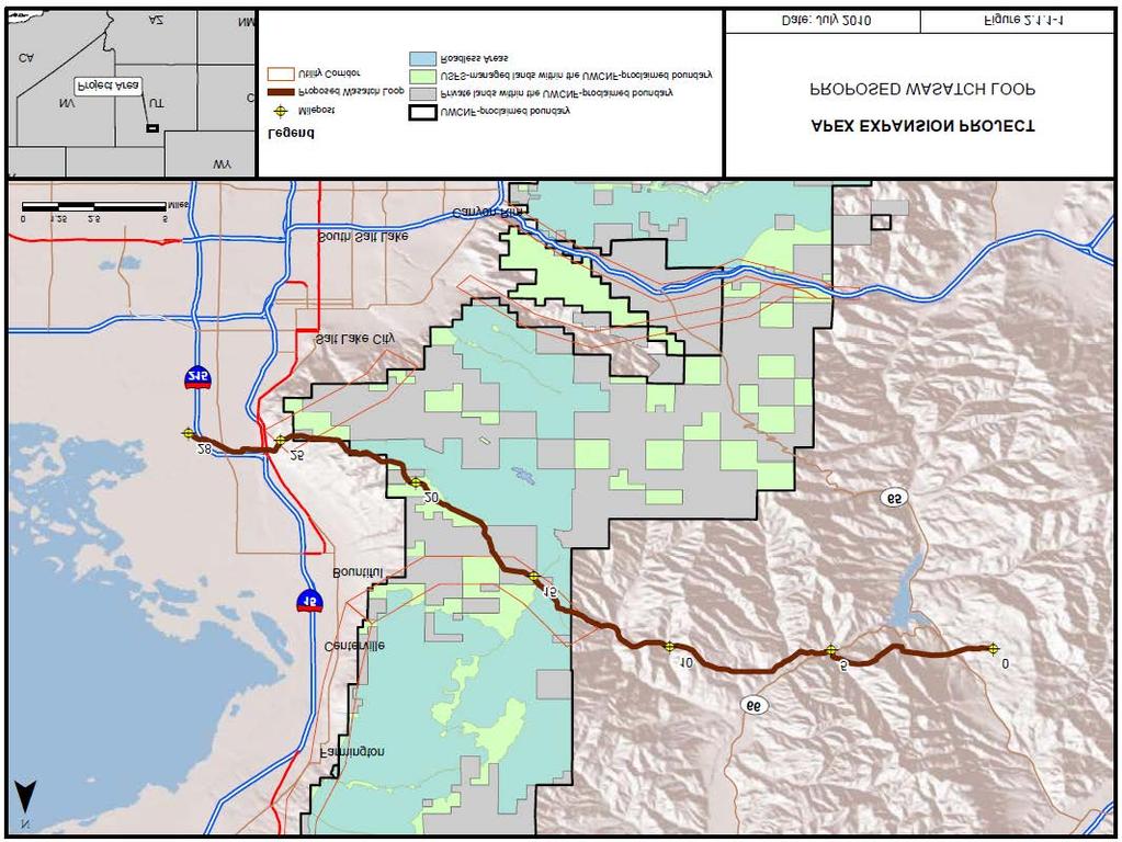
1 FIELD INSPECTION REPORT Date September 25 and 26, 2016 Project Kern River Gas Transmission Company (Kern River) Apex Expansion Project Utah, Millard, Beaver, Morgan, Davis, and Salt Lake Counties, Utah; Uinta County, Wyoming; Clark County, Nevada Authority: Section 7(c) Personnel FERC Project Manager: Company Staff: David Hanobic Callee Butcher, Kern River Heather Evans, Kern River Inspection Summary 0 Problem Area(s) 0 Noncompliance(s) No No Follow-Up Letter Required Refer to Enforcement Introduction On September 25 and 26, 2016, David Hanobic, of the Commission staff, performed a restoration inspection of the Apex Expansion Project. The project consists of approximately 28 miles of 36-inch-diameter pipeline loop in Morgan, Davis, and Salt Lake Counties, Utah; modification to four existing compressor stations (Coyote Creek Compressor Station in Uinta County, Wyoming; Elberta Compressor Station in Utah County, Utah; Dry Lake Compressor Station in Clark County, Nevada; and Fillmore Compressor Station in Millard County, Utah); and construction of the new Milford Compressor Station in Beaver County, Utah. The project construction period was September 2010 to October The in-service date was October 1, The inspection consisted of a helicopter overflight of the pipeline right-of-way and on-the-ground inspections. The purpose of the inspection was to determine Kern River s compliance with the environmental conditions of the Commission s Order for the subject project and to inspect the restoration conditions of the pipeline right-of-way. The findings of the inspection were that no instances of problem areas or noncompliance were observed. The photographic record shows various photos taken during the inspection with a brief description of what was observed. A site map is also attached.
2 Inspection The weather conditions were sunny with temperatures in the mid 50s o F on September 25, but varied greatly on September 26 when the inspection covered different elevations. According to the month of September rainfall amounted to 0.89 inch in Salt Lake City, Utah. This measurement is likely not accurate over most of the project, as more rain tends to fall within the mountainous areas east of Salt Lake City. There was fresh snowpack in the higher elevations from a storm the weekend before the inspection. The inspection occurred on foot on September 25 and consisted of the area near Sessions Road. On September 26, the inspection occurred by helicopter and started at milepost 0.0 and followed the rightof-way back to Bountiful, Utah to the residential areas at the base of the Wasatch Range (approximately milepost 25). The right-of-way appears stable and the majority of the right-of-way was revegetated. All slope breakers appear fully functional and no major areas of erosion were noted. Grazing by livestock continues to be a factor that makes restoration much more difficult in some areas, although it appears to be less of an issue compared to the inspections in 2013 and Kern River has continued to work with landowners, although most are not agreeable to fencing off the right-ofway to reduce grazing pressure while vegetation is established. Photo 1 shows an area west of Sessions Road. The right-of-way here is stable and restored. Photo 2 shows a slope breaker near Sessions Road functioning by diverting snowmelt off of the right-of-way. No erosion was noted. Photo 3 shows the areas of concern that were noted in 2013 and 2014 because of heavy sheep grazing. Although some areas still lack vegetation due to the severe compaction caused by extremely heavy grazing, the right-of-way was stable. When up close in the areas that appear bare, small vegetation can be seen in the compacted areas. Kern River has seeded this area and revegetation is proceeding satisfactorily. Kern River is also working with and the U.S. Forest Service (USFS) to replace fences as needed. Photo 9 shows the previously identified problem area near Woods Creek, which was also caused by grazing. The areas still show pressure from grazing, but vegetation has increased and the right-of-way was stable with no erosion noted. Photos 6-8 and show the right-of-way condition over various portions of the right-of-way from the helicopter overflight. As mentioned above, revegetation is considered to be successful for the majority of the right-of-way. Only a few areas of minimal vegetation were noted. Natural recruitment of species that are adjacent to the right-of-way was also noted. Numerous large cracks in the soil associated with sidehill construction noted in the September 2013 inspection have been addressed by Kern River and were restored. None remained visible during the 2016 overflight. Conclusions and Recommendations A follow-up letter is not required at this time because no instances of problem areas or noncompliance were observed. Kern River was asked to provide photos after the next growing season of the area near Sessions Road, to show if vegetation continues to increase in these areas. No additional restoration inspections are recommended. With the exception of the small area near Sessions Road, we consider restoration to be complete. 2
3 SITE MAP
4


5 Photo No.: 1 Date: September 25, 2016 Approx. MP: 14.5 Direction: West Comments: Right-of-way is stable and revegetation is considered successful in this area. The white patches through this area are mostly from recent snowfall. Photo No.: 2 Date: September 25, 2016 Approx. MP: 14.5 Direction: East Comments: The waterbar can be seen functioning by diverting snowmelt off of the right-of-way. No erosion behind the waterbar was noted and revegetation is considered successful in this area.
 where the right-ofway was grazed heavily which resulted in heavy compaction in 2013. This area was reseeded in 2015.")
 highlights the progress (red arrows show location of the same trees for reference).")
6 Photo No.: 3 Date: September 25, 2016 Approx. MP: 14.5 Direction: Northeast Comments: Area near Sessions road (USFS owned) where the right-ofway was grazed heavily which resulted in heavy compaction in This area was reseeded in Although some bare areas were noted in this inspection, the vegetation has progressed substantially since September The photo from September 2014 (below) highlights the progress (red arrows show location of the same trees for reference). It does appear that some areas are still struggling to reestablish vegetation. These areas are not eroding or resulting in an unstable right-of-way. As long as grazing continues to avoid this area, revegetation should continue. Revegetation is proceeding satisfactorily in this location.

7 Photo No.: 4 Approx. MP: 0.5 Direction: West Comments: Right-of-way stable. Vegetation is consistent with off right-of-way vegetation. Restoration is successful.

8 Photo No.: 5 Approx. MP: 3.0 Direction: Northwest Comments: Right-of-way stable. Vegetation is consistent with off right-of-way vegetation. Restoration is successful.

9 Photo No.: 6 Approx. MP: 3.75 Direction: NA Comments: Right-of-way is stable. Vegetation is consistent with off right-of-way vegetation. Wildlife and grazing trails are visible on and off of the right-of-way. Restoration is successful.
 vegetation.")
10 Photo No.: 7 Approx. MP: 4.0 Direction: Northwest Comments: Right-of-way is stable. Vegetation is consistent with off right-of-way (non-forested) vegetation. Restoration is successful.

11 Photo No.: 8 Approx. MP: 7.5 Direction: West Comments: Right-of-way is stable. Vegetation is consistent with off right-of-way vegetation. Restoration is successful.


12 Photo No.: 9 Approx. MP: 7.8 Direction: NA Comments: Woods Creek. In our 2013 and 2014 inspections, vegetation was sparse and cattle grazing the area caused revegetation efforts to be unsuccessful. Soils were very powdery and loose. The landowner would not allow exclusion of cattle. In 2016, the right-of-way was vegetated, although sparse in a few areas and still under grazing pressure. The stream at the valley bottom draws livestock to the area. Vegetation density is increasing from 2014, and no erosion was noted. Restoration is proceeding satisfactorily in this area. Red arrows show the same shrubs from 2014 to 2016 for reference.
 vegetation.")
13 Photo No.: 10 Approx. MP: 12.5 Direction: NA Comments: Right-of-way is stable. Vegetation is consistent with off right-of-way (non-forested) vegetation. Restoration is successful.

14 Photo No.: 11 Approx. MP: 15.5 Direction: NA Comments: Right-of-way is stable. Slope breakers were functioning with no erosion noted. Vegetation is consistent with off right-of-way (non-forested) vegetation. Restoration is successful.
 vegetation.")
15 Photo No.: 12 Approx. MP: 20 Direction: Southewest Comments: Right-of-way is stable. Vegetation is consistent with off right-of-way (non-forested) vegetation. Restoration is successful.
 vegetation.")
16 Photo No.: 13 Approx. MP: 23 Direction: Southwest Comments: Right-of-way is stable. Vegetation is consistent with off right-of-way (non-forested) vegetation. Good growth of shrubbery was noted on right-of-way. Restoration is successful.
CT EXPANSION PROJECT SILT FENCE DESIGN CRITERIA AND METHODOLOGY CONNECTICUT LOOP. Submitted by:..
 CT EXPANSION PROJECT SILT FENCE DESIGN CRITERIA AND METHODOLOGY CONNECTICUT LOOP Submitted by:.. Tennessee Gas Company L.L.C. 1001 Louisiana St, Suite 1000 Houston, TX 77002 July 2014 Revised March 2015
The Lake Creek Ranch. Located in the foothills of the Owl Creek Mountains in western Hot Springs County, Wyoming
 The Lake Creek Ranch Located in the foothills of the Owl Creek Mountains in western Hot Springs County, Wyoming Experienced Professional Ranch Brokers Specializing in the sale of ranches, farms, & recreational
Pre-Application Document Kaweah Project (FERC Project No. 298)
") TABLE OF CONTENTS Page 3.12 Aesthetic Resources... 3.12-1 3.12.1 Information Sources... 3.12-1 3.12.2 Setting... 3.12-1 3.12.3 Project Facilities... 3.12-2 3.12.4 Previous Visual Resources Assessment...
TABLE OF CONTENTS Page 3.12 Aesthetic Resources... 3.12-1 3.12.1 Information Sources... 3.12-1 3.12.2 Setting... 3.12-1 3.12.3 Project Facilities... 3.12-2 3.12.4 Previous Visual Resources Assessment...
CLYDE RIVER FISH KILL 2016 PRELIMINARY REPORT
 CLYDE RIVER FISH KILL 2016 PRELIMINARY REPORT November 2016 CLYDE RIVER FISH KILL PRELIMINARY REPORT, NOVEMBER 2016 SUMMARY A fish kill on Clyde River was reported to e Prince Edward Island Department
PARADISE CANYON RANCH
 PARADISE CANYON RANCH 4,413 Acres Lost Creek - Morgan County - Utah A5 REAL ESTATE WWW.A5REALESTATE.COM A5 REAL ESTATE 2 Paradise Canyon Ranch QUICK FACTS Located in upper Lost Creek, Morgan County, Utah
La Crescent Township Zoning Ordinance
 La Crescent Township Zoning Ordinance Table of Contents SECTION 1 ~ PREAMBLE, TITLE, SHORT TITLE AND PURPOSE... 1 0101 Preamble... 1 0102 Title... 1 0103 Short Title... 1 0104 Purpose... 1 SECTION 2 ~
California golden trout: can their warming streams handle cattle grazing and climate change?
 California golden trout: can their warming streams handle cattle grazing and climate change? Kathleen R. Matthews USDA Forest Service Research Conservation of Biodiversity Program Pacific Southwest Research
Starlite Ranch INTERMOUNTAIN REALTY GROUP S Holladay Blvd., Salt Lake City, Utah,
 Starlite Ranch Millard County, Utah 960 Acres $795,000 INTERMOUNTAIN REALTY GROUP 4571 S Holladay Blvd., Salt Lake City, Utah, 84117 801-277-0800 www.intermountainrealtygroup.com Welcome to Starlite Ranch
TWO FORKS RANCH A5 REAL ESTATE. 790 Acres. Smiths Fork - Lincoln County - Wyoming
 TWO FORKS RANCH 790 Acres Smiths Fork - Lincoln County - Wyoming A5 REAL ESTATE WWW.A5REALESTATE.COM QUICK FACTS Located in the upper Smiths Fork drainage of Lincoln County, Wyoming, the Two Forks Ranch
FINAL REPORT. Yonkers Creek Migration Barrier Removal Project Wonderstump Road Del Norte County. Submitted By:
 FINAL REPORT Yonkers Creek Migration Barrier Removal Project Wonderstump Road Del Norte County Submitted By: Del Norte County Community Development Department Yonkers Creek Migration Barrier Removal Project
UNDERWATER BRIDGE INSPECTION REPORT STRUCTURE NO CSAH NO. 9 OVER THE BLUE EARTH RIVER DISTRICT 7 - BLUE EARTH COUNTY
 UNDERWATER BRIDGE INSPECTION REPORT STRUCTURE NO. 07542 CSAH NO. 9 OVER THE BLUE EARTH RIVER DISTRICT 7 - BLUE EARTH COUNTY PREPARED FOR THE MINNESOTA DEPARTMENT OF TRANSPORTATION BY COLLINS ENGINEERS,
SOLITUDE MOUNTAIN RESORT MASTER DEVELOPMENT PLAN AMENDMENT PROPOSAL
 SOLITUDE MOUNTAIN RESORT MASTER DEVELOPMENT PLAN AMENDMENT PROPOSAL 6/02/14 INTRODUCTION Solitude Mountain Resort s (Solitude) current Master Development Plan (MDP) was accepted by the Wasatch-Cache National
VWP CONSTRUCTION INSPECTION REPORT. Project Name: Berkmar Drive Extension Locality: Albemarle County Inspector: ERM
 VWP CONSTRUCTION INSPECTION REPORT Inspection Date: August 22, 2016 VWP Permit No. 15-1268 SPGP RO Project Name: Berkmar Drive Extension Locality: Albemarle County Inspector: ERM Impacts: PFO PEM PSS POW
This is a digital document from the collections of the Wyoming Water Resources Data System (WRDS) Library.
 Library.") This is a digital document from the collections of the Wyoming Water Resources Data System (WRDS) Library. For additional information about this document and the document conversion process, please contact
This is a digital document from the collections of the Wyoming Water Resources Data System (WRDS) Library. For additional information about this document and the document conversion process, please contact
Utah. North Stansbury Mountains Wilderness Study Area Site-Specific Monitoring Guide
 Utah North Stansbury Mountains Wilderness Study Area Site-Specific Monitoring Guide 1 General Information WildSNAP Monitoring Peter Woodruff, American Conservation Experience Coordinator Phone (801) 989-7069
Florida Seagrass Integrated Mapping and Monitoring Program
 Florida Seagrass Integrated Mapping and Monitoring Program - 2004 The following document is composed of excerpts taken from the 2011 publication, Seagrass Integrated Mapping and Monitoring for the State
STEELHEAD SURVEYS IN OMAK CREEK
 STEELHEAD SURVEYS IN OMAK CREEK 2002 Annual Report Prepared by Chris Fisher John Arterburn Colville Confederated Tribes Fish and Wildlife Department P.O. Box 150 Nespelem, WA 99155 Prepared for Project
WILDLIFE HERITAGE TRUST ACCOUNT PROJECT PROPOSAL FORM
 APPLICANT INFORMATION WILDLIFE HERITAGE TRUST ACCOUNT PROJECT PROPOSAL FORM Person/Organization/Agency Nevada Department Of Wildlife (NDOW) Name Mike Cox Title Big Game Staff Biologist Address 1 4600 Kietzke
Rehabilitation of Grimes Creek, a Stream Impacted in the Past by Bucket-lined Dredge Gold Mining, Boise River Drainage, July 2008 to August 2011.
 Rehabilitation of Grimes Creek, a Stream Impacted in the Past by Bucket-lined Dredge Gold Mining, Boise River Drainage, July 2008 to August 2011. Pam Harrington TU,1020 W. Main Street Suite 440, Boise,
Searle Ranch. Fillmore, Utah 240 Acres $848, Elmwood Street, Salt Lake City, UT
 Searle Ranch Fillmore, Utah 240 Acres $848,000 3616 Elmwood Street, Salt Lake City, UT 84106 801-870-1801 info@landrancher.com Welcome to Searle Ranch Featuring: 240 acres completely surrounded by BLM
NEVADA DEPARTMENT OF WILDLIFE STATEWIDE FISHERIES MANAGEMENT
 NEVADA DEPARTMENT OF WILDLIFE STATEWIDE FISHERIES MANAGEMENT FEDERAL AID JOB PROGRESS REPORTS F-20-52 2016 REDBAND TROUT EASTERN REGION NEVADA DEPARTMENT OF WILDLIFE, FISHERIES DIVISION ANNUAL JOB PROGRESS
2017 LATE WINTER CLASSIFICATION OF NORTHERN YELLOWSTONE ELK
 2017 LATE WINTER CLASSIFICATION OF NORTHERN YELLOWSTONE ELK A collaborative survey by the Northern Yellowstone Cooperative Wildlife Working Group Report Prepared by: Karen Loveless, Montana Fish Wildlife
D.B. Wilson Station CCR Landfill
 D.B. Wilson Station CCR Landfill Disposal of Coal Combustion Residuals (CCR) from Electric Utilities Final Rule Closure and Post-closure Care Plan October 11, 2016 Prepared By: Project ID: 160030A Big
UNDERWATER BRIDGE INSPECTION REPORT STRUCTURE NO CSAH NO. 7 OVER THE SNAKE RIVER DISTRICT 1 - PINE COUNTY
 UNDERWATER BRIDGE INSPECTION REPORT STRUCTURE NO. 58506 CSAH NO. 7 OVER THE SNAKE RIVER DISTRICT 1 - PINE COUNTY PREPARED FOR THE MINNESOTA DEPARTMENT OF TRANSPORTATION BY COLLINS ENGINEERS, INC. JOB NO.
2012 Diamond Complex Assessment BLM administered: Battle Mountain, Ely, Elko districts
 2012 Diamond Complex Assessment BLM administered: Battle Mountain, Ely, Elko districts wild horse removal scheduled January 2013 Horse Canyon, Diamond HMA July 2012 Preliminary Report (Final Version) of
(Revised February,2005) CULVERTS, BRIDGES, AND FORDS
 CULVERTS, BRIDGES, AND FORDS") GUIDE TO STREAM CROSSINGS (Revised February,2005) CULVERTS, BRIDGES, AND FORDS Culverts, bridges, and fords are all methods used to cross-streams. Culverts are the most common stream crossing structure.
GUIDE TO STREAM CROSSINGS (Revised February,2005) CULVERTS, BRIDGES, AND FORDS Culverts, bridges, and fords are all methods used to cross-streams. Culverts are the most common stream crossing structure.
NEVADA DEPARTMENT OF WILDLIFE STATEWIDE FISHERIES MANAGEMENT
 NEVADA DEPARTMENT OF WILDLIFE STATEWIDE FISHERIES MANAGEMENT FEDERAL AID JOB PROGRESS REPORT F-20-50 2014 LAHONTAN CUTTHROAT TROUT STUDY WESTERN REGION NEVADA DEPARTMENT OF WILDLIFE, FISHERIES DIVISION
placed on the market.
 With Mimbres River frontage and tremendous grass forage, this jewel in New Mexico s Southern Gila Region is a must have for the discriminating buyer looking to have it all in one easily operated grazing
WHITEFISH & ROCK CREEK RANCH
 WHITEFISH & ROCK CREEK RANCH DONLEY COUNTY, TEXAS 3,553.59 ± ACRES Texas Panhandle Live-Water Cattle & Recreational Ranch WHITEFISH & ROCK CREEK RANCH DONLEY COUNTY, TEXAS 3,553.59 ± ACRES We are pleased
ACTION PLAN FOR AER DECISION PEMBINA PIPELINE CORPORATION APPLICATIONS FOR TWO PIPELINES - PIPELINE EXPANSION PROJECT, FOX CREEK TO NAMAO
 ACTION PLAN FOR AER DECISION PEMBINA PIPELINE CORPORATION APPLICATIONS FOR TWO PIPELINES - PIPELINE EXPANSION PROJECT, FOX CREEK TO NAMAO ACTION ITEM 1 Mr. Nielsen s Property Pembina must reduce the permanent
4.7 Landscape Provisions.
 4.7. A. Intent. Landscaping of required Yards and required Bufferyards is an essential element of the design of a site with respect to promoting the public health, safety, comfort, convenience and general
Graphing population size daily Review Deer: Predation or Starvation
 : Predation or Starvation Introduction: In 1970 the deer population of an island forest reserve about 518 square kilometers in size was about 2000 animals. Although the island had excellent vegetation
Twin Canyons Ranch 3,019+/- Acres Throckmorton County, Texas $4,211,505 ($1,395/acre)
") Office: (214) 361-9191 Twin Canyons Ranch 3,019+/- Acres Throckmorton County, Texas $4,211,505 ($1,395/acre) GENERAL DESCRIPTION: The 3019+/- acre Twin Canyons Ranch is one of the most scenic and majestic
Office: (214) 361-9191 Twin Canyons Ranch 3,019+/- Acres Throckmorton County, Texas $4,211,505 ($1,395/acre) GENERAL DESCRIPTION: The 3019+/- acre Twin Canyons Ranch is one of the most scenic and majestic
Moser Dome Ranch. Silesia, Montana $895,000.
 MOSER DOME RANCH Moser Dome Ranch Silesia, Montana $895,000. Offered Exclusively By: Sonny Todd Real Estate 301 W First, PO Box 788 Big Timber, MT 59011 Office: (406) 932-6668 (406) 932-LAND Toll Free:
City of Burnaby Environmental Review Committee (ERC) Guide for Applicants
 Guide for Applicants") City of Burnaby Environmental Review Committee (ERC) Guide for Applicants 2017-2018 This Guide summarizes the ERC process for project review including applications for a relaxation (variance) to the development
City of Burnaby Environmental Review Committee (ERC) Guide for Applicants 2017-2018 This Guide summarizes the ERC process for project review including applications for a relaxation (variance) to the development
Climate change and the California golden trout
 Climate change and the California golden trout Kathleen R. Matthews US Forest Service Research Sierra Nevada Research Center Outline Golden trout background How climate change may impact CGT and their
Initial Annual CCR Landfill Inspection OML Existing Landfill OML Expansion Phase 1
 Initial Annual CCR Landfill Inspection OML Existing Landfill OML Expansion Phase 1 Ottumwa-Midland Landfill Prepared for: Ottumwa-Midland Landfill 15300 130 th Street Ottumwa, Iowa 52501 Prepared by: SCS
Interagency Special Status/Sensitive Species Program FY2005 Inventory & Conservation Planning Status Report
 Interagency Special Status/Sensitive Species Program FY2005 Inventory & Conservation Planning Status Report PROJECT TITLE: Crooked River National Grassland Pygmy Rabbit Habitat Assessment and Survey PROJECT
UNDERWATER BRIDGE INSPECTION REPORT DISTRICT 8 - LAC QUI PARLE COUNTY
 UNDERWATER BRIDGE INSPECTION REPORT STRUCTURE NO. 6391 CSAH NO. 33 OVER THE MINNESOTA RIVER DISTRICT 8 - LAC QUI PARLE COUNTY PREPARED FOR THE MINNESOTA DEPARTMENT OF TRANSPORTATION BY COLLINS ENGINEERS,
UNDERWATER BRIDGE INSPECTION REPORT METRO DISTRICT - ANOKA COUNTY
 UNDERWATER BRIDGE INSPECTION REPORT STRUCTURE NO. 02545 CR NO. 116 OVER THE RUM RIVER METRO DISTRICT - ANOKA COUNTY SEPTEMBER 9, 2012 PREPARED FOR THE MINNESOTA DEPARTMENT OF TRANSPORTATION BY COLLINS
OVERVIEW OF MID-COLUMBIA FISHERIES ENHANCEMENT GROUP
 Mid-Columbia Fisheries Enhancement Group MISSION STATEMENT The Mid-Columbia Fisheries Enhancement Group is a non-profit organization dedicated to restoring selfsustaining salmon and steelhead populations
UNDERWATER BRIDGE INSPECTION REPORT STRUCTURE NO CSAH 133 OVER A DITCH ST. LOUIS COUNTY
 UNDERWATER BRIDGE INSPECTION REPORT STRUCTURE NO. 7780 CSAH 133 OVER A DITCH ST. LOUIS COUNTY SEPTEMBER 27, 2012 PREPARED FOR THE MINNESOTA DEPARTMENT OF TRANSPORTATION BY COLLINS ENGINEERS, INC. JOB NO.
2016 Annual Inspection Report
 2016 Annual Inspection Report for Compliance with the Coal Combustion Residuals Rule (40 CFR Part 257) Pawnee Station 14940 Morgan County Road 24 Brush, Colorado 80723 January 18, 2017 Table of Contents
MOOSE SURVEY RACKLA AREA LATE-WINTER Prepared by: Mark O'Donoghue, Joe Bellmore, Sophie Czetwertynski and Susan Westover
 MOOSE SURVEY RACKLA AREA LATE-WINTER 2013 Prepared by: Mark O'Donoghue, Joe Bellmore, Sophie Czetwertynski and Susan Westover October 2013 MOOSE SURVEY RACKLA AREA LATE-WINTER 2013 Yukon Department of
3/8/2016 Oregon Wallowa Mountains Published by Michael Hatch (Wallowa Avalanche Center) and Scott Savage (on behalf of USFS National Avalanche Center)
 and Scott Savage (on behalf of USFS National Avalanche Center)") Location: Place Chief Joseph Peak, Wallowa Mountains State Oregon Date 3/8/2016 Time 1630 hrs Summary 1 skier partially buried and killed Number: Caught 1 Fully Buried 0 Injured 0 Killed 1 Avalanche Details:
Location: Place Chief Joseph Peak, Wallowa Mountains State Oregon Date 3/8/2016 Time 1630 hrs Summary 1 skier partially buried and killed Number: Caught 1 Fully Buried 0 Injured 0 Killed 1 Avalanche Details:
SKINNER MEADOWS RANCH
 SKINNER MEADOWS RANCH JACKSON, MONTANA $3,999,000 I 885+/- ACRES LISTING AGENT: KEITH HANDLOS 10 WEST REEDER STREET DILLON, MT 59725 P: 406.683.2234 M:406.925.1814 KHANDLOS@BEAVERHEADHOMEANDRANCH.COM EXECUTIVE
Mid-Columbia Fisheries Enhancement Group Annual Report Fiscal Year 06: July 1, 2005 June 30, 2006
 Mid-Columbia Fisheries Enhancement Group Annual Report Fiscal Year 06: July 1, 2005 June 30, 2006 Mission Statement The mission of the Mid-Columbia Fisheries Enhancement Group is to restore self-sustaining
Stevens Creek Corridor
 O F F I C E O F T H E D I R E C T O R O F P U B L I C W O R K S Stevens Creek Corridor Creek Restoration Project Volume Three Project Update: Creek Photos, Before & After BY GAIL SEEDS - PROJECT MANAGER,
Non-Lethal Deterrents Grant Application Additional Site Form
 BENTON COUNTY NATURAL AREAS & PARKS LAURIE STARHA DIRECTOR HTTP://CO.BENTON.OR.US/AWPP Non-Lethal Deterrents Grant Application Additional Site Form Benton County Agriculture and Wildlife Protection Program
Annual CCR Landfill Inspection OML Existing Landfill OML Expansion Phase 1
 Annual CCR Landfill Inspection OML Existing Landfill OML Expansion Phase 1 Ottumwa-Midland Landfill Prepared for: Ottumwa-Midland Landfill 15300 130 th Street Ottumwa, Iowa 52501 Prepared by: SCS ENGINEERS
TROUT CREEK WATERSHED (Second Year of Snowline Data)
") Extent of Snow Cover During the 2002 Spring Freshet For the TROUT CREEK WATERSHED (Second Year of Snowline Data) (Penticton Forest District) 1.0 INTRODUCTION The extent of snow cover over a watershed basin
Extent of Snow Cover During the 2002 Spring Freshet For the TROUT CREEK WATERSHED (Second Year of Snowline Data) (Penticton Forest District) 1.0 INTRODUCTION The extent of snow cover over a watershed basin
UNDERWATER BRIDGE INSPECTION REPORT DISTRICT 1 PINE COUNTY
 UNDERWATER BRIDGE INSPECTION REPORT STRUCTURE NO. 58551 CSAH NO. 41 OVER THE KETTLE RIVER DISTRICT 1 PINE COUNTY JULY 28, 2012 PREPARED FOR THE MINNESOTA DEPARTMENT OF TRANSPORTATION BY COLLINS ENGINEERS,
EXECUTIVE SUMMARY Feasibility Study on the Reintroduction of Gray Wolves to the Olympic Peninsula
 EXECUTIVE SUMMARY Feasibility Study on the Reintroduction of Gray Wolves to the Olympic Peninsula Prepared by U.S. Fish and Wildlife Service Western Washington Office Introduction Historical records indicate
Cross F & Diamond Ranches Sunflower, Maricopa County, AZ
 Sunflower, Maricopa County, AZ Offered for sale exclusively by: Paul Groseta Headquarters West Ltd. 51 Verde Heights Drive, Suite A P.O. Box 1840 Cottonwood, AZ 96326 Phone: (928) 634-8110; Fax (928) 634-2113;
Subject to sale, withdrawal, or error.
 We are privileged to have the exclusive listing on a very scenic ranch in the beautiful western foothills of the Jemez Mountains in the northwest central area of New Mexico. This outstanding offering is
UNDERWATER BRIDGE INSPECTION REPORT STRUCTURE NO MSAS 123 (2 ND AVE. SW) OVER THE CANNON RIVER CITY OF FARIBAULT, RICE COUNTY
 OVER THE CANNON RIVER CITY OF FARIBAULT, RICE COUNTY") UNDERWATER BRIDGE INSPECTION REPORT STRUCTURE NO. 66546 MSAS 123 (2 ND AVE. SW) OVER THE CANNON RIVER CITY OF FARIBAULT, RICE COUNTY SEPTEMBER 13, 2012 PREPARED FOR THE MINNESOTA DEPARTMENT OF TRANSPORTATION
UNDERWATER BRIDGE INSPECTION REPORT STRUCTURE NO. 66546 MSAS 123 (2 ND AVE. SW) OVER THE CANNON RIVER CITY OF FARIBAULT, RICE COUNTY SEPTEMBER 13, 2012 PREPARED FOR THE MINNESOTA DEPARTMENT OF TRANSPORTATION
Video zone How wolves change rivers
 Video zone How wolves change rivers Tasks Instructions Do the preparation task first. Then watch the video and do the exercise. You can also read the transcript. Preparation task Match the definitions
UNDERWATER BRIDGE INSPECTION REPORT STRUCTURE NO OVER THE STRAIGHT RIVER DISTRICT 6 - RICE COUNTY
 UNDERWATER BRIDGE INSPECTION REPORT STRUCTURE NO. 66513 14 th STREET (MSAS NO. 103) OVER THE STRAIGHT RIVER DISTRICT 6 - RICE COUNTY PREPARED FOR THE MINNESOTA DEPARTMENT OF TRANSPORTATION BY COLLINS ENGINEERS,
Lookout Mountain Ranch
 Lookout Mountain Ranch Daniel, Wyoming John Turner, Broker/Partner LiveWaterProperties.com Toll Free 866.734.6100 LOCATION: The Lookout Mountain Ranch is located 15 miles northwest of Daniel Junction in
Encampment River-Elk River drainage divide area landform origins along USA Missouri River drainage basin landform origins research project
 10/5/12 7:30 PM Encampment River-Elk River drainage divide area landform origins along the continental divide in the Wyoming and Colorado Sierra Madre Mountains and Park Range, USA October 5, 2012! Colorado,
City of Santa Cruz Interim Tarplant Management
 City of Santa Cruz Interim Tarplant Management 1995-2011 In 2002 65 acres of Arana Gulch was designated as critical habitat for the Santa Cruz tarplant by the U.S. Fish and Wildlife Service (USFWS). The
UNDERWATER BRIDGE INSPECTION REPORT STRUCTURE NO B WABASHA STREET SOUTH BOUND (MASA 235 SB)
") UNDERWATER BRIDGE INSPECTION REPORT STRUCTURE NO. 62555B WABASHA STREET SOUTH BOUND (MASA 235 SB) OVER THE MISSISSIPPI RIVER CITY OF ST. PAUL OCTOBER 31, 2012 PREPARED FOR THE MINNESOTA DEPARTMENT OF TRANSPORTATION
UNDERWATER BRIDGE INSPECTION REPORT STRUCTURE NO. 62555B WABASHA STREET SOUTH BOUND (MASA 235 SB) OVER THE MISSISSIPPI RIVER CITY OF ST. PAUL OCTOBER 31, 2012 PREPARED FOR THE MINNESOTA DEPARTMENT OF TRANSPORTATION
North Platte River-Little Snake River drainage divide area landform origi s, USA Missouri River drainage basin landform origins research project
 North Platte River-Little Snake River drainage divide area landform origins along the continental divide in the Wyoming and Colorado Sierra Madre Mountains, USA October 3, 2012! Colorado, east-west continental
Results of Argali Survey in Big Pamir and the Wakhjir Valley by the Marco Polo Sheep Survey Team 2008
 Results of Argali Survey in Big Pamir and the Wakhjir Valley by the Marco Polo Sheep Survey Team 2008 Dr. John Winnie Jr. 1) A comparison of the habitat data points revealed that grassy habitats in the
FINAL HARRIS CHAIN OF LAKES RESTORATION COUNCIL SITE VISIT SUMMARY. of the. Projects Tour March 3, 2006
 FINAL HARRIS CHAIN OF LAKES RESTORATION COUNCIL SITE VISIT SUMMARY of the Projects Tour March 3, 2006 The regular meeting of the Harris Chain of Lakes Restoration Council (Council) was cancelled to facilitate
John Fletcher Vann was born in Madison County in East Texas in His parents died at a young age and he was
 Subject Sb tt to os sale,,w withdrawal, wal,o or re error. ro r. The Vann Ranch is located on the Colorado River at the head waters of Lake Buchanan, just south of the Colorado Bend State Park. This scenic
Raleigh Park Open House #2 Summary (5/23/17)
") Raleigh Park Open House #2 Summary (5/23/17) Nearly 50 community members participated in an open house meeting about Raleigh Park on 5/23/17. During the meeting, staff presented concepts for changes to
Raleigh Park Open House #2 Summary (5/23/17) Nearly 50 community members participated in an open house meeting about Raleigh Park on 5/23/17. During the meeting, staff presented concepts for changes to
LONG CREEK, OREGON APPROXIMATELY 1,313 TOTAL DEEDED ACRES
 LONG CREEK, OREGON APPROXIMATELY 1,313 TOTAL DEEDED ACRES OVER 1 MILE LONG CREEK THRU PROPERTY OVER 4/5 MILE MALHEUR NATIONAL FOREST FRONTAGE 3 ea. LANDOWNER HUNTING TAGS DEER & ELK SEASONAL SUMMER GRAZING
The Lesson of the Kaibab
 Morales Biology Name Date Period The Lesson of the Kaibab Introduction: The environment may be altered by forces within the biotic community, as well as by relationships between organisms and the physical
Mule Deer. Dennis D. Austin. Published by Utah State University Press. For additional information about this book
 Mule Deer Dennis D. Austin Published by Utah State University Press Austin, D.. Mule Deer: A Handbook for Utah Hunters and Landowners. Logan: Utah State University Press, 2010. Project MUSE., https://muse.jhu.edu/.
*** FULL REPORT FROM THE WCMAC *** View report and photos online at:
 Date: 2014-05-03 Submitted By: Steve Karkanen, West Central Montana Avalanche Center (WCMAC) Place: Olson Gulch, Flint Creek Range, 10 miles NW of Anaconda, MT State: MT Country: USA Fatalities: 1 Summary:
DEVIL S GARDEN PLATEAU WILD HORSE TERRITORY
 DEVIL S GARDEN PLATEAU WILD HORSE TERRITORY EVALUATION OF MONITORING DATA FOR THE PURPOSE OF DETERMINING AN APPROPRIATE MANAGEMENT LEVEL Pacific Southwest Region Devil s Garden and Doublehead Ranger Districts
Final Review of New Information Appendix E AMPs-Sheep Allotments in Gravelly Mountains. c,llorttarta 'Fisft, MADISON RANGER DISTRICT.
 RECEIVED + MAR 2 2 2017 c,llorttarta 'Fisft, MADISON RANGER DISTRICT J'Wi e 1400 South 19 th Avenue Bozeman MT 59718-5495 March 20, 2017 Dale Olsen Madison Ranger District 5 Forest Service Road Ennis,
Gas Gathering System Modeling The Pipeline Pressure Loss Match
 PETROLEUM SOCIETY CANADIAN INSTITUTE OF MINING, METALLURGY & PETROLEUM PAPER 2005-230 Gas Gathering System Modeling The Pipeline Pressure Loss Match R.G. MCNEIL, P.ENG. Fekete Associates Inc. D.R. LILLICO,
West District Bison Relocation Summary
 West District 2010 Bison Relocation Summary Overview and Statistics Westside bison operations began on May 4, 2010 and ended on June 21, 2010. Twenty-two separate operations were conducted requiring 993
BRENT N. LONNER, Montana Fish, Wildlife & Parks, Fish & Wildlife Division, PO Box 488, Fairfield, MT 59436, USA
 History of Bighorn Sheep in the Sun River Area, Montana BRENT N. LONNER, Montana Fish, Wildlife & Parks, Fish & Wildlife Division, PO Box 488, Fairfield, MT 59436, USA Abstract: The Sun River bighorn sheep
MAYO MOOSE MANAGEMENT UNIT
 MOOSE SURVEY MAYO MOOSE MANAGEMENT UNIT LATE-WINTER 2014 Prepared by: Mark O'Donoghue, Joe Bellmore, Sophie Czetwertynski and Susan Westover July 2016 MOOSE SURVEY MAYO MOOSE MANAGEMENT UNIT LATE-WINTER
2018 WILDLIFE MANAGEMENT PLAN
 2018 WILDLIFE MANAGEMENT PLAN 1 MEMORANDUM TO: FROM: Captain Daniel Wills Officer Dominic Wareham DATE: July 11, 2018 RE: 2018 Wildlife Management Plan CONTENTS I. 2017 Wildlife Management Report II. 2017
Cloverdale Ranch 1, /- Acres Fannin County, Texas $3,997,116 ($2,695/acre) Office: (214)
 Office: (214)") 1,483.16+/- Acres Fannin County, Texas $3,997,116 ($2,695/acre) Office: (214) 361-9191 Fannin County, Texas 1483.16 +/- Acres LOCATION: Historic Cloverdale Ranch is located in northwest Fannin County with
1,483.16+/- Acres Fannin County, Texas $3,997,116 ($2,695/acre) Office: (214) 361-9191 Fannin County, Texas 1483.16 +/- Acres LOCATION: Historic Cloverdale Ranch is located in northwest Fannin County with
If you have any questions, please do not hesitate to contact me at (412) or Thank you.
 or Thank you.") 625 Liberty Avenue, Suite 1700 Pittsburgh, PA 15222 844-MVP-TALK mail@mountainvalleypipeline.info www.mountainvalleypipeline.info March 26, 2018 Ms. Kimberly D. Bose, Secretary Federal Energy Regulatory
625 Liberty Avenue, Suite 1700 Pittsburgh, PA 15222 844-MVP-TALK mail@mountainvalleypipeline.info www.mountainvalleypipeline.info March 26, 2018 Ms. Kimberly D. Bose, Secretary Federal Energy Regulatory
UNDERWATER BRIDGE INSPECTION REPORT DISTRICT 8 - LAC QUI PARLE COUNTY
 UNDERWATER BRIDGE INSPECTION REPORT STRUCTURE NO. 6391 CSAH NO. 33 OVER THE MINNESOTA RIVER DISTRICT 8 - LAC QUI PARLE COUNTY OCTOBER 22, 2012 PREPARED FOR THE MINNESOTA DEPARTMENT OF TRANSPORTATION BY
2012 Susitna River Water Temperature and Meteorological Field Study
 (FERC No. 14241) 2012 Susitna River Water Temperature and Meteorological Field Study Appendix A Prepared for Prepared by URS Corporation Tetra Tech Inc. February 2013 APPENDIX A: PHOTOGRAPHS AND SITE INFORMATION
NEVADA DEPARTMENT OF WILDLIFE STATEWIDE SPORT FISHERIES MANAGEMENT
 NEVADA DEPARTMENT OF WILDLIFE STATEWIDE SPORT FISHERIES MANAGEMENT FEDERAL AID JOB PROGRESS REPORT F-20-53 2017 RUBY MOUNTAIN & EAST HUMBOLDT HIGH MOUNTAIN LAKES NEVADA DEPARTMENT OF WILDLIFE, FISHERIES
Rainbow Springs Ranch
 Rainbow Springs Ranch Family Fishing Paradise Beaver, Utah 3.5 Acres $315,000 INTERMOUNTAIN REALTY GROUP 4543 S Holladay Blvd., Salt Lake City, Utah, 84117 801-277-0800 www.intermountainrealtygroup.com
Heaphy Track Mountain Bike Trial
 Heaphy Track Mountain Bike Trial 2011-2013 September 2013 Report prepared by Jane Roberts, Eric de Boer, Ian Wightwick photo: Stephen Roberts 1 INTRODUCTION In December 2010 the Department of Conservation
UNDERWATER BRIDGE INSPECTION REPORT STRUCTURE NO CSAH 4 OVER THE BEAVER RIVER ST. LOUIS COUNTY
 UNDERWATER BRIDGE INSPECTION REPORT STRUCTURE NO. 7635 CSAH 4 OVER THE BEAVER RIVER ST. LOUIS COUNTY JUNE 18, 2012 PREPARED FOR THE MINNESOTA DEPARTMENT OF TRANSPORTATION BY COLLINS ENGINEERS, INC. JOB
Calaveras Big Trees State Park--South Grove Loop
 Copyright 1999 by Jeff Robinson. You are free to use and reproduce this description for personal, not-for-profit, and not-forbusiness use. Any reproduction other than for personal use, including businesses,
Colorado West Slope Mule Deer Strategy Public Engagement Report
 Colorado West Slope Mule Deer Strategy Public Engagement Report S U M M A R Y P R E S E N T A T I O N T O C O L O R A D O P A R K S A N D W I L D L I F E C O M M I S S I O N P R E S E N T E D BY T H E
The Cerf Pasture is located about 30 miles southeast of Fort Stockton, Texas on the east side of US Highway 285.
 We are proud to offer for sale the Cerf Pasture, which is the eastern portion of the massive Longfellow Ranch. The Longfellow Ranch is a very well known and widely recognized West Texas Ranch comprising
SAFE WALKS PROGRAM FREQUENTLY ASKED QUESTIONS
 SAFE WALKS PROGRAM FREQUENTLY ASKED QUESTIONS Why does the City have a Safe Walks Program? The Safe Walks program was initiated in 2006 at the request of City Council in order to address the increasing
Widow Valley Ranch. Modoc County, California. Proudly Offered By.
 Widow Valley Ranch Modoc County, California Proudly Offered By www.californiaoutdoorproperties.com 707 Merchant Street, Suite 100, Vacaville, Ca 95688 (707) 455-4444 Office (707) 455-0455 Fax info@caoutdoorproperties.com
STUDENT PACKET # 6 Student Exploration: Rabbit Population by Season
 STUDENT PACKET # 6 Student Exploration: Rabbit Population by Season Name_ Date Big Idea 17: Interdependence Benchmark: SC.7.L.17.2: Compare and contrast the relationships among organisms such as mutualism,
Mt Hood Meadows Avalanche Accident
 Mt Hood Meadows Avalanche Accident February 28, 2011 Date: Noon on Monday, 2/28/2011 Submitted by: Joe Sillman, Mt Hood Meadows Pro Patrol and Mark Moore, NWAC Place: Heather Canyon Drainage, Backyards,
Regents Biology LAB. NATURAL CONTROLS OF POPULATIONS
 Period Date LAB. NATURAL CONTROLS OF POPULATIONS The size of populations in a community are regulated in many ways. Some of the controls acting on populations are: the amount of food and water available
The Value of Springs to The Petersen Ranch
 The Value of Springs to The Petersen Ranch Location 60 miles SW of Austin 50 miles North of San Antonio 12 miles West of Blanco 18 miles SE of Fredericksburg 8 miles SW of Luchenbach Ranch Overview 800
Total Suspended Solids, Stable Flow, and Wet Weather Event Monitoring in the Bass River Watershed. December The Cadmus Group, Inc.
 Total Suspended Solids, Stable Flow, and Wet Weather Event Monitoring in the Bass River Watershed December 2004 The Cadmus Group, Inc. Grand Valley State University Annis Water Resources Institute Submitted
Deer Management Unit 152
 Deer Management Unit 152 Geographic Location: Deer Management Unit (DMU) 152 is 386 miles 2 in size and is primarily in southwestern Marquette County. This DMU falls within the moderate snowfall zone and
Deer Management Unit 252
 Deer Management Unit 252 Geographic Location: Deer Management Unit (DMU) 252 is 297 miles 2 in size and is primarily in southeastern Marquette, southwestern Alger and northwestern Delta County. This DMU
FISHERIES BLUE MOUNTAINS ADAPTATION PARTNERSHIP
 FISHERIES A warming climate, by itself, substantially affects the hydrology of watersheds in the Blue Mountains. Among the key hydrologic changes projected under all scenarios for the 2040s and beyond
2018 Annual Inspection Report
 2018 Annual Inspection Report for Compliance with the Coal Combustion Residuals Rule (40 CFR Part 257) Comanche Station 2005 Lime Road Pueblo, Colorado 81006 January 18, 2019 Table of Contents Certification...