Upstreampaddle 25.South arm of the Brunswick River, Simpson s Creek drains the freshwater swamp lands of Tyagarah Nature Reserve, 750 hectares. Furthe
|
|
|
- Rose Owen
- 5 years ago
- Views:
Transcription


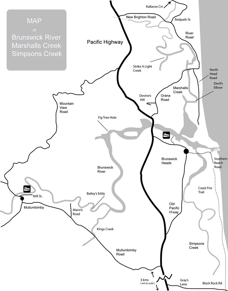
1 Upstreampaddle 24 The Brunswick River is a shorter length river on the coastal plain of Northern New South Wales. The areas of interest to canoeists are: the reach from the town of Mullumbimby down to the river mouth town of Brunswick Heads, 11 kilometres, and the two tidal creeks that flow into the river at the lower town. This area was settled by cedar tree cutters from Marshalls Creek to the north, and Simpsons Creek to the south, run parallel to the coast, behind the coastal dune systems. The area where Marshalls Creek joins the Brunswick is a nature reserve of 84 hectares. A former offshore island, called Harry s Hill has been captured by the process of coastal dune building. The reserve contains an attractive type of vegetation known as Littoral rainforest, or Coastal Vine Scrub. Typical species of the canopy of littoral rainforests include tuckeroo, broad-leaved lilly pilly, Bennets ash, three-veined laurel, brushbox, hard corkwood and emergent hoop pines. The banks of Marshalls Creek are lined with mangroves. In the upper reaches, the trees reach out from the banks, and forms an overhead canopy. Residential housing development lines the last kilometre upstream of Marshalls Creek. above: littoral rainforest, Harry's Hill. above: rainy day photo of the Brunswick River mouth The photograph, above right, was taken from Devines Hill. The visitor, ignoring the pest feral plants of rubber tree and cassia in a garden on the hilltop, can see the Brunswick River below like a map. Note the rock walls at the river mouth, Harry's Hill (the hill left of the river right at the mouth), the start of Simpson's creek, and Cape Byron in the distance. In the photo, below, left, is the panoramic view west, of the river upstream from the Pacific Highway. Further west, not shown, are the distant houses of Mullumbimby. There is vehicle access down a three kilometre long dirt road, North Head road, off Orana Road, to a carpark near Harry's Hill. From there it is 300 metres walk through the littoral rainforest (photo above left) to the northern rock wall at the mouth of the Brunswick River. There are a couple of good places to launch a canoe into Marshalls Creek straight off North Head road. Plan on canoeing in Marshalls Creek two hours before and after the top of the tide, until you get a feel for local conditions.


2 Upstreampaddle 25.South arm of the Brunswick River, Simpson s Creek drains the freshwater swamp lands of Tyagarah Nature Reserve, 750 hectares. Further south is coastal heath on the sand plain between Byron Bay town to the south, and Brunswick Heads to the north. Paperbark trees predominate in the swamp areas; banksias, she-oaks, grass trees and tea tree, in the heathlands. Once a 4wd road ran from Black Rock Road, Tyagarah, seven kilometres north to Brunswick Heads, through the coastal dunes and surrounding banksias and she-oaks. Now it is a walking trail. A partly sealed, part dusty road runs off the Pacific Highway 7.8 kilometres south of the highway bridge over the Brunswick River. The turnoff is signposted Airstrip, and Grays Lane, and turns into Black Rock Road. above: Coast Fire Trail, South Beach road entrance above: paperbark tree swamp, Tyagarah Reserve paper bark swamp sandy beach and surf, at the end of Black Rock road
.")

 and a tree covered hill. The town of Brunswick Heads is along the southern bank of the river.")
3 Upstreampaddle 26 The Pacific Highway crosses the Brunswick River about a kilometre upstream from where the river meets the ocean. You can stand on the rock walls at the mouth and look straight upstream to the road bridge (photo right). It is not far across the channel to the northern rock wall, less than one hundred metres. The water down near the mouth is a pleasant clean sparkling blue. The bar crossing is a dangerous place to be in a powered boat, and unless you have surf skills and enjoy rolling back up and bracing, stay clear. As can be expected there can be a strong ebb tidal flow, and youngsters should not be left unsupervised in a canoe anywhere near the mouth (photo right). On the northern side are pretty little rock coves with yellow sandy beaches, (right) and a tree covered hill. The town of Brunswick Heads is along the southern bank of the river. On the northern bank opposite town, Marshalls Creek runs north behind the coastal dunes up to New Brighton. Simpsons Creek (photo over page) runs south behind the beach on the southern side, for about seven kilometers up to behind the Tyagarah airstrip. Well, at high tide it does.


4 Upstreampaddle 27 Marshalls Creek joins the Brunswick opposite the river from the boat ramp, trawlers and Marina. After paddling 2.5 kilometres upstream in Marshall's Creek, there is a small park, and across the road, Pippi s Café. There is another 4.5 kilometres of paddling to be found further upstream. The creek closes in, and then, in the last kilometre, turns into a canal estate, and a grassy launch point in Kallaroo Court (photo right). Those canals and the entrance to Marshalls Creek are constructed. Historically the swamp upstream from Kallaroo Court drained north via Billinudgel Creek to an ocean outlet at Wooyung, however, this was modified with drainage channels and finally closed off with sand mining in the 1960 s. below: falling tide, afternoon, Simpson's Creek

 can be seen to the west, but river access is difficult.")

5 Upstreampaddle 28 It is about 11 kilometres upstream on the Brunswick River to the town of Mullumbimby. The water upstream in town, seems reasonably clear, but dirty brown would be a close description. Disconcertingly, a sign there warns that in the event of rain, sewage may overflow into the river. The map seems to show that Mann's Road, about two kilometres out of town on the Mullumbimby Road back towards the Pacific Highway, offers access to the river. Mann's Road runs into the grounds of the privately owned League Club, and you can camp next to the river. Mt Chincogan (right) can be seen to the west, but river access is difficult. The bank is a vertical wall of broken concrete slabs that seems to be an erosion control measure. There is a two metre sheer drop to the water. Run with the tide if planning to paddle from BrunswickHeads to Mullum, or the reverse, and if paddling upstream take the channel on the right about half way up, to avoid going up Kings Creek. In Mullumbimby, a shady park (Mullumbimby Heritage Park, photo right) lies between Mill Street and the river, and down near where Dalley Street joins Mill Street, there is a dirt road connection to a boat launching ramp.
6 Upstreampaddle 29
SELF GUIDED TOURING ROUTE
 SELF GUIDED TOURING ROUTE Things to see and places to go on the loop from Orbost to Marlo, Cape Conran, Cabbage Tree and back to Orbost (or onwards to Cann River) V6 April 2017 This guide should be read
The Albert River - from Lamington National Park down to Moreton Bay
 The Albert River - from Lamington National Park down to Moreton Bay The Lost World the Kerry Road Mt Widgee The right branch of the Albert River rises in Lamington National Park, and runs out of the park
Canoe Trip # Maps: 63L Amisk Lake 63M Pelican Narrows
 Canoe Trip #51 49 Southeast Arem Deschambault Lake - Pelican Narrows - Wunehikun Bay - Attitti Lake - Belcher Lake - Mukoman Lake - Ohoo Lake - Mukoman River - Sokatisewin Lake - Sandy Bay 170 Kilometers
Canoe Route. Dogtooth Lake-Highwind Lake-Dryberry Lake- Lake of the Woods-Blindfold Lake
 1 Canoe Route Dogtooth Lake-Highwind Lake-Dryberry Lake- Lake of the Woods-Blindfold Lake This is an interesting and challenging route starting and ending at Rushing River Provincial Park. It passes over
Launch A: Experimental Lakes Road The launch site is about 4 km from highway #17. There is a sign on the highway indicating the experimental lakes
 Launch A: Experimental Lakes Road The launch site is about 4 km from highway #17. There is a sign on the highway indicating the experimental lakes road. You have to cross railway tracks on the way to the
NORTH HAVEN NORTH HAVEN SLSC
 NORTH HAVEN NORTH HAVEN SLSC Patrols: November to March, weekends and public holidays North Haven beach is the product of a major redevelopment of the northern part of the Adelaide coast. In the 1980s,
Canoe Trip # Length of Trip: 225 kilometres Time Required to Complete Trip: 10 to 14 days Number of Portages: 21 to 25
 Canoe Trip #34 34 Brabant Lake - Wapiskau River - Steephill Lake - Reindeer River - Churchill River - Sandy Bay 225 Kilometers - 10 to 14 days - 21 to 25 portages Length of Trip: 225 kilometres Time Required
Surfers Against Sewage Are Calling For A Review of the UK s Bathing Water Sample Sites.
 Surfers Against Sewage Are Calling For A Review of the UK s Bathing Water Sample Sites. Welsh Report Surfers Against Sewage (SAS) believe the weekly bathing water samples required by the EU Bathing Water
The Great Calusa Blueway
 The Great Calusa Blueway February 10-16, 2018 Start: Koreshan State Historic Site End: Pine Island Total Distance: 57 miles Trip Fee: Includes camping, meals, and shuttle. $700/adults $675/seniors (65+)
Hunters Hill to Epping Road
 Hunters Hill to Epping Road 2 hrs 30 mins 5.5 km One way Moderate track 154m An enjoyable walk through lower sections of the Lane Cove National Park, this walk features plenty of mangroves next to the
Using This Guide. Latitude and longitude lines are indicated in white (see next page for complete legend).
.") Using This Guide This guide is divided into 13 sections. Each section is approximately 5 miles long. The detailed maps contain mileage figures and GPS points. Distances on the map are approximate. Your
Using This Guide This guide is divided into 13 sections. Each section is approximately 5 miles long. The detailed maps contain mileage figures and GPS points. Distances on the map are approximate. Your
Murlough. Dunes open access, some restricted areas Woodland open access, some restricted areas
 A2 Belfast Road Dundrum Murlough P3 N Dundrum Bay boathouse Ballykinler MOD Firing Range P4 P5 Downshire Bridge inlet floods at high tide Murlough Farm Private PNT Murlough House Private Seals agricultural
Dallas District Men s Retreat Fishing Tournament Rules and Regulations
 Dallas District Men s Retreat Fishing Tournament Rules and Regulations Date: Friday and Saturday, September 19 & 20 Location: Caddo Lake See map for public boat launch locations Entry Fee: $25 per person/$40
WALLAROO AND ENVIRONS VENUES FOR 2015 NATIONAL CARNIVAL AND ANGLING CHAMPIONSHIPS
 WALLAROO AND ENVIRONS VENUES FOR 2015 NATIONAL CARNIVAL AND ANGLING CHAMPIONSHIPS Map of AAA 2015 National Angling Championships Area Venue. Note it is 2 hours drive from Adelaide. The following are a
Kayak Trip Yeppoon to Stanage Bay (Central Qld coast)
") Kayak Trip Yeppoon to Stanage Bay (Central Qld coast) August 2018. Robin Aurisch. This trip was inspired by a report on the Upstream Paddle site where 5 paddlers did a similar trip back in 2009. To make
Kayak Trip Yeppoon to Stanage Bay (Central Qld coast) August 2018. Robin Aurisch. This trip was inspired by a report on the Upstream Paddle site where 5 paddlers did a similar trip back in 2009. To make
Chapel Point to Anderby Creek
 Coastal Country Park Walks Chapel Point to Anderby Creek A CIRCULAR WALK OF 8.5 OR 6 KM (5.3 OR 3.75 MILES) INTRODUCTION The Lincolnshire Coastal Country Park lies between Sandilands, Chapel St Leonards
Campbell Drive to Snapper Point
 Campbell Drive to Snapper Point 1 hr 45 mins 4.2 km One way Experienced only 135m This walk follows the Coast Track to Frazer Beach, along the Geebung and (overgrown) Grass Tree Tracks. From the northern
Thanks to Burt Strom, Dick Pearce, and Ed Lombardo, Sr. for their help and information.
 The upper section of the Wood River that runs approximately two miles downstream from the bridge on State Route 165 contains a number of significant pools. Although the river is constantly changing through
GCSE 4241/02 GEOGRAPHY SPECIFICATION B HIGHER TIER UNIT 1
 Surname Other Names Centre Number 0 Candidate Number GCSE 4241/02 GEOGRAPHY SPECIFICATION B HIGHER TIER UNIT 1 P.M. TUESDAY, 4 June 2013 1 hour For examiner s use Question 1 Question 2 Total Marks 30 30
PROFILE OF SACRAMENTO RIVER, FREEPORT TO VERONA, CALIFORNIA,
 PROFILE OF SACRAMENTO RIVER, FREEPORT TO VERONA, CALIFORNIA, FLOOD OF FEBRUARY 1986 By J.C. Blodgett and J.B. Lucas U.S. GEOLOGICAL SURVEY Open-File Report 88-82 CO CM I m r-h CM Sacramento, California
Environmental Protection on the Gold Coast of Queensland, Australia. 1. What is the appeal of the Gold Coast to tourists?
 Environmental Protection on the Gold Coast of Queensland, Australia Sections 1. What is the appeal of the Gold Coast to tourists? 2. How are Gold Coast visitor trends changing? 3. How can the impacts of
The Sand Beaches of New Hampshire and Maine
 The Sand Beaches of New Hampshire and Maine Beach Preservation and Erosion Control Photographs provided by Joe Kelly and Steve Adams Cover photo: Reid State Park, ME Introduction The sand beaches of New
UPPER BEACH REPLENISHMENT PROJECT RELATED
 ASSESSMENT OF SAND VOLUME LOSS at the TOWNSHIP of UPPER BEACH REPLENISHMENT PROJECT RELATED to the LANDFALL OF HURRICANE SANDY - PURSUANT TO NJ-DR 4086 This assessment is in response to Hurricane Sandy
Nerang River - Hinze dam
 Nerang River - Hinze dam In early February 2012, while driving down the Numinbah Valley Road to Chillingham, I saw that the gate to the western boat ramp at Hinze Dam was open. When I returned that way
Impacts of breakwaters and training walls
 Across the eastern seaboard of Australia, breakwaters and training walls have instigated fundamental perturbations to coastal and estuary processes. This has induced long-term changes to foreshore alignments,
ROUTE 2. Bateau Channel. Topographic Map 31 C/8 Navigation Charts 1438/39 Reference Maps
 Topographic Map 31 C/8 Navigation Charts 1438/39 Reference Maps ROUTE 2 Bateau Channel The shoreline marshes of the Bateaux Channel team with life. Wetlands provide breeding habitat for amphibians, fish
Navigating Barker Inlet: some exercises
 Introduction The Torrens Island and nvirons map A few things have changed since the Torrens Island and nvirons (TI) map was published. The most obvious from Barker Inlet is the new silo and bulk grain
Created by Luke and David Walden
 Created by Luke and David Walden Copyright 1991, 2005, and 2008 by Luke and David Walden Waterside Publishing ISBN xxxxxxxxxxxx All rights reserved. No part of this book may be reproduced or utilized in
Canoe/Kayak Launch Sites and Accessibility
 Canoe/Kayak Launch Sites and Accessibility Doug Alderson, Paddling Trails Coordinator Division of Recreation and Parks Office of Greenways and Trails Each potential access site on a river, lake or ocean
Reading Material. Inshore oceanography, Anikouchine and Sternberg The World Ocean, Prentice-Hall
 Reading Material Inshore oceanography, Anikouchine and Sternberg The World Ocean, Prentice-Hall BEACH PROCESSES AND COASTAL ENVIRONMENTS COASTAL FEATURES Cross section Map view Terminology for Coastal
Hatfield Marine Science Center Nature Trail Quest
 Hatfield Marine Science Center Nature Trail Quest 118 The Oregon Coast Book, 2019 20 Edition South Beach NOAA Marine Operations Center Marina Store HMSC HMSC Tsunami Sustainability Quest Quest START START
RAINBOW BAY FIELD REPORT
 RAINBOW BAY FIELD REPORT Contents Page Abstract 1.0 Introduction.. 2.0 Methodology 2.1 Limitations.. 3.0 Statement of Findings. 3.1 History. 3.2 Data Collection. 3.2.1 Observations. 3.2.2 Management Strategies
Redondo Beach Boat Launch Ramp Facility
 Redondo Beach Boat Launch Ramp Facility Feasibility Report for the California Department of Boating and Waterways 2015 Grant Cycle For the City of Redondo Beach Submitted by March 13, 2014 Table of Contents
Geology of the Hawaiian Islands
 Geology of the Hawaiian Islands Class 24 8 April 2004 Any Questions? Rise and fall of sea level and its effect on Hawai`i Sea level Has fluctuated up and down many times in the geologic past Evidence?
Bouddi Coastal Walk. 5 hrs. Hard track 8.1 km One way. 364m
 Bouddi Coastal Walk 5 hrs Hard track 8.1 km One way 4 364m This is one of the longer walks in the Bouddi National Park and it is rich in scenery. The walk follows the coastline with many side trips to
Highland Region MAP. No. 11 St. Marys River No. 12 West River No. 13 Wallace River No. 14 Toney River No. 15 Northumberland Strait
 Highland Region MAP No. 11 St. Marys River No. 12 West River No. 13 Wallace River No. 14 Toney River No. 15 Northumberland Strait 14 Route: No. 11 St. Marys River Rating: Intermediate Advanced Length:
Issues facing this region include the status of the Sluice Creek tide gates, various tidal wetlands, and locations of public access:
 5.6 Guilford Point to Madison Town Line Existing Resources This region extends from Guilford Point to the Madison town line. Named places include Grass Island and the East River. Residential, commercial,
With Unmatched Amenities
 A Planned Gated Residential and Commercial Development In Manvel, Texas With Unmatched Amenities Developed by Joe Watson AXIS POINT DEVELOPERS, LLC Investment Builders and Developers 281 932 4143 JWatson@APDllc.net
lot across from the Barrington Post Office, please do not use Woolen Mill Museum parking if there are more than 1 vehicle.
 BARRINGTON Launch Rating Moderate to difficult depending on your skills. Launch Description This launch is usable at high tide using proper skills to enter and exit your kayak. Put in just above the concrete
ACTIVITIES. Welcome to Hotel el Mono Feliz
 UPDATED NOVEMBER 2017 ANIMAL SIGHTING SEE MONKEYS, SLOTHS, & TOUCANS! WHITEWATER RAFTING RIVER EXCITEMENT & FUN FOR ALL! ZIP LINES ADVENTURE IN THE TREETOP CANOPY! ACTIVITIES Welcome to Hotel el Mono Feliz
Running Southwest Florida Beaches. By Eddie Underhill
 Running Southwest Florida Beaches By Eddie Underhill Intro: 1. For years I have been running Fort Myers Beach. I live at Fairview Isles, so I start at the beach here in front of the Gullwing Hotel and
New Jersey Coastal Zone Overview. The New Jersey Beach Profile Network (NJBPN) 3 Dimensional Assessments. Quantifying Shoreline Migration
 3 Dimensional Assessments. Quantifying Shoreline Migration") New Jersey Coastal Zone Overview The New Jersey Beach Profile Network (NJBPN) Objectives Profile Locations Data Collection Analyzing NJBPN Data Examples 3 Dimensional Assessments Methodology Examples Quantifying
New Jersey Coastal Zone Overview The New Jersey Beach Profile Network (NJBPN) Objectives Profile Locations Data Collection Analyzing NJBPN Data Examples 3 Dimensional Assessments Methodology Examples Quantifying
Detailed maps, and portaging and camping information follow.
 Overview of Bain route. The launch site is at Davidson Lake, just before the Manitoba/Ontario border. You can do a loop if you leave a vehicle at Tulabi Lake (at the canoe route parking lot). The road
Wattamolla to Big Marley Beach
 Wattamolla to Big Marley Beach 4 hrs 10.4 km Circuit Moderate track 4m This walk is an excellent loop which takes in both the coast and the heathy inland of Royal National Park. Nearly the whole walk has
4 th Quarter 2014 Report OC MPA Watch Program Orange County Coastkeeper
 4 th Quarter 2014 Report OC MPA Watch Program Orange County Coastkeeper Intro January 1 st, 2012 was the implementation date for the South Coast MPAs from Point Conception to the Mexican border. The Orange
Dodger Channel. Chart 3671 Map 92C/ N W The southern section is the favoured anchoring area. Good holding. Settled weather only.
 Vancouver Island. West Coast. South to North Burlo Island Cove. Chart 3646. Map 92C/14 48 49N 125 08W At the head of Bamfield Inlet. Anchor on the west or east of Burlo Island. Drying flats. Good holding
Summary of Water Access for Marinas and Public Boat Ramps
 Lake Tahoe Shoreline Plan Meeting Materials: Steering Committee Last Updated: 11-28-16 Summary of Water Access for Marinas and Public Boat Ramps Table 1: Marinas Buoy Field Assessment Marinas 1. North
*Sandy Point State Park Paddling Routes
 *Sandy Point State Park Paddling Routes *Paddleboards are crazy popular in Anne Arundel County creeks and rivers. The life guards on this park s beaches have paddleboards to use in recusing swimmers. Not
Wild Coast Adventure Trail, South Africa
 Wild Coast Adventure Trail, South Africa Itinerary Discover the rugged and unspoilt natural beauty of the Wild Coast. Explore rocky headlands, rolling hills and vast tracks of superb golden beaches. This
Start / Finish. Version 2
 Start / Finish Version 2 Gosford (Start) to Woy Woy Head South down Etna Street, crossing Henry Parry Drive, then Mann St, Gosford, where Etna St becomes Racecourse Road. Follow this road all the way
Sandilands to Huttoft Bank
 Coastal Country Park Walks Sandilands to Huttoft Bank A CIRCULAR WALK OF 11KM (7 MILES) INTRODUCTION The Lincolnshire Coastal Country Park lies between Sandilands, Chapel St Leonards and Huttoft on the
HARBOR INFRASTRUCTURE INVENTORIES Fairport Harbor, OH
 HARBOR INFRASTRUCTURE INVENTORIES Fairport Harbor, OH Harbor Location: Fairport Harbor is located at the mouth of the Grand River on the southern shore of Lake Erie in the city of Fairport, OH, approximately
Falls Lake Trail (A part of the NC Mountains-to-Sea Trail) East to West
 East to West") Falls Lake Trail (A part of the NC Mountains-to-Sea Trail) East to West Section 1 (Falls of the Neuse Rd to Raven Ridge Rd) 0.0 mi Parking area of the Tailrace Fishing Area, just below the dam, off Falls
Falls Lake Trail (A part of the NC Mountains-to-Sea Trail) East to West Section 1 (Falls of the Neuse Rd to Raven Ridge Rd) 0.0 mi Parking area of the Tailrace Fishing Area, just below the dam, off Falls
Walk 3 - Woodbridge and Melton A Walk Round Waldringfield by Sue and Jim Stacey. Woodbridge. shopping centre, cafes, toilets etc. tide mill.
 Walk 3 - Woodbridge and Melton A Walk Round Waldringfield by Sue and Jim Stacey. road with roundabout church railway with station walk route showing description direction track, wide path, bridlepath footpath
Nearest Town: Teignmouth Start: From Teignmouth Beach with Car Parking Public car. Finish: Newton Abbot Town Quay Postcode TQ12 4AD - SX
 Teign Estuary Teignmouth Devon Challenging Trail: Please be aware that the grading of this trail was set according to normal water levels and conditions. Weather and water level/conditions can change the
The Impact on Great South Bay of the Breach at Old Inlet Charles N. Flagg School of Marine and Atmospheric Sciences, Stony Brook University
 The Impact on Great South Bay of the Breach at Old Inlet Charles N. Flagg School of Marine and Atmospheric Sciences, Stony Brook University This is the sixth in a series of reports describing the evolution
Kayak Launch Sites in the Bellingham Area
 revised: Feb. 5, 2017 Page 1 of 5 Arranged Roughly North to South NOTE: if you want to see location on a map just cut and paste the Latitude and Longitude into your browser and a map with the location
page - Laboratory Exercise #5 Shoreline Processes
 page - Laboratory Exercise #5 Shoreline Processes Section A Shoreline Processes: Overview of Waves The ocean s surface is influenced by three types of motion (waves, tides and surface currents). Shorelines
The Coast Track. 2 Days. Hard track 27.4 km One way. 1351m
 The Coast Track 2 Days Hard track 27.4 km One way 4 1351m Heading south, this walk covers the coastline of the Royal National Park and can truly only be described as amazing. With breathtaking coastal
O U T D O O R E D U C A T I O N :
 O U T D O O R E D U C A T I O N : Jonginenge offers safe, exciting and educational experiences for schools. Learners work in small groups and participate in practical tasks, environmental education and
Fraser Island and Z Special Unit
 The sea kayaker who visits Mackenzie's Wharf in 2007 will find the satinay wood log structure in fair condition for something that was built ninety years ago, and has withstood a working life, time and
Your web browser (Safari 7) is out of date. For more security, comfort and the best experience on this site: Update your browser Ignore
 is out of date. For more security, comfort and the best experience on this site: Update your browser Ignore") Your web browser (Safari 7) is out of date. For more security, comfort and the best experience on this site: Update your browser Ignore TIDAL BO RE For the complete encyclopedic entry with media resources,
Your web browser (Safari 7) is out of date. For more security, comfort and the best experience on this site: Update your browser Ignore TIDAL BO RE For the complete encyclopedic entry with media resources,
WELCOME TO SANDOWN BEACH
 WELCOME TO SANDOWN BEACH Sandown is a recognized award winning beach, very popular for its long sandy beach with safe bathing and a wealth of activities. The local amenities and nearby town makes it a
Currie Rd to Davidson Park
 Currie Rd to Davidson Park 3 hrs 7.2 km One way Moderate track 28m Starting at Currie Rd in Forestville, this walk follows Middle Harbour to Davidson Park, under Roseville Bridge. There are two optional
Mamele awt Aboriginal Education Centre
 The Four Ladies (2,3) Lesson Plan - 1 Hour Materials Needed: The 4 Ladies Kit Introduction: 1. Introduce Yourself Introduce yourself (name, title, where you are from, who you are as an Aboriginal Person)
The Canoe Trip: Optional Portage Number 1 - Nut Portage: Optional Portage Number 2 - English Bay Portage:
 Canoe Trip #9 9 La Ronge - Iskwatikan Lake - Churchill River - Pelican Narrows - Mirond Lake - Sturgeon-Weir River - Maligne Lake (Kilometre 275 Hanson Lake Road) 245 to 270 Kilometers - 7 to 10 days -
Chapter 10 Lecture Outline. The Restless Oceans
 Chapter 10 Lecture Outline The Restless Oceans Focus Question 10.1 How does the Coriolis effect influence ocean currents? The Ocean s Surface Circulation Ocean currents Masses of water that flow from one
Androscoggin River Trail Access Sites. Mahoosucs. 168 miles from its source at Lake Umbagog to Merrymeeting Bay
 Androscoggin River Trail Access Sites Mahoosucs 168 miles from its source at Lake Umbagog to Merrymeeting Bay Trail Under Construction More than 40 Public Access Sites Available Androscoggin River Watershed
Macutagon Creek to Russell s Landing
 Day Trips Macutagon Creek to Russell s Landing Manitouwadge Public Consultation Committee Canoe Route #13 #13 MACUTAGON CREEK TO RUSSELL S LANDING This route is suitable to all levels of paddlers but due
St Kitts. Wise practices for coping with
 Wise practices for coping with St Kitts Caribbean Sea Department of the Environment, St Kitts Fisheries Division, St Kitts Physical Planning and Development Division, St Kitts University of Puerto Rico,
Natural Bridges Field Trip Activity
 Natural Bridges Field Trip Activity This is due in class on MONDAY- March 1 - not in sections! Name TA: NOTE ON THE GRADING OF THIS ASSIGNMENT: Many of the questions below (especially in the tidepool part)
SPECIES FACT SHEET. Common Name: Siuslaw Sand Tiger Beetle or Siuslaw Hairy-necked Tiger Beetle
 SPECIES FACT SHEET Common Name: Siuslaw Sand Tiger Beetle or Siuslaw Hairy-necked Tiger Beetle Scientific Name: Cicindela hirticollis siuslawensis (Graves, Krejci, and Graves 1988) Phylum: Arthropoda Class:
10 Day Kayak & Whale Watching Combo Baja, Mexico
 10 Day Kayak & Whale Watching Combo Baja, Mexico Itinerary Day: 1 Arrive in Loreto After checking into pre-assigned rooms (included in trip cost), you're on your own for sightseeing until the orientation
VISITING BOATS INFORMATION
 VISITING BOATS INFORMATION 2017 Seaham Harbour Marina is a joint venture between the Victoria Group and Durham County Council Marina Management Unit 10, The Waterside Seaham Harbour Marina, Seaham County
Lincolnshire Limewoods Walks. Woodhall Spa. A circular walk of 13km (8 miles)
") Lincolnshire Limewoods Walks Woodhall Spa A circular walk of 13km (8 miles) Introduction The Lincolnshire Limewoods is an area between Wragby, Bardney and Woodhall Spa. It is a fantastic place to explore
Lincolnshire Limewoods Walks Woodhall Spa A circular walk of 13km (8 miles) Introduction The Lincolnshire Limewoods is an area between Wragby, Bardney and Woodhall Spa. It is a fantastic place to explore
Forster Main. Start. T2 Pebbly Beach. Day 1 Leg 1 ~ Team Run - 2.7kms. Bennetts Head. Second. Head. Main The Tanks. Beach. One Mile Beach.
 Day 1 Saturday September 22nd Leg 1 Team Run 2.7kms The ultimate adventure weekend starts in the old Ironman Triathlon finish chute at Main Forster. A thick swarm of adventure-seeking die-hards will run
Falls Lake Trail (A part of the NC Mountains-to-Sea Trail) East to West
 East to West") Falls Lake Trail (A part of the NC Mountains-to-Sea Trail) East to West Section 1 (Falls of the Neuse Rd to Raven Ridge Rd) 0.0 mi Parking area of the Tailrace Fishing Area, just below the dam, off Falls
Falls Lake Trail (A part of the NC Mountains-to-Sea Trail) East to West Section 1 (Falls of the Neuse Rd to Raven Ridge Rd) 0.0 mi Parking area of the Tailrace Fishing Area, just below the dam, off Falls
3. Haystack Rock (Cannon Beach)
") 3. Haystack Rock (Cannon Beach) Site Description: 0.4 miles of intertidal habitat and offshore rocks at Cannon Beach. Haystack Rock is located at approximately 45.8845 N, 123.9680 W, next to (and accessible
3. Haystack Rock (Cannon Beach) Site Description: 0.4 miles of intertidal habitat and offshore rocks at Cannon Beach. Haystack Rock is located at approximately 45.8845 N, 123.9680 W, next to (and accessible
Figure 4, Photo mosaic taken on February 14 about an hour before sunset near low tide.
 The Impact on Great South Bay of the Breach at Old Inlet Charles N. Flagg and Roger Flood School of Marine and Atmospheric Sciences, Stony Brook University Since the last report was issued on January 31
Lincolnshire Walks. Grainthorpe. Three circular walks of 2 ¾, 9 and 9 ½ km (1 ¾, 5 ½ and 6 miles)
") Lincolnshire Walks Grainthorpe Three circular walks of ¾, 9 and 9 ½ km (1 ¾, ½ and 6 miles) Introduction Explore the coastal marshes, arable hinterland, Louth Navigation canal and the village of Grainthorpe
Lincolnshire Walks Grainthorpe Three circular walks of ¾, 9 and 9 ½ km (1 ¾, ½ and 6 miles) Introduction Explore the coastal marshes, arable hinterland, Louth Navigation canal and the village of Grainthorpe
Launch Site Accessibility Evaluation & Design Recommendations
 Access Recreation Group, LLC Cindy Burkhour, MA, CTRS, CPRP 2454 Lamplighter Drive, Jenison, MI 49428-9127 Phone (616)669-9109 Mobile (616)560-2378 AccessRecreationGroup@juno.com Location: New Buffalo
Name: Form: 2.To know the difference between Constructive and Destructive wave # $
 Name: Form: Landforms and landscape processes: COASTS 1. To know what factors affect the strength of waves # $ 2.To know the difference between Constructive and Destructive wave # $ 3. To be able to draw
CORPS FACTS. Harbor Dredging U.S. ARMY CORPS OF ENGINEERS BUILDING STRONG
 CORPS FACTS Harbor Dredging U.S. ARMY CORPS OF ENGINEERS BUILDING STRONG Disaster Response Sedimentation in the channel is caused by the normal cycle of silt movement, erosion from high water or heavy
Androscoggin River Trail Access Sites. Mahoosucs. 168 miles from its source at Lake Umbagog to Merrymeeting Bay
 Androscoggin River Trail Access Sites Mahoosucs 168 miles from its source at Lake Umbagog to Merrymeeting Bay Trail Under Construction More than 40 Public Access Sites Available Androscoggin River Watershed
BLACK WARRIOR-TOMBIGBEE RIVER
 Little ou Greenwood ou Bear Creek 5 MILE 5 BAR BWT Spanish River Hog ou Grand 4 Blakeley Island Chickasaw Creek MILE 4 BAR BWT 90 98 International Paper Railroad Bridge (Swing Span) COCHRAN BRIDGE BAR
SUMMER WALK 10. The Chairmakers, Worlds End
 SUMMER WALK 10 The Chairmakers, Worlds End Tuesday 10 th June 7.30pm This is a very short walk made so due to the majority of the footpaths in the area around the Chairmakers being overrun with high nettles
Estuarine Shoreline Stabilization
 Estuarine Shoreline Stabilization Property Owner s Guide to Determining the Most Appropriate Stabilization Method Estuarine shorelines are dynamic features that experience continued erosion. Land is lost
A Walk around Holmes Chapel starting & finishing at Holmes Chapel Railway Station. by Tony & Lindsay Wright (2016)
") A Walk around Holmes Chapel starting & finishing at Holmes Chapel Railway Station. by Tony & Lindsay Wright (2016) Introduction Holmes Chapel Railway Station is on the Crewe to Manchester line. The station
A Walk around Holmes Chapel starting & finishing at Holmes Chapel Railway Station. by Tony & Lindsay Wright (2016) Introduction Holmes Chapel Railway Station is on the Crewe to Manchester line. The station
Walks and Lookouts of the Southern Gold Coast
 Walks and Lookouts of the Southern Gold Coast Q U E E N S L A N D, A U S T R A L I A The Southern Gold Coast is one of the most vibrant, abundant, unspoiled destinations in the world. Its sub-tropical
Cymyran Strait and Rhoscolyn
 Borthwen and Rhoscolyn Beacon - Photo: www.pixaerial.com 7 No. 7 Grade B 18km OS Sheet 114 Tidal Port Liverpool Start Four Mile Bridge (280783) Finish Porth Dafarch (233800) HW/LW are around 1 hour 30
Montessori for Everyone 2013 Types of Coastlines
 Coast The coast is the part of the land that borders the sea. It is subject to constant change, as the result of the waves and deposits carried by water onto the land. Coastline The coastline is where
GOAL: Collect product flowing over Onalaska spillway to protect downstream resources C&C 250 Y Y. Looking upstream at spillway
 GOAL: Collect product flowing over Onalaska spillway to protect downstream resources BR5 Black n/a Onalaska Spillway Carry- In C&C 250 Y Y Looking upstream at spillway Implementation (Go to Aerial View)
PG&E RECREATION FACILITIES
 Last Update 5/16/2018 For information about our facilities, go to www.pge.com/recreation. s below do not reflect reservations fees. Reservation fees applied where applicable. ALMANOR SCENIC OVERLOOK Lake
1. Kala Nera Milies Kala Nera
 1. Kala Nera Milies Kala Nera A beautiful and varied walk from Kala Nera, a tourist seaside village, to Milies which lies 400 metres higher up. From there it proceeds back down to Kala Nera along another
Earth WEEK The Maumee Matters. Save Maumee Grassroots Organization. April 18 through April presents
 Save Maumee Grassroots Organization presents The Maumee Matters Earth WEEK 2014 April 18 through April 26 2014 because one day is just not long enough Everything Water:The Maumee Matters Earth Week 2014
WELCOME TO RYDE. Access Statement for Ryde, Isle of Wight
 WELCOME TO RYDE Ryde Beach is situated to the north of Ryde Town Centre and is accessible either by foot, car or public transport. This is one of the most popular resorts for day trippers, holiday makers
15A NCAC 03J.0103 is amended with changes as published in 30:03 NCR as follows:
 1 1 1 1 1 1 1 1 0 1 0 1 1A NCAC 0J.0 is amended with changes as published in 0:0 NCR 1- as follows: 1A NCAC 0J.0 GILL NETS, SEINES, IDENTIFICATION, RESTRICTIONS (a) It is unlawful to use gill nets: (1)
Canal Dock Boathouse, Inc. (CDBi) Paddle-Sports Request for Proposal Q & A Posted to CDBi website 9/16/2017
 Paddle-Sports Request for Proposal Q & A Posted to CDBi website 9/16/2017") Canal Dock Boathouse, Inc. (CDBi) Paddle-Sports Request for Proposal Q & A Posted to CDBi website 9/16/2017 *(All responses below are subject to further scrutiny by the City of New Haven and could be updated
Canal Dock Boathouse, Inc. (CDBi) Paddle-Sports Request for Proposal Q & A Posted to CDBi website 9/16/2017 *(All responses below are subject to further scrutiny by the City of New Haven and could be updated
In the past 20 years I ve worked as a signwriter,
 Introduction In the past 20 years I ve worked as a signwriter, specialising in illustrated signs, and later as a scenic artist. From there I moved onto commercial illustration for the advertising and design
FY STATEWIDE TRANSPORTATION IMPROVEMENT PROGRAM New Jersey Department of Transportation Projects
 Cape May-Lewes Ferry 00377A 00377A This project will provide for the rehabilitation of the approach roads and signage for the Cape May- Lewes ferry. Other roadside features will be upgraded to meet present