St. Johns River Water Supply Impact Study (WSIS)
|
|
|
- Elijah Little
- 5 years ago
- Views:
Transcription
1 St. Johns River Water Supply Impact Study (WSIS) Michael G. Cullum, P.E. Chief, Bureau of Engineering & Hydro Science St. Johns River Water Management District
2 The Water Supply Impact study is the most comprehensive and rigorous investigation of the St. Johns River ever conducted.
3 Major Conclusions The St. Johns River can be used as an alternative water supply source with no more than negligible or minor effects. Future land use changes, completion of the Upper St. Johns River Basin Project, and sea level rise reduce the effects of water withdrawals. Potential for environmental effects varies along the river s length. The study provides peer-reviewed tools for use by the District and others.
4 National Academy of Sciences National Research Council (NRC) Peer Review Three-year process working with the NRC peer review committee. Committee consisted of nine experts. Six multi-day meetings, field trips and numerous teleconferences. NRC 105 page report, December 2011
5 NRC Concluding Comment The overall strategy of the study and the way it was implemented were appropriate and adequate to address the goals that the District established for the WSIS.
6 The first step: - Understand hydrology and hydraulics and predict the changes - Resulting from potential water withdrawals. Watershed hydrology models predict inflows into the river. River hydrodynamic model predicts river flow, level, and salinity.
7 Baseline Scenario 1995 Landuse Water Supply Planning Base Year Good Data set Stable USJ Project Conditions Use for Calibration of Models
8 Forecast Scenarios 2030 Land-Use Complete Upper SJR Projects Fellsmere, C1- Sawgrass Lakes Three Forks Marsh Conservative Sea Level Rise (14 cm) Withdrawal Scenarios mgd, 155 mgd, & 262 mgd
9 Watershed Models Hydrologic Simulation Program Fortran (HSPF) 90 separate models 11 in-house modelers External Peer Review Model for Upper SJR Basin 55 mgd - near Lake Poinsett


10 HSPF Modeling LULC DEM Soils D.E.M.Land Cover Soils Land-use, reaches, and rainfall gauges


11 t1 Upper St. Johns River Basin 1,780 square miles Average 663 mgd Sub-watersheds USGS flow gages Calibrated tributaries
12 Slide 11 t1 Watershed + EFDC model domain + discharge stations + shaded calibrated models + subwatersheds + land use Red/Green map Structures Operation Projects (operational, planned) tcera, 9/6/2009
13 River Hydrodynamics Environmental Fluid Dynamics Code (EFDC) 3,000 horizontal x 6 vert. grids 7 in-house modelers,6 outside experts 55 mgd Lake Poinsett 50 mgd Yankee Lake 50 mgd Lake Jesup 107 mgd Ocklawaha River
14 30 0'0"N 30 0'0"N 29 0'0"N ¹ Doctors Lake Jacksonville Doctors Lake Palatka Lower Ocklawaha River Rodman Reservoir Lower Ocklawaha River Rodman #* Reservoir Palatka #* Astor Withdraw St. Johns River al and Legend Grid MGD Jacksonville Crescent Lake Lake George #* Lake Crescent Monroe Lake Lake Woodruff DeLand Yankee Lake SJR near SR46J #* Lake Jesup Place Names and Withdrawal Locations Water Supply Impact Study WSIS Withdrawal Locations #* #* 10 #* #* MajorBasin Lake Harney Lower St. Johns River Middle St. Johns River Upper St. Johns River Ocklawaha River Other District Basins 30 0'0"N 30 0'0"N 29 0'0"N 29 0'0"N 28 0'0"N Astor Lake George Orlando Taylor Creek Reservoir Lake Poinsett Lake Woodruff #* Lake Washington DeLand Indian River Lagoon Indian River Lagoon Cocoa 29 0'0"N 28 0'0"N km km Miles Miles Yankee Lake Blue Cyrpess Lake #* SJR near SR46J Lake Monroe Lake Harney #* Lake Jesup Mosquito Lagoon


")
15 SJR Transect Bottom Elevations Blue Cypress Lake Lake Washington Lake Poinsett Lake Harney Lake Monroe Lake George Distance from Mouth (miles) Bottom Elevation NGVD29 feet
16
17 St. Johns River Salinity January 2002
18 St. Johns River Salinity May 2002
19 St. Johns River Salinity September 2002
20 Water Level Difference (in) Water Level differences for Forecast Scenarios Total +14 cm SLR Land-Use Projects +155 mgd withdrawal Acosta Shands Lake George Lake Monroe Lake Harney Distance from River Mouth (miles)
21 Miles Distance from River Mouth (miles)
22 Ocean Simulation Date SAV Stress Salinitiy Animation title slide Baseline Withdrawal Effect { Scale Ocean Ocean Jacksonville Miles Distance from River Mouth (miles)

23 The Next Step Was to Evaluate Hydroecological Effects Assessing ecological change resulting from changes in river flows and levels
24 The WSIS evaluated the potential ecological effects of water withdrawals on all major components of the river ecosystem. Wetland Vegetation Floodplain Wildlife Water Quality Fish Plankton Aquatic Plants Benthos WSIS -- Methods

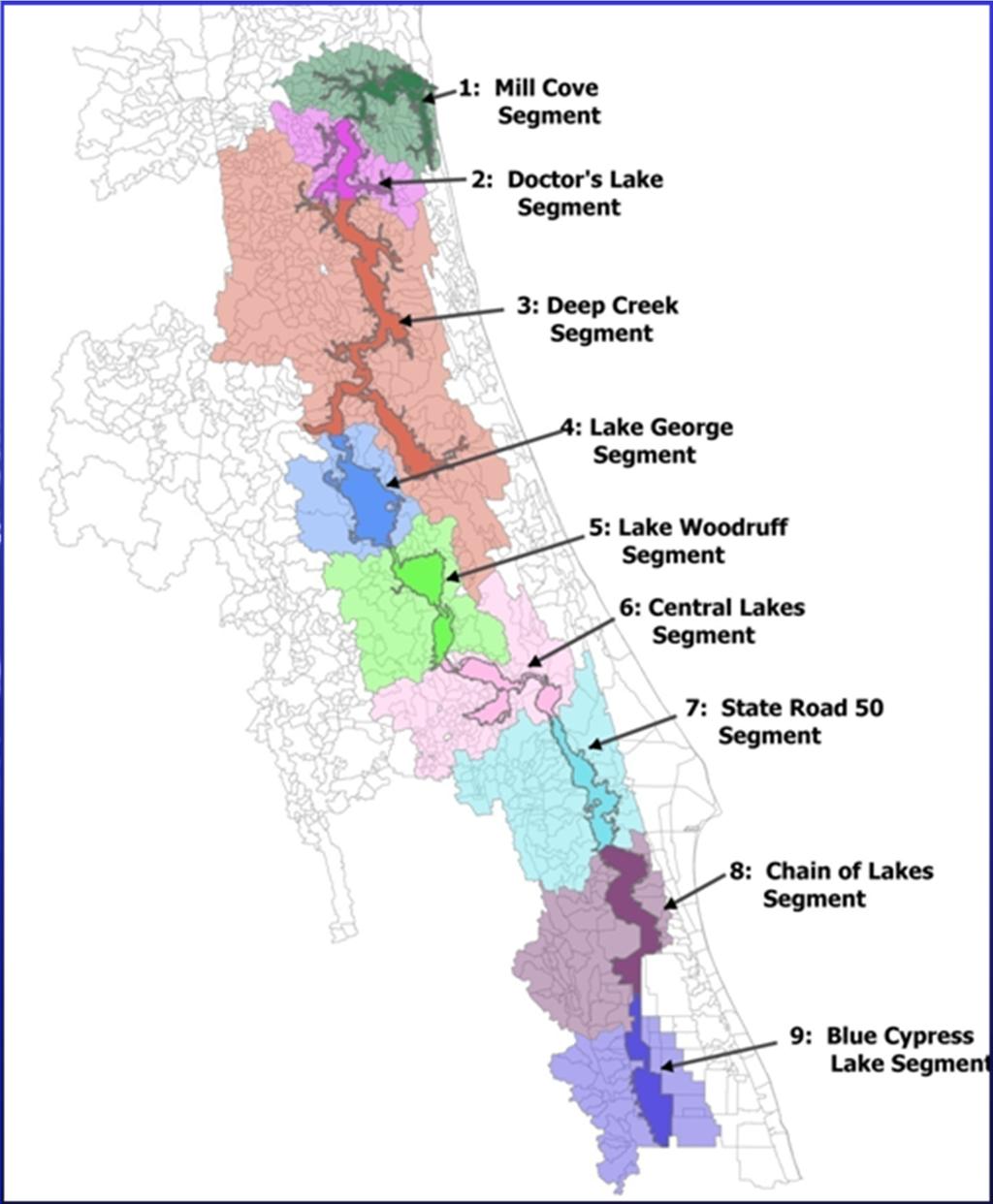
25 WSIS river segments
26 Ecological effects: Negligible to Minor effects for the two most likely scenarios. River Segment Hindcast 155 mgd Hindcast 77.5 mgd Forecast 262 mgd Forecast 155 mgd Forecast 77.5 mgd Negligible effect Minor effect Moderate effect Major effect Extreme effect WSIS - Results
27 Potential Uses of the New WSIS Models Evaluate specific water withdrawal proposals. Improve operation of District projects. Evaluate impacts of channel dredging Evaluate impacts of sea level rise. Using as foundation for enhanced water quality models - for loading and TMDLs.
Predicting Response of Small Marsh Fishes to Hydrologic Variation in the St. Johns River, Florida USA
 Predicting Response of Small Marsh Fishes to Hydrologic Variation in the St. Johns River, Florida USA Steven J. Miller, Lawrence Keenan, and Susan Connors Bureau of Environmental Sciences St. Johns River
Sea-Level Rise and Coastal Habitats in Southeastern Louisiana An Application of the SLAMM Model
 Sea-Level Rise and Coastal Habitats in Southeastern Louisiana An Application of the SLAMM Model Patty Glick (National Wildlife Federation) Jonathan Clough (Warren Pinnacle Consulting, Inc.) Amy Polaczyk
Exploring Localized Mixing Dynamics During Wet Weather in a Tidal Fresh Water System
 Exploring Localized Mixing Dynamics During Wet Weather in a Tidal Fresh Water System Ramona McCullough & Phil Duzinski Delaware Estuary Science & Environmental Summit January 27, 2015 Background and objectives
4.6 MODELING COASTAL RIVERS OPERATIONALLY: A CASE STUDY OF THE ST. JOHNS RIVER, FLA.
 4.6 MODELING COASTAL RIVERS OPERATIONALLY: A CASE STUDY OF THE ST. JOHNS RIVER, FLA. Reggina Cabrera Garza 1, Janice Sylvestre 2, and Michael Watts 2 1 NOAA, National Weather Service, Southeast River Forecast
Cumberland River Flood Preparedness Mapping and Products
 Cumberland River Flood Preparedness Mapping and Products Barry P. Moran, P.E. Hydraulic Engineer Nashville District September 2013 US Army Corps of Engineers BUILDING STRONG Authority: As a result of the
Hydrodynamic Modeling of Tides and Hurricane Storm Surge for Pre- and Post-Dredging Conditions in the Lower St. Johns River, Florida
 Hydrodynamic Modeling of Tides and Hurricane Storm Surge for Pre- and Post-Dredging Conditions in the Lower St. Johns River, Florida Matthew V. Bilskie 1 1 PhD Student, University of Central Florida, Department
Sussex County, DE Preliminary Study Overview
 Sussex County, DE Preliminary Study Overview Coastal study scope: 102 miles of entire County shoreline Revised 102 panels for coastal study Riverine study scope: 14 streams, 67.1 miles, within the Nanticoke
TROUT CREEK WATERSHED (Second Year of Snowline Data)
") Extent of Snow Cover During the 2002 Spring Freshet For the TROUT CREEK WATERSHED (Second Year of Snowline Data) (Penticton Forest District) 1.0 INTRODUCTION The extent of snow cover over a watershed basin
Extent of Snow Cover During the 2002 Spring Freshet For the TROUT CREEK WATERSHED (Second Year of Snowline Data) (Penticton Forest District) 1.0 INTRODUCTION The extent of snow cover over a watershed basin
USING A LABYRINTH WEIR TO INCREASE HYDRAULIC CAPACITY. Dustin Mortensen, P.E. 1 Jake Eckersley, P.E. 1
 USING A LABYRINTH WEIR TO INCREASE HYDRAULIC CAPACITY Dustin Mortensen, P.E. 1 Jake Eckersley, P.E. 1 Plum Creek Floodwater Retarding Structure No. 6 is located in an area of Kyle, Texas, that is currently
Proposed Reclassification of Muskrat Creek, North Platte River Basin in Goshen County, Wyoming
 Proposed Reclassification of Muskrat Creek, North Platte River Basin in Goshen County, Wyoming October 25, 2010 Waterbody: Muskrat Creek - Mainstem of Muskrat Creek from its headwaters downstream to its
Modeling of Oxygen Injection Experiment in Savannah Harbor
 593 Modeling of Oxygen Injection Experiment in Savannah Harbor S. Davie 1, H. Moorer 2, H. Rodriguez 1, Y. Plis 1 1 Tetra Tech, Inc., 2110 Powers Ferry Road, Suite 202, Atlanta, GA 30339, PH (770) 850-0949;
Louisiana s 2012 Coastal Master Plan BARRIER SHORELINE MORPHOLOGY MODEL
 Louisiana Coastal Protection & Restorat coastal.louisiana.gov Louisiana s 2012 Coastal Master Plan PREDICTIVE MODELING: committed to our coast BARRIER SHORELINE MORPHOLOGY MODEL Dallon Weathers, University
Changes in Fish Composition in an Eutrophic, Lacustrine River
 Changes in Fish Composition in an Eutrophic, Lacustrine River Lori McCloud St. Johns River Water Management District Russell Brodie, Florida Fish and Wildlife Conservation Commission Justin Solomon, Florida
What happens to Oregon s tidal wetlands with sea level rise?
 What happens to Oregon s tidal wetlands with sea level rise? Laura Brophy Estuary Technical Group Institute for Applied Ecology Corvallis, OR Laura@appliedeco.org Project maps future tidal wetlands, predicts
Case Studies. Georg Umgiesser and Natalja Čerkasova KU, Lithuania
 Case Studies Georg Umgiesser and Natalja Čerkasova KU, Lithuania Case 1: A beach in the Curonian Lagoon Beach Current situation in Curonian lagoon Beach in Kintai In the past, especially in Baltic inner
Water in the Deschutes Who needs it?
 Water in the Deschutes Who needs it? Rivers and streams over appropriation and flow alteration. Junior water right holders production agriculture. The Cities long-term supply for growing populations. Climate
Quantifying Performance of Stream Simulation Culverts in the Chehalis Basin, WA
 Quantifying Performance of Stream Simulation Culverts in the Chehalis Basin, WA AUTHORS: Joe Richards, Environmental Science Associates Jane Atha, Washington Department of Fish & Wildlife Colin Thorne,
Doug Leeper, Senior Environmental Scientist Resource Conservation and Development Department Southwest Florida Water Management District
 February 4, 2003 MEMORANDUM TO: FROM: SUBJECT: File Doug Leeper, Senior Environmental Scientist Resource Conservation and Development Department Southwest Florida Water Management District Proposed minimum
CATCHMENT HYDROLOGICAL RESPONSE TO CHANGING LAND SYSTEM IN KASHMIR HIMALAYA
 IGC, 2012 28 August, 2012 CATCHMENT HYDROLOGICAL RESPONSE TO CHANGING LAND SYSTEM IN KASHMIR HIMALAYA Prof. SHAKIL A ROMSHOO HEAD, DEPT OF EARTH SCIENCES KASHMIR UNIVERSITY PRESENTATION OVERVIEW KASHMIR
2 nd Steelhead Summit. October 27 & 28, 2016 in San Luis Obispo, CA
 + 2 nd Steelhead Summit October 27 & 28, 2016 in San Luis Obispo, CA 1 + Session Overview Sponsors: California Trout City of San Luis Obispo Sustainable Conservation California Conservation Corps Cachuma
UNDERSTANDING YOUR ESTUARY Level IA- ESTUARY SEARCH
 UNDERSTANDING YOUR ESTUARY Level IA- ESTUARY SEARCH Kakagon/Bad River Sloughs, a Lake Superior estuary located on the Bad River Reservation near Ashland, WI. GOAL Select one Wisconsin estuary to study
Modeling changes to the historic Lower Columbia River Estuary using Delft3D. Drew Mahedy Lumas Helaire Stefan Talke David Jay May 30, 2014
 Modeling changes to the historic Lower Columbia River Estuary using Delft3D Drew Mahedy Lumas Helaire Stefan Talke David Jay May 30, 2014 Comparison: Historic and Modern LCRE US Coastal Survey, 1868 Historic
Coastal Sediment Transport Modeling Ocean Beach & San Francisco Bight, CA
 1 Coastal Sediment Transport Modeling Ocean Beach & San Francisco Bight, CA Honghai Li and Lihwa Lin Engineering Research and Development Center U.S. Army Corps of Engineers Frank Wu, Lisa Andes, and James
APPENDIX C. Fluvial and Tidal Hydraulics Report
 APPENDIX C Fluvial and Tidal Hydraulics Report BUENA VISTA LAGOON ENHANCEMENT PROJECT FLUVIAL AND TIDAL HYDRAULICS ANALYSES Prepared for: SANDAG 401 B Street, Suite 800 San Diego, California 92101 Contact:
Ellis Y. Byeon, PE Bryan VanderGheynst, PE 1
 Ellis Y. Byeon, PE Bryan VanderGheynst, PE 1 Background Information: City of Trenton, Mercer County Assunpink Creek, Pond Run and Delaware River Lower 2.5 miles of the Assunpink Creek Lower 0.6 miles of
Council Member Dave Martin. April 17, 2018
 Council Member Dave Martin April 17, 2018 Plea for Three - SJRA Board Seats - Reduce pooling level at Lake Conroe from 201 feet above sea level to 198 feet above sea level - Dredging projects in San Jacinto
Wave Energy Research and Applications
 Wave Energy Research and Applications Shoreline and Shallows conference East Lansing, MI March 7, 2019 Photo: Dave Sanford Waves Background 1. Types of Waves 2. Good and Bad Waves 3. Restoration Impacts
Enclosure 16. Memorandum for Record Informal Consultation Telecon 12 March 2004
 Enclosure 16 Memorandum for Record Informal Consultation Telecon 12 March 2004 MEMORANDUM FOR RECORD 1. On Tuesday, 9 March 2004, the US Army Corps of Engineers, Mobile District, Water Management Section
Trout Unlimited Comments on the Scope of Environmental Impact Statement for the Constitution Pipeline Project, Docket No. PF12-9
 October 9, 2012 Kimberly D. Bose, Secretary Federal Energy Regulatory Commission 888 First Street, NE, Room 1A Washington, DC 20426 RE: Trout Unlimited Comments on the Scope of Environmental Impact Statement
Aquatic Biological Assessment. Lassen 15 Restoration Project. Modoc National Forest Warner Mountain Ranger District
 Aquatic Biological Assessment Lassen 15 Restoration Project Modoc National Forest Warner Mountain Ranger District Prepared By:_/s/ Marty Yamagiwa Date: December 10, 2015 Marty Yamagiwa, Natural Resources
Case Studies Georg Umgiesser and Natalja Čerkasova KU, Lithuania
 Case Studies Georg Umgiesser and Natalja Čerkasova KU, Lithuania Case 1: A beach in the Curonian Lagoon 1 Beach Current situation in Curonian lagoon Beach in Kintai In the past, especially in Baltic inner
US Sugar Land Purchase, River of Grass Project, SugarHill Sector Plan, Amendment 1
 US Sugar Land Purchase, River of Grass Project, SugarHill Sector Plan, Amendment 1 Rivers Coalition September 24, 2014 Upper Chain of Lakes Lake Kissimmee Kissimmee River Caloosahatchee Estuary Lake Okeechobee
Florida Seagrass Integrated Mapping and Monitoring Program
 Florida Seagrass Integrated Mapping and Monitoring Program - 2004 The following document is composed of excerpts taken from the 2011 publication, Seagrass Integrated Mapping and Monitoring for the State
Plan B Dam Breach Assessment
 Plan B Dam Breach Assessment Introduction In support of the Local Sponsor permit applications to the states of Minnesota and North Dakota, a dam breach analysis for the Plan B alignment of the Fargo-Moorhead
1.Mill Creek Watershed Summary Description and Land Use
 1.Mill Creek Watershed Summary Description and Land Use Table xxx: Mill Creek Watershed Overview Watershed Size 31,435 acres/49.1 sq miles/ 127.1 sq km Elevation Range 5,594 feet [4,967-10,561] Stream
Klickitat County Shoreline Master Program Update. Open House March 15, 2017
 Klickitat County Shoreline Master Program Update Open House March 15, 2017 Agenda 6:00 6:10 Welcome 6:10 6:40 Presentation SMP Update Process Shoreline Analysis review 6:40 8:00 Open House Topics SMP Process
Hydrologic Feasibility of Storm Surge Barriers
 Hydrologic Feasibility of Storm Surge Barriers Malcolm J. Bowman, School of Marine and Atmospheric Sciences State University of New York, Stony Brook, NY. Presented at Against the Deluge: Storm Surge Barriers
Tidal regime along Vietnam coast under impacts of sea level rise
 VNU Journal of Science, Earth Sciences 28 (2012) 133-139 Tidal regime along Vietnam coast under impacts of sea level rise Tran Thuc, Duong Hong Son* Vietnam Institute of Meteorology, Hydrology and Environment
Analysis Data Sources
 Page Technical Appendix D 1 SMP Analysis Data Sources the set bathymetry levee riprap mine lakebath_arc FloodHazardD ata.mdb\flood HazardZoneCo mponents\fhcl evee FloodHazardD ata.mdb\flood HazardZoneCo
PROFILE OF SACRAMENTO RIVER, FREEPORT TO VERONA, CALIFORNIA,
 PROFILE OF SACRAMENTO RIVER, FREEPORT TO VERONA, CALIFORNIA, FLOOD OF FEBRUARY 1986 By J.C. Blodgett and J.B. Lucas U.S. GEOLOGICAL SURVEY Open-File Report 88-82 CO CM I m r-h CM Sacramento, California
Future Condi,ons coastal hazard modeling and mapping
 Future Condi,ons coastal hazard modeling and mapping Presented by Bob Ba:alio, PE Environmental Science Associates, Inc. (ESA) On behalf of the physical processes team (USGS, TerraCosta- Scripps, ESA)
Importance of un-named tributary streams to Brook Trout populations. Dr. Jonathan M. Niles Dr. Dan Ressler
 Importance of un-named tributary streams to Brook Trout populations. Dr. Jonathan M. Niles Dr. Dan Ressler Pennsylvania Streams All streams of PA have a designated use - Huge resource - 8,011 named tributaries:
Simulating Streams Through Culverts in Mat-Su, Alaska
 Simulating Streams Through Culverts in Mat-Su, Alaska Project Managers Bill Rice, P.E., USFWS Hydrologist Mary Price, USFWS Fishery Biologist The Team Approach US Fish and Wildlife Service Bill Rice, P.E.,
STREAM SURVEY File form No..
 scanned for KRIS THE RESOURCES AGENCY OF CALIFORNIA California Department of Fish and Game STREAM SURVEY File form No.. Date: September 4, 1969. NAME: North Fork Schooner Gulch Creek COUNTY: Mendocino.
City of Del Mar Local Coastal Plan (LCP) Amendment for Sea Level Rise and Coastal Flooding
 Amendment for Sea Level Rise and Coastal Flooding") City of Del Mar Local Coastal Plan (LCP) Amendment for Sea Level Rise and Coastal Flooding 6/22/17 Presentation to Sea Level Rise Stakeholder- Technical Advisory Committee (STAC) Nick Garrity, P.E. Lindsey
City of Del Mar Local Coastal Plan (LCP) Amendment for Sea Level Rise and Coastal Flooding 6/22/17 Presentation to Sea Level Rise Stakeholder- Technical Advisory Committee (STAC) Nick Garrity, P.E. Lindsey
SECTION 2 HYDROLOGY AND FLOW REGIMES
 SECTION 2 HYDROLOGY AND FLOW REGIMES In this section historical streamflow data from permanent USGS gaging stations will be presented and discussed to document long-term flow regime trends within the Cache-Bayou
Environmental Review and Permitting for Wild Trout
 Environmental Review and Permitting for Wild Trout Tom Shervinskie Wild Trout Summit Watershed Analysis Section August 26, 2017 Division of Environmental Services The mission of the Pennsylvania Fish and
Trout behavior and responses to pulsed flows: investigations utilizing electromyogram telemetery
 Trout behavior and responses to pulsed flows: investigations utilizing electromyogram telemetery Sarah A. Hamilton, Dennis E. Cocherell, Gardner J. Jones, and Javier B. Miranda, A. Peter Klimley, Lisa
Aspects and Case Studies of the Effects of Climate Change on Water Resources. Part II (Case Studies)
") Aspects and Case Studies of the Effects of Climate Change on Water Resources Part II (Case Studies) Manfred Koch Department of Geohydraulics and Engineering Hydrology, University of Kassel, Germany Email:
Aspects and Case Studies of the Effects of Climate Change on Water Resources Part II (Case Studies) Manfred Koch Department of Geohydraulics and Engineering Hydrology, University of Kassel, Germany Email:
Wave energy converter effects on wave and sediment circulation
 Wave energy converter effects on wave and sediment circulation Grace Chang and Craig Jones Integral Consulting Inc. cjones@integral-corp.com; gchang@integral-corp.com Jesse Roberts, Kelley Ruehl, and Chris
APPENDIX H LAKE OKEECHOBEE FLOOD ROUTINES
 1 2 3 APPENDIX H LAKE OKEECHOBEE FLOOD ROUTINES 1 2 3 4 5 6 7 8 9 10 11 12 13 14 15 16 17 18 19 20 21 22 23 24 25 26 27 28 29 30 31 32 33 34 35 36 37 38 39 40 41 42 43 44 45 LAKE OKEECHOBEE FLOOD ROUTINGS
FINAL REPORT. Yonkers Creek Migration Barrier Removal Project Wonderstump Road Del Norte County. Submitted By:
 FINAL REPORT Yonkers Creek Migration Barrier Removal Project Wonderstump Road Del Norte County Submitted By: Del Norte County Community Development Department Yonkers Creek Migration Barrier Removal Project
The Cumulative Impacts of Shoreline Armoring on Forage Fish Spawning Habitat in San Juan County, Washington
 Western Washington University Western CEDAR Salish Sea Ecosystem Conference 2014 Salish Sea Ecosystem Conference (Seattle, Wash.) May 1st, 1:30 PM - 3:00 PM The Cumulative Impacts of Shoreline Armoring
APPENDIX D W-19 FLUVIAL AND TIDAL HYDRAULIC, SEDIMENTATION, WATER QUALITY AND SEA LEVEL RISE MODELING STUDIES
 APPENDIX D W-19 FLUVIAL AND TIDAL HYDRAULIC, SEDIMENTATION, WATER QUALITY AND SEA LEVEL RISE MODELING STUDIES Final EIR November 2018 Appendices Executive Summary Background: The San Dieguito Lagoon W19
Performance of three Selected Convective Schemes for Predicting Indian Summer Monsoon Rainfall using RegCM4.4
 Performance of three Selected Convective Schemes for Predicting Indian Summer Monsoon Rainfall using RegCM4.4 A.K.M. Saiful Islam Professor Institute of Water and Flood Management Bangladesh University
U.S. Fish and Wildlife Service Stream Habitat Improvement Projects
 U.S. Fish and Wildlife Service Stream Habitat Improvement Projects Melanie Car ter and Corey Kanuckel U.S. Fish & Wildlife Service Partners for Fish & Wildlife (PFW) Stream Team: Drew Langston Hunter Kittrell
Upper Iroquois River atershed Management Plan
 2013 Upper Iroquois River atershed Management Plan Daniel M Perkins Jasper County Soil and Water Conservation District 12/30/2013 Table of Contents 1.1 WATERSHED COMMUNITY INITIATIVE... 12 1.2 Project
ELK RIVER WATERSHED ACTION PLAN
 ELK RIVER WATERSHED ACTION PLAN Prepared for The Elk River Watershed Council Prepared by Chris Massingill Mainstream Contracting South Coast Watershed Council September 2001 South Coast Watershed Council
Proposed Reclassification of Cherry Creek, North Platte River Basin, Wyoming. October 25, 2010
 Proposed Reclassification of Cherry Creek, North Platte River Basin, Wyoming October 25, 2010 Waterbody: Location: Tributary to: Cherry Creek - Mainstem from headwaters downstream to the confluence with
Illinois State Water Survey
 Illinois State Water Survey HYDROLOGY DIVISION SWS Contract Report 508 COMPARISON OF 1987 AND 1989 BED PROFILE SURVEYS OF THE LOWER CACHE RIVER by Richard Allgire Office of Sediment and Wetland Studies
Kissimmee River Channelization
 Environmental Restoration ti Update Phil Flood, South Florida Water Management District Presentation Overview Kissimmee River Restoration Everglades Stormwater Treatment Areas Comprehensive Everglades
3. The qualification raised by the ISRP is addressed in #2 above and in the work area submittal and review by the ISRP as addressed in #1.
 Please find attached a response from The Confederated Tribes of the Warm Springs Reservation of Oregon (CTWSRO) for Project # 2008-301-00, Habitat Restoration Planning, Design and Implementation within
September 27, 2012 MEMORANDUM. Fish and Wildlife Committee. Lynn Palensky. Update on Geographic Review
 Rhonda Whiting Chair Montana Bruce A. Measure Montana James A. Yost Idaho W. Bill Booth Idaho Bill Bradbury Vice-Chair Oregon Henry Lorenzen Oregon Tom Karier Washington Phil Rockefeller Washington September
A Comparison of Western Watershed Councils. Presentation Prepared by Jeff Salt, Great Salt Lakekeeper
 A Comparison of Western Watershed Councils Presentation Prepared by Jeff Salt, Great Salt Lakekeeper Presentation Overview Introduction Jordan River Watershed Council Lower Boise Watershed Council Clackamas
January 4, Addresses water quality within the Council program.
 Phil Rockefeller Chair Washington Tom Karier Washington Henry Lorenzen Oregon Bill Bradbury Oregon W. Bill Booth Vice Chair Idaho James Yost Idaho Pat Smith Montana Jennifer Anders Montana January 4, 2016
SPO Regional Challenge Grant Creation of a Sea Level Adaption Working Group for Biddeford, Saco, OOB and Scarborough J.T. Lockman, AICP, Planning
 SPO Regional Challenge Grant Creation of a Sea Level Adaption Working Group for Biddeford, Saco, OOB and Scarborough J.T. Lockman, AICP, Planning Director Southern Maine Regional Planning Commission jlockman@smrpc.org
Climate Change Adaptation and Stream Restoration. Jack Williams;
 Climate Change Adaptation and Stream Restoration Jack Williams; jwilliams@tu.org 1 Goals for this presentation Develop strategies for adapting streams to climate impacts by Thinking like a watershed Understanding
Impact of Dredging the Lower Narrow River on Circulation and Flushing
 Impact of Dredging the Lower Narrow River on Circulation and Flushing Craig Swanson Ph.D. Swanson Environmental Alex Shaw Ocean Engineering, URI Prof. Malcolm L. Spaulding Ocean Engineering, URI 29 January
One Truckee River Sparks City Council
 One Truckee River Sparks City Council What is the One Truckee River initiative? Working together for a sustainable, clean, thriving river community recognized in the hearts and minds of all for the treasure
Interim Response of Wading Birds and Waterfowl to the Kissimmee River Restoration Project
 Interim Response of Wading Birds and Waterfowl to the Kissimmee River Restoration Project Michael Cheek Environmental Scientist, Applied Science Bureau, South Florida Water Management District Photo: Kissimmee
Boothbay Harbor Rotary Club May 12, 2016
 Mapping Potential Sea Level Rise and Storm Surge in Boothbay Harbor, ME Boothbay Harbor Rotary Club May 12, 2016 Peter A. Slovinsky, Marine Geologist Maine Geological Survey S.M. Dickson, MGS Quickly,
FINAL HARRIS CHAIN OF LAKES RESTORATION COUNCIL SITE VISIT SUMMARY. of the. Projects Tour March 3, 2006
 FINAL HARRIS CHAIN OF LAKES RESTORATION COUNCIL SITE VISIT SUMMARY of the Projects Tour March 3, 2006 The regular meeting of the Harris Chain of Lakes Restoration Council (Council) was cancelled to facilitate
Climate Change and Hydrology in the Sierra Nevada. Lorrie Flint U.S. Geological Survey Sacramento CA
 Climate Change and Hydrology in the Sierra Nevada Lorrie Flint U.S. Geological Survey Sacramento CA Discussion Topics Climate change for California Methods to evaluate hydrologic impacts Water balance
FWCP External Projects Delivered by Stakeholders and First Nations
 FWCP External Projects Delivered by Stakeholders and First Nations 2013-2014 For more information contact FWCP-Columbia program manager, Trevor Oussoren Trevor.oussoren@bchydro.com 250-365-4551 2013-2014
Response of a Newly Created Marsh-Wetland Affected by Tidal Forcing, Upland Discharge, and Groundwater Interaction
 Response of a Newly Created Marsh-Wetland Affected by Tidal Forcing, Upland Discharge, and Groundwater Interaction Mouth of Columbia River, Cape Disappointment State Park, Washington 12 Hans R. Moritz
NUMERICAL AND PHYSICAL MODELING
 POINTE DU BOIS GENERATING STATION SPILLWAY REPLACEMENT PROJECT NUMERICAL AND PHYSICAL MODELING Kara Hurtig, Northwest Hydraulic Consultants, North Vancouver, BC, Canada David S. Brown, KGS Group, Winnipeg,
Training program on Modelling: A Case study Hydro-dynamic Model of Zanzibar channel
 Training program on Modelling: A Case study Hydro-dynamic Model of Zanzibar channel Mayorga-Adame,C.G., Sanga,I.P.L., Majuto, C., Makame, M.A., Garu,M. INTRODUCTION Hydrodynamic Modeling In understanding
Lower Saluda Scenic River Advisory Council
 Saluda Hydro Project, FERC Project No. 516: Comments on ICD Page 1 of 10 Lower Saluda Scenic River Advisory Council c/o South Carolina Department of Natural Resources 1000 Assembly Street, Suite 354, Columbia,
E-3: Jurisdictional Determination Supplement Report
 Lake Ralph Hall Appendix E E-3: Jurisdictional Determination Supplement Report P.O. Drawer 305 Lewisville, TX 75067 REGIONAL WATER DISTRICT (972)219-1228 Fax(972)221-9896 June 22, 2017 Mr. Chandler Peter
2008 Florida Alligator Hunting Survey Report
 2008 Florida Alligator Hunting Survey Report The Alligator Management Program of the Florida Fish and Wildlife Conservation Commission surveyed alligator hunters that were permitted in 2008 to gather information
CENTRAL PROJECT: PLANNING EVERGLADES CENTRAL EVERGLADES RESTORING THE HEART OF THE EVERGLADES
 CENTRAL EVERGLADES PLANNING PROJECT: PRESENTED BY Gina Paduano Ralph, Ph.D. U.S. Army Corps of Engineers Jacksonville District Guy Carpenter Florida Fish and Wildlife Conservation Commission APRIL 2014
LOCAL COASTAL PROGRAM UPDATE
 LOCAL COASTAL PROGRAM UPDATE Agenda Meeting #1 General Information (1 1:45 pm) Introductions and Background Grants involved What is a Local Coastal Program? What is required? LCP Update tasks and schedule
FISHERIES IMPACT ASSESSMENT
 FISHERIES IMPACT ASSESSMENT 2 Key strategic question To what extent can mainstream dams alter fish biodiversity, fish migration patterns and fish catches in the Mekong aquatic systems? Outline 1- Baseline
Leaning Into Adaptation
 www.marinslr.org Leaning Into Adaptation GFNMS Ocean Summit, May 17, 2016 Jack Liebster, Planning Manager, Marin County Marin County C-SMART Sea Level Rise Adaptation Process Evaluate Science Info. Implement
LAKE JESUP VEGETATION MAPPING: AN INTER-AGENCY COLLABORATION. Lakshmi Sankaran, GISP Public Works Department, Seminole County
 LAKE JESUP VEGETATION MAPPING: AN INTER-AGENCY COLLABORATION Lakshmi Sankaran, GISP Public Works Department, Seminole County LAKE JESUP Area - 12 sq miles Shoreline - 53 miles Watershed - 136 sq miles
CITY OF ALPHARETTA DOWNTOWN MASTER PLAN TRAFFIC EVALUATION
 CITY OF ALPHARETTA DOWNTOWN MASTER PLAN TRAFFIC EVALUATION June 2015 CITY OF ALPHARETTA DOWNTOWN MASTER PLAN TRAFFIC EVALUATION Introduction The Alpharetta Downtown Master Plan was developed in the fall
Enclosure 9. Memorandum for Record, meeting with FWS on August 12, 2002
 Enclosure 9 Memorandum for Record, meeting with FWS on August 12, 2002 CESAM-PD-EI Brandt/690-3260/23 August 2002 MEMORANDUM FOR RECORD SUBJECT: Meeting with USFWS and FWCC to Discuss ACF Water Control
Public Notice. Corps File No. LRE Date: March 19, 2017 Expires: March 18, 2022
 US Army Corps of Engineers Detroit District Public Notice Corps File No. LRE-2016-00006-100 Date: March 19, 2017 Expires: March 18, 2022 PUBLIC NOTICE ANNOUNCING REGIONAL CONDITIONS AND WATER QUALITY CERTIFICATIONS
Illinois Lake Management Association Conference March 23, 2018 By Trent Thomas Illinois Department of Natural Resources Division of Fisheries
 Illinois Lake Management Association Conference March 23, 2018 By Trent Thomas Illinois Department of Natural Resources Division of Fisheries Sources of Habitat Impairment Sedimentation Channelization
MUCKLESHOOT INDIAN TRIBE Fisheries Division nd Avenue SE Auburn, Washington Phone: (253) Fax: (253)
 Fax: (253)") MUCKLESHOOT INDIAN TRIBE Fisheries Division 39015-172nd Avenue SE Auburn, Washington 98092-9763 Phone: (253) 939-3311 Fax: (253) 931-0752 U.S. Army Corps of Engineers Regulatory Branch Attn: Karen Urelius
MUCKLESHOOT INDIAN TRIBE Fisheries Division 39015-172nd Avenue SE Auburn, Washington 98092-9763 Phone: (253) 939-3311 Fax: (253) 931-0752 U.S. Army Corps of Engineers Regulatory Branch Attn: Karen Urelius
Applications of ELCIRC at LNEC
 stratification in the Guadiana estuary tidal propagation in the Óbidos lagoon Lígia Pinto Anabela Oliveira André B. Fortunato 2 O utline Stratification in the Guadiana estuary The Guadiana estuary Objectives
California Steelhead: Management, Monitoring and Recovery Efforts
 California Steelhead: Management, Monitoring and Recovery Efforts Jonathan Nelson Steelhead Management, Research and Restoration Program Oncorhynchus mykiss irideus California Steelhead - Hot Topics Implementation
Hydrological Condition Report including the issues of High Flow Fluctuation in Chiang Saen
 Hydrological Condition Report including the issues of High Flow Fluctuation in Chiang Saen Technical Symposium for ESCIR and MRC on Social Impact Assessment in River Basin Management Sothea KHEM, HENG
FINAL Caples Lake Fisheries Management Plan. Version 4.0
 FINAL Caples Lake Fisheries Management Plan Version 4.0 August 15, 2008 Purpose The Caples Lake Fisheries Management Plan (Plan) outlines the stocking plan to reestablish a sport fishery in Caples Lake
Assessment of Baseline Geomorphic Features at. Proposed Stream Crossings On The Proposed County Road 595. Marquette County, Michigan
 Assessment of Baseline Geomorphic Features at Proposed Stream Crossings On The Proposed County Road 595 Marquette County, Michigan Prepared for: Kennecott Eagle Minerals Company Marquette, Michigan Prepared
SHORE PROTECTION AND HABITAT CREATION AT SHAMROCK ISLAND, TEXAS ABSTRACT
 SHORE PROTECTION AND HABITAT CREATION AT SHAMROCK ISLAND, TEXAS M. Cameron Perry, P.E., and Daniel J. Heilman, P.E. Coastal Engineer Shiner Moseley & Associates., Inc. 555 N. Carancahua Corpus Christi,
CHAPTER 8 ASSESSMENT OF COASTAL VULNERABILITY INDEX
 124 CHAPTER 8 ASSESSMENT OF COASTAL VULNERABILITY INDEX 8.1 INTRODUCTION In order to assess the vulnerability of the shoreline considered under this study against the changing environmental conditions,
Little Spokane River Stream Gage Report: Deadman Creek, Dragoon Creek, and the West Branch of the Little Spokane River
 Little Spokane River Stream Gage Report: Deadman Creek, Dragoon Creek, and the West Branch of the Little Spokane River June 2010 Spokane County Conservation District N. 210 Havana St. Spokane, WA 99202
Total Suspended Solids, Stable Flow, and Wet Weather Event Monitoring in the Bass River Watershed. December The Cadmus Group, Inc.
 Total Suspended Solids, Stable Flow, and Wet Weather Event Monitoring in the Bass River Watershed December 2004 The Cadmus Group, Inc. Grand Valley State University Annis Water Resources Institute Submitted
HEC-RAS Two-Dimensional Modeling: Lake Wausau, Wisconsin River and Tributaries Big Rib River and Eau Claire River January 2018
 Final Report HEC-RAS Two-Dimensional Modeling: Lake Wausau, Wisconsin River and Tributaries Big Rib River and Eau Claire River City of Schofield, City of Wausau, Town of Rib Mountain, and Village of Rothschild,