Ongoing Research at the USACE Field Research Facility Jeff Waters, PhD Chief, Coastal Observations & Analysis Branch Coastal & Hydraulics Lab
|
|
|
- Sherilyn Hutchinson
- 5 years ago
- Views:
Transcription


1 Ongoing Research at the USACE Field Research Facility Jeff Waters, PhD Chief, Coastal Observations & Analysis Branch Coastal & Hydraulics Lab


2 Coastal and Hydraulics Laboratory Who We Are CHL is the only federal laboratory dedicated solely for coastal and hydraulic research. Our multi-disciplinary team addresses challenges ranging from groundwater to coastal inlets. More than three-quarters of the laboratory s engineers and scientists hold advanced degrees, contributing to the production of successful coastal and inland water resources solutions.
3 Navy Duck Rocket and Target Range
4 FRF: 1 st Two Decades ( ) DUCK-X 1978 ARSLOE 1980 ASEX 1981 DUCK82 DUCK85 SUPERDUCK 1986 DELILAH 1990 DUCK94 RIP 1996 SANDYDUCK 97 SHOWEX NDBC 46m


 8m Array Dune LIDAR Aquadopp 2.")
5 FRF Wave Arrays 8m-Array 1986 present 15 Bottom mounted pressure gauges High directional-resolution Iterative Maximum Likelihood Estimator for wave direction Unique for long-term waves measurements Cross-Shore Array 2008-present Cross-shore measurements of wave transformation Nearshore: 3 buried Paros pressure sensors and 3 AWAC gauges, 3 co-located altimeters 11m Awac 3 offshore buoys LIDAR runup and setup 11m Awac Cross-shore Array Buoys: 17m WaveRider (3.2 km) 26m Waverider (17 km) 46m NDBC (95 km) 8m Array Dune LIDAR Aquadopp 2.5m AWACs 4.5, 6, 11m WaveriderS 17 m & 26 m NDBC 46m
; 10m tall, real time kinematic global positioning system (RTK-GPS), motion sensor (pitch and roll) Lighter Amphibious Resupply Cargo (LARC); Digital")
 Results: The two systems compared well; mean difference of ~ 1cm along profile line, RMS error 3.1cm. Re-evaluate systems during more adverse wave conditions")
6 Nearshore Survey System Evaluation Evaluate the accuracy of the LARC vs CRAB for surveying the beach and nearshore Survey systems: Coastal Research Amphibious Buggy (CRAB); 10m tall, real time kinematic global positioning system (RTK-GPS), motion sensor (pitch and roll) Lighter Amphibious Resupply Cargo (LARC); Digital echosounder, RTK-GPS, motion sensor (heave, pitch, and roll) PIs: Mike Forte & Rob Mitchell Field test: repetitively survey two profile lines (4 times by CRAB, 9 times by LARC) Results: The two systems compared well; mean difference of ~ 1cm along profile line, RMS error 3.1cm. Re-evaluate systems during more adverse wave conditions


")
7 Field Research Facility Data Integration Framework FDIF FRF Data Portal Version 2.0 PI: Mike Forte Provides near real time data access for a variety of coastal observations and data access for implementation of Coastal Model Test Bed General plotting and statistics for user defined time periods covering (1980 current) Tools for statistically comparing two datasets (i.e. observed vs. modeled)


8 Coastal Model Test Bed PI: Spicer Bak Purpose: Automated evaluation of coastal numerical models in near real-time utilizing FRF data to: assess model parameterizations in range of conditions Identify poorly resolved model physics provide framework to develop data assimilation techniques Models: STWAVE Operational CMS Under Development CSHORE FY 17


9 Nearshore Processes PIs: Bradley Johnson, Spicer Bak, Patrick Dickhudt, Katherine Brodie Expand real-time altimeter array to improve morphologic modeling capability (CSHORE) Incorporate CSHORE into CMTB Multi-program effort Flood & Coastal CODS CIRP Existing Summer 2017


 laser data 0.8 0.6 0.4 0.2 0-0.")
10 FRF Terrestrial Lidar Research Dune Erosion during Storms Surf-zone wave shapes improve basic physics of wave-driven sediment transport Beach Morphological Evolution collect critical data for improved predictions Wave Runup & Swash Hydrodynamics data available in near-realtime for model evaluation Elevation (m, NAVD88) high-spatial & temporal 3D data sets (hourly) Wave time-series paros raw laser filtered (f<0.5hz) and averaged (0.5s) laser data :04:30 08:04:45 08:05:00 08:05:15 08:05:30 08:05:45 08:06:00 08:06:15
 Adapt technology developed in academia to make quantitative coastal")


11 Video Imaging for Coastal Monitoring GOAL: Transition nearshore video imagery R&D (ARGUS) for District use over the next 5 years (SoN submitted:2017-n-66) Adapt technology developed in academia to make quantitative coastal observations to provide USACE districts with an improved capability to monitor coastal projects from both stationary & mobile UAS platforms Improve accessibility to Argus community through online code repositories, boot-camps, increased visibility, and development of an international Coastal Imaging Research Network Identify ways to utilize coastal monitoring data to calibrate USACE numerical models Video observations of breaking waves can be used to map the shoreline and sandbar morphology UAVs are an accessible platform from which these data can be collected don t need a tower any more! Video observations of wave speeds can be used to calculate water depth


12 FRF UAS & Video Imaging Research Merged Topo-Bathy Identifying UAS Applications to Support Flood Risk Management Needs Survey & Mapping Infrastructure Assessment Environmental Monitoring PI: Kate Brodie Evaluation of existing platforms & capabilities in Duck, NC Compare/contrast a wide array of sensors, platforms, and data processing methodologies to assess capabilities Particular focus on uncertainty & error propagation Identify ways to integrate data with USACE numerical models
")
 Beach Surveys Performed: Quarterly")

13 Coastal Lidar and Radar Imaging System(CLARIS) Multi-Sensor Mobile Surveying System: Lidar-based topography measurements Radar-based wave speed measurements bathymetry inversion Spherical camera for colorizing topography measurements (FY 17) Vehicle Platform Upgrade: 4WD passenger van all components reside inside cabin other than active sensors Safer and more reliable for driver and operator Upgraded instrumentation and processing algorithms (FY 17) Beach Surveys Performed: Quarterly (20 km centered around FRF) Pre/During/Post-Storms Upcoming municipalities beach nourishment (FY 17) Observational Data are Critical For: Field verification of numerical models predicting alongshore variations in dune morphological response to extreme storms dune swash sandba
 Short Term Evolution")


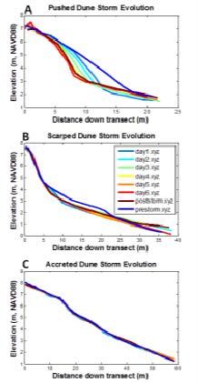
14 Dune Research at the FRF Focused on understanding the eco-geomorphological feedbacks that contribute to a coastal foredune s system resiliency (as outlined in ERDC SR-15-1 as NNBF) Short Term Evolution Utilizes high-resolution terrestrial lidar monthly surveys of three dune sites with different geometry o Steeply-scarped dune o Wide, hummocky dune o Human-modified dune Wind, wave and precipitation observations provide forcing on system Elevation measurements quantify the erosion and accretion response at the centimeter scale Response phenomena magnitude assessed for various geometry Long Term Evolution Probablistic model will be trained on the FRF s 30-year record of wind, waves, and topography Identify which variables are the most important for encouraging resilience during periods of dune growth/erosion.


15 Radar Inlet Observing System (RIOS) PI: Jesse McNinch RIOS utilizes X-band radar to measure wave breaking and wave speed. Wave observations are then used to calculate depths through bathymetry inversion and scaling. These measurements are particularly suited to determine the location of channels and shoals across shallow, coastal environments such as tidal inlets. Raw Data RIOS-derived bathymetry System Requirements Range of measurements are limited to within 3km of the RIOS antenna Field site must have waves present (not conducive for small lakes or rivers) A single X-band rotation showing high intensity returns on incident waves. Depth scaling models relating radar intensity to measured depths Bathymetric depth chart generated hourly. Navigation Routes and Conditions Product List RIOS provides the following products hourly: ascii data file of estimated depths across domain wave conditions along an identified navigation route time-averaged (detided) georectified image of wave breaking conditions that identifies shoals across the domain Time-average of radar intensity over a 10min collection. Vessel wakes measured by RIOS identify navigation route. Wave conditions along navigation route. shoreline and shoal position within domain


16 Currituck Sound Array 1. Long-term estuarine observatory 2. 5 stations providing real-time hydrodynamic, water quality, and meteorologic data. CSA 03 Standard measurements Water level Waves / Currents Wind Turbidity Salinity / Temperature At select stations Light attenuation fdom Chlorophyll ph Dissolved Oxygen Bed elevation CSA 04 CSA 02 CSA 05 FRF CSA 01


17 Nearshore Geophysics: Geologic Framework PIs: Heidi Wadman and Jesse McNinch Examples of Engineering Needs: - Identification of offshore/nearshore variations in sediment type and thickness (often related to shoreline change) - Identification of sand resources/habitat/cultural resources - Rapid mapping of the local geologic framework (identification of geologic controls on scour, shoreline erosion, etc.) minimizes need for expensive boreholes. Observational Data are Critical For: - Improved modeling of sediment transport, short- and longterm shoreline erosion, and morphology change) - Increasing accuracy of shoreline stability predictions
18 Questions?
Pathways Interns: Annika O Dea, Ian Conery, Andrea Albright
 1 REMOTE SENSING OF COASTAL MORPHODYNAMICS 237 237 237 217 217 217 2 2 2 8 119 27 252 174.59 255 255 255 163 163 163 131 132 122 239 65 53 11 135 12 112 92 56 62 12 13 12 56 48 13 12 111 Kate Brodie Brittany
Analysis of Wave Predictions from the Coastal Model Test Bed using cbathy
 Analysis of Wave Predictions from the Coastal Model Test Bed using cbathy Spicer Bak, Ty Hesser, Jane Smith U.S. Army Engineer Research & Development Center Duck, NC Coastal Model Test Bed Purpose: Automated
Coastal Wave Energy Dissipation: Observations and Modeling
 Coastal Wave Energy Dissipation: Observations and Modeling Jeffrey L Hanson US Army Corps of Engineers Field Research Facility USACE Field Research Facility Kent K. Hathaway US Army Corps of Engineers
An IOOS Operational Wave Observation Plan Supported by NOAA IOOS Program & USACE
 An IOOS Operational Wave Observation Plan Supported by NOAA IOOS Program & USACE R.E. Jensen, W.A. Birkemeier and W. Burnett JCOMM-Workshop on Wave Measurements from Buoys Wave Information to Application
Beach Wizard: Development of an Operational Nowcast, Short-Term Forecast System for Nearshore Hydrodynamics and Bathymetric Evolution
 Beach Wizard: Development of an Operational Nowcast, Short-Term Forecast System for Nearshore Hydrodynamics and Bathymetric Evolution Ad Reniers Civil Engineering and Geosciences, Delft University of Technology
Wave Transformation and Setup from a Cross-shore Array of Acoustic Doppler Profilers (Poster)
") Wave Transformation and Setup from a Cross-shore Array of Acoustic Doppler Profilers (Poster) Kent K. Hathaway and Jeffrey L. Hanson Introduction US Army Corps of Engineers Field Research Facility, Kitty
Wave Transformation and Setup from a Cross-shore Array of Acoustic Doppler Profilers (Poster) Kent K. Hathaway and Jeffrey L. Hanson Introduction US Army Corps of Engineers Field Research Facility, Kitty
WAVE BREAKING AND DISSIPATION IN THE NEARSHORE
 WAVE BREAKING AND DISSIPATION IN THE NEARSHORE LONG-TERM GOALS Dr. Thomas C. Lippmann Center for Coastal Studies Scripps Institution of Oceanography University of California, San Diego 9500 Gilman Dr.
Prediction of Nearshore Waves and Currents: Model Sensitivity, Confidence and Assimilation
 Prediction of Nearshore Waves and Currents: Model Sensitivity, Confidence and Assimilation H. Tuba Özkan-Haller College of Oceanic and Atmospheric Sciences Oregon State University, 104 Ocean Admin Bldg
Inlet Management Study for Pass-A-Grille and Bunces Pass, Pinellas County, Florida
 Inlet Management Study for Pass-A-Grille and Bunces Pass, Pinellas County, Florida Final Report Submitted By Ping Wang, Ph.D., Jun Cheng Ph.D., Zachary Westfall, and Mathieu Vallee Coastal Research Laboratory
Bay County, MI Coastal Hazard Analysis Flood Risk Review Meeting. May 14, 2018
 Bay County, MI Coastal Hazard Analysis Flood Risk Review Meeting May 14, 2018 Agenda Introductions Coastal Flood Risk Study and Mapping Program Current Status Technical Overview of Study and Mapping Floodplain
CROSS-SHORE SEDIMENT PROCESSES
 The University of the West Indies Organization of American States PROFESSIONAL DEVELOPMENT PROGRAMME: COASTAL INFRASTRUCTURE DESIGN, CONSTRUCTION AND MAINTENANCE A COURSE IN COASTAL DEFENSE SYSTEMS I CHAPTER
FEMA Region V. Great Lakes Coastal Flood Study. Pilot Study Webinar. Berrien County, Michigan. February 26, 2014
 FEMA Region V Great Lakes Coastal Flood Study Pilot Study Webinar Berrien County, Michigan February 26, 2014 2 Pilot Study Webinar Agenda Great Lakes Coastal Flood Study Background Demonstration Project
Effect of Hydrodynamics on Sediment Transport near a Coastal Inlet
 ICHE 2014, Hamburg - Lehfeldt & Kopmann (eds) - 2014 Bundesanstalt für Wasserbau ISBN 978-3-939230-32-8 Effect of Hydrodynamics on Sediment Transport near a Coastal Inlet H. Li, M. Brown, J. Rosati & Z.
Challenges in determining water surface in airborne LiDAR topobathymetry. Amar Nayegandhi, Dewberry 15 th Annual JALBTCX Workshop, June 11 th 2014
 Challenges in determining water surface in airborne LiDAR topobathymetry Amar Nayegandhi, Dewberry 15 th Annual JALBTCX Workshop, June 11 th 2014 Why topobathy LiDAR? Complements acoustic (multi-beam sonar)
COASTAL MORPHODYNAMICS
 COASTAL MORPHODYNAMICS PATRICIA CHARDÓN-MALDONADO, PHD, EIT Miguel Canals, Jack A. Puleo, Alec Torres-Freyermuth & Jens Figlus March 9, 2017 OUTLINE INTRODUCTION Meteorological Phenomena Forcing Conditions
Nearshore Wave-Topography Interactions
 LONG-TERM GOAL Nearshore Wave-Topography Interactions Rob Holman College of Oceanic and Atmospheric Sciences Oregon State University 104 Ocean Admin Bldg Corvallis, OR 97331-5503 phone: (541) 737-2914
Morphological Evolution Near an Inlet
 DISTRIBUTION STATEMENT A. Approved for public release; distribution is unlimited. Morphological Evolution Near an Inlet Steve Elgar Woods Hole Oceanographic Institution, MS11 Woods Hole, MA 02543 phone:
Coastal Wave Studies FY13 Summary Report
 DISTRIBUTION STATEMENT A. Approved for public release; distribution is unlimited. Coastal Wave Studies FY13 Summary Report Jeffrey L. Hanson US Army Corps of Engineers, Field Research Facility 1261 Duck
Modeling Sediment Transport Along the Upper Texas Coast
 Modeling Sediment Transport Along the Upper Texas Coast David B. King Jr. Jeffery P. Waters William R. Curtis Highway 87 roadbed, Jefferson County Galveston District Corps Sabine Pass to San Luis Pass
Rip Currents Onshore Submarine Canyons: NCEX Analysis
 Rip Currents Onshore Submarine Canyons: NCEX Analysis Dr. Thomas C. Lippmann Civil and Environmental Engineering & Geodetic Science, Byrd Polar Research Center, 1090 Carmack Rd., Ohio State University,
Volume and Shoreline Changes along Pinellas County Beaches during Tropical Storm Debby
 Volume and Shoreline Changes along Pinellas County Beaches during Tropical Storm Debby Ping Wang and Tiffany M. Roberts Coastal Research Laboratory University of South Florida July 24, 2012 Introduction
Wave research at Department of Oceanography, University of Hawai i
 Wave research at Department of Oceanography, University of Hawai i Hawaii wave climate. Directional waverider buoys around Hawaii. Past and present wave-related research projects. Effect of tides on wave
Bob Battalio, PE Chief Engineer, ESA September 8, 2016
 RELATING FUTURE COASTAL CONDITIONS TO EXISTING FEMA FLOOD HAZARD MAPS Technical Methods Manual Bob Battalio, PE Chief Engineer, ESA September 8, 2016 FMA 2016 Sacramento, California DWR-OST-SIO PILOTING
RIP CURRENTS. Award # N
 RIP CURRENTS Graham Symonds School of Geography and Oceanography University College, University of New South Wales, Australian Defence Force Academy, Canberra, 2600 AUSTRALIA Phone: 61-6-2688289 Fax: 61-6-2688313
Sussex County, DE Preliminary Study Overview
 Sussex County, DE Preliminary Study Overview Coastal study scope: 102 miles of entire County shoreline Revised 102 panels for coastal study Riverine study scope: 14 streams, 67.1 miles, within the Nanticoke
Utilizing Vessel Based Mobile LiDAR & Bathymetry Survey Techniques for Survey of Four Southern California Breakwaters
 Utilizing Vessel Based Mobile LiDAR & Bathymetry Survey Techniques for Survey of Four Southern California Breakwaters Western Dredging Association: Pacific Chapter September 2012 Insert: Pipe Location
INTRODUCTION TO COASTAL ENGINEERING
 The University of the West Indies Organization of American States PROFESSIONAL DEVELOPMENT PROGRAMME: COASTAL INFRASTRUCTURE DESIGN, CONSTRUCTION AND MAINTENANCE A COURSE IN COASTAL DEFENSE SYSTEMS I CHAPTER
cbathy Bathymetry Estimation in the Mixed Wave-Current Domain of a Tidal Estuary
 cbathy Bathymetry Estimation in the Mixed Wave-Current Domain of a Tidal Estuary Holman, R., & Stanley, J. (2013). cbathy bathymetry estimation in the mixed wave-current domain of a tidal estuary. Journal
New Jersey Coastal Zone Overview. The New Jersey Beach Profile Network (NJBPN) 3 Dimensional Assessments. Quantifying Shoreline Migration
 3 Dimensional Assessments. Quantifying Shoreline Migration") New Jersey Coastal Zone Overview The New Jersey Beach Profile Network (NJBPN) Objectives Profile Locations Data Collection Analyzing NJBPN Data Examples 3 Dimensional Assessments Methodology Examples Quantifying
New Jersey Coastal Zone Overview The New Jersey Beach Profile Network (NJBPN) Objectives Profile Locations Data Collection Analyzing NJBPN Data Examples 3 Dimensional Assessments Methodology Examples Quantifying
GNSS Technology for the Determination of Real-Time Tidal Information
 GNSS Technology for the Determination of Real-Time Tidal Information Benjamin Kidder C-Nav Positioning Solutions European region Outline of Topics Covered Introduction to Tides Past and Present Methods
South Bay Coastal Ocean Observing System California Clean Beaches Initiative
 South Bay Coastal Ocean Observing System California Clean Beaches Initiative Quarterly Report March 2004 to City of Imperial Beach Eric Terrill 1 1 Scripps Institution of Oceanography, University of California,
Passage Key Inlet, Florida; CMS Modeling and Borrow Site Impact Analysis
 Passage Key Inlet, Florida; CMS Modeling and Borrow Site Impact Analysis by Kelly R. Legault and Sirisha Rayaprolu PURPOSE: This Coastal and Hydraulics Engineering Technical Note (CHETN) describes the
14/10/2013' Bathymetric Survey. egm502 seafloor mapping
 egm502 seafloor mapping lecture 10 single-beam echo-sounders Bathymetric Survey Bathymetry is the measurement of water depths - bathymetry is the underwater equivalent of terrestrial topography. A transect
Technical Brief - Wave Uprush Analysis Island Harbour Club, Gananoque, Ontario
 Technical Brief - Wave Uprush Analysis RIGGS ENGINEERING LTD. 1240 Commissioners Road West Suite 205 London, Ontario N6K 1C7 October 31, 2014 Table of Contents Section Page Table of Contents... i List
REPORT DOCUMENTATION PAGE
 REPORT DOCUMENTATION PAGE Form Approved OMB No. 0704-0188 Public reporting burden for this collection of information is estimated to average 1 hour per response, including the time for reviewing instructions,
Figure 4, Photo mosaic taken on February 14 about an hour before sunset near low tide.
 The Impact on Great South Bay of the Breach at Old Inlet Charles N. Flagg and Roger Flood School of Marine and Atmospheric Sciences, Stony Brook University Since the last report was issued on January 31
Physical Modeling of Nearshore Placed Dredged Material Rusty Permenter, Ernie Smith, Michael C. Mohr, Shanon Chader
 Physical Modeling of Nearshore Placed Dredged Material Rusty Permenter, Ernie Smith, Michael C. Mohr, Shanon Chader Research Hydraulic Engineer ERDC-Coastal Hydraulics Laboratory October 25,2012 Study
IMPACTS OF COASTAL PROTECTION STRATEGIES ON THE COASTS OF CRETE: NUMERICAL EXPERIMENTS
 IMPACTS OF COASTAL PROTECTION STRATEGIES ON THE COASTS OF CRETE: NUMERICAL EXPERIMENTS Tsanis, I.K., Saied, U.M., Valavanis V. Department of Environmental Engineering, Technical University of Crete, Chania,
Coastal and Hydraulics Laboratory
 ERDC/CHL TR-17-19 Coastal Field Data Collection Program Nearshore Survey System Evaluation Michael F. Forte, William A. Birkemeier, and J. Robert Mitchell December 2017 Coastal and Hydraulics Laboratory
Development and Implementation of a Relocatable Coastal and Nearshore Modeling System
 Development and Implementation of a Relocatable Coastal and Nearshore Modeling System James M. Kaihatu Zachry Department of Civil Engineering, Texas A&M University 3136 TAMU College Station, TX 77843-3136
THE CHALLENGES OF A LARGE-AREA BATHYMETRIC SURVEY
 THE CHALLENGES OF A LARGE-AREA BATHYMETRIC SURVEY Agenda: - Introduction - Tender - Project Planning - Survey - Processing - Delivery - Conclusion 2 Introduction We know less of the oceans at our feet,
South Bay Coastal Ocean Observing System California Clean Beaches Initiative
 South Bay Coastal Ocean Observing System California Clean Beaches Initiative Quarterly Report September 2003 to City of Imperial Beach Eric Terrill 1 1 Scripps Institution of Oceanography, University of
Appendix E Cat Island Borrow Area Analysis
 Appendix E Cat Island Borrow Area Analysis ERDC/CHL Letter Report 1 Cat Island Borrow Area Analysis Multiple borrow area configurations were considered for Cat Island restoration. Borrow area CI1 is located
NEED FOR SUPPLEMENTAL BATHYMETRIC SURVEY DATA COLLECTION
 305 West Grand Avenue, Suite 300 Montvale, New Jersey 07645 Phone 201.930.9890 Fax 201.930.9805 www.anchorqea.com M EMORANDUM To: Caroline Kwan and Nica Klaber U.S. Environmental Protection Agency Region
BILLY BISHOP TORONTO CITY AIRPORT PRELIMINARY RUNWAY DESIGN COASTAL ENGINEERING STUDY
 Bâtiment Infrastructures municipales Transport Industriel Énergie Environnement BILLY BISHOP TORONTO CITY AIRPORT PRELIMINARY RUNWAY DESIGN COASTAL ENGINEERING STUDY N. Guillemette 1, C. Glodowski 1, P.
CHAPTER 8 ASSESSMENT OF COASTAL VULNERABILITY INDEX
 124 CHAPTER 8 ASSESSMENT OF COASTAL VULNERABILITY INDEX 8.1 INTRODUCTION In order to assess the vulnerability of the shoreline considered under this study against the changing environmental conditions,
Southwest Washington Littoral Drift Restoration Project: Design, Construction, and Monitoring
 Southwest Washington Littoral Drift Restoration Project: Design, Construction, and Monitoring J Jessica i St Stokke kk USACE Portland District October 28, 2010 WEDA Pacific Meeting Monterey, CA US Army
Beach Profiles. Topics. Module 9b Beach Profiles and Crossshore Sediment Transport 3/23/2016. CE A676 Coastal Engineering
 Beach Profiles AND CROSS-SHORE TRANSPORT Orson P. Smith, PE, Ph.D., Professor Emeritus Topics Features of beach and nearshore profiles Equilibrium profiles Cross-shore transport References Text (Sorensen)
A Modeling Study of Coastal Sediment Transport and Morphology Change
 A Modeling Study of Coastal Sediment Transport and Morphology Change Honghai Li 1, Alejandro Sanchez 1, Mitchell E. Brown 1, Irene M. Watts 2, Zeki Demirbilek 1, Julie D. Rosati 1, and David R. Michalsen
Wave energy converter effects on wave and sediment circulation
 Wave energy converter effects on wave and sediment circulation Grace Chang and Craig Jones Integral Consulting Inc. cjones@integral-corp.com; gchang@integral-corp.com Jesse Roberts, Kelley Ruehl, and Chris
A Coastal Storm Modeling System for determination of flood hazards along a high energy coast in response to SLR and 21 st century storms
 Li Erikson, Patrick Barnard, Andrea O Neill, Jodi Eshleman, Amy Foxgrover, Michael Fitzgibbon 2, Grant Ballard 2, Kelly Higgason 3 A Coastal Storm Modeling System for determination of flood hazards along
Beach Nourishment Impact on Beach Safety and Surfing in the North Reach of Brevard County, Florida
 Beach Nourishment Impact on Beach Safety and Surfing in the North Reach of Brevard County, Florida Prepared by John Hearin, Ph.D. Coastal Engineering Vice Chairman Cocoa Beach Chapter Port Canaveral Patrick
DUKC Chart Overlay. Presentation to IHO TWL and DQ Working Groups Wollongong, March 2014
 DUKC Chart Overlay Presentation to IHO TWL and DQ Working Groups Wollongong, March 2014 Outline Who is OMC? DUKC description & methodology. DUKC Chart Overlay concept. Chart Overlay application example.
Louisiana s 2012 Coastal Master Plan BARRIER SHORELINE MORPHOLOGY MODEL
 Louisiana Coastal Protection & Restorat coastal.louisiana.gov Louisiana s 2012 Coastal Master Plan PREDICTIVE MODELING: committed to our coast BARRIER SHORELINE MORPHOLOGY MODEL Dallon Weathers, University
Door County, WI Coastal Hazard Analysis Flood Risk Review Meeting. August 21, 2017
 Door County, WI Coastal Hazard Analysis Flood Risk Review Meeting August 21, 2017 Agenda Introductions Coastal Flood Risk Study and Mapping Program Current Status Technical Overview of Study and Mapping
Evaluation of Unstructured WAVEWATCH III for Nearshore Application
 Evaluation of Unstructured WAVEWATCH III for Nearshore Application Jane McKee Smith, Tyler Hesser, Mary Anderson Bryant USACE Research and Development Center, Coastal and Hydraulics Lab Aron Roland BGS
Tanya M. Beck. Kelly Legault. Research Physical Scientist Coastal & Hydraulics Lab, ERDC Vicksburg, MS
 Inlet And Adjacent Shoreline Processes at Cascading Time Scales Using the Coastal Modeling System and GenCade Tanya M. Beck Research Physical Scientist Coastal & Hydraulics Lab, ERDC Vicksburg, MS Kelly
Africa Partnership Station
 Africa Partnership Station Dr. Thomas C. Lippmann Center for Coastal and Ocean Mapping, University of New Hampshire, 24 Colovos Rd., Durham, NH 03824 phone: (603) 397-4450, fax: (603) 397-0384, email:
Data Collection and Processing: Elwha Estuary Survey, February 2013
 Data Collection and Processing: Elwha Estuary Survey, February 2013 Ian Miller, WA Sea Grant Olympic Peninsula Field Office, 1502 E. Lauridsen Blvd #82, Port Angeles, WA 98362 immiller@u.washington.edu
# Post Consultation and Submissions Resource Consent Conditions for Surfing Impact Mitigation August 2016
 # Post Consultation and Submissions Resource Consent Conditions for Surfing Impact Mitigation August 2016 Surf Mitigation Management Plan 1 1 Not less than 6 months prior to the commencement of the construction
Rip Currents Onshore Submarine Canyons: NCEX Analysis
 Rip Currents Onshore Submarine Canyons: NCEX Analysis Dr. Thomas C. Lippmann Civil and Environmental Engineering & Geodetic Science, Byrd Polar Research Center, 1090 Carmack Rd., Ohio State University,
JCOMM Technical Workshop on Wave Measurements from Buoys
 JCOMM Technical Workshop on Wave Measurements from Buoys Val Swail Chair, JCOMM Expert Team on Wind Waves and Storm Surges Neville Smith Vincent Cardone Peter Janssen Gerbrand Komen Peter Taylor WIND WAVES
Wave Breaking, Infragravity Waves, And Sediment Transport In The Nearshore
 Wave Breaking, Infragravity Waves, And Sediment Transport In The Nearshore Dr. Thomas C. Lippmann Center for Coastal Studies Scripps Institution of Oceanography University of California, San Diego La Jolla,
SFM mapping of coastal erosion at Point Woronzof. Gennady Gienko, PhD Department of Geomatics, UAA
 SFM mapping of coastal erosion at Point Woronzof Gennady Gienko, PhD Department of Geomatics, UAA ggienko@alaska.edu POINT WORONZOF Point Woronzof bluff 135 ft elevation Point Woronzof bluff Pt. Woronzof
MIKE Release General product news for Marine software products, tools & features. Nov 2018
 MIKE Release 2019 General product news for Marine software products, tools & features Nov 2018 DHI 2012 MIKE 3 Wave FM New advanced phase-resolving 3D wave modelling product A MIKE 3 FM Wave model - why?
The History of Coastal Flood Hazard Assessments in the Great Lakes
 The History of Coastal Flood Hazard Assessments in the Great Lakes Brian A. Caufield, P.E., CFM June 23, 2016 2 The Great Lakes Some Statistics Courtesy of Great Lakes Information Network One-fifth of
First Year Morphological Evolution of an Artificial Berm at Fort Myers Beach, Florida
 University of South Florida Scholar Commons Geology Faculty Publications Geology 1-2012 First Year Morphological Evolution of an Artificial Berm at Fort Myers Beach, Florida Katherine Brutsche University
Nearshore Placed Mound Physical Model Experiment
 Nearshore Placed Mound Physical Model Experiment PURPOSE: This technical note describes the migration and dispersion of a nearshore mound subjected to waves in a physical model. The summary includes recommendations
Effects of Offshore Forcing in the Nearshore Environment
 Effects of Offshore Forcing in the Nearshore Environment Geno Pawlak Department of Ocean and Resources Engineering University of Hawaii at Manoa 2540 Dole St., Holmes Hall 402 Honolulu, HI 96822 phone:
A PRACTICAL APPROACH TO MAPPING EXTREME WAVE INUNDATION: CONSEQUENCES OF SEA-LEVEL RISE AND COASTAL EROSION.
 A PRACTICAL APPROACH TO MAPPING EXTREME WAVE INUNDATION: CONSEQUENCES OF SEA-LEVEL RISE AND COASTAL EROSION. Sean Vitousek 1, Charles H. Fletcher 1, Matthew M. Barbee 1 1. Department of Geology and Geophysics,
St. Louis County, MN Coastal Hazard Analysis Flood Risk Review Meeting. May 2, 2018
 St. Louis County, MN Coastal Hazard Analysis Flood Risk Review Meeting May 2, 2018 Agenda Introductions Coastal Flood Risk Study and Mapping Program Current Status Technical Overview of Study and Mapping
CMS Modeling of the North Coast of Puerto Rico
 CMS Modeling of the North Coast of Puerto Rico PRESENTED BY: Dr. Kelly Rankin Legault, Ph.D., P.E. 1 Dr. Alfredo Torruella, Ph.D. 2 1 USACE Jacksonville District 2 University of Puerto Rico October 2016
Nearshore Dredged Material Placement Pilot Study at Noyo Harbor, CA
 1 Nearshore Dredged Material Placement Pilot Study at Noyo Harbor, CA Noyo Cove N 2011 National Conference on Beach Preservation Technology 9-11, February 2011 Lihwa Lin, Honghai Li, Mitchell Brown US
Investigation of the Impact of Beach Raking on Beach Accretion/Erosion: West End Beaches of Galveston Island, Texas 2007/ 2008
 Investigation of the Impact of Beach Raking on Beach Accretion/Erosion: West End Beaches of Galveston Island, Texas 2007/ 2008 By Robert Webster 1, Timothy Dellepenna Ph.D. 1, 1 Texas A&M at Galveston
Sontek RiverSurveyor Test Plan Prepared by David S. Mueller, OSW February 20, 2004
 Sontek RiverSurveyor Test Plan Prepared by David S. Mueller, OSW February 20, 2004 INTRODUCTION Sontek/YSI has introduced new firmware and software for their RiverSurveyor product line. Firmware changes
USING A PERSONAL WATERCRAFT FOR MONITORING BATHYMETRIC CHANGES AT STORM SCALE
 USING A PERSONAL WATERCRAFT FOR MONITORING BATHYMETRIC CHANGES AT STORM SCALE S.T.J. van Son, R.C. Lindenbergh, M.A. de Schipper, S. de Vries, K. Duijnmayer Departments of Coastal Engineering and Remote
Bayfield & Ashland Counties, WI Coastal Hazard Analysis Flood Risk Review Meeting. June 05, 2018
 Bayfield & Ashland Counties, WI Coastal Hazard Analysis Flood Risk Review Meeting June 05, 2018 Agenda Introductions Coastal Flood Risk Study and Mapping Program Current Status Technical Overview of Study
Evaluation of June 9, 2014 Federal Emergency Management Agency Flood Insurance Study for Town of Weymouth, Norfolk, Co, MA
 Evaluation of June 9, 2014 Federal Emergency Management Agency Flood Insurance Study for Town of Weymouth, Norfolk, Co, MA Prepared For: Woodard & Curran 95 Cedar Street, Suite 100 Providence, RI 02903
Determination of Nearshore Wave Conditions and Bathymetry from X-Band Radar Systems
 Determination of Nearshore Wave Conditions and Bathymetry from X-Band Radar Systems Okey G. Nwogu Dept. of Naval Architecture and Marine Engineering University of Michigan Ann Arbor, MI 48109 Phone: (734)
Baraga County, MI Coastal Hazard Analysis Flood Risk Review Meeting. July 12, 2018
 Baraga County, MI Coastal Hazard Analysis Flood Risk Review Meeting July 12, 2018 Agenda Introductions Coastal Flood Risk Study and Mapping Program Current Status Technical Overview of Study and Mapping
MODELING OF CLIMATE CHANGE IMPACTS ON COASTAL STRUCTURES - CONTRIBUTION TO THEIR RE-DESIGN
 Proceedings of the 14 th International Conference on Environmental Science and Technology Rhodes, Greece, 3-5 September 2015 MODELING OF CLIMATE CHANGE IMPACTS ON COASTAL STRUCTURES - CONTRIBUTION TO THEIR
CHAPTER 313. DELILAH, DUCK94 & SandyDuck: Three Nearshore Field Experiments. William A. Birkemeier, M. ASCE, Charles E. Long and Kent K.
 CHAPTER 313 DELILAH, DUCK94 & SandyDuck: Three Nearshore Field Experiments Abstract William A. Birkemeier, M. ASCE, Charles E. Long and Kent K. Hathaway 1 Two major field experiments have recently been
Southern California Beach Processes Study
 Southern California Beach Processes Study Torrey Pines Field Site 5th Quarterly Report 31 May 22 to California Resources Agency and California Department of Boating and Waterways R.T. Guza 1, W.C. O Reilly
EROSION CRITERION APPLIED TO A SHORELINE ADJACENT TO A COASTAL INLET
 EROSION CRITERION APPLIED TO A SHORELINE ADJACENT TO A COASTAL INLET By Brian Batten and Henry Bokuniewicz Marine Sciences Research Center State University of New York Stony Brook, New York 11794-5000
TITLE: The Importance of Model Validation: Two Case Studies. AUTHOR:Julie Thomas. Scripps Institution of Oceanography, La Jolla, CA.
 TITLE: The Importance of Model Validation: Two Case Studies AUTHOR:Julie Thomas Scripps Institution of Oceanography, La Jolla, CA jothomas@ucsd.edu CO-AUTHOR: Corey Olfe Scripps Institution of Oceanography,
Climate Change Impacts to KSC Launch Complex
 Climate Change Impacts to KSC Launch Complex Presented to: 2010 International Workshop on Environment and Energy By: John Shaffer NASA Environmental Management Branch Kennedy Space Center Hurricane Season
Chapter 4 EM THE COASTAL ENGINEERING MANUAL (Part I) 1 August 2008 (Change 2) Table of Contents. Page. I-4-1. Background...
 1 August 2008 (Change 2) Table of Contents. Page. I-4-1. Background...") Chapter 4 EM 1110-2-1100 THE COASTAL ENGINEERING MANUAL (Part I) 1 August 2008 (Change 2) Table of Contents I-4-1. Background... Page I-4-1 a. Shore Protection Planning and Design, TR 4... I-4-1 b. Shore
Chapter 4 EM 1110-2-1100 THE COASTAL ENGINEERING MANUAL (Part I) 1 August 2008 (Change 2) Table of Contents I-4-1. Background... Page I-4-1 a. Shore Protection Planning and Design, TR 4... I-4-1 b. Shore
April 7, Prepared for: The Caribbean Disaster Emergency Response Agency Prepared by: CEAC Solutions Co. Ltd.
 April 7, 2006 Prepared for: The Caribbean Disaster Emergency Response Agency Prepared by: Introduction CEAC Solutions Co. Ltd was commissioned in May 2005 to prepare coastal beach erosion hazard maps for
UPPER BEACH REPLENISHMENT PROJECT RELATED
 ASSESSMENT OF SAND VOLUME LOSS at the TOWNSHIP of UPPER BEACH REPLENISHMENT PROJECT RELATED to the LANDFALL OF HURRICANE SANDY - PURSUANT TO NJ-DR 4086 This assessment is in response to Hurricane Sandy
The Impact on Great South Bay of the Breach at Old Inlet Charles N. Flagg School of Marine and Atmospheric Sciences, Stony Brook University
 The Impact on Great South Bay of the Breach at Old Inlet Charles N. Flagg School of Marine and Atmospheric Sciences, Stony Brook University This is the sixth in a series of reports describing the evolution
Small Footprint Topo-Bathymetric LiDAR
 May 8, 2013 Small Footprint Topo-Bathymetric LiDAR PNAMP Remote Sensing Forum Russ Faux, Co-CEO, WSI Amar Nayegandhi, Manager of Elevation Technologies, Dewberry Colin Cooper, Senior Analyst, WSI Watershed
Town of Duck, North Carolina
 Tracking No. 00.00.2010 Erosion Mitigation And Shoreline Management Feasibility Study Town of Duck, North Carolina Coastal Planning & Engineering of North Carolina August 15, 2012 Tom Jarrett Robert Neal
STORM RESPONSE SIMULATION
 APPENDIX V STORM RESPONSE SIMULATION Final Environmental Impact Statement Village of Bald Head Island Shoreline Protection Project Brunswick County, North Carolina Delft3D Storm Response Simulations With
Technical Brief - Wave Uprush Analysis 129 South Street, Gananoque
 Technical Brief - Wave Uprush Analysis 129 South Street, Gananoque RIGGS ENGINEERING LTD. 1240 Commissioners Road West Suite 205 London, Ontario N6K 1C7 June 12, 2013 Table of Contents Section Page Table
FINAL REPORT FOR 2013 ON THE CONDITION OF THE MUNICIPAL OCEANFRONT BEACHES THE BOROUGH OF AVALON, CAPE MAY COUNTY, NEW JERSEY
 FINAL REPORT FOR 2013 ON THE CONDITION OF THE MUNICIPAL OCEANFRONT BEACHES THE BOROUGH OF AVALON, CAPE MAY COUNTY, NEW JERSEY View from 12 th Street to the south taken February 28, 2013, following completion
HIGH VOLUME SEDIMENT TRANSPORT AND ITS IMPLICATIONS FOR RECREATIONAL BEACH RISK
 HIGH VOLUME SEDIMENT TRANSPORT AND ITS IMPLICATIONS FOR RECREATIONAL BEACH RISK Tim Scott 1, Paul Russell 1, Gerhard Masselink 1, Adam Wooler 2 and Andrew Short 3 In a coastal region where there are large
IMAGE-BASED FIELD OBSERVATION OF INFRAGRAVITY WAVES ALONG THE SWASH ZONE. Yoshimitsu Tajima 1
 IMAGE-BASED FIELD OBSERVATION OF INFRAGRAVITY WAVES ALONG THE SWASH ZONE Yoshimitsu Tajima 1 This study develops an image-based monitoring techniques for observations of surf zone hydrodynamics especially
Surf Zone Mapping and Sensor System
 Surf Zone Mapping and Sensor System Marshall D. Earle Planning Systems, Inc. 40201 Highway 190 East Slidell, LA 70461 phone: (985) 649-7252 fax: (985) 649-9679 email: MEarle@plansys.com Contract number:
1 st Tidal and Water Level Working Group Meeting DHN, Niteroi, Brazil 31/03/09 02/04/09 Vertical Offshore Reference Framework (VORF) Chris Jones
 Chris Jones") 1 st Tidal and Water Level Working Group Meeting DHN, Niteroi, Brazil 31/03/09 02/04/09 Vertical Offshore Reference Framework (VORF) Chris Jones United Kingdom Hydrographic Office Presentation Structure
1 st Tidal and Water Level Working Group Meeting DHN, Niteroi, Brazil 31/03/09 02/04/09 Vertical Offshore Reference Framework (VORF) Chris Jones United Kingdom Hydrographic Office Presentation Structure
APPENDIX A Hydrodynamic Model Qualicum Beach Waterfront Master Plan
 Page 1 of 21 CLIENT: Town of Qualicum Beach PROJECT: SIGNATURE DATE CONTRIBUTORS : M. Marti Lopez REVIEWED BY : P. St-Germain, EIT APPROVED BY: J. Readshaw, P.Eng ISSUE/REVISION INDEX Issue Details Code