Journey of the River Arun Education and Learning Pack
|
|
|
- Jean Rice
- 5 years ago
- Views:
Transcription


1 Journey of the River Arun Education and Learning Pack 0
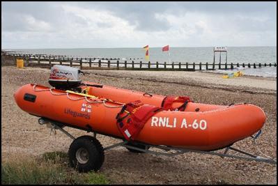
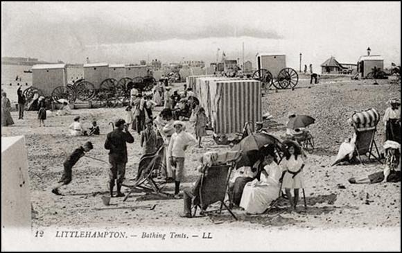
2 Key Terms River Arun Ghylls (small streams) Tarrant Tristantonis Estuary Arundel Littlehampton St Leonards Forest Learning Objectives To learn where the River Arun starts and ends To understand why the River Arun is important To understand why the River Arun has made Littlehampton important To establish a timeline and history of the River Arun 1
3 The River Arun The River Arun runs from St Leonard s Forest, on the east outskirts of Horsham, through down to Littlehampton where it meets the English Channel. It passes through many small villages before it reaches Littlehampton. The river begins in a series of small streams, known as ghylls, which feed the main river around the South Downs. The River Arun flows at a distance of approximately 25.5 miles, from source to mouth. It is famous for being the second fastest flowing river in England. History of the River Arun Legend suggests that the river existed in around 9 AD, with the stream being rumoured to have been narrow enough to be bridged by felling trees on both banks. The Arun was once named the Trisantonis with the name the Tarrant taken from it; it was given this name, translated to the trespasser due to its tendency to flood land near the river. The river was renamed after the town of Arundel by antiquarians. They took the del off the end due to its meaning of the valley of the river. Working backwards, they assumed that the town was named after the river, therefore the river must be given the same name as the town. The first use of the modern name was recorded in 1577, but the alternative names of Arundel River or Great River continued to be used for many years. The Arun did not always end at Littlehampton. Until the layer fifteenth century, the River Arun joined the River Adur at Lancing some ten miles to the east before entering the sea. This estuary later became blocked with shingle from the eastward drift of the tides. This pushed the Adur towards Shoreham-by-Sea, while the Arun broke out at Worthing, Goring and Ferring at various times, until the present estuary was formed at Littlehampton between 1500 and
4 Key Stage One and Two The River Arun is one of the main reasons for the existence of Littlehampton. It still plays a large part in the life of the town today. Although the use of the river nowadays is a lot different to the past, there are still reminders of the past and it is interesting to explore down its banks. The river is approximately 41km (or 25.5 miles) long. The River Arun is one of the fastest flowing rivers in England, up to 7 knots. It is rumoured to be the second fastest. The end of the river has not always been at Littlehampton. Until the end of the 1400s, the end of the river was at Lancing. It shared this spot at Lancing with the River Adur. When the end became blocked with shingle, the drift of the tides pushed the Adur towards Shoreham-by-Sea and the Arun toward Worthing. The current end of the river was formed between 1500 and Work on the river, by the Earl of Arundel, by the end of the 1500s made sure that Arundel became a major port. 3
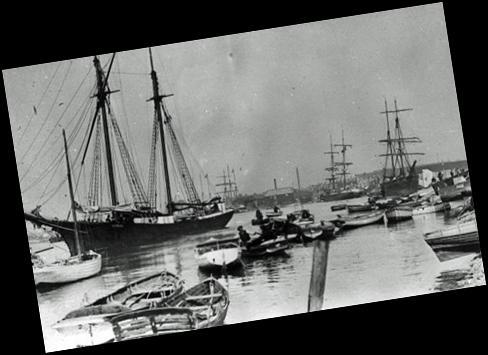
5 The River Arun has been used for centuries with evidence of ships on the river in Roman times. Over the years, work has been done on the harbour here at Littlehampton to improve it. In the 1500 s, the river was dredged, straightened and a pier built on either side of the river here at Littlehampton. In the 1820 s river access to Arundel for moneymaking boats became very difficult. This saw Littlehampton grow in importance. 4
6 Timeline of the River Arun 1139 The Empress Matilda sailed into England through Littlehampton Harbour to wage war against her cousin King Stephen The Earl of Arundel captured 120 ships, with a cargo of wine, at the harbour King Henry VIII s ships used the harbour as a supply base Improvements were made to the River Arun to aid navigation, including a new cut of the straight channel by the Commissioner of Sewers Sewer Commissioners made a further cut to the river. Sea defences were funded by the Duke of Norfolk Littlehampton starts to become an important trading port Horatio Nelson (later Lord Nelson) was in the port on 11 th September The piers were extended and the town developed crosschannel trade The Wey and Arun Canal was constructed to link London to English Channel through Littlehampton. 5

7 Map of the River Arun 6


8 Places along the River Arun Littlehampton Littlehampton still remains the primary port of Arun, and Littlehampton harbour commissioners are still responsible for the river up to Arundel. Arundel The town that the river is named after. The River Arun is first joined by the western River Rother before River Arun at Littlehampton making its way through Arundel. Originally, Arundel was one of the more prominent ports along the South Coast, due to the River Arun. However, with it becoming increasingly difficult for large trading boats to make their way along the river. However, with the coming of the railways, and changes in coastal shipping, Littlehampton River at Arundel passed Arundel as the port of Arun. The river flows past Arundel Castle and continues for another 7 miles before reaching the English Channel at Littlehampton. South Downs The River forces a path through the South Downs near Houghton. Amberley Ships used to trade with Amberley while using River through the South Downs the canal. Chalk and Lime were two of its main exports along the River Arun. Pulborough A cut, including three locks, was built here to avoid a large bend in the river. St Leonards Forest Part of the High Weald Area of Outstanding Natural Beauty, this is where the River Arun is Streams in St Leonards Forest 7 formed from the streams within the forest.
9 Teachers/Volunteers Notes The source of the River Arun is a series of small streams in the St Leonard's Forest area, to the east of Horsham. After flowing through Horsham to the west, it is joined by the North River at Nowhurst. Turning to the south, it is joined by its main tributary, the western River Rother, and continues through Arundel and past Arundel Castle, to join the English Channel at Littlehampton. The first major improvements to the river were made between the 1540s and the 1570s, when Arundel became a port, and navigation up to Pallingham was improved, but barges had difficulty negotiating the flash locks that were installed. The work was carried out by Henry FitzAlan, 19th Earl of Arundel, who made the upper section toll-free. Harbour commissioners managed the lower river from Arundel to the sea from 1732, and major improvements to keep the estuary free from silt were sanctioned by an Act of Parliament obtained in With the coming of the railways and changes in coastal shipping, Littlehampton superseded Arundel as the port of the Arun, and the Littlehampton harbour commissioners are still responsible for the river up to Arundel, collecting tolls for its use. The river above Arundel was improved after As the main channel was toll-free, the proprietors of the scheme built two major cuts. One, which included three locks and passed through Hardham Tunnel, was built to avoid a large bend near Pulborough. The other was near the upper terminus, where a cut with three locks crossed the original channel by an aqueduct to reach wharves at Newbridge. Further improvements were made when the Wey and Arun Canal opened in 1816, joining the Arun at Newbridge, and after the completion of the Portsmouth and Arundel Canal, which opened soon afterwards. These two canals were an attempt to provide an inland route between London and Portsmouth, but were not as 8
10 successful as the proprietors hoped. Traffic declined rapidly when the railways offered competition, and the navigation ceased to be maintained from 1888, though some traffic continued on the lower sections. The mouth of the river has not always been at Littlehampton. Until the later fifteenth century it joined the River Adur at Lancing some ten miles to the east before entering the sea. This estuary became blocked with shingle by the eastward drift of the tides, pushing the Adur towards Shoreham-by-Sea, while the Arun broke out at Worthing, Goring and Ferring at various times, until it formed its present estuary at Littlehampton between 1500 and


11 SEN We are flexible and open to the requirements of any child that visits the Look and Sea. We will therefore tailor the experience, in conjunction with teachers and carers, to the requirements and needs of each child. Guidelines for Teaching SEN Provide oral instructions and written instructions. Make instructions brief and clear, and teach one step at a time. When necessary, plan to repeat instructions in both written and oral forms. Give immediate feedback to students. Frequent progress checks and specific praise should be provided. Make activities concise and short; adjust work time so it matches attention span. Learning disabled students have difficulty learning abstract terms and concepts. Whenever possible, provide them with concrete objects and events items they can touch, hear, smell etc. Encourage cooperative learning activities when possible. Invite students of varying abilities to work together on a specific project or toward a common goal. Create an atmosphere in which a true community of learners is facilitated and enhanced. Students with physical impairments: Focus on the intellectual investment in an activity. That is, help the child use his or her problem-solving abilities and thinking skills in completing an assignment. 10
SHOREHAM BEACH LOCAL NATURE RESERVE
 SHOREHAM BEACH LOCAL NATURE RESERVE Coastal Geography Education Programme 2014-15 S. Savage 2014 COASTAL GEOGRAPHY OPPORTUNITIES Shoreham Beach Shoreham Beach is a shingle spit formed over many centuries
Unravelling Rivers. This pack consists of activity sheets for individual and group work, and whiteboard pictures for class discussion.
 Unravelling Rivers This pack consists of activity sheets for individual and group work, and whiteboard pictures for class discussion. Teacher guidance notes can be downloaded here. What do you know about
Case study 64. Shoreham Harbour Shingle Bypassing and Recycling
 Case study 64. Shoreham Harbour Shingle Bypassing and Recycling Authors: Tony Parker, Uwe Dornbusch Main driver: Improved defences Project stage: Ongoing construction/operation since 1992 Photo 1: Shoreham
There are toilets at Manningtree Station, Flatford (close to the hump back bridge) and in Dedham.
 and in Dedham.") Arriving by Train Main Features of the Walk Outline Route Employs particularly attractive paths, many of which offer impressive views across Dedham Vale. Includes a section along the tidal section of the
Arriving by Train Main Features of the Walk Outline Route Employs particularly attractive paths, many of which offer impressive views across Dedham Vale. Includes a section along the tidal section of the
SteerCert Objective. Detailed knowledge of Contents of key selected rules from ColRegs and PLA Byelaws Contents of Tideway Rowing Rules
 SteerCert Objective Detailed knowledge of Contents of key selected rules from ColRegs and PLA Byelaws Contents of Tideway Rowing Rules Knowledge of Right of way Signals Bridge passing guidelines Overtaking
Belgium Bruges for Kids Bike Tour (2018) Individual Self-guided 7 days / 6 nights
 Individual Self-guided 7 days / 6 nights") Belgium Bruges for Kids Bike Tour (2018) Individual Self-guided 7 days / 6 nights A truly surprising holiday! The region between the Belgian coast and the stunning city of Bruges is a very special one,
Belgium Bruges for Kids Bike Tour (2018) Individual Self-guided 7 days / 6 nights A truly surprising holiday! The region between the Belgian coast and the stunning city of Bruges is a very special one,
Maps The maps provided are a guide and are not to scale. Please use OS Explorer Map 120 (Chichester).
.") A Walker s Guide - Chichester Harbour Useful Information Directions All the walks were tested in 201. Please note, however, that some footpaths may be diverted and buildings such as pubs may have changed
A Walker s Guide - Chichester Harbour Useful Information Directions All the walks were tested in 201. Please note, however, that some footpaths may be diverted and buildings such as pubs may have changed
Lincolnshire Walks. Grainthorpe. Three circular walks of 2 ¾, 9 and 9 ½ km (1 ¾, 5 ½ and 6 miles)
") Lincolnshire Walks Grainthorpe Three circular walks of ¾, 9 and 9 ½ km (1 ¾, ½ and 6 miles) Introduction Explore the coastal marshes, arable hinterland, Louth Navigation canal and the village of Grainthorpe
Lincolnshire Walks Grainthorpe Three circular walks of ¾, 9 and 9 ½ km (1 ¾, ½ and 6 miles) Introduction Explore the coastal marshes, arable hinterland, Louth Navigation canal and the village of Grainthorpe
The History of Railways into Grimsby
 The History of Railways into Grimsby Grimsby at the beginning of the 19 th C was no more than a small east coast market town with a small dock, which suffered from silting problems. The population was
WELCOME TO THE MILLENNIUM RIBBLE LINK
 WELCOME TO THE MILLENNIUM RIBBLE LINK The prestigious 5.8m project to construct the Millennium Ribble Link opened in 2002. This is the first new navigation to be built in England since the Manchester Ship
River and Canal Maps
 River and Canal Maps for Trent Adventure Trent Adventure Base at Poplars Farm Twyford Road Twyford Barrow or Trent DE73 7HJ 07876 751 599 28-Apr-2015 2015 Trent Adventure - Version 3p4 1 Trent and Mersey
A27 Worthing and Lancing: facilities for walking, cycling, and horse riding [nonmotorised
 A27 Worthing and Lancing: facilities for walking, cycling, and horse riding [nonmotorised users (NMUs)] Introduction This note describes our understanding of the needs of Non-Motorised Users (NMUs) as
Vocabulary: Headwaters, watershed, tributaries, estuary, replica, point source pollution, nonpoint source pollution, amd river miles.
 From Source To Sea: Lesson Plan Concepts: 1. Understanding the path the Hudson River takes from the headwaters in the Adirondacks to the New York Harbor 2. Identifying the Hudson River watershed area,
Bike & Barge on the Moselle and Saar rivers from Koblenz to Merzig August 11 th 18 th 2018
 Saturday, DAY 1: Arrival in Koblenz Winningen Bike & Barge on the Moselle and Saar rivers from Koblenz to Merzig August 11 th 18 th 2018 The Merlijn, your sailing hotel already awaits you in the port of
Gayaza High School Geography Department
 THE DEVELOPMENT OF THE SAINT LAWRENCE SEAWAY This is an inland water way partly artificially constructed from the Gulf of St. Lawrence to the Western end of Lake Superior. It covers a distance of 3,800
Canals. All About. These notes are designed to help you with homework and other projects. canalriverexplorers.org.uk
 All About Canals These notes are designed to help you with homework and other projects. It will help you to discover: how canals are different from rivers why canals were built who built canals and when
Seashore Wildlife and Tides Education and Learning Pack
 Seashore Wildlife and Tides Education and Learning Pack 0 Key Terms Seashore Wildlife Tides East Beach West Beach Shingle Sand Dunes Marram Grass Site of Special Scientific Interest Maritime and Coastal
Walk 7: Watchet to washford
 Walk 7: Watchet to washford Length: Moderate - 7.5 miles / 12 km Good For: Theme: History Duration: 2-3 hours depending on speed of walking Notes: This is a moderate to difficult walk in places, with steps,
Visiting Lake Macquarie
 Visiting Lake Macquarie Lake Macquarie is the largest coastal salt water lake in Australia and is a prime boating destination for both small and large vessels. Many sailing regattas and fishing activities
Building Bridges. This pack consists of activity sheets for individual and group work, and whiteboard pictures for class discussion.
 Building Bridges This pack consists of activity sheets for individual and group work, and whiteboard pictures for class discussion. Teacher guidance notes can be downloaded here. Building Bridges: Build
France South Burgundy Bike Tour 2018 Individual Self-Guided 8 days / 7 nights
 France South Burgundy Bike Tour 2018 Individual Self-Guided 8 days / 7 nights Famous wines of Côte d Or and one of the most varied and finest cuisines of France are the first things you think of when hearing
Shepherdswell - Dover
 Shepherdswell - Dover The North Downs Way > Shepherdswell to Dover Introduction This part of the path is slightly different in character from most other parts of the path since it spends much of the time
Wexford Harbour. Yachting Guide. Navigation
 Wexford Harbour Yachting Guide Navigation This document supersedes all previous editions. Approvals: Yacht Club Committee April, 2015 Wexford Board of Directors April, 2015 # Date Section Revision 1 6.5.2015
Binder Page Name Per Exploring New York
 Binder Page Name Per Exploring New York Date This map shows the modern state of New York, and other surrounding states. 1. Put a dot on the map where Buffalo is located. Label it Buffalo. 2. Label the
This is to be considered the most interesting tour the Merlijn offers.
 RECENTLY RELEASED WEEK: JUNE 29 TH JUNE 6 TH 2019 Bike - and boat trip from Berlin/Spandau to Malchin This is to be considered the most interesting tour the Merlijn offers. You will hardly see other tourists,
The Kent Coast Coastal Access Report
 The Kent Coast Coastal Access Report This document is part of a larger document produced by Kent Area of the Ramblers Association and should not be read or interpreted except as part of that larger document.
Highland Region MAP. No. 11 St. Marys River No. 12 West River No. 13 Wallace River No. 14 Toney River No. 15 Northumberland Strait
 Highland Region MAP No. 11 St. Marys River No. 12 West River No. 13 Wallace River No. 14 Toney River No. 15 Northumberland Strait 14 Route: No. 11 St. Marys River Rating: Intermediate Advanced Length:
A Suggested Route Large Print
 National Maritime Museum Cornwall A Suggested Route Large Print This Large Print Guide was produced by the Heritage Ability team, part of Living Options Devon (charity number 1102489) www.heritageability.org
Baker Street Elementary. Presents The Life and Times in Victorian London
 Baker Street Elementary Presents The Life and Times in Victorian London Baker Street Elementary The Life and Times in Victorian London # 006 The Thames River 01 /29/201 7 Welcome to topic number 6 Today,
Geography of the Lower Fitzroy and navigation problems
 Geography of the Lower Fitzroy and navigation problems A topographic map of the Fitzroy estuary readily indicates why the Fitzroy River has proved difficult for shipping to negotiate. The river meanders
Saltash, Cornwall - Railways, Rivers & Castles
 Saltash, Cornwall - Railways, Rivers & Castles Starts at St Stephen's Church, Saltash, Cornwall 2 hours 45 minutes 5.5miles 8.9km Easy ID: 0.2532 Developed by: Peter Clements Checked by: Kevin Connor www.ramblersroutes.org
Lesson Resource Kit: Building the Rideau Canal
 Lesson Resource Kit: Building the Rideau Canal Grade 7: 1800 1850: Conflict and Challenges Lock, Blockhouse at the Narrows, Rideau Lake - the first descent from Summit towards Bytown, painted by Thomas
Port of London - River Thames NOTICE TO MARINERS U12 of 2017
 Port of London - River Thames NOTICE TO MARINERS U12 of 2017 MORTLAKE TO BARN ELMS REACH RIVER CLOSURES 2017/18 HEAD OF THE RIVER RACES The river will be closed to navigation between Mortlake and Putney
Chichester Harbour. A Walker s Guide
 A Walker s Guide - Chichester Harbour Chichester Harbour A Walker s Guide Chichester Harbour is an Area of Outstanding Natural Beauty on the south coast of Britain. Virtually flat with far reaching sea
Columbia River Navigation
 Columbia River Navigation HISTORY COMMITTEE Pat Brodin John Carpita Bob Moorhead Columbia River Navigation Columbia River Discovery & Exploration Columbia Bar Shipwrecks Graveyard of the Pacific Columbia
14 NOISE AND VIBRATION
 14 NOISE AND VIBRATION 14.1 EXISTING ENVIRONMENT 14.1.1 The noise environment within Poole Harbour is generally characterised by low to medium noise levels depending on location. For example, certain areas
Belgium - Majestic Cycling Along the North Sea Coast Bicycle Tour (2018) Individual Self-guided 7 days / 6 nights
 Individual Self-guided 7 days / 6 nights") Belgium - Majestic Cycling Along the North Sea Coast Bicycle Tour (2018) Individual Self-guided 7 days / 6 nights Culture, elegance and relaxation: these are the best words to describe this holiday. The
Belgium - Majestic Cycling Along the North Sea Coast Bicycle Tour (2018) Individual Self-guided 7 days / 6 nights Culture, elegance and relaxation: these are the best words to describe this holiday. The
Student Guide to a South Shore Boat Trip
 Student Guide to a South Shore Boat Trip Students use water sampling tools during their boat trip Outdoor and Environmental Education Program (516) 396-2264 www.nassauboces.org/outdoors Get Ready to Explore!
Okeechobee Waterway Speed Restrictions
 Okeechobee Waterway Speed Restrictions Rulemaking Authority 327.46 FS. Law Implemented 327.46 FS. History New 9-18-88, Amended 12-7-89, Formerly 16N-24.010, Amended 10-1- 96, Formerly 62N-24.010, Amended
PRESENTATION. On the following lines you ll find a detailed itinerary description of the 4 running days we ve prepared for you.
 PRESENTATION After many years of exploring Catalonian trails we ve came out with this bunch of great running routes, you ll get a taste of the very essence of this millenary land, their food, history and
Have homework out for me to check Need notes from yesterday Teaching Point: Understanding the terms of MAIN IDEA
 1. Unpack/ Use the Restroom 2. Sharpen 2 pencils 3. Write down homework 4. Show me your agenda 5. GET ALL READING MATERIALS 6. Work on Math Muscle 7. Work on i-ready when finished 8. Global Read Aloud
SAN DIEGO BAY PARADE OF LIGHTS 2017 SKIPPER'S INFO AND INSTRUCTIONS PLEASE READ ALL THE ENCLOSED INFORMATION AND FOLLOW INSTRUCTIONS.
 SAN DIEGO BAY PARADE OF LIGHTS 2017 SKIPPER'S INFO AND INSTRUCTIONS ***NOTICE THE CHANGE IN THE STARTING TIME*** PLEASE READ ALL THE ENCLOSED INFORMATION AND FOLLOW INSTRUCTIONS. QUESTIONS? Email: SDParadeOfLights@gmail.com
VESSEL HANDLING IN RIVERS AND ESTUARIES
 PROVIDING KNOWLEDGE AND KNOWHOW... ANYTIME, ANYWHERE VESSEL HANDLING IN RIVERS AND ESTUARIES Digital Edition Captain Robert L. Figular Page intentionally left blank VESSEL HANDLING IN RIVERS AND ESTUARIES
A circular walk of or km (2 1 4 or miles)
") Grantham A circular walk of 3 3 4 or 5 3 4 km (2 1 4 or 3 1 2 miles) Introduction This relatively short circular walk, which starts in the middle of Grantham, offers plenty of variety. The route takes
Grantham A circular walk of 3 3 4 or 5 3 4 km (2 1 4 or 3 1 2 miles) Introduction This relatively short circular walk, which starts in the middle of Grantham, offers plenty of variety. The route takes
Topic Check In b and 10.01c Units and measurement N
 Topic Check In - 10.01b and 10.01c Units and measurement 1. A three figure bearing of 090 is the same as which direction on a compass? W E 2. A compass bearing of SW is the same as which three-figure bearing?
Route Summary. Start and Finish Directions. Distance: 7 miles for an out and back trip to St Catherine s Lock Approximate Time: Time 3-5 Hours
 River Wey Guildford to St Catherine s Lock Moderate Trail: Please be aware that the grading of this trail was set according to normal water levels and conditions. Weather and water level/conditions can
Lecture 1 Why Do We Have Levees in Louisiana? J. David Rogers, Ph.D., P.E., R.G.
 Lecture 1 Why Do We Have Levees in Louisiana? J. David Rogers, Ph.D., P.E., R.G. Karl F. Hasselmann Chair in Geological Engineering Missouri University of Science & Technology for the First Annual Levee
Adapting and Developing Hands Free Mooring for Navigation Locks Speaker: Benoit Nolet
 Adapting and Developing Hands Free Mooring for Navigation Locks Speaker: Benoit Nolet The Great Lakes St. Lawrence Seaway System A gateway to the heartland of North America 3,700 km (2,300 m) marine highway
10 Miles Circular 5 hours
 VISIT RYEDALE PICKERING AND CAWTHORN CAMPS 10 Miles Circular 5 hours Moderate Terrain 120616 A 10 mile (16km) there and back walk from the market town of Pickering in Ryedale. The route heads north through
Pilotage. Planning for pilotage
 Pilotage Planning for pilotage Being one step ahead of the game is key to effective pilotage. Only then will you know what to expect and what s lurking around the next bend. It s useful to construct a
Great Lakes Shipping Across The Country & Around The World Great Lakes Floor Map: Shipping and Receiving Cargo on the Great Lakes
 Lesson #1 Lesson #2 Great Lakes Shipping Across The Country & Around The World Great Lakes Floor Map: Shipping and Receiving Cargo on the Great Lakes Laura Mikesell Laura.Mikesell@gpschools.org Parcells
Rules Practice Exam 5
 1 BOTH INTERNATIONAL & INLAND Vessel "A" (towing) and vessel "B" are meeting as shown. In this situation, which statement is TRUE? Diagram 12 A. Both vessels should alter course to starboard and pass port
The group discussed the draft proposal and agreed the following recommendations.
 NOTES e Title K&A review of Visitor Moorings (west) Date Wednesday 25 February 2015 Venue Attendees Canal & River Trust Office, Devizes Present, Nick Worthington, Matthew Symonds, Dale Marshall (Canal
Hydrographic Surveying Methods, Applications and Uses
 Definition: Hydrographic Surveying Methods, Applications and Uses It is the branch of surveying which deals with any body of still or running water such as a lake, harbor, stream or river. Hydrographic
Coast Survey Stretch 03 Seaview High Street to Sandown Zoo
 Coast Survey Stretch 03 Seaview High Street to Sandown Zoo Overview map of the stretch Introduction The route starts at the attractive village of Seaview, through the wooded Priory Bay, passing the remains
VISITING BOATS INFORMATION
 VISITING BOATS INFORMATION 2017 Seaham Harbour Marina is a joint venture between the Victoria Group and Durham County Council Marina Management Unit 10, The Waterside Seaham Harbour Marina, Seaham County
Wabbit Nationals August 5-7, 2018 Sport boat Invitational Multihull Invitational August 6-7, 2018
 Wabbit Nationals August 5-7, 2018 Sport boat Invitational Multihull Invitational August 6-7, 2018 SAILING INSTRUCTIONS Organizing Authority: Richmond Yacht Club, Point Richmond, California, USA 1 RULES
Hunters Hill to Epping Road
 Hunters Hill to Epping Road 2 hrs 30 mins 5.5 km One way Moderate track 154m An enjoyable walk through lower sections of the Lane Cove National Park, this walk features plenty of mangroves next to the
Eight Hour Coastal Tour
 Eight Hour Coastal Tour To start this coastal tour, you will be picked up at the Sea Terminal and driven north along Douglas Promenade, around Onchan Head and along the coast road to Groudle Glen. Groundle
National Maritime Center
 National Maritime Center Providing Credentials to Mariners (Sample Examination) Page 1 of 5 Choose the best answer to the following Multiple Choice Questions. 1. (The following questions are based on Chart
ROUND ABOUT NEW ZEALAND.
 ROUND ABOUT NEW ZEALAND. CHAPTER I. MELBOURNE TO DUNEDIN. EARLY in 1883 I left Melbourne for the " promised land" of New Zealand. From various reasons I had long made a point of acquiring all the information
The Oyster in Oyster Bay: Glaciers Set the Table
 The in Bay: Glaciers Set the Table In cooperation with NYS Department of Environmental Conservation Bay Long Island was created about 15,000 years ago when the last of the glaciers melted leaving behind
Sweden - Stockholm Round Trip Bicycle Tour 2019 Self-Guided Cycling Tour 7 days / 6 nights
 Sweden - Stockholm Round Trip Bicycle Tour 2019 Self-Guided Cycling Tour 7 days / 6 nights Discover Stockholm with its 14 islands and its surroundings along one of Sweden s largest lakes. Cycle through
On the timeline below, place these three important dates in William s life and write down what they stand for :
 This questionnaire is designed to sum up the basic and important facts about the castle. It is should be completed after the guided tour so that the students can recall what they just heard during their
Your web browser (Safari 7) is out of date. For more security, comfort and the best experience on this site: Update your browser Ignore
 is out of date. For more security, comfort and the best experience on this site: Update your browser Ignore") Your web browser (Safari 7) is out of date. For more security, comfort and the best experience on this site: Update your browser Ignore TIDAL BO RE For the complete encyclopedic entry with media resources,
Your web browser (Safari 7) is out of date. For more security, comfort and the best experience on this site: Update your browser Ignore TIDAL BO RE For the complete encyclopedic entry with media resources,
Community engagement guide May 2018
 Community engagement guide May 2018 Greater Wellington Regional Council (GWRC), Hutt City Council (HCC) and the New Zealand Transport Agency (NZTA) are working together to achieve some big improvements
Shoal Bay East Thurlow Island
 Shoal Bay East Thurlow Island Jason Zroback jason@landquest.com 1 (604) 414-5577 Jamie Zroback jamie@landquest.com 1 (604) 483-1605 The Source for Oceanfront, Lakefront, Islands, Ranches, Resorts & Land
Engineering Surveying - II CE313. Hydrographic Survey Lecture 06 Muhammad Noman
 Engineering Surveying - II CE313 Hydrographic Survey Lecture 06 Muhammad Noman Hydrographic Surveying Hydrographic surveying is the branch of the survey which deal with any body of still or running water
July 2017 to June 2018
 July 2017 June 2018 FREE walks led by trained volunteers www.adur-worthing.gov.uk/sport-and-leisure/ play-a-sport/walking Level 1 (30 minutes 1 hour) gentler walks. A very pleasant walk along the seafront
6 Miles Linear 3 hours
 6 Miles Linear 3 hours SUSSEX HOSPICES TRAIL PART 2: BARNHAM TO ARUNDEL Moderate Terrain 131016 A 6 mile linear walk from Barnham rail station to Arundel rail station in West Sussex, forming the second
Chapel Point to Anderby Creek
 Coastal Country Park Walks Chapel Point to Anderby Creek A CIRCULAR WALK OF 8.5 OR 6 KM (5.3 OR 3.75 MILES) INTRODUCTION The Lincolnshire Coastal Country Park lies between Sandilands, Chapel St Leonards
The Port of Virginia and Economic Development
 The Port of Virginia and Economic Development RODNEY W. OLIVER, CHIEF FINANCIAL OFFICER VIRGINIA PORT AUTHORITY 1 EAST COAST / WEST TRADE BALANCE 2 AN IMPORT PARADIGM SHIFT The West Coast has traditionally
Nearest Town: Guildford Start and Finish: Riverside Road, Bellfields, Guildford GU1 1LN. Local Facilities: In Guildford
 River Wey and Godalming Navigations- Guildford to Shalford Easy to Moderate Trail: Please be aware that the grading of this trail was set according to normal water levels and conditions. Weather and water
NavRule Practice Exam, 70 Series Practice April 24, Labeled F (I received a reply from the testing service that all these answers were
 1. INTERNATIONAL & INLAND An all-round flashing yellow light may be exhibited by a(n)? a. vessel laying cable b. vessel towing a submerged object c. vessel not under command d. air cushion vessel 2. INTERNATIONAL
Port Information & Tide Timetable
 Port Information & 01 Tide Timetable Welcome to Littlehampton! A WARM welcome to Littlehampton Harbour. I hope this guide will help you to get the best out of your time here. Littlehampton is a small but
I Am Going For A Walk Around the Washington, D.C. Tidal Basin!
 Ability Guidebooks presents Explore Washington, D.C.! I Am Going For A Walk Around the Washington, D.C. Tidal Basin! A Step-by-Step Guide On How To Tour This National Attraction by Brett Bigham WWW.MrBsClassroom.com
IDENTIFYING SKILL GAPS IN THE KNOWLEDGE AND TEACHING OF COLREGS
 IDENTIFYING SKILL GAPS IN THE KNOWLEDGE AND TEACHING OF COLREGS ABSTRACT Đani Mohović, Ph.D. Robert Mohović, Ph.D. Mate Barić, B.Sc. University of Rijeka Faculty of Maritime Studie Studentska 2, 51000
FAST CRAFT IN THE BLACKWATER ESTUARY
 FAST CRAFT IN THE BLACKWATER ESTUARY Thank you for taking the time to read this booklet. It has been put together to help you understand a little of the geography of the area, why the byelaws exist, the
SELF GUIDED TOURING ROUTE
 SELF GUIDED TOURING ROUTE Things to see and places to go on the loop from Orbost to Marlo, Cape Conran, Cabbage Tree and back to Orbost (or onwards to Cann River) V6 April 2017 This guide should be read
Code Of Practice For Towage Operations In The Port of St Helier (Towage Guidelines)
") Code Of Practice For Towage Operations In The Port of St Helier (Towage Guidelines) This Code Covers The Use Of Tugs And Towage In The Port Of St Helier Page number Contents 2 Introduction 3 Communication
Code Of Practice For Towage Operations In The Port of St Helier (Towage Guidelines) This Code Covers The Use Of Tugs And Towage In The Port Of St Helier Page number Contents 2 Introduction 3 Communication
Ocean Currents Unit (4 pts)
") Name: Section: Ocean Currents Unit (Topic 9A-1) page 1 Ocean Currents Unit (4 pts) Ocean Currents An ocean current is like a river in the ocean: water is flowing traveling from place to place. Historically,
Name: Section: Ocean Currents Unit (Topic 9A-1) page 1 Ocean Currents Unit (4 pts) Ocean Currents An ocean current is like a river in the ocean: water is flowing traveling from place to place. Historically,
explore AerodYnAmics Texas Alliance for Minorities in Engineering, Trailblazer II
 explore AerodYnAmics EXPLORE AERODYNAMICS YOUR MISSION: Help students understand why aerodynamics are important. Encourage them to imagine themselves with a job in this field, designing cars, buildings,
SS&S Chapter 8 Instructor Guide
 SS&S Chapter 8 Instructor Guide The Rules of the Nautical Road The PowerPoints (PPT) slides for this SS&S chapter were copied from the BS&S-13 th Ed PPT because they are identical. Only the chapter numbers
National Maritime Center
 National Maritime Center Providing Credentials to Mariners Q301 Rules of the Road-Inland (Sample Examination) Page 1 of 19 Choose the best answer to the following Multiple Choice Questions. NO reference
AID VERIFIER QUIZ. 1. How often is the Light List published? a. One a year b. Twice a year c. Every Month d. Quarterly
 Qualification as an Aid Verifier in the Auxiliary presumes a knowledge of navigational aids above that of the ordinary member. Questions on the subject may be directed to the AV as he/she is considered
July 2018 to June 2019
 July 2018 to June 2019 FREE walks led by trained volunteers www.adur-worthing.gov.uk/sport-and-leisure/ play-a-sport/walking Note: The routes of many walks may vary due to ongoing river defence work. Level
Mentoring in the USCG Auxiliary Boat Crew Program Coxswain Mentoring Template
 Notes: 1. When there is no reading assignment specified, the entire chapter contains references to the topic. 2. The study questions in the Qualification Guide should be completed for each task. Boat Crew
SAILING CLUB SPLIT, CROATIA IS BIDDING FOR Finn Masters Euro Cup
 SAILING CLUB SPLIT, CROATIA IS BIDDING FOR 2017 Finn Masters Euro Cup 1 Introduction CROATIA SPLIT SPLIT The second-largest city in Croatia, Split is a great place to see Dalmatian life as it's really
Cook Inlet pipeline crossing is about making the best choices
 Cook Inlet pipeline crossing is about making the best choices By Larry Persily lpersily@kpb.us Aug. 26, 2015 (This update, provided by the Kenai Peninsula Borough mayor s office, is part of an ongoing
A Nautical View of Vermont. Christy Leonard LS07055
 A Nautical View of Vermont Christy Leonard LS07055 The importance of boating in the Champlain Valley grew during French and British military conflicts over waterways. Vermont waterways were important because
The Griffon Guide The North Walsham and Dilham Canal Trail
 The Griffon Guide The North Walsham and Dilham Canal Trail This trail explores some of the most accessible and interesting parts of the North Walsham and Dilham Canal. The canal was built in 1825 to allow
Thames Passage From Brentford to Teddington
 Thames Passage From Brentford to Teddington Introduction: The Thames Ring route uses a tidal section of the river Thames between Brentford and Teddington that requires extra preparation and skill. We hope
RAILWAY SAFETY. Please click on any of the links below to go directly to your specified topic within this document.
 RAILWAY SAFETY Please click on any of the links below to go directly to your specified topic within this document. Facts about Railway Property and Trains Railway Signs, Devices, and Warnings Railway Safety
Fastest in the Forest Regatta Sunday, October 2, 2016 EFYCC Marina. Notice of Race
 Fastest in the Forest Regatta Sunday, October 2, 2016 EFYCC Marina Epping Forest Yacht and Country Club 1830 Epping Forest Drive Jacksonville, Fl. 32217 Notice of Race 1.0 RULES The Regatta will be governed
WINDING HOLES towards a specification for the ideal turning place
 WINDING HOLES towards a specification for the ideal turning place Introduction The term winding hole is normal in the narrow canal network, and on adjoining broad canals, for a space in which to turn a
THE REPUBLIC OF LIBERIA LIBERIA MARITIME AUTHORITY
 THE REPUBLIC OF LIBERIA LIBERIA MARITIME AUTHORITY 8619 Westwood Center Drive Suite 300 Vienna, Virginia 22182, USA Tel: +1 703 790 3434 Fax: +1 703 790 5655 Email: safety@liscr.com Web: www.liscr.com
1. Kala Nera Milies Kala Nera
 1. Kala Nera Milies Kala Nera A beautiful and varied walk from Kala Nera, a tourist seaside village, to Milies which lies 400 metres higher up. From there it proceeds back down to Kala Nera along another
SCATE. South Coast Alliance on Transport and the Environment. Issues to be addressed by the A27 Corridor Feasibility Study
 SCATE South Coast Alliance on Transport and the Environment Issues to be addressed by the A27 Corridor Feasibility Study Submitted to the Department of Transport July 2014 Contents: 1. The evidence so
Studland Bay Context and Learning Aims
 Studland Bay Enquiry 7: How are coastal processes affecting Studland Bay? Context and Learning Aims Pupils will be supported in and outside of the classroom to: Identify; describe and explain the physical
Montessori for Everyone 2013 Types of Coastlines
 Coast The coast is the part of the land that borders the sea. It is subject to constant change, as the result of the waves and deposits carried by water onto the land. Coastline The coastline is where