ST. LOUIS SECTION PROJECT OF THE YEAR AWARD
|
|
|
- Godfrey Bradley
- 5 years ago
- Views:
Transcription
1 ST. LOUIS SECTION PROJECT OF THE YEAR AWARD
2
3
4
5
6
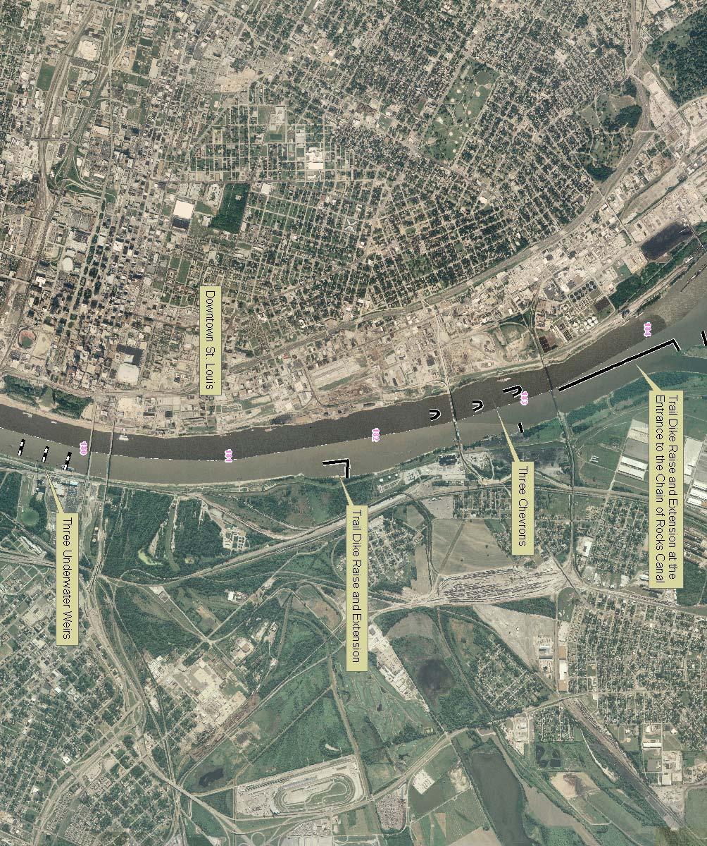
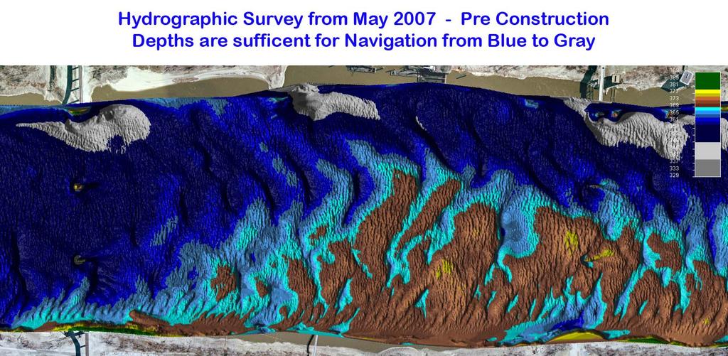
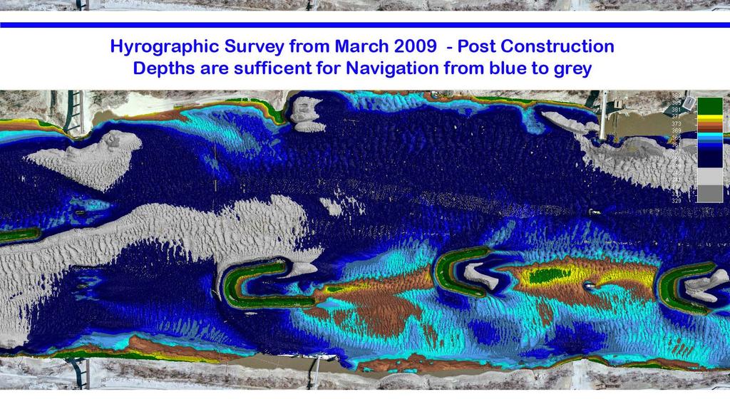
7 Originality and Innovation The St. Louis Harbor Project is located in the Upper Mississippi River between the entrance to the Chain of Rocks Canal at River Mile through the Downtown St. Louis area at River Mile This project was designed to alleviate a repetitive dredging problem, improve dangerous navigation conditions through several bridge crossings and assist local facilities with shoaling problems all in an environmentally sensitive manner. Sedimentation and navigation channel alignment are the primary challenges to maintaining the inland waterways system. The Army Corps of Engineers, as part of its mandate from Congress, must maintain a dependable navigation channel on these waterways, and thus, must confront sedimentation and alignment problems where they exist. In the past, these problems were largely solved by installing spur dikes perpendicular to the bank line to constrict the channel. However, these dikes as well as the resulting sedimentation surrounding them impeded access to the bankline and can create a river environment void of habitat diversity. The project consisted of constructing three Chevrons through a shoaling area, raising and extending an existing Trail Dike at the entrance to the Chain of Rocks Canal, raising and extending another existing Dike and Trail and building three underwater weirs. These river training structures are constructed with 5000 lb top size limestone which is quarried along the Mississippi River and is natural and widely available. All construction materials and equipment is transported efficiently by river barge and all river training structures are constructed from the river, not from the bankline. Once placed, these structures are expected to have a life cycle of at least fifty years with minor repairs expected only after extreme flood or ice events. The chevrons, dikes and weirs have no ongoing energy demands once they are constructed. These structures are sustainable in both the material used, the energy demands to build them, and the minimal amount of O&M required. In fact, these structures will save a tremendous amount of energy by utilizing the natural power of the river to shape and maintain the navigation channel rather than repeatedly using a man-made dredge to shape the river.
8 Due to the success of chevrons in the St. Louis District, other Districts within the Mississippi Valley Division, with guidance from the St. Louis District, have started using these structures to create and promote split flow areas. In the past, chevrons were primarily used to deflect flows from natural side channel entrances to create small side channels through sedimentation areas or as a location to deposit dredge spoil. This project was the first of its kind in that it used chevrons to split the main navigation channel into two separate self sustaining navigable channels. By splitting the flow, deposition problems were alleviated in the main channel and along the bankline where facilities fleet. Resourcefulness in Planning and Solving Design Challenges As the third busiest port in the inland waterways system, it was important to create a dependable and efficient navigation channel that would not continue to cost the U.S Taxpayer through ongoing dredging requirements and inefficient transportation of commodities. The project has been very successful in achieving its goals of improving the navigation channel by alleviating repetitive dredging areas, aligning the navigation channel under multiple bridge spans and assisting local facilities with shoaling problems all in an environmentally sensitive manner. The trail dike extension at the entrance to the Chain of Rocks Canal eliminated a dredging problem, concentrating flows toward the shoaling area and alleviated a cross current that made lining up for the bridge span treacherous. The chevrons created a split flow that resulted in two navigable channels, while also creating a diverse habitat area. Raising and extending the second trail dike helped align the navigation channel thalweg through additional bridge spans and deepened a channel crossing that often required dredging for depth. Lastly, the weirs assisted with an additional dredging area directly across from downtown St. Louis and further aligned the navigation channel through another set of bridge spans. The size and scope of this project required the partnering of many disciplines within the Corps of Engineers to work from design through construction. This included Hydraulic Engineers, Surveyors, Fisheries Biologists, Dredging Managers, Project Analyst, Contract Specialists, and Construction Managers. Throughout the construction process the Hydraulic Design Engineers, Surveyors and
9 Construction Managers worked closely with the contractor, Patton Tully to insure the quality construction of these highly visible structures. Sustainability Considerations Environmental Sustainability The structures in the St. Louis Harbor have also created a more sustainable aquatic environment. These chevrons in particular have provided a more diverse habitat then what was available in the St. Louis Harbor prior to their construction. The fish community before the construction of the chevrons in the St. Louis Harbor was typical of most open river habitat - very low catch rates with few species retrieved during samplings. Before construction, the harbor consisted of the usual main channel and channel border habitats along with stretches of quality, shallow water habitat along the right descending bank. In an effort to retain the shallow water habitat while enhancing the remaining habitat, the chevrons were designed to create a split-flow within the harbor. Within the chevron field, there were many different habitat types created. The first habitat type is a deep scour hole enclosed by each chevron. As water overtops the chevron, it travels down towards the riverbed and scours a large, deep plunge pool. The large, deep plunge pools created by the chevrons provides protected overwintering habitat for several species. In addition to the deep plunge pools, a second habitat type forms when the surface water enclosed by the chevron has become pond-like (lower flow velocities) and supports many backwater fish species such as Largemouth Bass and Bluegill. The third type of habitat developed is a sand bar island. The sediment that is scoured during the formation of the deep plunge pools deposits immediately downstream of the chevrons, forming visible sand bar islands. These islands increase the acreage of shallow water habitat and habitat diversity in the St. Louis Harbor. The number of species retrieved post-construction is more than double that of pre-construction thus indicating the harbor is more diverse after chevron dike construction. Overall, an increase in the number of species collected and habitat diversity has been noted around the chevrons in the St. Louis Harbor of the Middle Mississippi River.
10 There are also positive environmental effects from the trail dikes constructed as part of this project. Like the chevrons mentioned above, the trail dikes create a backwater type habitat that is separated but accessible from the main flow of the channel. Social Sustainability The primary customers for this project are the Navigation Industry and the facilities that use the St. Louis Harbor as well as the U.S. Taxpayer. As the primary customers, the Navigation Industry was actively involved in the design of this project, which utilized a Hydraulic Sediment Response (HSR) Model. The HSR Model showed that a design could be achieved that would help reduce or alleviate the dredging problems while at the same time creating a split flow channel that allowed local businesses access to their riverbank facilities. The project has also streamlined the navigation channel thalweg through the appropriate navigable bridge spans and will reduce the risk of accidents associated with these bridge crossings. Lange-Stegmann, a company located along the Missouri side of the Mississippi River and adjacent to the Chevrons had this to say: All of us at Lange-Stegmann Co. could not be more pleased with the results! We have experienced exactly zero (0) down days as a result of low water in the STL Harbor compared to hundreds of thousands of dollars prior to this project. In fact, our major expansion project hinged on the success of this project, and it has performed tremendously!" - Rich Coffman Lange-Stegmann Co. Economic Sustainability The St. Louis District has been tasked with providing a safe and dependable navigation channel within the Mississippi River between Upper Mississippi River Miles 300 to 0. Dredging is often used as a temporary solution to maintaining the navigation channel for either width or depth. However since this is only a temporary solution, river training structures are used as a permanent way to eliminate or reduce
11 dredging needs in the navigation channel. Dredging requirements within the St. Louis Harbor have resulted in a cost of $4.4 million to dredge 2.91 million cubic yards of material over the last 10 years. This averages to $440,000 spent each year for dredging. Construction cost for the St. Louis Harbor Project is $5.63 million, with environmental monitoring costing $120,000. Considering the average annual dredging requirements, the project is expected to pay for itself within 13 years. Additional cost savings should be observed in the project area due to the expected reduction in accidents with a more reliable and aligned navigation channel. Between the years 1997 and 2007 there have been 41 accidents in the Upper Mississippi River between Miles and Accidents are defined as collisions (between two vessels), allisions (between a vessel and a stationary object) or groundings (between vessel and the channel bottom). Total costs of the accidents can vary depending on the severity and type of accident, however accidents in the St. Louis Harbor can have an impact to more than just the vessel involved since a channel shut down impacts any vessel trying to pass. Project Planning and Delivery The St. Louis Harbor Project was funded through the Corps of Engineers Regulating Works Project and additional Congressional Funding and was constructed within budget. The clients for this project are the navigation industry, local fleeting operators, the environmental community, and the U.S. Taxpayer. The project is working as expected and industry appears to be satisfied with the reduction in dredging in the harbor. Contribution to the Well-being of People and Communications, Including Aesthetic Value The St. Louis Harbor Project has alleviated dredging problems and has created a split flow channel that allows local businesses access to their riverbank facilities. The project has also streamlined the
12 navigation channel thalweg through the appropriate navigable bridge spans and reduced the risk of accidents associated with these bridge crossings. The design is also environmentally sensitive by creating habitat within the chevron and trail dike structures. During normal flow conditions, a chevron provides many different habitat benefits including a deep plunge pool in calm waters directly within the structure boundaries, fast and slow flow areas around the edges of the structure as well as shallow water and sandbar habitat in the downstream shadow of the structure. Since the construction of the Chevrons in the St. Louis Harbor, fisheries diversity has more than doubled and includes many desirable species that were not present before construction. Many recreational fishermen have discovered the calm waters behind these structures where fish thrive in an area of the river that historically had a habitat that was less diverse. Reducing the dredging in this reach of the river has a cost savings to the taxpayer in both the cost of dredging and the elimination of the disruption dredging causes to the navigation industry. These cost saving are passed on to consumers using the products that are transported on the Mississippi River. The dredging savings in the St. Louis Harbor are projected to pay for the project in approximately 13 years. The application and shape of river training structures is dictated by their intended purpose where form is defined by function. Because of this, traditional river training structures often appear in opposition to their surrounding environment, the neat stone lines of a dike can conflict with the sinuosity of the river or the unrestrained growth of natural habitat. One of the main benefits of the use of more innovative structures like chevrons is that they promote the growth of natural habitat by means of sandbar or island creation, which brings river training structures in tune with not just the dynamics of the river, but also the environmental and aesthetic aspects of their surroundings. As a local benefit, with their proximity to downtown St. Louis and its famous landmark the Arch, the chevrons in the St. Louis Harbor invoke comparisons in the waterway to what has been built as part of the skyline. During the construction of the Chevrons, local news media often referred to the Chevrons as the Arches in the river.
13


14
15
Estimated on-the-ground start and end dates: 1 June October 2018
 A. Applicant Information Name of Organization: U.S. Army Corps of Engineers, Carlyle Lake 801 Lake Road, Carlyle, IL 62231 Contact Information: Robert Wilkins, Operations Manager, (618) 594-2484, Robert.Wilkins@usace.army.mil
VIDEO AUDIO Slide 1. Slide 2 Old timey 18 th century map of east coast
 VIDEO AUDIO Slide 1 1A Welcome to the Cooper River Rediversion Project at St. Stephen, Montage of exteriors of facility, South Carolina! Since 1985, this boating, fish runs, fishing, facility has served
30 DAY PUBLIC NOTICE MAINTENANCE DREDGING OF THE 8-FOOT CHANNEL OF THE FEDERAL NAVIGATION PROJECT IN KENNEBUNK RIVER KENNEBUNK & KENNEBUNKPORT, ME
 fr.iiif.i ~ US Anny Corps of Engineers New England District 696 Virginia Road Concord, MA 01742-2751 Public Notice In Reply Refer to: Mr. Jack Karalius nae-pn-nav@usace.army.mil Programs/Project Management
SEDIMENTATION AND NAVIGATION STUDY OF THE LOWER MISSISSIPPI RIVER AT THE WHITE RIVER CONFLUENCE, MILES 603 TO 596 HYDRAULIC MICRO MODEL INVESTIGATION
 Technical Report M7 SEDIMENTATION AND NAVIGATION STUDY OF THE LOWER MISSISSIPPI RIVER AT THE WHITE RIVER CONFLUENCE, MILES 603 TO 596 HYDRAULIC MICRO MODEL INVESTIGATION By David C. Gordon Robert D. Davinroy
FACT SHEET I. LOCATION
 STEAMBOAT ISLAND HABITAT REHABILITATION AND ENHANCEMENT PROJECT (HREP) SCOTT COUNTY, IOWA, UPPER MISSISSIPPI RIVER RESTORATION-ENVIRONMENTAL MANAGEMENT PROGRAM ROCK ISLAND DISTRICT FACT SHEET I. LOCATION
FACT SHEET MCGREGOR LAKE RESTORATION HABITAT PROJECT POOL 10, UPPER MISSISSIPPI RIVER, WISCONSIN ENVIRONMENTAL MANAGEMENT PROGRAM
 FACT SHEET MCGREGOR LAKE RESTORATION HABITAT PROJECT POOL 10, UPPER MISSISSIPPI RIVER, WISCONSIN ENVIRONMENTAL MANAGEMENT PROGRAM LOCATION McGregor Lake is located within a mid-river island in Pool 10
Information for File # SEW
 Information for File #2014-02744-SEW Applicant: Minnesota Department of Transportation (MnDOT), District 3; c/o Mr. Robert Nibbe Corps Contact: Sarah Wingert, U.S. Army Corps of Engineers, 180 5 th Street
Ketchikan Harbors Thomas Basin and Bar Point Harbor
 Ketchikan Harbors Thomas Basin and Bar Point Harbor Condition of Improvements 30 December 2014 Thomas Basin & Bar Point Harbors Ketchikan, Alaska (CWIS No. 000631 & 087071) Authorization (1) Rivers and
Water Resources Report RKLD Annual Meeting July 30, 2016
 Water Resources Report RKLD Annual Meeting 2016 July 30, 2016 Topics Hydrology Report Indianford Dam trash rack cleanout performance Experimental Project update Review of PAS project Twin floods- 1 to
The proper location of the mouth of the Salinas River is a very difficult problem. - U.S. Surveyor General for California (1879)
") The proper location of the mouth of the Salinas River is a very difficult problem - U.S. Surveyor General for California (1879) 1854 1854 early 1830s early 1830s early 1830s late 1830s late 1830s early
The proper location of the mouth of the Salinas River is a very difficult problem - U.S. Surveyor General for California (1879) 1854 1854 early 1830s early 1830s early 1830s late 1830s late 1830s early
Coastal Harbors and Waterways, NC (Shallow Draft Navigation) (O&M)
 (O&M)") Coastal Harbors and Waterways, NC (Shallow Draft Navigation) (O&M) Shallow draft coastal harbors include a subsistence harbor at Silver Lake CONGRESSIONAL DISTRICT: NC 3 and 7 DATE: 23 February 2015 1.
Coastal Harbors and Waterways, NC (Shallow Draft Navigation) (O&M) Shallow draft coastal harbors include a subsistence harbor at Silver Lake CONGRESSIONAL DISTRICT: NC 3 and 7 DATE: 23 February 2015 1.
MOREHEAD CITY HARBOR, NC. Dredged Material Management Plan (DMMP)
") MOREHEAD CITY HARBOR, NC Dredged Material Management Plan (DMMP) Public Meeting/Info Session 15 January 2014 US Army Corps of Engineers Morehead City Harbor DMMP Presentation Topics Morehead City Harbor
MOREHEAD CITY HARBOR, NC Dredged Material Management Plan (DMMP) Public Meeting/Info Session 15 January 2014 US Army Corps of Engineers Morehead City Harbor DMMP Presentation Topics Morehead City Harbor
Emergent Sandbar Habitat Program Middle Missouri River
 Emergent Sandbar Habitat Program Middle Missouri River Jeremiah Szynskie, P.E. Hydrologic Engineering Branch Introduction Main Stem System Dam Closures Fort Peck 1937 Fort Randall 1952 Garrison - 1953
1-32 NOME HARBOR, ALASKA (CWIS NOS , 87755, 12270, & 10422) Condition of Improvement 30 September 2012
 Condition of Improvement 30 September 2012") NOME HARBOR 1-32 NOME HARBOR, ALASKA (CWIS NOS. 72742, 87755, 12270, & 10422) Condition of Improvement 30 September 2012 AUTHORIZATION: (1) Rivers and Harbors Act, 8 August 1917 (House Doc. 1932, 64th
NOME HARBOR 1-32 NOME HARBOR, ALASKA (CWIS NOS. 72742, 87755, 12270, & 10422) Condition of Improvement 30 September 2012 AUTHORIZATION: (1) Rivers and Harbors Act, 8 August 1917 (House Doc. 1932, 64th
Nome Harbor Page 2 of 12
 Nome Harbor Nome Harbor Page 2 of 12 Condition of Improvements 30 December 2015 Nome Harbor, Alaska (CWIS No. 010422, 012270, 072742, 087755) Authorization (1) Rivers and Harbors Act, 8 August 1917 (House
Innovative Technologies for a Resilient Marine Transportation System
 Innovative Technologies for a Resilient Marine Transportation System Transportation Research Board MG John Peabody, P.E. Deputy Commanding General for Civil and Emergency Operations, U.S. Army Corps of
EcoLogic Memorandum. TO: Ben Brezell; EDR FROM: Mark Arrigo RE: Possible Impacts of Dredging Snooks Pond DATE: 6/4/07
 EcoLogic Memorandum TO: Ben Brezell; EDR FROM: Mark Arrigo RE: Possible Impacts of Dredging Snooks Pond DATE: 6/4/07 Background EDR P.C. (EDR) has been contracted by a landowner to assess the feasibility
Dredging Keeping Our Underwater Highways Open
 Dredging Keeping Our Underwater Highways Open Sedimentation Material that falls to the bottom of a liquid is called sediment. If enough sediment deposits to build a shallow spot on the river or ocean bottom,
natural low-water ' conditionson tamed Mississippi, new life springs, up Vl ' V ' ' - "
 When an experiment mimics natural low-water ' conditionson tjhe tamed Mississippi, new life springs, up in the \ backwaters. Vl ' V ' ' - " y *.»* ' ' ' - ' ' by JASON ABRAHAM Common map turtle Mississippi
Applying Engineering Solutions to the Science of Protection and Enhancement of Aquatic Environments. Bill Holman, P.E. Stanley Consultants
 Applying Engineering Solutions to the Science of Protection and Enhancement of Aquatic Environments Bill Holman, P.E. Stanley Consultants Project Development PHASE STAGE TASKS PURPOSE I II III Investigation
JAP Additional Information Sheet
 JAP Additional Information Sheet Block 15: Purpose and Need The USACE purpose of the project is to provide a safe and reliable whitewater park for the recreational public in a city park, which will provide
Coastal Harbors and Waterways, NC (Shallow Draft Navigation) (O&M)
 (O&M)") Coastal Harbors and Waterways, NC (Shallow Draft Navigation) (O&M) Shallow draft coastal harbors include a subsistence harbor at Silver Lake CONGRESSIONAL DISTRICT: NC 3 and 7 DATE: 23 February 2015 1.
Coastal Harbors and Waterways, NC (Shallow Draft Navigation) (O&M) Shallow draft coastal harbors include a subsistence harbor at Silver Lake CONGRESSIONAL DISTRICT: NC 3 and 7 DATE: 23 February 2015 1.
U.S. Army Corps of Engineers (USACE) P.O. Box 428 Smithville, MO
 P.O. Box 428 Smithville, MO") Applicant Information United States Army Corps of Engineers Kansas City District Principal Contact: Derek Dorsey, Natural Resource Manager U.S. Army Corps of Engineers P.O. Box 428 Smithville, MO 64089
Applicant Information United States Army Corps of Engineers Kansas City District Principal Contact: Derek Dorsey, Natural Resource Manager U.S. Army Corps of Engineers P.O. Box 428 Smithville, MO 64089
CORPS FACTS. Harbor Dredging U.S. ARMY CORPS OF ENGINEERS BUILDING STRONG
 CORPS FACTS Harbor Dredging U.S. ARMY CORPS OF ENGINEERS BUILDING STRONG Disaster Response Sedimentation in the channel is caused by the normal cycle of silt movement, erosion from high water or heavy
Coastal Harbors and Waterways, NC (Shallow Draft Navigation) (O&M)
 (O&M)") Coastal Harbors and Waterways, NC (Shallow Draft Navigation) (O&M) Shallow draft coastal harbors include a subsistence harbor at Silver Lake CONGRESSIONAL DISTRICT: NC 3, 7 DATE: 23 April 2018 1. AUTHORIZATION:
Coastal Harbors and Waterways, NC (Shallow Draft Navigation) (O&M) Shallow draft coastal harbors include a subsistence harbor at Silver Lake CONGRESSIONAL DISTRICT: NC 3, 7 DATE: 23 April 2018 1. AUTHORIZATION:
Building Coastal Resiliency at Plymouth Long Beach
 Building Coastal Resiliency at Plymouth Long Beach Department of Marine and Environmental Affairs March 30, 2017 Introducing Green Infrastructure for Coastal Resiliency Plymouth Long Beach & Warren s Cove
PNWA Conference Update
 PNWA Conference Update COLONEL Jose Aguilar District Commander Portland District 2 October, 2014 US Army Corps of Engineers Projects Mouth of the Columbia (MCR) Jetties Columbia River Status Coastal Dredging
FISH PASSAGE ALTERNATIVES ANALYSIS ON PENNYPACK CREEK AT VERREE ROAD DAM AND ROOSEVELT BOULEVARD DAM PHILADELPHIA, PENNSYLVANIA
 FISH PASSAGE ALTERNATIVES ANALYSIS ON PENNYPACK CREEK AT VERREE ROAD DAM AND ROOSEVELT BOULEVARD DAM PHILADELPHIA, PENNSYLVANIA Prepared for: One Parkway, 10 th Floor 1515 Arch Street Philadelphia, PA
Washington State Fish Passage Barrier Removal Projects. Casey Kramer, PE WSDOT State Hydraulics Engineer
 Washington State Fish Passage Barrier Removal Projects Casey Kramer, PE WSDOT State Hydraulics Engineer 2014 National Hydraulic Engineering Conference Iowa City, IA August 20 th, 2014 WSDOT Fish Passage
1-32 NOME HARBOR, ALASKA (CWIS NOS , 87755, & 10422) Condition of Improvement 30 September 2009
 Condition of Improvement 30 September 2009") NOME HARBOR 1-32 NOME HARBOR, ALASKA (CWIS NOS. 72742, 87755, & 10422) Condition of Improvement 30 September 2009 AUTHORIZATION: (1) Rivers and Harbors Act, 8 August 1917 (House Doc. 1932, 64th Congress,
NOME HARBOR 1-32 NOME HARBOR, ALASKA (CWIS NOS. 72742, 87755, & 10422) Condition of Improvement 30 September 2009 AUTHORIZATION: (1) Rivers and Harbors Act, 8 August 1917 (House Doc. 1932, 64th Congress,
Illinois Lake Management Association Conference March 23, 2018 By Trent Thomas Illinois Department of Natural Resources Division of Fisheries
 Illinois Lake Management Association Conference March 23, 2018 By Trent Thomas Illinois Department of Natural Resources Division of Fisheries Sources of Habitat Impairment Sedimentation Channelization
NEVADA DEPARTMENT OF WILDLIFE STATEWIDE FISHERIES MANAGEMENT
 NEVADA DEPARTMENT OF WILDLIFE STATEWIDE FISHERIES MANAGEMENT FEDERAL AID JOB PROGRESS REPORTS F-20-50 2014 BILK CREEK RESERVOIR WESTERN REGION 1 NEVADA DEPARTMENT OF WILDLIFE, FISHERIES DIVISION JOB PROGRESS
Quarry Lakes Fisheries Report EBRPD Fisheries Department. Joe Sullivan Fisheries Resource Analyst Peter Alexander Fisheries Program Manager
 Quarry Lakes Fisheries Report 2011 EBRPD Fisheries Department Joe Sullivan Fisheries Resource Analyst Peter Alexander Fisheries Program Manager Introduction The purpose of this report is to give lake supervisors
MCCAW REACH RESTORATION
 Final Report MCCAW REACH FISH RESTORATION PHASE B Jack McCaw Inland Empire Action Coalition http://www.wwccd.net/ Phone: 509-956-3777 Hours: 8:00-4:30 Walla Walla County Conservation District Snake River
Overview of Recreational Pond Management
 Overview of Recreational Pond Management extension November 13 th 2013 Forrest Wynne State Extension Specialist for Aquaculture Kentucky State University Ponds are built for some of the following purposes:
Juneau Douglas Harbor
 Juneau Douglas Harbor Douglas Harbor Page 2 of 8 Condition of Improvements 31 December 2015 Douglas Harbor, Alaska (CWIS No. 072789, 180942) Authorization Rivers and Harbors Act, 3 July 1958 (House Doc.
La Quinta Channel Extension Port of Corpus Christi Ingleside, Texas. Mark Coyle
 La Quinta Channel Extension Port of Corpus Christi Ingleside, Texas Mark Coyle Corpus Christi Navigation Channel PCCA La Quinta Expansion Project History Corpus Christi Ship Channel Improvement Projects
DALE HOLLOW LAKE TROOPER ISLAND IMPROVEMENT PROJECT Proposal for Reservoir Fisheries Habitat Partnership (RFHP)
") DALE HOLLOW LAKE TROOPER ISLAND IMPROVEMENT PROJECT Proposal for Reservoir Fisheries Habitat Partnership (RFHP) A. Applicant Information: US Army Corps of Engineers, Dale Hollow Lake POC: Gregg Nivens
DALE HOLLOW LAKE TROOPER ISLAND IMPROVEMENT PROJECT Proposal for Reservoir Fisheries Habitat Partnership (RFHP) A. Applicant Information: US Army Corps of Engineers, Dale Hollow Lake POC: Gregg Nivens
Applying Engineering Solutions to the Science of Invasive Aquatic Species Control Asian Carp and Sea Lamprey. Bill Holman, P.E. Stanley Consultants
 Applying Engineering Solutions to the Science of Invasive Aquatic Species Control Asian Carp and Sea Lamprey Bill Holman, P.E. Stanley Consultants Sea Lamprey: Great Lakes Invader Lake Superior Sea Lamprey
3.9 Marine Transportation
 3.9 Marine Transportation 3. Affected Environment and Environmental Analysis 3.9 Marine Transportation 3.9.1 Introduction This section describes existing marine vessel transportation within the Port, the
Condition of Improvements 30 December 2014 Wrangell Harbors, Alaska (CWIS No , )
") Wrangell Harbors Condition of Improvements 30 December 2014 Wrangell Harbors, Alaska (CWIS No. 010435, 021500) Authorization (1) Rivers and Harbors Act, 22 September 1922 (House Doc. 161, 67th Congress,
Wrangell Harbors Condition of Improvements 30 December 2014 Wrangell Harbors, Alaska (CWIS No. 010435, 021500) Authorization (1) Rivers and Harbors Act, 22 September 1922 (House Doc. 161, 67th Congress,
COUPLED MANAGEMENT STRATEGY LAKE CATHIE ESTUARY & COAST
 Lake Cathie Progress Association Inc. ABN 28 251 433 854 P.O. Box 247 Lake Cathie NSW 2445 PHONE/FAX: 02 6584 8211 EMAIL: r3packag@bigpond.com 20 th October 2009 Port Macquarie Hastings Council PO Box
Fisheries Management Zone 10:
 Fisheries Management Zone 10: Lake Trout Operational Objectives and Management Photo Credit: www.jamessmedleyoutdoors.com 2 FMZ 10: Lake Trout Operational Objectives and Management Lake trout are the second
BIG RIVER COALITION RED RIVER VALLEY ASSOCIATION Sean M. Duffy, Sr. Executive Director
 BIG RIVER COALITION RED RIVER VALLEY ASSOCIATION 22119 Sean M. Duffy, Sr. Executive Director sean.duffy@bigrivercoaltiion.org MARITIME NATION ENGINEER S WEEK 22217 MARITIME STATE MISSISSIPPI RIVER SHIP
Integrated Waterway Management of the Danube in Austria
 Integrated Waterway Management of the Danube in Austria Thomas Hartl / Senior Expert Waterway Management via donau Österreichische Wasserstraßen-Gesellschaft mbh Vienna, October 14, 2014 Page 3 Figures
Greenup Lock Filling and Emptying System Study
 Fourth LACCEI International Latin American and Caribbean Conference for Engineering and Technology (LACCET 2006) Breaking Frontiers and Barriers in Engineering: Education, Research and Practice 21-23 June
1-22. KETCHIKAN, ALASKA (Thomas and Bar Point Basins) (CWIS NOS & 87071) Condition of Improvement 30 September 2007
 (CWIS NOS & 87071) Condition of Improvement 30 September 2007") KETCHIKAN HARBOR 1-22 KETCHIKAN, ALASKA (Thomas and Bar Point Basins) (CWIS NOS. 00631 & 87071) Condition of Improvement 30 September 2007 AUTHORIZATION: (1) Rivers and Harbors Act, 3 July 1930 (House
KETCHIKAN HARBOR 1-22 KETCHIKAN, ALASKA (Thomas and Bar Point Basins) (CWIS NOS. 00631 & 87071) Condition of Improvement 30 September 2007 AUTHORIZATION: (1) Rivers and Harbors Act, 3 July 1930 (House
DRAFT. October 17, 2014 File No Mr. Brendhan Zubricki Town Administrator Essex Town Hall 30 Martin Street Essex, MA.
 GZA GeoEnvironmental, Inc. Engineers and Scientists October 17, 2014 File No. 18.0171857.00 Mr. Brendhan Zubricki Town Administrator Essex Town Hall 30 Martin Street Essex, MA. 01929 DRAFT Re: Essex River
Texas Department of Transportation s Gulf Intracoastal Waterway Capacity Study. GICA 112 th Annual Seminar July 28, 2017
 Texas Department of Transportation s Gulf Intracoastal Waterway Capacity Study GICA 112 th Annual Seminar July 28, 2017 Study Purpose Determine if current levels of vessel activity on the Texas segment
FINAL ENVIRONMENTAL IMPACT STATEMENT ON BROWARD COUNTY SHORE PROTECTION PROJECT SEGMENTS II AND III BROWARD COUNTY, FLORIDA
 FINAL ENVIRONMENTAL IMPACT STATEMENT ON BROWARD COUNTY SHORE PROTECTION PROJECT SEGMENTS II AND III BROWARD COUNTY, FLORIDA 1. PROJECT PURPOSE AND NEED 1.1. PROJECT AUTHORITY. 1.1.1. INITIAL AUTHORIZATION.
Design of Spillway Upgrades
 USACE Dam Safety Program Design of Spillway Upgrades Sal Todaro, P.E. Senior Hydraulic Structures Engineer U.S. Army Corps of Engineers Risk Management Center 1 Presentation Overview 1. USACE (RMC) approach
Lecture 1 Why Do We Have Levees in Louisiana? J. David Rogers, Ph.D., P.E., R.G.
 Lecture 1 Why Do We Have Levees in Louisiana? J. David Rogers, Ph.D., P.E., R.G. Karl F. Hasselmann Chair in Geological Engineering Missouri University of Science & Technology for the First Annual Levee
Grays Harbor Federal Project
 Grays Harbor Federal Project Elizabeth Chien Coastal Navigation Program Manager Seattle District 27 October 2016 US Army Corps of Engineers Grays Harbor Navigation Channel Inner Harbor Dredging Summer
Fish Friendly Crossings- Examples from Nash Stream
 Fish Friendly Crossings- Examples from Nash Stream Maggie Machinist- North Regional Forester, Division of Forests and Lands. Nash Stream Nash Stream Forest is 40,000 acres, owned and managed by NH Division
Grays Harbor O&M and Deepening Dredging
 Grays Harbor O&M and Deepening Dredging Elizabeth Chien Project Manager Seattle District 28 January 2016 US Army Corps of Engineers Grays Harbor Navigation Channel Inner Harbor O&M Dredging Summer 2015:
Cat Island Chain Restoration
 Cat Island Chain Restoration 1820s Fox River Military Road Map to Fort Howard 1845 Chart of Green Bay & Fox River Cat Island Chain - 1938 Cat Island Brown County Aerial Photography, 1938 Historic Western
Warm-up # 7 A day 5/17 - B day 5/18 UPDATE YOUR TABLE OF CONTENTS
 Warm-up # 7 A day 5/17 - B day 5/18 UPDATE YOUR TABLE OF CONTENTS Question: List all examples of surface water on Earth. Answer: Rivers and streams, lakes and reservoirs, (ponds) wetlands, estuaries and
APPENDIX M DREDGED MATERIAL MANAGEMENT PLAN (DMMP) FINAL INTEGRATED FEASIBILITY REPORT AND ENVIRONMENTAL ASSESSMENT
 FINAL INTEGRATED FEASIBILITY REPORT AND ENVIRONMENTAL ASSESSMENT") APPENDIX M DREDGED MATERIAL MANAGEMENT PLAN (DMMP) Brazos Island Harbor, Texas Channel Improvement Study FINAL INTEGRATED FEASIBILITY REPORT AND ENVIRONMENTAL ASSESSMENT This page is intentionally left
APPENDIX M DREDGED MATERIAL MANAGEMENT PLAN (DMMP) Brazos Island Harbor, Texas Channel Improvement Study FINAL INTEGRATED FEASIBILITY REPORT AND ENVIRONMENTAL ASSESSMENT This page is intentionally left
Delaware Chapter Surfrider Foundation - Indian River Inlet Monitoring
 Delaware Chapter Surfrider Foundation - Indian River Inlet Monitoring In 2012, the Delaware Surfrider Foundation Chapter formed the Surf Quality and Access Committee to focus on issues such as surf spot
3.9 Marine Transportation
 3.9 Marine Transportation 3. Affected Environment and Environmental Analysis 3.9 Marine Transportation 3.9.1 Introduction This section describes existing marine vessel transportation within the Port, the
Tanya M. Beck. Kelly Legault. Research Physical Scientist Coastal & Hydraulics Lab, ERDC Vicksburg, MS
 Inlet And Adjacent Shoreline Processes at Cascading Time Scales Using the Coastal Modeling System and GenCade Tanya M. Beck Research Physical Scientist Coastal & Hydraulics Lab, ERDC Vicksburg, MS Kelly
Restoring the Iconicc Lower Cache River
 Restoring the Iconicc Lower Cache River A new chapter holds promise of revitalizing cherished waters and woods The story of conservation in the lower Cache River and surrounding Big Woods of eastern Arkansas
Public Notice U.S. Army Corps In Reply to Application Number CENAB-OP-RMS (NATIONAL HARBOR (FORMERLY PORT Baltimore District AMERICA])
![Public Notice U.S. Army Corps In Reply to Application Number CENAB-OP-RMS (NATIONAL HARBOR (FORMERLY PORT Baltimore District AMERICA])](/thumbs/89/100795623.jpg "Public Notice U.S. Army Corps In Reply to Application Number CENAB-OP-RMS (NATIONAL HARBOR (FORMERLY PORT Baltimore District AMERICA])") Public Notice U.S. Army Corps In Reply to Application Number of Engineers CENAB-OP-RMS (NATIONAL HARBOR (FORMERLY PORT Baltimore District AMERICA]) 88-01361 PN 14-05 Comment Period: January 16, 2014 to
Public Notice U.S. Army Corps In Reply to Application Number of Engineers CENAB-OP-RMS (NATIONAL HARBOR (FORMERLY PORT Baltimore District AMERICA]) 88-01361 PN 14-05 Comment Period: January 16, 2014 to
Blue River Restoration Project
 Blue River Restoration Project Blue River Restoration Project BUI LDI NG BRI DGES BETWEEN COMMUNI TI ES I N COOPERATI ON WI TH THE NATI ONAL FOREST FOUNDATI ON The Blue River Restoration project is an
Impacts of breakwaters and training walls
 Across the eastern seaboard of Australia, breakwaters and training walls have instigated fundamental perturbations to coastal and estuary processes. This has induced long-term changes to foreshore alignments,
Unalaska Navigation Channel Improvements
 1 237 237 237 255 255 255 0 0 0 Unalaska Navigation Channel Improvements 217 217 217 200 200 200 163 163 163 131 132 122 239 65 53 80 119 27 252 174.59 110 135 120 112 92 56 62 102 130 102 56 48 130 120
Environmental. Effects of Dredging
 Envi~onmental Effects of Dredging Technical Notes THE VALUE OF GRAVEL DISPOSAL MOUNDS IN RIVER SIDE CHANNELS FOR FRESHWATER MUSSELS PURPOSE: This note provides information on the value of gravel disposal
The 2017 Panama City Beaches Beach Interim Renourishment Project. Answers to Common Questions
 The 2017 Panama City Beaches Beach Interim Renourishment Project The fourth renourishment of the Panama City Beaches will be under construction during March and April 2017, with a planned completion by
Fish Community. Fish Habitat, Streams and Rivers
 Clear, Ston(e)y and White Lake Plan Fish Community The lakes support a cool/warm water fishery including muskellunge, walleye, largemouth and smallmouth bass, yellow perch, pumpkinseed, rockbass, blue
Thanks to Burt Strom, Dick Pearce, and Ed Lombardo, Sr. for their help and information.
 The upper section of the Wood River that runs approximately two miles downstream from the bridge on State Route 165 contains a number of significant pools. Although the river is constantly changing through
Sediment Management Plan Rehoboth Bay
 Sediment Management Plan Rehoboth Bay STAC Meeting November 16, 2007 Goals of the Study Improve planning for future dredging needs Reduce the dependency on dredging Study Tasks Environmental data Historical
BIG RIVER COALITION Advocating for a Mightier Mississippi River NATIONAL WATERWAYS CONFERENCE 91318
 BIG RIVER COALITION Advocating for a Mightier Mississippi River NATIONAL WATERWAYS CONFERENCE 91318 Sean M. Duffy, Sr. Executive Director sean.duffy@bigrivercoaltiio n.org MARITIME NATION ENGINEER S WEEK
STRUCTURE S-65 PURPOSE SPILLWAY OPERATION
 STRUCTURE S-65 This structure is a reinforced concrete, gated spillway with discharge controlled by three cable operated, vertical lift gates, and a reinforced concrete lock structure with two pairs of
HARRY AND LAURA NOHR CHAPTER OF TROUT UNLIMITED
 HARRY AND LAURA NOHR CHAPTER OF TROUT UNLIMITED BLUE RIVER HABITAT IMPROVEMENT PROJECT 2017 Report Prepared by the Project Committee Harry and Laura Nohr Chapter of Trout Unlimited 1 Sponsorship and Partners
Annex E Bridge Pier Protection Plan
 Annex E Bridge Pier Protection Plan Table E1 Bridge Types and Locations Table E2 Flow Conditions For River Sections Figure E1 Bridge Abutment Protection Figure E2 Bridge Pier Protection Figure E3 Central
Decommission Springbank Dam
 Decommission Springbank Dam Prepared for: Ontario Rivers Alliance June 13 th, 2015 Presented by: The Thames River Anglers Association Robert Huber (Pres.) Askunassippi (Antler River) The Thames River is
Intracoastal Waterway and other Federal Shallow Draft Inlets
 Intracoastal Waterway and other Federal Shallow Draft Inlets Shelley Trulock Project Manager 904-232-3292 Navigation 900 miles of Inland Waterways 6 navigation locks Atlantic Intracoastal Waterway (AIWW)
Hydrographic Surveying Methods, Applications and Uses
 Definition: Hydrographic Surveying Methods, Applications and Uses It is the branch of surveying which deals with any body of still or running water such as a lake, harbor, stream or river. Hydrographic
HARBOR INFRASTRUCTURE INVENTORIES Marquette Harbor, Michigan
 HARBOR INFRASTRUCTURE INVENTORIES Marquette Harbor, Michigan Harbor Location: Marquette Harbor is located in Marquette Bay on the south shore of Lake Superior, 160 miles west of Sault Ste. Marie, MI and
INVASIVE SPECIES MANAGEMENT OPTIONS FOR THE DOS PALMAS AREA
 INVASIVE SPECIES MANAGEMENT OPTIONS FOR THE DOS PALMAS AREA Revised Draft Report June 9, 2009 Overview Background Site Characterization Species Biology Invasive Species Distribution Invasive Species Control
The Blue Heron Slough Conservation Bank
 1 The Blue Heron Slough Conservation Bank CONSERVATION BANKING July 19-23, 2010 CASE STUDY SERIES The Blue Heron Slough Conservation Bank (Washington) I. OVERVIEW & BACKGROUND: Location: Snohomish River
Batticaloa Lagoon - An ideal resource, idle
 Batticaloa Lagoon - An ideal resource, idle Eastern Sea Board of the Batticaloa district stretches 73.5 km from Verugal in the North to Thurai Neelavanai in the South and is distinctly separated from the
Plot the Path into the Harbor
 Plot the Path into the Harbor By Mary Anne Otten, Rudyard Area Schools and Joan Chadde, Michigan Technological University Subject/Grade: Grade 3 6, Math, Social Studies, Science Duration: 35 minutes Lesson
DEAD-ENDCHANNELFLUSHINGINHARBORS
 DEAD-ENDCHANNELFLUSHNGNHARBORS PURPOSE: The purpose of this technical note is to present some design con- siderations which benefit dead-end channel flushing. Some of these factors can also be used to
(Revised February,2005) CULVERTS, BRIDGES, AND FORDS
 CULVERTS, BRIDGES, AND FORDS") GUIDE TO STREAM CROSSINGS (Revised February,2005) CULVERTS, BRIDGES, AND FORDS Culverts, bridges, and fords are all methods used to cross-streams. Culverts are the most common stream crossing structure.
GUIDE TO STREAM CROSSINGS (Revised February,2005) CULVERTS, BRIDGES, AND FORDS Culverts, bridges, and fords are all methods used to cross-streams. Culverts are the most common stream crossing structure.
U.S. Army Corps of Engineers
 A. U.S. Army Corps of Engineers Kevin Parsons, Natural Resources Specialist 500 Resource Management Drive West Point, GA 31833 706-645-2937 Kevin.M.Parsons@usace.army.mil B. Underwater Structure Enhancement
Ocean Structures and Material Prof. Dr. Srinivasan Chandrasekaran Department of Ocean Engineering Indian Institute of Technology, Madras
 Ocean Structures and Material Prof. Dr. Srinivasan Chandrasekaran Department of Ocean Engineering Indian Institute of Technology, Madras Module - 2 Lecture - 5 Dredging II In the fifth lecture we discussed
2018 Beach Preservation Project Information
 QUICK FACTS Beach Renourishment to begin late April 2018 o U.S. Army Corps of Engineers project o Project Area: 8 th St. E. to end of E. Ashley Ave. o Project Length: 2 miles o Cost: $10,900,000 o Funding:
Absecon Island Shore Protection The planning behind the project
 Absecon Island Shore Protection The planning behind the project Most residents of Atlantic City, Ventnor, Margate and Longport are now aware of upcoming plans to protect their common coastline with a beachfill
NEVADA DEPARTMENT OF WILDLIFE STATEWIDE FISHERIES MANAGEMENT
 NEVADA DEPARTMENT OF WILDLIFE STATEWIDE FISHERIES MANAGEMENT FEDERAL AID JOB PROGRESS REPORTS F-20-52 2016 Lake Tahoe Rainbow Trout Study WESTERN REGION NEVADA DEPARTMENT OF WILDLIFE, FISHERIES DIVISION
Blue River Restoration Project William D. Linfield, P.E.
 Blue River Restoration Project William D. Linfield, P.E. 1 2 3 4 5 Blue River Restoration Project BUILDING BRIDGES BETWEEN COMMUNITIES IN COOPERATION WITH THE NATIONAL FOREST FOUNDATION Building Bridges
GRAND RAPIDS RESTORATION GRAND RAPIDS REVITALIZATION
 GRAND RAPIDS RESTORATION RETURNING THE RAPIDS TO THE GRAND WHY IS THIS PLACE CALLED GRAND RAPIDS? We have been asking for over 100- years, where are the rapids? WHY IS THIS PLACE CALLED GRAND RAPIDS? compare
US Route 24 Eastbound (Quincy Memorial Bridge) Over the Mississippi River
 Over the Mississippi River") Purpose and Need March 2015 US Route 24 Eastbound (Quincy Memorial Bridge) Over the Mississippi River Adams County - Quincy, IL Marion County, MO Region 4 District 6 Table of Contents I. Purpose of the
Purpose and Need March 2015 US Route 24 Eastbound (Quincy Memorial Bridge) Over the Mississippi River Adams County - Quincy, IL Marion County, MO Region 4 District 6 Table of Contents I. Purpose of the
Bridge Design for Marine Vessel Collision
 Bridge Design for Marine Vessel Collision Zolan Prucz, Ph.D., P.E. Modjeski and Masters, Inc. 2007 Louisiana Transportation Engineering Conference Baton Rouge, Louisiana Factors Involved Historical Developments
Fee-Fishing. An Introduction. Charles E. Cichra, Michael P. Masser and Ronnie J. Gilbert*
 SRAC Publication No. 479 November 1994 Fee-Fishing An Introduction Charles E. Cichra, Michael P. Masser and Ronnie J. Gilbert* Fishing is the number one recreational pastime in the United States. The U.S.
PIG MOTION AND DYNAMICS IN COMPLEX GAS NETWORKS. Dr Aidan O Donoghue, Pipeline Research Limited, Glasgow
 PIG MOTION AND DYNAMICS IN COMPLEX GAS NETWORKS Dr Aidan O Donoghue, Pipeline Research Limited, Glasgow A model to examine pigging and inspection of gas networks with multiple pipelines, connections and
Presented by Fred Halterman, URS Jennie Agerton, URS
 Presented by Fred Halterman, URS Jennie Agerton, URS What is Eco Friendly Culvert Design? Culvert design that: Maintains connectivity for aquatic organism migration Maintains connectivity for gene flow
OFFICE OF STRUCTURES MANUAL FOR HYDROLOGIC AND HYDRAULIC DESIGN CHAPTER 11 APPENDIX B TIDEROUT 2 USERS MANUAL
 OFFICE OF STRUCTURES MANUAL FOR HYDROLOGIC AND HYDRAULIC DESIGN CHAPTER 11 APPENDIX B TIDEROUT 2 USERS MANUAL APRIL 2011 APRIL 2011 Page 1 Preface TIDEROUT 2, Build 1.22 dated June 29, 2006 is the current
Chapter 4 EM THE COASTAL ENGINEERING MANUAL (Part I) 1 August 2008 (Change 2) Table of Contents. Page. I-4-1. Background...
 1 August 2008 (Change 2) Table of Contents. Page. I-4-1. Background...") Chapter 4 EM 1110-2-1100 THE COASTAL ENGINEERING MANUAL (Part I) 1 August 2008 (Change 2) Table of Contents I-4-1. Background... Page I-4-1 a. Shore Protection Planning and Design, TR 4... I-4-1 b. Shore
Chapter 4 EM 1110-2-1100 THE COASTAL ENGINEERING MANUAL (Part I) 1 August 2008 (Change 2) Table of Contents I-4-1. Background... Page I-4-1 a. Shore Protection Planning and Design, TR 4... I-4-1 b. Shore
May 12, Dear Superintendent Kimball:
 May 12, 2013 Superintendent Dan Kimball Everglades National Park National Park Service, U.S. Department of the Interior 40001 State Road 9336 Homestead, FL 33034-6733 Dear Superintendent Kimball: The National