Thanks to Burt Strom, Dick Pearce, and Ed Lombardo, Sr. for their help and information.
|
|
|
- Louisa Foster
- 5 years ago
- Views:
Transcription
1
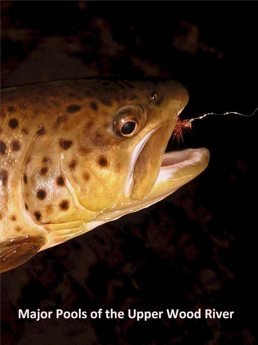
2 The upper section of the Wood River that runs approximately two miles downstream from the bridge on State Route 165 contains a number of significant pools. Although the river is constantly changing through the seasons in the annual cycle of flood and low water, these pools have maintained their characteristic positions, shapes, and sizes over a time sufficiently long enough that they have been given unofficial names by those who frequent them. These names have been passed on by word-of-mouth along with reports of catches, insect hatches, and water conditions but not every fisherman knows them. This effort is meant to save that information for the record and to share it among those who pursue the trout. The map below indicates nine major pools on this stretch of the river. Each pool is named and described briefly with latitude-longitude coordinates, a diagram giving a general impression of its characteristics, and photographs. Descriptions are written from a point of view at the head of the pool and looking downstream. Diagrams are schematic and depict the basic features that are unlikely to change very much. Water flow direction is shown by an arrow. Camera icons show the position and direction of the photographs. Thanks to Burt Strom, Dick Pearce, and Ed Lombardo, Sr. for their help and information. Further information about the pools is welcomed and comments or suggestions can be sent to gtboden@gmail.com. Gary Boden -March
3 Major Pools of the Upper Wood River 3
4 Pool 1 - Check Station Pool or Stone Bridge Pool N , W This pool lies immediately downstream from a stone bridge abutment in the center of the river. The right (west) bank is high and armored with large rocks. Stream width is about 30 feet and the pool length is about the same, gradually shallowing at the tail end. Check Station parking lot lies to the right (west) side. 4


5 Upstream view from tail-end of pool Cross-stream view 5
6 Pool 2 - Trico Pool N , W Three bends in the river create a series of pools. The upper pool starts with a right bend, stays narrow, and is stony under the left (east) bank. It opens into a broad, sandy-bottomed pool about 35 feet wide that arcs to the left. This pool then narrows to about 20 feet with a sand bar on the left. After a short run the river makes a sharp right bend into a trailing pool. 6


7 Upstream view of the first pool opening up into the large central pool Downstream view of the narrowing central pool 7
8 Pool 3 - High Banks Pool N , W This pool lies at the foot of an improved landing a short distance down from the parking area at the end of the Deep Pond Access road. Stream width is about 25 feet. This is the start of steeply-sloped high banks on the right (west) side. 8


9 Cross-stream view Downstream view from head of pool 9
10 Pool 4 - The S Pool N , W This pool makes an S-curve at the south end of the high banks stretch of shallow water and about 500 feet downstream from pool 3. A sharp left bend creates a small pool under the south side bank across from a sandbar. Stream width is about 15 feet. Several fallen trees lie in the back half of the pool as it makes a sharp right bend. 10


11 Downstream view from head of pool Downstream views of pool middle section 11
12 Pool 5 - Magic Pool N , W Upstream the channel hugs and undercuts the left (east) bank, gradually opening up into a broad, sandy-bottomed pool that shallows at the tail end. When water levels are low, a sandy beach is exposed on the right (west) side. A submerged rock lies in the channel opposite the beach. 12


13 Upstream view of undercut east bank Downstream view of undercut east bank and broad pool 13
14 Pool 6 - First Logjam Pool or Million Dollar Pool N , W This pool lies about 300 feet downstream from The Pines parking area. A sandy beach on right (west) side is exposed when water levels are low. Undercut banks, a deep pool and obstructions exist on left (east) side. 14


15 Cross-stream view from sandy beach Downstream view of pool 15
16 Pool 7 - The Mud Hole N , W A left bend about 200 feet downstream from pool 6 creates a pool with a shallow sandy left (east) bank. A canopy of trees shades the downstream half of this 20 foot wide pool. 16


17 Downstream view at mid-pool bend Upstream view from tail-end 17
18 Pool 8 - Brookie Alley or Canopy Pool N , W Numerous shallow pools run along a 300 foot stretch of undercut banks on left (east) side and overhanging vegetation. The right (west) side is generally sandy and shallow. 18


19 Upstream view of a pool and undercut east bank Downstream view of undercut east bank 19
20 Pool 9 - Second Logjam Pool or Cut Tree N , W Starting under a canopy of trees, this deep pool lies at a sharp left bend in the river. On the left (east) bank, fallen tree trunks stretch out from the bank. At the tail end of the pool the left side is shallow and sandy. 20


21 Upstream view from mid-pool bend Upstream view from tail-end of pool 21
SUMMARY OF MOVEMENT AND HABITAT USED BY TAGGED BROOK TROUT IN THE MAIN BRANCH AND NORTH BRANCH AU SABLE RIVER DURING SUMMER Data Submitted to:
 SUMMARY OF MOVEMENT AND HABITAT USED BY TAGGED BROOK TROUT IN THE MAIN BRANCH AND NORTH BRANCH AU SABLE RIVER DURING SUMMER 2014 Data Submitted to: Anglers of the Au Sable Submitted by: Dr. Mark R. Luttenton
Brook Trout Life Cycle and Habitat
 Brook Trout Life Cycle and Habitat Directions: 1. As you watch this slide show, watch for vocabulary terms we learned today. The first time they appear, you will see them in RED! (not redd!) 2. At the
Canoe Trip # Maps: 63L Amisk Lake 63M Pelican Narrows
 Canoe Trip #51 49 Southeast Arem Deschambault Lake - Pelican Narrows - Wunehikun Bay - Attitti Lake - Belcher Lake - Mukoman Lake - Ohoo Lake - Mukoman River - Sokatisewin Lake - Sandy Bay 170 Kilometers
River. Dynamics Canoeing: This section focuses on rivers; how they flow and on some basic maneuvers which you can execute on the river.
 This section focuses on rivers; how they flow and on some basic maneuvers which you can execute on the river. Dynamics Canoeing: By Robert B. Kauffman, Ph.D. 1 Topics - Laminar and shore to center flows
River Dynamics - Rafting FOCUS. Read 10 point text from rear of the room. Bottom
 Dynamics - Rafting FOCUS Read 10 point text from rear of the room. Bottom 1 This section focuses on rivers; how they flow and on some basic maneuvers which you can execute on the river. Dynamics Rafting:
DESCRIPTION OF THE CHELAN RIVER
 DESCRIPTION OF THE CHELAN RIVER The following information contains excerpts from the Whitewater Boating Feasibility Study conducted on the Chelan River in July, 2000. The Chelan River begins below the
Patuxent River Fishing Guide Trout Special Regulations Area, Near Damascus, MD
 Patuxent River Fishing Guide Trout Special Regulations Area, Near Damascus, MD Last Updated: March 2017 The Basics The Patuxent River near Damascus, Maryland is about 12 miles of Catch and Release water.
Stevens Creek Corridor
 O F F I C E O F T H E D I R E C T O R O F P U B L I C W O R K S Stevens Creek Corridor Creek Restoration Project Volume Three Project Update: Creek Photos, Before & After BY GAIL SEEDS - PROJECT MANAGER,
LAB: WHERE S THE BEACH
 Name: LAB: WHERE S THE BEACH Introduction When you build a sandcastle on the beach, you don't expect it to last forever. You spread out your towel to sunbathe, but you know you can't stay in the same spot
LITTLE ELKHART RIVER
 JUNE 014 OUTING LITTLE ELKHART RIVER Date: JUNE,014 Where: Little Elkart River in Middleburry, IN Lunch at 1:30 at River Bend Park Pavilion, Middlebury, IN. We will be grilling out the club will furnish
Coastal Processes and Landforms
 Coastal Processes and Landforms These icons indicate that teacher s notes or useful web addresses are available in the Notes Page. This icon indicates that the slide contains activities created in Flash.
STREAM SURVEY File form No..
 scanned for KRIS THE RESOURCES AGENCY OF CALIFORNIA California Department of Fish and Game STREAM SURVEY File form No.. Date: September 4, 1969. NAME: North Fork Schooner Gulch Creek COUNTY: Mendocino.
June 13, 2016 Tom Garigen Re: Myrtle Beach Golf and Yacht Club Drainage assessment
 INFRASTRUCTURE & REGULATION DIVISION- STORMWATER DEPARTMENT 4401 Privetts Road Conway, South Carolina 29526 Post Office Box 1236 Conway, South Carolina 29528-1236 Phone: (843) 915-5160 Fax: (843) 365-2208
JAP Additional Information Sheet
 JAP Additional Information Sheet Block 15: Purpose and Need The USACE purpose of the project is to provide a safe and reliable whitewater park for the recreational public in a city park, which will provide
Life at its Peak of Exuberance: Coral Reefs and Tropical Rainforests
 Life at its Peak of Exuberance: Coral Reefs and Tropical Rainforests Note: These links do not work. Use the links within the outline to access the images in the popup windows. This text is the same as
Canoe Trip # Length of Trip: 225 kilometres Time Required to Complete Trip: 10 to 14 days Number of Portages: 21 to 25
 Canoe Trip #34 34 Brabant Lake - Wapiskau River - Steephill Lake - Reindeer River - Churchill River - Sandy Bay 225 Kilometers - 10 to 14 days - 21 to 25 portages Length of Trip: 225 kilometres Time Required
Cross-Vane Plan View FIN-UP Habitat Consultants, Inc. 220 Illinois Avenue Manitou Springs, CO (719) P.
 P.") STREAM CHANNEL STRUCTURE DRAWINGS ISIONS W (Channel Width) (Varies) Thalweg & Flow Direction Individually Placed Footer Rocks 5' to 6' by 2' thick (Min. 2 rows of footer rocks placed tightly together with
STREAM CHANNEL STRUCTURE DRAWINGS ISIONS W (Channel Width) (Varies) Thalweg & Flow Direction Individually Placed Footer Rocks 5' to 6' by 2' thick (Min. 2 rows of footer rocks placed tightly together with
Emergent Sandbar Habitat Program Middle Missouri River
 Emergent Sandbar Habitat Program Middle Missouri River Jeremiah Szynskie, P.E. Hydrologic Engineering Branch Introduction Main Stem System Dam Closures Fort Peck 1937 Fort Randall 1952 Garrison - 1953
STREAM CLASSIFICATION AND MAPPING. Prepared For. MacMillan Bloedel Ltd. Menzies Bay Division BOX 6000, Campbell River V9W 5E1.
 STREAM CLASSIFICATION AND MAPPING OF STREAMS IN MENZIES AND OYSTER BAY Prepared For MacMillan Bloedel Ltd. Menzies Bay Division BOX 6000, Campbell River V9W 5E1 September 1998 a a North Island Biological
Thornton le Dale Walks
 Thornton le Dale Walks A collection of walks in and around the village Thornton le Dale Traders Forum www.visitthorntonledale.co.uk Thornton le Dale Walks Walk 1: Beck Isle Cottage and All Saints Church
THE RESOURCES AGENCY OF CALIFORNIA Department of Fish and Game STREAM SURVEY
 File form No.. Date: 4/1/73. NAME: Maacama Creek COUNTY: Sonoma. STREAM SECTION: FROM: Maacama Creek Ranch TO: Chalk Hill Rd. Bridge LENGTH: 1.5 mi.. Bridge OTHER NAMES: Weather - Clear & Sunny RIVER SYSTEM:
Coasts. 1. Coastal Processes. 1.1 Coastal erosion. 1.2 Sediment transport. Coastal Processes and Landforms. i. Hydraulic action
 Coasts Coastal Processes and Landforms 1. Coastal Processes 1.1 Coastal erosion i. Hydraulic action When waves strike against a rock surface, the waves trap air in the rock joints. This air is compressed
Storm Damage Floating Culverts & Other Inlet Issues
 Storm Damage Floating Culverts & Other Inlet Issues Mark Bailey, PE - Hydraulic Manager, INDOT Dale Sedler, PE - Sr. Hydraulic Engineer, INDOT Road School 2016 What causes a culvert to float? 1. Accumulation
ST. LOUIS SECTION PROJECT OF THE YEAR AWARD
 ST. LOUIS SECTION PROJECT OF THE YEAR AWARD Originality and Innovation The St. Louis Harbor Project is located in the Upper Mississippi River between the entrance to the Chain of Rocks Canal at River
The Mendip Way. Route Directions and Maps Wells to Frome
 The Mendip Way Route Directions and Maps Wells to Frome Website: www.mendiphillsaonb.org.uk Email: mendip@mendiphillsaonb.org.uk Facebook & Twitter: @MendipHillsAONB Phone: 01761462338 1 Wells to Shepton
REPORT TO THE MINISTER OF NATURAL RESOURCES. Pursuant to an appointment made by the Honourable Frank S. Miller, Minister of Natural
 Room 569, Fifth Floor, Mowat Block, Queen's Park, Toronto, Ontario. M7A la2 IN THE MATTER OF The Lakes and Rivers Improvement Act; AND IN THE MATTER OF An application by Rudolph Adam for approval under
Canoe Route. Dogtooth Lake-Highwind Lake-Dryberry Lake- Lake of the Woods-Blindfold Lake
 1 Canoe Route Dogtooth Lake-Highwind Lake-Dryberry Lake- Lake of the Woods-Blindfold Lake This is an interesting and challenging route starting and ending at Rushing River Provincial Park. It passes over
Highland Region MAP. No. 11 St. Marys River No. 12 West River No. 13 Wallace River No. 14 Toney River No. 15 Northumberland Strait
 Highland Region MAP No. 11 St. Marys River No. 12 West River No. 13 Wallace River No. 14 Toney River No. 15 Northumberland Strait 14 Route: No. 11 St. Marys River Rating: Intermediate Advanced Length:
Upstreampaddle 25.South arm of the Brunswick River, Simpson s Creek drains the freshwater swamp lands of Tyagarah Nature Reserve, 750 hectares. Furthe
 Upstreampaddle 24 The Brunswick River is a shorter length river on the coastal plain of Northern New South Wales. The areas of interest to canoeists are: the reach from the town of Mullumbimby down to
Coyote Buttes/The Waves
 Coyote Buttes/The Waves Ron Ross December 22, 2007 Coyote Buttes is located in the Paria Canyon-Vermilion Cliffs Wilderness just south of US 89 about halfway between Kanab, Utah and Page, Arizona. The
BENSON PARK POND FISH SPECIES
 BENSON PARK POND FISH SPECIES Bluegill (Lepomis macrochirus) From the Greek, lepomis means scaled gill cover and macrochirus means large hand, in reference to its body shape and size. Average adult size
Booklet translated by SREJ at CSDC 1
 Name: Gr. : Booklet translated by SREJ at CSDC 1 This is the beginning of a new project about Aquaculture. Before we start, I would like to see what you already know about the subject. Write all the words
THE BECK STONE Backstone Beck on Ilkley Moor
 THE BECK STONE Backstone Beck on Ilkley Moor 1 Three different routes which take in the best of the lower slopes of Ilkley Moor, with bracken, heather, a tarn (a small mountain lake) and rushing streams.
Warm-up # 7 A day 5/17 - B day 5/18 UPDATE YOUR TABLE OF CONTENTS
 Warm-up # 7 A day 5/17 - B day 5/18 UPDATE YOUR TABLE OF CONTENTS Question: List all examples of surface water on Earth. Answer: Rivers and streams, lakes and reservoirs, (ponds) wetlands, estuaries and
feeding - downstream sections of large rivers, lakes, and impoundments
 River Assessment Appendix Shorthead redhorse (Moxostoma macrolepidotum) feeding - downstream sections of large rivers, lakes, and impoundments - rocky substrates - swift water near riffles - clear to slightly
Fish population survey report
 Fish population survey report Upper River Avon Catchment This report provides a summary of results from recent fish population surveys on the Tetbury Avon, Sherston Avon and River Marden The surveys were
The Case of the Disappearing Shoreline
 Name The Case of the Disappearing Shoreline Humans change the earth's climate in many ways. One change is the increase of carbon dioxide in the atmosphere. As we burn more fossil fuels, we release more
General Coastal Notes + Landforms! 1
 General Coastal Notes + Landforms! 1 Types of Coastlines: Type Description Primary Coast which is essentially in the same condition when sea level stabilized Coastline after the last ice age, younger.
Culvert Design for Low and High Gradient Streams in the Midwest. Dale Higgins, Hydrologist Chequamegon-Nicolet National Forest
 Culvert Design for Low and High Gradient Streams in the Midwest Dale Higgins, Hydrologist Chequamegon-Nicolet National Forest Overview Culvert Design Considerations Hydraulic Terms Culvert Impacts Low
EXTENT OF OBSERVATION
 scanned for KRIS THE RESOURCES AGENCY OF CALIFORNIA Department of Fish and Game STREAM SURVEY Date: May 25 and 31, 1977. NAME: Unnamed Stream (Tributary to Sonoma Creek) COUNTY: Sonoma. STREAM SECTION:
NWS 44: Mining Activities Location #1, Stanislaus River
 NWS 44: Mining Activities Location #1, Stanislaus River Permit is for the use of a single 8 dredge on a federal mining claim at the location described on the map and as Twp 02N Range 14E, Section 04, MDM
WHAT ARE THE MAJOR COASTLINE FEATURES AND WAVE CHARACTERISTICS WHICH INDICATE THAT MARINE EROSION IS ACTIVE ON THE EASTERN SIDE OF THE
 WHAT ARE THE MAJOR COASTLINE FEATURES AND WAVE CHARACTERISTICS WHICH INDICATE THAT MARINE EROSION IS ACTIVE ON THE EASTERN SIDE OF THE ENTRANCE TO DISCOVERY BAY HARBOUR IN JAMAICA? JEFFREY JOHNSON YORK
KYLE OF SUTHERLAND ANGLING ASSOCIATION.
 KYLE OF SUTHERLAND ANGLING ASSOCIATION. VIRTUAL GHILLIE SALMON The Kyle of Sutherland offers some of the finest Salmon estuary fishing in the country. when the weather is dry, and the rivers are low, salmon
Examples of estuaries include bays, sounds, salt marshes, mangrove forests, mud flats, swamps, inlets, and sloughs.
 An estuary is a partially enclosed body of water where incoming seawater is mixed with fresh water coming from the land. Examples of estuaries include bays, sounds, salt marshes, mangrove forests, mud
VIMS CCRM Coastal Management Decision Tools. Decision Tree for Undefended Shorelines and Those with Failed Structures
 VIMS CCRM Coastal Management Decision Tools Decision Tree for Undefended Shorelines and Those with Failed Structures Center for Coastal Resources Management Virginia Institute of Marine Science Gloucester
RESILIENCE THROUGH RESTORATION
 RESILIENCE THROUGH RESTORATION RECLAMATION DISTRICT NO. 1601 TWITCHELL ISLAND SAN JOAQUIN RIVER SETBACK LEVEE PROJECT TWITCHELL ISLAND BASICS Nearly 12 miles of levee Storm drainage facilities Protects
Danbury Words and pictures by Laurie Page of the Public Rights of Way team at Essex County Council.
 Danbury Words and pictures by Laurie Page of the Public Rights of Way team at Essex County Council. An undulating walk from Danbury village to the bluebells at the National Trust property of Blakes Wood.
APPENDIX A STRUCTURE DESCRIPTIONS AND RATING CURVES
 3 4 5 6 7 8 9 0 3 APPENDIX A STRUCTURE DESCRIPTIONS AND RATING CURVES Kissimmee River Vol December 005 Version Draft 4 3 4 5 6 7 8 9 0 3 4 5 6 7 8 9 0 3 4 5 6 7 8 9 30 3 3 33 34 35 36 37 38 39 40 4 4 43
RIVERS KIDS HOPE AUS. THEMED MENTOR HOUR. Background: Interesting River Facts
 KIDS HOPE AUS. THEMED MENTOR HOUR RIVERS Background: Interesting River Facts The longest river in the world is the Nile River, it reaches around 6650 kilometers in length (4132 miles). More Nile River
THE RIVER ALUN (aka ALYN)
") THE RIVER ALUN (aka ALYN) Advisory Visit Report Undertaken On behalf of the Wild Trout Trust By Ron Holloway MIFM 22 nd April 2002-04-25 The River Alun The Rossett & Gresford Fly Fishing Club R H Associates
THE RIVER ALUN (aka ALYN) Advisory Visit Report Undertaken On behalf of the Wild Trout Trust By Ron Holloway MIFM 22 nd April 2002-04-25 The River Alun The Rossett & Gresford Fly Fishing Club R H Associates
Thornton le Dale Walks
 Thornton le Dale Walks A collection of circular walks in, and around, the village www.visitthorntonledale.co.uk Thornton-le-Dale Traders Forum and Thornton le Dale Parish Council 1 Thornton le Dale Circular
Finally Out of the Sand
 Finally Out of the Sand A Guide to Success in the Bunker Written By: Master Teaching Professional Adam Kolloff www.scratchgolfschool.com Introduction I can't tell you how many people roll their eyes when
Glenbrook and Euroka Circuit
 Glenbrook and Euroka Circuit 2 Days 16.6 km Circuit Experienced only 790m This two day circuit, returning to Glenbrook Station, is a scenic walk which passes many of the tourist attractions within the
Preakness Brook - FIBI098
 Preakness Brook - FIBI098 Preakn ess B rook Preakness " ( FIBI098 Naachtpunkt Brook 202 80 IBI Ratings FIBI Sampling Location Excellent Small Streams (1st and 2nd Order) Good Fair Large Streams (3rd Order
Winter Drawdown Issues of Concern
 Winter Drawdown Issues of Concern Wetland Connectivity Amphibians Fisheries Winter Drawdown Wetland Connectivity Wetland complex near Osprey Creek is not responsive to lake level Wetland at upper end of
Waters rise and fall in tides.
 Page 1 of 5 KEY ONEPT Waters rise and fall in tides. BEFORE, you learned Wind provides the energy to form waves in the ocean Ocean waves change near shore The ocean is a global body of water NOW, you will
then extrapolated to larger area just based on the length of bank [that actually falls in this category].
![then extrapolated to larger area just based on the length of bank [that actually falls in this category].](/thumbs/73/69159506.jpg "then extrapolated to larger area just based on the length of bank [that actually falls in this category].") Ken Rood: Good morning, all. You'll probably be glad to know I'm the last speaker of the day. I'm never sure if that's a good thing or not. But [lucky me]. And I'm going to talk today -- the title of the
Ken Rood: Good morning, all. You'll probably be glad to know I'm the last speaker of the day. I'm never sure if that's a good thing or not. But [lucky me]. And I'm going to talk today -- the title of the
Juvenile Steelhead and Stream Habitat Conditions Steelhead and Coho Salmon Life History Prepared by: DW ALLEY & Associates, Fishery Consultant
 Juvenile Steelhead and Stream Habitat Conditions Steelhead and Coho Salmon Life History Prepared by: DW ALLEY & Associates, Fishery Consultant I-1. Steelhead and Coho Salmon Ecology Migration. Adult steelhead
Summary of HEC 18, Evaluating Scour at Bridges FHWA NHI Should really follow HEC 18, but this summary will get you the main points.
 Summary of HEC 18, Evaluating Scour at Bridges FHWA NHI 01-001 Should really follow HEC 18, but this summary will get you the main points. 1: Determine scour analysis variables 2: Analyze long-term bed
UNDERWATER BRIDGE INSPECTION REPORT DISTRICT 1 PINE COUNTY
 UNDERWATER BRIDGE INSPECTION REPORT STRUCTURE NO. 58551 CSAH NO. 41 OVER THE KETTLE RIVER DISTRICT 1 PINE COUNTY JULY 28, 2012 PREPARED FOR THE MINNESOTA DEPARTMENT OF TRANSPORTATION BY COLLINS ENGINEERS,
HURON RIVER WATERSHED
 Brown bullhead (Ameiurus nebulosus) feeding - larger streams and rivers, lakes and impoundments - clear cool water with little clayey silt - moderate amounts of aquatic vegetation - sand, gravel, or muck
Appendix A Photo Set
 Appendix A Photo Set Fish Habitat Inventory, Mattamy Richmond Lands, Spring 2009 Submitted To: Susan Murphy Mattamy Homes 123 Huntmar Drive Ottawa, Ontario K2S 1B9 KILGOUR & ASSOCIATES LTD. 1500 Bank Street,
River-Lab Grade 3 (RL3) Route Green & Yellow Deep River Pool Trail Guide
 Route Green & Yellow Deep River Pool Trail Guide") River-Lab Grade 3 (RL3) Route Green & Yellow Deep River Pool Trail Guide Route Green & Yellow Deep River Pool Trail Route Sequence Deep Pool Habitat Observation Marsh Habitat Observation Riffles Habitat
River-Lab Grade 3 (RL3) Route Green & Yellow Deep River Pool Trail Guide Route Green & Yellow Deep River Pool Trail Route Sequence Deep Pool Habitat Observation Marsh Habitat Observation Riffles Habitat
Faulconbridge to Blaxland
 Faulconbridge to Blaxland 2 Days Experienced only 15.2 km One way 5 693m This two-day walk, or very solid one-day walk, takes you from station to station, through lush, scenic forest in the lower Blue
Fish Friendly Crossings- Examples from Nash Stream
 Fish Friendly Crossings- Examples from Nash Stream Maggie Machinist- North Regional Forester, Division of Forests and Lands. Nash Stream Nash Stream Forest is 40,000 acres, owned and managed by NH Division
Rehabilitation of Grimes Creek, a Stream Impacted in the Past by Bucket-lined Dredge Gold Mining, Boise River Drainage, July 2008 to August 2011.
 Rehabilitation of Grimes Creek, a Stream Impacted in the Past by Bucket-lined Dredge Gold Mining, Boise River Drainage, July 2008 to August 2011. Pam Harrington TU,1020 W. Main Street Suite 440, Boise,
If you have comments on this or suggestions for other terms that should be added to this glossary, please send an to
 Tide Gates Glossary There is very little information available anywhere related to tide gates and flap gates. This is a glossary of terms that are associated with, or useful when discussing, tide gates.
Outdoor Recreation Unit. Obj. 8, 9, 10
 Outdoor Recreation Unit Obj. 8, 9, 10 Fishing Equipment and Styles Fishing line Buy good quality line Select a proper test for expected fishing type Proper line for reel Line types Bait casting: braided
GUIDED IMAGERY. Young children imagine the life of a salmon in the wild. LEARNING OBJECTIVES WHAT TO DO
 GUIDED IMAGERY Young children imagine the life of a salmon in the wild. LEARNING OBJECTIVES Develop listening skills. Understand a life process and that it is a cycle. Begin to understand how pollution
Quillback (Carpoides cyprinus)
") t. Joseph Assessment Appendix Quillback (Carpoides cyprinus) feeding - clear to turbid water - Michigan - sand, sandy gravel, sandy silt, or clay-silt substrate - medium- to low-gradient rivers and streams;
t. Joseph Assessment Appendix Quillback (Carpoides cyprinus) feeding - clear to turbid water - Michigan - sand, sandy gravel, sandy silt, or clay-silt substrate - medium- to low-gradient rivers and streams;
What does science tell us about Tuna? Tuna biology.101. Erica Williams, Jacques Boubée & Wakaiti Dalton
 What does science tell us about Tuna? Tuna biology.101 Erica Williams, Jacques Boubée & Wakaiti Dalton Types of tuna Anguillidae (Tuna, Puhi, Anguilliformes) is the family name of fish that includes all
SteerCert Objective. Detailed knowledge of Contents of key selected rules from ColRegs and PLA Byelaws Contents of Tideway Rowing Rules
 SteerCert Objective Detailed knowledge of Contents of key selected rules from ColRegs and PLA Byelaws Contents of Tideway Rowing Rules Knowledge of Right of way Signals Bridge passing guidelines Overtaking
INTRODUCTION TO STRUCTURE FISHING: IDENTIFICATION OF FISH LOCATIONS STRUCTURE FISHING
 INTRODUCTION TO STRUCTURE FISHING: IDENTIFICATION OF FISH LOCATIONS Featuring: - Migration Theory of fish. - Structure types: Point Bar Underwater Hump Channel Man Made - Understanding Breaks & Breaklines
Detailed maps, and portaging and camping information follow.
 Overview of Bain route. The launch site is at Davidson Lake, just before the Manitoba/Ontario border. You can do a loop if you leave a vehicle at Tulabi Lake (at the canoe route parking lot). The road
Beautiful Walks from the Blue Ball Inn
 Walk No. 7 COAST AND VALLEY WALK Countisbury, Glenthorne, County Gate, Brendon, Rockford and Wilsham 10 MILES APPROX. Walking time 5 hours approx. (not including breaks)> OS Sheet 64/74 Lynton and Lynmouth.
Julebæk Strand. Effect full beach nourishment
 Julebæk Strand Effect full beach nourishment Aim of Study This study is a part of the COADAPT funding and the aim of the study is to analyze the effect of beach nourishment. In order to investigate the
Define the key terms: - Abrasion - Attrition - Hydraulic action - Solution. Y11 Coasts
 Define the key terms: - Abrasion - Attrition - Hydraulic action - Solution Abrasion caused by waves picking up material which is forced against the cliff face wearing it away Attrition where stones and
NATURAL RESOURCES WALES / RESCUE 3 EUROPE WEIR ASSESSMENT SYSTEM
 EUROPE NATURAL RESOURCES WALES / RESCUE 3 EUROPE WEIR ASSESSMENT SYSTEM Name of assessor: Date of assessment: WEIR INFORMATION Name of weir / site: Other names weir known as: Weir location and river: Grid
Reading Material. Inshore oceanography, Anikouchine and Sternberg The World Ocean, Prentice-Hall
 Reading Material Inshore oceanography, Anikouchine and Sternberg The World Ocean, Prentice-Hall BEACH PROCESSES AND COASTAL ENVIRONMENTS COASTAL FEATURES Cross section Map view Terminology for Coastal
Launch A: Experimental Lakes Road The launch site is about 4 km from highway #17. There is a sign on the highway indicating the experimental lakes
 Launch A: Experimental Lakes Road The launch site is about 4 km from highway #17. There is a sign on the highway indicating the experimental lakes road. You have to cross railway tracks on the way to the
Geography of the Lower Fitzroy and navigation problems
 Geography of the Lower Fitzroy and navigation problems A topographic map of the Fitzroy estuary readily indicates why the Fitzroy River has proved difficult for shipping to negotiate. The river meanders
Micro Hydropower and Fish.
 Micro Hydropower and Fish. Garry O Neill. Senior Fisheries Officer. Inland Fisheries Branch. 1. Value of Fisheries. 2. Life cycle of the Salmon. 3. Potential impacts of Hydro s on Fish. 4. Fisheries Legislation.
Beaver Brook - FIBI047 Hope
 Beaver Brook - FIBI047.-,80 Silve r Lake Mud dy Br ook % Hope Honey Run Beaver Brook FIBI047 #S #S FIBI Sampling Location Small Streams (1st and 2nd Order) Large Streams (3rd Order and Above) N 0 1 2 3
HY-8 Version 7.2 Build Date January 17, Federal Highway Administration.
 HY-8 Version 7.2 Build Date January 17, 2012 Federal Highway Administration http://www.fhwa.dot.gov/engineering/hydraulics/software/hy8/index.cfm SIMPLE Simple to use Use for simple culverts and bridges
1. Kala Nera Milies Kala Nera
 1. Kala Nera Milies Kala Nera A beautiful and varied walk from Kala Nera, a tourist seaside village, to Milies which lies 400 metres higher up. From there it proceeds back down to Kala Nera along another
Huntington District. For More Information Contact (304)
") Zoar Levee & Diversion Dam are located in the Muskingum River Basin highlighted in green to left. The Muskingum River Basin is the site of Ohio s first multiple purpose water management and land conservation
Zoar Levee & Diversion Dam are located in the Muskingum River Basin highlighted in green to left. The Muskingum River Basin is the site of Ohio s first multiple purpose water management and land conservation
1.5 Understand how ocean waves and currents change the face of coastal areas. (Chapter 3)
") 1.5 Understand how ocean waves and currents change the face of coastal areas. (Chapter 3) 1. Hydraulic Action/Pressure - air being forced into crack in rocks. 2. Corrosion (Solution) Minerals such as calcium
1.5 Understand how ocean waves and currents change the face of coastal areas. (Chapter 3) 1. Hydraulic Action/Pressure - air being forced into crack in rocks. 2. Corrosion (Solution) Minerals such as calcium
Fly Fishing for Trout in Southeast Minnesota Streams
 Fly Fishing for Trout in Southeast Minnesota Streams Fly Fishing for the First Time? Equipment Basics Mid-weight fly rod, 5 or 6 weight, with fly line to match Reel Leader Extra tippet Flies Glasses or
CHAPTER X: PORTAGES AROUND DAMS
 CHAPTER X: PORTAGES AROUND DAMS A. General Description Portages are land routes used by paddlers to transport their boats to and from a launch area or between access sites. Often located along water bodies
Water Habitat Model. Outcome: Materials: Teacher Instructions: : Identify the components of an animal habitat..
 Water Habitat Model Outcome: 4-1-03: Identify the components of an animal habitat.. Materials: Shoe boxes (1 per student) Art supplies: Glue and/or tape Paint and brushes for the background Plasticine/clay
For more information or permission to reprint slides, please contact Donna Milligan at 1
 For more information or permission to reprint slides, please contact Donna Milligan at milligan@vims.edu 1 For more information or permission to reprint slides, please contact Donna Milligan at milligan@vims.edu
LOWER BODY REHABILITATION CONDITIONING EXERCISES
 LOWER BODY REHABILITATION CONDITIONING EXERCISES GENERAL INSTRUCTIONS: The exercises below are to be performed on your involved and injured leg. Do the exercises slowly and relax between each one. Do not
Salmon Run ~ by Ted Boretti
 Salmon Run ~ by Ted Boretti In early morning, the water of the river moves slowly so slowly the water looks like glass. The air is still cold from the night. Mist rises from the river like smoke. I slide
Experience. Fly Fishing Small Streams Tactics, Strategies & Where to Go. Jan Hackett Duke University
 Fly Fishing Small Streams Tactics, Strategies & Where to Go Jan Hackett Duke University Experience Instructor Duke University since 1999 NC Anglers 1995-2002 Professional Guide & Fly Tier Orvis endorsed
EXAMPLES (OPEN-CHANNEL FLOW) AUTUMN 2018
 AUTUMN 2018") EXAMPLES (OPEN-CHANNEL FLOW) AUTUMN 2018 Normal and Critical Depths Q1. If the discharge in a channel of width 5 m is 20 m 3 s 1 and Manning s n is 0.02 m 1/3 s, find: (a) the normal depth and Froude number
EXAMPLES (OPEN-CHANNEL FLOW) AUTUMN 2018 Normal and Critical Depths Q1. If the discharge in a channel of width 5 m is 20 m 3 s 1 and Manning s n is 0.02 m 1/3 s, find: (a) the normal depth and Froude number
UNDERSTANDING YOUR ESTUARY Level IA- ESTUARY SEARCH
 UNDERSTANDING YOUR ESTUARY Level IA- ESTUARY SEARCH Kakagon/Bad River Sloughs, a Lake Superior estuary located on the Bad River Reservation near Ashland, WI. GOAL Select one Wisconsin estuary to study
UNDERWATER BRIDGE INSPECTION REPORT STRUCTURE NO MSAS 123 (2 ND AVE. SW) OVER THE CANNON RIVER CITY OF FARIBAULT, RICE COUNTY
 OVER THE CANNON RIVER CITY OF FARIBAULT, RICE COUNTY") UNDERWATER BRIDGE INSPECTION REPORT STRUCTURE NO. 66546 MSAS 123 (2 ND AVE. SW) OVER THE CANNON RIVER CITY OF FARIBAULT, RICE COUNTY SEPTEMBER 13, 2012 PREPARED FOR THE MINNESOTA DEPARTMENT OF TRANSPORTATION
UNDERWATER BRIDGE INSPECTION REPORT STRUCTURE NO. 66546 MSAS 123 (2 ND AVE. SW) OVER THE CANNON RIVER CITY OF FARIBAULT, RICE COUNTY SEPTEMBER 13, 2012 PREPARED FOR THE MINNESOTA DEPARTMENT OF TRANSPORTATION
Creek Trash Assessment (CTA) Methodology (Demonstration: Mill Run Creek, Cheltenham, Pa.)
 Methodology (Demonstration: Mill Run Creek, Cheltenham, Pa.)") Creek Trash Assessment (CTA) Methodology (Demonstration: Mill Run Creek, Cheltenham, Pa.) Mill Run Creek emerges from a storm sewer in Philadelphia to an open creek in Cheltenham. The Creek downstream
Creek Trash Assessment (CTA) Methodology (Demonstration: Mill Run Creek, Cheltenham, Pa.) Mill Run Creek emerges from a storm sewer in Philadelphia to an open creek in Cheltenham. The Creek downstream
UNDERWATER BRIDGE INSPECTION REPORT STRUCTURE NO B WABASHA STREET SOUTH BOUND (MASA 235 SB)
") UNDERWATER BRIDGE INSPECTION REPORT STRUCTURE NO. 62555B WABASHA STREET SOUTH BOUND (MASA 235 SB) OVER THE MISSISSIPPI RIVER CITY OF ST. PAUL OCTOBER 31, 2012 PREPARED FOR THE MINNESOTA DEPARTMENT OF TRANSPORTATION
UNDERWATER BRIDGE INSPECTION REPORT STRUCTURE NO. 62555B WABASHA STREET SOUTH BOUND (MASA 235 SB) OVER THE MISSISSIPPI RIVER CITY OF ST. PAUL OCTOBER 31, 2012 PREPARED FOR THE MINNESOTA DEPARTMENT OF TRANSPORTATION
Fish Passage Assessment Report Mare Brook Culverts
 Fish Passage Assessment Report Mare Brook Culverts Fish Passage Assessment Component of Mare Brook Watershed Assessment and Community Engagement Project Prepared for: FB Environmental Associates 97A Exchange