Evaluation of Placement Alternatives for Matagorda Ship Channel Bottleneck Removal
|
|
|
- Kenneth Todd
- 5 years ago
- Views:
Transcription


1 Evaluation of Placement Alternatives for Matagorda Ship Channel Bottleneck Removal James Rosati III Ashley E. Frey CPT Grays Harbor, WA Wood Wood chips Flour Other CMS Shark River Inlet, NJ US Army Corps of Engineers BUILDING STRONG Draft, ft GenCade Matagorda Ship Channel, TX 1


2 Project Location Texas Houston LA Galveston Bay Galveston Island Matagorda Bay E. Matagorda Bay Corpus Christi Matagorda Ship Channel San Antonio Bay Copano Bay Corpus Christi Bay Baffin Bay Mexico Brownsville 120 mi 240 mi 2
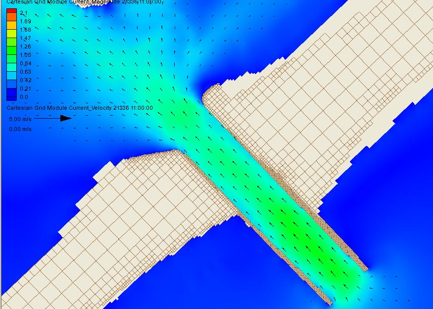
3 Relevant Facts Authorized depth 36ft channel - 38ft Bar Channel has scour holes in the ft deep between jetties Rated one of the most problematic in US for Nav. Max current exceeds 3 knots 60% of the time Max current exceeds 5 knots 20% of the time Cross currents an issue Bottleneck has minimum width of 950ft Port Tonnage ranks between 50 and 100 in US Designed with fixed bed physical model Construction completed

4 Selected Previous ERDC/CHL Technical Reports to Present DMS Report Jetty Stability Study Pass Cavallo Study Risks to Navigation Placement alternatives; Summer 2008 and Winter 2004 conditions from previous studies Field Measurements, circulation modeling, Shoreline change, Ship Simulator study, risk analysis. But no combined wind, wave, hydrodynamic, and morphology approach for Sundown Island until now. 4
 beneficially Sundown Island Beach Placement")
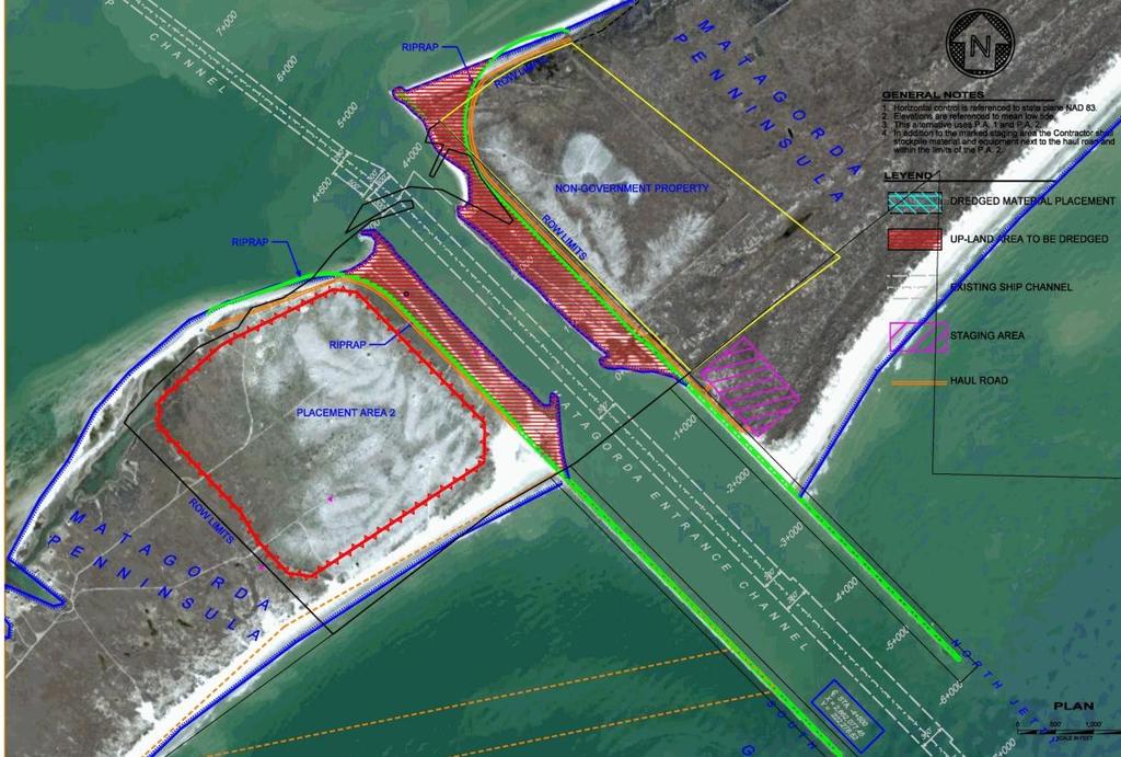
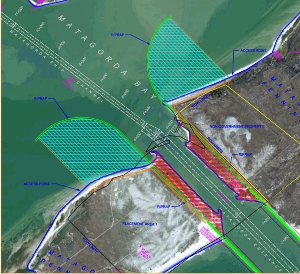
5 Study Objectives Remediate design deficiency Use 5.3 Mcy material (fine-med sand) beneficially Sundown Island Beach Placement Minimal impact on: GIWW Pass Cavallo 5

6 Bottleneck Alternatives 6

7 Coastal Modeling System Telescoping Grid 7
8 Reduced, Previously Proposed Flanges 8

9 MSC Validation Water Levels 9

10 MSC Validation - Currents 10

11 Sundown Island May,
12 Current Speed Results (Summer 2008) Alt - All but Existing have bottleneck removed Island/Beach (Mcy) Max Flood Current (along channel) Max Flood Cross Current Max Ebb Current (along channel) Max Ebb Cross Current Existing / / /
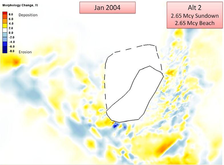
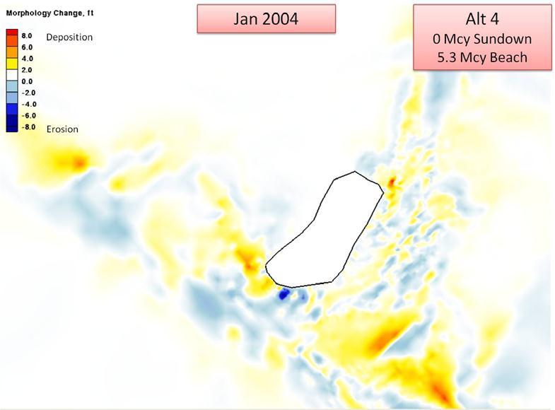
13 Morphology Change 13

14 Waves Full Plane Results 14

15 GIWW(s) 15

16 Sundown Island - Shore Protection? Costs a concern 16

 Storm")

17 GenCade Applicability Regional processes, Long-term morphology change Project Planning & Design Habitat Change Regional Sediment Management Beach fills Inlet bypassing Channel maintenance Unifying technology for multiple projects Intuitive interface (SMS) Storm erosion hazard management Dune erosion, overwash, & breach susceptibility; coastal response to SLR Habitat evolution (Piping Plover; vegetation)
18 GenCade Setup and Alternatives Estimate shoreline change and longshore transport south of south jetty on Matagorda Peninsula Mean grain size = 0.18 mm Waves from Buoy of NOAA National Data Buoy Center Eleven year record, Repeated wave record in GenCade after 11 years Alt 1 Alt 2 Alt 3 Alt 4 GenCade Alternatives Existing Condition, No Action 2.65 Mcy Beach Placement 4.0 Mcy Beach Placement 5.3 Mcy Beach Placement

19 GenCade Results Alt 1 No Action Present Shoreline Calculated Shoreline Years
20 GenCade Results Alt 1 No Action Note: K cy/yr
21 GenCade Alt Mcy Placement Present Shoreline Calculated Shoreline Years Beach Placement, 2.65 Mcy
22 GenCade Alt Mcy Placement
23 GenCade Alt 3 4 Mcy Placement Present Shoreline Calculated Shoreline Years Beach Placement, 4 Mcy
24 GenCade Alt 3 4 Mcy Placement
25 GenCade Alt Mcy Placement Present Shoreline Calculated Shoreline Years Beach Placement, 5.3 Mcy
26 GenCade Alt Mcy Placement
27 Pass Cavallo Inlet Width 27
28 Conclusions Expansion of Sundown Island did not significantly increase MSC cross-channel current velocity. Shore protection recommended to help limit influence on intracoastal waterway and ship channel All alternatives for beach placement are considered viable. Pass Cavallo expected to remain stable South jetty stabilization also a benefit. Removal of the bottleneck decreased currents relative to the existing condition both along the channel axis and cross-channel currents 28

29 Questions? 29
Coastal and Hydraulics Laboratory
 ERDC/CHL TR-11-2 Coastal Inlets Research Program Analysis of Dredged Material Placement Alternatives for Bottleneck Removal, Matagorda Ship Channel, Texas James Rosati III, Ashley E. Frey, Mitchell E.
Follets Island Nearshore Beach Nourishment Project
 Coast & Harbor Engineering A division of Hatch Mott MacDonald Follets Island Nearshore Beach Nourishment Project Arpit Agarwal, P.E. April 1, 2016 Project Site!"#$% &'(% &)*+% )#,'-+% Shoreline Erosion
Nearshore Dredged Material Placement Pilot Study at Noyo Harbor, CA
 1 Nearshore Dredged Material Placement Pilot Study at Noyo Harbor, CA Noyo Cove N 2011 National Conference on Beach Preservation Technology 9-11, February 2011 Lihwa Lin, Honghai Li, Mitchell Brown US
GenCade Applications Ashley Frey
 GenCade Applications Ashley Frey Research Civil Engineer, Co-PI of the Inlet Engineering Toolbox work unit of CIRP Report Documentation Page Form Approved OMB No. 0704-0188 Public reporting burden for
Tanya M. Beck. Kelly Legault. Research Physical Scientist Coastal & Hydraulics Lab, ERDC Vicksburg, MS
 Inlet And Adjacent Shoreline Processes at Cascading Time Scales Using the Coastal Modeling System and GenCade Tanya M. Beck Research Physical Scientist Coastal & Hydraulics Lab, ERDC Vicksburg, MS Kelly
Inlet Management Study for Pass-A-Grille and Bunces Pass, Pinellas County, Florida
 Inlet Management Study for Pass-A-Grille and Bunces Pass, Pinellas County, Florida Final Report Submitted By Ping Wang, Ph.D., Jun Cheng Ph.D., Zachary Westfall, and Mathieu Vallee Coastal Research Laboratory
CALCASIEU SALINITY STRUCTURES. HYDRODYNAMIC MODELING (To Support Design of Salinity Barriers)
") CALCASIEU SALINITY STRUCTURES HYDRODYNAMIC MODELING (To Support Design of Salinity Barriers) Presentation Overview 1 2 3 4 5 Project Overview and CEA Circulation Modeling Vessel Hydrodynamics Modeling
CALCASIEU SALINITY STRUCTURES HYDRODYNAMIC MODELING (To Support Design of Salinity Barriers) Presentation Overview 1 2 3 4 5 Project Overview and CEA Circulation Modeling Vessel Hydrodynamics Modeling
Assateague Island National Seashore North End Restoration Project Timeline
 Assateague Island National Seashore North End Restoration Project Timeline Date Event Some information provided in the Project Introduction document. Detailed events are available in a timeline compiled
FY-16 Ongoing Contracts FY-16 Scheduled Contracts
 FY-16 Ongoing Contracts FY-16 Scheduled Contracts Christopher Frabotta Deputy Chief, Operations Division / Chief, Navigation Branch Southwestern Division - Galveston District 8 October 2015 Galveston District
Coastal Sediment Transport Modeling Ocean Beach & San Francisco Bight, CA
 1 Coastal Sediment Transport Modeling Ocean Beach & San Francisco Bight, CA Honghai Li and Lihwa Lin Engineering Research and Development Center U.S. Army Corps of Engineers Frank Wu, Lisa Andes, and James
GenCade Application at Onslow Bay, North Carolina
 GenCade Application at Onslow Bay, North Carolina by Ashley E. Frey, Sophie Munger, Greg L. Williams, Michael J. Wutkowski, and Kevin B. Conner PURPOSE: This Coastal and Hydraulics Engineering Technical
Modeling Sediment Transport Along the Upper Texas Coast
 Modeling Sediment Transport Along the Upper Texas Coast David B. King Jr. Jeffery P. Waters William R. Curtis Highway 87 roadbed, Jefferson County Galveston District Corps Sabine Pass to San Luis Pass
Texas Department of Transportation s Gulf Intracoastal Waterway Capacity Study. GICA 112 th Annual Seminar July 28, 2017
 Texas Department of Transportation s Gulf Intracoastal Waterway Capacity Study GICA 112 th Annual Seminar July 28, 2017 Study Purpose Determine if current levels of vessel activity on the Texas segment
Coastal and Hydraulics Laboratory
 ERDC/CHL TR-08-4 Long-Term Structural Solution for the Mouth of Colorado River Navigation Channel, Texas Nicholas C. Kraus, Lihwa Lin, Ernest R. Smith, Daniel J. Heilman, and Robert C. Thomas April 2008
A Modeling Study of Coastal Sediment Transport and Morphology Change
 A Modeling Study of Coastal Sediment Transport and Morphology Change Honghai Li 1, Alejandro Sanchez 1, Mitchell E. Brown 1, Irene M. Watts 2, Zeki Demirbilek 1, Julie D. Rosati 1, and David R. Michalsen
EVALUATION OF BEACH EROSION UP-DRIFT OF TIDAL INLETS IN SOUTHWEST AND CENTRAL FLORIDA, USA. Mohamed A. Dabees 1 and Brett D.
 EVALUATION OF BEACH EROSION UP-DRIFT OF TIDAL INLETS IN SOUTHWEST AND CENTRAL FLORIDA, USA Mohamed A. Dabees 1 and Brett D. Moore 1 The paper discusses the analysis of up-drift beach erosion near selected
Texas passes, longshore transport, hurricanes, beach erosion and sea level
 Texas passes, longshore transport, hurricanes, beach erosion and sea level Richard L. Watson, Ph.D. (361) 749-4152 Field work can be strange! 120,000 years of sea level Years each zone exposed above S/L
GenCade: Introduction, Background, and Formulation
 GenCade: Introduction, Background, and Formulation Ashley Frey Ashley.E.Frey@usace.army.mil Tanya Beck Tanya.M.Beck@usace.army.mil March 7, 2012 CMS Shark River Inlet, NJ CPT Grays Harbor, WA Wood Wood
LITTLE LAGOON & LITTLE LAGOON PASS: RESEARCH UPDATES & DIRECTIONS
 LITTLE LAGOON & LITTLE LAGOON PASS: RESEARCH UPDATES & DIRECTIONS Bret M. Webb, PhD, PE, DCE Professor Department of Civil, Coastal, and Environmental Engineering October 19, 2017 LLPS Meeting Acknowledgments
Building Coastal Resiliency at Plymouth Long Beach
 Building Coastal Resiliency at Plymouth Long Beach Department of Marine and Environmental Affairs March 30, 2017 Introducing Green Infrastructure for Coastal Resiliency Plymouth Long Beach & Warren s Cove
NUMERICAL SIMULATION OF SEDIMENT PATHWAYS AT AN IDEALIZED INLET AND EBB SHOAL
 In: Proceedings Coastal Sediments 03. 2003. CD-ROM Published by World Scientific Publishing Corp. and East Meets West Productions, Corpus Christi, Texas, USA. ISBN 981-238-422-7. NUMERICAL SIMULATION OF
Analysis of Packery Channel Public Access Boat Ramp Shoreline Failure
 Journal of Coastal Research SI 59 150-155 West Palm Beach, Florida 2011 Analysis of Packery Channel Public Access Boat Ramp Shoreline Failure Christopher W. Reed and Lihwa Lin URS Corporation 1625 Summit
MOREHEAD CITY HARBOR, NC. Dredged Material Management Plan (DMMP)
") MOREHEAD CITY HARBOR, NC Dredged Material Management Plan (DMMP) Public Meeting/Info Session 15 January 2014 US Army Corps of Engineers Morehead City Harbor DMMP Presentation Topics Morehead City Harbor
MOREHEAD CITY HARBOR, NC Dredged Material Management Plan (DMMP) Public Meeting/Info Session 15 January 2014 US Army Corps of Engineers Morehead City Harbor DMMP Presentation Topics Morehead City Harbor
New Jersey Coastal Zone Overview. The New Jersey Beach Profile Network (NJBPN) 3 Dimensional Assessments. Quantifying Shoreline Migration
 3 Dimensional Assessments. Quantifying Shoreline Migration") New Jersey Coastal Zone Overview The New Jersey Beach Profile Network (NJBPN) Objectives Profile Locations Data Collection Analyzing NJBPN Data Examples 3 Dimensional Assessments Methodology Examples Quantifying
New Jersey Coastal Zone Overview The New Jersey Beach Profile Network (NJBPN) Objectives Profile Locations Data Collection Analyzing NJBPN Data Examples 3 Dimensional Assessments Methodology Examples Quantifying
Severe Beach Erosion Caused by Permanent Beach Sand Loss Through Rollover Fish Pass Bolivar Peninsula, Texas
 DRAFT DRAFT DRAFT DRAFT DRAFT DRAFT DRAFT DRAFT Severe Beach Erosion Caused by Permanent Beach Sand Loss Through Rollover Fish Pass Bolivar Peninsula, Texas September, 1999 For J. Martin Green and Alan
HURRICANE SANDY LIMITED REEVALUATION REPORT UNION BEACH, NEW JERSEY DRAFT ENGINEERING APPENDIX SUB APPENDIX D SBEACH MODELING
 HURRICANE SANDY LIMITED REEVALUATION REPORT UNION BEACH, NEW JERSEY DRAFT ENGINEERING APPENDIX SUB APPENDIX D SBEACH MODELING Rev. 18 Feb 2015 1 SBEACH Modeling 1.0 Introduction Following the methodology
Volume and Shoreline Changes along Pinellas County Beaches during Tropical Storm Debby
 Volume and Shoreline Changes along Pinellas County Beaches during Tropical Storm Debby Ping Wang and Tiffany M. Roberts Coastal Research Laboratory University of South Florida July 24, 2012 Introduction
State of Texas Operations and Maintenance
 State of Texas Operations and Maintenance Barbour Terminal Ship Channel The Barbour Terminal Channel and Turning Basin is a 1.7-mile-long deep draft waterway that extends from the Houston Ship Channel
Physical Modeling of Nearshore Placed Dredged Material Rusty Permenter, Ernie Smith, Michael C. Mohr, Shanon Chader
 Physical Modeling of Nearshore Placed Dredged Material Rusty Permenter, Ernie Smith, Michael C. Mohr, Shanon Chader Research Hydraulic Engineer ERDC-Coastal Hydraulics Laboratory October 25,2012 Study
NAVIGATION STUDY FOR LAKE WORTH INLET, FLORIDA DRAFT INTEGRATED FEASIBILITY REPORT AND ENVIRONMENTAL IMPACT STATEMENT APPENDIX A ENGINEERING
 NAVIGATION STUDY FOR LAKE WORTH INLET, FLORIDA DRAFT INTEGRATED FEASIBILITY REPORT AND ENVIRONMENTAL IMPACT STATEMENT APPENDIX A ENGINEERING NAVIGATION STUDY FOR LAKE WORTH INLET, FLORIDA DRAFT INTEGRATED
Delaware Chapter Surfrider Foundation - Indian River Inlet Monitoring
 Delaware Chapter Surfrider Foundation - Indian River Inlet Monitoring In 2012, the Delaware Surfrider Foundation Chapter formed the Surf Quality and Access Committee to focus on issues such as surf spot
Figure 1. Schematic illustration of the major environments on Mustang Island.
 STOP #1: PACKERY CHANNEL BEACH TO BAY We will start this field guide near the north jetty of Packery Channel and hike across the island to Corpus Christi Bay (fig. 1). The island emerges from the Gulf
ASCE Coastal Sediments 2007 ( MORPHOLOGIC RESPONSE TO A NEW INLET, PACKERY CHANNEL, CORPUS CHRISTI, TEXAS
 ASCE Coastal Sediments 2007 (http://www.asce.org/conferences/cs07/) MORPHOLOGIC RESPONSE TO A NEW INLET, PACKERY CHANNEL, CORPUS CHRISTI, TEXAS Deidre D. Williams 1, Nicholas C. Kraus 2, Carl M. Anderson
Passage Key Inlet, Florida; CMS Modeling and Borrow Site Impact Analysis
 Passage Key Inlet, Florida; CMS Modeling and Borrow Site Impact Analysis by Kelly R. Legault and Sirisha Rayaprolu PURPOSE: This Coastal and Hydraulics Engineering Technical Note (CHETN) describes the
Figure 4, Photo mosaic taken on February 14 about an hour before sunset near low tide.
 The Impact on Great South Bay of the Breach at Old Inlet Charles N. Flagg and Roger Flood School of Marine and Atmospheric Sciences, Stony Brook University Since the last report was issued on January 31
CHAPTER 134 INTRODUCTION
 CHAPTER 134 NEW JETTIES FOR TUNG-KANG FISHING HARBOR, TAIWAN Chi-Fu Su Manager Engineering Department Taiwan Fisheries Consultants, Inc. Taipei, Taiwan INTRODUCTION Tung-Kang Fishing Harbor, which is about
Sediment Management Plan Rehoboth Bay
 Sediment Management Plan Rehoboth Bay STAC Meeting November 16, 2007 Goals of the Study Improve planning for future dredging needs Reduce the dependency on dredging Study Tasks Environmental data Historical
Planning Considerations for Nearshore Placement of Mixed Dredged Sediments
 Planning Considerations for Nearshore Placement of Mixed Dredged Sediments PURPOSE: Dredging planning and management decisions are based on a combination of engineering and economic factors tempered by
Effect of Hydrodynamics on Sediment Transport near a Coastal Inlet
 ICHE 2014, Hamburg - Lehfeldt & Kopmann (eds) - 2014 Bundesanstalt für Wasserbau ISBN 978-3-939230-32-8 Effect of Hydrodynamics on Sediment Transport near a Coastal Inlet H. Li, M. Brown, J. Rosati & Z.
Shoreline Change Modeling Using One-Line Models: Application and Comparison of GenCade, Unibest, and Litpack
 Shoreline Change Modeling Using One-Line Models: Application and Comparison of GenCade, Unibest, and Litpack by Kimberly E. Townsend, Robert C. Thomas, and Ashley E. Frey PURPOSE: The purpose of this Coastal
Q1. What are the primary causes/contributors to coastal erosion at Westshore and the concept of longshore / littoral drift.
 Q1. What are the primary causes/contributors to coastal erosion at Westshore and the concept of longshore / littoral drift. In order of (timing related) contribution to present problem 1. Beach is too
MEAN LOW TIDE (MLT) to MEAN LOWER LOW WATER (MLLW)
 to MEAN LOWER LOW WATER (MLLW)") MEAN LOW TIDE (MLT) to MEAN LOWER LOW WATER (MLLW) WEDA GULF COAST CHAPTER ANNUAL CONFERENCE Christopher Frabotta Deputy Chief, Operations Division Galveston District Southwestern Division November 16,
MEAN LOW TIDE (MLT) to MEAN LOWER LOW WATER (MLLW) WEDA GULF COAST CHAPTER ANNUAL CONFERENCE Christopher Frabotta Deputy Chief, Operations Division Galveston District Southwestern Division November 16,
Salt Ponds Shore Zone Modeling for Breakwater Placement: Summary Report
 Salt Ponds Shore Zone Modeling for Breakwater Placement: Summary Report Virginia Institute of Marine Science May 2014 Salt Ponds Shore Zone Modeling for Breakwater Placement: Summary Report For Waterway
MORPHOLOGIC RESPONSE TO A NEW INLET, PACKERY CHANNEL, CORPUS CHRISTI, TEXAS
 Williams, D. D., Kraus, N. C., and Anderson, L. M. 2007. Morphologic Response to a New Inlet, Packery Channel, Corpus Christi, Texas. Proceedings Coastal Sediments 07 Conference, ASCE Press, Reston, VA,
APPENDIX M DREDGED MATERIAL MANAGEMENT PLAN (DMMP) FINAL INTEGRATED FEASIBILITY REPORT AND ENVIRONMENTAL ASSESSMENT
 FINAL INTEGRATED FEASIBILITY REPORT AND ENVIRONMENTAL ASSESSMENT") APPENDIX M DREDGED MATERIAL MANAGEMENT PLAN (DMMP) Brazos Island Harbor, Texas Channel Improvement Study FINAL INTEGRATED FEASIBILITY REPORT AND ENVIRONMENTAL ASSESSMENT This page is intentionally left
APPENDIX M DREDGED MATERIAL MANAGEMENT PLAN (DMMP) Brazos Island Harbor, Texas Channel Improvement Study FINAL INTEGRATED FEASIBILITY REPORT AND ENVIRONMENTAL ASSESSMENT This page is intentionally left
OECS Regional Engineering Workshop September 29 October 3, 2014
 B E A C H E S. M A R I N A S. D E S I G N. C O N S T R U C T I O N. OECS Regional Engineering Workshop September 29 October 3, 2014 Coastal Erosion and Sea Defense: Introduction to Coastal/Marine Structures
Appendix E Cat Island Borrow Area Analysis
 Appendix E Cat Island Borrow Area Analysis ERDC/CHL Letter Report 1 Cat Island Borrow Area Analysis Multiple borrow area configurations were considered for Cat Island restoration. Borrow area CI1 is located
Concepts & Phenomena
 Concepts & Phenomena in coastal and port sedimentation R. Kamalian Ports and Maritime Organization of Iran and PIANC-Iran 7 9 December 2015 What is the problem? Many harbours have sedimentation problems
Louisiana CPRA SJB Group, Baton Rouge Coastal Engineering Consultants U.S. Army Corps of Engineers Federal and State PDT Members
 Louisiana CPRA SJB Group, Baton Rouge Coastal Engineering Consultants U.S. Army Corps of Engineers Federal and State PDT Members Project Setting and Background Island Restoration Plans Pre-Screening Analysis
CHAPTER 281 INFLUENCE OF NEARSHORE HARDBOTTOM ON REGIONAL SEDIMENT TRANSPORT
 CHAPTER 281 INFLUENCE OF NEARSHORE HARDBOTTOM ON REGIONAL SEDIMENT TRANSPORT Paul C.-P. Lin, Ph.D., P.E. 1 and R. Harvey Sasso, P.E. 2 ABSTRACT The influence of nearshore hardbottom on longshore and cross-shore
Mouth of the Columbia River Jetties Three-Phase Construction Plan
 Mouth of the Columbia River Jetties Three-Phase Construction Plan Project Overview October 9, 2012 US Army Corps of Engineers MCR Jetties Major Rehabilitation Sand Island pile dikes 1930-1935 Columbia
North Shore of Long Island, Feasibility Study
 North Shore of Long Island, Asharoken New York Asharoken, Feasibility Study Asharoken, NY Public Meeting June 30, 2015 US Army Corps of Engineers US Army Corps of Engineers New York BUILDING STRONG BUILDING
CROSS-SHORE SEDIMENT PROCESSES
 The University of the West Indies Organization of American States PROFESSIONAL DEVELOPMENT PROGRAMME: COASTAL INFRASTRUCTURE DESIGN, CONSTRUCTION AND MAINTENANCE A COURSE IN COASTAL DEFENSE SYSTEMS I CHAPTER
Nearshore Placed Mound Physical Model Experiment
 Nearshore Placed Mound Physical Model Experiment PURPOSE: This technical note describes the migration and dispersion of a nearshore mound subjected to waves in a physical model. The summary includes recommendations
Water Resources Report RKLD Annual Meeting July 30, 2016
 Water Resources Report RKLD Annual Meeting 2016 July 30, 2016 Topics Hydrology Report Indianford Dam trash rack cleanout performance Experimental Project update Review of PAS project Twin floods- 1 to
IMPACTS OF COASTAL PROTECTION STRATEGIES ON THE COASTS OF CRETE: NUMERICAL EXPERIMENTS
 IMPACTS OF COASTAL PROTECTION STRATEGIES ON THE COASTS OF CRETE: NUMERICAL EXPERIMENTS Tsanis, I.K., Saied, U.M., Valavanis V. Department of Environmental Engineering, Technical University of Crete, Chania,
Response of a Newly Created Marsh-Wetland Affected by Tidal Forcing, Upland Discharge, and Groundwater Interaction
 Response of a Newly Created Marsh-Wetland Affected by Tidal Forcing, Upland Discharge, and Groundwater Interaction Mouth of Columbia River, Cape Disappointment State Park, Washington 12 Hans R. Moritz
COASTAL EVOLUTION MODELING AT MULTIPLE SCALES IN REGIONAL SEDIMENT MANAGEMENT APPLICATIONS
 1920 COASTAL EVOLUTION MODELING AT MULTIPLE SCALES IN REGIONAL SEDIMENT MANAGEMENT APPLICATIONS HANS HANSON 1, KENNETH J. CONNELL 2, MAGNUS LARSON 1, NICHOLAS C. KRAUS 3, TANYA M. BECK 3, ASHLEY E. FREY
Inner-Bank Erosion Processes and Solutions at Coastal Inlets
 Inner-Bank Erosion Processes and Solutions at Coastal Inlets by William C. Seabergh PURPOSE: The Coastal and Hydraulics Engineering Technical Note (CHETN) herein provides information on erosion which occurs
100-YEARS OF SHOAL EVOLUTION AT THE MOUTH OF THE COLUMBIA RIVER: IMPACTS ON CHANNEL, STRUCTURES, AND SHORELINES
 100-YEARS OF SHOAL EVOLUTION AT THE MOUTH OF THE COLUMBIA RIVER: IMPACTS ON CHANNEL, STRUCTURES, AND SHORELINES Hans R. Moritz, 1 Heidi P. Moritz, 2 Jessica R. Hays, 3 and Heather R. Sumerell 4 Abstract:
ALTERNATIVES FOR COASTAL STORM DAMAGE MITIGATION
 ALTERNATIVES FOR COASTAL STORM DAMAGE MITIGATION Dave Basco Old Dominion University, Norfolk, Virginia, USA National Park Service Photo STRUCTURAL (changes to natural, physical system) hardening (seawalls,
Figure 1 Example feature overview.
 1. Introduction This case focuses on the northeastern region of Onslow Bay, NC, and includes an initial shoreline, regional contour, wave gauges, inlets, dredging, and beach fills. Most of the features
CLAM PASS ANNUAL RESTORATION & MANAGEMENT PLAN TIDAL ANALYSIS ELEMENT REPORT NO. 13
 CLAM PASS ANNUAL RESTORATION & MANAGEMENT PLAN TIDAL ANALYSIS ELEMENT REPORT NO. 13 Submitted to: Pelican Bay Services Division Prepared by: Humiston & Moore Engineers H&M File No. 13-078 November 2012
City of Del Mar Local Coastal Plan (LCP) Amendment for Sea Level Rise and Coastal Flooding
 Amendment for Sea Level Rise and Coastal Flooding") City of Del Mar Local Coastal Plan (LCP) Amendment for Sea Level Rise and Coastal Flooding 6/22/17 Presentation to Sea Level Rise Stakeholder- Technical Advisory Committee (STAC) Nick Garrity, P.E. Lindsey
City of Del Mar Local Coastal Plan (LCP) Amendment for Sea Level Rise and Coastal Flooding 6/22/17 Presentation to Sea Level Rise Stakeholder- Technical Advisory Committee (STAC) Nick Garrity, P.E. Lindsey
Coastal Modeling System: Dredging Module
 Coastal Modeling System: Dredging Module by Chris Reed and Alejandro Sánchez PURPOSE: This Coastal and Hydraulics Engineering Technical Note (CHETN) describes the implementation of a dredging module (DM)
APPENDIX D W-19 FLUVIAL AND TIDAL HYDRAULIC, SEDIMENTATION, WATER QUALITY AND SEA LEVEL RISE MODELING STUDIES
 APPENDIX D W-19 FLUVIAL AND TIDAL HYDRAULIC, SEDIMENTATION, WATER QUALITY AND SEA LEVEL RISE MODELING STUDIES Final EIR November 2018 Appendices Executive Summary Background: The San Dieguito Lagoon W19
ABSTRACT. KEY WORDS: Navigation safety; numerical modeling; waves; current; sediment transport; channel infilling; morphology change.
 The 25th (2015) International Polar and Engineering Conference Li, H., L. Lin, Z. Demirbilek, T. M. Beck, and H. R. Moritz (2015). Wave-Current Conditions and Navigation Safety at an Inlet Entrance. The
GENERAL METHODOLOGY FOR INLET RESERVOIR MODEL ANALYSIS OF SAND MANAGEMENT NEAR TIDAL INLETS. Mohamed A. Dabees 1, Nicholas C.
 GENERAL METHODOLOGY FOR INLET RESERVOIR MODEL ANALYSIS OF SAND MANAGEMENT NEAR TIDAL INLETS Mohamed A. Dabees 1, Nicholas C. Kraus 2 1 Humiston& Moore Engineers, 5679 Strand Court, Naples, FL 34109, USA.
Coastal and Hydraulics Laboratory
 ERDC/CHL TR-10-4 Coastal Inlets Research Program Shark River Inlet, New Jersey, Entrance Shoaling: Report 2, Analysis with Coastal Modeling System Tanya M. Beck and Nicholas C. Kraus July 2010 Coastal
SHORE PROTECTION AND HABITAT CREATION AT SHAMROCK ISLAND, TEXAS ABSTRACT
 SHORE PROTECTION AND HABITAT CREATION AT SHAMROCK ISLAND, TEXAS M. Cameron Perry, P.E., and Daniel J. Heilman, P.E. Coastal Engineer Shiner Moseley & Associates., Inc. 555 N. Carancahua Corpus Christi,
ALTERNATIVES FOR COASTAL STORM DAMAGE MITIGATION AND FUNCTIONAL DESIGN OF COASTAL STRUCTURES
 The University of the West Indies Organization of American States PROFESSIONAL DEVELOPMENT PROGRAMME: COASTAL INFRASTRUCTURE DESIGN, CONSTRUCTION AND MAINTENANCE A COURSE IN COASTAL DEFENSE SYSTEMS I CHAPTER
Coastal and Hydraulics Laboratory
 ERDC/CHL TR-17-13 Regional Sediment Management (RSM) Program Sediment Budget Analysis; Masonboro Inlet, North Carolina Kevin B. Conner and Linda S. Lillycrop August 2017 Coastal and Hydraulics Laboratory
Shoreline Change in Response to Sea Level Rise on Florida s Panhandle Coast. Jim Houston `
 Shoreline Change in Response to Sea Level Rise on Florida s Panhandle Coast Jim Houston james.r.houston @usace.army.mil ` Approach Calculate historical shoreline change by county (1867-2015) Determine
OYSTER REEF RESTORATION; RESTORING ECOLOGICAL FUNCTION
 OYSTER REEF RESTORATION; RESTORING ECOLOGICAL FUNCTION Paul Jensen, David Buzan, and Ka-Leung Lee; Atkins Mark Dumesnil and Julie Sullivan; The Nature Conservancy Presentation Overview The Nature Conservancy
Kelly Legault, Ph.D., P.E. USACE SAJ
 Kelly Legault, Ph.D., P.E. USACE SAJ Report Documentation Page Form Approved OMB No. 0704-0188 Public reporting burden for the collection of information is estimated to average 1 hour per response, including
MONITORING SEDIMENT TRANSPORT PROCESSES AT MANAVGAT RIVER MOUTH, ANTALYA TURKEY
 COPEDEC VI, 2003 in Colombo, Sri Lanka MONITORING SEDIMENT TRANSPORT PROCESSES AT MANAVGAT RIVER MOUTH, ANTALYA TURKEY Isikhan GULER 1, Aysen ERGIN 2, Ahmet Cevdet YALCINER 3 ABSTRACT Manavgat River, where
Chapter 4 EM THE COASTAL ENGINEERING MANUAL (Part I) 1 August 2008 (Change 2) Table of Contents. Page. I-4-1. Background...
 1 August 2008 (Change 2) Table of Contents. Page. I-4-1. Background...") Chapter 4 EM 1110-2-1100 THE COASTAL ENGINEERING MANUAL (Part I) 1 August 2008 (Change 2) Table of Contents I-4-1. Background... Page I-4-1 a. Shore Protection Planning and Design, TR 4... I-4-1 b. Shore
Chapter 4 EM 1110-2-1100 THE COASTAL ENGINEERING MANUAL (Part I) 1 August 2008 (Change 2) Table of Contents I-4-1. Background... Page I-4-1 a. Shore Protection Planning and Design, TR 4... I-4-1 b. Shore
SACO RIVER AND CAMP ELLIS BEACH SACO, MAINE SECTION 111 SHORE DAMAGE MITIGATION PROJECT APPENDIX F ECONOMIC ASSESSMENT
 SACO RIVER AND CAMP ELLIS BEACH SACO, MAINE SECTION 111 SHORE DAMAGE MITIGATION PROJECT APPENDIX F ECONOMIC ASSESSMENT Department of the Army New England District, Corps of Engineers 696 Virginia Road
Southwest Washington Littoral Drift Restoration Project: Design, Construction, and Monitoring
 Southwest Washington Littoral Drift Restoration Project: Design, Construction, and Monitoring J Jessica i St Stokke kk USACE Portland District October 28, 2010 WEDA Pacific Meeting Monterey, CA US Army
Natural Mechanisms of Sediment Bypassing at Tidal Inlets
 Natural Mechanisms of Sediment Bypassing at Tidal Inlets by D. M. FitzGerald, N. C. Kraus, and E. B. Hands PURPOSE: The Coastal and Hydraulics Engineering Technical Note (CHETN) described herein describes
Appendix G Applied Coastal Pipeline Impact Assessment
 Appendix G Applied Coastal Pipeline Impact Assessment Simulating the Potential Impact of Borrow Site Excavation on Sediment Transport Along the Gulfstream Pipeline, Petit Bois Pass, Alabama Prepared for:
3.3 OCEANOGRAPHY/COASTAL PROCESSES
 3.3 OCEANOGRAPHY/COASTAL PROCESSES Beaches are dynamic and conditions vary based on the onshore/offshore movement of sand both seasonally and annually. Sand also moves alongshore within a generally defined
MIKE Release General product news for Marine software products, tools & features. Nov 2018
 MIKE Release 2019 General product news for Marine software products, tools & features Nov 2018 DHI 2012 MIKE 3 Wave FM New advanced phase-resolving 3D wave modelling product A MIKE 3 FM Wave model - why?
3/9/2013. Build house on cliff for a view of the ocean - be one with said view Pearson Education, Inc. Shorelines: summary in haiku form
 Introduction to Environmental Geology, 5e Edward A. Keller Shorelines: summary in haiku form Chapter 11 Coastal Processes Lecture Presentation prepared by X. Mara Chen, Salisbury University Build house
Absecon Island Shore Protection The planning behind the project
 Absecon Island Shore Protection The planning behind the project Most residents of Atlantic City, Ventnor, Margate and Longport are now aware of upcoming plans to protect their common coastline with a beachfill
SURGE SUPPRESSION ACHIEVED BY DIFFERENT COASTAL SPINE (IKE DIKE) ALIGNMENTS. Bruce A. Ebersole, Thomas W. Richardson and Robert W.
 ALIGNMENTS. Bruce A. Ebersole, Thomas W. Richardson and Robert W.") SURGE SUPPRESSION ACHIEVED BY DIFFERENT COASTAL SPINE (IKE DIKE) ALIGNMENTS Abstract Bruce A. Ebersole, Thomas W. Richardson and Robert W. Whalin, Jackson State University, Jackson, Mississippi The primary
SURGE SUPPRESSION ACHIEVED BY DIFFERENT COASTAL SPINE (IKE DIKE) ALIGNMENTS Abstract Bruce A. Ebersole, Thomas W. Richardson and Robert W. Whalin, Jackson State University, Jackson, Mississippi The primary
STORM RESPONSE SIMULATION
 APPENDIX V STORM RESPONSE SIMULATION Final Environmental Impact Statement Village of Bald Head Island Shoreline Protection Project Brunswick County, North Carolina Delft3D Storm Response Simulations With
Wave Energy Research and Applications
 Wave Energy Research and Applications Shoreline and Shallows conference East Lansing, MI March 7, 2019 Photo: Dave Sanford Waves Background 1. Types of Waves 2. Good and Bad Waves 3. Restoration Impacts
Coastal Inlets Research Program
 Coastal Inlets Research Program Julie Dean Rosati Program Manager Jim Walker HQ Navigation Business Line Manager Jeff Lillycrop Technical Director Eddie Wiggins Associate TD US Army Corps of Engineers
Cross-shore sediment transports on a cut profile for large scale land reclamations
 Cross-shore sediment transports on a cut profile for large scale land reclamations Martijn Onderwater 1 Dano Roelvink Jan van de Graaff 3 Abstract When building a large scale land reclamation, the safest
The Impact on Great South Bay of the Breach at Old Inlet Charles N. Flagg School of Marine and Atmospheric Sciences, Stony Brook University
 The Impact on Great South Bay of the Breach at Old Inlet Charles N. Flagg School of Marine and Atmospheric Sciences, Stony Brook University This is the sixth in a series of reports describing the evolution
COASTAL MORPHODYNAMICS
 COASTAL MORPHODYNAMICS PATRICIA CHARDÓN-MALDONADO, PHD, EIT Miguel Canals, Jack A. Puleo, Alec Torres-Freyermuth & Jens Figlus March 9, 2017 OUTLINE INTRODUCTION Meteorological Phenomena Forcing Conditions
Chapter 11. Beach Fill and Soft Engineering Structures
 Chapter 11 Beach Fill and Soft Engineering Structures Solutions to Coastal Erosion Soft Structures Hard Structures Retreat No such thing as low cost coastal protection Beach Nourishment Beach Filling Beach
Long Term Success and Future Approach of the Captiva and Sanibel Islands Beach Renourishment Program
 2017 National Conference on Beach Preservation Technology February 8-10, 2017; Stuart, Florida Long Term Success and Future Approach of the Captiva and Sanibel Islands Beach Renourishment Program Thomas
Seasonal Change in Nearshore and Channel Morphology at Packery Channel, A New Inlet Serving Corpus Christi, Texas
 Journal of Coastal Research SI 59 86-97 West Palm Beach, Florida 2011 Seasonal Change in Nearshore and Channel Morphology at Packery Channel, A New Inlet Serving Corpus Christi, Texas Deidre D. Williams
Innovative Technologies for a Resilient Marine Transportation System
 Innovative Technologies for a Resilient Marine Transportation System Transportation Research Board MG John Peabody, P.E. Deputy Commanding General for Civil and Emergency Operations, U.S. Army Corps of
City of Port Aransas Shoreline Analysis and Improvements
 City of Port Aransas Shoreline Analysis and Improvements FINAL Technical Report August 24, 2016 Submitted To: City of Port Aransas Prepared for: City of Port Aransas This document is intended for planning
DUNE STABILIZATION AND BEACH EROSION
 DUNE STABILIZATION AND BEACH EROSION CAPE HATTERAS NATIONAL SEASHORE NORTH CAROLINA ROBERT DOLAN PAUL GODFREY U. S. DEPARTMENT OF INTERIOR NATIONAL PARK SERVICE OFFICE OF NATURAL SCIENCE WASHINGTON, D.
4/20/17. #31 - Coastal Erosion. Coastal Erosion - Overview
 Writing Assignment Due Monday by 11:59 pm #31 - Coastal Erosion Beach front property! Great View! Buy now at a great price! See main class web pages for detailed instructions Essays will be submitted in
ATON System Workshop
 ATON System Workshop ATON System: Real-time current measurements from Coast Guard navigation buoys in ports, bays and the coastal ocean Aid-to-Navigation = ATON ATON System Workshop Outline: Overview of