Shoreline Erosion Control Failures and How To Avoid Them
|
|
|
- Mildred Glenn
- 5 years ago
- Views:
Transcription
1 2008 Illinois Lake Management Association Shoreline Erosion Control Failures and How To Avoid Them by: Hank Sutton, President, Lake Rip Rap, Inc Setting the stage for a natural shoreline healing

2 We enjoy our Successes

3 but we learn from our Failures.

4 Circa years of Shoreline Erosion


5 To avoid failures, we need to have a basic understanding of the shoreline erosion process.
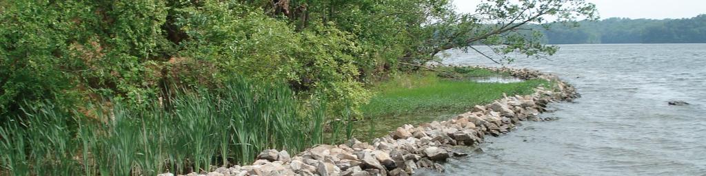
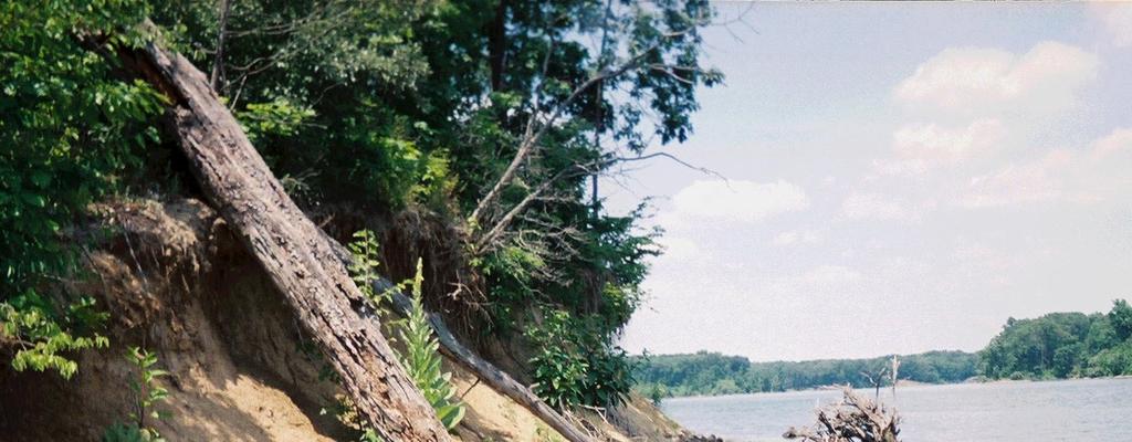
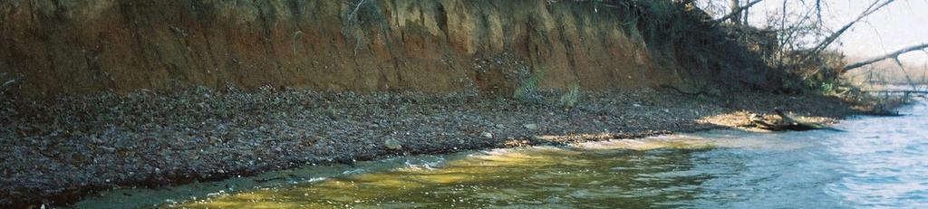
6 Terms of the Typical Eroding Shoreline Limits of wave energy (Zone B ).... Wave energy is confined to Zone B. The soil in Zone B is taken into suspension by wave energy and is transported to deeper water, where it settles to the bottom and remains indefinitely as sediment. Wave energy undermines Zone A and soil falls into Zone B where it too is removed by wave energy. The soil in Zone C is not effected by wave energy. As soil is removed from the bank to deeper water, the bank retreats inland.
7 Shoreline erosion after 2 years Shoreline erosion of an unprotected shoreline
8 Shoreline erosion after 2 years Shoreline erosion after 30 years For Illustration Only
9 original slope original shoreline full pool
10 Under Designed No Filter Fabric Not enough riprap to dissipate the wave energy.


11 Full Pool Low water reveals a failed revetment No Filter Fabric - No Apron

12 No filter fabric & no apron


13 Riprap subsidence without filter fabric The riprap subsides as the underlying soil is removed. Filter Fabric - Isolates the substrate from. wave energy & - Spreads the weight of. the riprap

14 Placing Filter Fabric


15 Pinning Filter Fabric in Place Pin Driver


16 Pontoon boat helps keep fabric spread


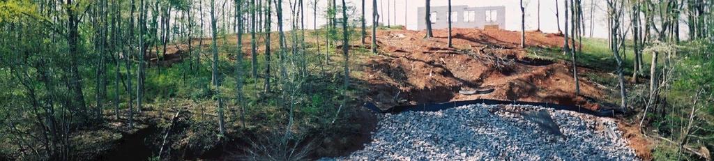
17 Building the apron Free fall of the riprap should be held to a minimum to prevent damaging the fabric


18 Another method of protecting the fabric is to allow the riprap to drop onto the existing rock and then cascade onto the fabric.


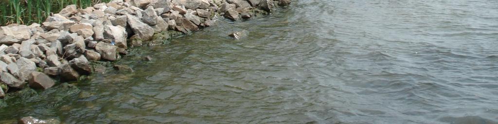
19 Filter fabric not fully spread (bunched-up).


20 Filter fabric too narrow. proposed toe Minimum width required 15 wide rolls work well in most cases.


21 Upper limit of Zone B full pool Riprap subsides as substrate material is lost.


22 Failed due to substrate loss No Filter Fabric


23 effective lean revetment unprotected shoreline
24 The result of substrate loss & riprap subsidence Full pool 40 feet This shoreline has retreated 40 feet since the failure. No Filter Fabric (Water level: 60 below full pool )


25 Failed in less than 10 years Original shoreline 42 below full pool No Filter Fabric Inadequate Toe Protection & Low Quality Riprap

26 apron Low water reveals an effective apron on filter fabric
27 Looks Good.
28 Except
29 The structure is being threatened by underwater substrate loss. No filter fabric and no apron. Filter fabric and a well built apron could have prevented a possible failure at this location
30 ~ 1:1 surface slope under size RR-3 One mile fetch Fabric Exposed Full Pool Surface slope too Steep for the Riprap Size


31 3:1 surface slope under size RR-3 One mile fetch Smaller riprap can be used if the surface slope is reduced.
32 It would not be practical to reduce the surface slope at this location, therefore, larger riprap must be used to provide stability.

33 Under-Designed Surface slope too steep for the riprap size No filter fabric


34 Specify DOT Approved, High Quality Riprap Low quality riprap is broken down by the stresses of freezing & thawing. This 400 pound riprap was reduced to rubble in only 15 years
35 1997
36 1999
37 2002


38 2005 original riprap location original slope Low water reveals a failed riprap revetment Low Quality Riprap & No Filter Fabric


39 Breakwater built by: Macoupin Boats Shoreline naturally colonized. Before


40 Bank sloughing & Natural Healing
41 An example of natural healing
42 An example of natural healing


43 After 5 years After 3 years An example of natural healing


44 1999 Early Spring years of Post Construction Geomorphology Summer Nearing its angle of repose No vegetation yet


45 Accurate Quality Control insures effectiveness without wasting material.
46 Stakes indicate the limit of the apron
47 Monroe City Reservoir Bio-engineered Shoreline Stabilization If the rock toe subsides, the bio-engineered elements will be undermined and are likely to fail. rock toe apron filter fabric To avoid subsidence, the rock toe should be designed and built with: High Quality Stone Filter Fabric & Protective Apron


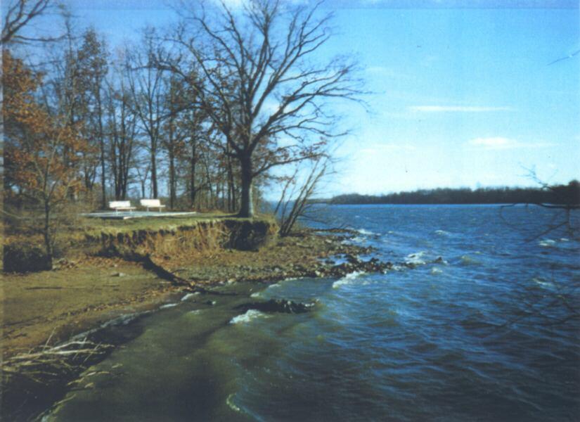
48 Boat Damage Run-away duck blind Physical damage caused geo-tubes to fail. Snow mobile damage Failed geo-tube


49 Repaired Geo-tube Structure with natural plant colonization.
50 No filter fabric & no toe protection With filter fabric and toe protection, sand bags filled with dry concrete mix can be effective.


51 Coconut fiber log with no additional toe protection. Failed in the existing high wave energy at these locations


52 Coconut fiber logs can be successful in lower wave energy.

53 No filter media behind the wall - No toe protection


54 16 lost Full pool Original Bottom No Toe Protection Wave energy is reflected off a bulkhead in all directions - energy reflected horizontally creates intersecting waves - energy reflected up creates a splash - energy reflected down erodes the unprotected substrate


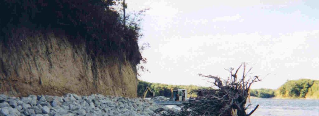
55 The foundation of this sea-wall has been undermined by substrate erosion. Note: Photographed at Low water

56 Failed steel sea-wall. No toe protection Inadequate embedment

57 Soil lost behind the failed sea-wall.
 & 2) Wave Reflection Some Lakes")

58 Riprap toe protection corrects two serious problems: 1) Toe Erosion (Scour) & 2) Wave Reflection Some Lakes require riprap toe protection for all sea-walls. This area was starting to failing when the riprap was installed.
59 The Failure of Over Design - Unnatural appearance - Wasted material - Impedes vegetation. and wildlife access
60 The Failure of Over Design This bank could have healed naturally with a lean revetment.

")
61 With a high, steep bank, Lake Rip Rap usually recommends: 1) In remote areas: Depending on the littoral slope, either an off-shore breakwater or lean riprap revetment followed by natural healing. Lean Riprap Revetment Setting the stage for a natural healing If quicker results are needed: 2) In residential or park areas: Bio-engineered upper bank with a Riprap Toe on Filter Fabric.


62 Shoreline erosion control using conventional equipment can be very destructive. Macoupin Boat working in the Shawnee National Forest with no environmental damage to the wooded slopes..
63 Shoreline Improvement? Or is it For Illustration Only
64 Conclusions: Most Common Causes of Shoreline Failures 1. No Filter Fabric or fabric not properly installed 2. Inadequate toe protection (no apron or toe trench) 3. Under-designed or Over-designed 4. Surface slope too steep for the size of riprap used 5. Low Quality riprap If these 5 problems are avoided, and if the structure is monitored and maintained, it should be affordable & effective for a life time.


65 Why does the west bank erode as fast as the east bank?


66 The east bank of our local reservoirs receive more wave energy than the west bank because of the prevailing wind direction. N Prevailing Wind Lake Shelbyville West Bank East Bank


67 Coffeen Lake Montgomery County, Illinois West Bank East Bank


68 Clinton Lake DeWitt County, Illinois North East Bank South West Bank


69 Late Fall Undisturbed, compact, cohesive soil is fairly resistant to wave energy. Frost heave greatly weakens cohesive soil, increasing its erodibility in the Spring. After the Spring thaw, the weakened soil is quickly removed by very little wave energy. Early Spring Photo Credit: Jack Nawrot

70 Kinkaid Lake, Murphysboro, Illinois Early Spring Photo credit: Jack Nawrot The bank retreat in March alone may be 10 times that of all the other months combined. An annual event. A few weeks later

71 This soil weakened by frost heave was removed within 3 weeks after the Spring Thaw. Gillespie New Lake
72 Other factors to consider Stronger winds in the spring Different Soil Types & Strength (varying mixtures of sand, silt & clay) Depth of frost penetration Soil Moisture Content
73 Is it possible that the existing soil is so extremely weakened by frost heave that: Shoreline erosion is as severe on the west bank as on the east bank, even though the west bank receives less wave energy. Most shoreline erosion and retreat occurs within a month after Spring thaw and Frost Heave may actually effect shoreline erosion as much as prevailing wind direction?
Estuarine Shoreline Stabilization
 Estuarine Shoreline Stabilization Property Owner s Guide to Determining the Most Appropriate Stabilization Method Estuarine shorelines are dynamic features that experience continued erosion. Land is lost
Coastal Change and Conflict
 Coastal Change and Conflict Outline of the Topic Contrasting Coasts why do all coasts not look the same? Geology of the coast the impact rock structure has on the coastline Waves Constructive and destructive
Shoreline Studies Program, Department of Physical Sciences, VIMS
 Living Shoreline Training Class 2017 1 Demonstration sites discussed in this talk. 2 A shoreline management plan for the entire creek made conceptual shoreline management recommendations along every stretch
As temporary grade control facilities along waterways until final stabilization is established.
 Check Dams (CD) EC-12 Description Check dams are temporary grade control structures placed in drainage channels to limit the erosivity of stormwater by reducing flow velocity. Check dams are typically
VIMS CCRM Coastal Management Decision Tools. Decision Tree for Undefended Shorelines and Those with Failed Structures
 VIMS CCRM Coastal Management Decision Tools Decision Tree for Undefended Shorelines and Those with Failed Structures Center for Coastal Resources Management Virginia Institute of Marine Science Gloucester
For more information or permission to reprint slides, please contact Donna Milligan at 1
 For more information or permission to reprint slides, please contact Donna Milligan at milligan@vims.edu 1 For more information or permission to reprint slides, please contact Donna Milligan at milligan@vims.edu
REPORT GEO-TECHNICAL INVESTIGATION FOR THE PROPOSED BLOCK-7 SUB-STATION SY NO-225, NEAR RAYACHERLU VILLAGE
 REPORT ON GEO-TECHNICAL INVESTIGATION FOR THE PROPOSED BLOCK-7 SUB-STATION SY NO-225, NEAR RAYACHERLU VILLAGE CLIENT: KARNATAKA SOLAR POWER DEVELOPMENT CORPORATION BANGALORE 0 GEO-TECHNICAL INVESTIGATION
REPORT GEO-TECHNICAL INVESTIGATION FOR THE PROPOSED BLOCK-1 SUB-STATION SY NO-44, NEAR KYATAGANACHERLU VILLAGE
 REPORT ON GEO-TECHNICAL INVESTIGATION FOR THE PROPOSED BLOCK-1 SUB-STATION SY NO-44, NEAR KYATAGANACHERLU VILLAGE CLIENT: KARNATAKA SOLAR POWER DEVELOPMENT CORPORATION BANGALORE 0 GEO-TECHNICAL INVESTIGATION
Natural Shoreline Restoration for High Energy Shorelines. Brian Majka Restoration Ecologist 3/7/2019
 Natural Shoreline Restoration for High Energy Shorelines Brian Majka Restoration Ecologist 3/7/2019 Today we ll discuss: High energy shorelines Restoration techniques for high energy shorelines Project
(Revised February,2005) CULVERTS, BRIDGES, AND FORDS
 CULVERTS, BRIDGES, AND FORDS") GUIDE TO STREAM CROSSINGS (Revised February,2005) CULVERTS, BRIDGES, AND FORDS Culverts, bridges, and fords are all methods used to cross-streams. Culverts are the most common stream crossing structure.
GUIDE TO STREAM CROSSINGS (Revised February,2005) CULVERTS, BRIDGES, AND FORDS Culverts, bridges, and fords are all methods used to cross-streams. Culverts are the most common stream crossing structure.
Living Shorelines Non-structural Erosion Control Practices Rhode Island Land & Water Summit, 2014
 Living Shorelines Non-structural Erosion Control Practices Rhode Island Land & Water Summit, 2014 D. Steven Brown (1) Kevin Ruddock (1) Rhonda Smith (2) The Nature Conservancy United States Fish and Wildlife
OECS Regional Engineering Workshop September 29 October 3, 2014
 B E A C H E S. M A R I N A S. D E S I G N. C O N S T R U C T I O N. OECS Regional Engineering Workshop September 29 October 3, 2014 Coastal Erosion and Sea Defense: Introduction to Coastal/Marine Structures
CHAPTER 4 - SHORELINE PROTECTION STUDY AND PLAN
 CHAPTER 4 Shoreline Protection Study and Plan 4-1 CHAPTER 4 - SHORELINE PROTECTION STUDY AND PLAN I. SHORELINE PROTECTION STUDY Lancaster County is a coastal community that has, as previously stated, approximately
REVETMENTS. Purposes and Operational Constraints. Purposes Erosion control o o. Revetment Design 4/5/2016. CE A676 Coastal Engineering
 REVETMENTS Ijsseldam, the Netherlands Orson P. Smith, PE, Ph.D. Instructor Purposes and Operational Constraints Purposes Erosion control o o Embankment Toe protection for a seawall, retaining wall or other
4/20/17. #32 - Coastal Erosion Case Histories - Lake Michigan
 Writing Assignment Due Monday by 11:59 pm #32 - Coastal Erosion Case Histories - Lake Michigan See main class web pages for detailed instructions Submit papers Illinois Compass No copying: Compass will
RULES PUBLICATION NO. 52/P UNDERWATER INSPECTION OF MOBILE OFFSHORE DRILLING UNITS IN LIEU OF DRYDOCKING
 RULES PUBLICATION NO. 52/P UNDERWATER INSPECTION OF MOBILE OFFSHORE DRILLING UNITS IN LIEU OF DRYDOCKING 2001 Publications P (Additional Rule Requirements) issued by Polski Rejestr Statków complete or
ALTERNATIVES FOR COASTAL STORM DAMAGE MITIGATION
 ALTERNATIVES FOR COASTAL STORM DAMAGE MITIGATION Dave Basco Old Dominion University, Norfolk, Virginia, USA National Park Service Photo STRUCTURAL (changes to natural, physical system) hardening (seawalls,
NORTHAMPTON COUNTY WETLANDS BOARD Minutes May 15, 2013
 NORTHAMPTON COUNTY WETLANDS BOARD Minutes May 15, 2013 This was the regular meeting of the Northampton County Wetlands Board held on Wednesday, May 15, 2013 in the Board Chambers located at 16404 Courthouse
Chutes Part 2: Synthetic linings
 s Part 2: Synthetic linings DRAINAGE CONTROL TECHNIQUE Low Gradient Velocity Control Short Term Steep Gradient Channel Lining Medium-Long Term Outlet Control [1] Soil Treatment Permanent [2] [1] s can
Define the key terms: - Abrasion - Attrition - Hydraulic action - Solution. Y11 Coasts
 Define the key terms: - Abrasion - Attrition - Hydraulic action - Solution Abrasion caused by waves picking up material which is forced against the cliff face wearing it away Attrition where stones and
Label the diagram below with long fetch and short fetch:
 Coastal Processes Coasts are shaped by the sea and the action of waves. The processes that take place are erosion, transportation and deposition. The power of waves is one of the most significant forces
PRACTICE STANDARDS AND NR 328. Choosing a Technique and Getting a Permit
 PRACTICE STANDARDS AND NR 328 Choosing a Technique and Getting a Permit CHOOSING A TECHNIQUE Define cause of erosion Upland runoff? Impervious areas? Velocities? Wave energies? Boat or wind generated?
July 14, The Beaches Conference Greg Berman (WHOI Sea Grant & Cape Cod Cooperative Extension)
") July 14, 2017 The Beaches Conference 2017 Greg Berman (WHOI Sea Grant & Cape Cod Cooperative Extension) Annual downscaled global tropical cyclones, averaged over the six models. Uses data from IPCC Fifth
July 14, 2017 The Beaches Conference 2017 Greg Berman (WHOI Sea Grant & Cape Cod Cooperative Extension) Annual downscaled global tropical cyclones, averaged over the six models. Uses data from IPCC Fifth
INFILTRATION PRACTICE MAINTENANCE INSPECTION FORM
 Facility Number: Date: Time: Subdivision Name: Watershed: Weather: Inspector(s): Date of Last Rainfall: Amount: Inches Streets: Mapbook Location: GPS Coordinates: Property Classification: Residential 9
ALTERNATIVES FOR COASTAL STORM DAMAGE MITIGATION AND FUNCTIONAL DESIGN OF COASTAL STRUCTURES
 The University of the West Indies Organization of American States PROFESSIONAL DEVELOPMENT PROGRAMME: COASTAL INFRASTRUCTURE DESIGN, CONSTRUCTION AND MAINTENANCE A COURSE IN COASTAL DEFENSE SYSTEMS I CHAPTER
Coasts. 1. Coastal Processes. 1.1 Coastal erosion. 1.2 Sediment transport. Coastal Processes and Landforms. i. Hydraulic action
 Coasts Coastal Processes and Landforms 1. Coastal Processes 1.1 Coastal erosion i. Hydraulic action When waves strike against a rock surface, the waves trap air in the rock joints. This air is compressed
RI Regulatory Setbacks & Buffers: Coastal Management Issues
 RI Regulatory Setbacks & Buffers: Coastal Management Issues New England Onsite Wastewater Training Program @ URI OWT 155 - November 29, 2012 James Boyd - Coastal Policy Analyst Photo: October 30, 2012
Suitable Applications Check dams may be appropriate in the following situations: To promote sedimentation behind the dam.
 Categories EC Erosion Control SE Sediment Control TC Tracking Control WE Wind Erosion Control Non-Stormwater NS Management Control Waste Management and WM Materials Pollution Control Legend: Primary Category
Exemplar for Internal Assessment Resource Geography Level 3. Resource title: The Coastal Environment Kaikoura
 Exemplar for internal assessment resource Geography 3.5A for Achievement Standard 91430 Exemplar for Internal Assessment Resource Geography Level 3 Resource title: The Coastal Environment Kaikoura This
(Refer Slide Time: 1:01)
") Port and Harbour Structures. Professor R. Sundaradivelu. Department of Ocean Engineering. Indian Institute of Technology, Madras. Module-3. Lecture-11. Breakwater. So we have so far discussed 5 lectures,
Port and Harbour Structures. Professor R. Sundaradivelu. Department of Ocean Engineering. Indian Institute of Technology, Madras. Module-3. Lecture-11. Breakwater. So we have so far discussed 5 lectures,
UNDERWATER BRIDGE INSPECTION REPORT STRUCTURE NO CSAH 4 OVER THE BEAVER RIVER ST. LOUIS COUNTY
 UNDERWATER BRIDGE INSPECTION REPORT STRUCTURE NO. 7635 CSAH 4 OVER THE BEAVER RIVER ST. LOUIS COUNTY JUNE 18, 2012 PREPARED FOR THE MINNESOTA DEPARTMENT OF TRANSPORTATION BY COLLINS ENGINEERS, INC. JOB
Photo by: Darryl Hatheway, 2011
 Photo by: Darryl Hatheway, 2011 September 11, 2015 Presentation Discussion Examine PFD V-Zone Mapping in Wave Runup Dominated West Coast Application of PFD V-Zone Mapping Criteria in Pacific G&S PFD V-Zone
COASTAL SYSTEMS WAVE ENERGY
 WAVE ENERGY The energy of a wave determines its ability to erode and transport material on the coast Wave energy depends on the fetch, the distance the wind has blown the wave Wind strength and wind duration
Coastal Processes and Landforms
 Coastal Processes and Landforms These icons indicate that teacher s notes or useful web addresses are available in the Notes Page. This icon indicates that the slide contains activities created in Flash.
OCEANS. Main Ideas. Lesson 2: Ocean Currents Ocean Currents help distribute heat around Earth.
 Oceans Chapter 10 OCEANS Main Ideas Lesson 2: Ocean Currents Ocean Currents help distribute heat around Earth. Lesson 3: The Ocean Shore The shore is shaped by the movement of water and sand. OCEANS SO
GONE! Coastal Erosion Happens During Storms! Why Worry About Coastal Setbacks? Goals for Today
 RI Regulatory Setbacks & Buffers: Coastal Zone Management Issues New England Onsite Wastewater Training Program @ URI OWT 155 November 21, 2013 Goals for Today Understand the impacts of storms, coastal
The Sea Geography Notes JC-Learn. JC-Learn. Geography Notes The Sea. 1 P a g e
 JC-Learn Geography Notes The Sea 1 P a g e The Sea *Here, you can choose to study the chapter on glaciation or the one on the sea, or even both, because whenever these topics come up in the Junior Cert
LAB: WHERE S THE BEACH
 Name: LAB: WHERE S THE BEACH Introduction When you build a sandcastle on the beach, you don't expect it to last forever. You spread out your towel to sunbathe, but you know you can't stay in the same spot
Blakely Island, N Thatcher Bay. Restoration Recommendation: Rank Score (total score)
") Soft Shore Protection/Structure Removal Blueprint for San Juan County Forage Fish Beaches Appendix 2: Recommendations for sites scoring below the top ten, sorted by island (east to west) Blakely Island,
Soft Shore Protection/Structure Removal Blueprint for San Juan County Forage Fish Beaches Appendix 2: Recommendations for sites scoring below the top ten, sorted by island (east to west) Blakely Island,
DUNE STABILIZATION AND BEACH EROSION
 DUNE STABILIZATION AND BEACH EROSION CAPE HATTERAS NATIONAL SEASHORE NORTH CAROLINA ROBERT DOLAN PAUL GODFREY U. S. DEPARTMENT OF INTERIOR NATIONAL PARK SERVICE OFFICE OF NATURAL SCIENCE WASHINGTON, D.
Greg Berman (WHOI Sea Grant & Cape Cod Cooperative Extension) November 2, 2017
 November 2, 2017") November 2, 2017 Are You Ready for the Next Big Storm?: A Workshop for Hardy Cape Codders Greg Berman (WHOI Sea Grant & Cape Cod Cooperative Extension) Outline: ~30 min talk & time for questions Practical
November 2, 2017 Are You Ready for the Next Big Storm?: A Workshop for Hardy Cape Codders Greg Berman (WHOI Sea Grant & Cape Cod Cooperative Extension) Outline: ~30 min talk & time for questions Practical
JAP Additional Information Sheet
 JAP Additional Information Sheet Block 15: Purpose and Need The USACE purpose of the project is to provide a safe and reliable whitewater park for the recreational public in a city park, which will provide
The Dynamic Coast. Right Place Resources. A presentation about the interaction between the dynamic coast and people
 The Dynamic Coast Houses threatened by coastal erosion in California Right Place Resources A presentation about the interaction between the dynamic coast and people For the rest of the presentations in
Building Coastal Resiliency at Plymouth Long Beach
 Building Coastal Resiliency at Plymouth Long Beach Department of Marine and Environmental Affairs March 30, 2017 Introducing Green Infrastructure for Coastal Resiliency Plymouth Long Beach & Warren s Cove
1.5 How do ocean waves and currents change the face of coastal areas? (Chapter 3)
") 1.5 How do ocean waves and currents change the face of coastal areas? (Chapter 3) 1. Hydraulic Action/Pressure - air being forced into crack in rocks. 2. Corrosion (Solution) Minerals such as calcium carbonate
1.5 How do ocean waves and currents change the face of coastal areas? (Chapter 3) 1. Hydraulic Action/Pressure - air being forced into crack in rocks. 2. Corrosion (Solution) Minerals such as calcium carbonate
Earth Science Chapter 16 Section 3 Review
 Name: Class: Date: Earth Science Chapter 16 Section 3 Review Multiple Choice Identify the choice that best completes the statement or answers the question. 1. The movement of water that parallels the shore
Great Lakes Stream Crossing Inventory Instructions
 Great Lakes Stream Crossing Inventory Instructions This document is a guide to completing the Stream Crossing Data Sheet (2/28/11 version). Careful attention to this guidance will ensure consistent crossing
CENGRS GEOTECHNICA PVT. LTD. Job No Sheet No. 1
 CENGRS GEOTECHNICA PVT. LTD. Job No. 214030 Sheet No. 1 INTERIM REPORT ON GEOTECHNICAL INVESTIGATION FOR PROPOSED 66 KV GRID PLOT AT G-7, DWARKA, NEW DELHI. 1.0 INTRODUCTION 1.1 Project Description M/s.
APPENDIX C VEGETATED EMERGENCY SPILLWAY. VERSION 1.0 March 1, 2011
 APPENDIX C VEGETATED EMERGENCY SPILLWAY VERSION 1.0 March 1, 2011 [NOTE: Could use a better photo more clearly showing the emergency spillway in the context of the dam.] SECTION C-1: DESCRIPTION OF PRACTICE
Earthen Embankments. turning into larger, more costly repairs. The following. The State Dam Safety Program has inspection
 TOPIC: COMMON PROBLEMS FOR SMALL DAMS WITH CONCRETE CHANNEL SPILLWAYS The State Dam Safety Program has inspection requirements for state regulated dams. A dam, like any man-made structure, will change
General Coastal Notes + Landforms! 1
 General Coastal Notes + Landforms! 1 Types of Coastlines: Type Description Primary Coast which is essentially in the same condition when sea level stabilized Coastline after the last ice age, younger.
ALTERNATIVE SHORELINE TREATMENT GUIDELINE
 ALTERNATIVE SHORELINE TREATMENT GUIDELINE Prepared By: Galveston Bay Foundation 17324-A Highway 3 Webster, TX 77598 281-332-3381 www.galvbay.org May 9, 2003 17324-A Highway 3, Webster, TX 77598 Phone 281-332-3381
29 National Estuarine Research Reserves
 Estuarine habitat is where it's at! Living Shorelines for Erosion Control Whitney Jenkins North Carolina Coastal Reserve & National Estuarine Research Reserve Division of Coastal Management 29 National
Civil Application Solutions
 Civil Application Solutions Features - Chiseled Cutting Edges - Increased Surface Area - Lateral Direction Guide Ribs Benefits - Faster Installation and Penetrates Harder Soils - Quicker Loading, Stronger
Concepts & Phenomena
 Concepts & Phenomena in coastal and port sedimentation R. Kamalian Ports and Maritime Organization of Iran and PIANC-Iran 7 9 December 2015 What is the problem? Many harbours have sedimentation problems
NORTHAMPTON COUNTY WETLANDS BOARD Minutes December 15, 2010
 NORTHAMPTON COUNTY WETLANDS BOARD Minutes December 15, 2010 This was the regular meeting of the Northampton County Wetlands Board held on Wednesday, December 15, 2010, in the former Northampton Middle
An Update of Coastal Erosion in Puerto Rico
 Jack Morelock and Maritza Barreto An Update of Coastal Erosion in Puerto Rico Department of Marine Sciences, University of Puerto Rico at Mayagüez and Geography Department, University of Puerto Rico at
COASTS (P.38-45) Management: Hard engineering: Groynes Sea walls Gabions Soft Engineering: Beach replenishment Dune regeneration
 Management: Hard engineering: Groynes Sea walls Gabions Soft Engineering: Beach replenishment Dune regeneration") COASTS (P.38-45) Processes: Types of wave Weathering Mass Movement Erosion Transport Deposition Landforms: Cracks Caves Arches Stacks/stumps Headlands/bays Coves Spits Tombolos Beaches Sand dunes Management:
COASTS (P.38-45) Processes: Types of wave Weathering Mass Movement Erosion Transport Deposition Landforms: Cracks Caves Arches Stacks/stumps Headlands/bays Coves Spits Tombolos Beaches Sand dunes Management:
STATUS REPORT FOR THE SUBMERGED REEF BALL TM ARTIFICIAL REEF SUBMERGED BREAKWATER BEACH STABILIZATION PROJECT FOR THE GRAND CAYMAN MARRIOTT HOTEL
 August 23 STATUS REPORT FOR THE SUBMERGED REEF BALL TM ARTIFICIAL REEF SUBMERGED BREAKWATER BEACH STABILIZATION PROJECT FOR THE GRAND CAYMAN MARRIOTT HOTEL performed by Lee E. Harris, Ph.D., P.E. Consulting
Culvert Design for Low and High Gradient Streams in the Midwest. Dale Higgins, Hydrologist Chequamegon-Nicolet National Forest
 Culvert Design for Low and High Gradient Streams in the Midwest Dale Higgins, Hydrologist Chequamegon-Nicolet National Forest Overview Culvert Design Considerations Hydraulic Terms Culvert Impacts Low
1.1 Coastal processes produce landforms
 1.1 Coastal processes produce landforms Types of wave: destructive and constructive Destructive Carry out erosion Tall Powerful High frequency Backwash greater than the swash Take sediment from beach to
Beaches Unit (4.5 pts)
") T. James Noyes, El Camino College Beaches Unit (Topic 6A) page 1 Name: Section: Beaches Unit (4.5 pts) Beaches and Shorelines Are Always Changing Waves are slowly and inexorably altering the shoreline,
T. James Noyes, El Camino College Beaches Unit (Topic 6A) page 1 Name: Section: Beaches Unit (4.5 pts) Beaches and Shorelines Are Always Changing Waves are slowly and inexorably altering the shoreline,
AD-A II~lllII I I 7
 AD-A284 157 II~lllII CONSTRUCTION OF BREAK WATERS AND BEACEFILL AT THE NAVAL AIR STATION, PATUXENT RIVER, MARYLAND C D.W.Yang, J.McWilliams 2, S.Ming 2 ABSTRACT Construction of the breakwaters and beach
Nearshore Sediment Transport What influences the loss of sediment on Beaches? - Waves - Winds - Tidal Currents - River discharge - Runoff
 Tides & Beaches Nearshore Sediment Transport What influences the loss of sediment on Beaches? - Waves - Winds - Tidal Currents - River discharge - Runoff Oceans Ocean Topography Physical Structure of the
Friends of the Detroit River Habitat Restoration Project Update
 Friends of the Detroit River Habitat Restoration Project Update 11 Beneficial Use Impairments (BUIs) were originally identified to be associated with the Detroit River: 1. Restrictions on fish and wildlife
CHAPTER 4: BEST MANAGEMENT PRACTICES FOR EROSION AND SEDIMENTATION CONTROL
 Figure 4.4m. Type III Floating Turbidity Barrier Source: American Boom and Barrier Corporation and Virginia Department of Transportation (DOT) Standard Sheets 71 4.4.6 Floating Turbidity Barrier Definition
LAMINATED POLES. engineered to solve problems. Coastal Douglas-fir. Field Raked and Tangent Poles
 Coastal Douglas-fir Field Raked and Tangent Poles LAMINATED POLES engineered to solve problems 1 Design Criteria Submission Form You can either fax this information to 253-627-4188 or submit your drawings
Cove Point Beach Restoration: Utilization of a Spawning Habitat by Horseshoe Crabs (Limulus polyphemus)
") Cove Point Beach Restoration: Utilization of a Spawning Habitat by Horseshoe Crabs (Limulus polyphemus) Paul Bushmann, Jessica Peterson, Bethany Enyeart and Deborah Smith Anne Arundel Community College
Cove Point Beach Restoration: Utilization of a Spawning Habitat by Horseshoe Crabs (Limulus polyphemus) Paul Bushmann, Jessica Peterson, Bethany Enyeart and Deborah Smith Anne Arundel Community College
Living Shorelines. Created by: JoAnn Moody & Tina Miller-Way Discovery Hall Programs Dauphin Island Sea Lab
 Living Shorelines Created by: JoAnn Moody & Tina Miller-Way Discovery Hall Programs Dauphin Island Sea Lab Living Shorelines Subject: Life Science Grade Level: 6 th -8 th Time Required: 60 min Key Terms:
Soft Designs for a Harsh Climate: Trends in Coastal Engineering
 Alaska Department of Transportation & Public Facilities Ruth Carter, PE, and Harvey Smith, PE Coastal Engineering Section 20 October 2014 Soft Designs for a Harsh Climate: Trends in Coastal Engineering
GLOBAL CORAL REEF ALLIANCE A non-profit organization for protection and sustainable management of coral reefs
 GLOBAL CORAL REEF ALLIANCE A non-profit organization for protection and sustainable management of coral reefs Global Coral Reef Alliance, 37 Pleasant Street, Cambridge, MA 02139, USA Telephone: 617-864-4226
Understanding the Tsunami Wave
 The First Tsunami attack on Sri Lanka Krakatoa Island 27 th August 1883 Understanding the Tsunami Wave Generation Propagation Nearshore Transformation Shoreline Entry Inland Dissipation 1 Generation and
Item 404 Driving Piling
 Item Driving Piling 1. DESCRIPTION Drive piling. 2. EQUIPMENT 2.1. Driving Equipment. Use power hammers for driving piling with specified bearing resistance. Use power hammers that comply with Table 1.
How Much Land Has Been Lost?
 Land and Water Interactions Activity 2 of Two We might wonder exactly how much land is lost with erosion. It is easier to see surface changes than to perceive actual amounts in terms of volume. Analytical
Annex E Bridge Pier Protection Plan
 Annex E Bridge Pier Protection Plan Table E1 Bridge Types and Locations Table E2 Flow Conditions For River Sections Figure E1 Bridge Abutment Protection Figure E2 Bridge Pier Protection Figure E3 Central
INTRODUCTION TO COASTAL ENGINEERING
 The University of the West Indies Organization of American States PROFESSIONAL DEVELOPMENT PROGRAMME: COASTAL INFRASTRUCTURE DESIGN, CONSTRUCTION AND MAINTENANCE A COURSE IN COASTAL DEFENSE SYSTEMS I CHAPTER
1.5 Understand how ocean waves and currents change the face of coastal areas. (Chapter 3)
") 1.5 Understand how ocean waves and currents change the face of coastal areas. (Chapter 3) 1. Hydraulic Action/Pressure - air being forced into crack in rocks. 2. Corrosion (Solution) Minerals such as calcium
1.5 Understand how ocean waves and currents change the face of coastal areas. (Chapter 3) 1. Hydraulic Action/Pressure - air being forced into crack in rocks. 2. Corrosion (Solution) Minerals such as calcium
STRUCTURAL STABILITY ASSESSMENT
 STRUCTURAL STABILITY ASSESSMENT CFR 257.73(d) Fly Ash Reservoir II Cardinal Plant Brilliant, Ohio October, 2016 Prepared for: Cardinal Operating Company Cardinal Plant Brilliant, Ohio Prepared by: Geotechnical
Name: Form: 2.To know the difference between Constructive and Destructive wave # $
 Name: Form: Landforms and landscape processes: COASTS 1. To know what factors affect the strength of waves # $ 2.To know the difference between Constructive and Destructive wave # $ 3. To be able to draw
COASTAL ENVIRONMENTS. 454 lecture 12
 COASTAL ENVIRONMENTS Repeated movement of sediment & water constructs a beach profile reflecting the balance between average daily or seasonal wave forces and resistance of landmass to wave action Coasts
3. Types of foundation
 Foundation Engineering CE 48. Types of foundation & foundation materials Contents Introduction Shallow Foundations Deep Foundations Introduction Why different types of? General types of Introduction Why
Identify one factor which influences wave strength (1 Mark) Factors which affect wave strength
 Factors which affect wave strength") Coasts revision Identify one factor which influences wave strength (1 Mark) Factors which affect wave strength Identify one factor which influences wave strength (1 Mark) Factors which affect wave strength
Coasts revision Identify one factor which influences wave strength (1 Mark) Factors which affect wave strength Identify one factor which influences wave strength (1 Mark) Factors which affect wave strength
1 Shoreline Erosion and Deposition
 CHAPTER 12 1 Shoreline Erosion and Deposition SECTION Agents of Erosion and Deposition BEFORE YOU READ After you read this section, you should be able to answer these questions: What is a shoreline? How
Shoreline Development
 Shoreline Development Erosion Control The evolution of the Chesapeake Bay shoreline has been influenced by residential and commercial development along the tidal shoreline. Commercial shoreline development
Anguilla. Wise practices for coping with. i b bea n Se a
 Wise practices for coping with Anguilla Car i b bea n Se a Department of Fisheries and Marine Resources, Anguilla Department of Physical Planning, Anguilla University of Puerto Rico, Sea Grant College
Briefing Book - Glossary. Accretion due to stream sediment added naturally to the shore Puget Sound, Everett
 Glossary Accretion: Accretion is the process of adding sediments to a beach, whether naturally (material deposited by water or blown in by the wind) or artificially (material placed by humans). Accretion
Energy Attenuation & Hybrid Living Shorelines: A Viable Tool for Coastal Resilience
 Energy & Hybrid Living Shorelines: A Viable Tool for Coastal Resilience Hot Topic Session Delaware Estuary Science & Environmental Summit Balancing Progress & Protection 10 Years of Science in Action January
Water Resources Report RKLD Annual Meeting July 30, 2016
 Water Resources Report RKLD Annual Meeting 2016 July 30, 2016 Topics Hydrology Report Indianford Dam trash rack cleanout performance Experimental Project update Review of PAS project Twin floods- 1 to
RESILIENCE THROUGH RESTORATION
 RESILIENCE THROUGH RESTORATION RECLAMATION DISTRICT NO. 1601 TWITCHELL ISLAND SAN JOAQUIN RIVER SETBACK LEVEE PROJECT TWITCHELL ISLAND BASICS Nearly 12 miles of levee Storm drainage facilities Protects
Annual CCR Landfill Inspection OML Existing Landfill OML Expansion Phase 1
 Annual CCR Landfill Inspection OML Existing Landfill OML Expansion Phase 1 Ottumwa-Midland Landfill Prepared for: Ottumwa-Midland Landfill 15300 130 th Street Ottumwa, Iowa 52501 Prepared by: SCS ENGINEERS
TRENCH AND EXCAVATION COLLAPSE
 TRENCH AND EXCAVATION COLLAPSE A. GENERAL This guideline provides operational guidance at rescue incidents that involve the location, disentanglement and removal of victims from sub-surface trench and
Montserrat. Wise practices for coping with. i b bea n Se a
 Wise practices for coping with Montserrat Car i b bea n Se a Fisheries Division, Montserrat Physical Planning Department, Montserrat University of Puerto Rico, Sea Grant College Program Caribbean Development
Components of a Barrage
 Components of a Barrage Definition The only difference between a weir and a barrage is of gates, that is the flow in barrage is regulated by gates and that in weirs, by its crest height. Barrages are costlier
Hope Mills Lake Recreational Improvement Plan. Lake Advisory Committee
 Hope Mills Lake Recreational Improvement Plan Phase I Phase II Phase III This Phase is the time period prior to impoundment of the Lake. These items must be accomplished prior to the Lake level rising
ROAD OCCUPANCY PERMIT APPLICATION # Damascus Township, 60 Conklin Hill Road, Damascus, PA Tel Fax
 Instructions: For a driveway access permit, fill in sections 1, 2, 3 and 4, and the appropriate drawings and sign. For a Utility access, fill in sections 1, 2, 3 and 5, and figures 1 and 3. Prepare a detailed
Nevis. Wise practices for coping with
 Wise practices for coping with Nevis Caribbean Sea Nevis Historical and Conservation Society Department of Physical Planning, Natural Resources and Environment, Fisheries Division University of Puerto
Sediment Basin 7E-12. Design Manual Chapter 7 - Erosion and Sediment Control 7E - Design Information for ESC Measures BENEFITS.
 7E-12 Design Manual Chapter 7 - Erosion and Sediment Control 7E - Design Information for ESC Measures Sediment Basin BENEFITS Flow Control Erosion Control Sediment Control Runoff Reduction Flow Diversion
Creation of Fish and Wildlife Habitat on the Closed Salmon Harbour Mine in Minto, NB
 Creation of Fish and Wildlife Habitat on the Closed Salmon Harbour Mine in Minto, NB M. Coleman 1, R. Rutherford 2, RA Currie 3 1 NB Power 2 Thaumas Environmental Consultants Ltd 3 RA Currie Ltd. Location
* Appalachian Mountains -the mountain range in the Eastern U.S. which terminates in north-central Alabama
 MR. SAND TEACHER'S MANUAL INTRODUCTION: Although Mr. Sand is a cartoon presentation that is attractive to children (of all ages), the material is technically accurate and quite significant to our understanding
Coastal Management at XXX Beach
 Natural and Human Impacts Coastal Management at XXX Beach Natural Headland Erosion - the small headland closest to the lookout has over time eroded leaving a rock platform along with rubble (see figure