KEYNOTE PRESENTATION FSBPA olsen
|
|
|
- Noreen Randall
- 5 years ago
- Views:
Transcription
1 AMELIA ISAND, FLORIDA BEACH MANAGEMENT PARTNERING AND PERSERVERENCE Erik Olsen, PE associates, inc. KEYNOTE PRESENTATION FSBPA 2009
2 IN ORDER TO ADDRESS SHORE PROTECTION TODAY LOCAL INTERESTS PARTNER WITH: FDEP FPS BB&CS US NAVY Nassau County Port Authority F.I.N.D. USACOE
3 LOCAL INTERESTS ON AMELIA ISLAND City of Fernandina Beach (Sponsor) Nassau County South Amelia Island Shore Stabilization Association Municipal Service Benefit Unit (MSBU)
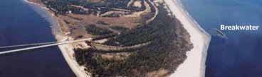
4 YOU ARE HERE REGIONAL SETTING
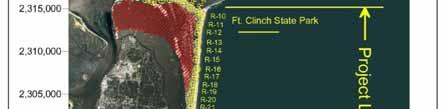
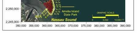
5 Big & Little Talbot Island State Parks (3,600 acres) National Seashore Fort Clinch State Park (1224 acres) Amelia Island State Park (230 acres) PUBLICLY OWNED LANDS
6 Fort Clinch (1998) CONSTRUCTED IN 19 th CENTURY
7 FL et al. GA LIMITS OF NASSAU COUNTY SHOREFRONT
8 FL et al. GA FDEP DESIGNATED CRITICAL EROSION
9 Principal Sources of Long-Term Erosion-Navigation Impacts Stabilization of St. Mary s Entrance (1800 s) Stabilization of St. Johns River (1800 s)


10 St. Mary s Entrance Work began in 1881 N. Jetty (19,300 ft) S. Jetty (11,200 ft) 50 + MCY


11 Amelia Island Nassau Sound Little Talbot Island 1857 Location St. Johns River Entrance
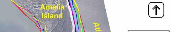

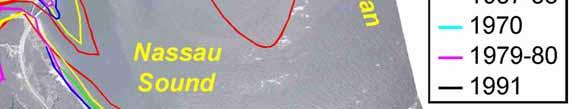


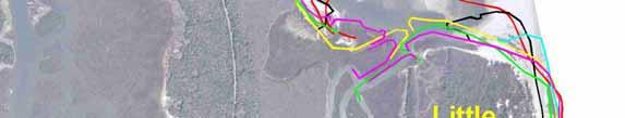

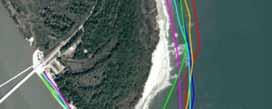
12 Historical Shorelines 2001 Photo Amelia Island State Park


13 Amelia Island Historical Shorelines Atlantic Ocean A.I.S.P. Nassau Sound 2001 Photo
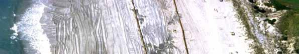
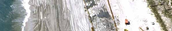
14 Island-wide Pre-Nourishment Historical Erosion Control Solutions Included: Groins (1900 s) Revetments (1965) Geotubes Dune Restoration tio Beach scraping (early 1970 s) Beach disposal


15 Fernandina Beach American Beach Revetments constructed by Federal Government after Hurricane Dora (1964)
16


17 Proactive Shore Stabilization Soln. 1 St. Mary s Entrance Strategic Beach Disposal at N. Amelia Island (1974 Present)
18 St. Mary s Beach Disposal Source Federal Navigation Channel Maintenance Initiated in 1978, mol Has placed over 5 Mcy to date Disposal authorized island-wide: onshore and nearshore e Primary driving-force today is the Kings Bay, GA Naval Submarine Base
19 Memorandum of U.S. Navy / USACOE Understanding (MOU) St. Mary s Entrance Trident Class /St State t of ffl Florida Beach Disposal of all compatible material on Amelia Island No cost to State or Local Gov t Facilitated routinely since 1986 Further codified by Inlet Mgt Plan adopted in 1998
20 Proactive Partnering St. Mary s Entrance Protects Ft. Clinch (first priority) Enhance Fernandina Beach Note: Island-wide disposal is authorized by both MOU and Permit. Principal funding source U.S. Navy


21 Amelia Island Proactive Shore Stabilization Soln. 2 South Amelia Island Beach Restoration Program (Non-Federal)
22
23
24


25
26 The Plan to Save South Amelia Island SAISSA, Inc. formed to address a chronic erosion problem along the South Island shoreline. Nassau County established the SAISS-MSBU to fund a project 1994 a 2.6Mcy, 18,000ft long beach restoration project was constructed. All funding was local. l


27


28
29 First Renourishment In 2002, SAISSA and the Florida Park Service partnered to include the AISP in the first scheduled maintenance of the beach restoration project and to construct several stabilizing structures beneficial to both the Park and the renourishment project. This allowed for some State cost sharing.


30 Damage to AISP Maritime Forest High Tide TUBE High Tide
31 Amelia Island State Park


32 South Amelia Island Beach Restoration A.I.S.P SAISSA Project: 1.76 Mm 3 R-60 to R-78 (5,600 m) Designed and permitted in 18 months 2002 JOINT Project: 16Mm R-60 to R Photo A.I.S.P. Amelia Island State Park
33 Phase II Stabilization To introduce structural stabilization in order to reduce end losses from a 5.6 km (3.5 miles) updrift beach restoration project Nassau Sound Amelia Island A.I.S.P. Atlantic Ocean Beach Fill Phase I (2002) 2001 Photo
34 Phase II Stabilization to recapture State Park acreage lost to erosion Nassau Sound Amelia Island A.I.S.P. Atlantic Ocean Beach Fill Phase I (2002) 2001 Photo


35 Project Goal without adversely affecting the balance of sediment transport required to maintain the downdrift inlet facing shoreline of the state park. Nassau Sound Amelia Island AISP A.I.S.P. Atlantic Ocean 2001 Photo Terminal Structure?
36 Phase II Stabilization Design Precepts Reduce end losses from the beach fill project, Recapture eroded State Park lands, Protect endangered unique maritime forest, and Re-establish establish endangered species habitat.
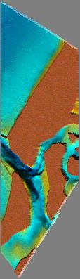
37 Regional Environmental Protection Requirements* No impact to downdrift (inlet facing) shoreline * By Permit


38 Atlantic Ocean Nassau Sound
39 Regional Environmental Protection Requirements* No impact to downdrift (inlet facing) shoreline, No impact to Nassau Sound sediment budget, * By Permit
40 Regional Environmental Protection Requirements* No impact to downdrift (inlet facing) shoreline, No impact to Nassau Sound sediment budget, No impact to Bird Island Shoal Complex. * By Permit
41 Amelia Island Bird Island Shoals
42 Alternative Solutions A.) Beach fill alone not acceptable, B.) Radial Groin Field(s), C.) Terminal structure(s), D.) Breakwater(s),
43 Selected Plan 465 meter long leaky terminal structure, 93 meter long detached breakwater, Strategic updrift placement of advance beach fill to maximize impoundment effects.
44 Hinge Point A.I.S.P. Detached breakwater Concept 6 Leaky Terminal Structure Nassau Sound Atlantic Ocean Little Talbot Island 2001
45 Concept Plan (Pre-Beach Fill) Amelia Island State Park Privately Owned Lands Potential Acreage to be Recaptured 2001 Photo
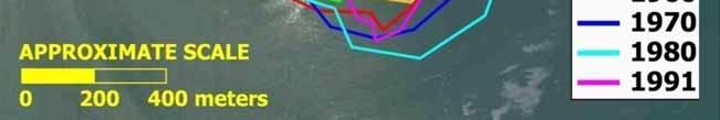
46 2,253,000 R AP ,252,000 MHW (+3.2) 0.0 MLW (-2.1) R-75 Atlantic Ocean Predicted Pl f Planform AP-23 2,251,000 R-76 South Amelia Island November 2002 Northing (ft, NAD2 27) 2,250,000 R-82 Salient at Hinge Point AP-25 R-77 R R-81 2,249,000 Impounded Sh Shoreline li R-78 9 R-80 R-79.5 R R ,248, ,247,000 Spit 2,246,000 GRAPHIC SCALE Nassau Sound 359, , , , ,000 Easting (ft, NAD27) 364, ,000 FT 365,000
47 Anticipated Shoreline Response without Detached Breakwater AISP Anticipated Shoreline Response Existing Terminal Groin Detached Breakwater
48 Anticipated Shoreline Response without Detached Breakwater & with Groin Extension Existing Terminal Groin AISP 1,600 FT Anticipated Shoreline Response 750± ft Detached Breakwater
49 Sept. 2004


50 Evolving Spit Oct Permeable and Low Low Leaky Terminal Structure


51 * Hinge Point Salient Updrift detached breakwater (93 m) required to resolve historical hinge point in shoreline configuration. Low Tide Condition

52 COMPARISON July 2005


53 Breakwater Leaky Groin (buried) Spit Formation HISTORICAL SHORELINES August 2006
54 Amelia Island Proactive Shore Stabilization Soln. 3 Nassau County Shore Protection Project (Fernandina Beach)
")


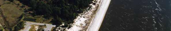
55 (National Seashore) Shore Protection Project Location - State Park


56 Nassau County Shore Protection ti Project Federally Authorized Contractor Weeks Marine Constructed July to Sept, M cubic yards $15 million; mol
57 City of Fernandina Beach The Poster-Child of Perserverence 1946 Beach Erosion Board Study 1960 Study by Sav. District, C.O.E Recon Study by Jax C.O.E. * 1977 Feasibility Study by Jax C.O.E. (with Favorable Section Findings) 1984 Feasibility Study w/ E.I.S GRR (Revised 2004 & 2006) 2008 Construction at 62 YEARS LATER! * 9 years after Hurricane Dora (1964)


58 Cumberland Island Amelia Island St. Marys Entrance The Nassau County Shore Protection Project is one of a Relatively Small Number of Projects Nationally with a Section Component
59
60 Section Mitigation First 50% of Project 100% Federal Second 50% of Project 58% Federal Result Total Federal Cost Average is 79%


61 Project completed in early Oct by Jacksonville District, USACOE
62 Amelia Island Proactive Shore Stabilization Soln. 4 Strategic Beach Disposal North Amelia Island St. Mary s Entrance Navigation Project South Amelia Island Atlantic Intracoastal Waterway (AIWW) Sponsor F.I.N.D.
63 AIWW Dredging Amelia Island Atlantic Ocean Nassau Sound AISP A.I.S.P. Oceanfront Beach Disposal Site 2001 Photo
64 THE END As it could have been
65 THE END As it is
66 QUESTIONS?
Protecting our Beaches
 Protecting our Beaches South Amelia Island Shore Stabilization Project Nassau County, FL Mr. Drew Wallace President South Amelia Island Shore Stabilization Association (SAISSA) Mr. Bill Moore, AICP Project
Beach Renourishment in Jacksonville
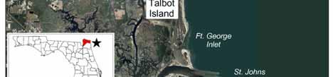
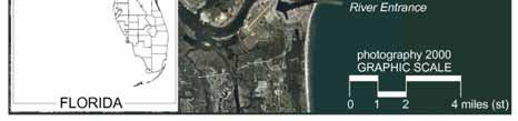
 Beach Renourishment in Jacksonville Kevin Bodge, PhD, P.E. - Olsen Associates, Inc. 1978 Oct 2004 2000 2016 2011 Oct 2016 Coastal Duval County, FL Nassau Sound Blount Island Ft. George Inlet St. Johns
Long Term Success and Future Approach of the Captiva and Sanibel Islands Beach Renourishment Program
 2017 National Conference on Beach Preservation Technology February 8-10, 2017; Stuart, Florida Long Term Success and Future Approach of the Captiva and Sanibel Islands Beach Renourishment Program Thomas
FINAL ENVIRONMENTAL IMPACT STATEMENT ON BROWARD COUNTY SHORE PROTECTION PROJECT SEGMENTS II AND III BROWARD COUNTY, FLORIDA
 FINAL ENVIRONMENTAL IMPACT STATEMENT ON BROWARD COUNTY SHORE PROTECTION PROJECT SEGMENTS II AND III BROWARD COUNTY, FLORIDA 1. PROJECT PURPOSE AND NEED 1.1. PROJECT AUTHORITY. 1.1.1. INITIAL AUTHORIZATION.
Regular Workshop October 20, 2014 Agenda Item: Dr. Albert E. Browder, PE; Olsen Associates, Inc.
 Regular Workshop October 20, 2014 Agenda Item 8 Agenda Item: Presenter: Summary: Beach Update Town Manager; Dr. Albert E. Browder, PE; Olsen Associates, Inc. At the January 21, 2014 Regular Workshop Meeting,
EVALUATION OF BEACH EROSION UP-DRIFT OF TIDAL INLETS IN SOUTHWEST AND CENTRAL FLORIDA, USA. Mohamed A. Dabees 1 and Brett D.
 EVALUATION OF BEACH EROSION UP-DRIFT OF TIDAL INLETS IN SOUTHWEST AND CENTRAL FLORIDA, USA Mohamed A. Dabees 1 and Brett D. Moore 1 The paper discusses the analysis of up-drift beach erosion near selected
MOREHEAD CITY HARBOR, NC. Dredged Material Management Plan (DMMP)
") MOREHEAD CITY HARBOR, NC Dredged Material Management Plan (DMMP) Public Meeting/Info Session 15 January 2014 US Army Corps of Engineers Morehead City Harbor DMMP Presentation Topics Morehead City Harbor
MOREHEAD CITY HARBOR, NC Dredged Material Management Plan (DMMP) Public Meeting/Info Session 15 January 2014 US Army Corps of Engineers Morehead City Harbor DMMP Presentation Topics Morehead City Harbor
BALD HEAD ISLAND, NC SAND SHARING SYSTEM OVERVIEW AND ASSESSMENT. Erik J. Olsen, P.E. olsen associates, inc.
 BALD HEAD ISLAND, NC SAND SHARING SYSTEM OVERVIEW AND ASSESSMENT Erik J. Olsen, P.E. Olsen Associates, Inc. BACKGROUND Both the Village of Bald Head Island (VBHI) and the Bald Head Island Limited, LLC.
CHAPTER 281 INFLUENCE OF NEARSHORE HARDBOTTOM ON REGIONAL SEDIMENT TRANSPORT
 CHAPTER 281 INFLUENCE OF NEARSHORE HARDBOTTOM ON REGIONAL SEDIMENT TRANSPORT Paul C.-P. Lin, Ph.D., P.E. 1 and R. Harvey Sasso, P.E. 2 ABSTRACT The influence of nearshore hardbottom on longshore and cross-shore
Absecon Island Shore Protection The planning behind the project
 Absecon Island Shore Protection The planning behind the project Most residents of Atlantic City, Ventnor, Margate and Longport are now aware of upcoming plans to protect their common coastline with a beachfill
ST. LUCIE COUNTY, FLORIDA
 ST. LUCIE COUNTY, FLORIDA COASTAL STORM RISK MANAGEMENT STUDY Draft Feasibility Study & Integrated Environmental Assessment Public Meeting Presented by U.S. Army Corps of Engineers Jacksonville District
Beach Nourishment Impact on Beach Safety and Surfing in the North Reach of Brevard County, Florida
 Beach Nourishment Impact on Beach Safety and Surfing in the North Reach of Brevard County, Florida Prepared by John Hearin, Ph.D. Coastal Engineering Vice Chairman Cocoa Beach Chapter Port Canaveral Patrick
SACO RIVER AND CAMP ELLIS BEACH SACO, MAINE SECTION 111 SHORE DAMAGE MITIGATION PROJECT APPENDIX F ECONOMIC ASSESSMENT
 SACO RIVER AND CAMP ELLIS BEACH SACO, MAINE SECTION 111 SHORE DAMAGE MITIGATION PROJECT APPENDIX F ECONOMIC ASSESSMENT Department of the Army New England District, Corps of Engineers 696 Virginia Road
Appendix A. Committee Lists
 Appendix A Committee Lists THIS PAGE INTENTIONALLY LEFT BLANK Terminal Groin Study CRC/CRAC Subcommittee Members: o Bob Emory o Jim Leutze o Melvin Shepard o Veronica Carter o Charles Boots Elam o Dara
SHORE PROTECTION AND HABITAT CREATION AT SHAMROCK ISLAND, TEXAS ABSTRACT
 SHORE PROTECTION AND HABITAT CREATION AT SHAMROCK ISLAND, TEXAS M. Cameron Perry, P.E., and Daniel J. Heilman, P.E. Coastal Engineer Shiner Moseley & Associates., Inc. 555 N. Carancahua Corpus Christi,
OECS Regional Engineering Workshop September 29 October 3, 2014
 B E A C H E S. M A R I N A S. D E S I G N. C O N S T R U C T I O N. OECS Regional Engineering Workshop September 29 October 3, 2014 Coastal Erosion and Sea Defense: Introduction to Coastal/Marine Structures
STORM RESPONSE SIMULATION
 APPENDIX V STORM RESPONSE SIMULATION Final Environmental Impact Statement Village of Bald Head Island Shoreline Protection Project Brunswick County, North Carolina Delft3D Storm Response Simulations With
US Beach Nourishment Experience:
 Beach Nourishment: Introduction of new sand to the beach by truck or dredge Large beach >1 million cubic yards (100,000 dump truck loads) Funding is a combination of federal, state, local & private Also
The purpose and needs of the Figure Eight Island Inlet and Shoreline Management Project are as follows:
 Chapter 2 PURPOSE AND NEEDS 1. What are the purpose and needs of this project? The main concern of residents and owners at Figure Eight Island are economic losses resulting from damages to structures and
South Amelia Island Shore Stabilization Project- Beach Renourishment
 South Amelia Island Shore Stabilization Project- Beach Renourishment Evaluation of Beach Nourishment Impacts to Beach Indicator Species Spring 2013 Year 2 Post-Construction Final Report USACE Permit No.
RE: Hurricane Matthew Beach Damage Assessment and Recommendations [CSE 2416]
![RE: Hurricane Matthew Beach Damage Assessment and Recommendations [CSE 2416]](/thumbs/83/87675702.jpg "RE: Hurricane Matthew Beach Damage Assessment and Recommendations [CSE 2416]") October 25, 2016 Iris Hill Town Administrator Town of Edisto Beach 2414 Murray St Edisto Beach SC 29438 RE: Hurricane Matthew Beach Damage Assessment and Recommendations [CSE 2416] Dear Iris, Hurricane
October 25, 2016 Iris Hill Town Administrator Town of Edisto Beach 2414 Murray St Edisto Beach SC 29438 RE: Hurricane Matthew Beach Damage Assessment and Recommendations [CSE 2416] Dear Iris, Hurricane
Beach Restoration in Okaloosa and Walton Counties. FSBPA Technology Conference Clearwater, FL
 Beach Restoration in Okaloosa and Walton Counties FSBPA Technology Conference Clearwater, FL Presented by: Duncan Greer, E.I. February 5, 2015 PRESENTATION OUTLINE 1. Overview of Project Locations 2. Eglin
Inlet Management Study for Pass-A-Grille and Bunces Pass, Pinellas County, Florida
 Inlet Management Study for Pass-A-Grille and Bunces Pass, Pinellas County, Florida Final Report Submitted By Ping Wang, Ph.D., Jun Cheng Ph.D., Zachary Westfall, and Mathieu Vallee Coastal Research Laboratory
Figure79. Location map for the 10 NJBPN profile sites in Atlantic County, NJ 155
 154 Figure79. Location map for the 10 NJBPN profile sites in Atlantic County, NJ 155 ATLANTIC COUNTY SPRING 2009 to FALL 2010 The Atlantic County coastline consists of three barrier islands. Between Little
FEASIBILITY OF SAND BYPASSING SYSTEMS
 MISCELLANEOUS PAPER HL-88-9 FEASIBILITY OF SAND BYPASSING SYSTEMS Of " EngFOR REDUCING MAINTENANCE DREDGING IN THE ST. MARYS RIVER ENTRANCE CHANNEL by David R. Richards ji NHydraulics tand Laboratory James
GenCade Applications Ashley Frey
 GenCade Applications Ashley Frey Research Civil Engineer, Co-PI of the Inlet Engineering Toolbox work unit of CIRP Report Documentation Page Form Approved OMB No. 0704-0188 Public reporting burden for
North Shore of Long Island, Feasibility Study
 North Shore of Long Island, Asharoken New York Asharoken, Feasibility Study Asharoken, NY Public Meeting June 30, 2015 US Army Corps of Engineers US Army Corps of Engineers New York BUILDING STRONG BUILDING
23- Year Sand Volume Changes at Site 132, 15th Street, Brigantine
 149 Figure75. Location map for the 9 NJBPN profile sites in Atlantic County, NJ ATLANTIC COUNTY SPRING 2008 to FALL 2009 150 The Atlantic County oceanfront shoreline consists of three barrier islands.
2018 Beach Preservation Project Information
 QUICK FACTS Beach Renourishment to begin late April 2018 o U.S. Army Corps of Engineers project o Project Area: 8 th St. E. to end of E. Ashley Ave. o Project Length: 2 miles o Cost: $10,900,000 o Funding:
Salt Ponds Shore Zone Modeling for Breakwater Placement: Summary Report
 Salt Ponds Shore Zone Modeling for Breakwater Placement: Summary Report Virginia Institute of Marine Science May 2014 Salt Ponds Shore Zone Modeling for Breakwater Placement: Summary Report For Waterway
2018 Annual Beach Monitoring Report
 May 1, 218 Town of Hilton Head Island, SC 218 Annual Beach Monitoring Report Submitted to: Town of Hilton Head Island, SC November 15, 217 Prepared by: Olsen Associates, Inc. 2618 Herschel Street Jacksonville,
North Carolina s Terminal Groins at Oregon Inlet and Fort Macon Descriptions and Discussions
 Attachment 2 North Carolina s Terminal Groins at Oregon Inlet and Fort Macon Descriptions and Discussions Oregon Inlet Terminal Groin Introduction/Background Oregon Inlet was created by a hurricane on
Atlantic Coast of Long Island, Jones Inlet to East Rockaway Inlet, Long Beach Island, NY Construction Update
 Atlantic Coast of Long Island, Jones Inlet to East Rockaway Inlet, Long Beach Island, NY Construction Update June 2016 US Army Corps of Engineers Project Purpose Three specific damage mechanisms of coastal
NORTHERN CELL OPTIONS SHORTLIST RECOMMENDATIONS
 OPTIONS SHORTLIST RECOMMENDATIONS Coastal Unit C: Bayview Options recommended for MCDA scoring. Status quo. Planting 3. Renourishment (gravel) 6. Beach-scraping 7. Restore shingle crest. Inundation accommodation
Tanya M. Beck. Kelly Legault. Research Physical Scientist Coastal & Hydraulics Lab, ERDC Vicksburg, MS
 Inlet And Adjacent Shoreline Processes at Cascading Time Scales Using the Coastal Modeling System and GenCade Tanya M. Beck Research Physical Scientist Coastal & Hydraulics Lab, ERDC Vicksburg, MS Kelly
Regional Sediment Management Opportunities within Intracoastal Waterway (IWW) Dredging Program in the State of Florida
 Dredging Program in the State of Florida") Regional Sediment Management Opportunities within Intracoastal Waterway (IWW) Dredging Program in the State of Florida INTRODUCTION: The topic of this Regional Sediment Management (RSM) Technical Note
Regional Sediment Management Opportunities within Intracoastal Waterway (IWW) Dredging Program in the State of Florida INTRODUCTION: The topic of this Regional Sediment Management (RSM) Technical Note
Gly 558. Introduction to Coastal Management. Aeolian Processes and Dunes. Namib Coastal Desert. What Can Dunes Tell Us About the Coastal System?
 Gly 558 Introduction to Coastal Management 300m high Namib Coastal Desert GE Crescent dunes Onshore prevailing wind Benguella Current Aeolian Processes and Dunes Linear dunes Fog What Can Dunes Tell Us
3.0 PROJECT ALTERNATIVES
 3.0 PROJECT ALTERNATIVES The National Environmental Policy Act and the CEQ regulations for implementing the NEPA (40 CFR 1500 et. seq.) require the identification and evaluation of reasonable alternatives
Follets Island Nearshore Beach Nourishment Project
 Coast & Harbor Engineering A division of Hatch Mott MacDonald Follets Island Nearshore Beach Nourishment Project Arpit Agarwal, P.E. April 1, 2016 Project Site!"#$% &'(% &)*+% )#,'-+% Shoreline Erosion
Tracy E. Skrabal. October 2, 2012
 Tracy E. Skrabal October 2, 2012 Jurisdiction Living Shorelines/Sills Timeline for Permit Bulkhead/Revetments North Atlantic Division New England Division suspended all nationwide permits March 20, 2012
ATLANTIC COAST OF LONG ISLAND, JONES INLET TO EAST ROCKAWAY INLET, LONG BEACH ISLAND, NY. Contract #2 Construction Scope. April 18th-19th 2018
 ATLANTIC COAST OF LONG ISLAND, JONES INLET TO EAST ROCKAWAY INLET, LONG BEACH ISLAND, NY Contract #2 Construction Scope April 18th-19th 2018 New York District PLAN COMPONENTS Length of Beachfill 35,000
STATUS REPORT FOR THE SUBMERGED REEF BALL TM ARTIFICIAL REEF SUBMERGED BREAKWATER BEACH STABILIZATION PROJECT FOR THE GRAND CAYMAN MARRIOTT HOTEL
 August 23 STATUS REPORT FOR THE SUBMERGED REEF BALL TM ARTIFICIAL REEF SUBMERGED BREAKWATER BEACH STABILIZATION PROJECT FOR THE GRAND CAYMAN MARRIOTT HOTEL performed by Lee E. Harris, Ph.D., P.E. Consulting
Assateague Island National Seashore North End Restoration Project Timeline
 Assateague Island National Seashore North End Restoration Project Timeline Date Event Some information provided in the Project Introduction document. Detailed events are available in a timeline compiled
Saco River Maintenance Dredge PROJECT PLAN AND TIMELINE JUNE 15, 2017
 Saco River Maintenance Dredge 2017-2018 PROJECT PLAN AND TIMELINE JUNE 15, 2017 Overview Last dredged in 1994 Removing ~150,000 cy of sand and silt from the upper and lower reaches Disposal sites: In-River
ATLANTIC COUNTY 2006 to 2008
 ATLANTIC COUNTY 2006 to 2008 The Atlantic County oceanfront shoreline consists of three barrier islands where the northern one, Little Beach Island and a third of the second, Brigantine Island, are undeveloped
APPENDIX M DREDGED MATERIAL MANAGEMENT PLAN (DMMP) FINAL INTEGRATED FEASIBILITY REPORT AND ENVIRONMENTAL ASSESSMENT
 FINAL INTEGRATED FEASIBILITY REPORT AND ENVIRONMENTAL ASSESSMENT") APPENDIX M DREDGED MATERIAL MANAGEMENT PLAN (DMMP) Brazos Island Harbor, Texas Channel Improvement Study FINAL INTEGRATED FEASIBILITY REPORT AND ENVIRONMENTAL ASSESSMENT This page is intentionally left
APPENDIX M DREDGED MATERIAL MANAGEMENT PLAN (DMMP) Brazos Island Harbor, Texas Channel Improvement Study FINAL INTEGRATED FEASIBILITY REPORT AND ENVIRONMENTAL ASSESSMENT This page is intentionally left
A REVIEW OF THE CONDITION OF THE MUNICIPAL BEACHES AS A RESULT OF HURRICANE SANDY IN THE BOROUGH OF STONE HARBOR, CAPE MAY COUNTY, NEW JERSEY
 A REVIEW OF THE CONDITION OF THE MUNICIPAL BEACHES AS A RESULT OF HURRICANE SANDY IN THE BOROUGH OF STONE HARBOR, CAPE MAY COUNTY, NEW JERSEY View along the dune scarp from 103 rd Street on October 31,
4/20/17. #32 - Coastal Erosion Case Histories - Lake Michigan
 Writing Assignment Due Monday by 11:59 pm #32 - Coastal Erosion Case Histories - Lake Michigan See main class web pages for detailed instructions Submit papers Illinois Compass No copying: Compass will
Climate Change Impacts to KSC Launch Complex
 Climate Change Impacts to KSC Launch Complex Presented to: 2010 International Workshop on Environment and Energy By: John Shaffer NASA Environmental Management Branch Kennedy Space Center Hurricane Season
Intracoastal Waterway and other Federal Shallow Draft Inlets
 Intracoastal Waterway and other Federal Shallow Draft Inlets Shelley Trulock Project Manager 904-232-3292 Navigation 900 miles of Inland Waterways 6 navigation locks Atlantic Intracoastal Waterway (AIWW)
Building Coastal Resiliency at Plymouth Long Beach
 Building Coastal Resiliency at Plymouth Long Beach Department of Marine and Environmental Affairs March 30, 2017 Introducing Green Infrastructure for Coastal Resiliency Plymouth Long Beach & Warren s Cove
New Jersey Coastal Zone Overview. The New Jersey Beach Profile Network (NJBPN) 3 Dimensional Assessments. Quantifying Shoreline Migration
 3 Dimensional Assessments. Quantifying Shoreline Migration") New Jersey Coastal Zone Overview The New Jersey Beach Profile Network (NJBPN) Objectives Profile Locations Data Collection Analyzing NJBPN Data Examples 3 Dimensional Assessments Methodology Examples Quantifying
New Jersey Coastal Zone Overview The New Jersey Beach Profile Network (NJBPN) Objectives Profile Locations Data Collection Analyzing NJBPN Data Examples 3 Dimensional Assessments Methodology Examples Quantifying
Coastal Hazards and Management in North Carolina. Braxton Davis April 14, 2015
 Coastal Hazards and Management in North Carolina Braxton Davis April 14, 2015 Coastal Facts and Figures 320 miles of ocean beaches 12,000+ miles of estuarine shoreline 2 million + acres of sounds, creeks,
ALTERNATIVES FOR COASTAL STORM DAMAGE MITIGATION
 ALTERNATIVES FOR COASTAL STORM DAMAGE MITIGATION Dave Basco Old Dominion University, Norfolk, Virginia, USA National Park Service Photo STRUCTURAL (changes to natural, physical system) hardening (seawalls,
PLANNING AND CONSTRUCTION OF SHORE PROTECTION AT SHAMROCK ISLAND, TEXAS: PROJECT UPDATE ABSTRACT
 PLANNING AND CONSTRUCTION OF SHORE PROTECTION AT SHAMROCK ISLAND, TEXAS: PROJECT UPDATE M. Cameron Perry, P.E. and Daniel J. Heilman, P.E. Coastal Engineer HDR Shiner Moseley & Associates., Inc. 555 N.
Poorly located construction seaward
 Implementation of Geotextile T-Groins in Pinellas County, Florida By Nicole A. Elko, Ph.D. Pinellas County Department of Environmental Management 512 S. Fort Harrison Avenue, Clearwater, FL 33756 nelko@pinellascounty.org
Dredged Material Management Plan Atlantic Intracoastal Waterway Port Royal Sound, South Carolina to Cumberland Sound, Georgia November 2015
 Dredged Material Management Plan Atlantic Intracoastal Waterway Port Royal Sound, South Carolina to Cumberland Sound, Georgia November 2015 Appendix B: Biological Assessment of Threatened and Endangered
Controlling Coastal erosion
 Controlling Coastal erosion Coastal Erosion Rates in the U.S. Coastal Erosion and Stabilization Economic pressures demanding the stabilization of beaches and coastlines are immense Coastal Erosion and
6/19/2006 The Reef Ball Foundation 1
 6/19/2006 The Reef Ball Foundation 1 Overview Reef Balls are prefabricated concrete modules used as a base for natural coral reefs to form. Reef Balls have been used in 55 countries in over 3,500 projects
(Sent via Electronic Mail)
") April 1, 2015 F/SER47:JD/pw (Sent via Electronic Mail) Lt. Col. John Litz, Commander Charleston District, Corps of Engineers 69A Hagood Avenue Charleston, South Carolina 29403-5107 Attention: Debra King
April 1, 2015 F/SER47:JD/pw (Sent via Electronic Mail) Lt. Col. John Litz, Commander Charleston District, Corps of Engineers 69A Hagood Avenue Charleston, South Carolina 29403-5107 Attention: Debra King
Impact of Hurricane Matthew on the Atlantic Coast of Florida
 Impact of Hurricane Matthew on the Atlantic Coast of Florida A coastal engineer was driving across country and his jeep broke down in front of a monastery. It was late in the day and the monks invited
FINDING OF NO SIGNIFICANT IMPACT
 DEPARTMENT OF THE ARMY CHARLESTON DISTRICT, CORPS OF ENGINEERS 69A HAGOOD AVENUE CHARLESTON, SOUTH CAROLINA 29403-5107 FINDING OF NO SIGNIFICANT IMPACT EDISTO BEACH COASTAL STORM DAMAGE REDUCTION GENERAL
ALTERNATIVES FOR COASTAL STORM DAMAGE MITIGATION AND FUNCTIONAL DESIGN OF COASTAL STRUCTURES
 The University of the West Indies Organization of American States PROFESSIONAL DEVELOPMENT PROGRAMME: COASTAL INFRASTRUCTURE DESIGN, CONSTRUCTION AND MAINTENANCE A COURSE IN COASTAL DEFENSE SYSTEMS I CHAPTER
Town of Duck, North Carolina
 Tracking No. 00.00.2010 Erosion Mitigation And Shoreline Management Feasibility Study Town of Duck, North Carolina Coastal Planning & Engineering of North Carolina August 15, 2012 Tom Jarrett Robert Neal
Advanced Series on Ocean Engineering - Volume 14 COASTAL STABILIZATION. Richard Silvester John R C Hsu. \v? World Scientific
 Advanced Series on Ocean Engineering - Volume 14 COASTAL STABILIZATION Richard Silvester John R C Hsu \v? World Scientific Contents PREFACE xv 1 INTRODUCTION 1 /. / Coastal Environment 2 J.2 State of Beach
Figure 106. Locations of the 28 NJBPN profile stations in Ocean County, NJ.
 130 Figure 106. Locations of the 28 NJBPN profile stations in Ocean County, NJ. 131 2016-2017 Beach Fills in Ocean County: The federal/state/local storm damage reduction project (beachfill) between Manasquan
United States Department of the Interior
 United States Department of the Interior John Kennelly, Chief Planning Branch Department of the Army New England District U.S. Army Corps of Engineers 696 Virginia Rd Concord, Massachusetts 01742 FISH
ST. JOSEPH PENINSULA, GULF COUNTY, FLORIDA Beach Re-Nourishment and Environmental Enhancement Project RECOMMENDATIONS
 ST. JOSEPH PENINSULA, GULF COUNTY, FLORIDA Beach Re-Nourishment and Environmental Enhancement Project RECOMMENDATIONS January 23, 2018 543 Harbor Boulevard, Suite 204 Destin, Florida 32541 850.654.1555
Impacts of breakwaters and training walls
 Across the eastern seaboard of Australia, breakwaters and training walls have instigated fundamental perturbations to coastal and estuary processes. This has induced long-term changes to foreshore alignments,
2013 FEDERAL STORM RESPONSE
 2013 FEDERAL STORM Presented to the Florida Shore & Beach Association Sep 26, 2013 Presented by: COL Alan Dodd Commander, Jacksonville District September 2013 THE COLLABORATION 2 THE PROGRAM 3 THE STORMS
Louisiana CPRA SJB Group, Baton Rouge Coastal Engineering Consultants U.S. Army Corps of Engineers Federal and State PDT Members
 Louisiana CPRA SJB Group, Baton Rouge Coastal Engineering Consultants U.S. Army Corps of Engineers Federal and State PDT Members Project Setting and Background Island Restoration Plans Pre-Screening Analysis
Mouth of the Columbia River Jetties Three-Phase Construction Plan
 Mouth of the Columbia River Jetties Three-Phase Construction Plan Project Overview October 9, 2012 US Army Corps of Engineers MCR Jetties Major Rehabilitation Sand Island pile dikes 1930-1935 Columbia
1-44. SITKA HARBOR, ALASKA (Western Channel, Crescent Bay Basin, Channel Rock Breakwaters) (CWIS NOS , 16840, 10322, 55030, 13787)
 (CWIS NOS , 16840, 10322, 55030, 13787)") SITKA 1-44 SITKA HARBOR, ALASKA (Western Channel, Crescent Bay Basin, Channel Rock Breakwaters) (CWIS NOS. 72845, 16840, 10322, 55030, 13787) Condition of Improvement 30 September 2011 AUTHORIZATION:
SITKA 1-44 SITKA HARBOR, ALASKA (Western Channel, Crescent Bay Basin, Channel Rock Breakwaters) (CWIS NOS. 72845, 16840, 10322, 55030, 13787) Condition of Improvement 30 September 2011 AUTHORIZATION:
Figure 262. Location map for the 10 NJBPN profile sites in Atlantic County, NJ 279
 278 Figure 262. Location map for the 10 NJBPN profile sites in Atlantic County, NJ 279 ATLANTIC COUNTY SUMMARY The Atlantic County coastline consists of three barrier islands. The island of Little Beach
Investigations and Recommendations for Solutions to the Beach Erosion Problems in the City of Herzliya, Israel
 Investigations and Recommendations for Solutions to the Beach Erosion Problems in the City of Herzliya, Israel Site Inspection Performed 30 April to 6 May 2007 Prepared for: City of Herzliya Office of
USE OF SEGMENTED OFFSHORE BREAKWATERS FOR BEACH EROSION CONTROL
 .. CETN-III-22 4/84 PURPOSE: USE OF SEGMENTED OFFSHORE BREAKWATERS FOR BEACH EROSION CONTROL To provide information on the functional application of and general design considerations for using offshore
2014 ANNUAL REPORT - TO THE CITY OF NORTH WILDWOOD ON THE CONDITION OF THE CITY BEACHES
 2014 ANNUAL REPORT - TO THE CITY OF NORTH WILDWOOD ON THE CONDITION OF THE CITY BEACHES View on September 25, 2014 looking northwest into Hereford Inlet. Considerable southerly expansion of the tip of
New Jersey Beach Profile Network Atlantic County Profile Site Locations
 215 RICHARD STOCKTON COLLEGE OF NEW JERSEY New Jersey Beach Profile Network Atlantic County Profile Site Locations COASTAL RESEARCH CENTER Figure 128 There are nine NJBPN survey sites on the Atlantic County
AN OVERVIEW OF RECENT PROJECTS RELATED TO SAND BUDGETS, SOUTHERN CALIFORNIA BEACHES
 AN OVERVIEW OF RECENT PROJECTS RELATED TO SAND BUDGETS, SAND SUPPLY, COASTAL ARMORING, MANAGEMENT, AND VALUING SOUTHERN CALIFORNIA BEACHES Dr. Kiki Patsch California State University Channel Islands Environmental
Dauphin Island East End Beach and Barrier Island Restoration Project. Beau Buhring South Coast Engineers
 Dauphin Island East End Beach and Barrier Island Restoration Project Beau Buhring South Coast Engineers Funding Funded with qualified outer continental shelf oil and gas revenues by the Coastal Impact
2015 ANNUAL REPORT - TO THE CITY OF NORTH WILDWOOD ON THE CONDITION OF THE CITY BEACHES
 2015 ANNUAL REPORT - TO THE CITY OF NORTH WILDWOOD ON THE CONDITION OF THE CITY BEACHES Ariel view of North Wildwood looking south from the Hereford Inlet perspective on June 24, 2015. The main channel
Performance of Upham Beach T-Groin Project and Its Impact to the Downdrift Beach
 Performance of Upham Beach T-Groin Project and Its Impact to the Downdrift Beach Progress Report for the Period of October 2008 to April 2009 Submitted by Ping Wang, Ph.D., and Tiffany M. Roberts Department
Analysis of Proposed DeBordieu Groin and. Beach Nourishment Project
 Analysis of Proposed DeBordieu Groin and Beach Nourishment Project Kendra Rudeen, Graduate Student Assistant Program for the Study of Developed Shorelines Western Carolina University September 2, 2011
VENICE LOCAL COASTAL PROGRAM UPDATE: COASTAL HAZARDS WELCOME
 VENICE LOCAL COASTAL PROGRAM UPDATE: COASTAL HAZARDS WELCOME 1 Introducing the Team Hosted by the Department of City Planning and grant funded in part by the California Coastal Commission 2 Workshop Purpose
Beach Nourishment, Static Lines, and Static Line Exceptions
 Beach Nourishment, Static Lines, and Static Line Exceptions Matt Slagel, Shoreline Management Specialist Coastal Resources Commission February 26, 2014 Nags Head Defining the Static Line Defining the Static
COASTAL CASE LAW UPDATE: RECENT ADMINISTRATIVE AND JUDICIAL DECISIONS RELATING TO FLORIDA BEACHES FSBPA Annual Conference, September 21, 2018
 COASTAL CASE LAW UPDATE: RECENT ADMINISTRATIVE AND JUDICIAL DECISIONS RELATING TO FLORIDA BEACHES FSBPA Annual Conference, September 21, 2018 Presented by: Deborah A. Getzoff, Partner Shutts & Bowen LLP
Ninilchik Harbor Page 2 of 11
 Ninilchik Harbor Ninilchik Harbor Page 2 of 11 Condition of Improvements 31 December 2017 Ninilchik Harbor, Alaska (CWIS No. 012640, 087345) Authorization Rivers and Harbors Act, 3 July 1958 (P.L. 85-500
CHAPTER 179. Performance of a Submerged Breakwater for Shore Protection
 CHAPTER 179 Abstract Performance of a Submerged Breakwater for Shore Protection Albert E. Browder',A. Member, ASCE; Robert G. Dean 2, Member, ASCE; and Renjie Chen 3 A summary is presented of the results
Case study 64. Shoreham Harbour Shingle Bypassing and Recycling
 Case study 64. Shoreham Harbour Shingle Bypassing and Recycling Authors: Tony Parker, Uwe Dornbusch Main driver: Improved defences Project stage: Ongoing construction/operation since 1992 Photo 1: Shoreham
VIMS CCRM Coastal Management Decision Tools. Decision Tree for Undefended Shorelines and Those with Failed Structures
 VIMS CCRM Coastal Management Decision Tools Decision Tree for Undefended Shorelines and Those with Failed Structures Center for Coastal Resources Management Virginia Institute of Marine Science Gloucester
Pacific Ocean Division. Navigation Program Overview. Association of Pacific Ports 2016 Winter Conference Waikaloa, Hawaii.
 Pacific Ocean Division Navigation Program Overview Association of Pacific Ports 2016 Winter Conference Waikaloa, Hawaii David Lau Pacific Ocean Division Chief, Civil Works Integration Division January
FINAL REPORT FOR 2013 ON THE CONDITION OF THE MUNICIPAL BEACHES IN THE TOWNSHIP OF UPPER, CAPE MAY COUNTY, NEW JERSEY
 FINAL REPORT FOR 2013 ON THE CONDITION OF THE MUNICIPAL BEACHES IN THE TOWNSHIP OF UPPER, CAPE MAY COUNTY, NEW JERSEY Aerial photograph at Corson s Inlet showing conditions on December 1, 2013 of the north
Inlet Impacts on Local Coastal Processes
 Inlet Impacts on Local Coastal Processes Rajesh Srinivas 1, Associate Member, and R. Bruce Taylor 1, Fellow Abstract St. Augustine Inlet, a trained, ebb-dominated inlet, acts as an efficient sediment trap
Energy Attenuation & Hybrid Living Shorelines: A Viable Tool for Coastal Resilience
 Energy & Hybrid Living Shorelines: A Viable Tool for Coastal Resilience Hot Topic Session Delaware Estuary Science & Environmental Summit Balancing Progress & Protection 10 Years of Science in Action January
1-32 NOME HARBOR, ALASKA (CWIS NOS , 87755, 12270, & 10422) Condition of Improvement 30 September 2012
 Condition of Improvement 30 September 2012") NOME HARBOR 1-32 NOME HARBOR, ALASKA (CWIS NOS. 72742, 87755, 12270, & 10422) Condition of Improvement 30 September 2012 AUTHORIZATION: (1) Rivers and Harbors Act, 8 August 1917 (House Doc. 1932, 64th
NOME HARBOR 1-32 NOME HARBOR, ALASKA (CWIS NOS. 72742, 87755, 12270, & 10422) Condition of Improvement 30 September 2012 AUTHORIZATION: (1) Rivers and Harbors Act, 8 August 1917 (House Doc. 1932, 64th
Nearshore Dredged Material Placement Pilot Study at Noyo Harbor, CA
 1 Nearshore Dredged Material Placement Pilot Study at Noyo Harbor, CA Noyo Cove N 2011 National Conference on Beach Preservation Technology 9-11, February 2011 Lihwa Lin, Honghai Li, Mitchell Brown US
BIG RIVER COALITION Advocating for a Mightier Mississippi River NATIONAL WATERWAYS CONFERENCE 91318
 BIG RIVER COALITION Advocating for a Mightier Mississippi River NATIONAL WATERWAYS CONFERENCE 91318 Sean M. Duffy, Sr. Executive Director sean.duffy@bigrivercoaltiio n.org MARITIME NATION ENGINEER S WEEK
Figure Eight Island Shoreline Management Project EIS. Chapter 3 PROJECT ALTERNATIVES. 1. What alternatives are evaluated in this EIS?
 Chapter 3 PROJECT ALTERNATIVES 1. What alternatives are evaluated in this EIS? This section describes in detail the various alternatives evaluated for responding to the erosion threat along the northern
100-YEARS OF SHOAL EVOLUTION AT THE MOUTH OF THE COLUMBIA RIVER: IMPACTS ON CHANNEL, STRUCTURES, AND SHORELINES
 100-YEARS OF SHOAL EVOLUTION AT THE MOUTH OF THE COLUMBIA RIVER: IMPACTS ON CHANNEL, STRUCTURES, AND SHORELINES Hans R. Moritz, 1 Heidi P. Moritz, 2 Jessica R. Hays, 3 and Heather R. Sumerell 4 Abstract:
Severe Beach Erosion Caused by Permanent Beach Sand Loss Through Rollover Fish Pass Bolivar Peninsula, Texas
 DRAFT DRAFT DRAFT DRAFT DRAFT DRAFT DRAFT DRAFT Severe Beach Erosion Caused by Permanent Beach Sand Loss Through Rollover Fish Pass Bolivar Peninsula, Texas September, 1999 For J. Martin Green and Alan