Morgans Creek to Padstow
|
|
|
- Diane Andrews
- 5 years ago
- Views:
Transcription


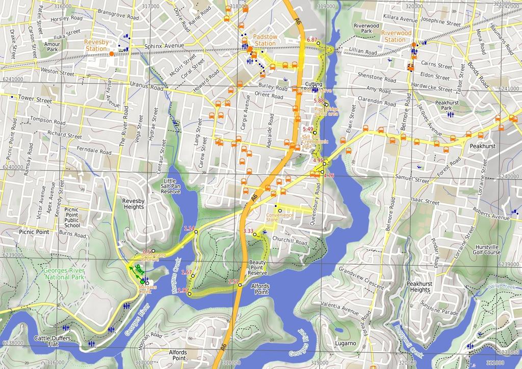
1 Morgans Creek to Padstow 2 hrs 45 mins 8 km One way Moderate track 3 144m This pleasant walk starts from the Morgans Creek park, at Henry Lawsons Drive, and follows the Georges River past the Boomerang Reserve, winding through the bush around Mickeys Point and under the Alfords Point bridge. The walk then continues up through Padstow Heights to the Henry Lawson Drive Bridge where it follows the boardwalks, bushtracks and service trails along Salt Pan Creek. The last section is along the roads to Padstow station. 46m 0m Georges River National Park Maps, text & images are copyright wildwalks.com Thanks to OSM, NASA and others for data used to generate some map layers.
2 Morgans Creek Before You walk This large, riverside area starts at the intersection of Henry Lawson Drive and The River Road, following the 'Georges River National Park' sign down the driveway, where it passes a large car park for the boat ramp and bends around to the right, continuing along the side of the river with several picnic areas and plenty of open space. There are toilets and taps at the northern end of the reserve, at the car park for the boat ramp. Bushwalking is fun and a wonderful way to enjoy our natural places. Sometimes things go bad, with a bit of planning you can increase your chance of having an ejoyable and safer walk. Before setting off on your walk check Boomerang Reserve This relatively small park can be found on Henry Lawson drive, between the Little Salt Pan creek and The River road. The park is surrounded by dense forest on three sides and a small timber barrier on the road side. The park has a few sheltered picnic benches and a large map of Bankstown that was erected by the local Rotary club. There is plenty of open space and a few nice large trees for shade. Convenience Store This great little convenience store can be found on the corner of Villiers and Dilke Roads, and serves hot food, ice creams and cold drinks, as well as many convenient groceries. There is a public phone out the front. The store is open 7 days. Salt Pan Creek picnic area This small picnic area on the Salt Pan Creek walking track can be accessed directly from the stairs at the end of Werona Ave. This clearing provides a couple of picnic benches and tables, natural shade and a small, grassy clearing. The space if big enough for a bit of running around or to spread out a picnic blanket. The picnic area is on the edge of Salt Pan Creek, with dense mangroves along to river bank. There are a number of houses overlooking the area from the cliffs above. Pipe bridge picnic area This small picnic area has a collection of low picnic tables in a grassy clearing by the edge of the Salt Pan Creek. The large pipe bridge crossing the creek provides some shade during the heat of the day. There are no water or toilet facilities. The unfenced edge of the picnic area provides clear access to the creek. This is one of the few spots along Salt Pan Creek walk where there is a clear view of the creek. 1) Weather Forecast (BOM Metropolitan District) 2) Fire Dangers (Greater Sydney Region) 3) Park Alerts (Georges River National Park) 4) Research the walk to check your party has the skills, fitness and equipment required 5) Agree to stay as a group and not leave anyone to walk solo Think before you TREK The 'Think before you TREK' program developed by NSW Police & NPWS promotes the benefits of planning ahead for your bushwalking trip by using an easy to remember acronym: adequate supplies of food, water, navigation and first T Take aid equipment. your planned route and tell friends and family when R Register you expect to return. beacon (PLB's) should be carried on walks with E Emergency significant gaps in mobile coverage (check terrain profile). to your planned route and follow the map and walking K Keep trails. Topo Maps The maps provided on wildwalks are helpful, but there are times where you may need maps covering a broader area. Maps that cover this walk include; 1: Map Series:91303S BOTANY BAY 1: Map Series:9130 SYDNEY Grade This walk has been graded using the AS The overall grade of the walk is dertermined by the highest classification along the whole track. 3 Grade 3/6 Moderate track Length 8 km One way Time 2 hrs 45 mins Quality of track Formed track, with some branches and other obstacles (3/6) Signs Directional signs along the way (3/6) Experience Required Some bushwalking experience recommended (3/6) Weather Weather generally has little impact on safety (1/6) Infrastructure Limited facilities, not all cliffs are fenced (3/6)
3 Are you ready to have fun? Please ensure you and your group are well prepared and equipped for all possible hazards and delays. Check park closures, weather information and Fire Danger Rating before setting out. Optional side trips and alternate routes noted are not included in this walks overall grade, length or time estimate. Please allow extra time for resting and exploring areas of interest. The authors, staff and owners of wildwalks take care in preparing this information but will not accept responsibility for any inconvenience, loss or injury you may experience. Please take care, have fun - Happy Walking. Getting there You can get to Int of Morgans Creek and the Ridge Track (gps: , ) by car or bus. Car: There is free parking available. You can get back from Padstow Railway Station (gps: , ) by car, train or bus. Car: There is free parking available. Find up to date and more information inlcuding; travel directions, weather, park closures and walker feedback at 0 Morgans Creek This large, riverside area starts at the intersection of Henry Lawson Drive and The River Road, following the 'Georges River National Park' sign down the driveway, where it passes a large car park for the boat ramp and bends around to the right, continuing along the side of the river with several picnic areas and plenty of open space. There are toilets and taps at the northern end of the reserve, at the car park for the boat ramp. 0 Int of Morgans Creek and the Ridge Track (570 m ) From the intersection, the walk follows the road up the gentle hill, passing the entry ticket booth and coming to the intersection with Henry Lawson Drive. Turn right: From the intersection, the walk follows Henry Lawson drive, keeping Georges River to the right. The road bends to the right and soon reaches Boomerang Reserve, on the left Boomerang Reserve This relatively small park can be found on Henry Lawson drive, between the Little Salt Pan creek and The River road. The park is surrounded by dense forest on three sides and a small timber barrier on the road side. The park has a few sheltered picnic benches and a large map of Bankstown that was erected by the local Rotary club. There is plenty of open space and a few nice large trees for shade Boomerang Reserve (570 m ) Continue straight: From the intersection, the walk follows Henry Lawson drive, keeping the river to the right. The road crosses the Little Salt Pan creek bridge then heads up to the intersection with the Georges River service trail, on the right (approximately 150 metres past the bridge) Int of the Henry Lawson drive and Georges River Na (530 m ) Turn right: From the intersection, the walk follows the service trail away from the road, around the metal gate and towards Mickeys Point. The trail winds past mangroves and through thick bush until it comes out at a large open clearing. At the other end of the clearing the service trail ends at a small turning circle End of Gorges river service trail (230 m 4 mins) Continue straight: From the end of the service trail, the walk follows the bush track through the long grass towards the river. At the river, the track turns left and meanders up and down along the side of the river, until reaching the start (western end) of a long sandy beach. 1.9 West end of Mickeys Point Beach (600 m ) Continue straight: From the end of the bush track, the walk follows the beach (keeping the water on the right). The walk stays on the beach until reaching the base of the large Alfords Point bridge Base of Alfords Point Bridge (320 m 6 mins) Continue straight: From the base of the bridge, the walk heads off the sand and winds around mangroves and through reeds (keeping the river on the right). After the clearing on the left, the walk comes to the sandy One Tree point service trail, near the trees Int of One Tree Point service trail (500 m 12 mins) Veer left: From the intersection, the walk follows the old service trail away from the river. The trail passes through the reeds and the pine trees as it winds up a steep rocky hill. At the top of the hill, the trail passes under the powerlines, bends to the left and soon reaches an intersection with a bush track, to the right. Continue straight: From the intersection, the walk follows the bush track beside the powerlines up the small hill to the metal gate at the bend in Playford Rd Int of One Tree Point bushtrack and Playford road (510 m 8 mins) Turn right: From the intersection, the walk follows the footpath along Playfords road to the north-east, keeping the road on the right. The walk continues to follow Payford Rd when it bends to the right (at the intersection with Roma avenue), then turns left into Dilke road at the 'T' intersection. The walk continues to the intersection with Villers Rd (there is a corner store and public phone on the left plus a large water tank on the right) Convenience Store This great little convenience store can be found on the corner of Villiers and Dilke Roads, and serves hot food, ice creams and cold drinks, as well as many convenient groceries. There is a public phone out the front. The store is open 7 days Int of Villiers and Dilke road (920 m 15 mins) Turn right: From the intersection, the walk follows Villiers road east (initially keeping the water tank on the right). Soon, the walk turns left onto Queensbury road and follows it, before turning right at the 'T' intersection onto Richmond avenue. The walk immediately turns left onto Riverview road, and continues to the end of the road End of Riverview road (190 m 3 mins) Turn left: From the end of the road, the walk follows the concrete footpath (following the power lines) between house numbers 5 and 6. After a short distance the walk reaches the footpath on Henry Lawson Drive. Turn right: From the intersection, the walk follows the footpath on Henry Lawson drive down the hill, (keeping the road on the left) towards the bridge. Just before the bridge, the walk comes to the top of a wooden staircase, to the right Western end of Salt Pan Creek Bridge (550 m ) Turn right: From the intersection, this walk follows the boardwalk down the wooden staircase and loops around under the bridge. The walk passes a few picnic chairs and winds around through some mangroves, following the boardwalk to the intersection of the Alma Road concrete footpath track on the left. Turn right: From the intersection, this walk follows the footpath north (keeping the river on the right) onto a bush track and then up some wooden steps. The track continues along for a while until it drops down some more steps to the Salt Pan creek picnic area Salt Pan Creek picnic area This small picnic area on the Salt Pan Creek walking track can be accessed directly from the stairs at the end of Werona Ave. This clearing provides a couple of picnic benches and tables, natural shade and a small, grassy clearing. The space if big enough for a bit of running around or to spread out a picnic blanket. The picnic area is on the edge of Salt Pan Creek, with dense mangroves along to river bank. There are a number of houses overlooking the area from the cliffs above Salt Pan Creek picnic area (390 m 7 mins) Continue straight: From the picnic area, this walk follows the bush track up the steps (keeping the river on the right) and winds along the side of Salt Pan Creek until it drops back down some steps onto a boardwalk. The track continues along the boardwalk, alongside the creek, until it comes to the bottom of Weenamana Place steps on the left. Continue straight: From the bottom of the steps, this walk follows the boardwalk as it winds alongside the river (keeping the river on the right), through mangroves for a short while. Soon the boardwalk becomes a bush track and continues to the picnic area under the large pipe bridge Pipe bridge picnic area This small picnic area has a collection of low picnic tables in a grassy clearing by the edge of the Salt Pan Creek. The large pipe bridge crossing the creek provides some shade during the heat of the day. There are no water or toilet facilities. The unfenced edge of the picnic area provides clear access to the creek. This is one of the few spots along Salt Pan Creek walk where there is a clear view of the creek Picnic area at base of Pipe Bridge (280 m 6 mins) Continue straight: From the picnic area, the walk follows the hardened management trail (keeping the creek on the right) as it winds along the side of the river. The walk passes a fenced-off area on the left before it turns left heads up the hill, coming near to the play equipment at Davies Reserve Davies Reserve This park can be accessed from the end of Tallawarra Ave or directly from Davies Road in Padstow. The Reserve is one of the spots along the Salt Pan Creek walking track. The facilities provided at this reserve include play equipment, a toilet block and picnic tables and seats. There is plenty of open space, and shade from a few large trees. There is parking for about 20 cars Davies Reserve (700 m 13 mins) Turn right: From Davies Reserve, this walk follows the fenced boardwalk running parallel to the power lines, keeping Salt Pan Creek on the right. The track passes through the wetlands for a short distance, coming to an intersection with the Truro Parade boardwalk on the left. Continue straight: From the intersection, the walk continues along the short board walk (keeping the power lines above to the right). Soon the boardwalk joins onto a hardened footpath, which continues along through the grass clearing, running parallel to Salt Pan Creek. The track passes behind a number of houses, and then passes a couple of transmission towers as the footpath tends left to the end of Meager Avenue. Veer right: ###This section of the track is closed for End of 2010 to sometime in Please walk along Meager Ave to Davies Rd as an alternate route### From the end of Meager Ave, the walk follows the footpath lined with wooden posts (with the white house at no.2 initially on the left) into the bush and down the gentle hill. After a short distance, the footpath joins a board walk and continues through some mangroves and out
 and through some mangroves for a short distance, until coming to a")
4 to the creek edge. The boardwalk then turns left, crossing under the railway bridge to the intersection with the Salt Pan Creek footbridge on the right. Turn left: From the intersection, this walk follows the boardwalk around the creek's edge (keeping the train line on the left) and through some mangroves for a short distance, until coming to a concrete footpath. This path continues past a transmission tower to the end of Bridge Street End of Bridge Street (1.1 km 19 mins) Turn left: From the car park at the end of the street, this walk follows the foot path along Bridge Street to the 'T' intersection of Davies Road, where the walk turns left. Following the footpath, this walk soon crosses the railway bridge and comes to the intersection with Meager Avenue. Continue straight: From the intersection, this walk heads south (away from the trail line) along Davies Road, along the footpath. After a short while, the walk turns right into Ryan Rd, crossing at the traffic lights. This walk follows the footpath through the suburbs to cross, straight ahead at the roundabout, onto Howard Road. The road then passes a few shops and comes to the Padstow railway station on the right.
5
6 Summary navigation sheet for the Morgans Creek to Padstow km From 0.00 Int of Morgans Creek and the Ridge Track , (GR Botany Bay, ) Boomerang Reserve , (GR Botany Bay, ) Int of the Henry Lawson drive and Georges River National Park service trail , (GR Botany Bay, ) m 570 m 530 m From the intersection, the walk follows the road up the gentle hill, passing the entry ticket booth and coming to the intersection with Henry Lawson Drive. Continue straight: From the intersection, the walk follows Henry Lawson drive, keeping the river to the right. End of Gorges river service trail , (GR Botany Bay, ) West end of Mickeys Point Beach , (GR Botany Bay, ) Base of Alfords Point Bridge , (GR Botany Bay, ) Int of One Tree Point service trail , (GR Botany Bay, ) Int of One Tree Point bushtrack and Playford road , (GR Botany Bay, ) Int of Villiers and Dilke road , (GR Botany Bay, ) End of Riverview road , (GR Botany Bay, ) Western end of Salt Pan Creek Bridge , (GR Botany Bay, ) Salt Pan Creek picnic area , (GR Botany Bay, ) Picnic area at base of Pipe Bridge , (GR Botany Bay, ) Davies Reserve , (GR Botany Bay, ) End of Bridge Street , (GR Botany Bay, ) m 4 mins 600 m 320 m 6 mins 500 m 12 mins 510 m 8 mins 920 m 15 mins 190 m 3 mins 550 m 390 m 7 mins 280 m 6 mins 700 m 13 mins 1.1 km 19 mins Continue straight: From the end of the service trail, the walk follows the bush track through the long grass towards the river. Continue straight: From the end of the bush track, the walk follows the beach (keeping the water on the right) Powered by TCPDF ( Up/Dwn Length Initial directions (Use full tracknotes and maps for more detail) Turn right: From the intersection, the walk follows the service trail away from the road, around the metal gate and towards Mickeys Point. Continue straight: From the base of the bridge, the walk heads off the sand and winds around mangroves and through reeds (keeping the river on the right). Veer left: From the intersection, the walk follows the old service trail away from the river. Turn right: From the intersection, the walk follows the footpath along Playfords road to the north-east, keeping the road on the right. Turn right: From the intersection, the walk follows Villiers road east (initially keeping the water tank on the right). Turn left: From the end of the road, the walk follows the concrete footpath (following the power lines) between house numbers 5 and 6. Turn right: From the intersection, this walk follows the boardwalk down the wooden staircase and loops around under the bridge. Continue straight: From the picnic area, this walk follows the bush track up the steps (keeping the river on the right) and winds along the side of Salt Pan Creek until it drops back down some steps onto a boardwalk. Continue straight: From the picnic area, the walk follows the hardened management trail (keeping the creek on the right) as it winds along the side of the river. Turn right: From Davies Reserve, this walk follows the fenced boardwalk running parallel to the power lines, keeping Salt Pan Creek on the right. Turn left: From the car park at the end of the street, this walk follows the foot path along Bridge Street to the 'T' intersection of Davies Road, where the walk turns left.
Currie Rd to Davidson Park
 Currie Rd to Davidson Park 3 hrs 7.2 km One way Moderate track 28m Starting at Currie Rd in Forestville, this walk follows Middle Harbour to Davidson Park, under Roseville Bridge. There are two optional
Hunters Hill to Epping Road
 Hunters Hill to Epping Road 2 hrs 30 mins 5.5 km One way Moderate track 154m An enjoyable walk through lower sections of the Lane Cove National Park, this walk features plenty of mangroves next to the
Heathcote to Engadine via Audley
 Heathcote to Engadine via Audley 6 hrs 3 mins 5 km One way Hard track 4 635m Covering a large section of central Royal National Park, this walk goes through the heath and scrub along a well managed and
Epping to Pennant Hills Station (via Lane Cove River)
") Epping to Pennant Hills Station (via Lane Cove River) 3 hrs 5 mins 8.4 km One way Hard track 249m This walk, from Epping to Pennant Hills Station, is a great way to see the upper Lane Cove River Valley.
Epping to Pennant Hills Station (via Lane Cove River) 3 hrs 5 mins 8.4 km One way Hard track 249m This walk, from Epping to Pennant Hills Station, is a great way to see the upper Lane Cove River Valley.
The Foreshore Walk. 24m. 1m Lake Macquarie LGA. 1 hr 15 mins 2.9 km One way. Hard track 81m
 The Foreshore Walk 1 hr 15 mins 2.9 km One way Hard track 81m This walk traverses the coastline of the Green Point reserve. By following a variety of tracks and occasionally traveling inland through eucalyptus
Waterfall to Heathcote
 Waterfall to Heathcote 5 hrs Hard track 10.8 km One way 4 467m This walk explores the heart of Heathcote National Park, and is easily accessed with a train station at either end. Although relatively close
Carrington Park to Leura Forest and pass loop
 Carrington Park to Leura Forest and pass loop 3 hrs Hard track 4.8 km Circuit 4 674m This walk is a fantastic way to see Leura Forest. The walk descends from Carrington Park, visiting Leura Forest and
Govetts Leap Loop. 1065m. 909m Blue Mountains National Park. 4 hrs 30 mins 8.7 km Circuit. Hard track 380m
 Govetts Leap Loop 4 hrs 30 mins 8.7 km Circuit Hard track 380m This walk, from Blackheath Train Station, is a fantastic way to see some of the iconic areas of the Blue Mountains in the Blackheath area.
Teralba to Charlestown Park track head
 Teralba to Charlestown Park track head 4 hrs 30 mins 13.3 km One way Moderate track 3 220m This section of the Great North Walk starts from the Teralba train station and winds down and around the edge
Wentworth Falls Conservation Hut Loop
 Wentworth Falls Conservation Hut Loop 3 hrs Hard track 6.7 km Circuit 4 341m This scenic walk from Wentworth Falls Station, winds along the Nature Trail to Conservation Hut, then drops into the magnificent
Echo Point to Leura Forest via Three Sisters and Giant Stairs loop
 Echo Point to Leura Forest via Three Sisters and Giant Stairs loop 3 hrs 3.8 km Circuit Hard track 512m This walk starts from the popular Echo Point, in Katoomba, and winds down to the base of the Three
Katoomba Falls Circuit
 Katoomba Falls Circuit hr 5 mins.5 km Circuit Hard track 59m For those looking for a walk involving more than simple boardwalk, this trail winding through the temperate rain forest could be just the thing.
Sid Pulsford Walk. 175m. 33m. 1 hr 45 mins 4.1 km One way. Hard track 118m. Gosford LGA
 Sid Pulsford Walk 1 hr 5 mins.1 km One way Hard track 118m Sid Pulsford Walk explores the ridge top of Kincumber Mountain, from Honeman's Rock to Green Point. The walk mostly follows wide management trails.
Rail to River Walk. 3 hrs. Hard track 7.5 km Circuit. 222m
 Rail to River Walk 3 hrs Hard track 7.5 km Circuit 4 222m This walk is a great one from Chatswood Station to the Lane Cove River National Park. The walk descends through the vegetated bushland which fills
Popes Glen, Pulpit Rock, Govetts Leap and Braeside Walk
 Popes Glen, Pulpit Rock, Govetts Leap and Braeside Walk 8 hrs Hard track 13.6 km Circuit 4 1068m This large circuit walk, from Popes Glen to Pulpit Rock, Govetts leap and along the Braeside Track, passes
Dead Horse Gap Loop track
 Dead Horse Gap Loop track 4 hrs 30 mins Hard track 9.8 km Circuit 144m 4 This walk starts with a ride up the Kosciuszko Express Chairlift. There is an opportunity to eat at Australia's highest restaurant,
Little Digger Track to Davidson Reserve and Lyrebird Circuit
 Little Digger Track to Davidson Reserve and Lyrebird Circuit 4 hrs 3 mins 11.5 km One way Hard track 4 47m Exploring both the eastern and western sides of Middle Harbour Creek, this walk follows the Little
Wallarah Coastal Walk
 Wallarah Coastal Walk 3 hrs 8.3 km Return Hard track 247m This walk starts at Caves Beach and travels south along the coastline, until reaching the Pinney s Headland Lookout. There are many opportunities
Epping to Eastwood Station (via Lane Cove River)
") Epping to Eastwood Station (via Lane Cove River) hrs 45 mins 10.2 km One way Moderate track 189m Epping to Eastwood, via Lane Cove River, is the longer route through the bush between the stations. This
Epping to Eastwood Station (via Lane Cove River) hrs 45 mins 10.2 km One way Moderate track 189m Epping to Eastwood, via Lane Cove River, is the longer route through the bush between the stations. This
Hornsby Blue Gum Walk
 Hornsby Blue Gum Walk 3 hrs Hard track 6.7 km Circuit 4 374m This delightful loop is one of the prettiest and most popular walks in the Hornsby area. Going from an environment of ferns and clear bushland
Wattamolla to Big Marley Beach
 Wattamolla to Big Marley Beach 4 hrs 10.4 km Circuit Moderate track 4m This walk is an excellent loop which takes in both the coast and the heathy inland of Royal National Park. Nearly the whole walk has
Campbell Drive to Snapper Point
 Campbell Drive to Snapper Point 1 hr 45 mins 4.2 km One way Experienced only 135m This walk follows the Coast Track to Frazer Beach, along the Geebung and (overgrown) Grass Tree Tracks. From the northern
Rail to River and Stringybark Creek Reserve Walk
 Rail to River and Stringybark Creek Reserve Walk 4 hrs Hard track 11.2 km Circuit 4 302m This walk begins in the busy city of Chatswood and soon enters the nearby bushland around the Lane Cove River. The
Balmoral Beach to The Spit
 Balmoral Beach to The Spit 2 hrs 30 mins.3 km One way Hard track 85m This walks follows the coast from Balmoral to the Spit and across Spit Bridge. There are some alternate tracks to consider at high-tides,
Middle Harbour Creek Loop
 Middle Harbour Creek Loop 5 hrs 45 mins 15.1 km Circuit Experienced only 5 570m This walk explores the upper reaches of Middle Harbour Creek, starting and ending at the great parklands at Davidson Park,
Little Digger Track. 68m. 1 Hr 2.2 km One way. Moderate track 93m. Moores Creek Reserve
 Little Digger Track Hr 2.2 km One way Moderate track 93m This walk follows Moores Creek through several reserves in east Roseville and East Lindfield. The track is named after Australia's 7th Prime Minster,
Green Point Circuit Walk
 Green Point Circuit Walk 3 hrs 7.7 km Circuit Hard track 269m This walk visits all of the popular locations in Green Point Reserve, as well as some of the lesser-visited areas inland. Taking in Sea Eagle
Scenic World to Echo Point
 Scenic World to Echo Point 1 hr 15 mins 2.1 km One way Moderate track 192m This is one of the most popular tourist walks in the Katoomba area. The walk follows the cliffs along a well maintained and signposted
Mackerel Beach and Resolute Loop
 Mackerel Beach and Resolute Loop 3 hrs 5.4 km Circuit Hard track 384m This walk is another great walk in Ku-ring-gai Chase National Park, accessed by ferry. From the Mackerel Beach wharf, this walk uses
The Basin Track and Mackerel Track
 The Basin Track and Mackerel Track 3 hrs 5.9 km Circuit Hard track 226m This walk is a great way to see some popular areas in Ku-ring-gai Chase National Park. The walk from West Head Rd travels to The
Mackerel Beach, West Head Loop
 Mackerel Beach, West Head Loop 5 hrs 8.6 km Circuit Hard track 422m The Mackerel Beach, West Head Loop is a walk which explores a large part of the West Head. The journey starts and finishes with a ferry
De Burgs Bridge to Thornleigh station
 De Burgs Bridge to Thornleigh station 3 hrs 45 mins 9.7 km One way Hard track 4 363m This walk follows a section of the Great North Walk, starting from De Burghs bridge. The walk winds north west, through
Callicoma Loop. 174m. 98m. 2 hrs. Hard track 5.1 km Circuit. 153m
 Callicoma Loop 2 hrs Hard track 5.1 km Circuit 153m This great circuit walk passes through some really nice forest around the fringe of Cherrybrook. Highlights of the walk include some beautiful rock overhangs
Woolwich Wharf to Boronia Park
 Woolwich Wharf to Boronia Park 2 hrs 5.8 km One way Moderate track 175m Going through the streets of Hunters Hill, this walk is on the first segment of the Great North Walk. The majority of the walk is
Berowra to Mt Kuring-gai
 Berowra to Mt Kuring-gai 4 hrs 30 mins 9.4 km One way Hard track 4 551m From the ridges above Cowan Creek, this walk takes in some great lookouts (especially around Mt Kuringgai) as well as enjoying an
Sphinx, Warrimoo and Bobbin Head tracks
 Sphinx, Warrimoo and Bobbin Head tracks 4 hrs 9.6 km Circuit Moderate track 499m This great walk starts at the Sphinx Memorial and loops around via Cowan Creek, exploring diverse environments as it changes
Spit Bridge to Middle Head Forts
 Spit Bridge to Middle Head Forts 2 hrs 30 mins 6.3 km One way Hard track 4 181m This scenic walk takes you from the Spit Bridge, along the coast to explore the Middle Head Forts. There are a few alternate
Bouddi Coastal Walk. 5 hrs. Hard track 8.1 km One way. 364m
 Bouddi Coastal Walk 5 hrs Hard track 8.1 km One way 4 364m This is one of the longer walks in the Bouddi National Park and it is rich in scenery. The walk follows the coastline with many side trips to
Under and Over Cliff Walk
 Under and Over Cliff Walk 4 hrs 9.4 km Circuit Moderate track 576m This walk from Wentworth Falls Station is a fantastic way to see a large majority of the Wentworth Falls cliffline. The track winds under
Upper Rumbalara circuit
 Upper Rumbalara circuit 1 hr 30 mins 3.3 km Circuit Hard track 176m A great circuit walk, covering most of the walking tracks and sights in the upper section of the Rumbalara Reserve. There is some really
Epping to Gordon Station
 Epping to Gordon Station 4 hrs 15 mins 11.7 km One way Hard track 4 365m This walk, from Epping Station to Gordon Station, passes below the homes which sit on the hills high above the Lane Cove River.
De Burghs Bridge to Fullers Bridge
 De Burghs Bridge to Fullers Bridge 2 hrs 3 mins Hard track 6 km One way 2m 4 Following the Lane Cove River, this walk mostly follows a section of the Great North Walk and is well maintained and signposted.
Taronga Wharf to Chowder Bay
 Taronga Wharf to Chowder Bay 2 hrs 4.4 km One way Moderate track 246m Starting at Taronga Wharf, this walk passes many icons of Sydney, including Taronga Zoo, HMAS Sydney Mast, Chowder Bay. The walk also
National Pass from Wentworth Falls to Conservation Hut
 National Pass from Wentworth Falls to Conservation Hut 3 hrs Hard track 3.6 km One way 739m Starting at Wentworth Falls picnic area, this scenic and historic walk explores many waterfalls, lookouts and
Blackheath Station to Junction Rock Loop (via Grand Canyon and Popes
 Blackheath Station to Junction Rock Loop (via Grand Canyon and Popes 8 hrs 30 mins 18.2 km Circuit Hard track 4 1254m This circuit starts in Blackheath and heads down into the Grand Canyon and Rodriguez
Patonga to Woy Woy. 5 hrs 45 mins 15.5 km One way. Hard track. 497m
 Patonga to Woy Woy 5 hrs 45 mins 15.5 km One way Hard track 4 497m This walk explores a variety of environments from the shore line and coastal cliffs near Patonga, to the dry, rocky and open ridge line.
Wentworth Falls Station Loop (Undercliff Walk)
") Wentworth Falls Station Loop (Undercliff Walk) 4 hrs 3 mins Hard track 8.9 km Circuit 658m 4 This walk passes some stunning waterfalls and views into the Jamison Valley, following the cliff edges around
Wentworth Falls Station Loop (Undercliff Walk) 4 hrs 3 mins Hard track 8.9 km Circuit 658m 4 This walk passes some stunning waterfalls and views into the Jamison Valley, following the cliff edges around
Roseville to Macquarie Park
 Roseville to Macquarie Park 3 hrs 3 mins 8.8 km One way Hard track 4 29m This walk starts at Roseville station and explores the streets and alleyways of Roseville before joining the main spine of the Great
Federal Pass Walking Track
 Federal Pass Walking Track 5 hrs Hard track 8 km One way 4 989m This classic trail follows along the base of the cliffs from Leura to the Golden Stairs, passing many of the more popular sights of the Katoomba
Wentworth Falls Station Loop
 Wentworth Falls Station Loop 5 hrs 3 mins 9.5 km Circuit Hard track 4 13m The Wentworth Falls Station Loop takes in most of the upper tracks around Wentworth Falls. There are many scenic views near the
Hermitage Foreshore Track
 Hermitage Foreshore Track 1 Hr 2.2 km One way Moderate track 123m The Hermitage Foreshore Walk is a wonderful way to explore Sydney Harbour from the perspective of South Head. This walk starts from Nielsen
Dubbo Gully and Ten Mile Hollow Circuit (via Clares Bridge)
") Dubbo Gully and Ten Mile Hollow Circuit (via Clares Bridge) 2 Days Hard track 24.3 km Circuit 4 1117m This two day (or ten hour) walk follows several historic roads, now closed to traffic. Starting with
Dubbo Gully and Ten Mile Hollow Circuit (via Clares Bridge) 2 Days Hard track 24.3 km Circuit 4 1117m This two day (or ten hour) walk follows several historic roads, now closed to traffic. Starting with
Gordon to Chatswood Station
 Gordon to Chatswood Station 4 hrs 30 mins 12.2 km One way Hard track 4 381m This walk is a great way to get into the bush without being far from civilisation. The walk wanders through untouched valleys
Wentworth Falls Loop. 893m. 665m. 6 hrs 10.2 km Circuit. Hard track 1093m. Blue Mountains National Park
 Wentworth Falls Loop 6 hrs 1.2 km Circuit Hard track 193m This is a great walk, both in size and spectacular views. The walk makes its way from Wentworth Falls train station and drops off the plateau,
Charlestown Park trackhead to Newcastle station
 Charlestown Park trackhead to Newcastle station 5 hrs 30 mins 12.1 km One way Hard track 4 287m This section of the Great North Walk starts from the Charleston Park track head and winds through the streets
Echo Point to Leura Forest Circuit
 Echo Point to Leura Forest Circuit 3 hrs 4.8 km Circuit Hard track 588m Forming a circuit around the cliffs and then the valley floor, this is a walk more then capable of convincing a walker of the beauty
North Ryde Fairyland circuit
 North Ryde Fairyland circuit 2 hrs 30 mins Hard track 6.9 km Circuit 193m 4 Starting at North Ryde train station this walk explores a stretch of the Lane Cove River, visiting the historic Fairlylands Pleasure
Spit Bridge to Manly (Manly Scenic Walkway)
") Spit Bridge to Manly (Manly Scenic Walkway) 3 hrs 45 mins 9.1 km One way Moderate track 349m The Spit to Manly walk is a classic bushwalk on Sydney's Northern Beaches. The walk follows a well-maintained
Spit Bridge to Manly (Manly Scenic Walkway) 3 hrs 45 mins 9.1 km One way Moderate track 349m The Spit to Manly walk is a classic bushwalk on Sydney's Northern Beaches. The walk follows a well-maintained
Glenbrook and Euroka Circuit
 Glenbrook and Euroka Circuit 2 Days 16.6 km Circuit Experienced only 790m This two day circuit, returning to Glenbrook Station, is a scenic walk which passes many of the tourist attractions within the
Thornleigh to Hornsby
 Thornleigh to Hornsby 4 hrs Hard track 10.2 km One way 4 526m Starting at Thornleigh station you walk through suburban streets for a short while before diving into the bush at the southern end of Berowra
Rumbalara Explorer. 158m. 5m Rumbalara Reserve. 2 hrs 45 mins 6.1 km Circuit. Hard track 326m
 Rumbalara Explorer 2 hrs 5 mins 6.1 km Circuit Hard track 326m Pretty well the grand tour of the Rumbalara Reserve, this walk takes in much of the great scenery the reserve has to offer. The walk covers
Cape Banks Circuit. 50m. 2m Botany Bay National Park. 3 hrs 7.3 km Circuit. Hard track 190m
 Cape Banks Circuit 3 hrs 7.3 km Circuit Hard track 19m This Cape Banks Circuit has a lot to offer and is thoroughly recommended. The walking travels over beaches, through coastal forest and across exposed
Lane Cove Tourist Park River Circuit
 Lane Cove Tourist Park River Circuit 5 hrs 12 km Circuit Hard track 383m This walk follows a large section of Lane Cove River. The walk follows the Riverside Walking track up the Lane Cove River to De
Sphinx to Mt Kuring-gai
 Sphinx to Mt Kuring-gai 4 hrs 45 mins 1.7 km One way Hard track 673m This walk starts at the Sphinx War Memorial and follows some well maintained and popular walking tracks down to Cowan Creek. Enjoy the
Narrabeen Lagoon Trail (from Middle Creek)
") Narrabeen Lagoon Trail (from Middle Creek) 2 hrs 30 mins 8.6 km Circuit Very easy 1 105m The Narrabeen Lagoon Trail is a wonderful and accessible walk on the Northern Beaches of Sydney. The trail is used
Narrabeen Lagoon Trail (from Middle Creek) 2 hrs 30 mins 8.6 km Circuit Very easy 1 105m The Narrabeen Lagoon Trail is a wonderful and accessible walk on the Northern Beaches of Sydney. The trail is used
The Coast Track. 2 Days. Hard track 27.4 km One way. 1351m
 The Coast Track 2 Days Hard track 27.4 km One way 4 1351m Heading south, this walk covers the coastline of the Royal National Park and can truly only be described as amazing. With breathtaking coastal
Scenic world to Three Sisters Loop via Furber Steps
 Scenic world to Three Sisters Loop via Furber Steps 5 hrs 5.8 km Circuit Hard track 722m This walk starts from the popular Scenic World, in Katoomba, and winds down the Furber steps into the Jamison Valley,
Gosford to Lisarow. 202m
 Gosford to Lisarow 4 hrs 3 mins Hard track 11.3 km One way 4 479m This walk is a great way to explore the ridge-top bushland between Gosford and Lisarow. Passing through Rumbalara and Katandra Reserves,
Bobbin Head Loop. 166m. 0m Ku-ring-gai Chase National Park. 5 hrs 12.9 km Circuit. Hard track 619m
 Bobbin Head Loop 5 hrs 12.9 km Circuit Hard track 619m This great circuit walk enjoys a variety of landscapes in Ku-ring-gai Chase National Park. The walk starts at the historic Sphinx war memorial and
Manly to Seaforth Oval
 Manly to Seaforth Oval 5 hrs 45 mins 13.7 km One way Moderate track 3 624m This walk follows the Manly to Spit Scenic Walkway, then continues past The Spit Bridge to Seaforth Oval. The walk provides magnificent
Faulconbridge to Blaxland
 Faulconbridge to Blaxland 2 Days Experienced only 15.2 km One way 5 693m This two-day walk, or very solid one-day walk, takes you from station to station, through lush, scenic forest in the lower Blue
Bouddi Ridge and Coastal Walk
 Bouddi Ridge and Coastal Walk 2 Days Hard track 27 km Circuit 4 126m This overnight walk takes in the majority of the magnificent Bouddi National Park. The walk starts from the pleasant Putty Beach camping
Chatswood to Epping Station
 Chatswood to Epping Station 6 hrs Hard track 16.3 km One way 4 533m This walk, from Chatswood to Epping, is a long but enjoyable walk along the Lane Cove valley. The walk mostly follows the Lane Cove River
Taronga Zoo to Spit Bridge
 Taronga Zoo to Spit Bridge 5 hrs Hard track 1.4 km One way 4 41m This is a scenic and culturally rich walk with views over Sydney Harbour and many interesting heritage buildings along the way. The start
Light to Light Walk 2 days
 Light to Light Walk 2 days 2 Days Hard track 3.9 km One way 4 794m Over two days, this classic walk explores the coast from Boyd Tower to the Green Cape Lighthouse in the south. Hegartys Bay Camp is over
Sydney to Thornleigh via Lane Cove Tourist Park
 Sydney to Thornleigh via Lane Cove Tourist Park 2 Days 33 km One way Hard track 4 1114m This overnight walk starts from the Obelisk in Macquarie Park, Sydney, at the official start of the Great North Walk.
Six Foot Track. 1212m
 Six Foot Track 3 Days 44.8 km One way Hard track 4 2066m This classic walk takes you from Katoomba to Jenolan Caves via a historic horse route. The walk travels mainly along well-maintained service tracks
A Walk from Our Lady of Victories Church, Bowen Hills to The Cathedral of Saint Stephen
 A Walk from Our Lady of Victories Church, Bowen Hills to The Cathedral of Saint Stephen 1 0.0km 30m 185m 270m From the Start to Breakfast Creek Rd is 8 minutes This pilgrimage walk should take the average
Start / Finish. Version 2
 Start / Finish Version 2 Gosford (Start) to Woy Woy Head South down Etna Street, crossing Henry Parry Drive, then Mann St, Gosford, where Etna St becomes Racecourse Road. Follow this road all the way
Directions for Day 1: Colwood To Metchosin
 Colwood-Metchosin Page 1 of 8 Directions for Day 1: Colwood To Metchosin Start: Royal Roads University, Birds of a Feather B&B, or at Esquimalt Lagoon Finish: Your accommodation in Metchosin Time: 4-5
The Year Of Mercy Pilgrimage Sts Peter and Paul s Church, Bulimba To The Cathedral of St Stephen
 The Year Of Mercy Pilgrimage Sts Peter and Paul s Church, Bulimba To The Cathedral of St Stephen Dist Route Photos Photos 0.0km St Peter and Paul s Church, 235 Riding Rd & Cnr Main Ave, Balmoral. http://www.bulimbacatholic.com/
SELF GUIDED TOURING ROUTE
 SELF GUIDED TOURING ROUTE Things to see and places to go on the loop from Orbost to Marlo, Cape Conran, Cabbage Tree and back to Orbost (or onwards to Cann River) V6 April 2017 This guide should be read
Harbour Bridge to Taronga Zoo
 Harbour Bridge to Taronga Zoo 4 hrs 9.8 km One way Moderate track 389m On this walk, you will explore much of the foreshore linking Milsons Point Station to Taronga Zoo Ferry wharf. The walk is mostly
LDWA SOUTH DOWNS MARATHON 13 th MAY 2018
 AHD ahead SDW South Downs Way BL/BR bear left/bear right TL/TR turn left/turn right X cross LEG 1 - EAST DEAN to WP1 NORTON GR 470019. Open 1030 to 1300. 9.7 miles. 1.1 From village hall TL and walk to
Access Statement for Loch of Strathbeg
 This access statement does not contain personal opinions as to our suitability for those with access needs, but aims to accurately describe the facilities and services that we offer all our guests/visitors.
ULTRA-TRAIL AUSTRALIA May 2018 COURSE DESCRIPTION AND COURSE NOTES
 ULTRA-TRAIL AUSTRALIA 100 19-20 May 2018 COURSE DESCRIPTION AND COURSE NOTES LEG 1 Scenic World (Start) to Narrow Neck (Checkpoint 1) Course Description: From the start, at the front entrance of Scenic
Detailed Descriptions and Maps of Woodside s Nature Trails
 Detailed Descriptions and Maps of Woodside s Nature Trails Access Mill Road Trail Park along Anderson Mill road. Signs on West Pleasant Colony and Anderson Mill road clearly point to the beginning of the
VERN S CAMP from Minginui
 VERN S CAMP from Minginui Map: Kuratau, 1:50,000 V18 Refer Figures 1, 3, 4 and 5 GPS: Geodetic Datum 1949 Refer Figure 10a (Geographic) and 10b (NZ Grid) How to get to START: From the police station on
Walking Audit Supporting Information
 Walking Audit Supporting Information Planning to do a walking audit of your streets? Here s some helpful suggestions to help get you started. 1. Preparing for your audit Decide where you want to walk.
THE WELLDIGGERS ARMS, HESWORTH AND FITTLEWORTH TRAIL
 THE WELLDIGGERS ARMS, HESWORTH AND FITTLEWORTH TRAIL 5.5 miles Circular 3 hours 041017 Challenging Terrain A 300-year-old pub turned country-inn on the edge of the South Downs National Park, The Welldiggers
10 Miles Circular 5 hours
 VISIT RYEDALE PICKERING AND CAWTHORN CAMPS 10 Miles Circular 5 hours Moderate Terrain 120616 A 10 mile (16km) there and back walk from the market town of Pickering in Ryedale. The route heads north through
VELINDRE VALLEYS WALK FOR STEFFAN
 VELINDRE VALLEYS WALK FOR STEFFAN IMPORTANT INFORMATION FOR WALKERS AND MARSHALS 1 Table of Contents Key Contact Numbers:... 3 Timetable and locations... 4 T-shirts... 4 Important Advice for Walkers...
Dorridge & District Residents Association A Walk Along The Green Belt From Dorridge to Catherine-de-Barnes
 Dorridge & District Residents Association A Walk Along The Green Belt From Dorridge to Carine-de-Barnes The starting section of this walk through open fields would be destroyed by building of motorway
LDWA SOUTH DOWNS MARATHON
 AHD ahead SDW South Downs Way BL/BR bear left/bear right TL/TR turn left/turn right SP signpost/fingerpost X cross LEG 1 - EAST DEAN to WP1 NORTON GR 470019. Open 1030 to 1300. 9.6 miles. 1.1 From village
Hammer Vale and Linchmere Common
 point your feet on a new path Hammer Vale and Linchmere Common Distance: 9 km=5½ miles or 6 km=3¾ miles easy walking with one steep section Region: Hampshire, West Sussex Author: Botafuego Refreshments:
MAPS & WALK NOTES. DAY 2: Greenwich Wharf to Woolwich Wharf
 MAPS & WALK NOTES DAY 2: Greenwich Wharf to Woolwich Wharf Total Distance: 15.5km Time: Approximately 5 hours 30 mins five Sections Walk Notes in Section Name Length Time 2:1 Greenwich Wharf to Northwood
Beautiful Walks from the Blue Ball Inn
 Walk No. 7 COAST AND VALLEY WALK Countisbury, Glenthorne, County Gate, Brendon, Rockford and Wilsham 10 MILES APPROX. Walking time 5 hours approx. (not including breaks)> OS Sheet 64/74 Lynton and Lynmouth.
MMT 100 Crew Instructions
 MMT 100 Crew Instructions Updated for the 2018 Event While crews are welcome at the MMT, they can cause congestion and related problems. Crews must comply with the provisions on this page. Race management
MAP BOOKLET IMPORTANT CONTACTS SUNDAY 24 MARCH In an emergency please call 000 Medics. Event contacts
 SUNDAY 24 MARCH 2019 Help raise funds for the Cancer Centre for Children at The Children s Hospital at Westmead MAP BOOKLET IMPORTANT CONTACTS In an emergency please call 000 Medics (02) 8005 MEDIC or
RILLINGTON TO MALTON by Tania Dickinson
 RILLINGTON TO MALTON by Tania Dickinson This walk takes you from the Vale of Pickering up on to the Wold scarp, before dropping down again through the pretty village of Settrington and joining the Centenary