14 TH STREET TRANSPORTATION & STREETSCAPE DESIGN STUDY PLAN B PLAN B TRANSPORTATION & STREETSCAPE RECOMMENDATIONS
|
|
|
- Susanna Byrd
- 5 years ago
- Views:
Transcription
1 14 TH STREET TRANSPORTATION & STREETSCAPE DESIGN STUDY PLAN B PLAN B TRANSPORTATION & STREETSCAPE RECOMMENDATIONS 141


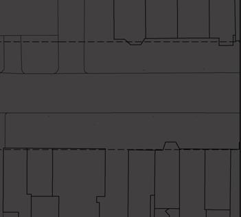
2 Symbols Recommendations - Southern End of 14th Street Study Area Streetscape Each icon represents a group of streetscape elements. The detailed description of each element is located in the Streetscape Elements Library. L1 L2 L3 Example of vehicular/pedestrian light placement. Recommended placement is 60 on center de LI1 H1 rho F1. F1 F2 F3 ave LI1 Example of furnishing placement. Bike racks, benches, and trash receptacles are placed in close vicinity to each other. The groups of furnishings are interspersed between tree boxes. Use Piano striping or concrete for crosswalks. nd L1 H6 isla National City Christian Church n street Streetscape S3 Bus shelters will be relocated to the new bulb-outs. Example of street tree, additional planting, and tree box placement. Standard tree planter size varies between 48 and 36 depending on sidewalk width. See Sidewalk Layout section for more information. P1 Smart Bike and public art opportunity. S2 SI1 S1 Thomas Circle Luther Place Memorial Church Transportation Bicycle Bulb-Out Car Share Transit Vehicular Transportation 142 See Transportation Recommendations section for detailed information. Consolidate bus stops and create bus bulb-outs for faster and more efficient service. Bus speed will improve by 15% Maximum walking distance to bus stop: 1.5 block. Vehicular LOS remains the same. In combination with multi-space parking meters, number of parking spaces increases by 15%. Establish 14th Street as a transit priority corridor and implement enhanced transit services ZipCar: Implement better parking regulations and enforcement for Zipcar sites, expand partnerships with public/private property owners. Establish new locations to serve new developments. Establish bike rental/storage centers SmartBike at major locations to serve the primary nodes/activity centers. Establish bulb-outs at all intersections Upgrade all corners to be ADA compliant. Bulb-outs promote better visibility of pedestrians. Bulb-outs promote better visibility for pedestrians. Pedestrian crossing distance decreases by 23%.


3 H4 Bike lane marking should include white lines at a minimum and colored marking for conflict zones. L5 H1 Road surface options include standard asphalt and permeable concrete, asphalt, or unit paver systems are recommended for the parking lanes. S1 r street q street p street H3 L4 Unit pavers or tumble finish concrete pavers are recommended for areas where the Planting Zone needs to be covered. The pavers are placed over the continuous root zone which encourages the uninterrupted growth of tree roots. corcoran street Functional public art opportunity for all four sides of the P & 14th Street intersection. church street P2 Bulb-outs create usable public open space. Allocating additional landscaping or LID devices in this space creates both an attractive and functional amenity. Multi-space parking meters located on each block. ~ foot spacing See Focus Area: P St. & 14th St. NW John Wesley African Methodist Episcopal Zion Church Studio tudio Theater Legend New Street Tree Existing Street Tree Create bulb-outs at T-intersections such as Wallach Place, Swann, Riggs, and Church Street. Upgrade all corners to be ADA compliant. Support the District of Columbia ia Bicycle Master M Plan and its proposed bicycle facilities in and around the study area. Integrate the bicycle/pedestrian requirements with transit options and land use planning/development process and require bicycle facility elements as part of the land development approval process. Maintain existing 4-lane configuration.. Implement signal retiming to give priorities to transit and pedestrians. Re-paint lane markings between bicycle lane, 2 travel lanes, double center lanes. Multi-space Parking Meter Trash Can Inverted U Bike Racks Streetlight Street Vending N NOTE: All streetscape and transportation recommendations noted on this plan apply to the entire 14th Street NW corridor from Thomas Circle to Florida Avenue. Bench Bus Stop Loading Zone Key Map Property Lines 143


4 Symbols Each icon represents a group of streetscape elements or transportation recommendations. Recommendations - Northern End of 14th Street Study Area H5 S7 All curb ramps should be brought up to code to comply with the Americans with Disabilities Act. LI2 Wherever feasible, pedestrian lighting should be installed between intersections. This will provide additional illumination of the sidewalk and improve safety along the corridor. S4 S5 S6 t street swann street Standard granite curbs and brick gutters are recommended. Consideration should be given to incorporating gutter filters, a functional LID device. s street Streetscape L5 Bulbouts create usable public open space. Allocating additional landscaping or LID devices in this space creates both an attractive and functional amenity. Historic District Signage, Wayfinding Signage, and Heritage Trail Signage should be installed at the appropriate locations along the corridor. Locations and specifications to be developed per DDOT Wayfinding Signage Program, DC Historic Preservation Office, and Cultural Tourism DC Venue Gallery Retention of existing curb cut and final bulb out location subject to coordination with adjacent stakeholders Black Cat Improve bicyclists safety through clear markings, drawing attention to conflict zones. Alternative bike lane layouts are discussed in the Transportation Recommendations section. Improve access management to minimize curb cuts along 14th Street. 144 USPS Post Office Source Theater Implement a multi-space pay/display parking system and convert all parking on 14th Street to central metered parking. Establish a variable pricing structure to encourage turnover and manage parking demand. Establish weekend meter parking regulations. Delay the start of meter parking from 7:00 AM to 9:00 AM and extend it to 8:00 PM on weekdays and to midnight on Friday and Saturday. Improve parking management on residential side streets with enhanced parking regulations and the use of multi-space meters. Establish 15-minute parking zones to meet the needs of customer loading at the blocks with strong short-term parking needs. Provide bicycle parking throughout the corridor to improve connection between bike and transit, between bike and carsharing locations, and between various activity centers in the study area. wallach place riggs street Transportation Maximize remote parking lots, including parking facilities south of Thomas Circle and in the Howard University area. Promote shared parking for existing and new developments.


 Coordinate, promote, and")


5 P2 Functional public art opportunity for all four sides of the U & 14th Street intersection. S2 L1 L2 L3 Example of street tree, additional planting, and tree box placement. Standard tree planter size varies between 48 and 36 depending on sidewalk width. See Sidewalk Layout section for more information. Smart Bike opportunity. SI1 F1 F2 F3 Example of furnishing placement. Bike racks, benches, and trash receptacles are placed in close vicinity to each other. The groups of furnishings are interspersed between tree boxes. Temporary or aluminum banners can be incorporated into the overall streetscape design to enhance the identity and image of the 14th St. NW corridor. P1 a av florid v street Reeves Municipal Center e. u street w street for permanent public art/gateway feature at the southern corners of Florida Ave. & 14th Street intersection. Lowest Price Gas Station The Solea Condo Development S2 See Focus Area: U St. & 14th St. NW Union Row Condo Development Busboys and Poets Retention of existing curb cuts and final bulb out location subject to coordination with adjacent stakeholders See Focus Area: Florida Ave. & 14th St. NW View 14 Condo Development Legend Facilitate better pedestrian crossing by implementing a lagging left at major intersections during rush hours New Street Tree Existing Street Tree Re-brand Metrobus #52/53/54 to promote their usage throughout the corridor Implement transit signal priority for transit along 14th Street. Improve intermodal transfers via safe and efficent linkages, and bike parking (BusBus; Bus-Rail; Bike-Bus) Coordinate, promote, and implement TDM strategies among businesses, institutions, and residents. Coordinate parking management, including shared parking. Develop and implement a construction impact mitigation plan during construction to ensure business vitality and pedestrian safety along the corridor. Multi-space Parking Meter Identify & improve truck loading zones to meet the needs from existing and expected land uses. Trash Can Inverted U Bike Racks Streetlight Street Vending N NOTE: All streetscape and transportation recommendations noted on this plan apply to the entire 14th Street NW corridor from Thomas Circle to Florida Avenue. Bench Bus Stop Loading Zone Key Map Property Lines 145
6 14 TH STREET TRANSPORTATION & STREETSCAPE DESIGN STUDY PLAN B PLAN B TRANSPORTATION & STREETSCAPE RECOMMENDATIONS
CONNECTIVITY PLAN. Adopted December 5, 2017 City of Virginia Beach
 CONNECTIVITY PLAN Adopted December 5, 2017 City of Virginia Beach CONTENTS 1.0 Background & Purpose... 2 2.0 Existing Inventory & Analysis... 3 ViBe District Existing Walking Conditions... 4 3.0 ViBe District
UDC Street Cross Sections
 UDC Street Cross Sections Local Street - Downtown Local Street Mountable Curb Local Street Vertical Curb Alley Major Arterial Minor Arterial Residential Lane Residential Collector Residential Collector
MARTIN LUTHER KING JR. WAY
 OCTOBER 2011 40 Vision and Goals The Martin Luther King, Jr. Way Illustrative Master Plan that follows has been developed through a process of community involvement. It expresses a long term vision for
Streetscape: Core Shopping District
 Streetscape: Core Shopping District DRAFT DRAFT DRAFT May 00 Core Shopping District: Phase Blue Island s Core Shopping District is located along Western Avenue, between Grove and Union Streets. Streetscape
Brooklyn Boulevard (County Road 152) Reconstruction Project Phase I. OPEN HOUSE June 20, 2017
 Reconstruction Project Phase I. OPEN HOUSE June 20, 2017") Brooklyn Boulevard (County Road 152) Reconstruction Project Phase I OPEN HOUSE June 20, 2017 Brooklyn Boulevard (County Road 152) Phase I Project Partners Project Lead Other Project Partners include Brooklyn
Brooklyn Boulevard (County Road 152) Reconstruction Project Phase I OPEN HOUSE June 20, 2017 Brooklyn Boulevard (County Road 152) Phase I Project Partners Project Lead Other Project Partners include Brooklyn
Fulton Market Streetscape
 Fulton Market Streetscape Ogden Avenue to Halsted Street Public Meeting Recommended Improvements December 10th, 2014 Meeting Purpose and Goals Present Existing Conditions Community Input and Charrette
APPENDIX A: Complete Streets Checklist DRAFT NOVEMBER 2016
 APPENDIX A: Complete Streets Checklist DRAFT NOVEMBER 2016 Complete Streets Checklist MetroPlan Orlando s Complete Streets Checklist is an internal planning tool for staff to further implementation of
PEDESTRIAN CIRCULATION & STREETSCAPE DESIGN
 CHAPTER 4 Chapter 4 Pedestrian Circulation & Trails PEDESTRIAN CIRCULATION & STREETSCAPE DESIGN In recent years, the City has constructed new sidewalks and enhanced existing ones in the downtown with brick
CURBSIDE ACTIVITY DESIGN
 5 CURBSIDE ACTIVITY DESIGN This chapter provides design guidance for separated bike lanes adjacent to curbside activities including parking, loading and bus stops. Typical configurations are presented
S T A T I O N A R E A P L A N
 The Circulation and Access Plan describes vehicle, pedestrian, and transit improvements recommended within the Concept Plan. In order to create and sustain a vibrant business district that provides pedestrian-friendly
BROOKLAND Multi-Modal Transportation & Streetscape Study* NE Washington, DC
 BROOKLAND Multi-Modal Transportation & Streetscape Study* NE Washington, DC The study s goal is to create a multi-modal transportation and streetscape design plan to increase transportation efficiency,
Chapter 3: Multi-Modal Circulation and Streetscapes
 CHAPTER 3: MULTI-MODAL CIRCULATION AND STREETSCAPES Chapter 3: Multi-Modal Circulation and Streetscapes Overview Streetscape improvements have already been completed for Depot Street between Main Avenue
Executive Summary Route 30 Corridor Master Plan
 Route Corridor Master Plan Project Overview The Route Corridor Master Plan is a coordinated multimodal transportation and land use plan for the entire stretch of Route through East Whiteland Township,
PUBLIC REALM MASTER PLAN
 WESTSHORE BUSINESS DISTRICT PUBLIC REALM MASTER PLAN MASTER PLAN COMMITTEE MEETING MARCH 20, 2013 WESTSHORE BUSINESS DISTRCT PUBLIC REALM MASTER PLAN MACRO-SCALE CONCEPT: A PUBLIC REALM FRAMEWORK DEFINED
Item to be Addressed Checklist Consideration YES NO N/A Required Description Complete Streets Guidelines
 Passaic County Complete Streets Checklist - Concept Development Project Name Item to be Addressed Checklist Consideration YES NO N/A Required Description Complete Streets Guidelines Existing Plans Have
Traffic Improvements for the Transit Oriented Development District (TODD) Meriden Public Library March 11, 2014
 Meriden Public Library March 11, 2014") Traffic Improvements for the Transit Oriented Development District (TODD) Meriden Public Library March 11, 2014 Project Overview Coordinate roadway improvements with other major projects HUB Flood Control
Traffic Improvements for the Transit Oriented Development District (TODD) Meriden Public Library March 11, 2014 Project Overview Coordinate roadway improvements with other major projects HUB Flood Control
San Jose Transportation Policy
 San Jose Transportation Policy Protected Intersections in LOS Policies to Support Smart Growth Presented by: Manuel Pineda City of San Jose Department of Transportation Bay Area Map San Francisco Oakland
Community Meeting February 27, 2007 Dorchester Avenue Transportation & Streetscape Improvements Action Plan February 27, 2007
 Community Meeting Tonight s Agenda 6:00 Introductions South Boston/Dot Ave Improvement Study Background 6:15 Consultant Introductions Review of Scope and Schedule Review of Proposed Corridor Wide Guidelines
NEWMARKET UPHAM S CORNER
 SOUTH STATION Planning Initiative NEWMARKET UPHAM S CORNER COLUMBIA ROAD (P) FOUR CORNERS/GENEVA Working Advisory Group (WAG) Meeting #5 TALBOT AVENUE MORTON STREET BLUE HILL AVE/CUMMINS HWY (P) RIVER
Observations and Ideas: Toomer s Corner Streetscape Improvements
 Observations and Ideas: Toomer s Corner Streetscape Improvements AUBURN DOWNTOWN MASTER PLAN planning downtown s future August 26, 2013 Observations: Vertical Clutter at Corners 6 3 7 5 9 2 8 4 1 Excess
Mission-Geneva Transportation Study Community Workshop 2 July 8, 2006
 Community Workshop 2 July 8, 2006 Small Group Workbook 1 Basic Improvements on Mission Street Streetscape. Pedestrian-scale lighting; landscaping; community art on utility boxes; more (possibly unique)
Arlington s Master Transportation Plan
 Arlington s Master Transportation Plan The Master Transportation Plan (MTP) Adopted in eight parts Goals & Policies element and MTP Map adopted in 2007 Bicycle, Pedestrian and Demand and Systems Management
Ocean Park Boulevard Green Street Project Community Workshop
 Ocean Park Boulevard Green Street Project Community Workshop 2.2.10 Project Objectives Community Priority: reclaim OPB for public open space. Build upon LUCE principles; neighborhood enhancement, connectivity,
Chapter 3 BUS IMPROVEMENT CONCEPTS
 Chapter 3 BUS IMPROVEMENT CONCEPTS The purpose of this chapter is to describe potential bus improvement strategies and potential impacts or implications associated with BRT implementation within the existing
Ocean Park Boulevard Green Street Project Alternatives & Trade Offs
 Planning Commission March 4, 2009 Ocean Park Boulevard Green Street Project Alternatives & Trade Offs Purpose of Tonight s Meeting Review concept plans and options Provide input on alternatives and trade-offs
NJDOT Complete Streets Checklist
 Background The New Jersey Department of Transportation s Complete Streets Policy promotes a comprehensive, integrated, connected multi-modal network by providing connections to bicycling and walking trip
5 CIRCULATION AND STREET DESIGN
 5 CIRCULATION AND STREET DESIGN This chapter describes circulation and streetscape improvements proposed for the Northwest Chico Specific Plan Area. It includes detailed design specifications for existing
Elm Street Business District: Streetscape and Signage Plan
 Winnetka Preliminary Streetscape & Signage Village Council Presentation 1 Elm Street Business District: Streetscape and Signage Plan VILLAGE OF WINNETKA DOWNTOWN MASTER PLAN VILLAGE COUNCIL PRESENTATION
Why invest in the 1 Street S.W. Corridor?
 Why invest in the 1 Street S.W. Corridor? This project is an investment in the Beltline Community and Calgary s economy. It is anticipated that The City s investment along this corridor will help with
El Centro Mobility Hub
 The El Centro drive shed comprises a major portion of the El Centro downtown area, which is well served by bus routes. The proposals intend to promote use of public transit through improvements and enhancements
THE ALAMEDA CONCEPT DESIGN COMMUNITY MEETING 3. A Plan for The Beautiful Way JANUARY 28, 2010
 CONCEPT DESIGN COMMUNITY MEETING 3 JANUARY 28, 2010 AGENDA INTRODUCTION COMMUNITY INPUT ROADWAY STUDIES STREETSCAPE DESIGN STATIONS DISCUSSION SUMMARY AND DISCUSSION NEXT STEPS CLOSE INTRODUCTION SCHEDULE
Bicycle and Pedestrian Advisory Committee (BPAC) November 21, 2013
 November 21, 2013") Bicycle and Pedestrian Advisory Committee (BPAC) November 21, 2013 OVERALL LAND USE CONCEPT Overall Broadway Valdez District: 95.5 acres (35.1 acres right-of ways + 60.4 acres developable land) Plan Subareas:
Bicycle and Pedestrian Advisory Committee (BPAC) November 21, 2013 OVERALL LAND USE CONCEPT Overall Broadway Valdez District: 95.5 acres (35.1 acres right-of ways + 60.4 acres developable land) Plan Subareas:
Polk Streetscape Project
 What is this project? The Polk Streetscape Project is an effort to improve safety for everyone traveling on Polk Street between Union and McAllister streets. Also included in this project are paving, sewer
NM-POLICY 1: Improve service levels, participation, and options for non-motorized transportation modes throughout the County.
 Transportation PRINCE WILLIAM COUNTY 2008 COMPREHENSIVE PLAN NON-MOTORIZED PLAN CONTENTS Goals, Policies, and Action Strategies Table 4 (Bike Facility Classifications and Descriptions) Table 5 (Bike Facility
UNIVERSITY AVENUE CORRIDOR REDESIGN. January 8, 2017 PUBLIC OPEN HOUSE
 January 8, 2017 PUBLIC OPEN HOUSE COLLABORATIVE COMMUNITY-BASED DESIGN IS THE FOUNDATION TO A SUCCESSFUL PROJECT AGENDA FOR TONIGHT 1 INTRODUCTIONS 2 WHY ARE WE HERE PROJECT NEED 3 SCHEDULE & GOALS 4 OPEN
Design Guidelines. Overview. Design Vision for Yellow Brick Road
 Design Guidelines Overview This section presents the design vision for the Yellow Brick Road network. The Yellow Brick Road is envisioned to be an interconnected network of safe and secure roadways where
Vision: Traditional hamlet with an attractive business/pedestrian friendly main street connected to adjacent walkable neighborhoods
 N D. Focus Area II Vision: Traditional hamlet with an attractive business/pedestrian friendly main street connected to adjacent walkable neighborhoods Transit Road Focus Area II is located in the Hamlet
Complete Streets. Designing Streets for Everyone. Sarnia
 Complete Streets Designing Streets for Everyone Sarnia Complete Streets ~ Sarnia ~ 2018 Introduction Our City is made up of a network of streets that we use to go for a walk, cycle to work, drive to the
FOLSOM-HOWARD STREETSCAPE OVERVIEW
 FOLSOM-HOWARD STREETSCAPE OVERVIEW SoMa residents should have the same kinds of amenities that other neighborhoods have. The Folsom- Howard Streetscape Project will make SoMa more livable by making it
5. RUNNINGWAY GUIDELINES
 5. RUNNINGWAY GUIDELINES These guidelines should be considered collectively when making runningway decisions. A runningway is the linear component of the transit system that forms the right-of-way reserved
Cycle Track Design Best Practices Cycle Track Sections
 Design Best Practices Sections It is along street segments where the separation and protection methods of cycle tracks offer more comfort than conventional bicycle lanes, and are more attractive to a wide
Miami Health District
 Miami Health District Streetscapes, Gateways, and Signage Basis of Design Report Study Miami Partnership Meeting July 21, 2008 Gannett Fleming EDAW The Corradino Group Sponsored by the Miami Partnership:
A CHANGING CITY. of Edmonton, it is essential that it reflects the long-term vision of the City.
 A CHANGING CITY By the year 2040, Edmonton will be home to more than 1 million people. To accommodate growth and support a healthy and compact city, we need a new approach to development/redevelopment
5. Automobile Circulation, Wayfinding and Signage
 5. Automobile Circulation, Wayfinding and Signage Policy: The City Center should have a balanced, safe, and interconnected circulation system that provides expanded travel opportunities for transit, pedestrian,
City of Darlington Beautification Report
 City of Darlington Beautification Report Approved by the City of Darlington Beautification Board February 2016 The New Downtown Darlington has seen many changes during the past decade with the rehabilitation
Tonight is for you. Learn everything you can. Share all your ideas.
 Strathcona Neighbourhood Renewal Draft Concept Design Tonight is for you. Learn everything you can. Share all your ideas. What is Neighbourhood Renewal? Creating a design with you for your neighbourhood.
Active Transportation Rail to River Corridor. Community Meeting - Segment A
 Active Transportation Rail to River Corridor Community Meeting - Segment A June 29, 2017 Tonight s Agenda > Open House (30 min) > Welcome / Project Overview > Presentation of 30% Design Refinements > Next
STONY PLAIN ROAD STREETSCAPE
 Jasper Place Revitalization Strategy: Vision The people involved in the Jasper Place Revitalization Strategy envision: Goal 1: Feeling safe in our community Create a community where feeling safe is common--where
CONNECTING PEOPLE TO PLACES
 CONNECTING PEOPLE TO PLACES 82 EAST BENCH MASTER PLAN 07 Introduction The East Bench transportation system is a collection of slow moving, treelined residential streets and major arteries that are the
HARRISON STREET/OAKLAND AVENUE COMMUNITY TRANSPORTATION PLAN
 HARRISON STREET/OAKLAND AVENUE Community Workshop #4: Draft Plan Review December 3, 2009 D E S I G N, C O M M U N I T Y & E N V I R O N M E N T INTRODUCTIONS Key Project Staff: Alisa Shen, Project Manager,
II. Identification of Opportunities and Solutions. A. Short-term action plan (Summary of Recommendations)
") II. Identification of Opportunities and Solutions Upon completion of the planning process for this report, a wide range of recommendations were developed throughout the City. The list of proposed recommendations
II. Identification of Opportunities and Solutions Upon completion of the planning process for this report, a wide range of recommendations were developed throughout the City. The list of proposed recommendations
Make Lincoln Highway an economically vibrant corridor that is safe, efficient, and beautiful for local residents and visitors.
 Lincoln Highway Streetscape Plan Stakeholder Workshop #2 Handout Contents Introduction and Project Vision Planning Principles Specific Recommendations including a Proposed Typical Roadway Section Renderings
Perryville TOD and Greenway Plan
 Perryville TOD and Greenway Plan Greenway Glossary Pathway: A bicycle and pedestrian path separated from motorized vehicular traffic by an open space, barrier or curb. Multi-use paths may be within the
Active Transportation Facility Glossary
 Active Transportation Facility Glossary This document defines different active transportation facilities and suggests appropriate corridor types. Click on a facility type to jump to its definition. Bike
Pedestrian and Bicycle Conditions
 Pedestrian and Bicycle Conditions Geary Citizens Advisory Committee May 8, 2014 SAN FRANCISCO COUNTY TRANSPORTATION AUTHORITY SAN FRANCISCO MUNICIPAL TRANSPORTATION AGENCY Topics Pedestrian Conditions
STREETSCAPE CONCEPT PLAN
 03 STREETSCAPE CONCEPT PLAN Zone 1 This zone includes the gateway into both the downtown and the Village at Harlem. The gateway features are shown closer to the Harlem intersection to make them more prominent.
MAG Town of Cave Creek Bike Study Task 6 Executive Summary and Regional Significance Report
 Page 1 MAG Town of Cave Creek Bike Study Task 6 Executive Summary and Regional Significance Report August 1, 2012 MAG Project #481 Page 2 Task 6 Executive Summary and Regional Significance Report Introduction
Ocean Park Boulevard Streetscape Improvement Project Alternatives & Trade Offs
 City Council Study Session January 27, 2009 Ocean Park Boulevard Streetscape Improvement Project Alternatives & Trade Offs Scope of Work Purpose of Tonight s Meeting Review work to date and direct staff
STREETSCAPE CONCEPTS
 STREETSCAPE S CARGO WAY CARGO WAY CYCLE TRACK Streetscape Concepts JENNINGS ST Illustrative Plan EVANS AVE PG&E BAY TRAIL HERON S HEAD PARK The recommended improvements build off the planned improvements
Figure 4-10: Pedestrian Improvements Types of Potential Station Area Improvements - Place-Making Improvements
 INCORPORATE FEATURE PAVIN IN CROSSWALK AND INTERSECTION FIELDS Identifies high-priority pedestrian areas and create a station identity through colorful and interesting patterns ADD CURB EXTENSIONS Extending
FOCUS AREA 1 - Alberta Avenue Pocket Park 3 (121 Ave and 92 St)
") FOCUS AREA 1 - Alberta Avenue Pocket Park 3 (121 Ave and 92 St) New benches Plant evergreen trees Widen existing sidewalk from 1.5m to 1.8m Marked crosswalk 1.8m wide sidewalk Add pedestrian oriented lights
FOCUS AREA 1 - Alberta Avenue Pocket Park 3 (121 Ave and 92 St) New benches Plant evergreen trees Widen existing sidewalk from 1.5m to 1.8m Marked crosswalk 1.8m wide sidewalk Add pedestrian oriented lights
WELCOME. Purpose of the Open House. Update you on the project. Present a draft recommended plan. Receive your input
 WELCOME Purpose of the Open House The Town of Smiths Falls has initiated the Beckwith Street Redevelopment Plan that includes the preparation of a streetscape functional design for the renewal of Beckwith
CITY OF COCOA BEACH 2025 COMPREHENSIVE PLAN. Section VIII Mobility Element Goals, Objectives, and Policies
 CITY OF COCOA BEACH 2025 COMPREHENSIVE PLAN Section VIII Mobility Element Goals, Objectives, and Policies Adopted August 6, 2015 by Ordinance No. 1591 VIII MOBILITY ELEMENT Table of Contents Page Number
Road Diets FDOT Process
 Florida Department of TRANSPORTATION Road Diets FDOT Process Humberto Castillero, PE, PTOE Roadway Design Office Purpose of Guide Develop a statewide lane elimination review process Balance state & local
Implementation Matrix
 Downtown Delaware Parking Study Short Term Mid Term Long Term = Within one year = Within three years = More than three years The highlighted proposed enhancements will require a substantial amount of input
Lawrence Avenue Streetscape Concepts August 30, 2011
 Lawrence Avenue Streetscape Concepts August 30, 2011 Neighborhood Context Phase II: River to Western Ave. Phase I: Western Ave. to Clark St. Key Map Lawrence Ave. Existing Streetscape Conditions East of
California Department of Transportation, District 4. Sloat Boulevard Project Skyline Blvd. to 19 th Ave. Community Update January 13, 2016
 California Department of Transportation, District 4 Sloat Boulevard Project Skyline Blvd. to 19 th Ave. Community Update January 13, 2016 Agenda Welcome and introductions Project overview, history and
City of Gainesville Transportation/Roadway Needs PROJECT SUMMARY
 A1 Roadway Resurfacing $23,846,000 TYPE: Preservation of existing system Roadway resurfacing A2 Signal Replacement $6,000,000 TYPE: Preservation of existing system Replace traffic signals. B1 W 6th St
Appendix C. TRAFFIC CALMING PROGRAM TOOLBOX
 Appendix C. TRAFFIC CALMING PROGRAM TOOLBOX PHASE I...2 Do Not Enter Sign...3 One-Way Sign...4 Turn Prohibition...5 Pavement Markings...6 Speed Monitoring Trailer...7 Neighborhood Speed Watch...8 Police
Downtown Grand Rapids Bicycle Parking Working Group Short Term Implementation Strategies
 Downtown Grand Rapids Bicycle Parking Working Group Short Term Implementation Strategies area. Goal: To provide cyclist with both short and long-term bicycle parking options in the downtown Objective #1:
Complete Streets Funding Program Project Prioritization Plan
 Funding Program Project Prioritization Plan Location and Type Needs South Street Crosswalk Installation Stripe a new formalized crosswalk across South Street at the Anne T. Dunphy School pedestrian path
Advancing Transportation Choices in Des Moines. MPO Environmental Roundtable January 9, 2018
 Advancing Transportation Choices in Des Moines MPO Environmental Roundtable January 9, 2018 Presented by Jennifer McCoy, PE, PTOE City Traffic Engineer Agenda Des Moines Area Transportation Planning Connect
Hennepin County Transportation Department
 Hennepin County Transportation Department Complete Streets Design and Implementation Prepared for the Complete Streets Task Force Craig Twinem, P.E. Design Division Manager Tom Johnson, P.E. Transportation
Long Island Rail Road Expansion Project Floral Park to Hicksville
 Long Island Rail Road Expansion Project Floral Park to Hicksville Final Environmental Impact Statement Appendix 1-D Complete Streets Policy Checklist April 2017 0902ML PIN: Project Location: 18A-4 Floral
North Avenue Rail Station Accessibility Assessment
 North Avenue Rail Station Accessibility Assessment Joel Anders, Arnaud Huguet, and Alex Poznanski 30 July 2012 Table of Contents EXECUTIVE SUMMARY... 1 MISSION STATEMENT... 2 INTRODUCTION... 2 CROSSWALKS
Board-Approved Funding Awards for Cycle 4 Active Transportation Grant Program Projects (in Order of Project Rankings) Approved on
 Approved on") CAPITAL Large Category Projects Board-Approved Funding Awards for Cycle 4 Active Transportation Grant Program Projects (in Order of Project Rankings) Approved on 07-27-18 1 La Mesa University Ave Pedestrian
CAPITAL Large Category Projects Board-Approved Funding Awards for Cycle 4 Active Transportation Grant Program Projects (in Order of Project Rankings) Approved on 07-27-18 1 La Mesa University Ave Pedestrian
7/23/2017 VIA . Michael Hanebutt City of Sacramento Community Development Department 300 Richards Boulevard, 3 rd Floor Sacramento, CA 95811
 7/23/2017 VIA EMAIL Michael Hanebutt City of Sacramento Community Development Department 300 Richards Boulevard, 3 rd Floor Sacramento, CA 95811 RE: 65 th Street Apartments (DR17-220) Dear Mr. Hanebutt:
F L E T C H E R A V E N U E
 Jan. 29, 2014 Introduction F L E T C H E R A V E N U E FDOT Local Agency Program (LAP) Project FPN: 428214-1-58-01 CIP 63090 Hillsborough County, Traffic Engineering, PWD Stake holders and partners are
Southview Blvd & 3 rd Avenue Improvement Project. Public Open House December 4, to 7pm
 Southview Blvd & 3 rd Avenue Improvement Project Public Open House December 4, 2014 5 to 7pm Southview Blvd & 3 rd Avenue Public Information Meeting Agenda Presentation 5:30 to 6:15 pm Purpose of Project
Chapter 5 Future Transportation
 Chapter 5 Future Transportation The Future Land Use Plan identifies the desired land use designations. The land uses desired for Crozet depend, in large part, on the success of the transportation system,
Bicycle Master Plan Goals, Strategies, and Policies
 Bicycle Master Plan Goals, Strategies, and Policies Mobilizing 5 This chapter outlines the overarching goals, action statements, and action items Long Beach will take in order to achieve its vision of
4 GENERIC COST ESTIMATING TOOL
 4 GENERIC COST ESTIMATING TOOL Table 4-1 presents a generic cost estimating tools that can serve as a conceptual planning tool for local jurisdictions to estimate the costs of pedestrian improvements.
TRANSPORTATION NEEDS ASSESSMENT
 TRANSPORTATION NEEDS ASSESSMENT A travel demand analysis was carried out to determine the operational issues and the potential benefit that adding traffic capacity would have on the road network. All the
Chapter 2: Standards for Access, Non-Motorized, and Transit
 Standards for Access, Non-Motorized, and Transit Chapter 2: Standards for Access, Non-Motorized, and Transit The Washtenaw County Access Management Plan was developed based on the analysis of existing
Commerce Street Complete Street Project from Good Latimer Expressway to Exposition Avenue
 Commerce Street Complete Street Project from Good Latimer Expressway to Exposition Avenue T A N Y A B R O O K S A S S I S T A N T D I R E C T O R M O B I L I T Y P L A N N I N G M O B I L I T Y A N D S
STEERING COMMITTEE MEETING June 17, Streetscape Overview Burlington Comprehensive Master Plan
 STEERING COMMITTEE MEETING June 17, 2015 Streetscape Overview Burlington Comprehensive Master Plan 1 Introduction Slide This slide show was presented to the Burlington Steering Committee on June 17, 2015
Chapter 6: Along the Street
 Chapter 6: Along the Street This section describes the types of infrastructure that should be in place along school routes to make walking and bicycling to school safer. Sidewalks In communities with sidewalks,
Outreach Approach RENEW SF served as the primary liaison with the North Beach community; the Chinatown. Executive Summary
 Executive Summary Executive Summary The Columbus Avenue Neighborhood Transportation Study s objective is to identify changes to transportation infrastructure and policies that could enhance the livability
Henderson Ave. Complete Streets Project
 Henderson Ave. Complete Streets Project Meeting Purpose To finalize conceptual components of project prior to proceeding with preliminary engineering www.dallascompletestreets.wordpress.com MeetingAgenda
Broad Street Bicycle Boulevard Design Guidelines
 Broad Street Bicycle Boulevard Design Guidelines Building from the strategies introduced in the 2013 Bicycle Transportation Plan and community input received thus far, City Transportation Staff have identified
Roosevelt Estates Neighborhood Improvements
 Roosevelt Estates Neighborhood Improvements Transportation Alternatives Application May 5 th, 2016 Qualifying Activities Construction of on-road and off-road trail facilities for pedestrians, bicyclists,
ROUTE 81 CORRIDOR STUDY DESIGN CONCEPTS
 RT 81 Corridor Study CLINTON ROUTE 81 CORRIDOR STUDY DESIGN CONCEPTS View north on High Street, with potential improvements to the streetscape Draft Recommendations November 8 th, 2018 TOWN OF CLINTON
Introduction. North 12 th Complete Street Project Overview
 Introduction On Wednesday, March 1, 2017, the City of Sacramento, in partnership with Sacramento Regional Transit District and the Sacramento Housing and Redevelopment Agency, hosted a community outreach
Oakland Pedestrian Master Plan Oakland Pedestrian Plan Draft Recommendations Chapter Outline
 EISEN LETUNIC T R A N S P O R T A T I O N, ENVIRO N M E N TA L A N D URBAN PLANNIN G MEMORANDUM To Oakland Pedestrian Plan Technical Advisory Committee & Pedestrian Advisory Group From Victoria Eisen Date
East Burke Transportation, Safety and Capacity Improvements
 East Burke Transportation, Safety and Capacity Improvements The purpose of this project is to increase mobility and improve safety for pedestrians, cyclists, and motor vehicles along VT Route 114 in the
Memo. Ocean Avenue Corridor Design Project Public Workshop #2 Summary
 Ocean Avenue Corridor Design Project Public Workshop #2 Summary The second public workshop for the Ocean Avenue Corridor Design Project was held on Wednesday, May 14, 2014 from, 6 to 8 pm at Lick Wilmerding
CHAPTER 16 PEDESTRIAN FACILITIES DESIGN AND TECHNICAL CRITERIA TABLE OF CONTENTS
 CHAPTER 16 PEDESTRIAN FACILITIES DESIGN AND TECHNICAL CRITERIA TABLE OF CONTENTS Section Title Page 16.1 General... 16-1 16.1.1 AASHTO Reference... 16-1 16.1.2 ADA Requirements... 16-1 16.2 Sidewalks...
4.0 STREETSCAPE ELEMENTS
 .0 Table 3 lists streetscape elements and their maintenance requirements. The figures that follow the table illustrate the streetscape elements. With respect to maintenance, if an element is required as
12/4/2016 VIA . RE: Grocery Outlet Del Paso (DR16-328)
") 12/4/2016 VIA EMAIL Ethan Meltzer, Assistant Planner City of Sacramento Community Development Department 300 Richards Blvd, 3 rd Floor Sacramento, CA 95811 RE: Grocery Outlet Del Paso (DR16-328) Dear Mr.
12/4/2016 VIA EMAIL Ethan Meltzer, Assistant Planner City of Sacramento Community Development Department 300 Richards Blvd, 3 rd Floor Sacramento, CA 95811 RE: Grocery Outlet Del Paso (DR16-328) Dear Mr.
Presentation to Media. February 27, 2008
 Anacostia Waterfront Nationals Ballpark Transportation Management Plan Presentation to Media February 27, 2008 Overarching Goals of DDOT s Ballpark TMP Organize and manage traffic to ensure pedestrian