Spatial Patterns / relationships. Model / Predict
|
|
|
- Joy Jackson
- 5 years ago
- Views:
Transcription

1


2 Human Environment Spatial Patterns / relationships Model / Predict 2

3 3

4 4
5 5
6 6

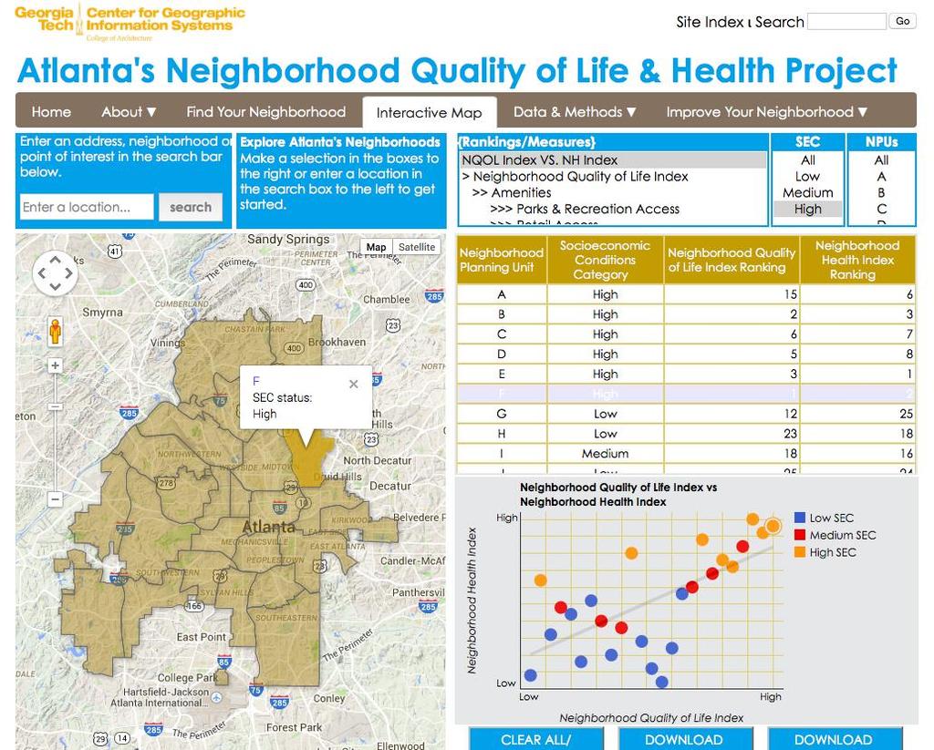
7 Comparing Neighborhoods with high Quality of Life & health Overlap matrix NPUs with high NH & NQoL SEC High QoL High Health Overlap High B, F, E F, E, N F, E Med M,O, W M, O, W M, O, W Low T, S, G V, T, Y T Source: authors.

8 Findings SES Status is not always predictive of areas with high quality of life and health parameters The central city neighborhoods seem to offer comprehensive amenities to achieve better QoL and health outcomes 8

9 Walk this Way: A New App to Find the Optimal Walking Route in the City of Atlanta
10 Walkability Factors Despite growing research on walkability, knowledge about paths and corridors that are conducive for walking is still largely unavailable Various travel surveys document that walkability factors and their impacts vary from person to person The built environment influences walking behavior

11 Walk Score 11

12 A Fancier version of Walkscore Available for New york city and Philadelphia


13 But when you want to know how to get from one point to another in a city by walking, what options do you have?? We wanted to develop a better option


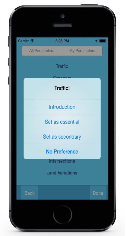
14 What is Walk this Way? A more comprehensive evaluation system for walkability User selection mechanism Optimal route identification for walkers
15 Walkability Attributes Walkability attributes were chosen based on extensive literature, that fall into below categories: 1) residential density; 2) business density; 3) land use mix diversity; 4) accessibility; 5) street connectivity; 6) crime safety; 7) traffic safety; 8) physical barriers; 9) aesthetics; and 10)pedestrian infrastructure.
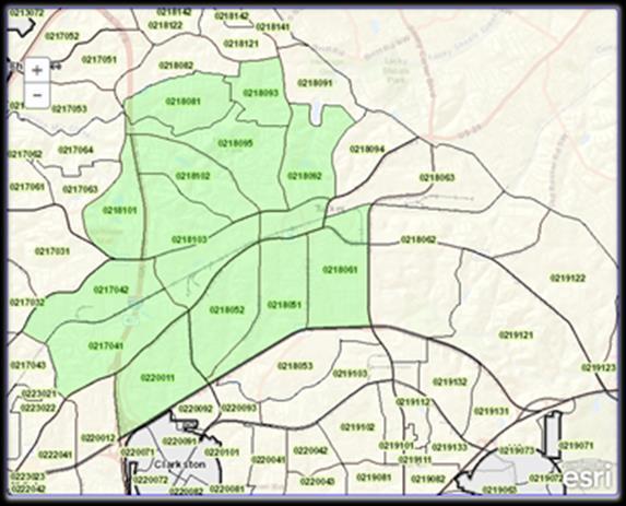
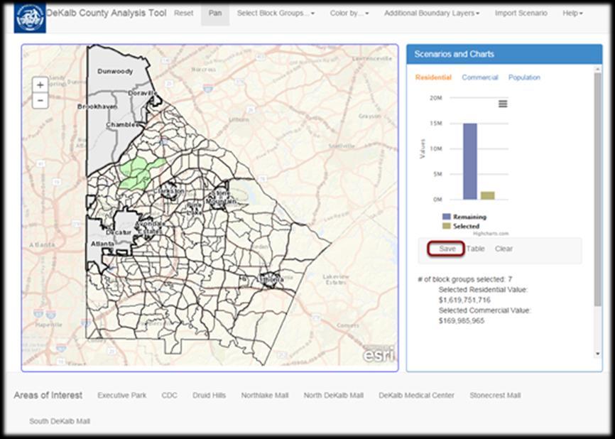
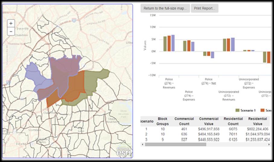
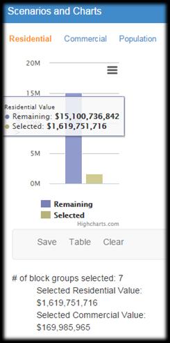
16 How does Walk this Way work? Walkability score calculation Attribute quantification 32 variables under 10 categories Weight estimation Analytical Hierarchy Process (AHP) Composite score calculation Walkability algorithm

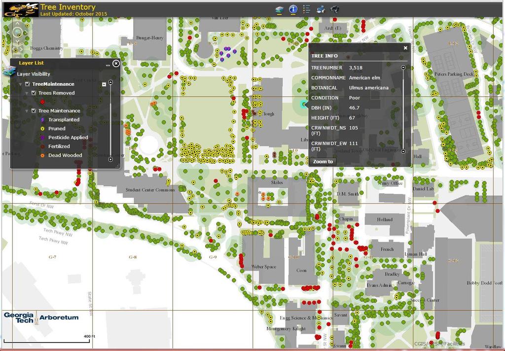
17 How does Walk this Way work? Weight estimation--ahp A pairwise importance comparison between variables Normalize each matrix element by the sum of elements in each column, calculate the sum for each row and then normalize the sum of the rows for the weights for each variable Calculate the consistency ratio of the selection to validate its consistency A simple AHP hierarchy
18 Composite walk score calculation WS j = D j n å i=1 ( VW ) i i Where WS j is the walkability score of the street segment j, D j is the length of the street segment j, n is the number of the attributes of walkability and Vi and Wi are the value and the weight for the attribute i, respectively.

19 How to use Walk this Way?
20 The Extensions of Walk This Way App for Location Intelligence and Geospatial Navigation (ALIGN!) Objective: Develop and evaluate the feasibility of a mobile app (ALIGN) to inform outdoor route planning by people aging with ambulatory disabilities who are experiencing comorbid functional losses. 20


")
21 Included Feedback on Route Conditions A Simpler Rating System (essential and secondary) Included Audio Feedback 21


22 User Interface Design 22


23 Fiscal Analysis of Municipal Annexation Block group level analysis: for Designated (271), Unincorporated (272), and Police (274) Funds

24 Sustainability - Urban Forestry Management
25 Pavement Management for Georgia s Local There are 159 counties and more then 700 cities in Georgia Governments (1) Current Local Maintenance & Improvement Grant (LMIG) program requires governments in Georgia to evaluate the condition of their roadway pavements to determine and prioritize roadway treatments that will produce the highest return on investment We developed a Computerized Pavement Condition Evaluation System for Counties and Cities (COPACES-CC)

26 Pavement Management for Georgia s Local Governments (2)


27 Roadway Asset Inventory Using Videolog Images and Computer Vision (1) Videolog images have been widely used for roadway asset (signs, guardrails, rumble strips, etc.) inventory in State Departments of Transportation (DOTs) Georgia DOT has spent more than $4 million and collected videolog images on 52,000 lane miles Visual inspection is very time consuming and labor intensive We are developing algorithms and applications to automate the data extraction process


28 Roadway Asset Inventory Using Videolog Images and Computer Vision (2)


29 ATLANTA TREE CANOPY STUDY 29


30 City Grid Divided the city into 6-acre (500 square feet) grid cells Aggregated tree cover across the city by grid cell Calculated cover percentages for each cell Cover percentages displayed in increments of ten Grid helps convey the distribution of tree cover across the city
")
 % UTC Population")


31 How do we compare? 18 cities with recent UTC studies Highest tree cover in cities with: Naturally forested regions (East Coast) Large parklands (Minneapolis, Washington DC) Large single-family lots in city limits (Charlotte) Should compare Atlanta against cities of similar: Geography Size Density City Size (Square Miles) % UTC Population Density (Persons/Sq Mi) Los Angeles Atlanta Charlotte Dallas Pittsburgh San NYC Francisco Wash Austin DC Ann Charlotte ArborMiami Austin Milwaukee Minneapolis Los Angeles Chicago Portland Denver Minneapolis Dallas Portland San Francisco Atlanta Portland Baltimore Baltimore Des Moines Des Moines Ann Arbor NYC Milwaukee Wash DC Atlanta Pittsburgh Miami Minneapolis Denver Charlotte San Los Francisco Angeles Miami Milwaukee Chicago Ann Arbor 0% 0 5,000 10% 10,000 20% 15,000 30% 20,000 40% 25,000 50% 30,000 60%


32 In Progress - Follow-up study using 2014 WorldView2 Satellite Imagery Next Steps
33 RESEARCH THRUST III: Web-based mapping, analysis, and routing applications


34 THANK YOU Visit us at Follow us on Twitter and Facebook
March 6, 2013 Tony Giarrusso, Rama Sivakumar Center for GIS, Georgia Institute of Technology
 March 6, 2013 Tony Giarrusso, Rama Sivakumar Center for GIS, Georgia Institute of Technology 33 46 35.74 N, 83 23 48.33 W Location: Georgia Institute of Technology, College of Architecture Established:1996
GIS Based Non-Motorized Transportation Planning APA Ohio Statewide Planning Conference. GIS Assisted Non-Motorized Transportation Planning
 The Purpose of GIS Assisted Network GIS Assisted Non-Motorized Transportation 2011 APA Ohio Statewide Conference Friday, 10:45 AM to Noon Focus on near-term projects wwwgreenwaycollabcom The purpose of
GIS Based Data Collection / Network Planning On a City Scale. Healthy Communities Active Transportation Workshop, Cleveland, Ohio May 10, 2011
 The Purpose of GIS Based Network Planning GIS Based Data Collection / Network Planning Healthy Communities Active Transportation Conference Tuesday, May 10, 2011 10:00 AM Norman Cox, LLA, ASLA. Ann Arbor,
CITY OF COCOA BEACH 2025 COMPREHENSIVE PLAN. Section VIII Mobility Element Goals, Objectives, and Policies
 CITY OF COCOA BEACH 2025 COMPREHENSIVE PLAN Section VIII Mobility Element Goals, Objectives, and Policies Adopted August 6, 2015 by Ordinance No. 1591 VIII MOBILITY ELEMENT Table of Contents Page Number
RURAL HIGHWAY SHOULDERS THAT ACCOMMODATE BICYCLE AND PEDESTRIAN USE (TxDOT Project ) June 7, Presented by: Karen Dixon, Ph.D., P.E.
 June 7, Presented by: Karen Dixon, Ph.D., P.E.") RURAL HIGHWAY SHOULDERS THAT ACCOMMODATE BICYCLE AND PEDESTRIAN USE (TxDOT Project 0-6840) June 7, 2016 Presented by: Karen Dixon, Ph.D., P.E., TTI Team: Kay Fitzpatrick, Raul Avelar, & Subasish Das Project
RURAL HIGHWAY SHOULDERS THAT ACCOMMODATE BICYCLE AND PEDESTRIAN USE (TxDOT Project 0-6840) June 7, 2016 Presented by: Karen Dixon, Ph.D., P.E., TTI Team: Kay Fitzpatrick, Raul Avelar, & Subasish Das Project
The Impact of Policy and Environmental Outcomes on Youth Physical Activity
 The Impact of Policy and Environmental Outcomes on Youth Physical Activity Childhood Obesity Conference, San Diego, CA June 30, 2011 Sandy Slater, PhD Assistant Professor, University of Illinois at Chicago,
DOWNTOWN MIAMI PEDESTRIAN PRIORITY ZONE
 DOWNTOWN MIAMI PEDESTRIAN PRIORITY ZONE AUGUST 6, 2013 DOWNTOWN MIAMI BY THE NUMBERS more than 200,000 people live, work, and play here every day is home to more than 1,000 events each year hosts more
National Housing Trends
 National Housing Trends 34% America s Choice of Best Long Term Investment 26% 17% 15% 6% Real Estate Stocks / Mutual Funds Gold Savings Accounts / CDs Bonds Gallup 2018 Housing Affordability 197 Index
Commonwealth Centre. at Westfields Corporate Center
 Commonwealth Centre at Westfields Corporate Center Sull y Rd Stonecroft B l v d Commonwealth Centre at Westfields Corporate Center Proposed Wegmans Retail 21 Acres Commonwealth Centre at Westfields Corporate
WALKNBIKE DRAFT PLAN NASHVILLE, TENNESSEE EXECUTIVE SUMMARY NASHVILLE, TENNESSEE
 NASHVILLE, TENNESSEE EXECUTIVE SUMMARY Executive Summary A world-class multi-modal transportation system is essential to a vibrant city and better quality of life. -Mayor Barry The WalknBike plan aims
Sidewalkology A Path to Solving San Antonio s Sidewalk Problem
 1 Sidewalkology A Path to Solving San Antonio s Sidewalk Problem Introduction This memorandum proposes the creation a Pedestrian Mobility Officer (PMO) position and/or an active transportation program
National Housing Trends
 National Housing Trends 34% America s Choice of Best Long Term Investment 26% 17% 15% 6% Real Estate Stocks / Mutual Funds Gold Savings Accounts / CDs Bonds Gallup 2018 Housing Affordability 197 Index
Ranking Walkable Urbanism in America s Largest Metros
 Ranking Walkable Urbanism in America s Largest Metros The Largest 30 Metros in the United States SHARE OF U.S. POPULATION SHARE OF U.S. GDP 54% 46% 42% 58% LARGEST 30 METROS REST OF U.S. The Old Dichotomy
Complete Streets Policies in Charlotte
 Complete Streets Policies in Charlotte Complete Streets Peer Exchange Baton Rouge, LA January 19, 2016 Norm Steinman, AICP Charlotte DOT Changing what we do to change what will happen 1. Inventory of Conditions
Impact of Bike Facilities on Residential Property Prices
 Portland State University PDXScholar TREC Friday Seminar Series Transportation Research and Education Center (TREC) 2-24-2017 Impact of Bike Facilities on Residential Property Prices Wei Shi Portland State
Fiscal Year Budget Overview
 Fiscal Year 2015-2016 Budget Overview Investing in Transportation for Today and Tomorrow Ed Reiskin Director of Transportation APRIL 1, 2014 San Francisco: great city, excellent transportation choices
May 12, 2016 Metro Potential Ballot Measure Issue Brief: Local Return
 Summary: Local return is an important revenue source for cities to maintain their local transportation infrastructure. Most cities use their local return to operate small bus systems and repave streets,
Sustainable Transportation Planning in the Portland Region
 Sustainable Transportation Planning in the Portland Region Jennifer Dill, Ph.D. Associate Professor School of Urban Studies & Planning jdill@pdx.edu http://web.pdx.edu/~jdill/ Outline Elements of a sustainable
National Housing Trends
 National Housing Trends 34% America s Choice of Best Long Term Investment 26% 17% 15% 6% Real Estate Stocks / Mutual Funds Gold Savings Accounts / CDs Bonds Gallup 2018 Housing Affordability 197 Index
Public Transport and Development: Making It Work
 Public Transport and Development: Making It Work Robert T. Dunphy Urban Land Institute World Bank Transport Forum 2006 March 28, 2006 Transportation Development Disconnect Now Few Then places w/o car Many
Walkable Communities and Adolescent Weight
 Walkable Communities and Adolescent Weight Sandy Slater, PhD Assistant Professor, University of Illinois at Chicago, School of Public Health Research Scientist, UIC Institute for Health Research and Policy
Analysis of Run-Off-Road Crashes in Relation to Roadway Features and Driver Behavior
 Analysis of Run-Off-Road Crashes in Relation to Roadway Features and Driver Behavior Ertan Örnek University of Wisconsin, Madison Traffic Operations Lab 141 NW Barstow Street Waukesha, WI 53187 ornek@wisc.edu
THE MOST INFORMATIVE EVENT COVERING REAL ESTATE INVESTMENTS
 THE MOST INFORMATIVE EVENT COVERING REAL ESTATE INVESTMENTS 2014 U.S. Economic, Capital Markets, and Retail Market Overview and Outlook Retail Trends 2014 U.S. Economic Overview and Outlook Total Employment
National Housing Trends
 National Housing Trends 34% America s Choice of Best Long Term Investment 26% 17% 15% 6% Real Estate Stocks / Mutual Funds Gold Savings Accounts / CDs Bonds Gallup 2018 Home Sales in thousands 2017 2018P
UNDERSTANDING WALKING NETWORKS TO ENABLE SMARTER CHOICES IN TRANSPORT PLANNING IN DUNDEE. Gillian Iversen Atkins
 UNDERSTANDING WALKING NETWORKS TO ENABLE SMARTER CHOICES IN TRANSPORT PLANNING IN DUNDEE Gillian Iversen Atkins 1. INTRODUCTION 1.1. Smarter Choices, Smarter Places The Smarter Choices agenda encourages
Complete Street Analysis of a Road Diet: Orange Grove Boulevard, Pasadena, CA
 Complete Street Analysis of a Road Diet: Orange Grove Boulevard, Pasadena, CA Aaron Elias, Bill Cisco Abstract As part of evaluating the feasibility of a road diet on Orange Grove Boulevard in Pasadena,
SFMTA Annual Parking Rates & Policies Survey
 SFMTA Annual Parking Rates & Policies Survey December 2011 2011 Parking Rates and Policies Survey/ 1 Parking rates and policies survey The purpose of the survey is to track changes over time in other cities
Pedestrian Project List and Prioritization
 To: Kyle Wagenschutz, City of Memphis CC: From: Anne Conlon and John Cock, Alta Planning + Design Date: December, 2014 Re: Project List Development (Task 3.1-3.2) and Project List Prioritization (Task
Carmel, Indiana Illinois Street and 126th Street Westfield Boulevard and 96th Street Arts and Design District RAB
 Sustainability Benefits Of Network Wide Roundabout Use Case Study of Carmel, Indiana Presented By: Michael McBride PE Carmel City Engineer Carmel, Indiana Carmel, Indiana 1996 Carmel, Indiana Population
Methodology for Linking Greenways and Trails with Public Transportation in Florida
 Methodology for Linking Greenways and Trails with Public Transportation in Florida Sara Hendricks, Senior Research Associate Center for Urban Transportation Research, University of South Florida CUTR Webcast,
Presentation Summary Why Use GIS for Ped Planning? What Tools are Most Useful? How Can They be Applied? Pedestrian GIS Tools What are they good for?
 1 2 Pedestrian GIS Tools What are they good for? Pro Walk / Pro Bike 2006 Presentation Summary Why Use GIS for Ped Planning? What Tools are Most Useful? How Can They be Applied? Matt Haynes Fehr & Peers
METRO RTA TRANSIT MASTER PLAN. May 25-26, 2011
 METRO RTA TRANSIT MASTER PLAN May 25-26, 2011 WHAT IS THE TRANSIT MASTER PLAN? A twenty-year plan for METRO RTA What will METRO look like in 2031? 1 TRANSIT TECHNOLOGIES 2 TRANSIT TECHNOLOGIES Transit
Introduction. Mode Choice and Urban Form. The Transportation Planner s Approach. The problem
 Introduction The table below shows transit s share in the urban US (all trip purposes) and the 10 urban areas where it is most popular (2008 data): Mode Choice and Urban Form Philip A. Viton April 4, 2014
Appendix C. Corridor Spacing Research
 Appendix C. Corridor Spacing Research Task 3 of the Twin Cities Bicycle Study called for the development of bicycle corridor spacing guidelines. This section summarizes research of the spacing of planned
City of West Des Moines PAVEMENT MANAGEMENT SYSTEM
 City of West Des Moines PAVEMENT MANAGEMENT SYSTEM 12/11/2018 Municipal Street Seminar (11-14-2018) JEFF NASH 1 City Background Information: - West Des Moines current census Population is around 66,000
GEOGRAPHY LESSON 1: PRE-VISIT - SAFE AT HOME LOCATION, PLACE AND BASEBALL BASEBALL COAST TO COAST HOUSTON ASTROS IN PARTNER WITH THE NBHOF
 PRE-VISIT - SAFE AT HOME LOCATION, PLACE AND BASEBALL OBJECTIVE: Students will be able to: Define location and place, two of the five themes of geography. Give reasons for the use of latitude and longitude.
Carol Tomé CFO and Executive Vice President, Corporate Services
 Carol Tomé CFO and Executive Vice President, Corporate Services Financial Overview December 6, 2017 1 Discussion Overview Fiscal 2017 Financial Guidance Our View of the Economy and State of the U.S. Housing
The Walkability Indicator. The Walkability Indicator: A Case Study of the City of Boulder, CO. College of Architecture and Planning
 1 : A Case Study of the City of Boulder, CO College of Architecture and Planning University of Colorado Author Note: Daryoosh Ardalan, Urban Regional Planning, College of Architecture and Planning, University
Contributions of neighborhood street scale elements to physical activity in Mexican school children
 Contributions of neighborhood street scale elements to physical activity in Mexican school children Rebecca E. Lee, Erica G. Soltero, Alejandra Jauregui, Scherezade K. Mama, Simon Barquera, Edtna Jauregui,
Bike Score: Applying Research to Build Web-Based Tools to Promote Cycling
 Bike Score: Applying Research to Build Web-Based Tools to Promote Cycling Meghan Winters Faculty of Health Sciences Simon Fraser University mwinters@sfu.ca Matt Lerner, Kay Teschke, Mike Brauer Velo-City
Vision: Traditional hamlet with an attractive business/pedestrian friendly main street connected to adjacent walkable neighborhoods
 N D. Focus Area II Vision: Traditional hamlet with an attractive business/pedestrian friendly main street connected to adjacent walkable neighborhoods Transit Road Focus Area II is located in the Hamlet
Portland Bike Share PORTLANDOREGON. GOV/TRANSPORTATION 2
 Portland Bike Share PORTLANDOREGON. GOV/TRANSPORTATION 2 Our Partners PORTLANDOREGON. GOV/TRANSPORTATION 3 600 Bikes 30 Stations Service area will cover entire central city PORTLANDOREGON. GOV/TRANSPORTATION
Click to edit Master title style
 Click to edit Master title style Dallas July 27, 2017 7/27/2017 1 1 Click to edit Master title style 7/27/2017 2 2 Click to edit Master title style 7/27/2017 3 3 Click to edit Master title style TAP Software
U.S. Economic and Apartment Market Overview and Outlook. July 15, 2014
 2014 U.S. Economic and Apartment Market Overview and Outlook July 15, 2014 U.S. Economic Overview U.S. GDP Growth Persistent Despite 1Q Polar Vortex Annualized Quarterly Percent Change 10% 5% 0% -5% -10%
A GIS APPROACH TO EVALUATE BUS STOP ACCESSIBILITY
 Advanced OR and AI Methods in Transportation A GIS APPROACH TO EVALUATE BUS STOP ACCESSIBILITY Giuseppe SALVO 1, Simona SABATINI 2 Abstract. This paper proposes a methodology to assess public transportation
Sacramento Grid 2.0. The Downtown Transportation Study
 Sacramento Grid 2.0 The Downtown Transportation Study April 20, 2016 The Grid 4.25 square miles Street grid defined at birth of City Lettered and numbered streets spaced every 400 ft East-west alleys halfway
Mayor s Pedestrian Advisory Council. Wednesday, November 8 th
 Mayor s Pedestrian Advisory Council Wednesday, November 8 th Year-to-Date Pedestrian Fatalities, 2017 (CPD): 39 Year-to-Date Pedestrian Fatalities, 2016 (CPD): 38 Year-to-Date Pedestrian Fatalities, 2010-2014
Transit-Driven Complete Streets
 Questions: Type questions into the box at bottom of webinar panel. Panelists for today s webinar: Nimotalai Azeez, Program Associate with the National Complete Streets Coalition Rich Weaver, Director of
ARLINGTON COUNTY, VIRGINIA
 ARLINGTON COUNTY, VIRGINIA County Board Agenda Item Meeting of October 15, 2016 DATE: October 7, 2016 SUBJECT: Adoption of amendments to the Master Transportation Plan (MTP) to create a new Pedestrian
Living Streets Policy
 Living Streets Policy Introduction Living streets balance the needs of motorists, bicyclists, pedestrians and transit riders in ways that promote safety and convenience, enhance community identity, create
o n - m o t o r i z e d transportation is an overlooked element that can greatly enhance the overall quality of life for the community s residents.
 N o n - m o t o r i z e d transportation is an overlooked element that can greatly enhance the overall quality of life for the community s residents. 84 Transportation CHAPTER 11 INTRODUCTION Transportation
WHAT IS BRT? Jack M. Gonsalves, PE, Parsons Brinckerhoff, Inc. February 22, 2012
 WHAT IS BRT? Jack M. Gonsalves, PE, Parsons Brinckerhoff, Inc. February 22, 2012 What is Bus Rapid Transit (BRT)? A flexible, high performance rapid transit mode that combines a variety of physical, operating,
PEDESTRIAN ACTION PLAN
 ATTACHMENT 2 CITY OF SANTA MONICA PEDESTRIAN ACTION PLAN CITY OF SANTA MONICA PEDESTRIAN ACTION PLAN This page intentionally left blank EXECUTIVE SUMMARY CHAPTER 1 EXECUTIVE SUMMARY Setting the Stage
LANCASTER CITY BICYCLE NETWORK
 LANCASTER CITY BICYCLE NETWORK Downtown Merchants Meeting Wednesday, July 19, 2017 http://www.lancasteratp. DOWNTOWN WALKABILITY ANALYSIS What changes can be made, in the least amount of time, and for
Evaluating Road Departure Crashes Using Naturalistic Driving Study Data
 Evaluating Road Departure Crashes Using Naturalistic Driving Study Data Strategic Highway Research Program 2 Transportation Research Board Third Safety Research Symposium July 17 & 18, 2008 Research Team:
Proposed. City of Grand Junction Complete Streets Policy. Exhibit 10
 Proposed City of Grand Junction Complete Streets Policy Exhibit 10 1 City of Grand Junction Complete Streets Policy Vision: The Complete Streets Vision is to develop a safe, efficient, and reliable travel
Frequently asked questions about how the Transport Walkability Index was calculated are answered below.
 Transport Walkability Index The Transport Walkability Index is a relative indicator of how well the built environment in different areas supports walking for transport. The index is frequently used in
Vision Zero High Injury Network Methodology
 Vision Zero High Injury Network Methodology DATA SETS USED: 1. Reportable crashes in Philadelphia from 2012-2016, available as open data through PennDOT 2. Street Centerline geographic layer, maintained
Clackamas County Comprehensive Plan
 ROADWAYS The County s road system permits the movement of goods and people between communities and regions, using any of a variety of modes of travel. Roads provide access to virtually all property. They
Look Twice! Inventorying Pavement Markings for the City of Austin. Our story of how we accomplished data inventory of our city crosswalks.
 Look Twice! Inventorying Pavement Markings for the City of Austin. Our story of how we accomplished data inventory of our city crosswalks. City of Austin Austin Transportation Department Signs & Markings
Hennepin County Bicycle and Pedestrian Planning
 Hennepin County Bicycle and Pedestrian Planning 1 Value of bicycle and sidewalk systems Safety Livability Mobility Health Personal Finances Economic Sustainability Clean Air Recreation Parking and congestion
Development of Analytical Tools to Evaluate Road Departure Crashes Using Naturalistic Driving Study Data
 Development of Analytical Tools to Evaluate Road Departure Crashes Using Naturalistic Driving Study Data Safety Research Symposium Strategic Highway Research Program 2 Transportation Research Board July
ADA Transition Plan. City of Gainesville FY19-FY28. Date: November 5, Prepared by: City Of Gainesville Department of Mobility
 ADA Transition Plan FY19-FY28 Date: November 5, 2018 Prepared by: City Of Gainesville Department of Mobility 1.0 INTRODUCTION 1.1 BACKGROUND The federal statute known as the Americans with Disabilities
Planning Suburban Bike Networks
 Planning Suburban Bike Networks Stacey Meekins, AICP 28 October, 2015 Bikeway design guidance Different Cyclists Have Different Needs No interest 33% Strong and Fearless 1% Enthused and Confident 7% Interested,
Ann Arbor Downtown Street Plan
 1 Ann Arbor Downtown Street Plan Public Workshop #1 We know that. 2 Public right-of-way (streets, sidewalks, and alleys) make up 30% of the total District area of downtown. Streets need to provide mobility
A Survey of Planning, Design, and Education for Bikeways and Bus Routes on Urban Streets
 A Survey of Planning, Design, and Education for Bikeways and Bus Routes on Urban Streets, Community & Economic Development Agency, Transportation Services Division (510) 238-3983 bikeped@oaklandnet.com
ADOT Statewide Bicycle and Pedestrian Program Summary of Phase IV Activities APPENDIX B PEDESTRIAN DEMAND INDEX
 ADOT Statewide Bicycle and Pedestrian Program Summary of Activities APPENDIX B PEDESTRIAN DEMAND INDEX May 24, 2009 Pedestrian Demand Index for State Highway Facilities Revised: May 29, 2007 Introduction
The Brookings Institution Metropolitan Policy Program
 The Brookings Institution Metropolitan Policy Program The Structural Shift in Building The Built Environment The Next American Dream for the 21 st Century Economy The Brookings Institution Metropolitan
In station areas, new pedestrian links can increase network connectivity and provide direct access to stations.
 The Last Mile Planning for Pedestrians Planning around stations will put pedestrians first. Making walking to stations safe and easy is important; walking will be a part of every rapid transit Accessible
Building Community Partnerships for Mobility:
 Building Community Partnerships for Mobility: San Francisco 2008 Presented by: Cynthia Hoyle, AICP Transportation Planning Consultant Champaign-Urbana Mass Transit District Background The Heartland Champaign-Urbana,
INTRODUCTION THOROUGHFARE SYSTEM CLASSIFICATIONS
 INTRODUCTION The thoroughfare plan will assist public officials in the development of a specialized system for efficient and safe movement of vehicular traffic while minimizing potential conflicts with
Public Workshop #2. September 14, 2016
 Public Workshop #2 September 14, 2016 Agenda Welcome Project Overview Where We Have Been Alternatives for State Street Land Use Street Design Next Steps 2 Project Overview Create a Vibrant State Street
POLICY AGENDA For Elder Pedestrian Safety
 POLICY AGENDA For Elder Pedestrian Safety Older adults and people with disabilities often have mobility, cognitive, and sensory limitations that affect their behavior as pedestrians and place them at risk
Part A: Changes in Distance between Major League Baseball Franchises and their Triple-A Affiliates
 Five Themes of Geography: Movement Major and Minor League Baseball Team Affiliations, 1998 & 2011 Ezra Zeitler University of Wisconsin-Eau Claire Department of Geography & Anthropology Purpose: This exercise
Multimodal Transportation Plan
 Multimodal Transportation Plan The Multimodal Transportation Plan will accommodate MILLENIALS ARE DRIVING LESS. WE CANNOT BUILD OUR WAY all modes of transportation by keeping pedestrians, OUT OF CONGESTION.
Chapter 5 DATA COLLECTION FOR TRANSPORTATION SAFETY STUDIES
 Chapter 5 DATA COLLECTION FOR TRANSPORTATION SAFETY STUDIES 5.1 PURPOSE (1) The purpose of the Traffic Safety Studies chapter is to provide guidance on the data collection requirements for conducting a
Complete Streets 101: The Basics
 Complete Streets 101: The Basics Michigan Municipal League - Capital Conference March 21, 2017 Chip Smith, AICP - Senior Planner - Wade Trim Inc. and City Council member City of Ann Arbor 2017 MML Capital
Corridor Vision Workshop Summary James Madison Elementary February 22,2018
 Corridor Vision Workshop Summary James Madison Elementary February 22,2018 WHY DEVELOP THIS STUDY? Ogden City is planning for better connectivity and access to jobs and housing. Working with area partners,
/ ARLINGTON COUNTY, VIRGINIA
 / ARLINGTON COUNTY, VIRGINIA County Board Agenda Item Meeting of September 24, 2016 DATE: August 11, 2016 SUBJECT: Amendment of the Master Transportation Plan (MTP) Streets Element to include new local
Planning for Better Bikeway Maintenance Center for Transportation Studies Research Conference
 Planning for Better Bikeway Maintenance Center for Transportation Studies Research Conference 11.2.2017 Jordan Kocak Shaun Lopez-Murphy @tooledesign Photo Credit: City of Rochester, MN and City of Brooklyn
LEED Pilot Credit Library
 Pilot Credit 13: Bicycle Network, Storage, and Shower Rooms Applicable Rating Systems >> Requirements >> Submittals >> Additional Questions >> Background Information >> Changes >> Applicable Rating Systems
Chapter 4 Traffic Analysis
 Chapter 4 Traffic Analysis PURPOSE The traffic analysis component of the K-68 Corridor Management Plan incorporates information on the existing transportation network, such as traffic volumes and intersection
Bicycle and Pedestrian Planning in a Historically Car-Centric Culture: A Focus on Connectivity, Safety, & Accessibility
 Bicycle and Pedestrian Planning in a Historically Car-Centric Culture: A Focus on Connectivity, Safety, & Accessibility Kate Horton and Zylavian Watley Transportation Planners Memphis MPO Date: October
MOBILITY RESULTS AREA. Budgeting For Outcomes Council Presentation January 12, 2007
 MOBILITY RESULTS AREA Budgeting For Outcomes Council Presentation January 12, 2007 Mobility Results Team Members 2 Hammond Perot, OED, Co-Team Leader Bonnie Meeder, DEV (returning), Co-Team Leader Peer
Incorporating Health in Regional Transportation Planning
 Mayor Karl Dean, Chairman Incorporating Health in Regional Transportation Planning Leslie A. Meehan, AICP Center TRT Intervention Webinar January 29, 2013 Objectives for Today Background About the Nashville
Complete Streets Successes, Opportunities, and Challenges
 Complete Streets Successes, Opportunities, and Challenges Juliet Walker, Transportation Planner, City of Portsmouth Rob Houseman, Director of Planning and Development, Town of Wolfeboro Chris Parker, Director
The City and the Dynamics of Inequality. John Mollenkopf, City University of New York Robert Sampson, Harvard University Wesley G.
 The City and the Dynamics of Inequality John Mollenkopf, City University of New York Robert Sampson, Harvard University Wesley G. Skogan, IPR Introductory Comments 1 brief description of crime research
Non-motorized Transportation Planning Resource Book Mayor s Task Force on Walking and Bicycling City of Lansing, Michigan Spring 2007 pg.
 Non-motorized Transportation Planning Resource Book pg. 105 of 158 Non-motorized Transportation Planning Resource Book pg. 106 of 158 Non-motorized Transportation Planning Resource Book pg. 107 of 158
Developing a Bike/Pedestrian Plan Using ArcInfo and Public Participation Rob Shumowsky, Madison County Council of Governments
 Developing a Bike/Pedestrian Plan Using ArcInfo and Public Participation Rob Shumowsky, Madison County Council of Governments Abstract: The Madison County Council of Governments is creating a bike/pedestrian
Regional Bicycle Barriers Study
 Regional Bicycle Barriers Study Executive Summary Background and Purpose The 2040 Transportation Policy Plan (TPP) sets policies for planning and investment direction in the transportation system in the
Bicycle Demand Forecasting for Bloomingdale Trail in Chicago
 Bicycle Demand Forecasting for Bloomingdale Trail in Chicago Corresponding Author: Zuxuan Deng Arup Water Street, New York, NY 000 zuxuan.deng@arup.com Phone:.. Fax:..0 Matthew Sheren Arup Water Street,
Neighborhood Vibrancy:
 Neighborhood Vibrancy: Think Small in a Big Way Ed McMahon Urban Land Institute September 17, 2015 Walkability? Walkability is the degree to which we find it pleasurable to walk in particular locales.
100 Most Congested Roadways in Texas
 100 Most Congested Roadways in Texas 2017 EXECUTIVE SUMMARY In response to increased roadway congestion throughout the state, in 2009 the Texas Legislature mandated that the Texas Department of Transportation
WALKscope Data Challenge Tip Sheet
 WALKscope Data Challenge Tip Sheet Help us map where sidewalks end and win prizes for your neighborhood! WalkDenver & Denver Environmental Health (DEH) s Community Active Living Coalition (CALC) are proud
About the Active Transportation Alliance
 About the Active Transportation Alliance Chicagoland s voice for better biking, walking and transit Founded 1985 7,000 members, ~33 full time staff Serve Chicago metro region 1 More Cars, More Driving
Approaches. Livable Neighborhood Design. Examples. Traditional neighborhood development. CE 594 University of Wisconsin- Milwaukee
 Approaches Livable Neighborhood Design CE 594 University of Wisconsin- Milwaukee Traditional neighborhood design (TND), new urbanism, transit friendly design, transit oriented development and walkable
MASTER BICYCLE AND PEDESTRIAN PLAN
 VILLAGE OF NORTHBROOK MASTER BICYCLE AND PEDESTRIAN PLAN DRAFT PLAN OPEN HOUSE May 2, 2018 AGENDA 1. Community Engagement 2. Vision and Goals 3. General Structure of Plan 4. Recommendations Overview 5.
How Policy Drives Mode Choice in Children s Transportation to School
 How Policy Drives Mode Choice in Children s Transportation to School Physical Activity through Active Transportation Ruth L. Steiner 2011 Technical Conference and Exhibit Lake Buena Vista, FL April 3-6,
A Comparison of Highway Construction Costs in the Midwest and Nationally
 A Comparison of Highway Construction Costs in the Midwest and Nationally March 20, 2018 Mary Craighead, AICP 1 INTRODUCTION State Departments of Transportation play a significant role in the construction
How to Develop a Pedestrian Safety Action Plan
 How to Develop a Pedestrian Safety Action Plan Course Introduction Presented by: Peter Eun FHWA RC Safety Engineer Ryan Snyder President, Ryan Snyder Associates, LLC Paul Zykofsky Director, Land Use and