Dubbo Gully and Ten Mile Hollow Circuit (via Clares Bridge)
|
|
|
- Cecilia Summers
- 5 years ago
- Views:
Transcription


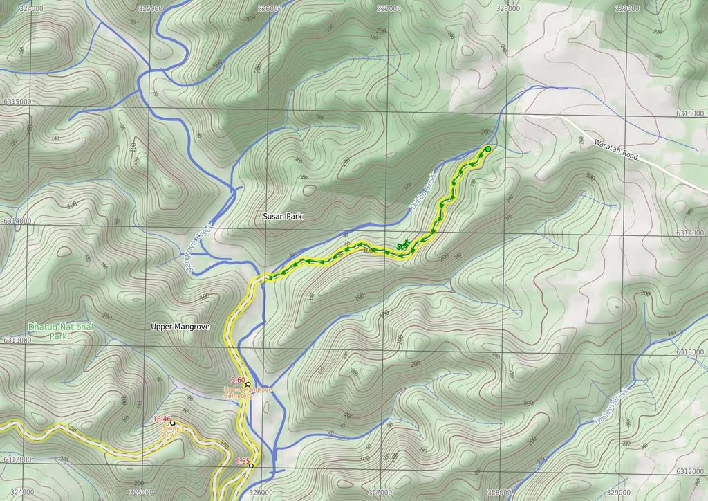
1 Dubbo Gully and Ten Mile Hollow Circuit (via Clares Bridge) 2 Days Hard track 24.3 km Circuit m This two day (or ten hour) walk follows several historic roads, now closed to traffic. Starting with a walk down to Dubbo Gully and past an old cemetery, you will then explore some old farms before coming to Simpsons Track. Here, head up the hill to come to the Ten Mile Hollow Campsite. The next day you will follow the Old Great North Road to Clare's Bridge (second oldest bridge on mainland Australia). A bit further along the Old Great North Road, you then head down Donny's track and return to the start via Dubbo Gully. A great way to explore the history and beauty of the area. 226m 7m Dharug National Park Maps, text & images are copyright wildwalks.com Thanks to OSM, NASA and others for data used to generate some map layers.

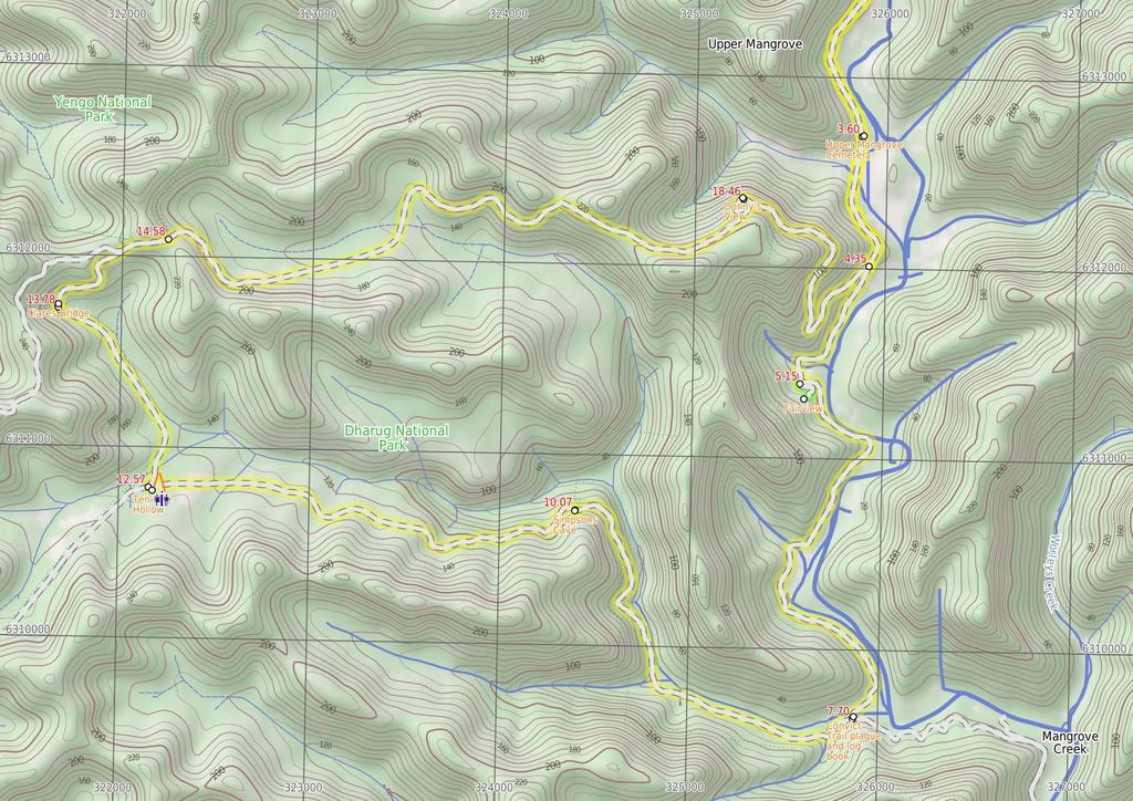
2 Upper Mangrove Cemetery Before You walk The Upper Mangrove Cemetery is on the western bank of Mangrove Creek, near the junction with Newmans Creek. The cemetery was part of St Thomas' Church of England, however the church building was destroyed in the 2002 bushfires. Exploring the cemetery gives a glimpse into the history of the valley. You will find the stone remembering Alfred and Amanda Andrews who built 'Fairview' in 1922 and read of the loss of Leslie Starkey's parents in On the other side of the road, up the hill, is the remains of of the old St Thomas' Church building. More info. Bushwalking is fun and a wonderful way to enjoy our natural places. Sometimes things go bad, with a bit of planning you can increase your chance of having an ejoyable and safer walk. Before setting off on your walk check Fairview Fairview (550 Ten Mile Hollow Rd, Mangrove Creek) is a property with a homestead, built in 1922 by Alfred Andrews. The homestead and adjoining slab hut are now fenced to protect them, however the large corrugated iron shed on the south side is still open. The homestead was once a popular rest area for people traveling the North Road, via the Simpson track. The home was privately owned until 1973 when Gosford City Council acquired the land to protect the catchment area. The home was rented until 2002, when the tenants moved due to the threat of bushfires. The building is now in poor condition and the 'Friends of Fairview' are exploring ways to save the building and restore the history of the valley. Save Fairview More info. Convict Trail plaque and log book In a large clearing at the end of of Ten Mile Hollow Creek is a boulder with a 'Convict Trail' plaque. The inscription provides information on the area and the historic old Great North Road and Simpson's Track. Behind the boulder is a metal box housing a log book, waiting for your entry. Simpsons Cave Simpsons Cave is an informal name given to a sandstone overhang on the Simpson Track, about 2.5km east of the junction with the Old Great North Road. The cave is perched high on the side of the old road and looks north over Ten Mile Hollow valley. The cave has an outward sloping floor and is best viewed from the track. 1) Weather Forecast (BOM Hunter District) 2) Fire Dangers (Greater Sydney Region) 3) Park Alerts (Dharug National Park, Yengo National Park) 4) Research the walk to check your party has the skills, fitness and equipment required 5) Agree to stay as a group and not leave anyone to walk solo Think before you TREK The 'Think before you TREK' program developed by NSW Police & NPWS promotes the benefits of planning ahead for your bushwalking trip by using an easy to remember acronym: adequate supplies of food, water, navigation and first T Take aid equipment. your planned route and tell friends and family when R Register you expect to return. beacon (PLB's) should be carried on walks with E Emergency significant gaps in mobile coverage (check terrain profile). to your planned route and follow the map and walking K Keep trails. Topo Maps The maps provided on wildwalks are helpful, but there are times where you may need maps covering a broader area. Maps that cover this walk include; 1: Map Series:91313N MANGROVE 1: Map Series:9131 GOSFORD Grade This walk has been graded using the AS The overall grade of the walk is dertermined by the highest classification along the whole track. 4 Grade 4/6 Hard track Length 24.3 km Circuit Time 2 Days Quality of track Formed track, with some branches and other obstacles (3/6) Signs Directional signs along the way (3/6) Experience Required Some bushwalking experience recommended (3/6) Weather Weather generally has little impact on safety (1/6) Infrastructure Limited facilities, not all cliffs are fenced (3/6)
3 Are you ready to have fun? Please ensure you and your group are well prepared and equipped for all possible hazards and delays. Check park closures, weather information and Fire Danger Rating before setting out. Optional side trips and alternate routes noted are not included in this walks overall grade, length or time estimate. Please allow extra time for resting and exploring areas of interest. The authors, staff and owners of wildwalks take care in preparing this information but will not accept responsibility for any inconvenience, loss or injury you may experience. Please take care, have fun - Happy Walking. Getting there Traveling by car is the only practical way to get to Dubbo Gully Rd car park (gps: , ). Car: There is free parking available. This is a circuit, so you will finish back at the start. Find up to date and more information inlcuding; travel directions, weather, park closures and walker feedback at 0 Dubbo Gully Rd car park (3.6 km 1 hr 24 mins) From the car park (a small clearing about 450m along the unsignposted Dubbo Gully Rd. Dubbo Gully Rd is found a by turning left off Waratah Rd when it becomes unsealed, about 4km from Mangrove Mountain shops), the walk follows the management trail down the hill and soon passes around a gate. There are some beautiful rock overhangs and scenery along this section of the walk. The walk continues to wind down the hill for a long while and eventually reaches the signposted intersection with the 'Upper Mangrove Creek Rd' (just before a bridge). Continue straight: From the intersection, the walk follows the management trail (now Ten Mile Hollow Rd) and immediately crosses the longer bridge (leaving the shorter bridge with a gate to the right). The walk meanders along the trail for some time, passing an old '134' sign to the right and a few old orange trees to the left. Soon after passing under some high voltage power lines, the walk arrives at a historic cemetery. 3.6 Upper Mangrove Cemetery The Upper Mangrove Cemetery is on the western bank of Mangrove Creek, near the junction with Newmans Creek. The cemetery was part of St Thomas' Church of England, however the church building was destroyed in the 2002 bushfires. Exploring the cemetery gives a glimpse into the history of the valley. You will find the stone remembering Alfred and Amanda Andrews who built 'Fairview' in 1922 and read of the loss of Leslie Starkey's parents in On the other side of the road, up the hill, is the remains of of the old St Thomas' Church building. More info. 3.6 Upper Mangrove cemetery (740 m 15 mins) Continue straight: From the cemetery, the walk follows the management trail down the hill, leaving the cemetery to the left. The trail meanders along the valley for some time, passing a swampy area to the right and a large grassy clearing to the left. A short distance later, the walk reaches the signposted intersection with 'Donny's Track' Int of Ten Mile Hollow Rd and Donnys track (810 m 15 mins) Continue straight: From the intersection, the walk follows the management trail down the hill. The walk soon passes around a gate and continues a little further, passing around a swampy area to the left and immediately arriving at an intersection near a gate. The trail behind the gate leads to an old abandoned house and shed, which could provide some shelter Optional sidetrip to Fairview Homestead (120 m 3 mins) Continue straight: From the intersection, the walk passes around the gate and follows the management trail steeply up the hill. The trail soon arrives at an old, abandoned house. At the end of this side trip, retrace your steps back to the main walk then Turn right Fairview Fairview (550 Ten Mile Hollow Rd, Mangrove Creek) is a property with a homestead, built in 1922 by Alfred Andrews. The homestead and adjoining slab hut are now fenced to protect them, however the large corrugated iron shed on the south side is still open. The homestead was once a popular rest area for people traveling the North Road, via the Simpson track. The home was privately owned until 1973 when Gosford City Council acquired the land to protect the catchment area. The home was rented until 2002, when the tenants moved due to the threat of bushfires. The building is now in poor condition and the 'Friends of Fairview' are exploring ways to save the building and restore the history of the valley. Save Fairview More info Int below Fairview Homestead (2.5 km 47 mins) Turn left : From the intersection, the walk follows the management trail, leaving the gate to the right and keeping the swampy area to the left. After passing a grassy clearing and old trail to the left, the walk soon passes a 'Heritage Road Wall AND Culvert Protection' signpost. Allow some time to look at the old road retaining wall sections along here. The walk continues to meander close to the creek, passing amongst some nice trees and some large clearings. The walk then passes a smaller clearing, to the left, with a padlocked steel 'Monitoring Well'. Soon after this, the walk passes through another long clearing with the remains of an old wooden fenced cattle yard. The walk then crosses a small creek and passes through to another clearing, passing a couple of boulders on the left with 'Convict Trail' information signs and a visitors book, to arrive at the intersection with the Simpson track, marked with a National Parks walkers signpost. 7.7 Convict Trail plaque and log book In a large clearing at the end of of Ten Mile Hollow Creek is a boulder with a 'Convict Trail' plaque. The inscription provides information on the area and the historic old Great North Road and Simpson's Track. Behind the boulder is a metal box housing a log book, waiting for your entry. 7.7 Int of Ten Mile Hollow Rd and Simpsons track (2.4 km 49 mins) Turn right: From the intersection, this walk follows the NPWS arrow post west along the flat trail (Simpsons Track), further up the Ten Mile Hollow gully. The trail leaves the large clearing and soon passes a series of smaller clearings. After crossing a few creeks, the trail enters the thicker bush. About 1.7km from the large clearing, the trail enters the signposted 'Dharug National Park'. From here, the walk continues up the trail and, after about 750m and a distinct change in vegetation, the trail comes to the base of a large cliff and a couple of caves, up the hill on the left Simpsons Cave Simpsons Cave is an informal name given to a sandstone overhang on the Simpson Track, about 2.5km east of the junction with the Old Great North Road. The cave is perched high on the side of the old road and looks north over Ten Mile Hollow valley. The cave has an outward sloping floor and is best viewed from the track Simpsons Cave (2.5 km 47 mins) Continue straight: From the caves, this walk follows the management trail (Simpsons Track) up the hill keeping the valley to the right. After winding up the hill for quiet some time, the trail leads under some hightension power lines in a large clearing. About 200m past this clearing, the main trail comes to a signposted intersection with the Old Great North Road at Ten Mile Hollow and a 'Simpsons Track' sign pointing back along the trail Ten Mile Hollow This large, open campsite is found next to the Old Great North Road, at the top of the Simpson Track. The campsite is great for people walking or cycling in the area. There is fairly new hybrid toilet, a few fire circles and plenty of places to pitch some tents. There is a water tank next to the toilet - if this is empty, there is sometimes water in Ten Mile Hollow creek a short distance north along the OGNR (otherwise the Wat Buddha Dhamma, about 600m south along the OGNR, provide a water tank for visitors). Treat water before drinking. The area was formally a stockade (a camp) for the convicts who built the road in c Later the area was named 'Snodgrass Valley' and plans to build a town were developed, neither the name nor the town proved popular (even at 2 pounds an acre). Solomon Wiseman (of Wisemans Ferry fame) was given 100 acres to build an inn, however it is not clear if the inn was ever built. More info End of day 1 This is the planned overnight stay for the end of day 1, happy camping.
. The walk crosses the bridge (and Ten Mile Hollow Creek) and heads around the gate.")
4 12.57 Ten Mile Hollow (1.2 km 22 mins) Turn right: From Ten Mile Hollow, this walk follows the 'Clares Bridge' sign along the OGNR, as it soon bends to the left. The trail narrows and comes to an old bridge (with a timber base). The walk crosses the bridge (and Ten Mile Hollow Creek) and heads around the gate. The walk follows the overgrown management trail through the bush for a while, coming to a white wooden barricade. Heading around the barricade, the walk comes to a clearing and signpost just before Clare's Bridge Clares Bridge Clare's Bridge, on the Old Great North Road, is about 1km north of Ten Mile Hollow camping area. This, and a number of other bridges, were built during the construction of the old road. Clare's Bridge is the most visually spectacular of the bridges. The second oldest bridge on mainland Australia (The oldest being Thomas James Bridge), it is built of sandstone blocks and has a wonderful, sweeping retaining wall. The sweeping design gives full view of the craftsmanship to those passing by. Much work has been done by NPWS and Gosford Council to restore the bridge. There is no deck on the bridge, however it is still an impressive structure and a fascinating piece of history. More info Clares Bridge (790 m 21 mins) Continue straight: From the 'Clare's Bridge' information sign, this walk follows the track down to cross the gully, keeping Clare's Bridge to the right. On the other side of the gully, the track rises to meet the management trail again. The walk continues along the OGNR up the hill, away from the old bridge. The track winds around the hill and comes to an intersection with the Wat track (on the left, signposted with '125, '). Continue straight: From the intersection, this walk follows the OGNR up the gentle hill, keeping the valley to the right. Soon, the trail leads to a large clearing and four-way intersection, with a sign pointing back to 'Clare's Bridge' Int of the OGNR and Donny's track (3.9 km 1 hr 27 mins) Continue straight: From the intersection, this walk follows the 'Donny's Track' sign along the only trail that heads steeply downhill. The trail soon bends right and starts to flatten out, then after a leftbend, the trail straightens out for about 700m. Soon after passing an overgrown trail (on the right), the main trail bends left and crosses a wide gully and often-dry creek. The trail then bends right and starts to wind up the hill, passing a few cuttings. About 300m after passing under the power lines, the trail comes to an intersection with the signposted ' ' track (on the left) and a view to the power lines. Here, the main trail bends right and continues uphill more gently. Soon, the trail crosses a saddle and starts to head down the other side of the ridge. The trail then heads down through a sharp left then right bends, then comes to another right-hand bend and an unfenced rock platform with views into the valley, Donny's view Donny's View Donny's View is an informally named vantage point partway up Donny's Track. The unfenced rock slabs provide a view over Chaselings Run valley and swamp, down to the old Ten Mile Hollow Road. Found on the bendy section of the management trail, this view provides a good excuse to stop and take a break. To the north is a view of the high tension power lines that span this section of the park Donny's View (5.9 km 2 hrs 22 mins) Continue straight: From Donny's view, this walk follows the old road down the hill, keeping the filtered views of 'Chaselings Run' to the left. The trail passes the base of some high-cut cliffs (on the right) and some rusty guard rails and soon comes to a locked gate. The walk passes around the locked gate and the 'Dharug National Park' sign, then follows a rusty guard rail to a right-hand bend. The trail then winds down the hill and, soon after passing between two old fence posts, the trail bends sharply left and passes to two more old gate posts. The trail then gently winds down the hill and comes to an intersection with the old Ten Mile Hollow Road and a sign pointing back up 'Donny's Track'. Veer left: From the intersection, the walk follows the management trail up the hill. After a short distance, the walk passes a large grassy clearing to the right and a swampy area to the left. The trail meanders along the valley for some time before arriving at a historic cemetery, on the right. Continue straight: From the cemetery, the walk follows the management trail (Ten Mile Hollow Rd) up the hill, leaving the cemetery on the right, and soon passes under some high voltage power lines. The walk then meanders along the road for some time, passing some old orange trees on the right and an old '134' sign on the left. Some distance later, the walk crosses an old timber bridge and arrives at the signposted intersection with the 'Upper Mangrove Creek Rd' (with a shorter bridge to the left). Continue straight: From the intersection, the walk follows the management trail up the hill (now Dubbo Gully Rd). The trail winds up the hill for a long while through some beautiful scenery, including some great rock formations and overhangs. The walk then passes around a gate and continues a little further up the hill to reach a small car park on the left (on Dubbo Gully Rd, a short distance off Waratah Rd, about 4km west of Mangrove Mountain).
5
6
7 Summary navigation sheet for the Dubbo Gully and Ten Mile Hollow Circuit (via Clares Bridge) km From 0.00 Dubbo Gully Rd car park , (GR Mangrove, ) Upper Mangrove cemetery , (GR Mangrove, ) Int of Ten Mile Hollow Rd and Donnys track , (GR Mangrove, ) Int below Fairview Homestead , (GR Mangrove, ) Int below Fairview Homestead , (GR Mangrove, ) Int of Ten Mile Hollow Rd and Simpsons track , (GR Mangrove, ) Simpsons Cave , (GR Mangrove, ) End of day , (GR Mangrove, ) Ten Mile Hollow , (GR Mangrove, ) Clares Bridge , (GR Mangrove, ) Int of the OGNR and Donny's track , (GR Mangrove, ) Donny's View , (GR Mangrove, ) Powered by TCPDF ( Up/Dwn Length Initial directions (Use full tracknotes and maps for more detail) km hr 24 mins m mins m mins m -2 3 mins km mins km mins km mins 0 0m km mins m mins km hr 27 mins km hrs 22 mins From the car park (a small clearing about 450m along the unsignposted Dubbo Gully Rd. Continue straight: From the cemetery, the walk follows the management trail down the hill, leaving the cemetery to the left. Continue straight: From the intersection, the walk follows the management trail down the hill. Optional sidetrip to Fairview Homestead. Continue straight: From the intersection, the walk passes around the gate and follows the management trail steeply up the hill. Turn left : From the intersection, the walk follows the management trail, leaving the gate to the right and keeping the swampy area to the left. Turn right: From the intersection, this walk follows the NPWS arrow post west along the flat trail (Simpsons Track), further up the Ten Mile Hollow gully. Continue straight: From the caves, this walk follows the management trail (Simpsons Track) up the hill keeping the valley to the right. This is the planned overnight stay for the end of day 1, happy camping. Turn right: From Ten Mile Hollow, this walk follows the 'Clares Bridge' sign along the OGNR, as it soon bends to the left. Continue straight: From the 'Clare's Bridge' information sign, this walk follows the track down to cross the gully, keeping Clare's Bridge to the right. Continue straight: From the intersection, this walk follows the 'Donny's Track' sign along the only trail that heads steeply downhill. Continue straight: From Donny's view, this walk follows the old road down the hill, keeping the filtered views of 'Chaselings Run' to the left.
Currie Rd to Davidson Park
 Currie Rd to Davidson Park 3 hrs 7.2 km One way Moderate track 28m Starting at Currie Rd in Forestville, this walk follows Middle Harbour to Davidson Park, under Roseville Bridge. There are two optional
Wentworth Falls Conservation Hut Loop
 Wentworth Falls Conservation Hut Loop 3 hrs Hard track 6.7 km Circuit 4 341m This scenic walk from Wentworth Falls Station, winds along the Nature Trail to Conservation Hut, then drops into the magnificent
Sid Pulsford Walk. 175m. 33m. 1 hr 45 mins 4.1 km One way. Hard track 118m. Gosford LGA
 Sid Pulsford Walk 1 hr 5 mins.1 km One way Hard track 118m Sid Pulsford Walk explores the ridge top of Kincumber Mountain, from Honeman's Rock to Green Point. The walk mostly follows wide management trails.
Hunters Hill to Epping Road
 Hunters Hill to Epping Road 2 hrs 30 mins 5.5 km One way Moderate track 154m An enjoyable walk through lower sections of the Lane Cove National Park, this walk features plenty of mangroves next to the
Waterfall to Heathcote
 Waterfall to Heathcote 5 hrs Hard track 10.8 km One way 4 467m This walk explores the heart of Heathcote National Park, and is easily accessed with a train station at either end. Although relatively close
Echo Point to Leura Forest via Three Sisters and Giant Stairs loop
 Echo Point to Leura Forest via Three Sisters and Giant Stairs loop 3 hrs 3.8 km Circuit Hard track 512m This walk starts from the popular Echo Point, in Katoomba, and winds down to the base of the Three
Little Digger Track. 68m. 1 Hr 2.2 km One way. Moderate track 93m. Moores Creek Reserve
 Little Digger Track Hr 2.2 km One way Moderate track 93m This walk follows Moores Creek through several reserves in east Roseville and East Lindfield. The track is named after Australia's 7th Prime Minster,
The Basin Track and Mackerel Track
 The Basin Track and Mackerel Track 3 hrs 5.9 km Circuit Hard track 226m This walk is a great way to see some popular areas in Ku-ring-gai Chase National Park. The walk from West Head Rd travels to The
Govetts Leap Loop. 1065m. 909m Blue Mountains National Park. 4 hrs 30 mins 8.7 km Circuit. Hard track 380m
 Govetts Leap Loop 4 hrs 30 mins 8.7 km Circuit Hard track 380m This walk, from Blackheath Train Station, is a fantastic way to see some of the iconic areas of the Blue Mountains in the Blackheath area.
Popes Glen, Pulpit Rock, Govetts Leap and Braeside Walk
 Popes Glen, Pulpit Rock, Govetts Leap and Braeside Walk 8 hrs Hard track 13.6 km Circuit 4 1068m This large circuit walk, from Popes Glen to Pulpit Rock, Govetts leap and along the Braeside Track, passes
Campbell Drive to Snapper Point
 Campbell Drive to Snapper Point 1 hr 45 mins 4.2 km One way Experienced only 135m This walk follows the Coast Track to Frazer Beach, along the Geebung and (overgrown) Grass Tree Tracks. From the northern
Hornsby Blue Gum Walk
 Hornsby Blue Gum Walk 3 hrs Hard track 6.7 km Circuit 4 374m This delightful loop is one of the prettiest and most popular walks in the Hornsby area. Going from an environment of ferns and clear bushland
Wattamolla to Big Marley Beach
 Wattamolla to Big Marley Beach 4 hrs 10.4 km Circuit Moderate track 4m This walk is an excellent loop which takes in both the coast and the heathy inland of Royal National Park. Nearly the whole walk has
Carrington Park to Leura Forest and pass loop
 Carrington Park to Leura Forest and pass loop 3 hrs Hard track 4.8 km Circuit 4 674m This walk is a fantastic way to see Leura Forest. The walk descends from Carrington Park, visiting Leura Forest and
Heathcote to Engadine via Audley
 Heathcote to Engadine via Audley 6 hrs 3 mins 5 km One way Hard track 4 635m Covering a large section of central Royal National Park, this walk goes through the heath and scrub along a well managed and
Little Digger Track to Davidson Reserve and Lyrebird Circuit
 Little Digger Track to Davidson Reserve and Lyrebird Circuit 4 hrs 3 mins 11.5 km One way Hard track 4 47m Exploring both the eastern and western sides of Middle Harbour Creek, this walk follows the Little
Morgans Creek to Padstow
 Morgans Creek to Padstow 2 hrs 45 mins 8 km One way Moderate track 3 144m This pleasant walk starts from the Morgans Creek park, at Henry Lawsons Drive, and follows the Georges River past the Boomerang
The Foreshore Walk. 24m. 1m Lake Macquarie LGA. 1 hr 15 mins 2.9 km One way. Hard track 81m
 The Foreshore Walk 1 hr 15 mins 2.9 km One way Hard track 81m This walk traverses the coastline of the Green Point reserve. By following a variety of tracks and occasionally traveling inland through eucalyptus
Mackerel Beach, West Head Loop
 Mackerel Beach, West Head Loop 5 hrs 8.6 km Circuit Hard track 422m The Mackerel Beach, West Head Loop is a walk which explores a large part of the West Head. The journey starts and finishes with a ferry
Katoomba Falls Circuit
 Katoomba Falls Circuit hr 5 mins.5 km Circuit Hard track 59m For those looking for a walk involving more than simple boardwalk, this trail winding through the temperate rain forest could be just the thing.
Epping to Pennant Hills Station (via Lane Cove River)
") Epping to Pennant Hills Station (via Lane Cove River) 3 hrs 5 mins 8.4 km One way Hard track 249m This walk, from Epping to Pennant Hills Station, is a great way to see the upper Lane Cove River Valley.
Epping to Pennant Hills Station (via Lane Cove River) 3 hrs 5 mins 8.4 km One way Hard track 249m This walk, from Epping to Pennant Hills Station, is a great way to see the upper Lane Cove River Valley.
Epping to Eastwood Station (via Lane Cove River)
") Epping to Eastwood Station (via Lane Cove River) hrs 45 mins 10.2 km One way Moderate track 189m Epping to Eastwood, via Lane Cove River, is the longer route through the bush between the stations. This
Epping to Eastwood Station (via Lane Cove River) hrs 45 mins 10.2 km One way Moderate track 189m Epping to Eastwood, via Lane Cove River, is the longer route through the bush between the stations. This
Rail to River Walk. 3 hrs. Hard track 7.5 km Circuit. 222m
 Rail to River Walk 3 hrs Hard track 7.5 km Circuit 4 222m This walk is a great one from Chatswood Station to the Lane Cove River National Park. The walk descends through the vegetated bushland which fills
Wallarah Coastal Walk
 Wallarah Coastal Walk 3 hrs 8.3 km Return Hard track 247m This walk starts at Caves Beach and travels south along the coastline, until reaching the Pinney s Headland Lookout. There are many opportunities
Dead Horse Gap Loop track
 Dead Horse Gap Loop track 4 hrs 30 mins Hard track 9.8 km Circuit 144m 4 This walk starts with a ride up the Kosciuszko Express Chairlift. There is an opportunity to eat at Australia's highest restaurant,
Middle Harbour Creek Loop
 Middle Harbour Creek Loop 5 hrs 45 mins 15.1 km Circuit Experienced only 5 570m This walk explores the upper reaches of Middle Harbour Creek, starting and ending at the great parklands at Davidson Park,
Callicoma Loop. 174m. 98m. 2 hrs. Hard track 5.1 km Circuit. 153m
 Callicoma Loop 2 hrs Hard track 5.1 km Circuit 153m This great circuit walk passes through some really nice forest around the fringe of Cherrybrook. Highlights of the walk include some beautiful rock overhangs
Upper Rumbalara circuit
 Upper Rumbalara circuit 1 hr 30 mins 3.3 km Circuit Hard track 176m A great circuit walk, covering most of the walking tracks and sights in the upper section of the Rumbalara Reserve. There is some really
Sphinx, Warrimoo and Bobbin Head tracks
 Sphinx, Warrimoo and Bobbin Head tracks 4 hrs 9.6 km Circuit Moderate track 499m This great walk starts at the Sphinx Memorial and loops around via Cowan Creek, exploring diverse environments as it changes
Under and Over Cliff Walk
 Under and Over Cliff Walk 4 hrs 9.4 km Circuit Moderate track 576m This walk from Wentworth Falls Station is a fantastic way to see a large majority of the Wentworth Falls cliffline. The track winds under
Mackerel Beach and Resolute Loop
 Mackerel Beach and Resolute Loop 3 hrs 5.4 km Circuit Hard track 384m This walk is another great walk in Ku-ring-gai Chase National Park, accessed by ferry. From the Mackerel Beach wharf, this walk uses
Scenic World to Echo Point
 Scenic World to Echo Point 1 hr 15 mins 2.1 km One way Moderate track 192m This is one of the most popular tourist walks in the Katoomba area. The walk follows the cliffs along a well maintained and signposted
National Pass from Wentworth Falls to Conservation Hut
 National Pass from Wentworth Falls to Conservation Hut 3 hrs Hard track 3.6 km One way 739m Starting at Wentworth Falls picnic area, this scenic and historic walk explores many waterfalls, lookouts and
Berowra to Mt Kuring-gai
 Berowra to Mt Kuring-gai 4 hrs 30 mins 9.4 km One way Hard track 4 551m From the ridges above Cowan Creek, this walk takes in some great lookouts (especially around Mt Kuringgai) as well as enjoying an
Teralba to Charlestown Park track head
 Teralba to Charlestown Park track head 4 hrs 30 mins 13.3 km One way Moderate track 3 220m This section of the Great North Walk starts from the Teralba train station and winds down and around the edge
Bouddi Coastal Walk. 5 hrs. Hard track 8.1 km One way. 364m
 Bouddi Coastal Walk 5 hrs Hard track 8.1 km One way 4 364m This is one of the longer walks in the Bouddi National Park and it is rich in scenery. The walk follows the coastline with many side trips to
Patonga to Woy Woy. 5 hrs 45 mins 15.5 km One way. Hard track. 497m
 Patonga to Woy Woy 5 hrs 45 mins 15.5 km One way Hard track 4 497m This walk explores a variety of environments from the shore line and coastal cliffs near Patonga, to the dry, rocky and open ridge line.
Green Point Circuit Walk
 Green Point Circuit Walk 3 hrs 7.7 km Circuit Hard track 269m This walk visits all of the popular locations in Green Point Reserve, as well as some of the lesser-visited areas inland. Taking in Sea Eagle
Wentworth Falls Station Loop (Undercliff Walk)
") Wentworth Falls Station Loop (Undercliff Walk) 4 hrs 3 mins Hard track 8.9 km Circuit 658m 4 This walk passes some stunning waterfalls and views into the Jamison Valley, following the cliff edges around
Wentworth Falls Station Loop (Undercliff Walk) 4 hrs 3 mins Hard track 8.9 km Circuit 658m 4 This walk passes some stunning waterfalls and views into the Jamison Valley, following the cliff edges around
Rail to River and Stringybark Creek Reserve Walk
 Rail to River and Stringybark Creek Reserve Walk 4 hrs Hard track 11.2 km Circuit 4 302m This walk begins in the busy city of Chatswood and soon enters the nearby bushland around the Lane Cove River. The
Balmoral Beach to The Spit
 Balmoral Beach to The Spit 2 hrs 30 mins.3 km One way Hard track 85m This walks follows the coast from Balmoral to the Spit and across Spit Bridge. There are some alternate tracks to consider at high-tides,
De Burgs Bridge to Thornleigh station
 De Burgs Bridge to Thornleigh station 3 hrs 45 mins 9.7 km One way Hard track 4 363m This walk follows a section of the Great North Walk, starting from De Burghs bridge. The walk winds north west, through
De Burghs Bridge to Fullers Bridge
 De Burghs Bridge to Fullers Bridge 2 hrs 3 mins Hard track 6 km One way 2m 4 Following the Lane Cove River, this walk mostly follows a section of the Great North Walk and is well maintained and signposted.
Federal Pass Walking Track
 Federal Pass Walking Track 5 hrs Hard track 8 km One way 4 989m This classic trail follows along the base of the cliffs from Leura to the Golden Stairs, passing many of the more popular sights of the Katoomba
Woolwich Wharf to Boronia Park
 Woolwich Wharf to Boronia Park 2 hrs 5.8 km One way Moderate track 175m Going through the streets of Hunters Hill, this walk is on the first segment of the Great North Walk. The majority of the walk is
Blackheath Station to Junction Rock Loop (via Grand Canyon and Popes
 Blackheath Station to Junction Rock Loop (via Grand Canyon and Popes 8 hrs 30 mins 18.2 km Circuit Hard track 4 1254m This circuit starts in Blackheath and heads down into the Grand Canyon and Rodriguez
Spit Bridge to Middle Head Forts
 Spit Bridge to Middle Head Forts 2 hrs 30 mins 6.3 km One way Hard track 4 181m This scenic walk takes you from the Spit Bridge, along the coast to explore the Middle Head Forts. There are a few alternate
Thornleigh to Hornsby
 Thornleigh to Hornsby 4 hrs Hard track 10.2 km One way 4 526m Starting at Thornleigh station you walk through suburban streets for a short while before diving into the bush at the southern end of Berowra
Taronga Wharf to Chowder Bay
 Taronga Wharf to Chowder Bay 2 hrs 4.4 km One way Moderate track 246m Starting at Taronga Wharf, this walk passes many icons of Sydney, including Taronga Zoo, HMAS Sydney Mast, Chowder Bay. The walk also
Glenbrook and Euroka Circuit
 Glenbrook and Euroka Circuit 2 Days 16.6 km Circuit Experienced only 790m This two day circuit, returning to Glenbrook Station, is a scenic walk which passes many of the tourist attractions within the
Epping to Gordon Station
 Epping to Gordon Station 4 hrs 15 mins 11.7 km One way Hard track 4 365m This walk, from Epping Station to Gordon Station, passes below the homes which sit on the hills high above the Lane Cove River.
Roseville to Macquarie Park
 Roseville to Macquarie Park 3 hrs 3 mins 8.8 km One way Hard track 4 29m This walk starts at Roseville station and explores the streets and alleyways of Roseville before joining the main spine of the Great
Lane Cove Tourist Park River Circuit
 Lane Cove Tourist Park River Circuit 5 hrs 12 km Circuit Hard track 383m This walk follows a large section of Lane Cove River. The walk follows the Riverside Walking track up the Lane Cove River to De
Wentworth Falls Station Loop
 Wentworth Falls Station Loop 5 hrs 3 mins 9.5 km Circuit Hard track 4 13m The Wentworth Falls Station Loop takes in most of the upper tracks around Wentworth Falls. There are many scenic views near the
Echo Point to Leura Forest Circuit
 Echo Point to Leura Forest Circuit 3 hrs 4.8 km Circuit Hard track 588m Forming a circuit around the cliffs and then the valley floor, this is a walk more then capable of convincing a walker of the beauty
Hermitage Foreshore Track
 Hermitage Foreshore Track 1 Hr 2.2 km One way Moderate track 123m The Hermitage Foreshore Walk is a wonderful way to explore Sydney Harbour from the perspective of South Head. This walk starts from Nielsen
Wentworth Falls Loop. 893m. 665m. 6 hrs 10.2 km Circuit. Hard track 1093m. Blue Mountains National Park
 Wentworth Falls Loop 6 hrs 1.2 km Circuit Hard track 193m This is a great walk, both in size and spectacular views. The walk makes its way from Wentworth Falls train station and drops off the plateau,
Faulconbridge to Blaxland
 Faulconbridge to Blaxland 2 Days Experienced only 15.2 km One way 5 693m This two-day walk, or very solid one-day walk, takes you from station to station, through lush, scenic forest in the lower Blue
Rumbalara Explorer. 158m. 5m Rumbalara Reserve. 2 hrs 45 mins 6.1 km Circuit. Hard track 326m
 Rumbalara Explorer 2 hrs 5 mins 6.1 km Circuit Hard track 326m Pretty well the grand tour of the Rumbalara Reserve, this walk takes in much of the great scenery the reserve has to offer. The walk covers
Gordon to Chatswood Station
 Gordon to Chatswood Station 4 hrs 30 mins 12.2 km One way Hard track 4 381m This walk is a great way to get into the bush without being far from civilisation. The walk wanders through untouched valleys
Gosford to Lisarow. 202m
 Gosford to Lisarow 4 hrs 3 mins Hard track 11.3 km One way 4 479m This walk is a great way to explore the ridge-top bushland between Gosford and Lisarow. Passing through Rumbalara and Katandra Reserves,
North Ryde Fairyland circuit
 North Ryde Fairyland circuit 2 hrs 30 mins Hard track 6.9 km Circuit 193m 4 Starting at North Ryde train station this walk explores a stretch of the Lane Cove River, visiting the historic Fairlylands Pleasure
Bouddi Ridge and Coastal Walk
 Bouddi Ridge and Coastal Walk 2 Days Hard track 27 km Circuit 4 126m This overnight walk takes in the majority of the magnificent Bouddi National Park. The walk starts from the pleasant Putty Beach camping
Sphinx to Mt Kuring-gai
 Sphinx to Mt Kuring-gai 4 hrs 45 mins 1.7 km One way Hard track 673m This walk starts at the Sphinx War Memorial and follows some well maintained and popular walking tracks down to Cowan Creek. Enjoy the
The Coast Track. 2 Days. Hard track 27.4 km One way. 1351m
 The Coast Track 2 Days Hard track 27.4 km One way 4 1351m Heading south, this walk covers the coastline of the Royal National Park and can truly only be described as amazing. With breathtaking coastal
Cape Banks Circuit. 50m. 2m Botany Bay National Park. 3 hrs 7.3 km Circuit. Hard track 190m
 Cape Banks Circuit 3 hrs 7.3 km Circuit Hard track 19m This Cape Banks Circuit has a lot to offer and is thoroughly recommended. The walking travels over beaches, through coastal forest and across exposed
Scenic world to Three Sisters Loop via Furber Steps
 Scenic world to Three Sisters Loop via Furber Steps 5 hrs 5.8 km Circuit Hard track 722m This walk starts from the popular Scenic World, in Katoomba, and winds down the Furber steps into the Jamison Valley,
Charlestown Park trackhead to Newcastle station
 Charlestown Park trackhead to Newcastle station 5 hrs 30 mins 12.1 km One way Hard track 4 287m This section of the Great North Walk starts from the Charleston Park track head and winds through the streets
Bobbin Head Loop. 166m. 0m Ku-ring-gai Chase National Park. 5 hrs 12.9 km Circuit. Hard track 619m
 Bobbin Head Loop 5 hrs 12.9 km Circuit Hard track 619m This great circuit walk enjoys a variety of landscapes in Ku-ring-gai Chase National Park. The walk starts at the historic Sphinx war memorial and
Chatswood to Epping Station
 Chatswood to Epping Station 6 hrs Hard track 16.3 km One way 4 533m This walk, from Chatswood to Epping, is a long but enjoyable walk along the Lane Cove valley. The walk mostly follows the Lane Cove River
Six Foot Track. 1212m
 Six Foot Track 3 Days 44.8 km One way Hard track 4 2066m This classic walk takes you from Katoomba to Jenolan Caves via a historic horse route. The walk travels mainly along well-maintained service tracks
Spit Bridge to Manly (Manly Scenic Walkway)
") Spit Bridge to Manly (Manly Scenic Walkway) 3 hrs 45 mins 9.1 km One way Moderate track 349m The Spit to Manly walk is a classic bushwalk on Sydney's Northern Beaches. The walk follows a well-maintained
Spit Bridge to Manly (Manly Scenic Walkway) 3 hrs 45 mins 9.1 km One way Moderate track 349m The Spit to Manly walk is a classic bushwalk on Sydney's Northern Beaches. The walk follows a well-maintained
Narrabeen Lagoon Trail (from Middle Creek)
") Narrabeen Lagoon Trail (from Middle Creek) 2 hrs 30 mins 8.6 km Circuit Very easy 1 105m The Narrabeen Lagoon Trail is a wonderful and accessible walk on the Northern Beaches of Sydney. The trail is used
Narrabeen Lagoon Trail (from Middle Creek) 2 hrs 30 mins 8.6 km Circuit Very easy 1 105m The Narrabeen Lagoon Trail is a wonderful and accessible walk on the Northern Beaches of Sydney. The trail is used
Light to Light Walk 2 days
 Light to Light Walk 2 days 2 Days Hard track 3.9 km One way 4 794m Over two days, this classic walk explores the coast from Boyd Tower to the Green Cape Lighthouse in the south. Hegartys Bay Camp is over
Taronga Zoo to Spit Bridge
 Taronga Zoo to Spit Bridge 5 hrs Hard track 1.4 km One way 4 41m This is a scenic and culturally rich walk with views over Sydney Harbour and many interesting heritage buildings along the way. The start
Manly to Seaforth Oval
 Manly to Seaforth Oval 5 hrs 45 mins 13.7 km One way Moderate track 3 624m This walk follows the Manly to Spit Scenic Walkway, then continues past The Spit Bridge to Seaforth Oval. The walk provides magnificent
Sydney to Thornleigh via Lane Cove Tourist Park
 Sydney to Thornleigh via Lane Cove Tourist Park 2 Days 33 km One way Hard track 4 1114m This overnight walk starts from the Obelisk in Macquarie Park, Sydney, at the official start of the Great North Walk.
Detailed Descriptions and Maps of Woodside s Nature Trails
 Detailed Descriptions and Maps of Woodside s Nature Trails Access Mill Road Trail Park along Anderson Mill road. Signs on West Pleasant Colony and Anderson Mill road clearly point to the beginning of the
The Mendip Way. Route Directions and Maps Wells to Frome
 The Mendip Way Route Directions and Maps Wells to Frome Website: www.mendiphillsaonb.org.uk Email: mendip@mendiphillsaonb.org.uk Facebook & Twitter: @MendipHillsAONB Phone: 01761462338 1 Wells to Shepton
VERN S CAMP from Minginui
 VERN S CAMP from Minginui Map: Kuratau, 1:50,000 V18 Refer Figures 1, 3, 4 and 5 GPS: Geodetic Datum 1949 Refer Figure 10a (Geographic) and 10b (NZ Grid) How to get to START: From the police station on
Walk 7: Watchet to washford
 Walk 7: Watchet to washford Length: Moderate - 7.5 miles / 12 km Good For: Theme: History Duration: 2-3 hours depending on speed of walking Notes: This is a moderate to difficult walk in places, with steps,
THE WELLDIGGERS ARMS, HESWORTH AND FITTLEWORTH TRAIL
 THE WELLDIGGERS ARMS, HESWORTH AND FITTLEWORTH TRAIL 5.5 miles Circular 3 hours 041017 Challenging Terrain A 300-year-old pub turned country-inn on the edge of the South Downs National Park, The Welldiggers
Bakewell Club Site - Robin Hood's Stride
 Bakewell Club Site - Robin Hood's Stride Camping and Caravanning Route Summary A circular walk with fabulous views winding it's way through the beautiful White Peak scenery. Points of interest include
Harbour Bridge to Taronga Zoo
 Harbour Bridge to Taronga Zoo 4 hrs 9.8 km One way Moderate track 389m On this walk, you will explore much of the foreshore linking Milsons Point Station to Taronga Zoo Ferry wharf. The walk is mostly
NEWLANDS CORNER AND ST MARTHAS
 NEWLANDS CORNER AND ST MARTHAS 10k CIRCULAR ROUTE 2½-3HRS GU4 8SE From Newlands Corner on the North Downs just outside Guildford, you can enjoy one of the most beautiful panoramas of quintessential English
The North Pennines from near Langwathby
 3.6 Langwathby to Armathwaite Map panel?? Distance 12.7 miles (20.5 km) Terrain farm, woodland and riverside paths; some potentially muddy tracks; a few short sections of road Grade gently undulating Food
Leg #1 (GUNLOCK AND LOADED) Miles
 Miles") Leg #1 (GUNLOCK AND LOADED)- 6.07 Miles Difficulty: Easy to Moderate This is a nice leg for those who like running downhill. It s a beautiful run down the Santa Clara River canyon to the point where the
Leg #1 (GUNLOCK AND LOADED)- 6.07 Miles Difficulty: Easy to Moderate This is a nice leg for those who like running downhill. It s a beautiful run down the Santa Clara River canyon to the point where the
ULTRA-TRAIL AUSTRALIA May 2018 COURSE DESCRIPTION AND COURSE NOTES
 ULTRA-TRAIL AUSTRALIA 100 19-20 May 2018 COURSE DESCRIPTION AND COURSE NOTES LEG 1 Scenic World (Start) to Narrow Neck (Checkpoint 1) Course Description: From the start, at the front entrance of Scenic
VELINDRE VALLEYS WALK FOR STEFFAN
 VELINDRE VALLEYS WALK FOR STEFFAN IMPORTANT INFORMATION FOR WALKERS AND MARSHALS 1 Table of Contents Key Contact Numbers:... 3 Timetable and locations... 4 T-shirts... 4 Important Advice for Walkers...
LDWA SOUTH DOWNS MARATHON
 AHD ahead SDW South Downs Way BL/BR bear left/bear right TL/TR turn left/turn right SP signpost/fingerpost X cross LEG 1 - EAST DEAN to WP1 NORTON GR 470019. Open 1030 to 1300. 9.6 miles. 1.1 From village
Key Information. Self-Guided Walk Exploring Sedbergh
 Self-Guided Walk Exploring Sedbergh A great short walk - ideal for an early evening in summer. This is a lovely circuit of Sedbergh visiting some of the historic buildings as well as ambling by the river
The Hundred Parishes
 The Hundred Parishes Walks from railway stations number 9 6.4 miles (10kms) from Bishop s Stortford to Stansted Mountfitchet Start: Bishop s Stortford station (Grid Reference TL492209) (ample parking and
LDWA SOUTH DOWNS MARATHON 13 th MAY 2018
 AHD ahead SDW South Downs Way BL/BR bear left/bear right TL/TR turn left/turn right X cross LEG 1 - EAST DEAN to WP1 NORTON GR 470019. Open 1030 to 1300. 9.7 miles. 1.1 From village hall TL and walk to
Danbury Words and pictures by Laurie Page of the Public Rights of Way team at Essex County Council.
 Danbury Words and pictures by Laurie Page of the Public Rights of Way team at Essex County Council. An undulating walk from Danbury village to the bluebells at the National Trust property of Blakes Wood.
THE BECK STONE Backstone Beck on Ilkley Moor
 THE BECK STONE Backstone Beck on Ilkley Moor 1 Three different routes which take in the best of the lower slopes of Ilkley Moor, with bracken, heather, a tarn (a small mountain lake) and rushing streams.
Hammer Vale and Linchmere Common
 point your feet on a new path Hammer Vale and Linchmere Common Distance: 9 km=5½ miles or 6 km=3¾ miles easy walking with one steep section Region: Hampshire, West Sussex Author: Botafuego Refreshments:
Detailed maps, and portaging and camping information follow.
 Overview of Bain route. The launch site is at Davidson Lake, just before the Manitoba/Ontario border. You can do a loop if you leave a vehicle at Tulabi Lake (at the canoe route parking lot). The road
Beautiful Walks from the Blue Ball Inn
 Walk No. 7 COAST AND VALLEY WALK Countisbury, Glenthorne, County Gate, Brendon, Rockford and Wilsham 10 MILES APPROX. Walking time 5 hours approx. (not including breaks)> OS Sheet 64/74 Lynton and Lynmouth.
Tideswell to Castleton
 Tideswell to Castleton 1 Walk summary Length: 14 km, 8.5 miles Maps: OS Explorer OL1 The Peak District - Dark Peak Area, OS Explorer OL24 The Peak District - White Peak Area, OS Landranger 110 Sheffield
Calaveras Big Trees State Park--South Grove Loop
 Copyright 1999 by Jeff Robinson. You are free to use and reproduce this description for personal, not-for-profit, and not-forbusiness use. Any reproduction other than for personal use, including businesses,