CONTENTS EXECUTIVE SUMMARY 1
|
|
|
- Nora Chase
- 5 years ago
- Views:
Transcription
1
2
3 CONTENTS CHAPTER PAGE EXECUTIVE SUMMARY 1 1 ISSUES AND PURPOSE OF THE ANALYSIS Background Analysis Area Issues and Observations Project and Public Meetings 3 2 LIST OF PREFERRED IMPROVEMENT STRATEGIES Route 52/Cedar Hill Intersection Colonial Avenue/Shirley Avenue section Rapalje Road section Broad Street-Smith Street-Elm Street section Luyster Place-Cary Avenue-Weston Avenue section Route 52 between Jackson Street and I Sight Distance Improvements Chapter Summary 13 3 OTHER ISSUES/RECOMMENDATIONS AND NEXT STEPS Other Issues Implementation and Next Steps 15
4 TABULATIONS TABLE PAGE 1.1 Issues and Observations Sight Distance Mitigation 12
5 ILLUSTRATIONS FIGURE FOLLOWS PAGE 1.1 Analysis Area Issues Map Preferred Strategy -Route 52/Cedar Hill Road Intersection Traffic Improvement Strategies Colonial/Shirley Neighborhood Preferred Strategy -Rapalje Road Section Preferred Strategy -Broad/Smith/Elm Section Preferred Strategy -Luyster/Cary/Weston Section Traffic Signal Coordination Route 52 11
6 EXECUTIVE SUMMARY The Selection of Preferred Traffic Improvement Strategies is the last step of the Fishkill Traffic Analysis and follows identification of congestion, safety, and local circulation issues in the analysis area and evaluations of a set of traffic improvement strategies in the analysis area. Six specific neighborhoods/locations were studied where a list of preferred traffic improvement strategies were developed. The Final Technical Memorandum summarizes the preferred traffic improvement strategies in each of the neighborhood/corridor areas. The preferred traffic improvement strategies were developed through a cooperative process that involved coordination with the Advisory and Steering Committees and were generally accepted by the public in all neighborhoods/locations except the Colonial/Shirley Avenue neighborhood. For the Colonial/Shirley Avenue neighborhood, a separate public meeting was conducted to discuss various traffic improvement strategies and obtain a consensus on a preferred strategy. The following is a list of preferred traffic improvement strategies by geographic area: Route 52/Cedar Hill Road intersection Provide separate turn lanes on Cedar Hill Road. Colonial Avenue/Shirley Avenue The Do-Nothing Alternative was favored the most by residents, and a minority supported the installation of a traffic signal at Colonial or Shirley Avenue with the other street being a right turn in-right turn out treatment. Rapalje Road Full enhancement of Rapalje Road with sidewalks, streetscape, and a reduced pavement width, and implementation of a speed table. In addition, restrictions on left turns from Route 52 eastbound into Rapalje Road are recommended. Broad Street/Cary Avenue/Elm Street Install pavement striping and marking on Broad Street, Smith Street, and Elm Street to improve visibility in this section. The strategy also includes all-way stop signs at Smith Street/Elm Street and Broad Street/Jackson Street intersections and a more defined intersection at these locations. Provide speed table on Broad Street. And restricting movements to right-in/right-out at the Route 52/Cary Avenue intersection. Luyster Place/Cary Avenue/Weston Avenue Implement half closures at the Wood Place/Luyster Place and Cary Avenue/Weston Avenue intersections, and provide speed humps along Florence Avenue and Weston Avenue. Route 52 between Jackson Street and I-84 (traffic signals) Traffic signal coordination will be undertaken in this section of Route 52. The above traffic improvement strategies were developed through the. Potential actions and implementation plans should be coordinated among the stakeholders: Village, Town, Dutchess County DPW, and NYSDOT. Design phase should develop plans, specifications, and estimates that meet local and NYSDOT standards. Following design, the construction phase should be undertaken in coordination with the above stakeholders. Page 1
7 CHAPTER 1 ISSUES AND PURPOSE OF THE ANALYSIS 1.1 Background The Poughkeepsie-Dutchess County Transportation Council (PDCTC) is the designated Metropolitan Planning Organization (MPO) for Dutchess County, New York which includes the Fishkill, New York area. The PDCTC has undertaken the at the request of the NYSDOT and the Village and Town of Fishkill. Wilbur Smith Associates (WSA) was selected to assist with the project by the PDCTC. The purpose of this analysis is to work with the PDCTC, Advisory Committee/Steering Committee, and the Community in developing traffic engineering and safety improvements to mitigate identified congestion, safety and local circulation issues in the analysis area. These strategies will be beneficial, cost effective and easily implementable (minimal property acquisition) and developed in a consensus-built process. The specific analysis objectives are: Define existing mobility or congestion problems. Inventory existing roadway and geometric conditions. Identify existing safety issues. Assess the impact of existing travel patterns and speeds on the local street system. Recommend changes to intersection conditions and traffic flow. Develop improvement strategies for consideration such as local road connections. 1.2 Analysis Area The analysis is being conducted along Routes 9 and Route 52 in the Village and Town of Fishkill (See Figure 1.1). The section of Route 52 begins at Blodgett Road in the western section and ends at Cedar Hill Road in the eastern end of the analysis area. The section of Route 9 is between Church Street on the northern portion and Elm Street on the southern end of the analysis area. The geographic focus areas of the analysis are listed below: Route 52/Cedar Hill Road intersection Colonial Avenue/Shirley Avenue Rapalje Road Broad Street/Cary Avenue/Elm Street Page 2
8 Figure 1.1 Analysis Area Technical Memorandum #3 Final Technical Memorandum
9 Luyster Place/Cary Avenue/Elm Street Route 52 between Jackson Street and I-84 (traffic signals) 1.3 Issues and Observations Four main issues were raised at the beginning of the analysis by the Village, Town of Fishkill, and the residents of the two communities. These were congestion, speeding, cut-through traffic, and safety. One of the first tasks was to analyze existing conditions. The analysis showed that the data supported those observations. Please see Table 1.1 below. Figure 1.2 shows an issues map for the Fishkill Analysis area. Table 1.1 Issues and Observations Issues Observations Congestion/Delays 11 of 15 intersections operate at LOS D or worse Speeding on Residential Streets Travel speed on Rapalje Road exceeds posted speed limit Cut-Through Traffic CR 34 (Jackson Street) at Route 52 via Florence/Weston to Cary/Luyster Route 52 to Route 9 via Jackson Street/Broad Street/Elm Street Route 52 to Route 9 via Rapalje Road Route 9 to Route 52 via Church Street Safety Issues Crash Rate at 10 of 15 locations exceeds the Statewide Rate High percentage of rear-end and angle crashes due to congestion in the analysis area 1.4 Project and Public Meetings During the analysis process, project and public meetings were held during various stages. The following is a list of meetings that were conducted in chronological order: Project Kick-off Meeting June 2005 Steering Committee Meeting October 2005 Advisory Committee Meeting November 2005 Public Meeting (Existing Conditions) December 2005 Steering Committee Meeting February 2006 Advisory Committee Meeting March 2006 Public Meeting (Preferred Strategies) March 2006 Colonial Avenue/Shirley Avenue Neighborhood Meeting June Page 3

10 Figure 1.2 Issues Map Technical Memorandum #3 Final Technical Memorandum
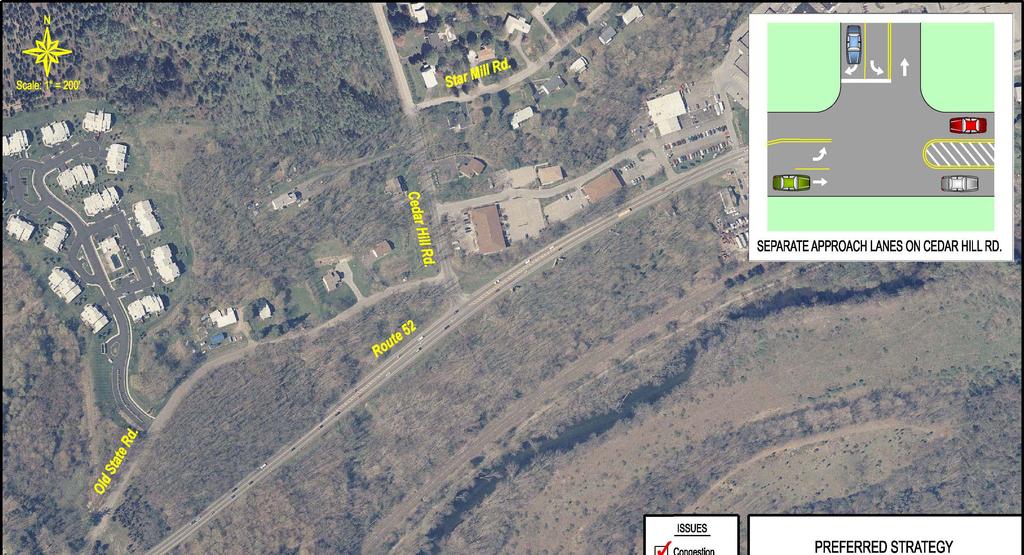
11 CHAPTER 2 LIST OF PREFERRED TRAFFIC IMPROVEMENT STRATEGIES This chapter lists preferred traffic improvement strategies for each of the geographic areas of concentration in the Fishkill Village area. The combination of these preferred traffic improvement strategies will be incorporated into an overall Transportation Improvement Plan. Each geographic area of concentration is described by the following: List of Strategies A list of potential traffic improvement strategies developed to mitigate the identified deficiencies. Preferred Strategy The recommended strategy based on input from the Advisory/Steering Committee and public opinion. Likely Impacts A list of positive and negative impacts associated with the preferred strategy. Public Acceptance An indication whether the preferred strategy was accepted by the public. This also lists any options that were discarded after public meetings. Order of Magnitude Cost IA gross estimate of the construction cost to implement the preferred strategy. The cost does not include drainage, utility, right of way, and maintenance and protection of traffic. 2.1 Route 52/Cedar Hill Road Intersection Potential Strategies 1. Separate turning lanes on Cedar Hill Road 2. Separate turning lanes on Cedar Hill Road and instillation of a traffic signal based on an engineering analysis. Preferred Strategy The preferred strategy is to provide separate turning lanes on Cedar Hill Road. Figure 2.1 shows the preferred traffic improvement strategy for the Route 52/Cedar Hill Road intersection. Likely Impacts + Separate turning lanes will allow the right turn traffic to bypass the left turners and reduce the waiting time for right turn movements. + Minimal property impacts. Page 4
12
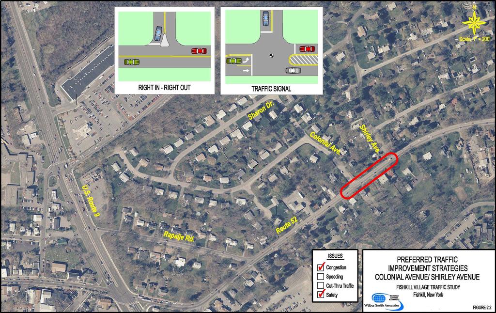
13 Public Acceptance The public accepted the recommendation to provide separate turning lanes on Cedar Hill Road. Order of Magnitude Cost $75,000 includes the cost for separate turning lanes. 2.2 Colonial Avenue-Shirley Avenue Section List of Strategies 1. Do Nothing (Null) 2a. Right-in/Right-out on Colonial Avenue 2b. Right-in/Right-out on Shirley Avenue 3a. Left turn pocket on Route 52 into Colonial Avenue 3b. Left turn pocket on Route 52 into Shirley Avenue 4a. Left turn pocket on Route 52 into Shirley Avenue and Right-in/Right-out on Colonial Avenue 4b. Left turn pocket on Route 52 into Colonial Avenue and Right-in/Right-out on Shirley Avenue 5. Continuous center turn lane on Route 52 between Colonial Avenue and Shirley Avenue 6a. Signal at Route Shirley Avenue intersection with right-in/right-out at Colonial Avenue 6b. Signal at Route Colonial Avenue intersection with Right-in/Right-out at Shirley Avenue Preferred Strategy The preferred strategy by the Steering/Advisory committee was to provide a left turn pocket on Route 52 at either Colonial or Shirley Avenue with a traffic signal and a right-in/right-out at the other location. The public consensus is the Do Nothing strategy. The Village of Fishkill should make a decision on which strategy to implement based on further discussions with the neighborhood and NYSDOT. Figure 2.2 shows the preferred traffic improvement strategies for the Colonial Avenue/Shirley Avenue section. Likely Impacts + The Do Nothing strategy has no property impacts. + A traffic signal will reduce delay on Colonial Avenue or Shirley Avenue. + A left turn pocket on Route 52 would allow through traffic to pass left turning traffic and reduces delay on left turn movements. Page 5
14
15 The Do-Nothing strategy will not improve the delay on Colonial Avenue or Shirley Avenue. Property impacts associated with providing a left turn pocket. Traffic is diverted to Colonial Avenue if Shirley Avenue is right-in/right out and vice versa. Public Acceptance Based on results of survey responses at the Public Meeting for the Colonial Avenue/Shirley Avenue neighborhood, approximately 65 percent of the residents supported a Do- Nothing Alternative, 19 percent favored a traffic signal at Colonial or Shirley, 14 percent favored a center turn lane on Route 52 between Colonial and Shirley Avenue, and the remaining 2 percent favored a left turn pocket on Route 52 at Shirley Avenue. The public opposed the option to provide a paved pedestrian/bicycle path to the Fishkill Plaza. They were content with the existing informal pedestrian/bicycle connection. Order of Magnitude Cost The Do-Nothing strategy does not have any cost associated with it. $350,000 includes cost for a traffic signal, left turn pocket on Route 52, and a right-in/rightout. 2.3 Rapalje Road Section List of Strategies 1. Full cross-sectional enhancement of Rapalje Road with sidewalks, streetscape, a reduced pavement width, a speed table, and Route 52 eastbound left turn restriction. 2. Placement of a speed reduction device such as a speed table, speed hump, or a choker. 3. Placement of a neckdown. 4. Half-closure treatment at the Route 52/Rapalje Road intersection. 5. Right-in/right-out treatment at the Route 52/Rapalje Road intersection. 6. Dead-end Rapalje Road on the Route 9 side. Preferred Strategy The preferred strategy is to provide a full cross-sectional enhancement of Rapalje Road with sidewalks, streetscape, a reduced pavement width, speed table, and left turn restrictions from Route 52 eastbound. Page 6
16 Figure 2.3 compares a rendering of the preferred traffic improvement strategy with the existing Rapalje Road corridor. Likely Impacts + Motorists will slow down while traveling on Rapalje Road. + Motorists may avoid Rapalje Road and go through the Route 9/Route 52 intersection. + Pedestrians are in a safer environment with the addition of sidewalks. Addition of sidewalks and streetscape may impact residential properties. Route 9/Route 52 intersection may experience additional congestion if motorists avoid Rapalje Road. Prohibition of left turns from Route 52 eastbound to Rapalje Road may increase congestion at the Route 9/Elm Street intersection. Public Acceptance The public accepted the recommendation to enhance the cross-section on Rapalje Road with sidewalks, streetscape, speed table, and a narrow pavement width. Based on the public meeting in March, left turn restrictions from Route 52 to Rapalje Road were included in the preferred strategy. The residents along Raplaje Road expressed concern on the cut-through traffic from Main Street using Rapalje Road to bypass the left turn restriction from Main Street to Route 52. Order of Magnitude Cost $625,000 includes cost full cross-sectional enhancement, placement of a speed reduction device and turn restriction from Rote 52 eastbound. Page 7

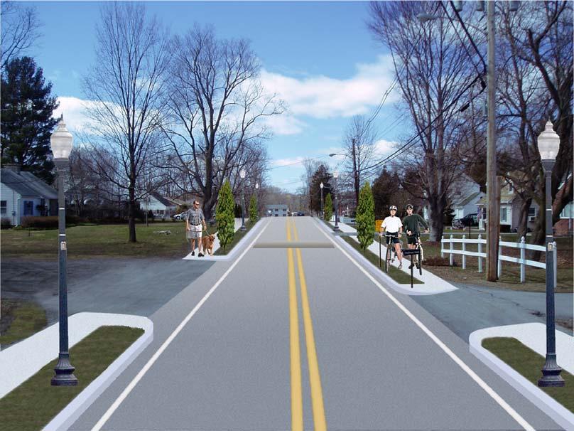
17 Rapalje Road - Before Rapalje Road - After Page 8
18
19 2.4 Broad Street-Smith Street-Elm Street section List of Strategies 1. Full enhancement of the Broad Street-Smith Street-Elm Street section includes improved markings, signage, right-in/right out treatment at the Route 52/Cary Avenue intersection, and a speed table on Broad Street. 2. Placement of neckdowns at mid-block and intersection locations on Broad Street, Smith Street, and Jackson Street. 3. Placement of speed tables, chokers, or speed humps at mid-block locations on Broad Street, Smith Street, and Jackson Street. 4. Raised intersections at the Jackson Street/Broad Street and Smith Street/Broad Street locations. 5. Half closures at the Jackson Street/Broad Street and Smith Street/Broad Street locations. 6. Full closures or dead-ends on Cary Avenue, Smith Street, and Broad Street locations. 7. Placement of a diagonal diverter at the Smith Street/Broad Street intersection. 8. Convert Cary Avenue as a one-way street towards Route 52. Preferred Strategy The preferred strategy is to provide pavement striping and markings on Broad Street, Smith Street, and Elm Street. An all-way STOP sign at the Smith Street/Elm Street and Broad Street/Jackson Street intersections with enhanced geometry is provided. A right-in/right out treatment is provided at the Route 52/Cary Avenue intersection. Placement of a speed table on Broad Street would be included. Figure 2.4 shows the preferred traffic improvement strategy for Broad Street-Smith Street- Elm Street section. Likely Impacts + Motorists are forced to slow down while traveling on Broad Street. + Motorists may avoid Broad Street, Smith Street, and Elm Street and go through the Route 9/Route 52 intersection. + Broad Street, Smith Street, and Elm Street will have increased visibility and more residential character after the cross-sectional enhancements are complete. + Property impacts are minimal. Traffic may divert within the neighborhood to parallel streets. Page 9
20
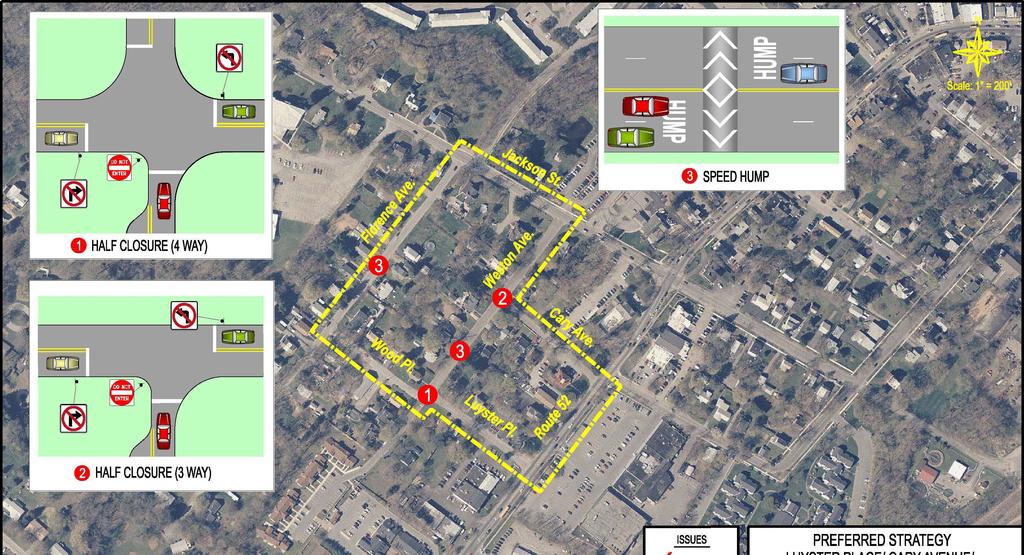
21 Route 9/Route 52 intersection may experience additional congestion if motorists avoid local streets. Public Acceptance In general, public accepted the preferred strategy. The neighborhood suggested additional traffic calming devices to control cut-through traffic at the public meeting. Order of Magnitude Cost $50,000 includes the costs for pavement striping and markings, an all-way STOP sign and right-in/right out treatment, and a speed table. 2.5 Luyster Place-Cary Avenue-Weston Avenue section List of Strategies 1. Install half closures at the Wood Place/Luyster Place and Cary Avenue/Weston Avenue intersections and speed humps along Florence Avenue and Weston Avenue. 2. Placement of neckdowns at mid-block locations along Florence Avenue, Weston Avenue, Cary Avenue, and Luyster Place. Neckdowns are also suggested at the minor street approaches on Jackson Street/Florence Avenue/Rosilia Lane and the Jackson Street/Weston Avenue/Health Center driveway intersections. 3. Placement of speed tables, speed humps, and chokers at mid-block locations along Florence Avenue, Weston Avenue, Wood Place, Cary Avenue, and Luyster Place. 4. Raised intersections at the Florence Avenue/Wood Place, Weston Avenue/Cary Avenue, and Wood Place/Luyster Place intersections. 5. Full closures or dead-ends on Cary Avenue, Luyster Place, and Wood Place (on the Florence Avenue side) locations. 6. Dead end on Cary Avenue and Luyster Place is on the Route 52 side. 7. Conversion of Cary Avenue and Luyster Place as a one-way street away from Route 52. Preferred Strategy The preferred strategy is to provide half closures at the Wood Place/Luyster Place and Cary Avenue/Weston Avenue intersections. Speed humps along Florence Avenue and Weston Avenue are also included in the strategy. Figure 2.5 shows the preferred traffic improvement strategy for the Luyster Place-Cary Avenue-Weston Avenue section. Page 10
22
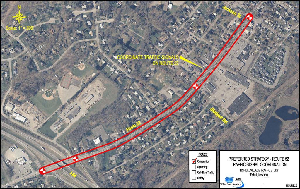
23 Likely Impacts + Motorists will travel on Jackson Street and not divert to local streets. + Motorists are forced to slow down on local streets. Addition of half-closures may have property impacts. Route 52/Jackson Street intersection may experience additional congestion if motorists avoid local streets. Neighborhood travel patterns may be affected due to required diversions. Public Acceptance The public accepted the recommendation to install half-closures at the Wood Place/Luyster Place and Cary Avenue/Weston Avenue intersections. Speed humps along Florence Avenue and Weston Avenue were also supported by the residents. Order of Magnitude Cost $55,000 includes costs for half closures and speed humps. 2.6 Route 52 between Jackson Street and I-84 (Short-Term) List of Strategies 1. Traffic Signal Coordination Coordinate existing traffic signals at Route 52/Jackson Street and Route 52/Blodgett Road with the traffic signals at the I-84 Eastbound and Westbound ramps. Preferred Strategy The preferred strategy is to Coordinate existing traffic signals at Route 52/Jackson Street and Route 52/Blodgett Road with the traffic signals at the I-84 Eastbound and Westbound ramps. Figure 2.6 shows the locations where traffic signal coordination is proposed along Route 52. Likely Impacts + Traffic signal coordination would improve traffic flow on Route Route 52 will experience less congestion. + Signal coordination will reduce the potential of rear-end accidents with fewer stops. + Side streets controlled by STOP signs will get increased gaps in traffic flow. Side streets at traffic signals may experience additional delay. Public Acceptance The public accepted the recommendation to provide traffic signal coordination along Route 52. Page 11
24
25 Order of Magnitude Cost The cost for providing traffic signal coordination is $20,000 (4 intersection locations without an overhead or underground interconnection). 2.7 Sight Distance Improvements (Short Term) List of Strategies 1. Improve intersection distance at a number of locations along Route 52 and Jackson Street. Table 2.1 identifies those locations along with specific issues that would require attention in order to improve sight lines. Table 2.1 Sight Distance Mitigation Sight Distance Restrictions and Strategies Roadway Intersection Looking Left Looking Right Strategies/Considerations Route 52 Jackson Street At Luyster Pl. Large trees Large trees Trees could be removed At Cary Ave. (Southbound) Large trees and bushes None Removal impacts residential property At Broad Street Large tree within the channelization island None Tree could be removed. At Rapalje Road None Small trees Removal impacts residential property Large tree near Removal impacts residential At Colonial Ave. Two large trees and bushes utility boxes property on the east side Removal impacts residential At Weston Ave. None Bushes property Removal impacts residential At Florence Ave. None Tree and fence property Source: Wilbur Smith Associates Preferred Strategy The preferred strategy is to remove trees, brushes, and vegetation wherever appropriate to improve intersection sight lines. Likely Impacts + Sight distance improvements will improve safety specifically angled accidents. Residential properties may be impacted. Page 12
26 Public Acceptance The public accepted the recommendation to improve the intersection sight lines. Order of Magnitude Cost The cost can be part of the Village and Town s maintenance budget. 2.8 Chapter Summary This chapter details for each of the neighborhood areas the list of strategies, recommended strategy by the advisory/steering committee, likely impacts of the strategy on the neighborhood section, public opinion and acceptance, and the order of magnitude cost estimate. A consensus and agreement was reached for all neighborhood sections. The Colonial Avenue/Shirley Avenue neighborhood preferred the Do-Nothing option based on their concern on property impacts and traffic flow in the neighborhood. The Village of Fishkill should make a decision on which strategy to implement based on further discussions with the neighborhood. Page 13
27 CHAPTER 3 OTHER ISSUES/RECOMMENDATIONS AND NEXT STEPS This chapter details other issues/recommendations obtained during the analysis. These issues/recommendations should be further discussed with the Village of Fishkill, Town of Fishkill, Dutchess County Public Works, and the New York State DOT. This chapter also details the next steps in the process relative to implementing the preferred strategies. 3.1 Other Issues/Recommendations During the course of the analysis, several issues/concerns were raised by the residents of the Village and Town of Fishkill which were outside of the scope of this analysis. Below is a list of those issues/concerns and a suggested approach to address these issues/concerns: Traffic Enforcement Residents were concerned about enforcement on local streets such as Rapalje Road, Broad Street, Luyster Place, and others. Implementation of traffic calming devices requires enforcement to a certain degree and the Village and Town of Fishkill should be proactive in increasing the level of enforcement. Speed Reductions along Route 9 and Route 52 There was concern about speeds on Route and Route 52 through the Village area. The response received from the NYSDOT was that the existing regulatory speed limits are appropriate for the current geometry and traffic flow conditions. Pedestrian Crossings at signals Residents expressed concern over pedestrian crossings at traffic signals specifically when a walk signal is shown for the pedestrian, and also why oncoming vehicular left turns are allowed. The response received from the NYSDOT was that There are two methods of accommodating pedestrians at a location that is controlled by a traffic signal: permissive and protected. A permissive pedestrian phase requires pedestrians to cross the road at the same time vehicular traffic is flowing parallel to the crosswalk. This requires turning vehicles to yield to pedestrians that are in the crosswalk, as they would yield to an on-coming through vehicle. A protected pedestrian phase requires all vehicular traffic to stop, allowing pedestrians to cross the intersection without having to worry about turning vehicles. Prohibitions of Right Turns on Red are typically made when a protected pedestrian phase is implemented. No-Right Turn on Red at the Route 52/Jackson Street intersection Residents expressed concern over the No-Right Turn on Red sign at the Route 52/Jackson Street intersection. The NYSDOT response is as follows: The intersection has significant conflicts between turn-on-red vehicles and pedestrians, which warrants the NTOR restrictions. Guiderail on Route 9 Residents expressed concern over the location of the guiderail on Route 9. The issue is that the guiderail is between the sidewalk and the adjacent property not between the roadway and the sidewalk. NYSDOT indicated that the guide-rail in question was installed to prevent vehicles leaving the roadway from going down the existing embankment. Page 14
28 Sidewalks on Route 9 Residents expressed concern over the discontinuity of sidewalks on Route 9. This issue should be further discussed with the Village, Town, and NYSDOT. Striping at Route 52/82 intersection Residents expressed concern over the existing striping at the Route 52/82 intersection. The NYSDOT response is as follows: The double yellow line follows the curvature of Route 52. This is necessary to prevent eastbound vehicles stopped at the stop bar from being in the path of oncoming traffic when westbound Route 52 has a green phase. We believe the existing pavement markings are appropriate. Traffic calming in business district Residents expressed concern over the neckdowns/bulbouts in the center of the Village. The feedback from the Village and NYSDOT was that these devices are appropriate for the business district and will remain in the Village. 3.2 Implementation Plan and Next Steps An implementation plan is needed for the Town and Village of Fishkill to construct the improvements. The Village and Town in cooperation and coordination with the Dutchess County Public Works and the NYSDOT need to develop consensus on actions to be completed, prioritize those actions and work towards implementation. The following are key steps in the implementation plan: Implement the quick fixes or short term improvements such as sight distance, traffic signal coordination, pavement marking striping, signage, etc. Install speed tables and speed humps on a temporary basis and test for a period of days before a physical change is made on the roadway. Work with individual neighborhoods in determining exact locations of traffic calming devices such speed tables and speed humps along the roadway. Develop design plans and documents and detailed engineering study which includes addressing drainage and utilities. The Village and Town and should seek funding through safety and operations improvement programs on a local, state, and federal level. Implement long term improvements (requiring physical changes to the roadway/intersection) such as half-closures based on funding availability. Page 15
CONTENTS EXECUTIVE SUMMARY. 1 SUMMARY OF EXISTING CONDITIONS Issues and Observations Public Meeting (December 2005) 1
 1") CONTENTS CHAPTER PAGE EXECUTIVE SUMMARY ES-1 1 SUMMARY OF EXISTING CONDITIONS 1 1.1 Issues and Observations 1 1.2 Public Meeting (December 2005) 1 2 LIST OF POTENTIAL IMPROVEMENT STRATEGIES 2 2.1 Traffic
CONTENTS CHAPTER PAGE EXECUTIVE SUMMARY ES-1 1 SUMMARY OF EXISTING CONDITIONS 1 1.1 Issues and Observations 1 1.2 Public Meeting (December 2005) 1 2 LIST OF POTENTIAL IMPROVEMENT STRATEGIES 2 2.1 Traffic
Caltrans Sloat Boulevard Pedestrian Safety Project Response to Community Questions, Comments & Concerns
 Caltrans Sloat Boulevard Pedestrian Safety Project Response to Community Questions, Comments & Concerns Revised: May 10, 2016 The California Department of Transportation (Caltrans) is planning various
II. EXISTING NEIGHBORHOODS
 TABLE OF CONTENTS Page I. INTRODUCTION Purpose... 1-1 How To Use This Document... 1-1 Goals and Objectives....... 1-2 History of the Policy.... 1-3 For Further Assistance... 1-6 Policy Revisions......
CITY OF LOS ANGELES INTER-DEPARTMENTAL MEMORANDUM
 CITY OF LOS ANGELES INTER-DEPARTMENTAL MEMORANDUM Date: April 1, 219 To: Honorable City Council c/o City Clerk, Room 395, City Hall Attention: Honorable Mike Bonin, Chair, Transportation Committee From:
122 Avenue: 107 Street to Fort Road
 : 107 Street to Fort Road November 24, 2015 4:30 8:00 p.m. Meeting Purpose Summarize project work completed to date Share results of public input from Phase 1 Share the draft concept plan and proposed
Tonight is for you. Learn everything you can. Share all your ideas.
 Strathcona Neighbourhood Renewal Draft Concept Design Tonight is for you. Learn everything you can. Share all your ideas. What is Neighbourhood Renewal? Creating a design with you for your neighbourhood.
Broad Street Bicycle Boulevard Design Guidelines
 Broad Street Bicycle Boulevard Design Guidelines Building from the strategies introduced in the 2013 Bicycle Transportation Plan and community input received thus far, City Transportation Staff have identified
Water Street Promenade Engineering and Design Services
 Preliminary Design Presentation Parking & Traffic Safety Committee Water Street Promenade Engineering and Design Services July 16,2014 November 3, 2016 Education / Infrastructure / Innovation 1 Project
Town of Mooresville, North Carolina Neighborhood Traffic Calming and Control Device Policy
 Town of Mooresville, North Carolina Neighborhood Traffic Calming and Control Device Policy Adopted January 6, 2014 Town of Mooresville Development Services Department TOWN OF MOORESVILLE NEIGHBORHOOD TRAFFIC
Borough of Danville, PA Traffic Calming Program Guidelines
 Borough of Danville, PA Traffic Calming Program Guidelines Adopted by Borough Council on 1 INTRODUCTION Speeding Traffic is a major concern in the Borough of Danville because of its detrimental impacts
Public Information Centre
 WELCOME Public Information Centre Father Tobin Road Lougheed Middle School - Library Wednesday November 7, 2012 7:00 p.m.to 9:00 p.m. Please sign in Neighbourhood Traffic Calming Guide Background The City
Appendix C. TRAFFIC CALMING PROGRAM TOOLBOX
 Appendix C. TRAFFIC CALMING PROGRAM TOOLBOX PHASE I...2 Do Not Enter Sign...3 One-Way Sign...4 Turn Prohibition...5 Pavement Markings...6 Speed Monitoring Trailer...7 Neighborhood Speed Watch...8 Police
TOWN OF PAYSON TRAFFIC CALMING MANUAL
 TOWN OF PAYSON TRAFFIC CALMING MANUAL APPROVED BY THE PAYSON TOWN COUNCIL SEPTEMBER 6, 2007 TOWN OF PAYSON TRAFFIC CALMING POLICY 1.0 Introduction Traffic Calming involves retrofitting physical devices
Traffic Circulation & Pedestrian Safety Study
 Lyons Township High School North Campus La Grange, Illinois Parking Lot Vaughan Building N Main Building Prepared for: Prepared by: July 23, 2015 Contents List of Figures, iii 1. Introduction...1 2. Existing
County of Spartanburg South Carolina
 County of Spartanburg South Carolina Traffic Calming Program June 2012 (Revised/Program on Hold) PURPOSE The potential negative impacts from vehicular traffic on residential roads have been a longstanding
REGIONAL BICYCLE AND PEDESTRIAN DESIGN GUIDELINES
 REGIONAL BICYCLE AND PEDESTRIAN DESIGN GUIDELINES November 16, 2011 Deb Humphreys North Central Texas Council of Governments Bicycle and Pedestrian Advisory Committee Snapshot of the Guide 1. Introduction
Readington Road (C.R. 637) Construction
 Construction") Public Information Meeting Thursday, August 2, 2012 Readington Road (C.R. 637) Construction from Dreahook Road to Harlan School Road Branchburg Township, Somerset County Readington Township, Hunterdon
Public Information Meeting Thursday, August 2, 2012 Readington Road (C.R. 637) Construction from Dreahook Road to Harlan School Road Branchburg Township, Somerset County Readington Township, Hunterdon
Project Goal and Description. Why Broadway? Broadway SFMTA.COM/BROADWAY. The goal of the Broadway Safety Improvement
 PROJECT OVERVIEW Project Goal and Description The goal of the Broadway Safety Improvement d St Van Ness Ave Project is to improve safety and comfort for all who Franklin St Hyde St Octavia St Gough St
TRANSPORTATION FACILITY PLANNING Waugh Chapel Road Maytime Drive to New Market Lane
 July 24, 2018 TRANSPORTATION FACILITY PLANNING Waugh Chapel Road Maytime Drive to New Market Lane DPWandYOU.com Making a difference, together Meeting Agenda Purpose of the project Overview of work conducted
Corporate. Report COUNCIL DATE: May 25, 1998 NO: R1500 REGULAR COUNCIL. TO: Mayor & Council DATE: April 27, 1998
 R1500 : Traffic Safety at 25 Avenue and 128 Street Intersection Corporate NO: R1500 Report COUNCIL DATE: May 25, 1998 REGULAR COUNCIL TO: Mayor & Council DATE: April 27, 1998 FROM: General Manager, Engineering
TRAFFIC ACTION PLAN. Laurie Meadows Neighborhood CITY OF SAN MATEO
 TRAFFIC ACTION PLAN Laurie Meadows Neighborhood CITY OF SAN MATEO Draft January 2017 Table of Contents Introduction... 2 The Traffic Forum Process... 5 Neighborhood Traffic Issues... 7 Neighborhood Recommendations
WEST AVENUE AND NEW ROAD TRAFFIC STUDY PART III WEST AVENUE CLOSURE ALTERNATIVES ANALYSIS
 WEST AVENUE AND NEW ROAD TRAFFIC STUDY PART III WEST AVENUE CLOSURE ALTERNATIVES ANALYSIS CITY OF LINWOOD ATLANTIC COUNTY, NEW JERSEY March 30, 2006 PREPARED FOR: City of Linwood 400 Poplar Avenue Linwood,
ALLEY 24 TRAFFIC STUDY
 ALLEY 24 TRAFFIC STUDY in City of Frostburg, Maryland January 2013 3566 Teays Valley Road Hurricane, WV Office: (304) 397-5508 www.denniscorporation.com Alley 24 Traffic Study January 2013 Frostburg, Maryland
County of Greenville South Carolina. Traffic Calming Program Neighborhood Traffic Education Program and Speed Hump Program
 County of Greenville South Carolina Traffic Calming Program Neighborhood Traffic Education Program and Speed Hump Program (rev) August 2008 I. PURPOSE The potential negative impacts from vehicular traffic
180 Grand Avenue, Suite x117 Dowling Associates, Inc.
 180 Grand Avenue, Suite 250 510.839.1742 x117 Oakland, CA 94612 510.839.0871 fax www.dowlinginc.com mbowman@dowlinginc.com Dowling Associates, Inc. Date: Memorandum To: CC: From: Ms. Leah Greenblat City
WELCOME Public Information Centre
 WELCOME Public Information Centre Fernforest Drive Brampton Soccer Centre Community Room #2 Tuesday January 19, 2016 6:30 p.m.to 9:00 p.m. Please sign in Neighbourhood Traffic Calming Guide Background
AGENDA REPORT. Issue: Discussion of potential improvements on Barnwell Road at Niblick Drive
 AGENDA REPORT To: From: By: Honorable Mayor and City Council Members Warren Hutmacher, City Manager Tom Black, Public Works Director Date: March 23, 2016 Agenda: March 28, 2016 WORK SESSION AGENDA: Barnwell
Glenn Avenue Corridor Traffic Operational Evaluation
 Glenn Avenue Corridor Traffic Operational Evaluation PREPARED FOR: THE CITY OF AUBURN PREPARED BY: DECEMBER 2007 Glenn Avenue Corridor Study--Auburn, Alabama TABLE OF CONTENTS Introduction... 1 Background
TRAFFIC CALMING GUIDE FOR TORONTO CITY OF TORONTO TRANSPORTATION SERVICES DIVISION
 TRAFFIC CALMING GUIDE FOR TORONTO CITY OF TORONTO TRANSPORTATION SERVICES DIVISION CITY OF TORONTO TRANSPORTATION SERVICES DIVISION 2016 TRAFFIC CALMING GUIDE FOR TORONTO TABLE OF CONTENTS Introduction
Military Road Safety Improvements
 Military Road Safety Improvements 26 th Road North to 31 st Street North SUMMARY OF DATA REVIEW AND PRELIMINARY RECOMMENDATIONS Prepared for: Department of Environmental Services Traffic Engineering and
CITY OF SAINT JOHN TRAFFIC CALMING POLICY
 CITY OF SAINT JOHN TRAFFIC CALMING POLICY VERSION: 1.0 April 10, 2012 Pedestrians, Cyclists and Motorists Sharing Street Spaces CONTENTS INTRODUCTION... 3 POLICY GOAL... 3 POLICY OBJECTIVES... 3 GUIDING
TOWN OF HALTON HILLS TRAFFIC CALMING PROTOCOL. Page 1 of 25
 TOWN OF HALTON HILLS TRAFFIC CALMING PROTOCOL Page 1 of 25 PROCESS FOR INSTALLATION OF TRAFFIC CALMING DEVICES The Process for Installation of Traffic Calming Devices has been prepared to provide an objective
TRAFFIC CALMING POLICY NEWTOWN TOWNSHIP DELAWARE COUNTY, PA
 TRAFFIC CALMING POLICY NEWTOWN TOWNSHIP DELAWARE COUNTY, PA September 2014 1 TABLE OF CONTENTS INTRODUCTION... 3 PURPOSE AND GOALS... 3 DEFINITIONS... 4 APPLICABILITY... 5 ELIGIBLE STREETS... 5 LOCATION
Evaluation of M-99 (Broad Street) Road Diet and Intersection Operational Investigation
 Road Diet and Intersection Operational Investigation") Evaluation of M-99 (Broad Street) Road Diet and Intersection Operational Investigation City of Hillsdale, Hillsdale County, Michigan June 16, 2016 Final Report Prepared for City of Hillsdale 97 North Broad
Evaluation of M-99 (Broad Street) Road Diet and Intersection Operational Investigation City of Hillsdale, Hillsdale County, Michigan June 16, 2016 Final Report Prepared for City of Hillsdale 97 North Broad
Chapter 3: Multi-Modal Circulation and Streetscapes
 CHAPTER 3: MULTI-MODAL CIRCULATION AND STREETSCAPES Chapter 3: Multi-Modal Circulation and Streetscapes Overview Streetscape improvements have already been completed for Depot Street between Main Avenue
Corpus Christi Metropolitan Transportation Plan Fiscal Year Introduction:
 Introduction: The Safe, Accountable, Flexible, Efficient Transportation Equity Act: A Legacy for Users (SAFETEA-LU) has continued the efforts started through the Intermodal Surface Transportation Efficiency
EXHIBIT R1. Neighborhood Cul-de-Sac Implementation
 Neighborhood Cul-de-Sac Implementation The traffic study conducted for the Talaria project analyzed the amount of project traffic expected to use local, residential streets immediately north of the project
Improving Cyclist Safety at the Dundas Street West and Sterling Road Intersection
 STAFF REPORT ACTION REQUIRED Improving Cyclist Safety at the Dundas Street West and Sterling Road Intersection Date: August 17, 2012 To: From: Wards: Reference Number: Public Works and Infrastructure Committee
Community Transportation Plan
 Community Transportation Plan Appendix A: Traffic Calming CITY OF DECATUR COMMUNITY TRANSPORTATION PLAN Appendix A: City of Decatur City-wide Residential Traffic Calming Program Process & Procedures The
Intersection Traffic Control Feasibility Study
 Intersection Traffic Control Feasibility Study CSAH 9 at CSAH 60 (185th Avenue) Prepared For: Dakota County Transportation Department Western Service Center 14955 Galaxie Avenue, 3rd Floor Apple Valley,
Shockoe Bottom Preliminary Traffic and Parking Analysis
 Shockoe Bottom Preliminary Traffic and Parking Analysis Richmond, Virginia August 14, 2013 Prepared For City of Richmond Department of Public Works Prepared By 1001 Boulders Pkwy Suite 300, Richmond, VA
Community Meeting February 27, 2007 Dorchester Avenue Transportation & Streetscape Improvements Action Plan February 27, 2007
 Community Meeting Tonight s Agenda 6:00 Introductions South Boston/Dot Ave Improvement Study Background 6:15 Consultant Introductions Review of Scope and Schedule Review of Proposed Corridor Wide Guidelines
CITY OF VISTA TRAFFIC CALMING PROGRAM
 CITY OF VISTA TRAFFIC CALMING PROGRAM The purpose of the Vista Traffic Calming Program is to reduce speeds of motorists driving through residential neighborhoods. The program does not apply to nonresidential
Neighborhood Traffic Calming Guidelines
 Neighborhood Traffic Calming Guidelines ADOPTED BY THE CITY COUNCIL OF ARROYO GRANDE BY RESOLUTION NO. 2016-4718 ON APRIL 12, 2016 COMMUNITY DEVELOPMENT DEPARTMENT ENGINEERING DIVISION 300 East Branch
Traffic Calming Policy
 City of Friendswood Traffic Calming Policy May 2012 Community Development Department Table of Contents Title Page Table of contents... 1 Background and History... 2 Purpose and Goals... 2 City Procedure
J Street and Folsom Boulevard Lane Conversion Project (T ) Before and After Traffic Evaluation
 Before and After Traffic Evaluation") J Street and Folsom Boulevard Lane Conversion Project (T15125400) Before and After Traffic Evaluation Prepared by Transportation Division June 2014 Executive Summary On February 12, 2013, the City of Sacramento
J Street and Folsom Boulevard Lane Conversion Project (T15125400) Before and After Traffic Evaluation Prepared by Transportation Division June 2014 Executive Summary On February 12, 2013, the City of Sacramento
CITY OF SLO SEEKS INPUT ON PREFERRED ALTERNATIVE FOR BROAD STREET BICYCLE BOULEVARD PROJECT
 City of San Luis Obispo, News Release DATE: August 1, 2017 RELEASE: Immediate CONTACT: Luke Schwartz (805) 781-7190 Transportation Planner-Engineer, Public Works CITY OF SLO SEEKS INPUT ON PREFERRED ALTERNATIVE
Seattle Department of Transportation (SDOT) Preliminary Responses to Madison-Miller Community List of Site-Specific Concerns
 Preliminary Responses to Madison-Miller Community List of Site-Specific Concerns") Seattle Department of Transportation (SDOT) Preliminary Responses to Madison-Miller Community List of Site-Specific Concerns Background In July 2002 SDOT staff met with a small group of community residents
Seattle Department of Transportation (SDOT) Preliminary Responses to Madison-Miller Community List of Site-Specific Concerns Background In July 2002 SDOT staff met with a small group of community residents
DEPARTMENT OF ENVIRONMENTAL SERVICES. North Harrison Street (Lee Highway to Little Falls Road) Comparative Analysis. Prepared for:
 Comparative Analysis. Prepared for:") DEPARTMENT OF ENVIRONMENTAL SERVICES North Harrison Street (Lee Highway to Little Falls Road) Comparative Analysis Prepared for: Arlington County Department of Environmental Services 2100 Clarendon Boulevard,
DEPARTMENT OF ENVIRONMENTAL SERVICES North Harrison Street (Lee Highway to Little Falls Road) Comparative Analysis Prepared for: Arlington County Department of Environmental Services 2100 Clarendon Boulevard,
Complete Street Analysis of a Road Diet: Orange Grove Boulevard, Pasadena, CA
 Complete Street Analysis of a Road Diet: Orange Grove Boulevard, Pasadena, CA Aaron Elias, Bill Cisco Abstract As part of evaluating the feasibility of a road diet on Orange Grove Boulevard in Pasadena,
Interstate Route 77 / US Route 62 / State Route 687 (Fulton Road) Transportation Improvement Project. Prepared September 6, 2017
 Transportation Improvement Project. Prepared September 6, 2017") EODOT Project: ODOT Project: STA-IR 77-.50; PID 00290 Interstate Route 77 / US Route 62 / State Route 687 (Fulton Road) Transportation Improvement Project Summary of Public Comments Received and Responses
EODOT Project: ODOT Project: STA-IR 77-.50; PID 00290 Interstate Route 77 / US Route 62 / State Route 687 (Fulton Road) Transportation Improvement Project Summary of Public Comments Received and Responses
CITY OF OTTAWA ROADWAY MODIFICATION APPROVAL UNDER DELEGATED AUTHORITY
 RMA-2015-ATM-038 CITY OF OTTAWA ROADWAY MODIFICATION APPROVAL UNDER DELEGATED AUTHORITY DATE: April 22, 2015 SUBJECT Approval of Roadway Modifications Recommended through an Area Traffic Management Study
NEIGHBORHOOD TRAFFIC CALMING POLICY
 NEIGHBORHOOD TRAFFIC CALMING POLICY I. PURPOSE The City of Kent continually strives to strengthen and protect its neighborhoods by improving the quality of life in residential areas. Traffic conditions
City of Wayzata Comprehensive Plan 2030 Transportation Chapter: Appendix A
 A1. Functional Classification Table A-1 illustrates the Metropolitan Council s detailed criteria established for the functional classification of roadways within the Twin Cities Metropolitan Area. Table
City of Elizabeth City Neighborhood Traffic Calming Policy and Guidelines
 City of Elizabeth City Neighborhood Traffic Calming Policy and Guidelines I. Purpose: The City of Elizabeth City is committed to ensure the overall safety and livability of residential neighborhoods. One
VILLAGE OF NILES TRAFFIC CALMING POLICY
 INTRODUCTION There is increasing interest across the country in developing new strategies to reduce the speed and amount of traffic in residential neighborhoods. Measurement of speeds, traffic volumes,
4. ENVIRONMENTAL IMPACT ANALYSIS 9. TRANSPORTATION AND TRAFFIC
 4. ENVIRONMENTAL IMPACT ANALYSIS 9. TRANSPORTATION AND TRAFFIC 4.9.1 INTRODUCTION The following section addresses the Proposed Project s impact on transportation and traffic based on the Traffic Study
CITY OF COCONUT CREEK IMPLEMENTATION GUIDELINES FOR TRAFFIC CALMING
 CITY OF COCONUT CREEK IMPLEMENTATION GUIDELINES FOR TRAFFIC CALMING I. Introduction: The City of Coconut Creek recognizes that the conditions of residential streets can greatly affect neighborhood livability;
CITY OF ROCK HILL, SOUTH CAROLINA. Neighborhood Traffic Calming Program A Policy for Use of Traffic Calming on Local (Residential) Streets
 Streets") CITY OF ROCK HILL, SOUTH CAROLINA Neighborhood Traffic Calming Program A Policy for Use of Traffic Calming on Local (Residential) Streets I. Statement of Purpose: This program provides a process and a
CITY OF ROCK HILL, SOUTH CAROLINA Neighborhood Traffic Calming Program A Policy for Use of Traffic Calming on Local (Residential) Streets I. Statement of Purpose: This program provides a process and a
Blair Park Traffic Calming Study
 Blair Park Traffic Calming Study Williston, Vermont Prepared for: Chittenden County Regional Planning Commission Town of Williston, Vermont Prepared by: Stantec Consulting Services Inc. 55 Green Mountain
MINERAL AVENUE CORRIDOR ASSESSMENT STUDY IMPLEMENTATION STRATEGY
 MINERAL AVENUE CORRIDOR ASSESSMENT STUDY IMPLEMENTATION STRATEGY INTRODUCTION City Personnel Sign-in Sheet Comment Forms Please Write Down Any Feedback INTRODUCTION List of Topics for Presentation Study
TRAFFIC IMPACT ANALYSIS
 TRAFFIC IMPACT ANALYSIS FOR THE CHAMPAIGN UNIT#4 SCHOOL DISTRICT PROPOSED HIGH SCHOOL (SPALDING PARK SITE) IN THE CITY OF CHAMPAIGN Final Report Champaign Urbana Urbanized Area Transportation Study 6/24/2014
Table of Contents Introduction...1. A. Background B. Introduction to Traffic Calming Devices Purpose Statement...
 Borough of Brentwood February 23, 2010 Neighborhood Traffic Calming FINAL Program Table of Contents Neighborhood Traffic Calming Program 192-01 Introduction...1 A. Background... 1 B. Introduction to Traffic
AGENDA ITEM SUMMARY SPECIAL AGENDA ITEM NO. _1A_
 AGENDA ITEM SUMMARY AGENCY: City Council MEETING DATE: June 25, 2012 DEPARTMENT: Community Dev PREPARED BY: T Spade DEPT. DIR. APPROVAL: MJ CITY MGR. APPROVAL: LR PRESENTED BY: T Spade TITLE: RECEIVE REPORT
City of Prince Albert Statement of POLICY and PROCEDURE. Department: Public Works Policy No. 66. Section: Transportation Issued: July 14, 2014
 Page: 1 of 8 1 POLICY 1.01 The City shall follow all of the specifications in the Manual of Uniform Traffic Control Devices for Canada, prepared by the National Committee of Uniform Traffic Control, and
Agenda. Overview PRINCE GEORGE S PLAZA METRO AREA PEDESTRIAN PLAN
 PRINCE GEORGE S PLAZA METRO AREA PEDESTRIAN PLAN May 28, 2008 Agenda Welcome and introductions Project overview and issue identification Planning context and strengths Design challenges and initial recommendations
Reference number /VP. Lafayette Downtown Congestion Study - Additional Traffic Analysis
 To James Hinkamp and Tony Coe, City of Lafayette Date January 19, 2017 Copies Reference number 243381/VP From Michael Iswalt and Vanessa Peers File reference 4-05 Subject Lafayette Downtown Congestion
Mineral Avenue Corridor Assessment. ITE 2017 Western District Annual Meeting San Diego, CA June 21 st
 Mineral Avenue Corridor Assessment ITE 2017 Western District Annual Meeting San Diego, CA June 21 st Biography - Aaron Heumann, PE, PTOE Currently City of Littleton Transportation Engineering Manager 24
TOWN OF CHAPEL HILL POLICY AND PROCEDURES FOR TRAFFIC CALMING MEASURES
 TOWN OF CHAPEL HILL POLICY AND PROCEDURES FOR TRAFFIC CALMING MEASURES (Adopted by the Town Council on June 30, 2004) (Revised December 6, 2010) (Revised February 8, 2016) POLICY AND PROCEDURES FOR TRAFFIC
Byron Avenue. Public Meeting. Thursday June 16, Traffic Calming Design Sherbourne Road to Island Park Drive
 Byron Avenue Traffic Calming Design Sherbourne Road to Island Park Drive Public Meeting Thursday June 16, 2016 Our Lady of Fatima Parish 153 Woodroffe Avenue 6 9pm 1 Project Summary Area Projects Background
WISCONSIN AVENUE EXTENSION SECOND PUBLIC INFORMATION MEETING. March 28, 2017
 WISCONSIN AVENUE EXTENSION SECOND PUBLIC INFORMATION MEETING March 28, 2017 STUDY AREA N MEETING AGENDA Introductions Study Background Alternatives Studied Recommended Alternative Discussion STUDY BACKGROUND
ROUTE 22 CORRIDOR STUDY: CORRIDOR MANAGEMENT PLAN APPENDIX A A-12
 ROUTE 22 CORRIDOR STUDY: CORRIDOR MANAGEMENT PLAN APPENDIX A A-12 3.0 HARLEM VALLEY TRANSPORTATION PLAN Incorporates transportation systems management and safety improvements. Location: Route 22 corridor
Memorandum. Sunday, July 13, Saturday, July 19, 2014
 Memorandum To: David Lowin, Brooklyn Bridge Park Corporation From: Daniel Schack, AICP, PTP Date: Re: Brooklyn Bridge Park Pier 5/6 Loop Road Traffic Study Project No: 14-01-2407 At the request of Brooklyn
MEMORANDUM TERESA MCCLISH, COMMUNITY DEVELOPMENT DIRECTOR SUBJECT: CONSIDERATION OF DRAFT NEIGHBORHOOD TRAFFIC CALMING GUIDELINES
 MEMORANDUM TO: FROM: BY: TRAFFIC COMMISSION TERESA MCCLISH, COMMUNITY DEVELOPMENT DIRECTOR MATT HORN, CITY ENGINEER SUBJECT: CONSIDERATION OF DRAFT NEIGHBORHOOD TRAFFIC CALMING GUIDELINES DATE: MARCH 28,
THE ALAMEDA CONCEPT DESIGN COMMUNITY MEETING 3. A Plan for The Beautiful Way JANUARY 28, 2010
 CONCEPT DESIGN COMMUNITY MEETING 3 JANUARY 28, 2010 AGENDA INTRODUCTION COMMUNITY INPUT ROADWAY STUDIES STREETSCAPE DESIGN STATIONS DISCUSSION SUMMARY AND DISCUSSION NEXT STEPS CLOSE INTRODUCTION SCHEDULE
Town of Southwest Ranches Neighborhood Traffic Calming Program
 Town of Southwest Ranches The provides residents an opportunity to present a concern for traffic safety with respect to observed volume and speeds on neighborhood streets and a formal method to study and
Prepared By: Town of Waxhaw Traffic Calming Policy
 Policy For Resolutions for Town Meetings Prepared By: Town Manager Michael McLaurin Director Greg Mahar CPD Waxhaw N.C. Community Planning &Development Administrative Department Department: Date Approved
HARRISON STREET/OAKLAND AVENUE COMMUNITY TRANSPORTATION PLAN
 HARRISON STREET/OAKLAND AVENUE Community Workshop #4: Draft Plan Review December 3, 2009 D E S I G N, C O M M U N I T Y & E N V I R O N M E N T INTRODUCTIONS Key Project Staff: Alisa Shen, Project Manager,
Draft Traffic Calming Policy Paper
 Draft Traffic Calming Policy Paper What is Traffic Calming The term traffic calming is defined differently throughout the United States. The Institute of Transportation Engineers, an international educational
A plan for improved motor vehicle access on Railroad Avenue in Provincetown
 A plan for improved motor vehicle access on Railroad Avenue in Provincetown February 2011 A plan for improved motor vehicle access on Railroad Avenue in Provincetown INTRODUCTION AND PROBLEM IDENTIFICATION
MEMORANDUM. Date: 9/13/2016. Citywide Crosswalk Policy
 MEMORANDUM Date: 9/13/2016 Re: Citywide Crosswalk Policy Foreword Through the s Circulation Element and Complete Streets Policy, it is the City s goal to promote walking trips and provide safe facilities
SAN FRANCISCO MUNICIPAL TRANSPORTATION AGENCY
 THIS PRINT COVERS CALENDAR ITEM NO. : 10.2 DIVISION: Sustainable Streets BRIEF DESCRIPTION: SAN FRANCISCO MUNICIPAL TRANSPORTATION AGENCY Adopting Conceptual Proposal for Streetscape Improvements to Broadway,
POLICY: TRAFFIC CALMING
 2006 MAY REFERENCE: COUNCIL APPROVED BY COUNCIL MAY 23, 2006 CITY OPERATIONS - NO. 608 POLICY: TRAFFIC CALMING A. All requests for traffic calming within the City shall be considered in accordance with
Town of Bethlehem. Planning Assessment. Bethlehem Town Board
 Town of Bethlehem US 9W Corridor Transportation Planning Assessment Presented e to: Bethlehem Town Board June 2009 Overview Study Background Route 9W Corridor Conditions and Improvements Selkirk Bypass
HIGHBURY AVENUE/HAMILTON ROAD INTERSECTION IMPROVEMENTS PUBLIC INFORMATION CENTRE 1 MAY 14, 2015
 HIGHBURY AVENUE/HAMILTON ROAD INTERSECTION IMPROVEMENTS Municipal Class Environmental Assessment PUBLIC INFORMATION CENTRE 1 MAY 14, 2015 ACCESSIBILITY Under the Accessibility Standards 2015 for Customer
Traffic Improvements for the Transit Oriented Development District (TODD) Meriden Public Library March 11, 2014
 Meriden Public Library March 11, 2014") Traffic Improvements for the Transit Oriented Development District (TODD) Meriden Public Library March 11, 2014 Project Overview Coordinate roadway improvements with other major projects HUB Flood Control
Traffic Improvements for the Transit Oriented Development District (TODD) Meriden Public Library March 11, 2014 Project Overview Coordinate roadway improvements with other major projects HUB Flood Control
City of Tamarac, Florida Traffic Calming Policy
 City of Tamarac, Florida Traffic Calming Policy Temp. Reso. 12614 Exhibit 1 I. Introduction: The City of Tamarac recognizes that the conditions of residential streets can greatly affect neighborhood livability
West Broad Street Traffic Study
 West Broad Street Traffic Study Prepared for the Town of Plainville by Central Connecticut Regional Planning Agency (CCRPA) October 2011 Central Connecticut Regional Planning Agency 225 N. Main St. Suite
City of Albert Lea Policy and Procedure Manual 4.10 ALBERT LEA CROSSWALK POLICY
 4.10 ALBERT LEA CROSSWALK POLICY PURPOSE: Pedestrian crosswalks are an integral part of our transportation infrastructure. To be effective and promote safety, marked crosswalks must be installed after
Memo. Ocean Avenue Corridor Design Project Public Workshop #2 Summary
 Ocean Avenue Corridor Design Project Public Workshop #2 Summary The second public workshop for the Ocean Avenue Corridor Design Project was held on Wednesday, May 14, 2014 from, 6 to 8 pm at Lick Wilmerding
Brian McHugh, Buckhead Community Improvement District. SUBJECT: Wieuca Road at Phipps Boulevard Intersection Improvements Project
 MEMO TO: FROM: Brian McHugh, Buckhead Community Improvement District Jagan Kaja, AICP, WSP Parsons Brinckerhoff SUBJECT: Wieuca Road at Phipps Boulevard Intersection Improvements Project DATE: October
Citizens Handbook for Requesting Traffic Calming Devices
 Citizens Handbook for Requesting Traffic Calming Devices January 19, 2015 Table of Contents 1. PURPOSE... - 1-2. DEFINITIONS... - 2-3. GENERAL INFORMATION... - 3-3.1. ELIGIBILITY REQUIREMENTS... - 3-3.2.
Albany Shaker Road Corridor Study Public Meeting # 2
 Albany Shaker Road Corridor Study Public Meeting # 2 Scope / Meeting Purpose This project is a CDTC Linkage Study. The Linkage Program is designed to implement the adopted planning and investment principles
NORTH TURNAROUND. Recommended Design: Expand the existing transit terminal
 NORTH TURNAROUND Recommended Design: Expand the existing transit terminal Feedback from stakeholders and the public: Make it easy to transfer between local and Rapid Transit service Why is this design
5 Circulation & Parking
 5 Circulation & Parking Downtown Parking & Circulation Strategy. Downtown Wayne has a somewhat disconnected system of local public streets to connect downtown with the residential neighborhoods, and primary
Executive Summary Route 30 Corridor Master Plan
 Route Corridor Master Plan Project Overview The Route Corridor Master Plan is a coordinated multimodal transportation and land use plan for the entire stretch of Route through East Whiteland Township,
Appendix A: Crosswalk Policy
 Appendix A: Crosswalk Policy Appendix A: Crosswalk Policy Introduction This citywide Crosswalk Policy is aimed at improving pedestrian safety and enhancing pedestrian mobility by providing a framework
Residential Traffic Calming Program Guide. Town of Ashland, Virginia
 Residential Traffic Calming Program Guide Town of Ashland, Virginia August 1, 2006 TABLE OF CONTENTS A. INTRODUCTION... 1 B. GOALS... 1 C. CRITERIA... 1 D. IDENTIFYING NEIGHBORHOOD TRAFFIC CONCERNS...
Southside Road. Prepared for: City of St. John s Police & Traffic Committee. Prepared by: City of St. John s Traffic Division
 Southside Road Prepared for: City of St. John s Police & Traffic Committee Prepared by: City of St. John s Traffic Division January 2007 Southside Road - Traffic Report Page 1 of 9 BACKGROUND: th At the
City of Vallejo Traffic Calming Toolbox
 City of Vallejo Traffic Calming Toolbox June 1, 2013 Final Table of Contents Introduction... 1 Non-Physical Devices... 3 High-Visibility Crosswalk... 3 In Pavement Lighted Crosswalk... 4 Rapid Flashing