Gosford to Lisarow. 202m
|
|
|
- Rudolf Byrd
- 5 years ago
- Views:
Transcription


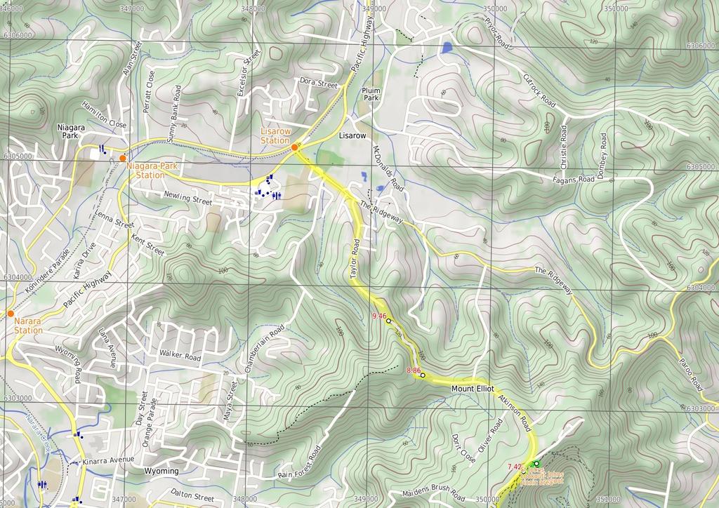
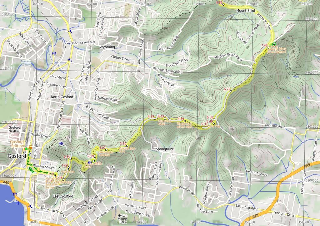
1 Gosford to Lisarow 4 hrs 3 mins Hard track 11.3 km One way 4 479m This walk is a great way to explore the ridge-top bushland between Gosford and Lisarow. Passing through Rumbalara and Katandra Reserves, there are several picnic area, lookouts and other facilities scattered along the way. At times you will forget you are anywhere near houses, and at other points you will be enjoying vistas of the Central Coast. Much of the road walk toward the end is through a rural setting, making an enjoyable walk. 22m 4m Katandra Reserve Maps, text & images are copyright wildwalks.com Thanks to OSM, NASA and others for data used to generate some map layers.

2 Rumbalara Environmental Education Centre Before You walk This centre is 'a New South Wales Department of Education and Training facility that provides environmental education and field work opportunities to students, teachers and the community of the Central Coast'. The centre is at the end of Donnison St, Gosford and is a good access point to some of the walking tracks in the adjoining Rumbalara Reserve. More info. Bushwalking is fun and a wonderful way to enjoy our natural places. Sometimes things go bad, with a bit of planning you can increase your chance of having an ejoyable and safer walk. Before setting off on your walk check Ouraka Point This picturesque spot with fantastic views over Gosford and the surrounding areas, including Brisbane Waters, is located within the Rumbalara Reserve, along the Casuarina Walk. It is a beautiful spot to sit and enjoy the views for a while during a walk in the reserve. Casuarina Commonly known as the she-oak, sheoak, ironwood, or beefwood, casuarinas have 'delicate, slender ultimate branches and leaves that are no more than scales, making the tree look more like a wispy conifer'. There are 17 species of Casuarina 'native to Australasia, southeastern Asia, and islands of the western Pacific Ocean'. More info. Yaruga Picnic Area This picnic area is right beside Dolly Ave, within the Rumbalara Reserve, Gosford. The facilities include free electric BBQs, picnic tables, toilets and garbage bins. There are information boards with details of the walking tracks and other features of the reserve. There are a couple of lookout points at the edge of the picnic area with great views out across Gosford and the surrounding areas. Wannagan Lookout The fenced Wannagan Lookout, on the Red Gum Walk, has great views over North Gosford. The fenced lookout sits at the top of a small cliff. Out of sight, beneath the lookout, is some great cliff and overhang scenery. 1) Weather Forecast (BOM Hunter District) 2) Fire Dangers (Greater Sydney Region) 3) Park Alerts () 4) Research the walk to check your party has the skills, fitness and equipment required 5) Agree to stay as a group and not leave anyone to walk solo Think before you TREK The 'Think before you TREK' program developed by NSW Police & NPWS promotes the benefits of planning ahead for your bushwalking trip by using an easy to remember acronym: adequate supplies of food, water, navigation and first T Take aid equipment. your planned route and tell friends and family when R Register you expect to return. beacon (PLB's) should be carried on walks with E Emergency significant gaps in mobile coverage (check terrain profile). to your planned route and follow the map and walking K Keep trails. Topo Maps The maps provided on wildwalks are helpful, but there are times where you may need maps covering a broader area. Maps that cover this walk include; 1:25 Map Series:91312S GOSFORD 1:1 Map Series:9131 GOSFORD Grade This walk has been graded using the AS The overall grade of the walk is dertermined by the highest classification along the whole track. 4 Grade 4/6 Hard track Length 11.3 km One way Time 4 hrs 3 mins Quality of track Formed track, with some branches and other obstacles (3/6) Signs Minimal directional signs (4/6) Experience Required Some bushwalking experience recommended (3/6) Weather Weather generally has little impact on safety (1/6) Infrastructure Limited facilities, not all cliffs are fenced (3/6)
3 Are you ready to have fun? Please ensure you and your group are well prepared and equipped for all possible hazards and delays. Check park closures, weather information and Fire Danger Rating before setting out. Optional side trips and alternate routes noted are not included in this walks overall grade, length or time estimate. Please allow extra time for resting and exploring areas of interest. The authors, staff and owners of wildwalks take care in preparing this information but will not accept responsibility for any inconvenience, loss or injury you may experience. Please take care, have fun - Happy Walking. Getting there You can get to Gosford Station (gps: , ) by car, train or bus. Car: There is free parking available. You can get back from Lisarow Station (gps: , ) by car or bus. Car: There is free parking available. Find up to date and more information inlcuding; travel directions, weather, park closures and walker feedback at Gosford Station (1 km 19 mins) From the train station, this walk heads out the main eastern exit and crosses the Pacific Hwy using the glass-covered footbridge. On the other side of the bridge, the walk heads down the stairs and turns left to walk along the footpath (next to the Highway, with the train station now on the right). The walk then crosses Erina St and, soon after, turns left into William St Mall. At the other end of the mall, the walk heads diagonally through Kibble Park and crosses Henry Parry Dr at the lights. Here, the walk heads uphill along Donnison St, passing Albany St. When Donnison St bends right, this walk continues straight up the hill a short distance into to Rumbalara Environmental Education Centre car park. Turn right: From the car park, this walk follows the 'Rumbalara Environmental Education Centre' arrow along the paved foopath to the trackhead at the back of the buildings, signposted 'Walking Trail'. 1.1 Rumbalara Environmental Education Centre This centre is 'a New South Wales Department of Education and Training facility that provides environmental education and field work opportunities to students, teachers and the community of the Central Coast'. The centre is at the end of Donnison St, Gosford and is a good access point to some of the walking tracks in the adjoining Rumbalara Reserve. More info. 1.1 Rumbalara Environmental Education Centre trackhead (14 m 4 mins) Turn left: From the trackhead at the back of the Rumbalara EEC, this walk follows the 'Walking Trail' arrow up the steps and along the track. The track crosses a small wooden bridge and bends to the right, then climbs a little to an intersection with a management trail. Turn right: From the intersection, this walk follows the management trail gently up the hill, leaving the bush track steps behind to the right. The trail goes gently up the hill for a short distance to an intersection at the bottom of a metal staircase, signposted 'Casuarina Track' Int of Casuarina track and JWD link trail (25 m 7 mins) Turn left: From the intersection, this walk follows the 'Picnic Areas' arrow up the staircase. The walk then continues a short distance up the sandstone path and steps to an intersection with a management trail, marked by a track information board and a 'Casuarina Track' signpost pointing back to the 'Field Studies Centre'. Turn left: From the intersection, this walk follows the 'Picnic Areas' arrow along the management trail, going gently up the hill. After a short distance, the walk arrives at an intersection with steps and a metal staircase to the left. Continue straight: From the intersection, this walk goes up the sandstone steps, then the metal staircase. The walk then crosses the end of the management trail and continues up the long flight of sandstone steps. After a short distance, the walk passes some large boulders (to the left) and soon arrives at the signposted 'Ouraka Point', with beautiful views over Gosford and the surrounding areas and waterways Ouraka Point This picturesque spot with fantastic views over Gosford and the surrounding areas, including Brisbane Waters, is located within the Rumbalara Reserve, along the Casuarina Walk. It is a beautiful spot to sit and enjoy the views for a while during a walk in the reserve Ouraka Point (25 m 5 mins) Continue straight: From Ouraka Point, this walk follows the management trail going gently up the hill, leaving the seats and Ouraka Point behind to the left. After a while, the walk passes an informal, unfenced lookout area with obscured but nice views over Gosford, to the left. The walk continues a little further to an intersection, with a 'Casuarina Track' signpost pointing back to 'Ouraka Point'. Continue straight: From the intersection, this walk follows the 'Picnic Areas' arrow along the management trail, keeping the views of Gosford to the left. After a short distance, the walk arrives at a sculpture of Charles Sturt, to the right Casuarina Commonly known as the she-oak, sheoak, ironwood, or beefwood, casuarinas have 'delicate, slender ultimate branches and leaves that are no more than scales, making the tree look more like a wispy conifer'. There are 17 species of Casuarina 'native to Australasia, southeastern Asia, and islands of the western Pacific Ocean'. More info Sculpture of Charles Sturt (17 m 3 mins) Continue straight: From the sculpture, this walk follows the management trail, keeping the views of Gosford to the left, and leaving Charles Sturt behind on the right. The walk continues along the trail to an intersection with a paved track, signposted 'Casuarina Track'. Veer right: From the intersection, this walk follows the management trail up the hill leaving the paved 'Casuarina Track' behind on the left. After a very short distance, the walk arrives at an intersection with a bush track, signposted 'Flannel Flower Track' Flannel Flower walk signpost (72 m 17 mins) Veer right: From the intersection, this walk follows the 'Yaruga Picnic Area' arrow along the bush track, going gently down the hill. The walk meanders along the side of the hill for some time, passing occasional sandstone steps before continuing past an intersection with a bush track (on the left, uphill), and another soon after (on the right, downhill). The walk continues for some distance, climbing gently with numerous steps, before arriving beside the toilet block at Yaruga Picnic Area. The walk turns right and follows the paved path past the information board, then goes across the picnic area, following the 'Lookout' arrow to the electric BBQs Yaruga Picnic Area This picnic area is right beside Dolly Ave, within the Rumbalara Reserve, Gosford. The facilities include free electric BBQs, picnic tables, toilets and garbage bins. There are information boards with details of the walking tracks and other features of the reserve. There are a couple of lookout points at the edge of the picnic area with great views out across Gosford and the surrounding areas Optional sidetrip to Yaruga Lookout (2 m 1 mins) Turn right: From the BBQs, this walk goes a very short distance across the picnic area, away from the road, passing the 'Yaruga Lookout' sign, to the left, and the 'Orchid Track' and 'Red Gum Track' signs, to the right, reaching a fenced lookout with a seat and great views out across the valley. At the time of writing, both the Orchid Track and the Red Gum Track were closed at this point. At the end of this side trip, retrace your steps back to the main walk then Continue straight Yaruga Picnic Area BBQs (6 m 1 mins) Turn left: From the BBQs, this walk goes across the picnic area towards the road and down the steps. The walk veers to the right, following the road gently down the hill for a short distance to an intersection with a bush track, beside a low boulder, on the left (some distance before the nearby water reservoir) Western int of Red Gum walk and Dolly Ave (48 m 13 mins) Continue straight: From the intersection, this walk follows the bush track around the low boulder, to the right, keeping the nearby water reservoir to the right. The walk goes gently downhill for a short distance to an intersection with a management trail. Continue straight: From the intersection, this walk follows the track down the steps, leaving the nearby water reservoir to the right. The track soon bends to the left at a rock outcrop, and winds down the hill for a while with plenty of steps. The walk levels out and meanders for a while, with occasional steps, to an intersection with a faint track, going down the hill to the left (just before the main track bends to the right and goes uphill a little). Veer right: From the intersection, this walk follows the track as it goes gently up the hill, immediately bending to the right. The walk meanders through some good scenery for a short distance before reaching the fenced Wannagan Lookout, with great views to the north. 3.7 Wannagan Lookout The fenced Wannagan Lookout, on the Red Gum Walk, has great views over North Gosford. The fenced lookout sits at the top of a small cliff. Out of sight, beneath the lookout, is some great cliff and overhang scenery. 3.7 Wannagan Lookout (43 m 8 mins) Turn right: From the intersection, this walk follows the track a very short distance up the hill, away from the lookout, then turns left (ignoring the track to the right which goes a short distance up the hill to the road). The walk meanders along the side of the hill for some distance, keeping the valley to the left, going up and down occasional steps before reaching an intersection with a management trail. Veer left: From the intersection, this walk follows the management trail away from the nearby gate (beside the road). The trail almost immediately bends to the right then meanders for a short distance to the sculpture of Edward John Eyre, on the right. 3.5 Edward John Eyre The Sculpture of Edward John Eyre is found near the southern end of the Mouat Trail in Rumbalara Reserve. Commissioned by Sara Lee Kitchens and the State Bicentennial Commission, this 1.25 scale figurative work was sculptured by Carl Merten. A circular inscription at the base declares this to be 'Edward John Eyre '. Eyre is one of Australia's more famous explorers. A father of 5, he was awarded the founder's gold medal from the Royal Geographical Society in In 1841, Eyre was appointed as resident magistrate and protector of Aborigines. He summed up his work like this "Moorundie was a District densely populated by Natives and in which prior to 1841 no settler had ventured to locate, and where (before I was stationed there) frightful scenes of bloodshed, rapine and hostility between the Natives and Parties coming overland with Stock had been of very frequent occurrence, but where, from the time of my arrival, and up to the date of my leaving not a single case of serious injury or aggression ever took place on
4 the part of the Natives against the Europeans, whilst the district became rapidly and extensively occupied by Settlers and by Stock". Eyre also served as lieutenant-governor for New Zealand, lieutenant-governor for St Vincent (West Indies), governor for Leeward Islands, governor for Antigua and governor-in-chief for Jamaica. More info. 3.5 Sculpture of Edward John Eyre (79 m 18 mins) Continue straight: With the statue on the right, this walk follows the track north-east, keeping the valley on the left. The track winds to the top of the ridge and follows it past some filtered district views. The track soon follows a fence then heads down some stairs, winding through a rocky outcrop down to a wide trail. Here, the walk turns right and follows the trail a short distance to an intersection under the power lines. Continue straight: From the intersection, this walk follows the trail north along the management trail, as indicated by the lower arrow on the post. The walk ignores the trails on the left and soon comes to an intersection at another trail (Bradys Gully trail, running steeply down to the left). Continue straight: From the intersection, this walk heads east up the hill along the management trail, initially keeping Brady's Gully trail behind and to the left. The trail winds up the hill and soon comes to a clearing and a 'Y' intersection with a faint track (on the right), just below a rocky outcrop Int west of 13 (2 m 4 mins) Veer right: From the intersection, this walk follows the faint track east up the hill, soon keeping the rocky outcrop to the left. The walk ignores a few side tracks (on the left) and then follows some steps up through a cleft in the rock. The track then turns right, following an arrow on a post across the top of the hill and coming to a picnic table and an unfenced view across East Gosford Picnic table The 13 Picnic table (informally named based on the height of the hill) provides a spot to stop and rest. There are views from the top of this unfenced cliff across Brisbane Water and East Gosford. The single table has some limited natural shade from the surrounding trees Picnic table (4 m 9 mins) Continue straight: From the picnic table, this walk heads east, initially keeping the view to the right. The track leads through the rocky outcrop and down the hill to an intersection with a management trail. Veer right: From the intersection, this walk follows the management trail east across the saddle then up the hill, soon coming to an intersection just before a locked gate. Veer right: From the intersection, this walk follows the track up the steps towards the rocky outcrop, keeping the gate to the left. The track climbs up the rocky outcrop then follows the fence for a short time, to a picnic table and an unfenced view across the valley (on the right) Mouat trail picnic table Mouat trail picnic table is found about halfway along the Mouat trail. There is an old picnic table and bench seat at the top of an unfenced cliff with filtered views over Springfield East Gosford and the Brisbane Water. A nice spot for a snack and rest Mouat trail picnic table (48 m 1 mins) Continue straight: From the picnic table, this walk follows the track, keeping the fence to the left. The track soon passes close to a management trail (on the other side of the fence) and then passes a locked gate. Soon after the gate, the track passes a bench seat (and an unfenced view on the right), where the track bends left and follows the fence to another locked gate and a management trail. Continue straight: From the gate, this walk follows the wide trail uphill, keeping the fence to the left. The trail follows the fence, steeply at one point, up the hill to a 'Y' intersection with the trig track (on the right), marked with two timber posts Int of trig track and Toomeys Rd trail (12 m 2 mins) Veer right: From the intersection, this walk follows the walking track sign north-east up the narrower track and steps. The track soon comes to the top of the hill and the Erina Trig station Erina Trig Erina Trig station is part of a national geodetic survey established during the 197's. The 'Triangulation station' (aka trigonometrical or trig station) is a distinct marker which was once clear of trees and would have been visible for many kilometers in the area. There are many such trig stations around Australia, used to help in surveying. Each station has a know position and altitude which allows surveyors to use triangulation to determine another point's location. With advances in technology, these trig stations have been superseded and abandoned. More info Erina Trig (9 m 2 mins) Continue straight: From the trig station, this walk heads northeast down the hill, soon winding down some stairs to a management trail next to a fence and pond Pond intersection (64 m 12 mins) Turn right: From the intersection, this walk keeps the fence to the left and heads towards the power lines. The trail bends left, following a fence for a short distance to a three-way intersection with the Clyde Rd management trail (just before the locked private property gate). Continue straight: From the intersection, this walk follows the wide trail past the locked gate and fence for the private residence (on the left). After about 25m, the trail passes a stockpile of rocks and dirt (on the left). About 23m past the stockpile, the trail comes to an intersection with the Mouat Trail marked with an arrow post (on the right) Int of Mouat and Toomeys Rd Trails (1.2 km 26 mins) Turn right: From the intersection, this walk follows the arrow up the steps along the walking (and horse) track. The track soon passes over a rocky outcrop (beware of the cliff drop on the right). The walk then soon bends right, leaving the view to Toomeys management trail behind. The track then passes some large boulders before winding through the bush and heading up some steps, passing some informal tracks at the rock platform, and coming to a four-way intersection with a 'Graves Walk' sign (and a locked gate up the trail to the left). Continue straight: From the intersection, this walk heads away from the face of the 'Graves Walk' sign, passing the post with a lilac strip (keeping the road up the hill to the left). The track winds through the bush to a three-way intersection, with a sign pointing back 'To Rumbalara Reserve'. Continue straight: From the intersection, this walk follows none of the arrows but heads away from the face of the sign gently uphill, keeping the valley to the right. The track soon opens up into a large clearing, passing the 'Mount Mouat walk' and 'Graves Walk' signs and continuing for about 2m to an intersection with the signposted 'Guringai walk'. Continue straight: From the intersection, this walk heads through the clearing towards the picnic area, soon coming to the car park and information sign St Johns Lookout picnic area St Johns Lookout picnic area is a large open area found at the top of Katandra Reserve on Toomeys Rd. The picnic area provides wheelchair accessible toilets, picnic tables, free electric BBQ's, parking areas and information boards. There is plenty of open space with some natural shade provided by the surrounding trees. There are garbage bins provided but no drinking water Optional sidetrip to St Johns Lookout (17 m 3 mins) Continue straight: From the car park (signposted as 'Katandra' on Toomeys Rd), this walk heads across the picnic area and past the BBQ shelters, keeping the road up the hill to the left. Soon the walk comes to a sandstone footpath in front of the toilet block. Turn right: From the toilet block, this walk follows the footpath past the information sign to the fenced and signposted 'St Johns Lookout' At the end of this side trip, retrace your steps back to the main walk then Turn sharp right St Johns Lookout This fenced lookout is found at the top of Katandra Reserve, near the toilets. The lookout was upgraded by Gosford Council in September 29 and now provides a safer platform and easier access. From the lookout, there are extensive views south-east over Matcham, Erina Heights and Terrigal, out to the ocean. The Guringai Walk passes below the lookout - please take extra care to not drop anything from the platform St Johns Lookout car park (1.4 km 27 mins) Veer left: From the car park, this walk heads up to Toomeys Rd and turns right, following the road. The walk follows the main road as it become Taylors Road and bends left. About 4m after passing Tapley Rd (the very steep road on the right), the road leads to a dirt clearing and locked gate at the end of Taylors Rd (south) End of Taylors Rd (south) (6 m 13 mins) Continue straight: From the end of (the southern section of) Taylors Road, this walk heads west around the locked gate and up the dirt management trail. A few metres after the end of the fence (on the right), the walk comes to an intersection with a link track. Turn right: From the intersection, this walk follows the link track down the hill, initially keeping the fence, then the valley, on the right. The track passes another track (on the right) and soon steps down onto a wide management trail. Continue straight: From the intersection, this walk heads along the management trail (away from the private properly fence), keeping the valley to the right. The trail winds along the side of the hill until heading around a locked gate and coming to an intersection near 77 Taylors Rd (north) Start of Taylors Rd lower trail (1.8 km 33 mins) Veer right: From the intersection, this walk heads downhill along the dirt Taylors Rd (north), initially keeping the power lines to the left. After about 65m, the road becomes sealed and, shortly afterwards, passes 'Beray Close'. About 24m after passing Courtney Pl, this walk turns left at the 'T' intersection and follows Taylors Rd past the school (where the road becomes Chamberlain Rd), coming to a 'T' intersection with the Pacific Hwy. Here, the walk crosses the highway, turns right and follows the footpath up the ramp to Lisarow Station.
5
6
7 Summary navigation sheet for the Gosford to Lisarow km From. Gosford Station , (GR Gosford, 4585) Rumbalara Environmental Education Centre trackhead , (GR Gosford, 464) Up/Dwn Length Initial directions (Use full tracknotes and maps for more detail) km 19 mins 14 m 4 mins From the train station, this walk heads out the main eastern exit and crosses the Pacific Hwy using the glasscovered footbridge. Turn left: From the trackhead at the back of the Rumbalara EEC, this walk follows the 'Walking Trail' arrow up the steps and along the track. Int of Casuarina track and JWD link trail , (GR Gosford, ) Ouraka Point , (GR Gosford, 465) Sculpture of Charles Sturt , (GR Gosford, 4662) Flannel Flower walk signpost , (GR Gosford, 4674) Yaruga Picnic Area BBQs , (GR Gosford, 4713) m 7 mins 25 m 5 mins 17 m 3 mins 72 m 17 mins 2 m 1 mins Turn left: From the intersection, this walk follows the 'Picnic Areas' arrow up the staircase. Yaruga Picnic Area BBQs , (GR Gosford, 4713) Western int of Red Gum walk and Dolly Ave , (GR Gosford, 4714) Wannagan Lookout , (GR Gosford, 4735) Sculpture of Edward John Eyre , (GR Gosford, 4776) Int west of , (GR Gosford, 48211) 13 Picnic table , (GR Gosford, 48411) Mouat trail picnic table , (GR Gosford, 48811) Int of trig track and Toomeys Rd trail , (GR Gosford, 4921) Erina Trig , (GR Gosford, 49311) Pond intersection , (GR Gosford, 49311) Int of Mouat and Toomeys Rd Trails , (GR Gosford, 49617) m 1 mins 48 m 13 mins 43 m 8 mins 79 m 18 mins 2 m 4 mins 4 m 9 mins 48 m 1 mins 12 m 2 mins 9 m 2 mins 64 m 12 mins 1.2 km 26 mins Turn left: From the BBQs, this walk goes across the picnic area towards the road and down the steps. Continue straight: From Ouraka Point, this walk follows the management trail going gently up the hill, leaving the seats and Ouraka Point behind to the left. Continue straight: From the sculpture, this walk follows the management trail, keeping the views of Gosford to the left, and leaving Charles Sturt behind on the right. Veer right: From the intersection, this walk follows the 'Yaruga Picnic Area' arrow along the bush track, going gently down the hill. Optional sidetrip to Yaruga Lookout. Turn right: From the BBQs, this walk goes a very short distance across the picnic area, away from the road, passing the 'Yaruga Lookout' sign, to the left, and the 'Orchid Track' and 'Red Gum Track' signs, to the ri... Continue straight: From the intersection, this walk follows the bush track around the low boulder, to the right, keeping the nearby water reservoir to the right. Turn right: From the intersection, this walk follows the track a very short distance up the hill, away from the lookout, then turns left (ignoring the track to the right which goes a short distance up the hill to th... Continue straight: With the statue on the right, this walk follows the track north-east, keeping the valley on the left. Veer right: From the intersection, this walk follows the faint track east up the hill, soon keeping the rocky outcrop to the left. Continue straight: From the picnic table, this walk heads east, initially keeping the view to the right. Continue straight: From the picnic table, this walk follows the track, keeping the fence to the left. Veer right: From the intersection, this walk follows the walking track sign north-east up the narrower track and steps. Continue straight: From the trig station, this walk heads north-east down the hill, soon winding down some stairs to a management trail next to a fence and pond. Turn right: From the intersection, this walk keeps the fence to the left and heads towards the power lines. Turn right: From the intersection, this walk follows the arrow up the steps along the walking (and horse) track.
8 Summary navigation sheet for the Gosford to Lisarow km From 7.42 St Johns Lookout car park , (GR Gosford, 5325) m 3 mins Optional sidetrip to St Johns Lookout. Continue straight: From the car park (signposted as 'Katandra' on Toomeys Rd), this walk heads across the picnic area and past the BBQ shelters, keeping the road up the hill to the left St Johns Lookout car park , (GR Gosford, 5325) End of Taylors Rd (south) , (GR Gosford, 49533) Start of Taylors Rd lower trail , (GR Gosford, 49237) km 27 mins 6 m 13 mins 1.8 km 33 mins Veer left: From the car park, this walk heads up to Toomeys Rd and turns right, following the road Powered by TCPDF ( Up/Dwn Length Initial directions (Use full tracknotes and maps for more detail) Continue straight: From the end of (the southern section of) Taylors Road, this walk heads west around the locked gate and up the dirt management trail. Veer right: From the intersection, this walk heads downhill along the dirt Taylors Rd (north), initially keeping the power lines to the left.
Upper Rumbalara circuit
 Upper Rumbalara circuit 1 hr 30 mins 3.3 km Circuit Hard track 176m A great circuit walk, covering most of the walking tracks and sights in the upper section of the Rumbalara Reserve. There is some really
Rumbalara Explorer. 158m. 5m Rumbalara Reserve. 2 hrs 45 mins 6.1 km Circuit. Hard track 326m
 Rumbalara Explorer 2 hrs 5 mins 6.1 km Circuit Hard track 326m Pretty well the grand tour of the Rumbalara Reserve, this walk takes in much of the great scenery the reserve has to offer. The walk covers
Sid Pulsford Walk. 175m. 33m. 1 hr 45 mins 4.1 km One way. Hard track 118m. Gosford LGA
 Sid Pulsford Walk 1 hr 5 mins.1 km One way Hard track 118m Sid Pulsford Walk explores the ridge top of Kincumber Mountain, from Honeman's Rock to Green Point. The walk mostly follows wide management trails.
Wentworth Falls Conservation Hut Loop
 Wentworth Falls Conservation Hut Loop 3 hrs Hard track 6.7 km Circuit 4 341m This scenic walk from Wentworth Falls Station, winds along the Nature Trail to Conservation Hut, then drops into the magnificent
Hunters Hill to Epping Road
 Hunters Hill to Epping Road 2 hrs 30 mins 5.5 km One way Moderate track 154m An enjoyable walk through lower sections of the Lane Cove National Park, this walk features plenty of mangroves next to the
Hornsby Blue Gum Walk
 Hornsby Blue Gum Walk 3 hrs Hard track 6.7 km Circuit 4 374m This delightful loop is one of the prettiest and most popular walks in the Hornsby area. Going from an environment of ferns and clear bushland
Currie Rd to Davidson Park
 Currie Rd to Davidson Park 3 hrs 7.2 km One way Moderate track 28m Starting at Currie Rd in Forestville, this walk follows Middle Harbour to Davidson Park, under Roseville Bridge. There are two optional
Carrington Park to Leura Forest and pass loop
 Carrington Park to Leura Forest and pass loop 3 hrs Hard track 4.8 km Circuit 4 674m This walk is a fantastic way to see Leura Forest. The walk descends from Carrington Park, visiting Leura Forest and
Echo Point to Leura Forest via Three Sisters and Giant Stairs loop
 Echo Point to Leura Forest via Three Sisters and Giant Stairs loop 3 hrs 3.8 km Circuit Hard track 512m This walk starts from the popular Echo Point, in Katoomba, and winds down to the base of the Three
Govetts Leap Loop. 1065m. 909m Blue Mountains National Park. 4 hrs 30 mins 8.7 km Circuit. Hard track 380m
 Govetts Leap Loop 4 hrs 30 mins 8.7 km Circuit Hard track 380m This walk, from Blackheath Train Station, is a fantastic way to see some of the iconic areas of the Blue Mountains in the Blackheath area.
Little Digger Track to Davidson Reserve and Lyrebird Circuit
 Little Digger Track to Davidson Reserve and Lyrebird Circuit 4 hrs 3 mins 11.5 km One way Hard track 4 47m Exploring both the eastern and western sides of Middle Harbour Creek, this walk follows the Little
Patonga to Woy Woy. 5 hrs 45 mins 15.5 km One way. Hard track. 497m
 Patonga to Woy Woy 5 hrs 45 mins 15.5 km One way Hard track 4 497m This walk explores a variety of environments from the shore line and coastal cliffs near Patonga, to the dry, rocky and open ridge line.
Popes Glen, Pulpit Rock, Govetts Leap and Braeside Walk
 Popes Glen, Pulpit Rock, Govetts Leap and Braeside Walk 8 hrs Hard track 13.6 km Circuit 4 1068m This large circuit walk, from Popes Glen to Pulpit Rock, Govetts leap and along the Braeside Track, passes
Heathcote to Engadine via Audley
 Heathcote to Engadine via Audley 6 hrs 3 mins 5 km One way Hard track 4 635m Covering a large section of central Royal National Park, this walk goes through the heath and scrub along a well managed and
Little Digger Track. 68m. 1 Hr 2.2 km One way. Moderate track 93m. Moores Creek Reserve
 Little Digger Track Hr 2.2 km One way Moderate track 93m This walk follows Moores Creek through several reserves in east Roseville and East Lindfield. The track is named after Australia's 7th Prime Minster,
Morgans Creek to Padstow
 Morgans Creek to Padstow 2 hrs 45 mins 8 km One way Moderate track 3 144m This pleasant walk starts from the Morgans Creek park, at Henry Lawsons Drive, and follows the Georges River past the Boomerang
The Foreshore Walk. 24m. 1m Lake Macquarie LGA. 1 hr 15 mins 2.9 km One way. Hard track 81m
 The Foreshore Walk 1 hr 15 mins 2.9 km One way Hard track 81m This walk traverses the coastline of the Green Point reserve. By following a variety of tracks and occasionally traveling inland through eucalyptus
Wallarah Coastal Walk
 Wallarah Coastal Walk 3 hrs 8.3 km Return Hard track 247m This walk starts at Caves Beach and travels south along the coastline, until reaching the Pinney s Headland Lookout. There are many opportunities
Waterfall to Heathcote
 Waterfall to Heathcote 5 hrs Hard track 10.8 km One way 4 467m This walk explores the heart of Heathcote National Park, and is easily accessed with a train station at either end. Although relatively close
Wattamolla to Big Marley Beach
 Wattamolla to Big Marley Beach 4 hrs 10.4 km Circuit Moderate track 4m This walk is an excellent loop which takes in both the coast and the heathy inland of Royal National Park. Nearly the whole walk has
Rail to River Walk. 3 hrs. Hard track 7.5 km Circuit. 222m
 Rail to River Walk 3 hrs Hard track 7.5 km Circuit 4 222m This walk is a great one from Chatswood Station to the Lane Cove River National Park. The walk descends through the vegetated bushland which fills
Epping to Pennant Hills Station (via Lane Cove River)
") Epping to Pennant Hills Station (via Lane Cove River) 3 hrs 5 mins 8.4 km One way Hard track 249m This walk, from Epping to Pennant Hills Station, is a great way to see the upper Lane Cove River Valley.
Epping to Pennant Hills Station (via Lane Cove River) 3 hrs 5 mins 8.4 km One way Hard track 249m This walk, from Epping to Pennant Hills Station, is a great way to see the upper Lane Cove River Valley.
Callicoma Loop. 174m. 98m. 2 hrs. Hard track 5.1 km Circuit. 153m
 Callicoma Loop 2 hrs Hard track 5.1 km Circuit 153m This great circuit walk passes through some really nice forest around the fringe of Cherrybrook. Highlights of the walk include some beautiful rock overhangs
Mackerel Beach, West Head Loop
 Mackerel Beach, West Head Loop 5 hrs 8.6 km Circuit Hard track 422m The Mackerel Beach, West Head Loop is a walk which explores a large part of the West Head. The journey starts and finishes with a ferry
Dead Horse Gap Loop track
 Dead Horse Gap Loop track 4 hrs 30 mins Hard track 9.8 km Circuit 144m 4 This walk starts with a ride up the Kosciuszko Express Chairlift. There is an opportunity to eat at Australia's highest restaurant,
Campbell Drive to Snapper Point
 Campbell Drive to Snapper Point 1 hr 45 mins 4.2 km One way Experienced only 135m This walk follows the Coast Track to Frazer Beach, along the Geebung and (overgrown) Grass Tree Tracks. From the northern
Scenic World to Echo Point
 Scenic World to Echo Point 1 hr 15 mins 2.1 km One way Moderate track 192m This is one of the most popular tourist walks in the Katoomba area. The walk follows the cliffs along a well maintained and signposted
Katoomba Falls Circuit
 Katoomba Falls Circuit hr 5 mins.5 km Circuit Hard track 59m For those looking for a walk involving more than simple boardwalk, this trail winding through the temperate rain forest could be just the thing.
Teralba to Charlestown Park track head
 Teralba to Charlestown Park track head 4 hrs 30 mins 13.3 km One way Moderate track 3 220m This section of the Great North Walk starts from the Teralba train station and winds down and around the edge
Middle Harbour Creek Loop
 Middle Harbour Creek Loop 5 hrs 45 mins 15.1 km Circuit Experienced only 5 570m This walk explores the upper reaches of Middle Harbour Creek, starting and ending at the great parklands at Davidson Park,
The Basin Track and Mackerel Track
 The Basin Track and Mackerel Track 3 hrs 5.9 km Circuit Hard track 226m This walk is a great way to see some popular areas in Ku-ring-gai Chase National Park. The walk from West Head Rd travels to The
Berowra to Mt Kuring-gai
 Berowra to Mt Kuring-gai 4 hrs 30 mins 9.4 km One way Hard track 4 551m From the ridges above Cowan Creek, this walk takes in some great lookouts (especially around Mt Kuringgai) as well as enjoying an
National Pass from Wentworth Falls to Conservation Hut
 National Pass from Wentworth Falls to Conservation Hut 3 hrs Hard track 3.6 km One way 739m Starting at Wentworth Falls picnic area, this scenic and historic walk explores many waterfalls, lookouts and
Rail to River and Stringybark Creek Reserve Walk
 Rail to River and Stringybark Creek Reserve Walk 4 hrs Hard track 11.2 km Circuit 4 302m This walk begins in the busy city of Chatswood and soon enters the nearby bushland around the Lane Cove River. The
Mackerel Beach and Resolute Loop
 Mackerel Beach and Resolute Loop 3 hrs 5.4 km Circuit Hard track 384m This walk is another great walk in Ku-ring-gai Chase National Park, accessed by ferry. From the Mackerel Beach wharf, this walk uses
Epping to Eastwood Station (via Lane Cove River)
") Epping to Eastwood Station (via Lane Cove River) hrs 45 mins 10.2 km One way Moderate track 189m Epping to Eastwood, via Lane Cove River, is the longer route through the bush between the stations. This
Epping to Eastwood Station (via Lane Cove River) hrs 45 mins 10.2 km One way Moderate track 189m Epping to Eastwood, via Lane Cove River, is the longer route through the bush between the stations. This
Under and Over Cliff Walk
 Under and Over Cliff Walk 4 hrs 9.4 km Circuit Moderate track 576m This walk from Wentworth Falls Station is a fantastic way to see a large majority of the Wentworth Falls cliffline. The track winds under
Green Point Circuit Walk
 Green Point Circuit Walk 3 hrs 7.7 km Circuit Hard track 269m This walk visits all of the popular locations in Green Point Reserve, as well as some of the lesser-visited areas inland. Taking in Sea Eagle
Balmoral Beach to The Spit
 Balmoral Beach to The Spit 2 hrs 30 mins.3 km One way Hard track 85m This walks follows the coast from Balmoral to the Spit and across Spit Bridge. There are some alternate tracks to consider at high-tides,
Bouddi Coastal Walk. 5 hrs. Hard track 8.1 km One way. 364m
 Bouddi Coastal Walk 5 hrs Hard track 8.1 km One way 4 364m This is one of the longer walks in the Bouddi National Park and it is rich in scenery. The walk follows the coastline with many side trips to
Woolwich Wharf to Boronia Park
 Woolwich Wharf to Boronia Park 2 hrs 5.8 km One way Moderate track 175m Going through the streets of Hunters Hill, this walk is on the first segment of the Great North Walk. The majority of the walk is
De Burgs Bridge to Thornleigh station
 De Burgs Bridge to Thornleigh station 3 hrs 45 mins 9.7 km One way Hard track 4 363m This walk follows a section of the Great North Walk, starting from De Burghs bridge. The walk winds north west, through
Wentworth Falls Station Loop (Undercliff Walk)
") Wentworth Falls Station Loop (Undercliff Walk) 4 hrs 3 mins Hard track 8.9 km Circuit 658m 4 This walk passes some stunning waterfalls and views into the Jamison Valley, following the cliff edges around
Wentworth Falls Station Loop (Undercliff Walk) 4 hrs 3 mins Hard track 8.9 km Circuit 658m 4 This walk passes some stunning waterfalls and views into the Jamison Valley, following the cliff edges around
Sphinx, Warrimoo and Bobbin Head tracks
 Sphinx, Warrimoo and Bobbin Head tracks 4 hrs 9.6 km Circuit Moderate track 499m This great walk starts at the Sphinx Memorial and loops around via Cowan Creek, exploring diverse environments as it changes
Dubbo Gully and Ten Mile Hollow Circuit (via Clares Bridge)
") Dubbo Gully and Ten Mile Hollow Circuit (via Clares Bridge) 2 Days Hard track 24.3 km Circuit 4 1117m This two day (or ten hour) walk follows several historic roads, now closed to traffic. Starting with
Dubbo Gully and Ten Mile Hollow Circuit (via Clares Bridge) 2 Days Hard track 24.3 km Circuit 4 1117m This two day (or ten hour) walk follows several historic roads, now closed to traffic. Starting with
Federal Pass Walking Track
 Federal Pass Walking Track 5 hrs Hard track 8 km One way 4 989m This classic trail follows along the base of the cliffs from Leura to the Golden Stairs, passing many of the more popular sights of the Katoomba
Thornleigh to Hornsby
 Thornleigh to Hornsby 4 hrs Hard track 10.2 km One way 4 526m Starting at Thornleigh station you walk through suburban streets for a short while before diving into the bush at the southern end of Berowra
De Burghs Bridge to Fullers Bridge
 De Burghs Bridge to Fullers Bridge 2 hrs 3 mins Hard track 6 km One way 2m 4 Following the Lane Cove River, this walk mostly follows a section of the Great North Walk and is well maintained and signposted.
Blackheath Station to Junction Rock Loop (via Grand Canyon and Popes
 Blackheath Station to Junction Rock Loop (via Grand Canyon and Popes 8 hrs 30 mins 18.2 km Circuit Hard track 4 1254m This circuit starts in Blackheath and heads down into the Grand Canyon and Rodriguez
Echo Point to Leura Forest Circuit
 Echo Point to Leura Forest Circuit 3 hrs 4.8 km Circuit Hard track 588m Forming a circuit around the cliffs and then the valley floor, this is a walk more then capable of convincing a walker of the beauty
Glenbrook and Euroka Circuit
 Glenbrook and Euroka Circuit 2 Days 16.6 km Circuit Experienced only 790m This two day circuit, returning to Glenbrook Station, is a scenic walk which passes many of the tourist attractions within the
Taronga Wharf to Chowder Bay
 Taronga Wharf to Chowder Bay 2 hrs 4.4 km One way Moderate track 246m Starting at Taronga Wharf, this walk passes many icons of Sydney, including Taronga Zoo, HMAS Sydney Mast, Chowder Bay. The walk also
Wentworth Falls Loop. 893m. 665m. 6 hrs 10.2 km Circuit. Hard track 1093m. Blue Mountains National Park
 Wentworth Falls Loop 6 hrs 1.2 km Circuit Hard track 193m This is a great walk, both in size and spectacular views. The walk makes its way from Wentworth Falls train station and drops off the plateau,
Wentworth Falls Station Loop
 Wentworth Falls Station Loop 5 hrs 3 mins 9.5 km Circuit Hard track 4 13m The Wentworth Falls Station Loop takes in most of the upper tracks around Wentworth Falls. There are many scenic views near the
Roseville to Macquarie Park
 Roseville to Macquarie Park 3 hrs 3 mins 8.8 km One way Hard track 4 29m This walk starts at Roseville station and explores the streets and alleyways of Roseville before joining the main spine of the Great
Spit Bridge to Middle Head Forts
 Spit Bridge to Middle Head Forts 2 hrs 30 mins 6.3 km One way Hard track 4 181m This scenic walk takes you from the Spit Bridge, along the coast to explore the Middle Head Forts. There are a few alternate
Epping to Gordon Station
 Epping to Gordon Station 4 hrs 15 mins 11.7 km One way Hard track 4 365m This walk, from Epping Station to Gordon Station, passes below the homes which sit on the hills high above the Lane Cove River.
Gordon to Chatswood Station
 Gordon to Chatswood Station 4 hrs 30 mins 12.2 km One way Hard track 4 381m This walk is a great way to get into the bush without being far from civilisation. The walk wanders through untouched valleys
Hermitage Foreshore Track
 Hermitage Foreshore Track 1 Hr 2.2 km One way Moderate track 123m The Hermitage Foreshore Walk is a wonderful way to explore Sydney Harbour from the perspective of South Head. This walk starts from Nielsen
Faulconbridge to Blaxland
 Faulconbridge to Blaxland 2 Days Experienced only 15.2 km One way 5 693m This two-day walk, or very solid one-day walk, takes you from station to station, through lush, scenic forest in the lower Blue
Lane Cove Tourist Park River Circuit
 Lane Cove Tourist Park River Circuit 5 hrs 12 km Circuit Hard track 383m This walk follows a large section of Lane Cove River. The walk follows the Riverside Walking track up the Lane Cove River to De
Charlestown Park trackhead to Newcastle station
 Charlestown Park trackhead to Newcastle station 5 hrs 30 mins 12.1 km One way Hard track 4 287m This section of the Great North Walk starts from the Charleston Park track head and winds through the streets
Sphinx to Mt Kuring-gai
 Sphinx to Mt Kuring-gai 4 hrs 45 mins 1.7 km One way Hard track 673m This walk starts at the Sphinx War Memorial and follows some well maintained and popular walking tracks down to Cowan Creek. Enjoy the
Scenic world to Three Sisters Loop via Furber Steps
 Scenic world to Three Sisters Loop via Furber Steps 5 hrs 5.8 km Circuit Hard track 722m This walk starts from the popular Scenic World, in Katoomba, and winds down the Furber steps into the Jamison Valley,
Bouddi Ridge and Coastal Walk
 Bouddi Ridge and Coastal Walk 2 Days Hard track 27 km Circuit 4 126m This overnight walk takes in the majority of the magnificent Bouddi National Park. The walk starts from the pleasant Putty Beach camping
North Ryde Fairyland circuit
 North Ryde Fairyland circuit 2 hrs 30 mins Hard track 6.9 km Circuit 193m 4 Starting at North Ryde train station this walk explores a stretch of the Lane Cove River, visiting the historic Fairlylands Pleasure
The Coast Track. 2 Days. Hard track 27.4 km One way. 1351m
 The Coast Track 2 Days Hard track 27.4 km One way 4 1351m Heading south, this walk covers the coastline of the Royal National Park and can truly only be described as amazing. With breathtaking coastal
Bobbin Head Loop. 166m. 0m Ku-ring-gai Chase National Park. 5 hrs 12.9 km Circuit. Hard track 619m
 Bobbin Head Loop 5 hrs 12.9 km Circuit Hard track 619m This great circuit walk enjoys a variety of landscapes in Ku-ring-gai Chase National Park. The walk starts at the historic Sphinx war memorial and
Spit Bridge to Manly (Manly Scenic Walkway)
") Spit Bridge to Manly (Manly Scenic Walkway) 3 hrs 45 mins 9.1 km One way Moderate track 349m The Spit to Manly walk is a classic bushwalk on Sydney's Northern Beaches. The walk follows a well-maintained
Spit Bridge to Manly (Manly Scenic Walkway) 3 hrs 45 mins 9.1 km One way Moderate track 349m The Spit to Manly walk is a classic bushwalk on Sydney's Northern Beaches. The walk follows a well-maintained
Cape Banks Circuit. 50m. 2m Botany Bay National Park. 3 hrs 7.3 km Circuit. Hard track 190m
 Cape Banks Circuit 3 hrs 7.3 km Circuit Hard track 19m This Cape Banks Circuit has a lot to offer and is thoroughly recommended. The walking travels over beaches, through coastal forest and across exposed
Chatswood to Epping Station
 Chatswood to Epping Station 6 hrs Hard track 16.3 km One way 4 533m This walk, from Chatswood to Epping, is a long but enjoyable walk along the Lane Cove valley. The walk mostly follows the Lane Cove River
Narrabeen Lagoon Trail (from Middle Creek)
") Narrabeen Lagoon Trail (from Middle Creek) 2 hrs 30 mins 8.6 km Circuit Very easy 1 105m The Narrabeen Lagoon Trail is a wonderful and accessible walk on the Northern Beaches of Sydney. The trail is used
Narrabeen Lagoon Trail (from Middle Creek) 2 hrs 30 mins 8.6 km Circuit Very easy 1 105m The Narrabeen Lagoon Trail is a wonderful and accessible walk on the Northern Beaches of Sydney. The trail is used
Manly to Seaforth Oval
 Manly to Seaforth Oval 5 hrs 45 mins 13.7 km One way Moderate track 3 624m This walk follows the Manly to Spit Scenic Walkway, then continues past The Spit Bridge to Seaforth Oval. The walk provides magnificent
Taronga Zoo to Spit Bridge
 Taronga Zoo to Spit Bridge 5 hrs Hard track 1.4 km One way 4 41m This is a scenic and culturally rich walk with views over Sydney Harbour and many interesting heritage buildings along the way. The start
Sydney to Thornleigh via Lane Cove Tourist Park
 Sydney to Thornleigh via Lane Cove Tourist Park 2 Days 33 km One way Hard track 4 1114m This overnight walk starts from the Obelisk in Macquarie Park, Sydney, at the official start of the Great North Walk.
Six Foot Track. 1212m
 Six Foot Track 3 Days 44.8 km One way Hard track 4 2066m This classic walk takes you from Katoomba to Jenolan Caves via a historic horse route. The walk travels mainly along well-maintained service tracks
Start / Finish. Version 2
 Start / Finish Version 2 Gosford (Start) to Woy Woy Head South down Etna Street, crossing Henry Parry Drive, then Mann St, Gosford, where Etna St becomes Racecourse Road. Follow this road all the way
Light to Light Walk 2 days
 Light to Light Walk 2 days 2 Days Hard track 3.9 km One way 4 794m Over two days, this classic walk explores the coast from Boyd Tower to the Green Cape Lighthouse in the south. Hegartys Bay Camp is over
THE BECK STONE Backstone Beck on Ilkley Moor
 THE BECK STONE Backstone Beck on Ilkley Moor 1 Three different routes which take in the best of the lower slopes of Ilkley Moor, with bracken, heather, a tarn (a small mountain lake) and rushing streams.
THE WELLDIGGERS ARMS, HESWORTH AND FITTLEWORTH TRAIL
 THE WELLDIGGERS ARMS, HESWORTH AND FITTLEWORTH TRAIL 5.5 miles Circular 3 hours 041017 Challenging Terrain A 300-year-old pub turned country-inn on the edge of the South Downs National Park, The Welldiggers
Beautiful Walks from the Blue Ball Inn
 Walk No. 7 COAST AND VALLEY WALK Countisbury, Glenthorne, County Gate, Brendon, Rockford and Wilsham 10 MILES APPROX. Walking time 5 hours approx. (not including breaks)> OS Sheet 64/74 Lynton and Lynmouth.
Hammer Vale and Linchmere Common
 point your feet on a new path Hammer Vale and Linchmere Common Distance: 9 km=5½ miles or 6 km=3¾ miles easy walking with one steep section Region: Hampshire, West Sussex Author: Botafuego Refreshments:
LDWA SOUTH DOWNS MARATHON 13 th MAY 2018
 AHD ahead SDW South Downs Way BL/BR bear left/bear right TL/TR turn left/turn right X cross LEG 1 - EAST DEAN to WP1 NORTON GR 470019. Open 1030 to 1300. 9.7 miles. 1.1 From village hall TL and walk to
Masson Hill. Walk. Approximately 4 km. Moderate Walk Begins from Matlock Railway Station
 Masson Hill Walk Approximately 4 km Moderate Walk Begins from Matlock Railway Station TOWN WALKS Masson Hill walk is approx. 4 km. It can be walked in a couple of hours or so. Enjoy your walk and the beautiful
Harlington - Sharpenhoe - Pulloxhill
 Harlington - Sharpenhoe - Pulloxhill ID: 3676, Distance: 8 miles, Height gain: 140 Metres, Map: Explorer 193 Luton & Stevenage, Contributor: Dennis Jeanes Duration: 3 Hours 27 Mins Features Church,Great
Times. S E S/Rd(E) Wakefield Road) Wakefield Rural Fire Brigade
 Wakefield Road) Wakefield Rural Fire Brigade") START On York Street, Teralba adjacent to Tulkaba Park Sports Pavilion (on leaving travel west on York Street) [EEP-1A] Position* Altitude Distance (km)* Trail S32 57.593 E151 36.520 21 0.5 0.5 S/Rd(E)
START On York Street, Teralba adjacent to Tulkaba Park Sports Pavilion (on leaving travel west on York Street) [EEP-1A] Position* Altitude Distance (km)* Trail S32 57.593 E151 36.520 21 0.5 0.5 S/Rd(E)
8 Miles Circular 4 hours
 VISIT RYEDALE HELMSLEY AND RICCAL DALE 8 Miles Circular 4 hours 090616 Challenging Terrain An 8 mile (13km) circular walk from the market town of Helmsley in Ryedale. The route heads out across sheep pastures
Harbour Bridge to Taronga Zoo
 Harbour Bridge to Taronga Zoo 4 hrs 9.8 km One way Moderate track 389m On this walk, you will explore much of the foreshore linking Milsons Point Station to Taronga Zoo Ferry wharf. The walk is mostly
LDWA SOUTH DOWNS MARATHON
 AHD ahead SDW South Downs Way BL/BR bear left/bear right TL/TR turn left/turn right SP signpost/fingerpost X cross LEG 1 - EAST DEAN to WP1 NORTON GR 470019. Open 1030 to 1300. 9.6 miles. 1.1 From village
Bonnie Prince Charlie Walk
 Bonnie Prince Charlie Walk A waymarked route from Ashbourne to Derby to celebrate the 60th anniversary (1995) of the formation of the Ramblers' Association. This route follows the general direction of
Route: Skewsby Foulrice Stearsby
 Route: Skewsby Foulrice Stearsby Distance: 7 miles Map: Explorer: 300 Howardian Hills & Malton Start (OS ref): SE625710 Park in the village of Skewsby. Walk east out of the village to the T-Junction and
Walk 7: Watchet to washford
 Walk 7: Watchet to washford Length: Moderate - 7.5 miles / 12 km Good For: Theme: History Duration: 2-3 hours depending on speed of walking Notes: This is a moderate to difficult walk in places, with steps,
BALCOMBE AND ARDINGLY RESERVOIR, WEST SUSSEX
 BALCOMBE AND ARDINGLY RESERVOIR, WEST SUSSEX 7 miles Circular 4 hours 080816 Challenging Terrain Hi, I'm Luke and this is my West Sussex Weekends walk It's a 7 mile loop from Balcombe rail station, taking
Directions for Day 1: Colwood To Metchosin
 Colwood-Metchosin Page 1 of 8 Directions for Day 1: Colwood To Metchosin Start: Royal Roads University, Birds of a Feather B&B, or at Esquimalt Lagoon Finish: Your accommodation in Metchosin Time: 4-5
9.5 km Circular 3 hours
 MEDIEVAL WAVERLEY Challenging Terrain A 6 mile (9.5km) undulating circular walk from Tilford village passing close to The Sands village and the historic ruins of Waverley Abbey. From the top of Crooksbury
The Mendip Way. Route Directions and Maps Wells to Frome
 The Mendip Way Route Directions and Maps Wells to Frome Website: www.mendiphillsaonb.org.uk Email: mendip@mendiphillsaonb.org.uk Facebook & Twitter: @MendipHillsAONB Phone: 01761462338 1 Wells to Shepton
Cleeve Common Self-Guided Walk 1 Family Circular
 Cleeve Common Self-Guided Walk 1 Family Circular Start point: Quarry Car Park Nearest postcode: GL52 3PW please note this is for the golf club. To find the quarry car park drive past the golf club car
Distance: 14 km=8½ miles or 7 km=4½ miles easy-to-moderate walking
 point your feet on a new path Normandy Distance: 14 km=8½ miles or 7 km=4½ miles easy-to-moderate walking Region: Surrey Author: Botafuego Refreshments: Pirbright, Ash date written: 20-feb-2012 date revised:
Husthwaite to Byland Abbey
 Husthwaite to Byland Abbey This walk begins with a loop round the village of Husthwaite and continues towards Coxwold along a disused railway line, which is now a right of way. It passes through Coxwold
This walk description is from happyhiker.co.uk
 This walk description is from happyhiker.co.uk Pendle Hill Walk From Barley Starting point and OS Grid reference Ordnance Survey map Distance Traffic light rating Barley village honesty box car park OS