Brian McHugh, Buckhead Community Improvement District. SUBJECT: Wieuca Road at Phipps Boulevard Intersection Improvements Project
|
|
|
- Lionel Gardner
- 5 years ago
- Views:
Transcription
1 MEMO TO: FROM: Brian McHugh, Buckhead Community Improvement District Jagan Kaja, AICP, WSP Parsons Brinckerhoff SUBJECT: Wieuca Road at Phipps Boulevard Intersection Improvements Project DATE: October 27, 2015 This purpose of this study was to evaluate existing traffic conditions along the Wieuca Road / Phipps Boulevard corridor and develop concepts to alleviate traffic congestion and improve safety in anticipation of several major new developments along the corridor. In particular, the Phipps Boulevard at Wieuca Road intersection was found to have the greatest capacity and safety improvement needs along the corridor. This intersection, shown in Figure 1, serves as a gateway to the North Buckhead residential neighborhood and is adjacent to multiple high traffic-generating sites, including Phipps Plaza and Lenox Square shopping malls, and the Park Avenue high rise condominium tower. Planned developments, including a second residential tower, a large mixed-use development, and executive hotel will be located on parcels at or in close proximity to this intersection. Once built, these developments are expected to generate additional trips and add to the area s existing congestion. In addition to long queues and traffic delays, the intersection s current design has several safety issues. These issues include limited sight-distance for left-turning vehicles on both Phipps Boulevard approaches, and safety concerns for pedestrians crossing Wieuca Road and its free-flow northbound movement. 1


2 Figure 1: Study Intersection Methodology Multiple design concepts were developed to improve traffic operations at this intersection and along both Phipps Boulevard and Wieuca Road. These concepts were developed with the site s limited rightof-way and the construction time table of the new buildings in mind, as stakeholders wanted to mitigate the additional traffic from the apartments and hotel. Projects that would result in significant right-ofway impacts would likely face additional hurdles that would lengthen the project s delivery. Prior to evaluating these concepts, traffic counts and signal timing data were collected at 7 intersections around the site to better understand existing traffic patterns. These intersections are listed below and illustrated in Figure Phipps Boulevard at Lenox Road 2. Phipps Boulevard at Alexander Road 3. Phipps Boulevard at Longleaf Drive 4. Wieuca Road at Old Ivy Road 5. Wieuca Road at Phipps Boulevard 6. Wieuca Road at Longleaf Road 7. Wieuca Road at Peachtree Road 2


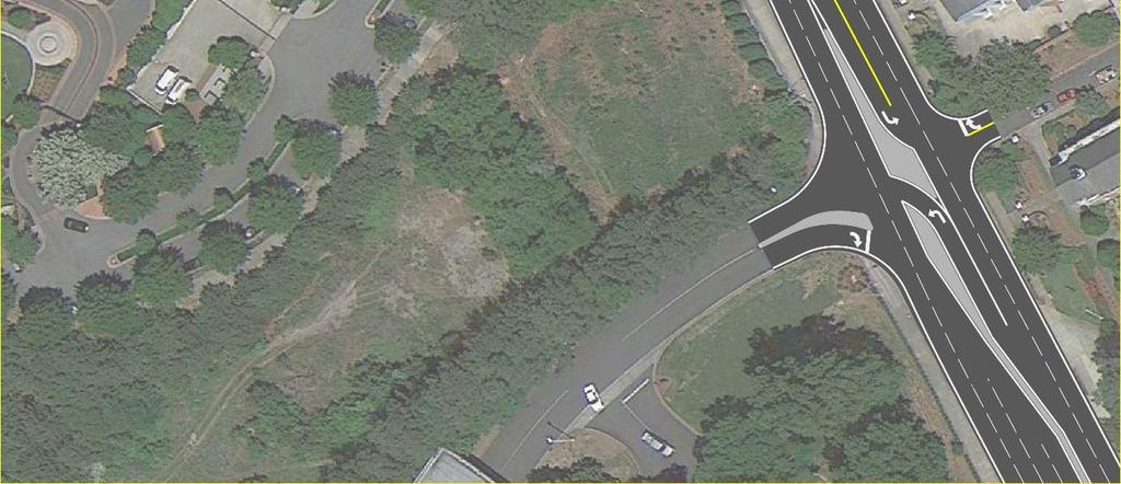
3 Figure 2: Project Data Collection & Evaluation Locations The traffic counts were then balanced and factored to their projected 2017 volumes, which is the opening year of the apartments, mixed use building, and hotel. These balanced, factored volumes were then used to calibrate the BCID mesoscopic travel demand model. This model, which had been developed previously for BCID, includes parcel-level land use and trip generation data, and thus, as part of this project, the land use of the future development parcels was updated to reflect their completion in The model then calculated the corresponding impact of these developments on local traffic volumes to use in evaluating the proposed design alternatives. Figure 3: Proposed Northbound Left Turn Lane at Longleaf Drive Prior to developing the design concepts, a northbound leftturn lane was proposed at the Wieuca Road at Longleaf Drive intersection to provide northbound Wieuca Road access to the new hotel. The turn lane improvement is shown in Figure 3. This left-turn lane can be constructed within the existing curb and requires no new right-of-way. The proposed design adds a median while maintaining southbound access to Wieuca Road Baptist Church and continues right-in, right-out access from Longleaf Drive (west side of Wieuca Road) and the church driveway (east side of Wieuca Road). 3

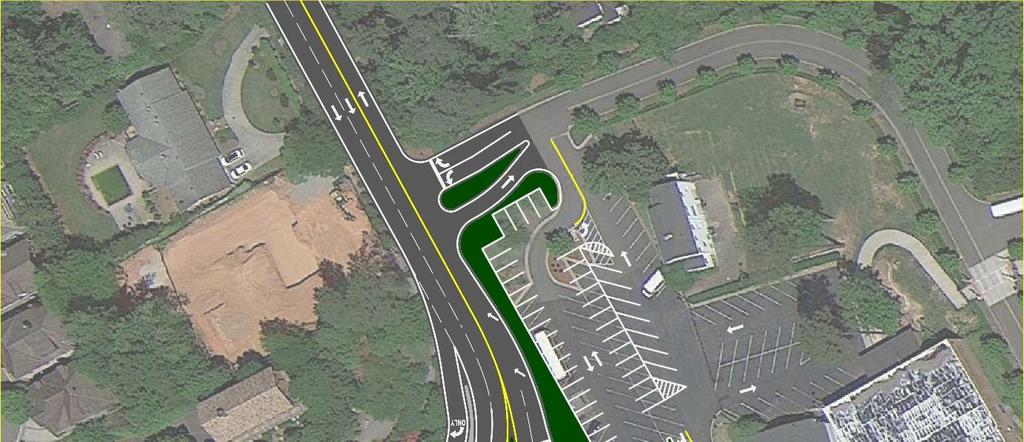
4 Alternatives After determining the projected 2017 traffic volumes, three alternatives for the intersection of Phipps Boulevard at Wieuca Road were developed to improve operations and safety. The alternatives were evaluated with respect to traffic operations, safety improvements, and right-of-way impacts. Alternative 1 Alternative 1 would add an exclusive southbound right-turn lane from Wieuca Road onto westbound Phipps Boulevard, convert Wieuca Road from a two-lane to a three-lane cross section between Phipps Boulevard and Old Ivy Road, and add a protected northbound Wieuca Road left-turn signal phase for safer access to Park Avenue. These modifications, shown in Figure 4, would improve traffic flow on northbound and southbound Wieuca Road north of Phipps Boulevard and improve the safety of northbound left turning vehicles. Alternative 1 would also add a second signal to the Wieuca Road free flow northbound movement to improve pedestrian safety, as shown in Figure 4. Alternative 1 was projected to have minimal roadway and right-of-way impacts and cost approximately $250,000 to construct. Figure 4: Alternative 1 Inset (see Appendix for full page concepts) 4


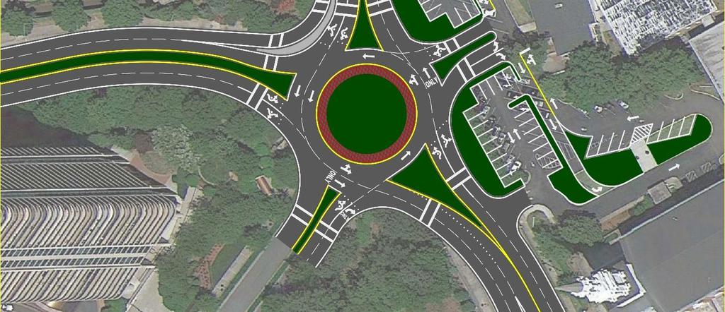
5 Alternative 2 Alternative 2 would widen Wieuca Road between Phipps Boulevard and Old Ivy Road to a 4-lane cross section, as illustrated in Figure 5. At the intersection, Alternative 2 maintains the southbound Wieuca Road right-turn bay proposed in Alternative 1, but modifies the northbound Wieuca Road free-flow lane to include a Hawk pedestrian signal. Alternative 2 would thus increase roadway capacity north of Phipps Boulevard and improve pedestrian safety for those crossing Wieuca Road. The additional capacity added by the fourth Wieuca Road lane north of Phipps Boulevard would, however, increase roadway and right-ofway impacts. Alternative 2 was projected to cost approximately $1 million to construct. Figure 5: Alternative 2 Inset (see Appendix for full page concepts) Alternative 3 Alternative 3 would convert the existing Wieuca Road at Phipps Boulevard signalized intersection into a multi-lane roundabout, as shown in Figure 6. Alternative 3 is projected to provide the greatest congestion and safety benefit with the least impact to Wieuca Road north of Phipps Boulevard. In addition, the roundabout s design mitigates the existing intersection s sight-distance issues and allows pedestrians to safely cross each leg of the roundabout at crosswalks. Alternative 3 is projected to cost approximately $2 million to construct. The roundabout design is typically safer for pedestrian/bicycle crossing, especially on the approach Figure 6: Alternative 3 Inset (see Appendix for full page concept) 5
6 legs. On the departure legs, if needed, a Hawk pedestrian signal or other treatment can be installed in the future if pedestrian crossing is observed to be a safety concern. The costs for any such future signal treatment are not included in the approximately $2 million construction cost. Preferred Alternative Alternative 3 was selected as the preferred alternative by the project stakeholders due to its multitude of potential benefits, which include: The greatest potential for traffic operations improvements as compared to Alternatives 1 and 2 Mitigation of sight distance issues and improved pedestrian safety crossing Wieuca Road Limited impacts to Wieuca Road and residential community north of Phipps Boulevard Ability to serve as a signature gateway to the neighborhoods and control speeds To aid in visualizing how traffic would flow through the roundabout, Vissim micro-simulation models were created to illustrate traffic operations in the 2017 AM and PM peak hours. The models incorporated the projected traffic volumes output by the calibrated travel demand model, which included the impact of the planned developments. These micro-simulation models demonstrated that the roundabout would successfully accommodate the additional traffic volumes projected to be generated by the additional development in all but the most congested PM peak hour of the day. Next Steps With the selection of a roundabout as the preferred alternative, additional work remains to finalize its final design, footprint, and property impacts. Once implemented, the roundabout should provide congestion relief and improved vehicular and pedestrian safety for the residents and employees of North Buckhead. First however, the following steps need to be undertaken as the next steps in this endeavor: Development of traffic projections for design (horizon year) Confirmation of preferred alternative and project limits Development of Concept Layout of Preferred Alternative (color on aerial photography) Preparation of conceptual construction cost estimate Public involvement / public information meetings / stakeholder information meetings Development of survey database including Right of Way and property information Conduct environmental screening Perform Subsurface Utility Engineering (SUE) survey (Quality Level B, as per FHWA recommendation for an urban project) Preliminary Plans including updated cost estimate Right of Way Plans Final Plans including updated cost estimate Permitting Land Disturbance, Lane closures/ Right of Way Permits 6
7 APPENDICES 7

8 Alternative 1: New Southbound Right-turn Lane & Northbound Signal Head Peachtree Rd NE 8


9 Alternative 2: New Southbound Right-turn & Northbound Through Lanes Peachtree Rd NE 9
10 Alternative 3: Multi-approach, Hybrid Roundabout. 10
11 DRAFT 3340 Peachtree Rd NE Cost Benefit Table Alt Description Peak Hour Traffic Issues Potential property and/or environmental impacts Bicycle & Pedestrian Accessibility Preliminary Estimate of Costs* 1 Add SB right turn bay; add signal for NB Wieuca Creates traffic queues on Northbound Wieuca Road Least impact to property; addition of right turn lane across pocket-park frontage Pedestrians have signalized access point to cross northbound Wieuca Approx. $250K 2 Add one lane to Wieuca up to Old Ivy); Restripe NB Wieuca between Phipps and Old Ivy Creates potential weaving issues on Northbound Wieuca Road (between Phipps Boulevard signal & Old Ivy Road intersection) Greatest impact along Wieuca between Phipps and Old Ivy to add turn lane Pedestrians still must cross free-flow northbound lane; HAWK signal recommended Approx. $1M 3 Multi-Lane Roundabout Satisfies peak hour demands Some impact to pocket park, residential tower property Pedestrians cross each leg of roundabout in safer environment Approx. $2M * Very rough cost estimate based on limited project data; it does not include costs for right-of-way or any major environmental / utility impacts; may change as analysis moves further through the screening process 11
Summary of Comments Public Information Meeting Wieuca Road at Phipps Boulevard Intersection Improvements June 7, 2017
 The Public Meeting for the Wieuca Road at Phipps Boulevard Intersection Improvement project was held on at the Wieuca Road Baptist Church, located at 3626 Peachtree Road, Atlanta, GA 30326. There were
Glenn Avenue Corridor Traffic Operational Evaluation
 Glenn Avenue Corridor Traffic Operational Evaluation PREPARED FOR: THE CITY OF AUBURN PREPARED BY: DECEMBER 2007 Glenn Avenue Corridor Study--Auburn, Alabama TABLE OF CONTENTS Introduction... 1 Background
DUNBOW ROAD FUNCTIONAL PLANNING
 DUNBOW ROAD FUNCTIONAL PLANNING Final Report August 3, 216 #31, 316 5th Avenue NE Calgary, AB T2A 6K4 Phone: 43.273.91 Fax: 43.273.344 wattconsultinggroup.com Dunbow Road Functional Planning Final Report
Los Altos Hills Town Council - June 18, 2015 Palo Alto City Council June 22, AGENDA ITEM #2.B Presentation
 Los Altos Hills Town Council - June 18, 2015 Palo Alto City Council June 22, 2015 AGENDA ITEM #2.B Presentation Previous Presentations Los Altos Hills Town Council in May 2014 and February 2015 Palo Alto
Board of Supervisors February 27, 2017
 : Traffic Analysis Results & Draft Conceptual Plan Board of Supervisors February 27, 2017 Transportation Solutions Building Better Communities Presentation Overview Background Summary of Traffic Analysis
Summary: Mercer County Princeton Avenue & Spruce Street Study January 2009
 Summary: Several recent studies have assessed potential development and redevelopment opportunities in the Mercer Crossing area of Trenton, Ewing, and Lawrence. This Princeton Avenue and Spruce Street
REPORT CONCURRENCE. City Manager. The General Manager concurs with the recommendation of this report.
 COUNCIL REPORT Report No. ENG 08-018 Executive Committee Date: May 0, 018 File No: 5400-1 To: From: Subject: Mayor and Council Purvez Irani, Senior Transportation Engineer Bluejay Street Road Improvements
Reference number /VP. Lafayette Downtown Congestion Study - Additional Traffic Analysis
 To James Hinkamp and Tony Coe, City of Lafayette Date January 19, 2017 Copies Reference number 243381/VP From Michael Iswalt and Vanessa Peers File reference 4-05 Subject Lafayette Downtown Congestion
Harrah s Station Square Casino
 Transportation Analysis Harrah s Station Square Casino Pittsburgh, Pennsylvania Submitted To: City of Pittsburgh and Pennsylvania Gaming Control Board Prepared By: DKS Associates GAI Consultants December
5858 N COLLEGE, LLC N College Avenue Traffic Impact Study
 5858 N COLLEGE, LLC nue Traffic Impact Study August 22, 2016 Contents Traffic Impact Study Page Preparer Qualifications... 1 Introduction... 2 Existing Roadway Conditions... 5 Existing Traffic Conditions...
Intersection Traffic Control Feasibility Study
 Intersection Traffic Control Feasibility Study CSAH 9 at CSAH 60 (185th Avenue) Prepared For: Dakota County Transportation Department Western Service Center 14955 Galaxie Avenue, 3rd Floor Apple Valley,
Appendix B. Environmental Resource Technical Memorandum. Assessment on Travel Pattern and Access Impacts
 Appendix B Environmental Resource Technical Memorandum Assessment on Travel Pattern and Access Impacts TECHNICAL MEMORANDUM ENVIRONMENTAL RE-EVALUATION FOR UNION STATION TO OAK CLIFF DALLAS STREETCAR To:
PennDOT ICE Policy An Introduction
 PennDOT ICE Policy An Introduction January 2018 What is Intersection Control Evaluation (ICE)? Purpose: To consistently consider and screen among many proven combinations of geometry and traffic control
180 Grand Avenue, Suite x117 Dowling Associates, Inc.
 180 Grand Avenue, Suite 250 510.839.1742 x117 Oakland, CA 94612 510.839.0871 fax www.dowlinginc.com mbowman@dowlinginc.com Dowling Associates, Inc. Date: Memorandum To: CC: From: Ms. Leah Greenblat City
Princeton Avenue and Spruce Street Transportation and Site Access Enhancements Project
 Princeton Avenue and Spruce Street Transportation and Site Access Enhancements Project Mercer County Planning Division AECOM Transportation (formerly DMJM Harris) January 29, 2009 Agenda Project Status
Chapter 4 Traffic Analysis
 Chapter 4 Traffic Analysis PURPOSE The traffic analysis component of the K-68 Corridor Management Plan incorporates information on the existing transportation network, such as traffic volumes and intersection
#!! "$% ##! &! # '#! % $ #!
 Executive Summary US Highway 16 (US 16) is the primary corridor connecting Rapid City to the Black Hills region. It serves a growing population of commercial and residential traffic, as well as seasonal
Public Information Meeting. Orange Camp Road. Dr. Martin Luther King Jr. Beltway to I-4. Presented by: Volusia County August 2, 2018
 Public Information Meeting Orange Camp Road Dr. Martin Luther King Jr. Beltway to I-4 Presented by: Volusia County August 2, 2018 1 Project Goals To improve the operations and safety for Orange Camp Road
HIGHBURY AVENUE/HAMILTON ROAD INTERSECTION IMPROVEMENTS PUBLIC INFORMATION CENTRE 1 MAY 14, 2015
 HIGHBURY AVENUE/HAMILTON ROAD INTERSECTION IMPROVEMENTS Municipal Class Environmental Assessment PUBLIC INFORMATION CENTRE 1 MAY 14, 2015 ACCESSIBILITY Under the Accessibility Standards 2015 for Customer
Simulating Street-Running LRT Terminus Station Options in Dense Urban Environments Shaumik Pal, Rajat Parashar and Michael Meyer
 Simulating Street-Running LRT Terminus Station Options in Dense Urban Environments Shaumik Pal, Rajat Parashar and Michael Meyer Abstract The Exposition Corridor transit project is a light rail project
2014/2015 BIKE ROUTE PLAN 83 AVENUE PROTECTED BIKE LANE
 About the Project 2014/2015 BIKE ROUTE PLAN The City of Edmonton is planning a major bike route on the south side of Edmonton. This bike route is one part of a plan to provide citizens with transportation
Traffic Circulation Study for Neighborhood Southwest of Mockingbird Lane and Airline Road, Highland Park, Texas
 ARIZONA TEXAS NEW MEXICO OKLAHOMA February 13, 2015 Mr. Meran Dadgostar P.E., R.S. Town of Highland Park 4700 Drexel Dr. Highland Park, Texas 75205 Re: Traffic Circulation Study for Neighborhood Southwest
Project Description Form 8EE
 Project Description Form 8EE Basic Project Information Submitting Jurisdiction/Agency: Town of Dumfries Project Title: Route 1 (Fraley Blvd) Widening: Brady's Hill Road to Dumfries Road Project Location:
4. ENVIRONMENTAL IMPACT ANALYSIS 9. TRANSPORTATION AND TRAFFIC
 4. ENVIRONMENTAL IMPACT ANALYSIS 9. TRANSPORTATION AND TRAFFIC 4.9.1 INTRODUCTION The following section addresses the Proposed Project s impact on transportation and traffic based on the Traffic Study
Corporate. Report COUNCIL DATE: May 25, 1998 NO: R1500 REGULAR COUNCIL. TO: Mayor & Council DATE: April 27, 1998
 R1500 : Traffic Safety at 25 Avenue and 128 Street Intersection Corporate NO: R1500 Report COUNCIL DATE: May 25, 1998 REGULAR COUNCIL TO: Mayor & Council DATE: April 27, 1998 FROM: General Manager, Engineering
Mineral Avenue Corridor Assessment. ITE 2017 Western District Annual Meeting San Diego, CA June 21 st
 Mineral Avenue Corridor Assessment ITE 2017 Western District Annual Meeting San Diego, CA June 21 st Biography - Aaron Heumann, PE, PTOE Currently City of Littleton Transportation Engineering Manager 24
Giles Run Connector Road
 Giles Run Connector Road Laurel Hill Adaptive Reuse Area to Laurel Crest Drive South County Federation Meeting June 14, 2016 History Connector road included in the Laurel Hill Comprehensive Plan amendment
ORANGE COUNTY PUBLIC WORKS TRAFFIC INVESTIGATIONS
 ORANGE COUNTY PUBLIC WORKS TRAFFIC INVESTIGATIONS STAFF REPORT OF: January 6, 2019 SUPERVISORIAL DISTRICT: 5 SUBJECT: LOCATION: INVESTIGATOR: O Neill Drive at Roanoke Drive; Ladera Ranch; TB 922-E6 Clever
Washington St. Corridor Study
 FIGURE 7.17 Bridge Alternatives - Cross Sections 86 Discarded Alternative: Short-Term Bridge Repair Short-term repairs and west bridge span replacement were considered during analysis. Short-term repairs
MEMORANDUM. Our project study area included the following locations:
 MEMORANDUM Date: To: From: Subject: Najib O. Habesch Nick M. Fomenko, PE, PTOE Bushnell Park North Traffic Assessment BETA Project #: 4461 As part of our contract to undertake the design of the Bushnell
WISCONSIN AVENUE EXTENSION SECOND PUBLIC INFORMATION MEETING. March 28, 2017
 WISCONSIN AVENUE EXTENSION SECOND PUBLIC INFORMATION MEETING March 28, 2017 STUDY AREA N MEETING AGENDA Introductions Study Background Alternatives Studied Recommended Alternative Discussion STUDY BACKGROUND
133 rd Street and 132 nd /Hemlock Street 132 nd Street and Foster Street MINI ROUNDABOUTS. Overland Park, Kansas
 133 rd Street and 132 nd /Hemlock Street 132 nd Street and Foster Street MINI ROUNDABOUTS Overland Park, Kansas September 1, 2017 TABLE OF CONTENTS 1. INTRODUCTION... 1 2. LITERATURE REVIEW... 1 3. CONCEPT
CITY OF OTTAWA ROADWAY MODIFICATION APPROVAL UNDER DELEGATED AUTHORITY
 RMA-2015-ATM-038 CITY OF OTTAWA ROADWAY MODIFICATION APPROVAL UNDER DELEGATED AUTHORITY DATE: April 22, 2015 SUBJECT Approval of Roadway Modifications Recommended through an Area Traffic Management Study
Welcome to the Quebec Alternatives Analysis Public Meeting
 Welcome to the Public Meeting Please sign in. Public Comment Please fill out a comment card and tell us what you think. Check back or comment any time at: www.quebecalternatives.com Project Area Technical
TAKOMA METRO STATION
 TKOM METRO STTION Traffic nalysis Technical Memorandum Station Planning in Support of Joint evelopment Job No. 13-FQ165-LN-2 November 213 WSHINGTON METROPOLITN RE TRNSIT UTHORITY (WMT) Takoma Metro Station
King Soopers #116 Thornton, Colorado
 Traffic Impact Study King Soopers #116 Thornton, Colorado Prepared for: Galloway & Company, Inc. 1.0 EXECUTIVE SUMMARY King Soopers #116, a grocery marketplace anchored commercial development, is proposed
Roundabout Evaluations in Virginia: US 15/US 50 Gilberts Corner, VA SR 106/SR 634 Prince George County, VA
 Roundabout Evaluations in Virginia: US 15/US 50 Gilberts Corner, VA SR 106/SR 634 Prince George County, VA VDOT & FHWA Roundabout Workshop September 17, 2013 Chris Tiesler, PE Presentation Outline US 15/US
LOOP 360 IMPROVEMENT STUDY
 LOOP 360 IMPROVEMENT STUDY Overview and Preliminary Analysis August 2015 1 STUDY PROCESS 2 Study Background Loop 360 serves a wide range of users, including residents, businesses, bicyclists, and commuters
Route 7 Corridor Study
 Route 7 Corridor Study Executive Summary Study Area The following report analyzes a segment of the Virginia State Route 7 corridor. The corridor study area, spanning over 5 miles in length, is a multi
APPENDIX G: INTERSECTION NEEDS AT OKEECHOBEE BOULEVARD
 APPENDIX G: INTERSECTION NEEDS AT OKEECHOBEE BOULEVARD INTERSECTION NEEDS AT SR 7 and OKEECHOBEE BOULEVARD SR 7 Extension Project Development and Environment (PD&E) Study From Okeechobee Boulevard (SR
Proposed Action, Purpose and Need Technical Memorandum
 Proposed Action, Purpose and Need Technical Memorandum MoPac (State Loop 1) Intersections, Austin District From North of Slaughter Lane to South of La Crosse Avenue CSJ: 3136-01-015 Travis County, Texas
Traffic Impact Study WestBranch Residential Development Davidson, NC March 2016
 Traffic Impact Study WestBranch Residential Development Davidson, NC March 216 TRAFFIC IMPACT STUDY FOR THE WestBranch Residential Development LOCATED IN DAVIDSON, NC Prepared For: Lennar Carolinas, LLC
Gateway Transportation Study
 Gateway Transportation Study Amherst, Massachusetts SUBMITTED TO University of Massachusetts Amherst Town of Amherst SUBMITTED BY Vanasse Hangen Brustlin, Inc. Watertown, Massachusetts March 213 Back of
Recommendations. Central Salem Mobility Study
 Central Salem Mobility Study The Central Salem Mobility Study evaluated a range of multimodal transportation issues affecting downtown Salem, including circulation, access, and safety for people traveling
Traffic Impact Analysis Chatham County Grocery Chatham County, NC
 Chatham County Grocery Chatham County, NC TABLE OF CONTENTS 1. INTRODUCTION... 1 1.1. Location and Study Area... 1 1.2. Proposed Land Use and Access... 2 1.3. Adjacent Land Uses... 2 1.4. Existing ways...
TRAFFIC IMPACT STUDY COMPREHENSIVE UPDATE TOWN OF THOMPSON S STATION, TENNESSEE PREPARED FOR: THE TOWN OF THOMPSON S STATION
 TRAFFIC IMPACT STUDY COMPREHENSIVE UPDATE TOWN OF THOMPSON S STATION, TENNESSEE PREPARED FOR: THE TOWN OF THOMPSON S STATION Transportation Consultants, LLC 1101 17 TH AVENUE SOUTH NASHVILLE, TN 37212
US 278 Corridor Concept Presentation. Avondale Estates Intersection Improvement/Roundabout and Road Diet Feasibility Study March 19, 2015
 US 278 Corridor Concept Presentation Avondale Estates Intersection Improvement/Roundabout and Road Diet Feasibility Study March 19, 2015 Thanks to our Partners Atlanta Regional Commission Georgia Department
Transportation Impact Study for Abington Terrace
 Transportation Impact Study for Abington Terrace Abington Township, Montgomery County, PA Sandy A. Koza, P.E., PTOE PA PE License Number PE059911 Prepared by McMahon Associates, Inc. 425 Commerce Drive,
Welcome. If you have any questions or comments on the project, please contact:
 Welcome This drop-in public open house is intended to provide information about the Bay Street bike lanes project. This project proposes a dedicated cycling facility along Bay Street between Aberdeen Avenue
FINAL DESIGN TRAFFIC TECHNICAL MEMORANDUM
 FINAL DESIGN TRAFFIC TECHNICAL MEMORANDUM July 2014 FINAL (SR 43) Project Development and Environment Study From State Road 60 (Adamo Drive) to I-4 (SR 400) Hillsborough County, Florida Work Program Item
Appendix D: Concept Screening
 Concept Description Concept #1 Route 288 Roadway Widening This concept consists of constructing a third lane on northbound and southbound Route 288 between Powhite Parkway and US 360. This improvement
DEPARTMENT OF ENVIRONMENTAL SERVICES. North Harrison Street (Lee Highway to Little Falls Road) Comparative Analysis. Prepared for:
 Comparative Analysis. Prepared for:") DEPARTMENT OF ENVIRONMENTAL SERVICES North Harrison Street (Lee Highway to Little Falls Road) Comparative Analysis Prepared for: Arlington County Department of Environmental Services 2100 Clarendon Boulevard,
DEPARTMENT OF ENVIRONMENTAL SERVICES North Harrison Street (Lee Highway to Little Falls Road) Comparative Analysis Prepared for: Arlington County Department of Environmental Services 2100 Clarendon Boulevard,
Pine Hills Road Pedestrian/Bicycle Safety Study Board of County Commissioners Work Session
 Pine Hills Road Pedestrian/Bicycle Safety Study Board of County Commissioners Work Session February 20, 2018 Meeting Agenda Study Overview Existing Conditions Access Management Potential Gateway Features
BETHEL ROAD AND SEDGWICK ROAD CORRIDOR STUDY
 DRAFT PLAN City Council Meeting August 14, 2017 STUDY AREA Sedgwick Corridor State Route 160, principal arterial with Class 3 access management designation, commuter and freight route, connection to SR
TRAFFIC IMPACT ANALYSIS
 TRAFFIC IMPACT ANALYSIS FOR THE CHAMPAIGN UNIT#4 SCHOOL DISTRICT PROPOSED HIGH SCHOOL (SPALDING PARK SITE) IN THE CITY OF CHAMPAIGN Final Report Champaign Urbana Urbanized Area Transportation Study 6/24/2014
Marina Loft (DRC 51-R-12)
") Marina Loft (DRC 51-R-12) traffic study prepared for: Cymbal Development OCtober 2012 Traf Tech October 1, 2012 Mr. Asi Cymbal - President Cymbal Development 3470 North Miami Avenue Upper Suite Miami,
Marina Loft (DRC 51-R-12) traffic study prepared for: Cymbal Development OCtober 2012 Traf Tech October 1, 2012 Mr. Asi Cymbal - President Cymbal Development 3470 North Miami Avenue Upper Suite Miami,
2014/2015 BIKE ROUTE PLAN 83 AVENUE PROTECTED BIKE LANE
 About the Project The City of Edmonton is planning a major bike route on the southside of Edmonton. The Strathcona Bike Route will connect the communities of Strathcona, Garneau and the University area,
Welcome! San Jose Avenue Open House August 25, 2015
 Welcome! San Jose Avenue Open House August 25, 2015 Vision Zero The City and County of San Francisco adopted Vision Zero San Francisco Vision Zero High Injury Network as a policy in 2014, committing an
GARLAND ROAD/GASTON AVENUE/ GRAND AVENUE INTERSECTION IMPROVEMENT STUDY
 MEETING OF AFFECTED PROPERTY OWNERS AND STAKEHOLDERS GARLAND ROAD/GASTON AVENUE/ GRAND AVENUE INTERSECTION IMPROVEMENT STUDY CSJ 0009-02-067 Meeting Agenda 1 2 3 4 5 6 7 8 9 10 Opening Remarks State Representative
Traffic Study North Shore School District 112
 Traffic Study North Shore School District 112 Proposed Expansion of Northwood Junior High School Prepared By: May 1, 2015 1. Introduction Kenig, Lindgren, O Hara, Aboona, Inc. (KLOA, Inc.) has been retained
Shockoe Bottom Preliminary Traffic and Parking Analysis
 Shockoe Bottom Preliminary Traffic and Parking Analysis Richmond, Virginia August 14, 2013 Prepared For City of Richmond Department of Public Works Prepared By 1001 Boulders Pkwy Suite 300, Richmond, VA
THIS PAGE LEFT BLANK INTENTIONALLY
 GA SR 25 Spur at Canal Road Transportation Impact Analysis PREPARED FOR GLYNN COUNTY, GEORGIA 1725 Reynolds Street, Suite 300 Brunswick, Georgia 31520 PREPARED BY 217 Arrowhead Boulevard Suite 26 Jonesboro,
2016 Church Street Access Study. 100 Clinton Square 126 North Salina Street, Suite 100 Syracuse, NY
 2016 Church Street Access Study 100 Clinton Square 126 North Salina Street, Suite 100 Syracuse, NY 13202 www.smtcmpo.org Syracuse Metropolitan Transportation Council Final Report February 23, 2016 This
Wyldewood Estates. Pre-Application Public Engagement Summary of Issues and Responses
 Wyldewood Estates Pre-Application Public Engagement Summary of Issues and Responses March 2016 Executive Summary Morguard Residential Properties has been thoughtfully planning the redevelopment of Wyldewood
6.4 RECOMMENDED IMPROVEMENTS
 6.4 RECOMMENDED IMPROVEMENTS 6.4.1 Williston Road Recommendations While all alternatives would be an improvement over existing conditions, Alternative 3B is recommended over the others because it provides
BLUE SEA VILLAGE MER BLEUE 2159 MER BLEUE ROAD OTTAWA, ONTARIO TRANSPORTATION IMPACT ASSESSMENT. Prepared for: Ontario Limited.
 BLUE SEA VILLAGE MER BLEUE 2159 MER BLEUE ROAD OTTAWA, ONTARIO TRANSPORTATION IMPACT ASSESSMENT Prepared for: 2534189 Ontario Limited April 6, 2018 117-668 TIA Report_2.doc D. J. Halpenny & Associates
Central Avenue Bikeway Traffic and Safety Impact Assessment
 FEBRUARY 2018 Lead Agency: San Diego Association of Governments (SANDAG) 401 B Street, Suite 800 San Diego, CA 92101 Contact: Chris Carterette, AICP, Project Manager 619.699.7319 chris.carterette@sandag.org
5.0 Roadway System Plan
 Southwest Boise Transportation Study Page 16 5.0 Roadway System Plan The Roadway System Plan outlines roadway improvements in the Initial Study Area. It forecasts future deficiencies on the arterial system,
EXHIBIT R1. Neighborhood Cul-de-Sac Implementation
 Neighborhood Cul-de-Sac Implementation The traffic study conducted for the Talaria project analyzed the amount of project traffic expected to use local, residential streets immediately north of the project
M-58 HIGHWAY ACCESS MANAGEMENT STUDY Mullen Road to Bel-Ray Boulevard. Prepared for CITY OF BELTON. May 2016
 M-58 HIGHWAY ACCESS MANAGEMENT STUDY Prepared for CITY OF BELTON By May 2016 Introduction Missouri State Highway 58 (M-58 Highway) is a major commercial corridor in the City of Belton. As development has
Date: September 7, Project #: Re: Spaulding Youth Center Northfield, NH Property. Traffic Impact Study
 To: Ms. Susan C. Ryan Spaulding Youth Center 72 Spaulding Road Northfield, NH 03276 Date: September 7, 2017 Project #: 52455.00 From: Robin Bousa Director of Transportation Systems Re: Spaulding Youth
1. What is the Doran Street and Broadway/Brazil Grade Separation Project (Project)?
?") 1. What is the Doran Street and Broadway/Brazil Grade Separation Project (Project)? The Los Angeles County Metropolitan Transportation Authority (Metro) is evaluating the development of a grade separation
1. What is the Doran Street and Broadway/Brazil Grade Separation Project (Project)? The Los Angeles County Metropolitan Transportation Authority (Metro) is evaluating the development of a grade separation
ROUNDABOUT SOLUTIONS FOR COMPLEX TRAFFIC ENVIRONMENTS
 ROUNDABOUT SOLUTIONS FOR COMPLEX TRAFFIC ENVIRONMENTS Author/Presenter s Name: Mike Mailing Address: 728 East Beaton Drive, West Fargo, ND 58078 Telephone Number: 701 271 4879 E-Mail: Mike.@kljeng.com
Terwillegar Drive Expressway Draft Concept Plan
 Terwillegar Drive Expressway Draft Concept Plan Anthony Henday Drive to Whitemud Drive November 28 5:00-8:00 p.m. December 1 10:00 a.m. - 3:00 p.m. Let s Talk Today you can: Learn about the new direction
Introduction Roundabouts are an increasingly popular alternative to traffic signals for intersection control in the United States. Roundabouts have a
 HIGH-CAPACITY ROUNDABOUT INTERSECTION ANALYSIS: GOING AROUND IN CIRCLES David Stanek, PE and Ronald T. Milam, AICP Abstract. Roundabouts have become increasingly popular in recent years as an innovative
Water Street Promenade. Engineering and Design Services. Public Information Meeting No. 2. Education / Infrastructure / Innovation. Maplewood Avenue &
 Public Information Meeting No. 2 Water Street Promenade Maplewood Avenue & Engineering and Design Services Adjacent Areas July 16,2014Portsmouth, NH May 10, 2016 Education / Infrastructure / Innovation
Caltrans Sloat Boulevard Pedestrian Safety Project Response to Community Questions, Comments & Concerns
 Caltrans Sloat Boulevard Pedestrian Safety Project Response to Community Questions, Comments & Concerns Revised: May 10, 2016 The California Department of Transportation (Caltrans) is planning various
Pedestrian & Bicycle Safety Innovations & Applications
 Pedestrian & Bicycle Safety Innovations & Applications County Engineers Association of Maryland Spring, 2017 Conference May 25, 2017 George Branyan Pedestrian Program Coordinator District Department of
Public Information Meeting. Warren County Pathway Corridor Project September 27, 2018
 Public Information Meeting Warren County Pathway Corridor Project September 27, 2018 Why are we here? Introduce Study Hear concerns and Ideas Obtain input on preliminary Alternatives Previous Study (2008)
List of Attachments. Location Map... Site Plan... City of Lake Elsinore Circulation Element... City of Lake Elsinore Roadway Cross-Sections...
 List of Attachments Exhibits Location Map... Site Plan... City of Lake Elsinore Circulation Element... City of Lake Elsinore Roadway Cross-Sections... Existing Lane Geometry and Traffic Controls... Existing
Appendix C. NORTH METRO STATION AREA TRAFFIC IMPACT STATEMENT 88th Avenue Station
 Appendix C NORTH METRO STATION AREA TRAFFIC IMPACT STATEMENT 88th Avenue Station Prepared for: Regional Transportation Department and URS Corporation as part of the North Metro EIS David Evans and Associates,
Dr. M.L. King, Jr. Street North Complete Streets Resurfacing Opportunities HOUSING, LAND USE, AND TRANSPORTATION COMMITTEE MARCH 22, 2018
 Dr. M.L. King, Jr. Street North Complete Streets Resurfacing Opportunities HOUSING, LAND USE, AND TRANSPORTATION COMMITTEE MARCH 22, 2018 What s Happening The City plans to mill and resurface Dr. M.L.
Financial Project ID No(s).: and ETDM No(s).: and 14181
.: and ETDM No(s).: and 14181") Palm Beach Metropolitan Planning Organization (MPO) Presentation I-95 at Boynton Beach Boulevard Interchange and I-95 at Gateway Boulevard Interchange Project Development and Environment Study Palm Beach
Palm Beach Metropolitan Planning Organization (MPO) Presentation I-95 at Boynton Beach Boulevard Interchange and I-95 at Gateway Boulevard Interchange Project Development and Environment Study Palm Beach
Alexander Ikefuna City of Charlottesville Director of Neighborhood and Development Services
 To: CC: From: Alexander Ikefuna City of Charlottesville Director of Neighborhood and Development Services Jeanette Janiczek, City of Charlottesville UCI Program Manager, NDS Tony Edwards, City of Charlottesville
CITY OF FRANKLIN, TENNESSEE. Columbia Avenue. Widening & Improvements Project. Public Meeting May 16, 2017
 CITY OF FRANKLIN, TENNESSEE Columbia Avenue Widening & Improvements Project Public Meeting May 16, 2017 Agenda 6:00 6:30 Formal Presentation 6:30 8:00 Town Hall Forum City of Franklin Columbia Avenue Alternatives
Gene Dillon Elementary School Traffic Study Division Street Site
 To: From: Dr. James Hess, Superintendent Jordan Schwarze, PE, Senior Engineer Matt Pacyna, PE, Senior Associate Date: March 30, 2016 Subject: Gene Dillon Elementary School Traffic Study reet Site Memorandum
Highway 111 Corridor Study
 Highway 111 Corridor Study June, 2009 LINCOLN CO. HWY 111 CORRIDOR STUDY Draft Study Tea, South Dakota Prepared for City of Tea Sioux Falls Metropolitan Planning Organization Prepared by HDR Engineering,
Citizen Advisory Group Meeting #8 May 5, Welcome. Today s meeting will focus on: Land Use & Transportation CHARLOTTEPLANNING.
 Citizen Advisory Group Meeting #8 May 5, 2010 Welcome. Today s meeting will focus on: Land Use & Transportation CHARLOTTEPLANNING.ORG Meeting Agenda Handouts: o Meeting Agenda o Summary of East Seventh
South End Transportation Study. Public Meeting. January 31, 2019 Welcome. Public Meeting. January 10, 2018 WELCOME
 Public Meeting January 31, 2019 Welcome Public Meeting January 10, 2018 WELCOME What You Will Hear Tonight All ideas presented are options currently under consideration Study Team found no single solution
Public Works Committee Meeting Richard E. Mastrangelo Council Chamber November 20, 2017
 Public Works Committee Meeting Richard E. Mastrangelo Council Chamber November 20, 2017 Purpose of Meeting Why are we here? Project Recap/Updates Project Limits/Segments Road Diet Concept Lessons Learned
Station 1: Street & Sidewalk Upgrades
 Station 1: Street & Sidewalk Upgrades Existing no left turn; Potential left turn arrow, see Circulation Study boards for more information Thru-lane guidance Improved lead-in green bike lane 17TH ST CASTRO
Operational Comparison of Transit Signal Priority Strategies
 Operational Comparison of Transit Signal Priority Strategies Revision Submitted on: November, 0 Author: Adriana Rodriguez, E.I Assistant Engineer Parsons Brinckerhoff 0 South Orange Avenue, Suite 00 Orlando,
MEMORANDUM. DATE March 1, 2012 TO Town of Milton Mark Abbott, Seth Asante, and Efi Pagitsas Boston Region MPO Staff
 MEMORANDUM DATE March 1, 212 TO Town of Milton FROM RE Mark Abbott, Seth Asante, and Efi Pagitsas Boston Region MPO Staff FFY 211 Safety and Operations Analyses at Selected Boston Region MPO Intersections:
David DiPierro, John Amberson. Steering Committee Meeting #4 Overview
 IBI GROUP 18401 Von Karman Avenue Suite 110 Irvine CA 92612 USA tel 949 833 5588 fax 949 833 5511 ibigroup.com Memorandum To/Attention Steering Committee Members Date February 17, 2016 From IBI Group Project
State Street and Pierce Park Lane Intersection Concept Report
 State Street and Pierce Park Lane Intersection Prepared for September 2017 Prepared by CITATION Parametrix. 2017. State Street & Pierce Park Lane Intersection. Prepared by Parametrix, Boise, ID. September
Offset Single Point Interchange I-25 at Rio Bravo Boulevard Albuquerque, New Mexico
 Offset Single Point Interchange I-25 at Rio Bravo Boulevard Albuquerque, New Mexico INSTITUTE OF TRANSPORTATION ENGINEERS 2016 WESTERN DISTRICT MEETING JULY 11, 2016 7/11/2016 1 Project Vicinity Map 7/11/2016
Norfolk Tide LRT System Weaving Transit in Downtown Norfolk
 Rail-Volution 2010 Weaving Transit into Existing Communities Norfolk Tide LRT System Weaving Transit in Downtown Norfolk Dan Meyers, AICP URS, Planning Manager Minneapolis, Minnesota Norfolk Tide LRT Alignment
DIMARCO CANANDAIGUA PROPERTIES HOUSING PROJECT CANANDAIGUA, ONTARIO COUNTY, NEW YORK
 TRAFFIC IMPACT STUDY FOR THE DIMARCO CANANDAIGUA PROPERTIES HOUSING PROJECT CANANDAIGUA, ONTARIO COUNTY, NEW YORK MARCH 14, 2017 PREPARED FOR: 1950 Brighton Henrietta Town Line Rd Rochester, NY 14623 PREPARED
Figure 5A: Diagram of Crashes, May 2005 to May 2008 (Part 1)
") Figure 5A: Diagram of Crashes, May 2005 to May 2008 (Part 1) Canal Pointe Boulevard Study - March 2015 10 Table of Contents INTRODUCTION... 1 EXISTING CONDITIONS... 1 Existing Roadway Conditions and Controls...
Figure 5A: Diagram of Crashes, May 2005 to May 2008 (Part 1) Canal Pointe Boulevard Study - March 2015 10 Table of Contents INTRODUCTION... 1 EXISTING CONDITIONS... 1 Existing Roadway Conditions and Controls...
3.0 PROJECT DESCRIPTION
 The following section of the Draft EIR contains a description of the proposed Elk Grove Boulevard/SR 99 Interchange Modification project, consistent with the requirements of CEQA Guidelines Section 15124.