Hermitage Foreshore Track
|
|
|
- Dominic Wells
- 5 years ago
- Views:
Transcription


1 Hermitage Foreshore Track 1 Hr 2.2 km One way Moderate track 123m The Hermitage Foreshore Walk is a wonderful way to explore Sydney Harbour from the perspective of South Head. This walk starts from Nielsen Park and follows a well maintained track along the narrow strip of harbour-side bushland to Bayview Hill Rd. Along the way, you will visit some secluded beaches and visit the historic Strickland House. A great walk exploring the history and natural beauty while enjoying a new perspective of the city. 3 Maps, text & images are copyright wildwalks.com Thanks to OSM, NASA and others for data used to generate some map layers. 1m Sydney Harbour National Park 21m

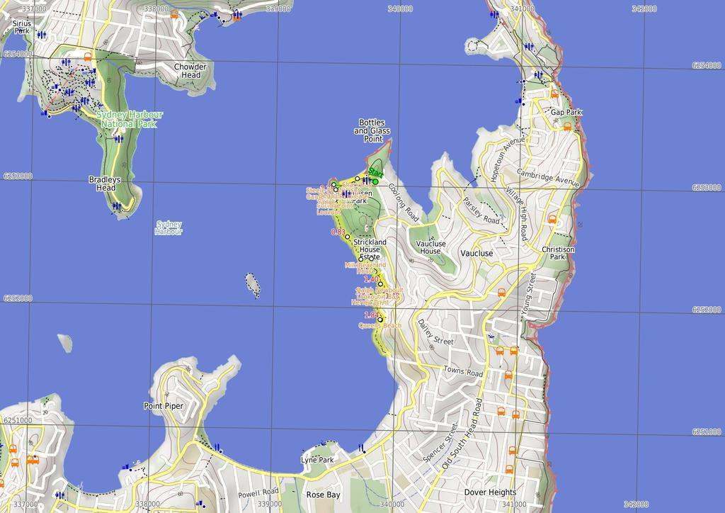
2 Shark Bay Located at the northern end of Nielsen Park, this beach faces north across Sydney Harbour. The sandy beach offers a swimming net enclosure, public toilets and change rooms, showers and is a popular place for people to simply relax. The beach is a focal point of Nielsen Park and also boasts a cafe. Protected by the harbour, there is no surf at this beach. The beach is not patrolled. This is a lovely spot, with natural shade not far from the beach. Nielsen Park Cafe Open 8-5 daily, this historic cafe offers inside seating and a range of meals, including breakfast, sandwiches and hot food. This is one of a number of buildings in Nielsen Park which are available for functions. For further enquiries, contact More info. Degaussing range This degaussing range, found at Steele Point, was constructed in 196 and is still operated by the Royal Australian Navy today. Degaussing is the process of removing (or at least reducing) a magnetic field. This degaussing range services four areas in the harbour (about 5m from the building), where metal ships passing over will be automatically de-magnetised. Why? Mostly to prevent the triggering of seabed mines. More info. Steele Point Gun Emplacement Construction of this initial emplacement took about three years and was completed in The sandstone pit once had a steel dome (to protect from shells) and was part of a series of gun emplacements protecting from the threat of invasion. Today, you will find a series of tall sandstone channels and the circular pit where the main gun once stood. A set of un-railed steps leads into the pit - please take care in the area, as the pit is not fenced. Steele Point Cottage Why not make a weekend of it? Built in 188, this one-time gunners' barracks has been restored as a one bedroom getaway. Managed by NPWS, you can hire this cottage (found on Steele Point) from $33 per night (two night min). Great for a romantic weekend away for two. More info. Steele Point Lookout Informally named, this fenced lookout is the most northern lookout on the Hermitage Foreshore Walk. There are great harbour views to the city in this well-shaded spot. Before You walk Bushwalking is fun and a wonderful way to enjoy our natural places. Sometimes things go bad, with a bit of planning you can increase your chance of having an ejoyable and safer walk. Before setting off on your walk check 1) Weather Forecast (BOM Metropolitan District) 2) Fire Dangers (Greater Sydney Region, unknown) 3) Park Alerts (Sydney Harbour National Park) 4) Research the walk to check your party has the skills, fitness and equipment required 5) Agree to stay as a group and not leave anyone to walk solo Think before you TREK The 'Think before you TREK' program developed by NSW Police & NPWS promotes the benefits of planning ahead for your bushwalking trip by using an easy to remember acronym: T R E K Take adequate supplies of food, water, navigation and first aid equipment. Register your planned route and tell friends and family when you expect to return. Emergency beacon (PLB's) should be carried on walks with significant gaps in mobile coverage (check terrain profile). Keep to your planned route and follow the map and walking trails. Topo Maps The maps provided on wildwalks are helpful, but there are times where you may need maps covering a broader area. Maps that cover this walk include; 1:25 Map Series:9132N SYDNEY HEADS 1:1 Map Series:913 SYDNEY Grade This walk has been graded using the AS The overall grade of the walk is dertermined by the highest classification along the whole track. 3 Length Time Quality of track Grade 3/6 Moderate track 2.2 km One way 1 Hr Formed track, with some branches and other obstacles (3/6) Signs Clearly signposted (1/6) Experience Required Weather Infrastructure No experience required (1/6) Storms may impact on navigation and safety (3/6) Generally useful facilities (such as fenced cliffs and seats) (1/6)
3 Are you ready to have fun? Please ensure you and your group are well prepared and equipped for all possible hazards and delays. Check park closures, weather information and Fire Danger Rating before setting out. Optional side trips and alternate routes noted are not included in this walks overall grade, length or time estimate. Please allow extra time for resting and exploring areas of interest. The authors, staff and owners of wildwalks take care in preparing this information but will not accept responsibility for any inconvenience, loss or injury you may experience. Please take care, have fun - Happy Walking. Getting there You can get to Greycliffe Ave Car Park (gps: , ) by car or bus. Car: There is free parking available. You can get back from End of Bayview Hill Rd (gps: , ) by car or bus. Car: There is free parking available. Find up to date and more information inlcuding; travel directions, weather, park closures and walker feedback at Greycliffe Ave Car Park (2 m ) From the lower end of the car park on Greycliffe Ave, this walk heads around the gate and along the sealed path (driveway) towards the water, passing the 'Sydney Harbour National Park' sign. After?5m, the path leads to a four-way intersection just past the garbage bins. Continue straight: From the intersection, this walk heads towards the water following the wide path. The path soon bends left (near the toilet block, on the right) and heads behind the beach, past the large information sign. Soon the path heads over the 'Dressing Pavilion' tunnel and,?5m later, comes to the front of the Nielsen Park Cafe with it's great water views..2 Shark Bay Located at the northern end of Nielsen Park, this beach faces north across Sydney Harbour. The sandy beach offers a swimming net enclosure, public toilets and change rooms, showers and is a popular place for people to simply relax. The beach is a focal point of Nielsen Park and also boasts a cafe. Protected by the harbour, there is no surf at this beach. The beach is not patrolled. This is a lovely spot, with natural shade not far from the beach..2 Nielsen Park Cafe Open 8-5 daily, this historic cafe offers inside seating and a range of meals, including breakfast, sandwiches and hot food. This is one of a number of buildings in Nielsen Park which are available for functions. For further enquiries, contact More info..2 Nielsen Park Cafe (15 m ) Continue straight: From Nielsen Park Cafe, this walk heads the short distance along the path in front of the cafe and behind the beach (keeping the water to your right). The path heads past the 'William Albert Notting' and 'Niels R.W. Nielsen, MLA' memorial (on your left) to soon find a four-way intersection (at the base of some steps) at the eastern end of Shark Bay. Continue straight: From the intersection, this walk follows the 'Hermitage Foreshore Walking Track' sign up the stairs. The path soon flattens out though the open grassy area, and heads up a few more steps to come to an intersection with a road (driveway) next to the fenced degaussing range (on your right)..35 Degaussing range This degaussing range, found at Steele Point, was constructed in 196 and is still operated by the Royal Australian Navy today. Degaussing is the process of removing (or at least reducing) a magnetic field. This degaussing range services four areas in the harbour (about 5m from the building), where metal ships passing over will be automatically de-magnetised. Why? Mostly to prevent the triggering of seabed mines. More info..35 Optional sidetrip to Steele Point Gun Emplacement (5 m ) Turn sharp right: From the intersection, this walk heads up the driveway, keeping the degaussing range fence just to your left. At the end of the driveway, the walk heads across the grass to find the Steele Point Gun Emplacement just behind the degaussing range. Beware of the unfenced drop into the emplacement. At the end of this side trip, retrace your steps back to the main walk then Turn right..35 Steele Point Gun Emplacement Construction of this initial emplacement took about three years and was completed in The sandstone pit once had a steel dome (to protect from shells) and was part of a series of gun emplacements protecting from the threat of invasion. Today, you will find a series of tall sandstone channels and the circular pit where the main gun once stood. A set of un-railed steps leads into the pit - please take care in the area, as the pit is not fenced..35 Degaussing range (3 m ) Veer right: From the intersection, this walk heads along the road, keeping the degaussing range to your right. Just after the 'Steele Point Cottage' sign, the road comes to an intersection marked with a large 'Hermitage Foreshore Walk' sign, in the grassy clearing on your right..38 Steele Point Cottage Why not make a weekend of it? Built in 188, this one-time gunners' barracks has been restored as a one bedroom getaway. Managed by NPWS, you can hire this cottage (found on Steele Point) from $33 per night (two night min). Great for a romantic weekend away for two. More info..38 Steele Point int (6 m ) Veer right: From the intersection, this walk follows the 'Hermitage Foreshore Walk' sign down the sandstone stairs (with handrail). At the bottom of the stairs, the track leads past a 'Surviving in the city' information sign and â ˆ25m later, comes to an unnamed, fenced lookout with good water and city views..44 Steele Point Lookout Informally named, this fenced lookout is the most northern lookout on the Hermitage Foreshore Walk. There are great harbour views to the city in this well-shaded spot..44 Steele Point Lookout (39 m 9 mins) Turn left: From the lookout, this walk follows the NPWS arrow up the steps (keeping the water to your right). The track leads past a couple of handrails and a sandstone overhang and, at the bottom of some steps, comes to a minor intersection, marked with warning sign (on your right). (This short side track leads to an unfenced view of the harbour - heed the warning). The walk continues along the main track, past another handrail section with more views and â ˆ9m later, the track heads down some steps to the foreshore with some interesting rock formations. From here, the walk follows the handrail past the small inlet and along the coastline. After a further â ˆ15m, the track comes to a faint intersection marked with another 'Surviving in the City' information sign..83 Surviving in the City sign int (25 m 6 mins) Veer right: From the intersection, this walk heads down a few steps, keeping the water to your right. The track soon leads through a fairly weedy section, with great harbour views. The track then leads up some steps over a rise, coming to a minor intersection near a gap in the black wire fence. (The track to the left leads into the northern end of the Strickland House property). Here, the walk turns right and heads down the hill, where the track then tends left and down some steps onto the northern end of Milk Beach. 1.8 Milk Beach Milk Beach is a small, secluded, sandy beach in Sydney Harbour National Park, on the inside of South Head. In the 'back yard' of Strickland House, this beach is a memorable spot along the Hermitage Foreshore Walk. The beach is about 5m wide and faces south-east. The views across the water to the city and to Shark Island are great. A seat on the grassy clearing behind the beach makes a very inviting offer to sit and enjoy for a while. This is also a great place to get the toes wet. 1.8 Milk Beach (1 m 2 mins) Veer left: From Milk Beach, this walk heads to the southeastern end of the beach (the far end, with the water on your right), and heads up the steps to the bench seat and a large 'Hermitage Foreshore Walk' sign behind the beach. Here, the walk turns right and heads up the stone stairs and past a NPWS arrow marker to find a large grassy clearing and some picnic tables at the back of Strickland House Strickland House First established in 1913 and named after Sir Gerald Strickland (Governor of NSW ), Strickland House was a women's convalescent home until Today, the house and gardens are hired out for private functions, however, if just walking through, this is a great spot to take a break, enjoy the views and rest from the walk. For more information, phone Strickland House on (2) Strickland House picnic area (1 m 2 mins) Continue straight: From the Strickland House picnic area, this walk heads along the open grassy area, keeping the water to your right. The walk heads past a 'Hermitage Foreshore Walk - Tingara Beach' sign?35m before coming to the end of the lawn and a gap in the fence. The walk heads through the gap in the fence and,?2m later, comes to an intersection at the top of Tingara Beach track (on your right) Optional sidetrip to Tingara Beach (3 m ) Turn right: From the intersection, this walk heads downhill along the rocky steps, directly away from the house. The track soon leads to Tingara Beach. At the end of this side trip, retrace your steps back to the main walk then Turn right Top of Tingara Beach track (12 m ) Continue straight: From the intersection, this walk heads along the path, keeping the house up to your left. After?25m, the track comes to a minor intersection (with steps on the right that lead down to a small beach with good harbour views). From here, the walk continues along the main track for another?2m to a three-way intersection (with sandstone steps on the left that lead up to Tingara Ave). Continue straight: From the intersection, this walk heads down the few sandstone steps (keeping the water to your right) and then heads through a grassy section behind the houses. The track soon heads down some steps (with a handrail) then mostly up the next set of stairs to turn right onto a large rock with a handrail. Soon, the walk heads past a sandstone wall and down the brick then sandstone steps, to find a bench seat and fenced Ralph Newboult Lookout. 1.4 Ralph Newboult Lookout This lookout boasts great views as well as being home to a bench seat and memorial to Ralph Newboult. The lookout is a shaded spot with great views across the harbour to the city. Ralph was a keen bushwalker who lead walks
4 most Wednesdays for the National Parks Association of NSW. His sudden death whilst walking on 8 November 2 was a great shock to the many who walked with him and especially to his family. More info. follows the concrete path which soon bends left and leads to the end of Bayview Hill Road. 1.4 Ralph Newboult Lookout (8 m ) Continue straight: From Ralph Newboult Lookout (keeping the water on your right), this walk follows the railing around to the left and heads up the steps. The track leads directly behind the houses then down the brick steps to follow the track behind Hermit Bay beach to a shady spot just before the small bridge, near some interesting rock formations Hermit Bay beach This secluded beach in Hermit Bay (just north of Hermit Point) is home to a 4m-wide, east facing sandy beach. Behind the beach is the Hermitage Foreshore walk track and a few houses through the trees. The beach is lined with some natural sandstone sculptures of interesting form and is a quiet place to enjoy the wide harbour views Hermit Bay Beach (11 m 2 mins) Veer right: From Hermit Bay Beach, this walk crosses the small bridge and follows the foreshore, keeping the water to your right. The walk heads through the grassy clearing with a few picnic tables and sandstone boat pens to come to the signposted 'Hermit Point' Hermit Point Hermit Point hosts a grassy open area and is surrounded by a sandstone sea wall. The sea wall has been shaped to host some boat pens, a launch and a timber wharf. The area is now protected as part of the Sydney Harbour National Park. Here, you will find a number of picnic tables, a small sandstone cave, natural shade and some great water views. The headland, bay and ultimately the Hermitage Foreshore Walk, derive their names from the large home behind this point. The Hermitage was originally built in 184 by Alexander Dick, then in the 187's, Edward Mason Hunt undertook some significant renovations, turning it into a Victorian Rustic Gothic house Hermit Point (25 m 5 mins) Veer left: From Hermit Point, this walk follows the concrete path up the hill (keeping the water to your right). Soon, the walk turns left and heads up the steps. The track then leads behind some houses, over a small creek and down some steps to a three-way intersection (above Queens Beach). Veer right: From the intersection, this walk heads down the steps towards the beach. The track then comes to a boardwalk, a 'Hermitage Foreshore Walk - Queens Beach' sign and a short set of steps leading down to the beach Queens Beach Queens Beach is a small, 5m wide sandy beach that faces west, near Queens Ave Vaucluse. The beach has the Hermitage Foreshore walk running behind it. The beach is protected from the ocean surf and is not patrolled. There are great views across the harbour to the city and Harbour Bridge. A quiet spot, providing an excuse to enjoy the view and splash the feet Queens Beach (33 m 8 mins) Continue straight: From behind Queens Beach, this walk follows the timber boardwalk, keeping the water and beach to your right. The walk then follows the handrail past some more harbour views then up a series of sandstone steps. About 4m from the top of the steps, the track passes behind the fenced Convent of the Sacred Heart Cemetery. A further?35m beyond the cemetery, the walk passes a minor intersection (the steps on the right lead down to some old sandstone foundation at the water's edge with good views). The walk continues along the main track and after?9m,
5
6 Powered by TCPDF ( Summary navigation sheet for the Hermitage Foreshore Track km From Up/Dwn Length Initial directions (Use full tracknotes and maps for more detail). Greycliffe Ave Car Park , (GR Sydney Heads, 39853) -7 2 m From the lower end of the car park on Greycliffe Ave, this walk heads around the gate and along the sealed path (driveway) towards the water, passing the 'Sydney Harbour National Park' sign..2 Nielsen Park Cafe , (GR Sydney Heads, 39653) m Continue straight: From Nielsen Park Cafe, this walk heads the short distance along the path in front of the cafe and behind the beach (keeping the water to your right)..35 Degaussing range , (GR Sydney Heads, 39553) -7 5 m Optional sidetrip to Steele Point Gun Emplacement. Turn sharp right: From the intersection, this walk heads up the driveway, keeping the degaussing range fence just to your left..35 Degaussing range , (GR Sydney Heads, 39553) 4 3 m Veer right: From the intersection, this walk heads along the road, keeping the degaussing range to your right..38 Steele Point int , (GR Sydney Heads, ) m Veer right: From the intersection, this walk follows the 'Hermitage Foreshore Walk' sign down the sandstone stairs (with handrail)..44 Steele Point Lookout , (GR Sydney Heads, ) m 9 mins Turn left: From the lookout, this walk follows the NPWS arrow up the steps (keeping the water to your right)..83 Surviving in the City sign int , (GR Sydney Heads, ) m 6 mins Veer right: From the intersection, this walk heads down a few steps, keeping the water to your right. 1.8 Milk Beach , (GR Sydney Heads, ) m 2 mins Veer left: From Milk Beach, this walk heads to the south-eastern end of the beach (the far end, with the water on your right), and heads up the steps to the bench seat and a large 'Hermitage Foreshore Walk' sign beh Strickland House picnic area , (GR Sydney Heads, ) m 2 mins Continue straight: From the Strickland House picnic area, this walk heads along the open grassy area, keeping the water to your right Top of Tingara Beach track , (GR Sydney Heads, ) -5 3 m Optional sidetrip to Tingara Beach. Turn right: From the intersection, this walk heads downhill along the rocky steps, directly away from the house Top of Tingara Beach track , (GR Sydney Heads, ) m Continue straight: From the intersection, this walk heads along the path, keeping the house up to your left. 1.4 Ralph Newboult Lookout , (GR Sydney Heads, ) m Continue straight: From Ralph Newboult Lookout (keeping the water on your right), this walk follows the railing around to the left and heads up the steps Hermit Bay Beach , (GR Sydney Heads, ) m 2 mins Veer right: From Hermit Bay Beach, this walk crosses the small bridge and follows the foreshore, keeping the water to your right Hermit Point , (GR Sydney Heads, ) m 5 mins Veer left: From Hermit Point, this walk follows the concrete path up the hill (keeping the water to your right) Queens Beach , (GR Sydney Heads, ) m 8 mins Continue straight: From behind Queens Beach, this walk follows the timber boardwalk, keeping the water and beach to your right.
Currie Rd to Davidson Park
 Currie Rd to Davidson Park 3 hrs 7.2 km One way Moderate track 28m Starting at Currie Rd in Forestville, this walk follows Middle Harbour to Davidson Park, under Roseville Bridge. There are two optional
Hunters Hill to Epping Road
 Hunters Hill to Epping Road 2 hrs 30 mins 5.5 km One way Moderate track 154m An enjoyable walk through lower sections of the Lane Cove National Park, this walk features plenty of mangroves next to the
Campbell Drive to Snapper Point
 Campbell Drive to Snapper Point 1 hr 45 mins 4.2 km One way Experienced only 135m This walk follows the Coast Track to Frazer Beach, along the Geebung and (overgrown) Grass Tree Tracks. From the northern
Echo Point to Leura Forest via Three Sisters and Giant Stairs loop
 Echo Point to Leura Forest via Three Sisters and Giant Stairs loop 3 hrs 3.8 km Circuit Hard track 512m This walk starts from the popular Echo Point, in Katoomba, and winds down to the base of the Three
Sid Pulsford Walk. 175m. 33m. 1 hr 45 mins 4.1 km One way. Hard track 118m. Gosford LGA
 Sid Pulsford Walk 1 hr 5 mins.1 km One way Hard track 118m Sid Pulsford Walk explores the ridge top of Kincumber Mountain, from Honeman's Rock to Green Point. The walk mostly follows wide management trails.
Wattamolla to Big Marley Beach
 Wattamolla to Big Marley Beach 4 hrs 10.4 km Circuit Moderate track 4m This walk is an excellent loop which takes in both the coast and the heathy inland of Royal National Park. Nearly the whole walk has
The Foreshore Walk. 24m. 1m Lake Macquarie LGA. 1 hr 15 mins 2.9 km One way. Hard track 81m
 The Foreshore Walk 1 hr 15 mins 2.9 km One way Hard track 81m This walk traverses the coastline of the Green Point reserve. By following a variety of tracks and occasionally traveling inland through eucalyptus
Little Digger Track. 68m. 1 Hr 2.2 km One way. Moderate track 93m. Moores Creek Reserve
 Little Digger Track Hr 2.2 km One way Moderate track 93m This walk follows Moores Creek through several reserves in east Roseville and East Lindfield. The track is named after Australia's 7th Prime Minster,
Wallarah Coastal Walk
 Wallarah Coastal Walk 3 hrs 8.3 km Return Hard track 247m This walk starts at Caves Beach and travels south along the coastline, until reaching the Pinney s Headland Lookout. There are many opportunities
Wentworth Falls Conservation Hut Loop
 Wentworth Falls Conservation Hut Loop 3 hrs Hard track 6.7 km Circuit 4 341m This scenic walk from Wentworth Falls Station, winds along the Nature Trail to Conservation Hut, then drops into the magnificent
Balmoral Beach to The Spit
 Balmoral Beach to The Spit 2 hrs 30 mins.3 km One way Hard track 85m This walks follows the coast from Balmoral to the Spit and across Spit Bridge. There are some alternate tracks to consider at high-tides,
Rail to River Walk. 3 hrs. Hard track 7.5 km Circuit. 222m
 Rail to River Walk 3 hrs Hard track 7.5 km Circuit 4 222m This walk is a great one from Chatswood Station to the Lane Cove River National Park. The walk descends through the vegetated bushland which fills
Morgans Creek to Padstow
 Morgans Creek to Padstow 2 hrs 45 mins 8 km One way Moderate track 3 144m This pleasant walk starts from the Morgans Creek park, at Henry Lawsons Drive, and follows the Georges River past the Boomerang
Little Digger Track to Davidson Reserve and Lyrebird Circuit
 Little Digger Track to Davidson Reserve and Lyrebird Circuit 4 hrs 3 mins 11.5 km One way Hard track 4 47m Exploring both the eastern and western sides of Middle Harbour Creek, this walk follows the Little
Carrington Park to Leura Forest and pass loop
 Carrington Park to Leura Forest and pass loop 3 hrs Hard track 4.8 km Circuit 4 674m This walk is a fantastic way to see Leura Forest. The walk descends from Carrington Park, visiting Leura Forest and
Waterfall to Heathcote
 Waterfall to Heathcote 5 hrs Hard track 10.8 km One way 4 467m This walk explores the heart of Heathcote National Park, and is easily accessed with a train station at either end. Although relatively close
Popes Glen, Pulpit Rock, Govetts Leap and Braeside Walk
 Popes Glen, Pulpit Rock, Govetts Leap and Braeside Walk 8 hrs Hard track 13.6 km Circuit 4 1068m This large circuit walk, from Popes Glen to Pulpit Rock, Govetts leap and along the Braeside Track, passes
Heathcote to Engadine via Audley
 Heathcote to Engadine via Audley 6 hrs 3 mins 5 km One way Hard track 4 635m Covering a large section of central Royal National Park, this walk goes through the heath and scrub along a well managed and
Govetts Leap Loop. 1065m. 909m Blue Mountains National Park. 4 hrs 30 mins 8.7 km Circuit. Hard track 380m
 Govetts Leap Loop 4 hrs 30 mins 8.7 km Circuit Hard track 380m This walk, from Blackheath Train Station, is a fantastic way to see some of the iconic areas of the Blue Mountains in the Blackheath area.
Spit Bridge to Middle Head Forts
 Spit Bridge to Middle Head Forts 2 hrs 30 mins 6.3 km One way Hard track 4 181m This scenic walk takes you from the Spit Bridge, along the coast to explore the Middle Head Forts. There are a few alternate
Epping to Pennant Hills Station (via Lane Cove River)
") Epping to Pennant Hills Station (via Lane Cove River) 3 hrs 5 mins 8.4 km One way Hard track 249m This walk, from Epping to Pennant Hills Station, is a great way to see the upper Lane Cove River Valley.
Epping to Pennant Hills Station (via Lane Cove River) 3 hrs 5 mins 8.4 km One way Hard track 249m This walk, from Epping to Pennant Hills Station, is a great way to see the upper Lane Cove River Valley.
Mackerel Beach, West Head Loop
 Mackerel Beach, West Head Loop 5 hrs 8.6 km Circuit Hard track 422m The Mackerel Beach, West Head Loop is a walk which explores a large part of the West Head. The journey starts and finishes with a ferry
De Burghs Bridge to Fullers Bridge
 De Burghs Bridge to Fullers Bridge 2 hrs 3 mins Hard track 6 km One way 2m 4 Following the Lane Cove River, this walk mostly follows a section of the Great North Walk and is well maintained and signposted.
Hornsby Blue Gum Walk
 Hornsby Blue Gum Walk 3 hrs Hard track 6.7 km Circuit 4 374m This delightful loop is one of the prettiest and most popular walks in the Hornsby area. Going from an environment of ferns and clear bushland
Epping to Eastwood Station (via Lane Cove River)
") Epping to Eastwood Station (via Lane Cove River) hrs 45 mins 10.2 km One way Moderate track 189m Epping to Eastwood, via Lane Cove River, is the longer route through the bush between the stations. This
Epping to Eastwood Station (via Lane Cove River) hrs 45 mins 10.2 km One way Moderate track 189m Epping to Eastwood, via Lane Cove River, is the longer route through the bush between the stations. This
The Basin Track and Mackerel Track
 The Basin Track and Mackerel Track 3 hrs 5.9 km Circuit Hard track 226m This walk is a great way to see some popular areas in Ku-ring-gai Chase National Park. The walk from West Head Rd travels to The
Katoomba Falls Circuit
 Katoomba Falls Circuit hr 5 mins.5 km Circuit Hard track 59m For those looking for a walk involving more than simple boardwalk, this trail winding through the temperate rain forest could be just the thing.
Taronga Wharf to Chowder Bay
 Taronga Wharf to Chowder Bay 2 hrs 4.4 km One way Moderate track 246m Starting at Taronga Wharf, this walk passes many icons of Sydney, including Taronga Zoo, HMAS Sydney Mast, Chowder Bay. The walk also
Mackerel Beach and Resolute Loop
 Mackerel Beach and Resolute Loop 3 hrs 5.4 km Circuit Hard track 384m This walk is another great walk in Ku-ring-gai Chase National Park, accessed by ferry. From the Mackerel Beach wharf, this walk uses
Rail to River and Stringybark Creek Reserve Walk
 Rail to River and Stringybark Creek Reserve Walk 4 hrs Hard track 11.2 km Circuit 4 302m This walk begins in the busy city of Chatswood and soon enters the nearby bushland around the Lane Cove River. The
Bouddi Coastal Walk. 5 hrs. Hard track 8.1 km One way. 364m
 Bouddi Coastal Walk 5 hrs Hard track 8.1 km One way 4 364m This is one of the longer walks in the Bouddi National Park and it is rich in scenery. The walk follows the coastline with many side trips to
Woolwich Wharf to Boronia Park
 Woolwich Wharf to Boronia Park 2 hrs 5.8 km One way Moderate track 175m Going through the streets of Hunters Hill, this walk is on the first segment of the Great North Walk. The majority of the walk is
National Pass from Wentworth Falls to Conservation Hut
 National Pass from Wentworth Falls to Conservation Hut 3 hrs Hard track 3.6 km One way 739m Starting at Wentworth Falls picnic area, this scenic and historic walk explores many waterfalls, lookouts and
Scenic World to Echo Point
 Scenic World to Echo Point 1 hr 15 mins 2.1 km One way Moderate track 192m This is one of the most popular tourist walks in the Katoomba area. The walk follows the cliffs along a well maintained and signposted
Callicoma Loop. 174m. 98m. 2 hrs. Hard track 5.1 km Circuit. 153m
 Callicoma Loop 2 hrs Hard track 5.1 km Circuit 153m This great circuit walk passes through some really nice forest around the fringe of Cherrybrook. Highlights of the walk include some beautiful rock overhangs
Berowra to Mt Kuring-gai
 Berowra to Mt Kuring-gai 4 hrs 30 mins 9.4 km One way Hard track 4 551m From the ridges above Cowan Creek, this walk takes in some great lookouts (especially around Mt Kuringgai) as well as enjoying an
Green Point Circuit Walk
 Green Point Circuit Walk 3 hrs 7.7 km Circuit Hard track 269m This walk visits all of the popular locations in Green Point Reserve, as well as some of the lesser-visited areas inland. Taking in Sea Eagle
Teralba to Charlestown Park track head
 Teralba to Charlestown Park track head 4 hrs 30 mins 13.3 km One way Moderate track 3 220m This section of the Great North Walk starts from the Teralba train station and winds down and around the edge
Dead Horse Gap Loop track
 Dead Horse Gap Loop track 4 hrs 30 mins Hard track 9.8 km Circuit 144m 4 This walk starts with a ride up the Kosciuszko Express Chairlift. There is an opportunity to eat at Australia's highest restaurant,
Sphinx, Warrimoo and Bobbin Head tracks
 Sphinx, Warrimoo and Bobbin Head tracks 4 hrs 9.6 km Circuit Moderate track 499m This great walk starts at the Sphinx Memorial and loops around via Cowan Creek, exploring diverse environments as it changes
Middle Harbour Creek Loop
 Middle Harbour Creek Loop 5 hrs 45 mins 15.1 km Circuit Experienced only 5 570m This walk explores the upper reaches of Middle Harbour Creek, starting and ending at the great parklands at Davidson Park,
Patonga to Woy Woy. 5 hrs 45 mins 15.5 km One way. Hard track. 497m
 Patonga to Woy Woy 5 hrs 45 mins 15.5 km One way Hard track 4 497m This walk explores a variety of environments from the shore line and coastal cliffs near Patonga, to the dry, rocky and open ridge line.
Upper Rumbalara circuit
 Upper Rumbalara circuit 1 hr 30 mins 3.3 km Circuit Hard track 176m A great circuit walk, covering most of the walking tracks and sights in the upper section of the Rumbalara Reserve. There is some really
De Burgs Bridge to Thornleigh station
 De Burgs Bridge to Thornleigh station 3 hrs 45 mins 9.7 km One way Hard track 4 363m This walk follows a section of the Great North Walk, starting from De Burghs bridge. The walk winds north west, through
Under and Over Cliff Walk
 Under and Over Cliff Walk 4 hrs 9.4 km Circuit Moderate track 576m This walk from Wentworth Falls Station is a fantastic way to see a large majority of the Wentworth Falls cliffline. The track winds under
Dubbo Gully and Ten Mile Hollow Circuit (via Clares Bridge)
") Dubbo Gully and Ten Mile Hollow Circuit (via Clares Bridge) 2 Days Hard track 24.3 km Circuit 4 1117m This two day (or ten hour) walk follows several historic roads, now closed to traffic. Starting with
Dubbo Gully and Ten Mile Hollow Circuit (via Clares Bridge) 2 Days Hard track 24.3 km Circuit 4 1117m This two day (or ten hour) walk follows several historic roads, now closed to traffic. Starting with
Roseville to Macquarie Park
 Roseville to Macquarie Park 3 hrs 3 mins 8.8 km One way Hard track 4 29m This walk starts at Roseville station and explores the streets and alleyways of Roseville before joining the main spine of the Great
Epping to Gordon Station
 Epping to Gordon Station 4 hrs 15 mins 11.7 km One way Hard track 4 365m This walk, from Epping Station to Gordon Station, passes below the homes which sit on the hills high above the Lane Cove River.
Wentworth Falls Station Loop (Undercliff Walk)
") Wentworth Falls Station Loop (Undercliff Walk) 4 hrs 3 mins Hard track 8.9 km Circuit 658m 4 This walk passes some stunning waterfalls and views into the Jamison Valley, following the cliff edges around
Wentworth Falls Station Loop (Undercliff Walk) 4 hrs 3 mins Hard track 8.9 km Circuit 658m 4 This walk passes some stunning waterfalls and views into the Jamison Valley, following the cliff edges around
Federal Pass Walking Track
 Federal Pass Walking Track 5 hrs Hard track 8 km One way 4 989m This classic trail follows along the base of the cliffs from Leura to the Golden Stairs, passing many of the more popular sights of the Katoomba
Gordon to Chatswood Station
 Gordon to Chatswood Station 4 hrs 30 mins 12.2 km One way Hard track 4 381m This walk is a great way to get into the bush without being far from civilisation. The walk wanders through untouched valleys
Glenbrook and Euroka Circuit
 Glenbrook and Euroka Circuit 2 Days 16.6 km Circuit Experienced only 790m This two day circuit, returning to Glenbrook Station, is a scenic walk which passes many of the tourist attractions within the
Blackheath Station to Junction Rock Loop (via Grand Canyon and Popes
 Blackheath Station to Junction Rock Loop (via Grand Canyon and Popes 8 hrs 30 mins 18.2 km Circuit Hard track 4 1254m This circuit starts in Blackheath and heads down into the Grand Canyon and Rodriguez
Lane Cove Tourist Park River Circuit
 Lane Cove Tourist Park River Circuit 5 hrs 12 km Circuit Hard track 383m This walk follows a large section of Lane Cove River. The walk follows the Riverside Walking track up the Lane Cove River to De
North Ryde Fairyland circuit
 North Ryde Fairyland circuit 2 hrs 30 mins Hard track 6.9 km Circuit 193m 4 Starting at North Ryde train station this walk explores a stretch of the Lane Cove River, visiting the historic Fairlylands Pleasure
Wentworth Falls Loop. 893m. 665m. 6 hrs 10.2 km Circuit. Hard track 1093m. Blue Mountains National Park
 Wentworth Falls Loop 6 hrs 1.2 km Circuit Hard track 193m This is a great walk, both in size and spectacular views. The walk makes its way from Wentworth Falls train station and drops off the plateau,
Echo Point to Leura Forest Circuit
 Echo Point to Leura Forest Circuit 3 hrs 4.8 km Circuit Hard track 588m Forming a circuit around the cliffs and then the valley floor, this is a walk more then capable of convincing a walker of the beauty
Wentworth Falls Station Loop
 Wentworth Falls Station Loop 5 hrs 3 mins 9.5 km Circuit Hard track 4 13m The Wentworth Falls Station Loop takes in most of the upper tracks around Wentworth Falls. There are many scenic views near the
Thornleigh to Hornsby
 Thornleigh to Hornsby 4 hrs Hard track 10.2 km One way 4 526m Starting at Thornleigh station you walk through suburban streets for a short while before diving into the bush at the southern end of Berowra
Sphinx to Mt Kuring-gai
 Sphinx to Mt Kuring-gai 4 hrs 45 mins 1.7 km One way Hard track 673m This walk starts at the Sphinx War Memorial and follows some well maintained and popular walking tracks down to Cowan Creek. Enjoy the
Spit Bridge to Manly (Manly Scenic Walkway)
") Spit Bridge to Manly (Manly Scenic Walkway) 3 hrs 45 mins 9.1 km One way Moderate track 349m The Spit to Manly walk is a classic bushwalk on Sydney's Northern Beaches. The walk follows a well-maintained
Spit Bridge to Manly (Manly Scenic Walkway) 3 hrs 45 mins 9.1 km One way Moderate track 349m The Spit to Manly walk is a classic bushwalk on Sydney's Northern Beaches. The walk follows a well-maintained
Charlestown Park trackhead to Newcastle station
 Charlestown Park trackhead to Newcastle station 5 hrs 30 mins 12.1 km One way Hard track 4 287m This section of the Great North Walk starts from the Charleston Park track head and winds through the streets
Gosford to Lisarow. 202m
 Gosford to Lisarow 4 hrs 3 mins Hard track 11.3 km One way 4 479m This walk is a great way to explore the ridge-top bushland between Gosford and Lisarow. Passing through Rumbalara and Katandra Reserves,
Taronga Zoo to Spit Bridge
 Taronga Zoo to Spit Bridge 5 hrs Hard track 1.4 km One way 4 41m This is a scenic and culturally rich walk with views over Sydney Harbour and many interesting heritage buildings along the way. The start
The Coast Track. 2 Days. Hard track 27.4 km One way. 1351m
 The Coast Track 2 Days Hard track 27.4 km One way 4 1351m Heading south, this walk covers the coastline of the Royal National Park and can truly only be described as amazing. With breathtaking coastal
Cape Banks Circuit. 50m. 2m Botany Bay National Park. 3 hrs 7.3 km Circuit. Hard track 190m
 Cape Banks Circuit 3 hrs 7.3 km Circuit Hard track 19m This Cape Banks Circuit has a lot to offer and is thoroughly recommended. The walking travels over beaches, through coastal forest and across exposed
Rumbalara Explorer. 158m. 5m Rumbalara Reserve. 2 hrs 45 mins 6.1 km Circuit. Hard track 326m
 Rumbalara Explorer 2 hrs 5 mins 6.1 km Circuit Hard track 326m Pretty well the grand tour of the Rumbalara Reserve, this walk takes in much of the great scenery the reserve has to offer. The walk covers
Bobbin Head Loop. 166m. 0m Ku-ring-gai Chase National Park. 5 hrs 12.9 km Circuit. Hard track 619m
 Bobbin Head Loop 5 hrs 12.9 km Circuit Hard track 619m This great circuit walk enjoys a variety of landscapes in Ku-ring-gai Chase National Park. The walk starts at the historic Sphinx war memorial and
Manly to Seaforth Oval
 Manly to Seaforth Oval 5 hrs 45 mins 13.7 km One way Moderate track 3 624m This walk follows the Manly to Spit Scenic Walkway, then continues past The Spit Bridge to Seaforth Oval. The walk provides magnificent
Scenic world to Three Sisters Loop via Furber Steps
 Scenic world to Three Sisters Loop via Furber Steps 5 hrs 5.8 km Circuit Hard track 722m This walk starts from the popular Scenic World, in Katoomba, and winds down the Furber steps into the Jamison Valley,
Chatswood to Epping Station
 Chatswood to Epping Station 6 hrs Hard track 16.3 km One way 4 533m This walk, from Chatswood to Epping, is a long but enjoyable walk along the Lane Cove valley. The walk mostly follows the Lane Cove River
Faulconbridge to Blaxland
 Faulconbridge to Blaxland 2 Days Experienced only 15.2 km One way 5 693m This two-day walk, or very solid one-day walk, takes you from station to station, through lush, scenic forest in the lower Blue
Bouddi Ridge and Coastal Walk
 Bouddi Ridge and Coastal Walk 2 Days Hard track 27 km Circuit 4 126m This overnight walk takes in the majority of the magnificent Bouddi National Park. The walk starts from the pleasant Putty Beach camping
Narrabeen Lagoon Trail (from Middle Creek)
") Narrabeen Lagoon Trail (from Middle Creek) 2 hrs 30 mins 8.6 km Circuit Very easy 1 105m The Narrabeen Lagoon Trail is a wonderful and accessible walk on the Northern Beaches of Sydney. The trail is used
Narrabeen Lagoon Trail (from Middle Creek) 2 hrs 30 mins 8.6 km Circuit Very easy 1 105m The Narrabeen Lagoon Trail is a wonderful and accessible walk on the Northern Beaches of Sydney. The trail is used
Light to Light Walk 2 days
 Light to Light Walk 2 days 2 Days Hard track 3.9 km One way 4 794m Over two days, this classic walk explores the coast from Boyd Tower to the Green Cape Lighthouse in the south. Hegartys Bay Camp is over
Six Foot Track. 1212m
 Six Foot Track 3 Days 44.8 km One way Hard track 4 2066m This classic walk takes you from Katoomba to Jenolan Caves via a historic horse route. The walk travels mainly along well-maintained service tracks
Harbour Bridge to Taronga Zoo
 Harbour Bridge to Taronga Zoo 4 hrs 9.8 km One way Moderate track 389m On this walk, you will explore much of the foreshore linking Milsons Point Station to Taronga Zoo Ferry wharf. The walk is mostly
Sydney to Thornleigh via Lane Cove Tourist Park
 Sydney to Thornleigh via Lane Cove Tourist Park 2 Days 33 km One way Hard track 4 1114m This overnight walk starts from the Obelisk in Macquarie Park, Sydney, at the official start of the Great North Walk.
NEWLANDS CORNER AND ST MARTHAS
 NEWLANDS CORNER AND ST MARTHAS 10k CIRCULAR ROUTE 2½-3HRS GU4 8SE From Newlands Corner on the North Downs just outside Guildford, you can enjoy one of the most beautiful panoramas of quintessential English
Directions for Day 1: Colwood To Metchosin
 Colwood-Metchosin Page 1 of 8 Directions for Day 1: Colwood To Metchosin Start: Royal Roads University, Birds of a Feather B&B, or at Esquimalt Lagoon Finish: Your accommodation in Metchosin Time: 4-5
Montmorency Park Facility Audit
 Montmorency Park Facility Audit Document number 000215 Client / Site Location Auditor Tennis Victoria 2 Dobson Road Montmorency VIC 3094 Andrew Sodomaco Audit date 04 Sep 2015 Site summary Total number
Winterfold Wood. point your feet on a new path. In Brief
 point your feet on a new path Winterfold Wood Distance: 8½ km=5¼ miles Region: Surrey Author: Schwebefuss Refreshments: Windmill Inn, Peaslake after the walk moderate walking with many gradients Date written:
THE WELLDIGGERS ARMS, HESWORTH AND FITTLEWORTH TRAIL
 THE WELLDIGGERS ARMS, HESWORTH AND FITTLEWORTH TRAIL 5.5 miles Circular 3 hours 041017 Challenging Terrain A 300-year-old pub turned country-inn on the edge of the South Downs National Park, The Welldiggers
RILLINGTON TO MALTON by Tania Dickinson
 RILLINGTON TO MALTON by Tania Dickinson This walk takes you from the Vale of Pickering up on to the Wold scarp, before dropping down again through the pretty village of Settrington and joining the Centenary
SELF GUIDED TOURING ROUTE
 SELF GUIDED TOURING ROUTE Things to see and places to go on the loop from Orbost to Marlo, Cape Conran, Cabbage Tree and back to Orbost (or onwards to Cann River) V6 April 2017 This guide should be read
Hammer Vale and Linchmere Common
 point your feet on a new path Hammer Vale and Linchmere Common Distance: 9 km=5½ miles or 6 km=3¾ miles easy walking with one steep section Region: Hampshire, West Sussex Author: Botafuego Refreshments:
Harlington - Sharpenhoe - Pulloxhill
 Harlington - Sharpenhoe - Pulloxhill ID: 3676, Distance: 8 miles, Height gain: 140 Metres, Map: Explorer 193 Luton & Stevenage, Contributor: Dennis Jeanes Duration: 3 Hours 27 Mins Features Church,Great
Shepherdswell - Dover
 Shepherdswell - Dover The North Downs Way > Shepherdswell to Dover Introduction This part of the path is slightly different in character from most other parts of the path since it spends much of the time
Dorridge & District Residents Association A Walk Along The Green Belt From Dorridge to Catherine-de-Barnes
 Dorridge & District Residents Association A Walk Along The Green Belt From Dorridge to Carine-de-Barnes The starting section of this walk through open fields would be destroyed by building of motorway
Detailed maps, and portaging and camping information follow.
 Overview of Bain route. The launch site is at Davidson Lake, just before the Manitoba/Ontario border. You can do a loop if you leave a vehicle at Tulabi Lake (at the canoe route parking lot). The road
Approximate distance: 10 miles For this walk we ve included OS grid references should you wish to use them. Start. End
 Approximate distance: 10 miles For this walk we ve included OS grid references should you wish to use them. 2 3 Start End 1 N W E S Reproduced by permission of Ordnance Survey on behalf of HMSO. Crown
Beautiful Walks from the Blue Ball Inn
 Walk No. 7 COAST AND VALLEY WALK Countisbury, Glenthorne, County Gate, Brendon, Rockford and Wilsham 10 MILES APPROX. Walking time 5 hours approx. (not including breaks)> OS Sheet 64/74 Lynton and Lynmouth.
Telfer Reserve Facility Audit
 Telfer Reserve Facility Audit Document number 000218 Client / Site Location Auditor Tennis Victoria Greenwood Drive Bundoora VIC 3083 Andrew Sodomaco Audit date 11 Sep 2015 Site summary Total number of
Masson Hill. Walk. Approximately 4 km. Moderate Walk Begins from Matlock Railway Station
 Masson Hill Walk Approximately 4 km Moderate Walk Begins from Matlock Railway Station TOWN WALKS Masson Hill walk is approx. 4 km. It can be walked in a couple of hours or so. Enjoy your walk and the beautiful
EXECUTIVE SUMMARY Callan Park accommodates travel from a wide range of transport modes, including walking, cycling, bus and light rail.
 TRANSPORT AND ACCESS EXECUTIVE SUMMARY Callan Park accommodates travel from a wide range of transport modes, including walking, cycling, bus and light rail. Whilst there are some walking facilities within
Burke Road North Tennis Facility Audit
 Burke Road North Tennis Facility Audit Document number 000209 Client / Site Location Auditor Tennis Victoria Off the Boulevard East Ivanhoe VIC 3079 Andrew Sodomaco Audit date 30 Aug 2015 Site summary
Walk 7: Watchet to washford
 Walk 7: Watchet to washford Length: Moderate - 7.5 miles / 12 km Good For: Theme: History Duration: 2-3 hours depending on speed of walking Notes: This is a moderate to difficult walk in places, with steps,
ST. AGNES. you cannot put a time limit on beauty.
 ST. AGNES CIRCULAR WALKS AROUND There are many enjoyable and picturesque walks around St. Agnes most are signposted and are featured on the St. Agnes Mini-guide map. Because most of our footpaths are in
GUIDE YOUR WAY - 30KM. Event Maps bywild Women On Top
 GUIDE YOUR WAY - 30KM Event Maps bywild Women On Top Melbourne Coastrek 2016 Overview Map Point Nepean Portsea 30k START Koonya Koonya Gunnamatta 60k START Cape Schanck EMERGENCY INSTRUCTIONS DURING EVENT
LDWA SOUTH DOWNS MARATHON
 AHD ahead SDW South Downs Way BL/BR bear left/bear right TL/TR turn left/turn right SP signpost/fingerpost X cross LEG 1 - EAST DEAN to WP1 NORTON GR 470019. Open 1030 to 1300. 9.6 miles. 1.1 From village