Katoomba Falls Circuit
|
|
|
- Hugh Harmon
- 5 years ago
- Views:
Transcription


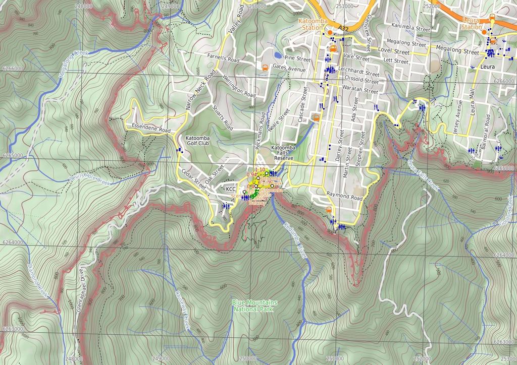
1 Katoomba Falls Circuit hr 5 mins.5 km Circuit Hard track 59m For those looking for a walk involving more than simple boardwalk, this trail winding through the temperate rain forest could be just the thing. Katoomba Falls cannot fail to dazzle as they cascade down the cliffs, and the opportunity to stop for a quick cup of coffee in Katoomba Falls Kiosk makes this walk all the more appealing. 952m Maps, text & images are copyright wildwalks.com Thanks to OSM, NASA and others for data used to generate some map layers. 835m Blue Mountains National Park
 or the Scenic Cableway, into the Jamison Valley, and explore the")
2 Scenic World Scenic World is one of the most renowned tourist attractions of Katoomba and the Blue Mountains. Located on the cliffs of the Jamison Valley, visitors can enjoy a ride on the Scenic Railway (the world's steepest incline railway) or the Scenic Cableway, into the Jamison Valley, and explore the Scenic Walkway from the base. Alternatively, the Scenic Skyway offers a bird's eye view over the valley, with a glass floor to enhance the experience. Scenic World also features a revolving restaurant, a cafe and a kiosk, in addition to the documentary theatre and souvenir shop. Rides can be purchased, starting from $6 for adults and $ for children, and combination or family passes are available. More info. Vaniman's Lookout Vaniman's Lookout is a fenced, long and narrow lookout on the cliff edge, opposite Reids Plateau. The view looks directly over the Three Sisters across the Kedumba Valley, under the Scenic Skyway. The lookout was considered one of the finest views on the Three Sisters in the 9's. The lookout was named after Chester Melvin Vaniman in 95, a well-know adventurer and artist from the USA, who visited the Blue Mountains in 93. More info. Juilets Balcony Juliets Balcony is a spectacular lookout, perched on top of a rock buttress near Orphan Rock, under the Scenic Skyway. The lookout provides sweeping views of the start of the Kedumba Valley, from Katoomba Falls to the Three Sisters. The lookout is accessed by a staircase, off the Furber Steps track. The fenceline continues along the lookout, forming a long, fenced balcony. Rainforest Lookout Unlike many lookouts in the area, Rainforest Lookout does not offer sweeping valley views. Instead, this lookout offers an opportunity to get up close and personal with the canopy of the rainforest. Spend some time in the cool shade listening to the birds and Witches Leap creek passing by. A sign at the lookout explains that there once were wood-fired barbeques here for picnics, but removed due to the toll on the local environment. Before You walk Bushwalking is fun and a wonderful way to enjoy our natural places. Sometimes things go bad, with a bit of planning you can increase your chance of having an ejoyable and safer walk. Before setting off on your walk check ) Weather Forecast (BOM Central Tablelands District) 2) Fire Dangers (Greater Sydney Region) 3) Park Alerts (Blue Mountains National Park) ) Research the walk to check your party has the skills, fitness and equipment required 5) Agree to stay as a group and not leave anyone to walk solo Think before you TREK The 'Think before you TREK' program developed by NSW Police & NPWS promotes the benefits of planning ahead for your bushwalking trip by using an easy to remember acronym: T R E K Take adequate supplies of food, water, navigation and first aid equipment. Register your planned route and tell friends and family when you expect to return. Emergency beacon (PLB's) should be carried on walks with significant gaps in mobile coverage (check terrain profile). Keep to your planned route and follow the map and walking trails. Topo Maps The maps provided on wildwalks are helpful, but there are times where you may need maps covering a broader area. Maps that cover this walk include; :5 Map Series:Six Foot Track :25 Map Series:893S KATOOMBA : Map Series:893 KATOOMBA Grade This walk has been graded using the AS The overall grade of the walk is dertermined by the highest classification along the whole track. Length Time Quality of track Grade /6 Hard track.5 km Circuit hr 5 mins Rough track, where fallen trees and other obstacles are likely (/6) Signs Directional signs along the way (3/6) Experience Required Weather Infrastructure Some bushwalking experience recommended (3/6) Weather generally has little impact on safety (/6) Limited facilities, not all cliffs are fenced (3/6)
3 Are you ready to have fun? Please ensure you and your group are well prepared and equipped for all possible hazards and delays. Check park closures, weather information and Fire Danger Rating before setting out. Optional side trips and alternate routes noted are not included in this walks overall grade, length or time estimate. Please allow extra time for resting and exploring areas of interest. The authors, staff and owners of wildwalks take care in preparing this information but will not accept responsibility for any inconvenience, loss or injury you may experience. Please take care, have fun - Happy Walking. Getting there You can get to Scenic World (gps: , 5.3) by car or bus. Car: There is free parking available. This is a circuit, so you will finish back at the start. Find up to date and more information inlcuding; travel directions, weather, park closures and walker feedback at Scenic World Scenic World is one of the most renowned tourist attractions of Katoomba and the Blue Mountains. Located on the cliffs of the Jamison Valley, visitors can enjoy a ride on the Scenic Railway (the world's steepest incline railway) or the Scenic Cableway, into the Jamison Valley, and explore the Scenic Walkway from the base. Alternatively, the Scenic Skyway offers a bird's eye view over the valley, with a glass floor to enhance the experience. Scenic World also features a revolving restaurant, a cafe and a kiosk, in addition to the documentary theatre and souvenir shop. Rides can be purchased, starting from $6 for adults and $ for children, and combination or family passes are available. More info. Scenic World (2 m 3 mins) From the Scenic World main entrance, this walk follows the 'Prince Henry Cliff Walk' signs down the concrete steps and around to the back of the building, where it comes to a wooden footbridge that curves around behind the main car park. At the end of the footbridge, this walk comes to an intersection with the Prince Henry Cliff Walk..2 End of wooden footbridge (5 m ) Continue straight: From the intersection, this walk follows the bush track down the gentle hill, winding down some wooden steps as the track bends around to the right. It then arrives at the signposted intersection of the 'Prince Henry Cliff Walk' and the track to the base of the Scenic Railway..7 Int of Prince Henry Cliff Walk and Katoomba Falls ( m ) Turn right: From the intersection, this walk heads down the steep wooden steps, following the signs to the bottom of the Scenic Railway. The walk comes to the intersection of Vanimans Lookout at the bottom of the steps..2 Vaniman's Lookout Vaniman's Lookout is a fenced, long and narrow lookout on the cliff edge, opposite Reids Plateau. The view looks directly over the Three Sisters across the Kedumba Valley, under the Scenic Skyway. The lookout was considered one of the finest views on the Three Sisters in the 9's. The lookout was named after Chester Melvin Vaniman in 95, a well-know adventurer and artist from the USA, who visited the Blue Mountains in 93. More info..2 Vanimans Lookout ( m 3 mins) Turn right: From Vanimans Lookout, this walk follows the bush track heading away from the bottom of the wooden steps. The track winds around the side of the hill and down the steep metal stairs. At the bottom, the walk comes to the intersection of the Katoomba Falls Round Walk and Juliets Balcony track (unsignposted)..32 Optional sidetrip to Juliets Balcony ( m ) Veer right: From the intersection, this walk heads up the short set of wooden steps, winding up to the raised rock platform, and along the bush track to the edge of the fenced-off rock shelf. At the end of this side trip, retrace your steps back to the main walk then Turn right..32 Juilets Balcony Juliets Balcony is a spectacular lookout, perched on top of a rock buttress near Orphan Rock, under the Scenic Skyway. The lookout provides sweeping views of the start of the Kedumba Valley, from Katoomba Falls to the Three Sisters. The lookout is accessed by a staircase, off the Furber Steps track. The fenceline continues along the lookout, forming a long, fenced balcony..32 Int of Katoomba Falls Round Walk and Juliets Balco (6 m ) Veer left: From the intersection, this walk follows the long set of wooden steps winding down the side of the hill. After this, the walk flattens out for a short distance then continues up a short set wooden steps to the intersection of the Round Walk and the Furber Steps track..38 Int of Katoomba Falls Round Walk and Furber Steps ( m ) Turn right: From the intersection, this walk follows the 'Base of Scenic Railway' signpost down the wooden steps to the bottom, where it comes to the Rainforest Lookout..39 Rainforest Lookout Unlike many lookouts in the area, Rainforest Lookout does not offer sweeping valley views. Instead, this lookout offers an opportunity to get up close and personal with the canopy of the rainforest. Spend some time in the cool shade listening to the birds and Witches Leap creek passing by. A sign at the lookout explains that there once were wood-fired barbeques here for picnics, but removed due to the toll on the local environment..39 Rainforest Lookout (2 m ) Turn right: From the Rainforest Lookout, the track follows the bush track heading past the base of the wooden steps and then through the forest for a short while, until it reaches the signposted intersection of the Underfalls Walk.. Int of Furber Steps and Katoomba Falls Lookout Tra (8 m 6 mins) Turn left : From the intersection, this walk follows the 'Underfalls Walk' sign down a short set of steps and across a small waterfall using the wooden bridge (This creek flows from Witches Leap all the way down to Veras Grotto). Once past the falls, the track continues through the rainforest, winding along the well-defined path until arriving at Katoomba Falls Lookout, right at the base of the falls..59 Katoomba Falls The Katoomba Falls are among the most famous waterfalls in the the Blue Mountains region. The Kedumba River falls about 5 meters in 2 main stages. The Undercliff Track, from the Furber Steps, can be used to access the first landing of the waterfall. The Katoomba Falls can be viewed from most lookouts in the the area, including from the bottom of the falls at Cooks Landing on Federal Pass, or from the track running next to the Kedumba River at the top of the falls. These falls are also a highlight for the trip across the Scenic Skyway..59 Katoomba Falls (35 m 9 mins) Turn around: From the Katoomba Falls Lookout, this walk follows the only bush track, winding through the temperate rainforest for about 5 to 2 metres, before crossing a small creek at a wooden bridge. From here the walk continues up the short set of steps until reaching the signposted intersection of the Furber Steps. Turn right: From the intersection, the track follows the bush track heading up the hill, winding up through the forest for a short while. Soon the track bends slightly around to the right and comes to the Rainforest Lookout, at the base of the set of wooden steps. Turn left : From the Rainforest Lookout, this walk heads up the wooden steps, climbing to the top where it comes to a 'T' intersection with the 'Round Walk' track. Turn right: From the intersection, this walk follows the 'Caravan Park' sign along the hardened path and up the wooden steps, continuing to wind up the side of the hill as the track climbs up a few more sets of wooden steps. This walk Witches Leap Creek at the small wooden bridge, winding up the wooden steps that zigzag up through the gully, to the intersection of the Witches Leap Lookout..9 Witches Leap (3 m mins) Veer right: From the Witches Leap Lookout, this walk heads up the wooden steps and up the hardened path that winds up through the gulley, climbing past a small rest area at a large rock overhang. The walk heads to the top of the hill, coming to the intersection of the Prince Henry Cliff Walk and the Reids Plateau loop walk..7 Int of Katoomba Kiosk Loop and Witches Leap Track (3 m ) Turn left: With the Katoomba Falls track to the left and the picnic bench to the right, this walk heads north up the concrete stairs, passing a 'Greenspace Project' sign. The walk comes to the top of the stairs, to the signposted intersection of 'Round Walk' at the back of the small park near the Katoomba Kiosk.. Optional sidetrip to Katoomba Falls Kiosk (5 m ) Continue straight: From the intersection, this walk crosses through the park, passing the large information signs and the water fountain, arriving at the Katoomba Kiosk. At the end of this side trip, retrace your steps back to the main walk then Turn right.. Katoomba Falls Kiosk The Katoomba Falls Kiosk serves a variety of light and healthy meals including breakfast, lunch and Devonshire teas. A drink enjoyed here will add to the experience of any local bushwalk. For more information, phone (2) More info.. Int of Katoomba Kiosk Track and Prince Henry Cliff (3 m 9 mins) Veer left: From the intersection, the walk follows the 'Scenic Railway' sign along the hardened bush track, winding along the side of the hill as the track heads through the forest, to the signposted intersection of the Round Walk and the Prince Henry Cliff Walk. Veer right: From the intersection, this walk follows the only unsignposted bush track up the gentle hill. It winds up the wooden steps, bending around to the left until it flattens out at the intersection with the Scenic World footbridge. Continue straight: From the intersection, this walk heads along the wooden footbridge that winds around the back of the Scenic World multi-story car park, to the concrete footpath. The walk continues around the main building, climbing up some concrete steps to the main entrance of Scenic World.
4
5 Powered by TCPDF ( Summary navigation sheet for the Katoomba Falls Circuit km From Up/Dwn Length Initial directions (Use full tracknotes and maps for more detail) Start Scenic World ,5.3 (GR Katoomba, 9967).2 End of wooden footbridge ,5.36 (GR Katoomba, 568).7 Int of Prince Henry Cliff Walk and Katoomba Falls Round Walk ,5.32 (GR Katoomba, 568).2 Vanimans Lookout ,5.322 (GR Katoomba, 568).32 Int of Katoomba Falls Round Walk and Juliets Balcony Track ,5.323 (GR Katoomba, 567).32 Int of Katoomba Falls Round Walk and Juliets Balcony Track ,5.323 (GR Katoomba, 567).38 Int of Katoomba Falls Round Walk and Furber Steps ,5.32 (GR Katoomba, 567).39 Rainforest Lookout ,5.325 (GR Katoomba, 567). Int of Furber Steps and Katoomba Falls Lookout Track ,5.325 (GR Katoomba, 567).59 Katoomba Falls ,5.32 (GR Katoomba, 5268).9 Witches Leap ,5.32 (GR Katoomba, 568).7 Int of Katoomba Kiosk Loop and Witches Leap Track ,5.33 (GR Katoomba, 569). Int of Katoomba Kiosk Track and Prince Henry Cliff Walk ,5.335 (GR Katoomba, 5269). Int of Katoomba Kiosk Track and Prince Henry Cliff Walk ,5.335 (GR Katoomba, 5269) m 3 mins 5 m m m 3 mins From the Scenic World main entrance, this walk follows the 'Prince Henry Cliff Walk' signs down the concrete steps and around to the back of the building, where it comes to a wooden footbridge that curves around beh... Continue straight: From the intersection, this walk follows the bush track down the gentle hill, winding down some wooden steps as the track bends around to the right. Turn right: From the intersection, this walk heads down the steep wooden steps, following the signs to the bottom of the Scenic Railway. Turn right: From Vanimans Lookout, this walk follows the bush track heading away from the bottom of the wooden steps. m Optional sidetrip to Juliets Balcony. Veer right: From the intersection, this walk heads up the short set of wooden steps, winding up to the raised rock platform, and along the bush track to the edge of the fenced-off rock shelf. 6 m Veer left: From the intersection, this walk follows the long set of wooden steps winding down the side of the hill. m Turn right: From the intersection, this walk follows the 'Base of Scenic Railway' signpost down the wooden steps to the bottom, where it comes to the Rainforest Lookout. 2 m Turn right: From the Rainforest Lookout, the track follows the bush track heading past the base of the wooden steps and then through the forest for a short while, until it reaches the signposted intersection of the... 8 m 6 mins 35 m 9 mins 3 m mins 3 m 5 m 3 m 9 mins Turn left : From the intersection, this walk follows the 'Underfalls Walk' sign down a short set of steps and across a small waterfall using the wooden bridge (This creek flows from Witches Leap all the way down to... Turn around: From the Katoomba Falls Lookout, this walk follows the only bush track, winding through the temperate rainforest for about 5 to 2 metres, before crossing a small creek at a wooden bridge. Veer right: From the Witches Leap Lookout, this walk heads up the wooden steps and up the hardened path that winds up through the gulley, climbing past a small rest area at a large rock overhang. Turn left: With the Katoomba Falls track to the left and the picnic bench to the right, this walk heads north up the concrete stairs, passing a 'Greenspace Project' sign. Optional sidetrip to Katoomba Falls Kiosk. Continue straight: From the intersection, this walk crosses through the park, passing the large information signs and the water fountain, arriving at the Katoomba Kiosk. Veer left: From the intersection, the walk follows the 'Scenic Railway' sign along the hardened bush track, winding along the side of the hill as the track heads through the forest, to the signposted intersection of...
Scenic World to Echo Point
 Scenic World to Echo Point 1 hr 15 mins 2.1 km One way Moderate track 192m This is one of the most popular tourist walks in the Katoomba area. The walk follows the cliffs along a well maintained and signposted
Carrington Park to Leura Forest and pass loop
 Carrington Park to Leura Forest and pass loop 3 hrs Hard track 4.8 km Circuit 4 674m This walk is a fantastic way to see Leura Forest. The walk descends from Carrington Park, visiting Leura Forest and
Scenic world to Three Sisters Loop via Furber Steps
 Scenic world to Three Sisters Loop via Furber Steps 5 hrs 5.8 km Circuit Hard track 722m This walk starts from the popular Scenic World, in Katoomba, and winds down the Furber steps into the Jamison Valley,
Echo Point to Leura Forest via Three Sisters and Giant Stairs loop
 Echo Point to Leura Forest via Three Sisters and Giant Stairs loop 3 hrs 3.8 km Circuit Hard track 512m This walk starts from the popular Echo Point, in Katoomba, and winds down to the base of the Three
Wentworth Falls Conservation Hut Loop
 Wentworth Falls Conservation Hut Loop 3 hrs Hard track 6.7 km Circuit 4 341m This scenic walk from Wentworth Falls Station, winds along the Nature Trail to Conservation Hut, then drops into the magnificent
Govetts Leap Loop. 1065m. 909m Blue Mountains National Park. 4 hrs 30 mins 8.7 km Circuit. Hard track 380m
 Govetts Leap Loop 4 hrs 30 mins 8.7 km Circuit Hard track 380m This walk, from Blackheath Train Station, is a fantastic way to see some of the iconic areas of the Blue Mountains in the Blackheath area.
Popes Glen, Pulpit Rock, Govetts Leap and Braeside Walk
 Popes Glen, Pulpit Rock, Govetts Leap and Braeside Walk 8 hrs Hard track 13.6 km Circuit 4 1068m This large circuit walk, from Popes Glen to Pulpit Rock, Govetts leap and along the Braeside Track, passes
Waterfall to Heathcote
 Waterfall to Heathcote 5 hrs Hard track 10.8 km One way 4 467m This walk explores the heart of Heathcote National Park, and is easily accessed with a train station at either end. Although relatively close
Heathcote to Engadine via Audley
 Heathcote to Engadine via Audley 6 hrs 3 mins 5 km One way Hard track 4 635m Covering a large section of central Royal National Park, this walk goes through the heath and scrub along a well managed and
Morgans Creek to Padstow
 Morgans Creek to Padstow 2 hrs 45 mins 8 km One way Moderate track 3 144m This pleasant walk starts from the Morgans Creek park, at Henry Lawsons Drive, and follows the Georges River past the Boomerang
Little Digger Track. 68m. 1 Hr 2.2 km One way. Moderate track 93m. Moores Creek Reserve
 Little Digger Track Hr 2.2 km One way Moderate track 93m This walk follows Moores Creek through several reserves in east Roseville and East Lindfield. The track is named after Australia's 7th Prime Minster,
Wentworth Falls Station Loop (Undercliff Walk)
") Wentworth Falls Station Loop (Undercliff Walk) 4 hrs 3 mins Hard track 8.9 km Circuit 658m 4 This walk passes some stunning waterfalls and views into the Jamison Valley, following the cliff edges around
Wentworth Falls Station Loop (Undercliff Walk) 4 hrs 3 mins Hard track 8.9 km Circuit 658m 4 This walk passes some stunning waterfalls and views into the Jamison Valley, following the cliff edges around
Federal Pass Walking Track
 Federal Pass Walking Track 5 hrs Hard track 8 km One way 4 989m This classic trail follows along the base of the cliffs from Leura to the Golden Stairs, passing many of the more popular sights of the Katoomba
National Pass from Wentworth Falls to Conservation Hut
 National Pass from Wentworth Falls to Conservation Hut 3 hrs Hard track 3.6 km One way 739m Starting at Wentworth Falls picnic area, this scenic and historic walk explores many waterfalls, lookouts and
Currie Rd to Davidson Park
 Currie Rd to Davidson Park 3 hrs 7.2 km One way Moderate track 28m Starting at Currie Rd in Forestville, this walk follows Middle Harbour to Davidson Park, under Roseville Bridge. There are two optional
Under and Over Cliff Walk
 Under and Over Cliff Walk 4 hrs 9.4 km Circuit Moderate track 576m This walk from Wentworth Falls Station is a fantastic way to see a large majority of the Wentworth Falls cliffline. The track winds under
Dead Horse Gap Loop track
 Dead Horse Gap Loop track 4 hrs 30 mins Hard track 9.8 km Circuit 144m 4 This walk starts with a ride up the Kosciuszko Express Chairlift. There is an opportunity to eat at Australia's highest restaurant,
The Foreshore Walk. 24m. 1m Lake Macquarie LGA. 1 hr 15 mins 2.9 km One way. Hard track 81m
 The Foreshore Walk 1 hr 15 mins 2.9 km One way Hard track 81m This walk traverses the coastline of the Green Point reserve. By following a variety of tracks and occasionally traveling inland through eucalyptus
Rail to River Walk. 3 hrs. Hard track 7.5 km Circuit. 222m
 Rail to River Walk 3 hrs Hard track 7.5 km Circuit 4 222m This walk is a great one from Chatswood Station to the Lane Cove River National Park. The walk descends through the vegetated bushland which fills
Wattamolla to Big Marley Beach
 Wattamolla to Big Marley Beach 4 hrs 10.4 km Circuit Moderate track 4m This walk is an excellent loop which takes in both the coast and the heathy inland of Royal National Park. Nearly the whole walk has
Epping to Pennant Hills Station (via Lane Cove River)
") Epping to Pennant Hills Station (via Lane Cove River) 3 hrs 5 mins 8.4 km One way Hard track 249m This walk, from Epping to Pennant Hills Station, is a great way to see the upper Lane Cove River Valley.
Epping to Pennant Hills Station (via Lane Cove River) 3 hrs 5 mins 8.4 km One way Hard track 249m This walk, from Epping to Pennant Hills Station, is a great way to see the upper Lane Cove River Valley.
Epping to Eastwood Station (via Lane Cove River)
") Epping to Eastwood Station (via Lane Cove River) hrs 45 mins 10.2 km One way Moderate track 189m Epping to Eastwood, via Lane Cove River, is the longer route through the bush between the stations. This
Epping to Eastwood Station (via Lane Cove River) hrs 45 mins 10.2 km One way Moderate track 189m Epping to Eastwood, via Lane Cove River, is the longer route through the bush between the stations. This
Sid Pulsford Walk. 175m. 33m. 1 hr 45 mins 4.1 km One way. Hard track 118m. Gosford LGA
 Sid Pulsford Walk 1 hr 5 mins.1 km One way Hard track 118m Sid Pulsford Walk explores the ridge top of Kincumber Mountain, from Honeman's Rock to Green Point. The walk mostly follows wide management trails.
Hunters Hill to Epping Road
 Hunters Hill to Epping Road 2 hrs 30 mins 5.5 km One way Moderate track 154m An enjoyable walk through lower sections of the Lane Cove National Park, this walk features plenty of mangroves next to the
Little Digger Track to Davidson Reserve and Lyrebird Circuit
 Little Digger Track to Davidson Reserve and Lyrebird Circuit 4 hrs 3 mins 11.5 km One way Hard track 4 47m Exploring both the eastern and western sides of Middle Harbour Creek, this walk follows the Little
Hornsby Blue Gum Walk
 Hornsby Blue Gum Walk 3 hrs Hard track 6.7 km Circuit 4 374m This delightful loop is one of the prettiest and most popular walks in the Hornsby area. Going from an environment of ferns and clear bushland
Echo Point to Leura Forest Circuit
 Echo Point to Leura Forest Circuit 3 hrs 4.8 km Circuit Hard track 588m Forming a circuit around the cliffs and then the valley floor, this is a walk more then capable of convincing a walker of the beauty
Callicoma Loop. 174m. 98m. 2 hrs. Hard track 5.1 km Circuit. 153m
 Callicoma Loop 2 hrs Hard track 5.1 km Circuit 153m This great circuit walk passes through some really nice forest around the fringe of Cherrybrook. Highlights of the walk include some beautiful rock overhangs
Mackerel Beach, West Head Loop
 Mackerel Beach, West Head Loop 5 hrs 8.6 km Circuit Hard track 422m The Mackerel Beach, West Head Loop is a walk which explores a large part of the West Head. The journey starts and finishes with a ferry
Wallarah Coastal Walk
 Wallarah Coastal Walk 3 hrs 8.3 km Return Hard track 247m This walk starts at Caves Beach and travels south along the coastline, until reaching the Pinney s Headland Lookout. There are many opportunities
Blackheath Station to Junction Rock Loop (via Grand Canyon and Popes
 Blackheath Station to Junction Rock Loop (via Grand Canyon and Popes 8 hrs 30 mins 18.2 km Circuit Hard track 4 1254m This circuit starts in Blackheath and heads down into the Grand Canyon and Rodriguez
Teralba to Charlestown Park track head
 Teralba to Charlestown Park track head 4 hrs 30 mins 13.3 km One way Moderate track 3 220m This section of the Great North Walk starts from the Teralba train station and winds down and around the edge
Wentworth Falls Loop. 893m. 665m. 6 hrs 10.2 km Circuit. Hard track 1093m. Blue Mountains National Park
 Wentworth Falls Loop 6 hrs 1.2 km Circuit Hard track 193m This is a great walk, both in size and spectacular views. The walk makes its way from Wentworth Falls train station and drops off the plateau,
Campbell Drive to Snapper Point
 Campbell Drive to Snapper Point 1 hr 45 mins 4.2 km One way Experienced only 135m This walk follows the Coast Track to Frazer Beach, along the Geebung and (overgrown) Grass Tree Tracks. From the northern
Balmoral Beach to The Spit
 Balmoral Beach to The Spit 2 hrs 30 mins.3 km One way Hard track 85m This walks follows the coast from Balmoral to the Spit and across Spit Bridge. There are some alternate tracks to consider at high-tides,
Wentworth Falls Station Loop
 Wentworth Falls Station Loop 5 hrs 3 mins 9.5 km Circuit Hard track 4 13m The Wentworth Falls Station Loop takes in most of the upper tracks around Wentworth Falls. There are many scenic views near the
Green Point Circuit Walk
 Green Point Circuit Walk 3 hrs 7.7 km Circuit Hard track 269m This walk visits all of the popular locations in Green Point Reserve, as well as some of the lesser-visited areas inland. Taking in Sea Eagle
Rail to River and Stringybark Creek Reserve Walk
 Rail to River and Stringybark Creek Reserve Walk 4 hrs Hard track 11.2 km Circuit 4 302m This walk begins in the busy city of Chatswood and soon enters the nearby bushland around the Lane Cove River. The
Mackerel Beach and Resolute Loop
 Mackerel Beach and Resolute Loop 3 hrs 5.4 km Circuit Hard track 384m This walk is another great walk in Ku-ring-gai Chase National Park, accessed by ferry. From the Mackerel Beach wharf, this walk uses
The Basin Track and Mackerel Track
 The Basin Track and Mackerel Track 3 hrs 5.9 km Circuit Hard track 226m This walk is a great way to see some popular areas in Ku-ring-gai Chase National Park. The walk from West Head Rd travels to The
Upper Rumbalara circuit
 Upper Rumbalara circuit 1 hr 30 mins 3.3 km Circuit Hard track 176m A great circuit walk, covering most of the walking tracks and sights in the upper section of the Rumbalara Reserve. There is some really
Sphinx, Warrimoo and Bobbin Head tracks
 Sphinx, Warrimoo and Bobbin Head tracks 4 hrs 9.6 km Circuit Moderate track 499m This great walk starts at the Sphinx Memorial and loops around via Cowan Creek, exploring diverse environments as it changes
Middle Harbour Creek Loop
 Middle Harbour Creek Loop 5 hrs 45 mins 15.1 km Circuit Experienced only 5 570m This walk explores the upper reaches of Middle Harbour Creek, starting and ending at the great parklands at Davidson Park,
Bouddi Coastal Walk. 5 hrs. Hard track 8.1 km One way. 364m
 Bouddi Coastal Walk 5 hrs Hard track 8.1 km One way 4 364m This is one of the longer walks in the Bouddi National Park and it is rich in scenery. The walk follows the coastline with many side trips to
Spit Bridge to Middle Head Forts
 Spit Bridge to Middle Head Forts 2 hrs 30 mins 6.3 km One way Hard track 4 181m This scenic walk takes you from the Spit Bridge, along the coast to explore the Middle Head Forts. There are a few alternate
De Burghs Bridge to Fullers Bridge
 De Burghs Bridge to Fullers Bridge 2 hrs 3 mins Hard track 6 km One way 2m 4 Following the Lane Cove River, this walk mostly follows a section of the Great North Walk and is well maintained and signposted.
Berowra to Mt Kuring-gai
 Berowra to Mt Kuring-gai 4 hrs 30 mins 9.4 km One way Hard track 4 551m From the ridges above Cowan Creek, this walk takes in some great lookouts (especially around Mt Kuringgai) as well as enjoying an
Taronga Wharf to Chowder Bay
 Taronga Wharf to Chowder Bay 2 hrs 4.4 km One way Moderate track 246m Starting at Taronga Wharf, this walk passes many icons of Sydney, including Taronga Zoo, HMAS Sydney Mast, Chowder Bay. The walk also
De Burgs Bridge to Thornleigh station
 De Burgs Bridge to Thornleigh station 3 hrs 45 mins 9.7 km One way Hard track 4 363m This walk follows a section of the Great North Walk, starting from De Burghs bridge. The walk winds north west, through
Woolwich Wharf to Boronia Park
 Woolwich Wharf to Boronia Park 2 hrs 5.8 km One way Moderate track 175m Going through the streets of Hunters Hill, this walk is on the first segment of the Great North Walk. The majority of the walk is
Dubbo Gully and Ten Mile Hollow Circuit (via Clares Bridge)
") Dubbo Gully and Ten Mile Hollow Circuit (via Clares Bridge) 2 Days Hard track 24.3 km Circuit 4 1117m This two day (or ten hour) walk follows several historic roads, now closed to traffic. Starting with
Dubbo Gully and Ten Mile Hollow Circuit (via Clares Bridge) 2 Days Hard track 24.3 km Circuit 4 1117m This two day (or ten hour) walk follows several historic roads, now closed to traffic. Starting with
Patonga to Woy Woy. 5 hrs 45 mins 15.5 km One way. Hard track. 497m
 Patonga to Woy Woy 5 hrs 45 mins 15.5 km One way Hard track 4 497m This walk explores a variety of environments from the shore line and coastal cliffs near Patonga, to the dry, rocky and open ridge line.
Roseville to Macquarie Park
 Roseville to Macquarie Park 3 hrs 3 mins 8.8 km One way Hard track 4 29m This walk starts at Roseville station and explores the streets and alleyways of Roseville before joining the main spine of the Great
Glenbrook and Euroka Circuit
 Glenbrook and Euroka Circuit 2 Days 16.6 km Circuit Experienced only 790m This two day circuit, returning to Glenbrook Station, is a scenic walk which passes many of the tourist attractions within the
Epping to Gordon Station
 Epping to Gordon Station 4 hrs 15 mins 11.7 km One way Hard track 4 365m This walk, from Epping Station to Gordon Station, passes below the homes which sit on the hills high above the Lane Cove River.
Thornleigh to Hornsby
 Thornleigh to Hornsby 4 hrs Hard track 10.2 km One way 4 526m Starting at Thornleigh station you walk through suburban streets for a short while before diving into the bush at the southern end of Berowra
Gordon to Chatswood Station
 Gordon to Chatswood Station 4 hrs 30 mins 12.2 km One way Hard track 4 381m This walk is a great way to get into the bush without being far from civilisation. The walk wanders through untouched valleys
Spit Bridge to Manly (Manly Scenic Walkway)
") Spit Bridge to Manly (Manly Scenic Walkway) 3 hrs 45 mins 9.1 km One way Moderate track 349m The Spit to Manly walk is a classic bushwalk on Sydney's Northern Beaches. The walk follows a well-maintained
Spit Bridge to Manly (Manly Scenic Walkway) 3 hrs 45 mins 9.1 km One way Moderate track 349m The Spit to Manly walk is a classic bushwalk on Sydney's Northern Beaches. The walk follows a well-maintained
Hermitage Foreshore Track
 Hermitage Foreshore Track 1 Hr 2.2 km One way Moderate track 123m The Hermitage Foreshore Walk is a wonderful way to explore Sydney Harbour from the perspective of South Head. This walk starts from Nielsen
Lane Cove Tourist Park River Circuit
 Lane Cove Tourist Park River Circuit 5 hrs 12 km Circuit Hard track 383m This walk follows a large section of Lane Cove River. The walk follows the Riverside Walking track up the Lane Cove River to De
Rumbalara Explorer. 158m. 5m Rumbalara Reserve. 2 hrs 45 mins 6.1 km Circuit. Hard track 326m
 Rumbalara Explorer 2 hrs 5 mins 6.1 km Circuit Hard track 326m Pretty well the grand tour of the Rumbalara Reserve, this walk takes in much of the great scenery the reserve has to offer. The walk covers
Faulconbridge to Blaxland
 Faulconbridge to Blaxland 2 Days Experienced only 15.2 km One way 5 693m This two-day walk, or very solid one-day walk, takes you from station to station, through lush, scenic forest in the lower Blue
Charlestown Park trackhead to Newcastle station
 Charlestown Park trackhead to Newcastle station 5 hrs 30 mins 12.1 km One way Hard track 4 287m This section of the Great North Walk starts from the Charleston Park track head and winds through the streets
The Coast Track. 2 Days. Hard track 27.4 km One way. 1351m
 The Coast Track 2 Days Hard track 27.4 km One way 4 1351m Heading south, this walk covers the coastline of the Royal National Park and can truly only be described as amazing. With breathtaking coastal
Sphinx to Mt Kuring-gai
 Sphinx to Mt Kuring-gai 4 hrs 45 mins 1.7 km One way Hard track 673m This walk starts at the Sphinx War Memorial and follows some well maintained and popular walking tracks down to Cowan Creek. Enjoy the
North Ryde Fairyland circuit
 North Ryde Fairyland circuit 2 hrs 30 mins Hard track 6.9 km Circuit 193m 4 Starting at North Ryde train station this walk explores a stretch of the Lane Cove River, visiting the historic Fairlylands Pleasure
Gosford to Lisarow. 202m
 Gosford to Lisarow 4 hrs 3 mins Hard track 11.3 km One way 4 479m This walk is a great way to explore the ridge-top bushland between Gosford and Lisarow. Passing through Rumbalara and Katandra Reserves,
Bobbin Head Loop. 166m. 0m Ku-ring-gai Chase National Park. 5 hrs 12.9 km Circuit. Hard track 619m
 Bobbin Head Loop 5 hrs 12.9 km Circuit Hard track 619m This great circuit walk enjoys a variety of landscapes in Ku-ring-gai Chase National Park. The walk starts at the historic Sphinx war memorial and
Manly to Seaforth Oval
 Manly to Seaforth Oval 5 hrs 45 mins 13.7 km One way Moderate track 3 624m This walk follows the Manly to Spit Scenic Walkway, then continues past The Spit Bridge to Seaforth Oval. The walk provides magnificent
Cape Banks Circuit. 50m. 2m Botany Bay National Park. 3 hrs 7.3 km Circuit. Hard track 190m
 Cape Banks Circuit 3 hrs 7.3 km Circuit Hard track 19m This Cape Banks Circuit has a lot to offer and is thoroughly recommended. The walking travels over beaches, through coastal forest and across exposed
Narrabeen Lagoon Trail (from Middle Creek)
") Narrabeen Lagoon Trail (from Middle Creek) 2 hrs 30 mins 8.6 km Circuit Very easy 1 105m The Narrabeen Lagoon Trail is a wonderful and accessible walk on the Northern Beaches of Sydney. The trail is used
Narrabeen Lagoon Trail (from Middle Creek) 2 hrs 30 mins 8.6 km Circuit Very easy 1 105m The Narrabeen Lagoon Trail is a wonderful and accessible walk on the Northern Beaches of Sydney. The trail is used
ULTRA-TRAIL AUSTRALIA May 2018 COURSE DESCRIPTION AND COURSE NOTES
 ULTRA-TRAIL AUSTRALIA 100 19-20 May 2018 COURSE DESCRIPTION AND COURSE NOTES LEG 1 Scenic World (Start) to Narrow Neck (Checkpoint 1) Course Description: From the start, at the front entrance of Scenic
Chatswood to Epping Station
 Chatswood to Epping Station 6 hrs Hard track 16.3 km One way 4 533m This walk, from Chatswood to Epping, is a long but enjoyable walk along the Lane Cove valley. The walk mostly follows the Lane Cove River
Bouddi Ridge and Coastal Walk
 Bouddi Ridge and Coastal Walk 2 Days Hard track 27 km Circuit 4 126m This overnight walk takes in the majority of the magnificent Bouddi National Park. The walk starts from the pleasant Putty Beach camping
Taronga Zoo to Spit Bridge
 Taronga Zoo to Spit Bridge 5 hrs Hard track 1.4 km One way 4 41m This is a scenic and culturally rich walk with views over Sydney Harbour and many interesting heritage buildings along the way. The start
Light to Light Walk 2 days
 Light to Light Walk 2 days 2 Days Hard track 3.9 km One way 4 794m Over two days, this classic walk explores the coast from Boyd Tower to the Green Cape Lighthouse in the south. Hegartys Bay Camp is over
PRE-APPROVED WALKS. RED HANDS CAVE CIRCUIT Grade: Easy Description: A circuit walk from either the causeway or the Red Hands Cave parking area. 8km.
 Bushwalking Club Inc. PO Box 126 NSW 2777 www.springwoodbushwalker.org.au PRE-APPROVED WALKS The purpose of this list of pre-approved walks is to enable leaders to put on walks at very short notice (up
Six Foot Track. 1212m
 Six Foot Track 3 Days 44.8 km One way Hard track 4 2066m This classic walk takes you from Katoomba to Jenolan Caves via a historic horse route. The walk travels mainly along well-maintained service tracks
Sydney to Thornleigh via Lane Cove Tourist Park
 Sydney to Thornleigh via Lane Cove Tourist Park 2 Days 33 km One way Hard track 4 1114m This overnight walk starts from the Obelisk in Macquarie Park, Sydney, at the official start of the Great North Walk.
Harbour Bridge to Taronga Zoo
 Harbour Bridge to Taronga Zoo 4 hrs 9.8 km One way Moderate track 389m On this walk, you will explore much of the foreshore linking Milsons Point Station to Taronga Zoo Ferry wharf. The walk is mostly
SELF GUIDED TOURING ROUTE
 SELF GUIDED TOURING ROUTE Things to see and places to go on the loop from Orbost to Marlo, Cape Conran, Cabbage Tree and back to Orbost (or onwards to Cann River) V6 April 2017 This guide should be read
Beautiful Walks from the Blue Ball Inn
 Walk No. 7 COAST AND VALLEY WALK Countisbury, Glenthorne, County Gate, Brendon, Rockford and Wilsham 10 MILES APPROX. Walking time 5 hours approx. (not including breaks)> OS Sheet 64/74 Lynton and Lynmouth.
LET S get moving! campus walking routes. ulethbridge.ca/hr/wellness. University of Lethbridge 4401 University Dr. West Lethbridge, AB T1K 3M4
 LET S get moving! campus walking routes University of Lethbridge 4401 University Dr. West Lethbridge, AB T1K 3M4 ulethbridge.ca/hr/wellness Living Well at the U of L This walking guide is a result of feedback
THE BECK STONE Backstone Beck on Ilkley Moor
 THE BECK STONE Backstone Beck on Ilkley Moor 1 Three different routes which take in the best of the lower slopes of Ilkley Moor, with bracken, heather, a tarn (a small mountain lake) and rushing streams.
East Gippsland Walks 2013
 Orbost Community Walks Thursday 31st October Start times 9.30am and 9.45am Walks include: Sensory Gardens Walk. 9.30am. 2kms. There are some steep inclines & declines and road crossings. Forest Park Walk.9.45am.
MAPS & WALK NOTES. DAY 2: Greenwich Wharf to Woolwich Wharf
 MAPS & WALK NOTES DAY 2: Greenwich Wharf to Woolwich Wharf Total Distance: 15.5km Time: Approximately 5 hours 30 mins five Sections Walk Notes in Section Name Length Time 2:1 Greenwich Wharf to Northwood
10 Miles Circular 5 hours
 VISIT RYEDALE PICKERING AND CAWTHORN CAMPS 10 Miles Circular 5 hours Moderate Terrain 120616 A 10 mile (16km) there and back walk from the market town of Pickering in Ryedale. The route heads north through
VELINDRE VALLEYS WALK FOR STEFFAN
 VELINDRE VALLEYS WALK FOR STEFFAN IMPORTANT INFORMATION FOR WALKERS AND MARSHALS 1 Table of Contents Key Contact Numbers:... 3 Timetable and locations... 4 T-shirts... 4 Important Advice for Walkers...
Directions for Day 1: Colwood To Metchosin
 Colwood-Metchosin Page 1 of 8 Directions for Day 1: Colwood To Metchosin Start: Royal Roads University, Birds of a Feather B&B, or at Esquimalt Lagoon Finish: Your accommodation in Metchosin Time: 4-5
VERN S CAMP from Minginui
 VERN S CAMP from Minginui Map: Kuratau, 1:50,000 V18 Refer Figures 1, 3, 4 and 5 GPS: Geodetic Datum 1949 Refer Figure 10a (Geographic) and 10b (NZ Grid) How to get to START: From the police station on
Approximate distance: 5.5 miles For this walk we ve included OS grid references should you wish to use them. Start. End
 Approximate distance: 5.5 miles For this walk we ve included OS grid references should you wish to use them. End 4 1 Start 3 2 N W E S Reproduced by permission of Ordnance Survey on behalf of HMSO. Crown
Cleeve Common Self-Guided Walk 1 Family Circular
 Cleeve Common Self-Guided Walk 1 Family Circular Start point: Quarry Car Park Nearest postcode: GL52 3PW please note this is for the golf club. To find the quarry car park drive past the golf club car
Route: Skewsby Foulrice Stearsby
 Route: Skewsby Foulrice Stearsby Distance: 7 miles Map: Explorer: 300 Howardian Hills & Malton Start (OS ref): SE625710 Park in the village of Skewsby. Walk east out of the village to the T-Junction and
Tideswell to Castleton
 Tideswell to Castleton 1 Walk summary Length: 14 km, 8.5 miles Maps: OS Explorer OL1 The Peak District - Dark Peak Area, OS Explorer OL24 The Peak District - White Peak Area, OS Landranger 110 Sheffield
Start / Finish. Version 2
 Start / Finish Version 2 Gosford (Start) to Woy Woy Head South down Etna Street, crossing Henry Parry Drive, then Mann St, Gosford, where Etna St becomes Racecourse Road. Follow this road all the way
Christchurch to Hengistbury Head
 Last checked 6 June 2018 Document last updated: 13 July 2018 This document and information herein are copyrighted to Saturday Walkers Club. If you are interested in printing or displaying any of this material,
Hexham Abbey to the Racecourse Road
 Hexham Abbey to the Racecourse Road The Yarridge Road, or Racecourse Road as it is often known, runs along the ridge line to the south of Hexham and provides wonderful views of the river valley and fells
1. Kala Nera Milies Kala Nera
 1. Kala Nera Milies Kala Nera A beautiful and varied walk from Kala Nera, a tourist seaside village, to Milies which lies 400 metres higher up. From there it proceeds back down to Kala Nera along another
Loch Ness Shores Club Site
 Loch Ness Shores Club Site Camping and Caravanning Falls of Foyers Route Summary A strenuous walk from Loch Ness Shores Club Site. The route climbs through forest to The Upper Foyers Waterfall and then
CHRIS BROWN DISCOVERS SYDNEY S SECRET CANYONS
 CHRIS BROWN DISCOVERS SYDNEY S SECRET CANYONS Just a couple of hours from Sydney city centre, the Blue Mountains are home to spectacular slot canyons that have been eroded over millions of years into the