HYATTSVILLE TRANSPORTATION PLAN. City Council Update March 19, 2018
|
|
|
- Cora Cross
- 5 years ago
- Views:
Transcription


1 HYATTSVILLE TRANSPORTATION PLAN City Council Update March 19, 2018


2 AGENDA PROJECT GOALS DATA COLLECTION WHAT WE LEARNED NEXT STEPS


3 PROJECT GOALS Identify bicycle and pedestrian needs of the city Evaluate existing and future roadway needs Evaluate traffic calming and one-way streets Evaluate parking issues in target areas Prepare a wayfinding plan Evaluate school traffic and infrastructure Develop implementation-oriented Sequential Action Plan


4 Existing Conditions Public input Stakeholder conversations Field inventory Data analysis

5 PROJECT WEBSITE Linked to all other City of Hyattsville projects Bilingual website

6 WIKIMAP ENGLISH: ESPAÑOL: WikiMap in English and Spanish Online interactive map with comments about: Destinations Problem areas Connectivity gaps High traffic corridors Barriers to walking and biking
7 WIKIMAP RESPONSES 147 responses received as of March 13 (an increase since December) Most responses from Wards 1, 2, and 3 Need more responses from Wards 4 and 5 to understand travel habits there Ward 4 4% Ward 5 7% Ward 3 14% Outside HVL 5% Ward 2 33% Ward 1 37%


8 STAKEHOLDER INPUT September 20 City Hall
9 WHAT WE HEARD Destinations Routes people walk + bike Destinations include both Metro stations, Prince George s Plaza/UTC, and Arts District Most respondents identified major walking and biking routes in Wards 1 and 2

10 KEY ISSUES Parking issues High traffic University Town Center, Arts District identified as areas with parking issues Residents identified several high traffic City streets Queensbury 42 nd Hamilton/Jefferson Nicholson
11 DESIRED CONNECTIONS Connectivity needed Transit connectivity needed Missing connections cluster around Queens Chapel Road, Rhode Island/Baltimore Ave, Queensbury Road Need for transit connectivity around both Metro stations, Arts District

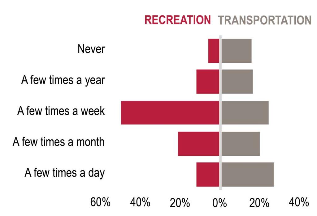
12 BICYCLING + WALKING HABITS
13 BARRIERS FOR WALKING + BIKING Respondents identified major roads as barriers for walking and biking East-West Highway Queens Chapel Adelphi Belcrest Hamilton + 38 th Rhode Island


14 FIELD INVENTORY Physical inventory assessing: Roadway network Sidewalk gaps Bicycle infrastructure Traffic calming Wayfinding signage Intersection operations Parking occupancy
15 TRAVEL PATTERNS Most trips beginning in Hyattsville end somewhere else, and most trips ending in Hyattsville begin somewhere else Largest share of trips to or from Hyattsville start or end elsewhere in Maryland Many short trips take place within Hyattsville- focusing on Prince Georges Plaza, Arts District, West Hyattsville Metro The busiest city streets are: Belcrest Hamilton Jefferson Nicholson Queensbury


16 INTERSECTIONS Assessed nearly 40 intersections Most intersections function relatively well Significant delay at: Queens Chapel/Nicholson Baltimore Ave/East West Highway Baltimore Ave/Hamilton Rhode Island Ave/Armentrout East West HWY/Toledo Terrace East West HWY/Editors Park Drive Queens Chapel/Adelphi Road Ager Road/Nicholson


17 CROSSWALKS 38% have no crosswalks 36% of studied intersections have high-visibility crosswalks 25% have Continental (double parallel line) crosswalks Wards 2 and 4 have fewer highvisibility crosswalks

18 SIDEWALKS Comprehensive sidewalk coverage across the City Sidewalk conditions vary widely Obstructions like trash cans or utility poles Changes in grade and material Substandard or missing curb ramps create barriers for people with disabilities or using strollers


19 NETWORK INVENTORY 10% of streets assessed lack sidewalks Gaps at Queens Chapel Road and Ager Road contribute to problematic pedestrian conditions Sidewalk gaps in historic neighborhoods on 38 th, 41 st, and 42 nd avenues One-way streets within historic neighborhoods


20 WAYFINDING INVENTORY Existing wayfinding signs are generally in good condition Signs do not comply with MUTCD standards or have a consistent design with City branding Existing signage not located in visible places or sometimes difficult to read
21 SCHOOL OBSERVATIONS Circulation observations at five schools St. Jerome Academy Hyattsville ES Hyattsville MS Felegy ES Nicholas Orem MS Common issues include deficient curb ramps, sidewalk obstructions, high vehicle speeds


22 NEXT STEPS Add l Parking Counts March 2018 Draft Recommendations Spring 2018 Draft Plan Late Spring 2018 Public Engagement Late Spring 2018
23 Thank You


24 BIKE/PED ASSESSMENT Identified 40 preliminary intersections Several local and collector streets Collecting various data: Absence of sidewalks, cross-walks, ADA ramps, push buttons, desire-lines, etc. Street width, travel lanes, parking Bike lanes, sharrows, trails, etc.


25 TRAFFIC COUNTS and ANALYSIS Identified 34 study intersections with 30 signals Conducted AM and PM peak hour counts Identifying intersections with long delay and queues Included impact of planned developments Identified future impacts on delays and queues Recommend mitigations to reduce congestions


26 PARKING USAGE Identified areas with parking concerns Assessed parking usage * Conducting additional parking counts in in southern Hyattsville


27 BIG DATA ANALYSIS Use anonymous cell-phone route data Identify short trips within the City Identify any cut-through traffic Recommend bike and pedestrian projectss to facilitate short trips Recommend traffic calming measure to discourage cut-through traffic


28 WAYFINDING Inventory existing Wayfinding signs Provide consistent Wayfinding design Present implementation plan
PRINCE GEORGE S PLAZA METRO AREA PEDESTRIAN PLAN
 PRINCE GEORGE S PLAZA METRO AREA PEDESTRIAN PLAN May 28, 2008 Agenda Welcome and introductions Project overview and issue identification Planning context and strengths Design challenges and initial recommendations
City of Hyattsville. Citywide Traffic Study and Transportation Plan. Sabra, Wang & Associates. February, 2010
 City of Hyattsville Citywide Traffic Study and Transportation Plan February, 2010 Outline Existing Conditions Recommendations Future Conditions Traffic Growth Development Capacity and Level of Service
Agenda. Overview PRINCE GEORGE S PLAZA METRO AREA PEDESTRIAN PLAN
 PRINCE GEORGE S PLAZA METRO AREA PEDESTRIAN PLAN May 28, 2008 Agenda Welcome and introductions Project overview and issue identification Planning context and strengths Design challenges and initial recommendations
Bicycle-Pedestrian Master Plan: Chapters 3 and 4 Distribution
 Bicycle-Pedestrian Master Plan: Chapters 3 and 4 Distribution Finksburg Planning and Citizens Council March 22, 2018 Overview Progress Citizen Outreach Vision Chapter 3 - Existing Conditions Chapter 4
Watertown Complete Streets Prioritization Plan. Public Meeting #1 December 14, 2017
 Watertown Complete Streets Prioritization Plan Public Meeting #1 December 14, 2017 Goals for Public Meeting Overview of MassDOT Complete Streets Funding Program Educate the community on Complete Streets
SAFE ROUTES TO SCHOOL (SR2S)
") SAFE ROUTES TO SCHOOL (SR2S) In partnership with Burbank Unified School District (BUSD) & City of Burbank George Washington Elementary School Thomas Jefferson Elementary School John Muir Middle School
SAFE ROUTES TO SCHOOL (SR2S) In partnership with Burbank Unified School District (BUSD) & City of Burbank George Washington Elementary School Thomas Jefferson Elementary School John Muir Middle School
Proposed Transportation Network
 Proposed Transportation Network Goals and Vision This Plan includes goals, policies, and strategies that can be used to shape public and private transportation initiatives for the next decade. Throughout
City of Charlottesville Bicycle and Pedestrian Master Plan Update
 City of Charlottesville Bicycle and Pedestrian Master Plan Update September 17, 2014 I. Welcome and meeting overview II. Project status update III. Network overview IV. Break-out groups Pedestrian Network
» Draft Recommendations» Discussion» Next Steps. Plan for Walking and Biking
 SAC Meeting Plan #3 for September Walking and 12, Biking 2018 » Draft Recommendations» Discussion» Next Steps Plan for Walking and Biking » Stakeholder and Public Outreach» Background data collection and
City of Hyattsville Transportation Study Project Recommendations Planning Level Cost Estimate
 City of Hyattsville Transportation Study Project Recommendations Planning Level Cost Estimate Project ID Project Category Project Name Qty/Len(Mi) Cost Estimate BB 1 Bike boulevard Jefferson Street or
Pedestrian, Bicycle and Traffic Calming Strategic Implementation Plan. January 18, 2011
 Pedestrian, Bicycle and Traffic Calming Strategic Implementation Plan January 18, 2011 Tonight s Agenda Receive update on project Provide feedback on two policy issues Complete Streets Policy Project Prioritization
Citywide Sidewalk and Crosswalk Programs
 Citywide Sidewalk and Crosswalk Programs Council Meeting October 20, 2015 Presented by Rita Hu and Jamal Mahmoud Program Goals Implement the City s comprehensive plan. Provide pedestrian with safe walking
HARRISON STREET/OAKLAND AVENUE COMMUNITY TRANSPORTATION PLAN
 HARRISON STREET/OAKLAND AVENUE Community Workshop #4: Draft Plan Review December 3, 2009 D E S I G N, C O M M U N I T Y & E N V I R O N M E N T INTRODUCTIONS Key Project Staff: Alisa Shen, Project Manager,
WELCOME. Thank you for joining us at the Second Public Workshop for the Carlsbad Pedestrian Master Plan. We look forward to receiving your feedback.
 City of Carlsbad Pedestrian Master Plan: WELCOME WELCOME Please Sign In Provide Input at Flip Charts Review Boards Presentation of Draft Plan Thank you for joining us at the Second Public Workshop for
City of Birmingham Draft Multi-modal Transportation Plan
 City of Birmingham Draft Multi-modal Transportation Plan City Commission Public Hearing Monday, November 25, 2013 7:30 pm Norman Cox, PLA, ASLA The Greenway Collaborative, Inc. Ann Arbor, Michigan The
Broad Street Bicycle Boulevard Design Guidelines
 Broad Street Bicycle Boulevard Design Guidelines Building from the strategies introduced in the 2013 Bicycle Transportation Plan and community input received thus far, City Transportation Staff have identified
Downtown Naples Mobility and Connectivity Study. Naples City Council Presentation January 2017
 Downtown Naples Mobility and Connectivity Study Naples City Council Presentation January 2017 Agenda 1. Introduction 2. Scope Review 3. Project Schedule 4. Existing Conditions 5. Public Charrette 6. Mobility
Improvements Infrastructure Gap Assessment and Improvements Street Striping
 Infrastructure Project Proposal The federal-aid Safe Routes to School program funds infrastructure/engineering projects that fall into two categories: Design (available only to School Development Authority
Bridgewater Complete Streets Prioritization Plan and Pedestrian Safety Assessment
 Bridgewater Complete Streets Prioritization Plan and Pedestrian Safety Assessment Presented by Luciano Rabito Manager of Complete Streets Presented to Bridgewater, MA Wednesday, April 26, 2017 6:30 P.M.
Tonight is for you. Learn everything you can. Share all your ideas.
 Strathcona Neighbourhood Renewal Draft Concept Design Tonight is for you. Learn everything you can. Share all your ideas. What is Neighbourhood Renewal? Creating a design with you for your neighbourhood.
This page intentionally left blank.
 This page intentionally left blank. COMMUNITY Coweta Community Overview Coweta Coweta, a residential community located in Wagoner County, is a suburb of Tulsa situated southeast of the metropolitan area
TRANSPORTATION & MOBILITY
 TRANSPORTATION & MOBILITY ROADWAY SYSTEM There are approximately 40 miles of roadways in Manitou Springs. For planning purposes, roadways are typically assigned a functional classification which defines
City of Sammamish. Welcome. Issaquah-Fall City Road Improvements Project Phase I Design: 242nd Avenue SE to Klahanie Drive SE
 Welcome Welcome to the third community meeting for the Issaquah-Fall City Road Improvements Project. AGENDA 6:00 p.m. Welcome and sign-in 6:10 p.m. Presentation 6:50 p.m. Open house Learn about the roadway
o n - m o t o r i z e d transportation is an overlooked element that can greatly enhance the overall quality of life for the community s residents.
 N o n - m o t o r i z e d transportation is an overlooked element that can greatly enhance the overall quality of life for the community s residents. 84 Transportation CHAPTER 11 INTRODUCTION Transportation
Safe Streets. City of Lake Forest Park. March 21, 2017
 Safe Streets City of Lake Forest Park March 21, 2017 1 01 WELCOME 2 Agenda WELCOME WHAT IS THIS PROJECT? CONTEXT DRAFT CITYWIDE PROJECTS EXERCISE INTRODUCTION 3 02 WHAT IS THIS PROJECT? 4 WHAT IS THIS
Dowling/Beaty Cycling Route
 Public Meeting #2 Dowling/Beaty Cycling Route May 17, 2017 6:00 p.m. 8:00 p.m. Parkdale Public Library - Auditorium 1303 Queen Street West How to Participate Share your questions, ideas and concerns We
BALBOA AREA: TRANSPORTATION PROJECTS & PLANNING
 BALBOA AREA: TRANSPORTATION PROJECTS & PLANNING TRANSPORTATION FOR ALL AGES, ABILITIES & MEANS CHANGING PATTERNS: TRENDING TO WALKING, BIKING, TRANSIT San Francisco s Change in Number of Commuters by Mode
Urbana Pedestrian Master Plan
 Urbana Pedestrian Master Plan Recommendations Gabe Lewis, Transportation Planner Champaign County Regional Planning Commission November 15, 2018 Public Meeting #2 Public Input Round #1 Thank You! 10 public
TOWN OF WILLIAMSTON, SC BICYCLE AND PEDESTRIAN MASTER PLAN TOWN OF WILLIAMSTON, SC BICYCLE AND PEDESTRIAN MASTER PLAN
 TOWN OF WILLIAMSTON, SC BICYCLE AND PEDESTRIAN MASTER PLAN Americans Want Choices 55% of Americans would rather drive less & walk more. Transit use is growing faster than population or highway travel.
WALKNBIKE DRAFT PLAN NASHVILLE, TENNESSEE EXECUTIVE SUMMARY NASHVILLE, TENNESSEE
 NASHVILLE, TENNESSEE EXECUTIVE SUMMARY Executive Summary A world-class multi-modal transportation system is essential to a vibrant city and better quality of life. -Mayor Barry The WalknBike plan aims
Hennepin County Bicycle and Pedestrian Planning
 Hennepin County Bicycle and Pedestrian Planning 1 Value of bicycle and sidewalk systems Safety Livability Mobility Health Personal Finances Economic Sustainability Clean Air Recreation Parking and congestion
Public Information Centre
 WELCOME Public Information Centre Father Tobin Road Lougheed Middle School - Library Wednesday November 7, 2012 7:00 p.m.to 9:00 p.m. Please sign in Neighbourhood Traffic Calming Guide Background The City
C/CAG. Sunnybrae Elementary School Walking and Bicycling Audit. San Mateo-Foster City School District JUNE 2013
 Sunnybrae Elementary School Walking and Bicycling Audit JUNE 2013 San Mateo-Foster City School District C/CAG City/County Association of Governments of San Mateo County SUNNYBRAE ELEMENTARY SCHOOL WALKING
Solana Beach Comprehensive Active Transportation Strategy (CATS)
") Solana Beach Comprehensive Active Transportation Strategy (CATS) 3.0 Goals & Policies The Solana Beach CATS goals and objectives outlined below were largely drawn from the Solana Beach Circulation Element
Solana Beach Comprehensive Active Transportation Strategy (CATS) 3.0 Goals & Policies The Solana Beach CATS goals and objectives outlined below were largely drawn from the Solana Beach Circulation Element
This page intentionally left blank.
 This page intentionally left blank. COMMUNITY Glenpool Community Overview Glenpool Glenpool is a city of nearly 12,000 residents located in Tulsa County southwest of Tulsa and Jenks. The city is growing
Proposed. City of Grand Junction Complete Streets Policy. Exhibit 10
 Proposed City of Grand Junction Complete Streets Policy Exhibit 10 1 City of Grand Junction Complete Streets Policy Vision: The Complete Streets Vision is to develop a safe, efficient, and reliable travel
City of Albert Lea Policy and Procedure Manual 4.10 ALBERT LEA CROSSWALK POLICY
 4.10 ALBERT LEA CROSSWALK POLICY PURPOSE: Pedestrian crosswalks are an integral part of our transportation infrastructure. To be effective and promote safety, marked crosswalks must be installed after
5. RUNNINGWAY GUIDELINES
 5. RUNNINGWAY GUIDELINES These guidelines should be considered collectively when making runningway decisions. A runningway is the linear component of the transit system that forms the right-of-way reserved
Major Bike Routes 102 Avenue Workshop April 21, 2015
 Major Bike Routes 102 Avenue Workshop April 21, 2015 Our Purpose Today Provide context on how Major Bike Routes fit into Edmonton s future Share information on what we heard in our last phase, and how
See Figure 38, Existing Nonmotorized Connections.
 Nonmotorized Connections Existing Nonmotorized Connections Pedestrian, vehicle and bike traffic access and movements are confined primarily to Penny Drive on campus. Due to the steep slope along the length
Goodlettsville Bicycle and Pedestrian Plan Executive Summary
 Goodlettsville Bicycle and Pedestrian Plan July 2010 In Cooperation with the Nashville Area Metropolitan Planning Executive Organization Summary Introduction Progressive and forward thinking communities
Arlington Public Schools New Elementary School at Thomas Jefferson Site Off-Site Transportation. Thomas Jefferson BLPC / PFRC Meeting July 27, 2016
 Arlington Public Schools New Elementary School at Thomas Jefferson Site Off-Site Transportation Thomas Jefferson BLPC / PFRC Meeting July 27, 2016 1.Review of Analysis 2.Key Transportation Issues 3.Recommendations
Montford Drive Parking & Circulation Study
 Montford Drive Parking & Circulation Study Parking & Circulation Study Follow up to the Area Plan based on what we heard Purpose 1 2 3 4 To look closer and evaluate parking and network related issues (including
City of Novi Non-Motorized Master Plan 2011 Executive Summary
 City of Novi Non-Motorized Master Plan 2011 Executive Summary Prepared by: February 28, 2011 Why Plan? Encouraging healthy, active lifestyles through pathway and sidewalk connectivity has been a focus
Harbord Street and Hoskin Avenue Bicycle Lane Upgrades
 STAFF REPORT ACTION REQUIRED and Bicycle Lane Upgrades Date: April 22, 2014 To: From: Wards: Reference Number: Public Works and Infrastructure Committee General Manager, Transportation Services 19 and
Roosevelt Estates Neighborhood Improvements
 Roosevelt Estates Neighborhood Improvements Transportation Alternatives Application May 5 th, 2016 Qualifying Activities Construction of on-road and off-road trail facilities for pedestrians, bicyclists,
Pedestrian Project List and Prioritization
 To: Kyle Wagenschutz, City of Memphis CC: From: Anne Conlon and John Cock, Alta Planning + Design Date: December, 2014 Re: Project List Development (Task 3.1-3.2) and Project List Prioritization (Task
City of Hamilton s Transportation Master Plan (TMP) Public Consultation 3 December 2015
 Public Consultation 3 December 2015") City of Hamilton s Transportation Master Plan (TMP) Public Consultation 3 December 2015 McPhail Transportation Planning Services Ltd. AGENDA 6:00 7:00 pm Viewing Boards / Q & A with the Team 7:00 7:50
City of Hamilton s Transportation Master Plan (TMP) Public Consultation 3 December 2015 McPhail Transportation Planning Services Ltd. AGENDA 6:00 7:00 pm Viewing Boards / Q & A with the Team 7:00 7:50
NM-POLICY 1: Improve service levels, participation, and options for non-motorized transportation modes throughout the County.
 Transportation PRINCE WILLIAM COUNTY 2008 COMPREHENSIVE PLAN NON-MOTORIZED PLAN CONTENTS Goals, Policies, and Action Strategies Table 4 (Bike Facility Classifications and Descriptions) Table 5 (Bike Facility
City of Davis East Covell Corridor Plan
 Community Open House #2 January 22, 2014 6:00 8:00 p.m. Veterans Memorial Center, Club Room City of Davis Introduction The (ECCP) is a taking a comprehensive look at the existing transportation systems
City of Moorhead Committee of the Whole Meeting
 City of Moorhead Committee of the Whole Meeting Corridor Study Limits Center Avenue (Red River to 8th Street) TH 10 (Red River to TH 336) TH 75 (20th Ave S to Main Avenue) 2 Study Need: Project Overview
MEMORANDUM. Sutter Street Bicycle Lanes, Stockton, CA SF
 MEMORANDUM Date: To: From: Subject: PURPOSE Anthony J. Lopes, Siegfried Engineering Christine Carey & Matthew Ridgway, Fehr & Peers Sutter Street Bicycle Lanes, Stockton, CA SF09-0468 The City of Stockton
Hennepin/First Transportation Study
 CITY OF MINNEAPOLIS Hennepin/First Transportation Study NIEBNA Board Meeting November 10, 2016 11/10/2016 1 Study Overview Evaluate transportation system and alternatives Coordinate with County, Metro
Off-road Trails. Guidance
 Off-road Trails Off-road trails are shared use paths located on an independent alignment that provide two-way travel for people walking, bicycling, and other non-motorized users. Trails specifically along
Bicycle Facilities Planning
 Bicycle Facilities Planning Overview Types of Cyclists Purpose for Riding Types of Facilities Bike Lanes Bicycle Boulevards Cycle Tracks Intersections Signals Signing and Marking Discussion Types of Bicyclists
APPENDIX A: Complete Streets Checklist DRAFT NOVEMBER 2016
 APPENDIX A: Complete Streets Checklist DRAFT NOVEMBER 2016 Complete Streets Checklist MetroPlan Orlando s Complete Streets Checklist is an internal planning tool for staff to further implementation of
BETHEL ROAD AND SEDGWICK ROAD CORRIDOR STUDY
 DRAFT PLAN City Council Meeting August 14, 2017 STUDY AREA Sedgwick Corridor State Route 160, principal arterial with Class 3 access management designation, commuter and freight route, connection to SR
APPENDIX 2 LAKESHORE ROAD TRANSPORTATION REVIEW STUDY EXECUTIVE SUMMARY
 APPENDIX 2 LAKESHORE ROAD TRANSPORTATION REVIEW STUDY EXECUTIVE SUMMARY Appendix 2 City of Mississauga Lakeshore Road FINAL REPORT Transportation Review Study December 2010 EXECUTIVE SUMMARY Study Purpose
Bicycle Pedestrian Master Plan Pre Bid Meeting Portsmouth, NH August 15, 2013
 Bicycle Pedestrian Master Plan Pre Bid Meeting Portsmouth, NH August 15, 2013 2005 Master Plan GOAL: Provide for safe and convenient bicycle and pedestrian circulation throughout the City. Develop a city
City of Seattle Edward B. Murray, Mayor
 City of Seattle Edward B. Murray, Mayor Department of Transportation Scott Kubly, Director Eastlake Community Council 117 E Louisa St. #1 Seattle, WA 98102-3278 January 28, 2016 RE: Roosevelt to Downtown
Rolling Out New Bike Facilities Within the North Bethesda & White Flint Area
 Rolling Out New Bike Facilities Within the North Bethesda & White Flint Area Rolling Out New Bike Facilities Within the North Bethesda & White Flint Area Agenda Designing for all Cyclists Background on
Advancing Transportation Choices in Des Moines. MPO Environmental Roundtable January 9, 2018
 Advancing Transportation Choices in Des Moines MPO Environmental Roundtable January 9, 2018 Presented by Jennifer McCoy, PE, PTOE City Traffic Engineer Agenda Des Moines Area Transportation Planning Connect
Hennepin County Pedestrian Plan Public Comment Report
 Hennepin County Pedestrian Plan Public Comment Report On May 31, 2013, the draft Hennepin County Pedestrian Plan was released for a 45-day public comment period ending July 15, 2013. The county received
CITY OF CASSELBERRY WINTER PARK DRIVE IMPROVEMENT STUDY
 CITY OF CASSELBERRY WINTER PARK DRIVE IMPROVEMENT STUDY Preliminary Recommendations October 2018 2014 HDR, Inc., all rights reserved. PROJECT BACKGROUND WALKING AUDIT FINDINGS PROPOSED IMPROVEMENT CONCEPTS
Implementing the Three Es of School Zone Traffic Calming
 Implementing the Three Es of School Zone Traffic Calming Use this evaluation tool as a guide to analyze the specific safety needs of your school. SCHOOL PROFILE School Name: School District: Address: Phone
Edenbrook Hill Drive Traffic Calming Study
 WELCOME Public Information Centre Edenbrook Hill Drive Traffic Calming Study Fletchers Meadow Secondary School Wednesday January 20, 2016 6:30 p.m.to 9:00 p.m. Please sign in Neighbourhood Traffic Calming
Lynchburg District Update
 Lynchburg District Update Virginia Statewide Bicycle and Pedestrian Advisory Committee Spring Meeting May 16 th, 2017 David Cook Transportation Planner, VDOT Lynchburg District Table of Contents Active
The Wiggle Route in Context
 The Wiggle Route in Context In a city of hills, the Wiggle is an important route because it winds its way along the flattest streets from Market to the Panhandle, bringing residents to local parks and
and older adults and people with disabilities still face barriers when using the pedestrian network and public transportation.
 Background Afterthe1980Olympics,theLakePlacid/NorthElbacommunityadoptedaneconomicstrategy ofdevelopingandmarketingeventstoincreaseareatourism.thisstrategyhasbeenvery successful.overrecentyearsthevolumeofvisitorshasincreased,andthelengthofthe
MEMORANDUM. Earl Haugen and UND Transportation and Traffic Coordination Committee
 SRF No. 7766 MEMORANDUM TO: FROM: Earl Haugen and UND Transportation and Traffic Coordination Committee Rick Lane, P.E. DATE: November 26, 2013 SUBJECT: UNIVERSITY AVE REVIEW Our review of the University
MASTER BICYCLE AND PEDESTRIAN PLAN
 VILLAGE OF NORTHBROOK MASTER BICYCLE AND PEDESTRIAN PLAN DRAFT PLAN OPEN HOUSE May 2, 2018 AGENDA 1. Community Engagement 2. Vision and Goals 3. General Structure of Plan 4. Recommendations Overview 5.
NEWMARKET UPHAM S CORNER
 SOUTH STATION Planning Initiative NEWMARKET UPHAM S CORNER COLUMBIA ROAD (P) FOUR CORNERS/GENEVA Working Advisory Group (WAG) Meeting #5 TALBOT AVENUE MORTON STREET BLUE HILL AVE/CUMMINS HWY (P) RIVER
WELCOME Public Information Centre
 WELCOME Public Information Centre Fernforest Drive Brampton Soccer Centre Community Room #2 Tuesday January 19, 2016 6:30 p.m.to 9:00 p.m. Please sign in Neighbourhood Traffic Calming Guide Background
Eliminate on-street parking where it will allow for a dedicated bus only lane %
 Traffic Dashboard Priorities Survey Responses Introduction 1) Are you familiar with bus rapid transit (BRT)? a. No, BRT is new to me. 597 23.5% b. I ve heard of BRT, but I don t know much about it. 1,136
Traffic Improvements for the Transit Oriented Development District (TODD) Meriden Public Library March 11, 2014
 Meriden Public Library March 11, 2014") Traffic Improvements for the Transit Oriented Development District (TODD) Meriden Public Library March 11, 2014 Project Overview Coordinate roadway improvements with other major projects HUB Flood Control
Traffic Improvements for the Transit Oriented Development District (TODD) Meriden Public Library March 11, 2014 Project Overview Coordinate roadway improvements with other major projects HUB Flood Control
42nd Ave N Reconstruction
 CITY OF MINNEAPOLIS 42nd Ave N Reconstruction Community Meeting #2 May 2016 6:00 7:30 p.m. 5/16/2016 1 Purpose of Meeting Inform: Provide an overview of project, identify anticipated scope of work, and
ALLEY 24 TRAFFIC STUDY
 ALLEY 24 TRAFFIC STUDY in City of Frostburg, Maryland January 2013 3566 Teays Valley Road Hurricane, WV Office: (304) 397-5508 www.denniscorporation.com Alley 24 Traffic Study January 2013 Frostburg, Maryland
REGIONAL BICYCLE AND PEDESTRIAN DESIGN GUIDELINES
 REGIONAL BICYCLE AND PEDESTRIAN DESIGN GUIDELINES November 16, 2011 Deb Humphreys North Central Texas Council of Governments Bicycle and Pedestrian Advisory Committee Snapshot of the Guide 1. Introduction
Lee s Summit Road Improvement Study Public Open House June 7, 2007 Summary of Comment Card Responses
 Lee s Summit Road Improvement Study Public Open House June 7, 2007 Summary of Comment Card Responses Introduction At the Lee s Summit Road Improvement Study Public Open House held Thursday, June 7, 2007
NJDOT Complete Streets Checklist
 Background The New Jersey Department of Transportation s Complete Streets Policy promotes a comprehensive, integrated, connected multi-modal network by providing connections to bicycling and walking trip
Hennepin County Transportation Department
 Hennepin County Transportation Department Complete Streets Design and Implementation Prepared for the Complete Streets Task Force Craig Twinem, P.E. Design Division Manager Tom Johnson, P.E. Transportation
Appendix 3 Roadway and Bike/Ped Design Standards
 Appendix 3 Roadway and Bike/Ped Design Standards OTO Transportation Plan 2040 4/20/2017 Page A3-1 Adopted Standards The adopted OTO Design Standards and Major Thoroughfare Plan are contained herein.
Safe Routes to School Action Plan Aberdeen, Idaho
 Background Aberdeen, Idaho is a largely agricultural community of nearly 2,000 people and is located in the southeast portion of the state on the western edge of American Falls Reservoir. The community
TOWN OF PARADISE VALLEY
 TOWN OF PARADISE VALLEY The Paradise Valley Bicycle & Pedestrian Master Plan Planning Commission January 16, 2018 Purpose of Today s Meeting Review January 2018 draft plan Input on compliance to SOD Review
ECONOMY PEOPLE ENVIRONMENT
 Report Back on Local Transit Improvements May 29, 2013 ECONOMY PEOPLE ENVIRONMENT Intro Council Requested Report Back Topics Progress on Planning for Broadway Subway False Creek Bridges Local Transit Improvements
Perryville TOD and Greenway Plan
 Perryville TOD and Greenway Plan Greenway Glossary Pathway: A bicycle and pedestrian path separated from motorized vehicular traffic by an open space, barrier or curb. Multi-use paths may be within the
Americans with Disabilities Act Transition Plan for Public Right-of-Way Improvements
 Americans with Disabilities Act Transition Plan for Public Right-of-Way Improvements Prepared by: Public Works Department Engineering Division October 2015 Table of Contents Section I Introduction.. 3
Telegraph Avenue Complete Streets DRAFT Recommendations. Oakland Public Works Department September 11 and 13, 2014 Open Houses
 Telegraph Avenue Complete Streets DRAFT Recommendations Oakland Public Works Department September 11 and 13, 2014 Open Houses Presentation Overview What are complete streets? What problem are we trying
About the Studio. Edward J. Bloustein School of Planning and Public Policy - Rutgers University
 About the Studio Edward J. Bloustein School of Planning and Public Policy - Rutgers University Purpose of studio: Help City of Bayonne apply for Safe Routes to School (SRTS) funding by producing a School
MONTCLAIR SAFE COMPLETE STREETS IMPLEMENTATION PLAN. Monday November 13, 2017 Michael Dannemiller, Principal Engineer NV5, Inc.
 MONTCLAIR SAFE COMPLETE STREETS IMPLEMENTATION PLAN Monday November 13, 2017 Michael Dannemiller, Principal Engineer NV5, Inc. PROJECT TEAM THE OFFICE OF BICYCLE AND PEDESTRIAN PROGRAMS, NEW JERSEY DEPARTMENT
CRESTON ROAD COMPLETE AND SUSTAINABLE STREETS CORRIDOR PLAN
 CRESTON ROAD COMPLETE AND SUSTAINABLE STREETS CORRIDOR PLAN Preferred Plan Community Presentation September 27, 2017 City of El Paso de Robles in partnership with: Local Government Commission, W-Trans,
A Matter of Fairness: ROCOG s Environmental Justice Protocol. What is Mobility Limitation?
 No Person Left Behind What is Mobility Limitation? What is the Access Limitation? Environmental Justice population should be provided adequate mobility & access to meet their needs; Identify acceptable
Meade Street Bridge Design Alternative Study
 Meade Street Bridge Design Alternative Study Preferred Alternative Presentation Stakeholder Meeting #3 June 23, 2011 Presented by: Dan Biggs, RLA Meeting Agenda Purpose: 1. Review Meeting #2 Feedback 2.
CITY OF KASSON TRANSPORTATION ALTERNATIVES KASSON SAFE ROUTES TO SCHOOL
 ve ha 8t G B A Mantorville Ave N 240th Ave 16th St NE 11th Ave NE K-M HIGH SCHOOL SUNRISE TRAIL TO MANTORVILLE MNTH 57 SUNSET TRAIL TO MANTORVILLE NE PARK 16TH ST NE TRAIL K-M ELEMENTARY SCHOOL K-M MIDDLE
CITY OF COCOA BEACH 2025 COMPREHENSIVE PLAN. Section VIII Mobility Element Goals, Objectives, and Policies
 CITY OF COCOA BEACH 2025 COMPREHENSIVE PLAN Section VIII Mobility Element Goals, Objectives, and Policies Adopted August 6, 2015 by Ordinance No. 1591 VIII MOBILITY ELEMENT Table of Contents Page Number
TRAFFIC ACTION PLAN. Laurie Meadows Neighborhood CITY OF SAN MATEO
 TRAFFIC ACTION PLAN Laurie Meadows Neighborhood CITY OF SAN MATEO Draft January 2017 Table of Contents Introduction... 2 The Traffic Forum Process... 5 Neighborhood Traffic Issues... 7 Neighborhood Recommendations
Physical Implications of Complete Streets Policies
 Presentation Overview Physical Implications of Complete Norm Cox, ASLA, LLA Landscape Architect Ann Arbor, Michigan, 10:45 to Noon What Are Complete Streets? What Matters to Bicyclists and Pedestrians
WELCOME. Stakeholder Involvement Group Meeting #2 Round Lake Public Works October 24, 2018
 WELCOME Stakeholder Involvement Group Meeting #2 Round Lake Public Works October 24, 2018 MEETING AGENDA 1. Welcome and Introductions 2. Study Progress Update 3. Problem Statement 4. Technical Analysis
February 2018 HIGHWAY 316 IMPROVEMENTS PROJECT
 February 2018 HIGHWAY 316 IMPROVEMENTS PROJECT Agenda 1 2 3 4 5 A Message from the City Project Area Traffic Conditions Pedestrian/Bicycle Comfort & Safety Next Steps Q&A City of Hastings Supports a study
Bicycle Boulevards and Neighborhood Greenways
 Bicycle Boulevards and Neighborhood Greenways Traffic Safety is Improving for Everyone 90 80 70 60 50 40 30 20 10 0 PORTLAND: TOTAL TRAFFIC FATALITIES 1986-2008 1986 1987 1988 1989 1990 1991 1992 1993