How to get there. Respect - Protect - Enjoy
|
|
|
- Denis Mosley
- 5 years ago
- Views:
Transcription
1


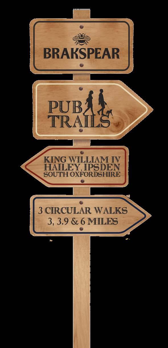
2 How to get there Driving: Postcode is OX10 6AD with a car park for customers. Nearest station: Goring & Streatley station is 5.6 miles away. We re delighted to present three circular walks all starting and ending at the King William IV. The Brakspear Pub Trails are a series of circular walks. We thought the idea of a variety of circular country walks all starting and ending at our pubs was a guaranteed winner. We have fantastic pubs nestled in the countryside, and we hope our maps are a great way for you to get out and enjoy some fresh air and a gentle walk, with a guaranteed drink at the end perfect! Our pubs have always welcomed walkers (and almost all of them welcome dogs too), so we re making it even easier with plenty of free maps. You can pick up copies in the pubs taking part or go to brakspearaletrails.co.uk to download them. We re planning to add new pubs onto them, so the best place to check for the latest maps available is always our website. We absolutely recommend you book a table so that when you finish your walk you can enjoy a much needed bite to eat too. At the weekend, please book in advance, as this is often a busier time, especially our smaller pubs. And finally, do send us your photos of you out and about on your walk. We really do love getting Local bus services: The Thames Travel bus service, routes X39 and X40, stops at Ipsden Turn. From here is it a 1.5 mile walk to the pub. Brakspear would like to thank the Trust for Oxfordshire s Environment and the volunteers who helped make these walks possible. As a result of these walks, Brakspear has invested in TOE2 to help maintain and improve Oxfordshire s footpaths. Reg. charity no Respect - Protect - Enjoy Respect other people: Consider the local community and other people enjoying the outdoors Leave gates and property as you find them and follow paths unless wider access is available Protect the natural environment: Leave no trace of your visit and take your litter home Keep dogs under effective control Enjoy the outdoors: Plan ahead and be prepared Follow advice and local signs For more info visit: publications/the-countryside-code

 Time: 2 hours Route 3: Hailey Nuffield Hailey Distance: 10.")
3 Ridgeway Route 3 Route 2 Wicks Mongewell Bixmoor A4074 Hailey Ipsden Route 1 Berinshill King William IV Hailey, Ipsden Oxfordshire OX10 6AD Tel: Brakspear recommends that all walkers bring a copy of the Chilterns Hills West Ordnance Survey map. You can borrow one from the pub for a refundable 10 deposit. Route 1: Hailey Handsmooth Hailey Distance: 4.8km (3 miles) Time: 1.5 hours Route 2: Hailey Forest Row Ipsden Hailey Distance: 6.3km (3.9 miles) Time: 2 hours Route 3: Hailey Nuffield Hailey Distance: 10.5km (6 miles) Time: 3 hours


4 Route 1 Directions A fairly short walk with a steady climb to start and a shorter steeper climb towards the end. Distance: 4.8km (3 miles) Time: 1.5 hours 01 Turn left from the King William IV car park and walk uphill on the lane for about 1km. As you enter the woodland, ignore a permissive bridleway on the left and continue on for a further 1.5km, taking the left hand fork. 02 As you approach Homer Cottage, turn right through the metal kissing gate, taking the footpath across a field and keeping to the right of overhead power cable route. 03 Go through another kissing gate descending through woodland to Urquhart Lane. As you descend through the woods, you will pass a gate on your right. At this point you will be able to glimpse the side of a large white building (Handsmooth House) commissioned by Rowan Atkinson. 04 At the bottom, turn right and walk along the Urquhart Lane and after about 250m you will pass the entrance to Handsmooth House. If you look back up the hill, you will be able see the complete modernist edifice of the building and make your own judgement on its architectural merit. 05 Continue on this track passing Well Place Farm on the right and Well Place Manor on the left. Bill Nicholls Handsmooth House. The 1930s house, before the modern design was built by Rowan Atkinson. 06 When you reach the junction with the Berins Hill on the left and Well Place Road straight ahead, continue along Well Place Road for about 250m until you reach a footpath on your right. Berins Hill is said to have been the site of a hermitage established by St Birinus who brought Christianity to this area in the 7th century and was the first Bishop of Dorchester. 07 Take the footpath up the side of Warren Hill, passing on your right what was the site of the Well Place Zoo that closed in When you reach the lane turn left and walk downhill to the King William IV Pub. Graham Horn Graham Horn Paddock at Well Place Farm looking towards Handsmooth House. View from Berins Hill. The King William is the small white building at the top left.

 turn left following along the road for about 400m.")
5 Route 2 An easy walk with no steep gradients. Directions Distance: 6.3km (3.9 miles) Time: 2 hours 01 Leave the pub car park and turn right downhill. 02 Walk down the road for 150 metres and turn right on the Chiltern Way Extension. 03 Continue straight ahead on a broad track past Poors Farm then a narrow path through the middle of a field. 04 Enter the woods on a clearly defined path. 05 Emerge from the woods at house Farm and turn left on a tarmac road. 06 When you reach a junction with some cottages on your left (known as Forest Row) turn left following along the road for about 400m. 07 At the T junction, cross the lane and take the footpath opposite. 08 After about 1km you will reach a red and white pole (marking an buried gas pipeline) close to the footpath at Drunken Bottom. This point is close to a spring shown on the OS map and where the Drincan, a winterbourne stream, rises above ground in very wet weather sometimes causing flooding on A After a further 250m cross over the road and continue on the footpath behind Larkstoke House and continue until you reach another small lane. Cross over the lane and follow the footpath into a small copse where you find a small stone memorial. This is in memory of John Thurlow Reade who died in Seharunpore India November 25th It was another member of same family Edmund Reade who through his friendship with the Maharaja of Benares was instrumental in the construction of the Stoke Row Well. Old Vicarage, Ipsden 12 Proceed along the bridleway to the War Memorial and then on to St Mary s Church. 13 Turn right at Ipsden Church and just before the cross roads, go left diagonally on a footpath. The Old Vicarage is a late 17th century Grade 2 listed building. 14 At the road, cross over on to another diagonal footpath and at the road, turn right returning to the King William. St Mary s Church is a very old Church and worth a visit. There is also a well outside that was presented to the community in 1865 by Rajah Sir Deonarayun Singh, K.C.S.I., who followed the example of the Maharajah of Benarese. 10 Retrace your steps and return to the lane and then turn right passing Ipsden Farm and the impressive tithe barn and the grain store opposite. The large tithe barn is a grade 2 listed building and on the opposite side of the road is a traditional grain store. 11 Continue on the road but before you turn left on to the bridleway, continue on just past the bridleway to take a look at the Old Vicarage on the left of the lane. St Mary s Church, Ipsden

6 Route 3 Directions A long a steady climb over the second quarter of the walk, thereafter an easy walk back. Distance: 10.5km (6 miles) Time: 3 hours 01 Leave the pub car park and turn right downhill. 02 Walk down the road for 200 metres and turn right on the Chiltern Way Extension. 03 Continue straight ahead on a broad track past Poors Farm then on to a narrow path through the middle of a field. 04 Enter the woods on a clearly defined path. 05 Emerge from the woods at house Farm and turn left on a tarmac road. 06 When you reach a junction with some cottages on your left (known as Forest Row), turn right and following the Chiltern Way extension along the road. The Chiltern Way is a waymarked long-distance footpath in southern England. The route is circular and runs through the Chiltern Hills region passing through parts of four counties. 07 After 400 metres, turn right and follow the Ridgeway sign through a kissing gate. The Ridgeway is an ancient trackway described as Britain s oldest road. The route was adapted and extended as a National Trail, created in The Ridgeway National Trail follows the ancient Ridgeway from Overton Hill, near Avebury, to Streatley, then follows footpaths and parts of the ancient Icknield Way through the Chiltern Hills to Ivinghoe Beacon in Buckinghamshire. It is 87 miles long. 08 Walk along Grims Ditch with views of the Berkshire Downs to the right. 09 Walk through the trees with a bank on the left which obscures the view on that side. 10 As you walk uphill, you will become more aware of the ditch to your left. 11 Cross a stile and continue to follow the path uphill. 12 Pass through a kissing gate and the path follows the bottom of the ditch in a straight line for 200 metres. 13 Next to a gate and drive leading to a house (called lands Cottage) on the right, pass through a kissing gate and turn left, then turn right immediately on to the Ridgeway. 14 Continue up this path which is now to the left of Grim s Ditch. 15 At one point, this section of path once again descends into the bottom of the ditch. Acabashi, Wikimedia Commons Holy Trinity Church, Nuffield 16 When you reach a junction of paths turn left still following the Ridgeway signs. 17 Follow the path to the right of a five-barred gate and past a large white house to the road. 18 Turn right and, in a few metres, you will reach Holy Trinity Church, Nuffield. 19 Leave the church gate and turn right on the road. 20 At the junction turn right and walk on the pavement and then a grass verge. 21 Opposite a left turn to English Farm, turn right on a footpath (yellow arrow) and walk straight ahead across a field 22 When you reach a cross-track turn left (yellow arrow) and follow a path which after winding around the boundaries of a large house turns sharply right. 23 At the main gate, walk straight ahead across the drive and over the stile. 24 Follow the path along the front of the house and turn left. 25 At the road, walk straight ahead. 26 At the kissing gate, go straight ahead and pass through another kissing gate and walk down the track to Homer Farm. 27 Pass the farmhouse on your left and follow a footpath sign on a tree. 28 At the broad, muddy tarmac road, turn right and walk along this road (almost no traffic), then stay with what has become an unmade road, ignoring the permissive path on the right, for nearly 3km until you arrive back at the King William.
7 King William IV Opening Hours: Mon Fri: 12pm 3pm, 6pm 11pm Sat: 12pm 11pm Sun: 12pm-4pm (winter) 12pm-8pm (summer) Kitchen Open: Mon Sat: 12pm 2pm, 6pm 9pm Sun: 12pm 3.00pm Disabled Access Dog Friendly Family Friendly Garden/Patio Hold a Party Park the Car WiFi Access King William IV Hailey, Ipsden Oxfordshire OX10 6AD Tel: Oswald Bertram Brakspear, The Bull Courtyard, Bell Street Henley-on-Thames, Oxfordshire RG9 2BA info@brakspear.co.uk This info was correct at the time of going to print. Printed April 2017 v1
How to get there. Respect - Protect - Enjoy
 How to get there Driving: Postcode is RG9 3DG and there is a carpark just across from the pub. Nearest station: Henley-on-Thames station is 5.6 miles away. We re delighted to present three circular walks
How to get there. Respect - Protect - Enjoy
 How to get there Driving: Postcode is RG9 5PF and there is a car park just across from the pub. Nearest station: Henley-on-Thames station is 5.6 miles away. We re delighted to present three circular walks
How to get there. Respect - Protect - Enjoy
 How to get there Driving: Postcode is OX49 5HL with a car park for customers Nearest station: Henley on Thames station is 9.5 miles away. We re delighted to present three circular walks all starting and
How to get there. Respect - Protect - Enjoy
 How to get there Driving: Postcode is RG9 6QU and there is a car park for customers. Nearest station: Marlow train station is 7.8 miles away. We re delighted to present three circular walks all starting
10 Miles Circular 5 hours
 VISIT RYEDALE PICKERING AND CAWTHORN CAMPS 10 Miles Circular 5 hours Moderate Terrain 120616 A 10 mile (16km) there and back walk from the market town of Pickering in Ryedale. The route heads north through
9.5 km Circular 3 hours
 MEDIEVAL WAVERLEY Challenging Terrain A 6 mile (9.5km) undulating circular walk from Tilford village passing close to The Sands village and the historic ruins of Waverley Abbey. From the top of Crooksbury
Redesdale Arms. A Trio of Walks
 Redesdale Arms A Trio of Walks Welcome to The Redesdale Arms Hotel The award winning 34 bedroom Redesdale Arms Hotel sits at the gateway to the Cotswolds in the High Street of the historic town of Moreton-in-Marsh.
Slindon Folly - South Downs, West Sussex
 Slindon Folly - South Downs, West Sussex Starts at Park road-side near entrance to Slindon College 2 hours 15 minutes 4.5miles 7.2km Easy ID: 0.1598 Developed by: Chris Mumford Checked by: Rockpit www.ramblersroutes.org
Follow the Lantern Way clockwise from Dursley Town Hall through Cam & Coaley to Uley and back to Dursley (about 14 miles)
") According to the Rev Kilvert's diary of 1873, couples on their way to evening services in winter followed a practical though unusual local tradition: "My Mother says that at Dursley, when ladies and gentlemen
According to the Rev Kilvert's diary of 1873, couples on their way to evening services in winter followed a practical though unusual local tradition: "My Mother says that at Dursley, when ladies and gentlemen
This walk description is from happyhiker.co.uk
 This walk description is from happyhiker.co.uk Pendle Hill Walk From Barley Starting point and OS Grid reference Ordnance Survey map Distance Traffic light rating Barley village honesty box car park OS
Danbury Words and pictures by Laurie Page of the Public Rights of Way team at Essex County Council.
 Danbury Words and pictures by Laurie Page of the Public Rights of Way team at Essex County Council. An undulating walk from Danbury village to the bluebells at the National Trust property of Blakes Wood.
Nuffield, Grim's Dyke, Checkendon, Highmoor
 point your feet on a new path Nuffield, Grim's Dyke, Checkendon, Highmoor Distance: km= miles Region: Chilterns Author: Phegophilos Refreshments: Ipsden, Checkendon, Stoke Row, Nettlebed Map: Explorer
Although the majority of these walks are around country lanes you should still follow the Country Code:-
 With the update of the Parish Plan was a request for details of any Walks around Pillaton The following pages give several walks that I and my wife have done for many years. Please be aware that NONE OF
A circular walk of or km (2 1 4 or miles)
") Grantham A circular walk of 3 3 4 or 5 3 4 km (2 1 4 or 3 1 2 miles) Introduction This relatively short circular walk, which starts in the middle of Grantham, offers plenty of variety. The route takes
Grantham A circular walk of 3 3 4 or 5 3 4 km (2 1 4 or 3 1 2 miles) Introduction This relatively short circular walk, which starts in the middle of Grantham, offers plenty of variety. The route takes
Welsh Newton and Woodland
 Welsh Newton and Woodland This is a 8.2km miles (approx) walk which will take about 2.5 hours at a relaxed and leisurely pace. There are a few hills but no steep inclines. Start at Llangrove bus stop and
Harlington - Sharpenhoe - Pulloxhill
 Harlington - Sharpenhoe - Pulloxhill ID: 3676, Distance: 8 miles, Height gain: 140 Metres, Map: Explorer 193 Luton & Stevenage, Contributor: Dennis Jeanes Duration: 3 Hours 27 Mins Features Church,Great
9.5 km Circular 3 hours
 RANMORE CIRCULAR A 6 mile (9.5km) circular walk from Boxhill and Westhumble Station in the village of Westhumble, passing through part of the Polesden Lacey Estate, Ranmore Common and Denbies Vineyard.
The Mendip Way. Route Directions and Maps Wells to Frome
 The Mendip Way Route Directions and Maps Wells to Frome Website: www.mendiphillsaonb.org.uk Email: mendip@mendiphillsaonb.org.uk Facebook & Twitter: @MendipHillsAONB Phone: 01761462338 1 Wells to Shepton
Bakewell Club Site - Robin Hood's Stride
 Bakewell Club Site - Robin Hood's Stride Camping and Caravanning Route Summary A circular walk with fabulous views winding it's way through the beautiful White Peak scenery. Points of interest include
BALCOMBE AND ARDINGLY RESERVOIR, WEST SUSSEX
 BALCOMBE AND ARDINGLY RESERVOIR, WEST SUSSEX 7 miles Circular 4 hours 080816 Challenging Terrain Hi, I'm Luke and this is my West Sussex Weekends walk It's a 7 mile loop from Balcombe rail station, taking
8 Miles Circular 4 hours
 VISIT RYEDALE HELMSLEY AND RICCAL DALE 8 Miles Circular 4 hours 090616 Challenging Terrain An 8 mile (13km) circular walk from the market town of Helmsley in Ryedale. The route heads out across sheep pastures
THE WELLDIGGERS ARMS, HESWORTH AND FITTLEWORTH TRAIL
 THE WELLDIGGERS ARMS, HESWORTH AND FITTLEWORTH TRAIL 5.5 miles Circular 3 hours 041017 Challenging Terrain A 300-year-old pub turned country-inn on the edge of the South Downs National Park, The Welldiggers
Approximate distance: 10 miles For this walk we ve included OS grid references should you wish to use them. Start. End
 Approximate distance: 10 miles For this walk we ve included OS grid references should you wish to use them. 2 3 Start End 1 N W E S Reproduced by permission of Ordnance Survey on behalf of HMSO. Crown
Walks Around Bishopstone & Hinton Parva
 The Walks: From ½ mile ambles to 8 mile scenic loops Hinton Parva Walks H1 H2 H3 Bishopstone Walks B1 B2 B3 B4 B5 Walk B1: Bishopstone Village, The Dingle (stream) & Pond A short circular village amble
Husthwaite to Byland Abbey
 Husthwaite to Byland Abbey This walk begins with a loop round the village of Husthwaite and continues towards Coxwold along a disused railway line, which is now a right of way. It passes through Coxwold
6.5 km Circular 2 hours
 REIGATE MILLS AND PILLBOXES A 4 mile (6.5km) enjoyable circular walk from Reigate Heath, passing Reigate Heath windmill, Wonham Mill and pillboxes built during the Second World War. 6.5 km Circular 2 hours
THE DOG AND DUCK HAREWOODS ESTATE TRAIL. 6 Miles Circular 3 hours. Getting there. Walk Sections
 THE DOG AND DUCK HAREWOODS ESTATE TRAIL Moderate Terrain A 6 mile circular pub walk from the Dog and Duck in Outwood, Surrey. The Dog and Duck is a delightful pub where everyone is made welcome. From walkers
The Hundred Parishes
 The Hundred Parishes Walks from railway stations number 9 6.4 miles (10kms) from Bishop s Stortford to Stansted Mountfitchet Start: Bishop s Stortford station (Grid Reference TL492209) (ample parking and
Lincolnshire Limewoods Walks. Woodhall Spa. A circular walk of 13km (8 miles)
") Lincolnshire Limewoods Walks Woodhall Spa A circular walk of 13km (8 miles) Introduction The Lincolnshire Limewoods is an area between Wragby, Bardney and Woodhall Spa. It is a fantastic place to explore
Lincolnshire Limewoods Walks Woodhall Spa A circular walk of 13km (8 miles) Introduction The Lincolnshire Limewoods is an area between Wragby, Bardney and Woodhall Spa. It is a fantastic place to explore
RILLINGTON TO MALTON by Tania Dickinson
 RILLINGTON TO MALTON by Tania Dickinson This walk takes you from the Vale of Pickering up on to the Wold scarp, before dropping down again through the pretty village of Settrington and joining the Centenary
Heartwood Forest, in Sandridge, Hertfordshire, is a place where everyone can find space, peace, wildlife and miles of beautiful woodland to explore.
 Heartwood Forest Accessibility Statement September 2016 Purpose: This accessibility statement outlines the available facilities and access information for Heartwood Forest. Welcome We, the Woodland Trust,
Approximate distance: 5.5 miles For this walk we ve included OS grid references should you wish to use them. Start. End
 Approximate distance: 5.5 miles For this walk we ve included OS grid references should you wish to use them. End 4 1 Start 3 2 N W E S Reproduced by permission of Ordnance Survey on behalf of HMSO. Crown
Distance: 5 km=3 miles or 4½ km=2¾ miles or 3½ km=2 miles
 point your feet on a new path Vann Lake Distance: 5 km=3 miles or 4½ km=2¾ miles or 3½ km=2 miles Region: Surrey Author: Schwebefuss Refreshments: Ockley easy walking Date written: 12-feb-2011 Date revised:
LDWA SOUTH DOWNS MARATHON 13 th MAY 2018
 AHD ahead SDW South Downs Way BL/BR bear left/bear right TL/TR turn left/turn right X cross LEG 1 - EAST DEAN to WP1 NORTON GR 470019. Open 1030 to 1300. 9.7 miles. 1.1 From village hall TL and walk to
11 Miles Linear 5 to 6 hours
 11 Miles Linear 5 to 6 hours Sussex Hospices Trail Part 21: BALCOMBE TO HORSHAM Moderate Terrain 030918 An 11 mile linear walk from Balcombe rail station to Horsham rail station in West Sussex, forming
9.5 km Circular 3 hours
 SILENT POOL AND ST MARTHA S HILL Challenging Terrain A 9.5km (6 mile) circular walk in the Surrey Hills, visiting a number of popular attractions including Silent Pool, a stretch of the North Downs Way,
Hammer Vale and Linchmere Common
 point your feet on a new path Hammer Vale and Linchmere Common Distance: 9 km=5½ miles or 6 km=3¾ miles easy walking with one steep section Region: Hampshire, West Sussex Author: Botafuego Refreshments:
Waterhead Pier to Orrest Head, Windermere and Bowness
 Waterhead Pier to Orrest Head, Windermere and Bowness A 4 1 2 hour walk through Woodlands and the Troutbeck Valley with spectacular Lake and Mountain views and a lakeshore path. Walk 10 Walk 11 Walk 12
Stokenchurch. Bluebell Woods, Bomber Memorial, Red Kites, Getty s Cricket Ground, Nature Reserve
 Stokenchurch Bluebell Woods, Bomber Memorial, Red Kites, Getty s Cricket Ground, Nature Reserve Bomber Memorial The best time to visit Cowleaze Wood is in the spring when there is a memorable display of
Hascombe and Winkworth Arboretum Downs Link Path, Smithbrook Kilns
 point your feet on a new path Hascombe and Winkworth Arboretum Downs Link Path, Smithbrook Kilns Distance: 18 km=11 miles Region: Surrey Author: RDC easy walking Date written: 7-may-2016 Last update: 30-aug-2018
HARDMOORS 26.2 WHITE HORSE HALF ROUTE DESCRIPTION - 018
 HARDMOORS 26.2 WHITE HORSE HALF ROUTE DESCRIPTION - 018 Follow Cleveland Way, keeping to the left hand path (right path is a bike trail) Ignoring any turnings to the left or right At path junction (after
Distance: 14 km=8½ miles or 7 km=4½ miles easy-to-moderate walking
 point your feet on a new path Normandy Distance: 14 km=8½ miles or 7 km=4½ miles easy-to-moderate walking Region: Surrey Author: Botafuego Refreshments: Pirbright, Ash date written: 20-feb-2012 date revised:
NEWLANDS CORNER AND ST MARTHAS
 NEWLANDS CORNER AND ST MARTHAS 10k CIRCULAR ROUTE 2½-3HRS GU4 8SE From Newlands Corner on the North Downs just outside Guildford, you can enjoy one of the most beautiful panoramas of quintessential English
The North Pennines from near Langwathby
 3.6 Langwathby to Armathwaite Map panel?? Distance 12.7 miles (20.5 km) Terrain farm, woodland and riverside paths; some potentially muddy tracks; a few short sections of road Grade gently undulating Food
Thornton le Dale Walks
 Thornton le Dale Walks A collection of circular walks in, and around, the village www.visitthorntonledale.co.uk Thornton-le-Dale Traders Forum and Thornton le Dale Parish Council 1 Thornton le Dale Circular
Walk 7: Watchet to washford
 Walk 7: Watchet to washford Length: Moderate - 7.5 miles / 12 km Good For: Theme: History Duration: 2-3 hours depending on speed of walking Notes: This is a moderate to difficult walk in places, with steps,
GENERAL INFORMATION PLEASE FOLLOW THE COUNTRYSIDE CODE:
 KNIGHTON CIRCULAR WALKS The East Radnor Group of the Ramblers Association invites you to enjoy these walks around Knighton. Knighton is an excellent centre for walks in the lovely unspoilt mid-wales countryside
There are toilets at Manningtree Station, Flatford (close to the hump back bridge) and in Dedham.
 and in Dedham.") Arriving by Train Main Features of the Walk Outline Route Employs particularly attractive paths, many of which offer impressive views across Dedham Vale. Includes a section along the tidal section of the
Arriving by Train Main Features of the Walk Outline Route Employs particularly attractive paths, many of which offer impressive views across Dedham Vale. Includes a section along the tidal section of the
Bledlow Beechwoods and Bledda s Rest
 point your feet on a new path Beechwoods and Bledda s Rest Distance: 16 km=10 miles Region: Chilterns Author: Phegophilos Refreshments:, Bennett End moderate walking Date written: 2-sep-2010 Last update:
Clyde Walkway Community Links: Rosebank Circular via Ashgill and Dalserf
 Clyde Walkway Community Links: Rosebank Circular via Ashgill and Dalserf Rosebank Circular via Ashgill and Dalserf Digital Trail Difficulty (out of 3) 1 Distance 7 km / 4.35 miles. Time 2 hours Terrain
Tideswell to Castleton
 Tideswell to Castleton 1 Walk summary Length: 14 km, 8.5 miles Maps: OS Explorer OL1 The Peak District - Dark Peak Area, OS Explorer OL24 The Peak District - White Peak Area, OS Landranger 110 Sheffield
Dyrham and Hinton Parish Walks
 Dyrham and Hinton Parish Walks A series of five walks in the parish, exploring most of the public footpaths. By John Miller Each walk is described in detail, with a complete map, to provide a handy guide
Bix and the Assendons
 point your feet on a new path Bix and the Assendons Distance: 8½ km=5½ miles Region: Chilterns Author: Phegophilos Refreshments: Lower and Middle Assendon Map: Explorer 171 (Chiltern Hills West) hopefully
10 km Circular 3 hours
 FRIMLEY AND FRIMLEY GREEN 10 km Circular 3 hours Easy Terrain 250716 A 10km (6 mile) circular walk exploring the canal towpath, riverside path, woodland, heath and small settlements around Frimley in Surrey.
Walk Description. Directions
 Title: Saffron Trail: Battlesbridge to Chelmsford Distance: 14¾ miles Time taken: 6 hours Start Point: Outside the Barge Inn, Battlesbridge OS Explorer Map: 175 & 183 Grid Ref.: TQ 780 947 Transport: Rail:-
Masson Hill. Walk. Approximately 4 km. Moderate Walk Begins from Matlock Railway Station
 Masson Hill Walk Approximately 4 km Moderate Walk Begins from Matlock Railway Station TOWN WALKS Masson Hill walk is approx. 4 km. It can be walked in a couple of hours or so. Enjoy your walk and the beautiful
Other useful information Nearest Refreshments: In the Victoria Inn or the Lugger Inn, in Chickerell OS Explorer Map: OL15 (Purbeck and South Dorset)
") they find the diamond, and then to Holland, where they try to sell it, finding themselves in worse trouble than ever as a result. It is ten years before John returns to Moonfleet, fortuitously being shipwrecked
they find the diamond, and then to Holland, where they try to sell it, finding themselves in worse trouble than ever as a result. It is ten years before John returns to Moonfleet, fortuitously being shipwrecked
Great Barford and The River Great Ouse
 Great Barford and The River Great Ouse A riverside route which follows the River Great Ouse, with historic sites at Barford Bridge, Danish Camp and Willington Dovecote Essential Facts Route distance: Approximate
The main feature of this tranquil walk is a visit to the source of the Thames (the Thames head) which is in a field just 3 km from Kemble station
 which is in a field just 3 km from Kemble station") SWC Walk DRAFT Kemble circular: the source of the River Thames. The main feature of this tranquil walk is a visit to the source of the Thames (the Thames head) which is in a field just 3 km from Kemble
SWC Walk DRAFT Kemble circular: the source of the River Thames. The main feature of this tranquil walk is a visit to the source of the Thames (the Thames head) which is in a field just 3 km from Kemble
Saltash, Cornwall - Railways, Rivers & Castles
 Saltash, Cornwall - Railways, Rivers & Castles Starts at St Stephen's Church, Saltash, Cornwall 2 hours 45 minutes 5.5miles 8.9km Easy ID: 0.2532 Developed by: Peter Clements Checked by: Kevin Connor www.ramblersroutes.org
Winterfold Wood. point your feet on a new path. In Brief
 point your feet on a new path Winterfold Wood Distance: 8½ km=5¼ miles Region: Surrey Author: Schwebefuss Refreshments: Windmill Inn, Peaslake after the walk moderate walking with many gradients Date written:
ST. AGNES. you cannot put a time limit on beauty.
 ST. AGNES CIRCULAR WALKS AROUND There are many enjoyable and picturesque walks around St. Agnes most are signposted and are featured on the St. Agnes Mini-guide map. Because most of our footpaths are in
5 Miles Circular 2.5 hours
 VISIT RYEDALE KIRKBYMOORSIDE AND ST GREGORY S MINSTER Challenging Terrain A 5 mile (8 km) circular walk from the market town of Kirkbymoorside in Ryedale. The route heads west through open fields and pastures,
Lincolnshire Walks. Ancaster. Three cir cular walks of2 3/4,4or 6km (11/3, 21/2 or 33/4 miles)
") Lincolnshire Walks Ancaster Three cir cular walks of2 3/4,4or 6km (11/3, 21/2 or 33/4 miles) Introduction These walks are set in the attractive countryside around the historic town of Ancaster. The town
Lincolnshire Walks Ancaster Three cir cular walks of2 3/4,4or 6km (11/3, 21/2 or 33/4 miles) Introduction These walks are set in the attractive countryside around the historic town of Ancaster. The town
Pegsdon Hills and The Icknield Way
 Pegsdon Hills and The Icknield Way A country walk generally on the level but with some steep slopes with wide, open views along the ancient Icknield Way Essential Facts Route distance: Approximate time:
Sweetwater and the Holy Well Witley Station, Hambledon, Chiddingfold
 point your feet on a new path Sweetwater and the Holy Well Witley Station, Hambledon, Chiddingfold Distance: 7½ km= miles Region: Surrey Author: Schwebefuss Refreshments: Hambledon, Chiddingfold easy walking
LDWA SOUTH DOWNS MARATHON
 AHD ahead SDW South Downs Way BL/BR bear left/bear right TL/TR turn left/turn right SP signpost/fingerpost X cross LEG 1 - EAST DEAN to WP1 NORTON GR 470019. Open 1030 to 1300. 9.6 miles. 1.1 From village
Thornton le Dale Walks
 Thornton le Dale Walks A collection of walks in and around the village Thornton le Dale Traders Forum www.visitthorntonledale.co.uk Thornton le Dale Walks Walk 1: Beck Isle Cottage and All Saints Church
Lincolnshire Walks. Grainthorpe. Three circular walks of 2 ¾, 9 and 9 ½ km (1 ¾, 5 ½ and 6 miles)
") Lincolnshire Walks Grainthorpe Three circular walks of ¾, 9 and 9 ½ km (1 ¾, ½ and 6 miles) Introduction Explore the coastal marshes, arable hinterland, Louth Navigation canal and the village of Grainthorpe
Lincolnshire Walks Grainthorpe Three circular walks of ¾, 9 and 9 ½ km (1 ¾, ½ and 6 miles) Introduction Explore the coastal marshes, arable hinterland, Louth Navigation canal and the village of Grainthorpe
Walk Description. Directions
 Title: East Hanningfield Distance: 8 miles / 9 miles Time taken: 3-3½ hours Location: 5 miles south east of Chelmsford Parking: Free car park off The Tye, East Hanningfield, next to the primary school
EAST GRINSTEAD AND THE HIGH WEALD, WEST SUSSEX
 EAST GRINSTEAD AND THE HIGH WEALD, WEST SUSSEX 7 miles Circular 3.5 hours 301015 Challenging Terrain Hi, I'm Tom and this is my West Sussex Weekends walk. I live and work in London but often head out of
Dorridge & District Residents Association A Walk Along The Green Belt From Dorridge to Catherine-de-Barnes
 Dorridge & District Residents Association A Walk Along The Green Belt From Dorridge to Carine-de-Barnes The starting section of this walk through open fields would be destroyed by building of motorway
LOCAL CIRCUIT EM1: EAST MALLING & BARMING HEATH. N 2m ROADS: Significant roads PATHS: Starting direction Barming Longsole Mission Church
 Ditton Church Scott Close LOCAL CIRCUIT EM1: EAST MALLING & BARMING HEATH 6 Community Centre F Open fields (see 'Introductory Notes') 1m 88 Direction label (as in the walk notes) East Malling Church -
No. 1 By River Ribble & Brungerley Park 3¼ Miles,
 RVRNEWS 102 No. 1 By River Ribble & Brungerley Park 3¼ Miles, Approx 2 Hours This walk starts at the gate on platform 2 of Clitheroe station. Leaving the station turn left making towards Kirkmoor Rd and
CHINTHURST HILL AND THE GRANTLEY ARMS, SURREY
 CHINTHURST HILL AND THE GRANTLEY ARMS, SURREY 4 miles Circular 2 hours 110417 Challenging Terrain A 4 mile (can be shortened to 3 miles) circular pub walk near Wonersh in Surrey. The walk begins with an
Walk 2: Beamsley Beacon and Bolton Abbey
 Walk 2: Beamsley Beacon and Bolton Abbey Start and Finish: The Memorial Hall, Main Street, Addingham, LS29 0LZ, SE 079 497 The shortest walk is about 5½ miles (8.8km) The medium Walk is about 8¼ miles
Uif!Sfe!Mjpn-!Mpnhepn! bne!dbnnpdl!dibtf-! Tubggpsetijsf
 Uif!Sfe!Mjpn-!Mpnhepn! bne!dbnnpdl!dibtf-! Tubggpsetijsf 7/6!njmft! Djsdvmbs!!!!!!! 4!up!4/6! ipvst Strenuous Terrain Uif!Sfe!Mjpn!jt!b!dmbttjd!wjmmbhf!qvc-!b! hsfbu!qmbdf!up!tbujtgz!zpvs!ivnhfs!bgufs!b!
6 Miles Linear 3 hours
 SPIRES AND STEEPLES Part 2: BRANSTON TO METHERINGHAM 6 Miles Linear 3 hours 160818 Moderate Terrain A 6 mile (10km) linear walk from Branston to Metheringham, forming the second part of the Spires and
Beautiful Walks from the Blue Ball Inn
 Walk No. 7 COAST AND VALLEY WALK Countisbury, Glenthorne, County Gate, Brendon, Rockford and Wilsham 10 MILES APPROX. Walking time 5 hours approx. (not including breaks)> OS Sheet 64/74 Lynton and Lynmouth.
Outwood: oaks, buttercups and windmill
 point your feet on a new path Outwood: oaks, buttercups and windmill Distance: 9 km=5½ miles Region: Surrey Author: Schwebefuss Refreshments: Outwood easy walking Date written: 23-may-2014 Last update:
Sutton Valence or Harrietsham to Pluckley
 Sutton Valence start last checked Harrietsham start last checked Rest of walk last checked 22 April 2018 30 March 2017 3 June 2017 Document last updated: 2 May 2018 This document and information herein
NETTLESTEAD & YALDING
 NETTLESTEAD & YALDING ULL CIRCUIT - Sheet 1 (first and last sections) Open fields (see 'Introductory Notes') 88 Direction label (as in the walk notes) ROADS: 81 10m Significant roads Redhill arm North
Effingham to Westhumble
 Main walk morning last checked Main walk afternoon last checked Pub diversion last checked Westhumble Circular last checked 12 December 2017 23 December 2017 19 August 2015 27 October 2017 Document last
Chapel Point to Anderby Creek
 Coastal Country Park Walks Chapel Point to Anderby Creek A CIRCULAR WALK OF 8.5 OR 6 KM (5.3 OR 3.75 MILES) INTRODUCTION The Lincolnshire Coastal Country Park lies between Sandilands, Chapel St Leonards
SUMMER WALK 10. The Chairmakers, Worlds End
 SUMMER WALK 10 The Chairmakers, Worlds End Tuesday 10 th June 7.30pm This is a very short walk made so due to the majority of the footpaths in the area around the Chairmakers being overrun with high nettles
holly tree Wellhill Farm Woodyard Bramham House red kites Round House ha-ha
 This 6.4 mile walk around the magnificent Bramham Park Estate has been made possible with the active support of the owner of the Estate, Nick Lane Fox, with funding from Natural England, as part of Defra
Clyde Walkway Community Links: Nemphlar Moor Road to Braidwood
 Clyde Walkway Community Links: Nemphlar Moor Road to Braidwood Nemphlar Moor Road to Braidwood Digital Trail Difficulty (out of 3) 2 Distance Main route to Braidwood (shortest) 2.5km, 5km return. Detours
Distance: 9½ km=5¾ miles moderate walking or two walks of 4¼ km=2¾ miles and 6½ km=4 miles
 point your feet on a new path White Hill, Headley Distance: 9½ km=5¾ miles moderate walking or two walks of 4¼ km=2¾ miles and 6½ km=4 miles Region: Surrey Author: Fusszweig Refreshments: Headley Date
THE PONTON PLOD - 27 MILE ROUTE
 THE PONTON PLOD - 27 MILE ROUTE Emergency Phone Number 07771 813514 Abbreviations: BW Bridleway X Cross immd immediately FP Footpath TL Turn left L Left thro through KG Kissing Gate TR Turn right R Right
Oldbury & Littleton, South Gloucestershire
 Oldbury & Littleton, South Gloucestershire Starts at Church Lane, Oldbury. BS35 1QF 2 hours 0 minutes 5.2miles 8.4km Easy ID: 0.2468 Developed by: GEOFF MULLETT Checked by: Marion Stone www.ramblersroutes.org
WETHERBY CIRCULAR by Tania Dickinson
 WETHERBY CIRCULAR by Tania Dickinson This walk in lower Wharfedale includes a disused railway line at the beginning and riverside at the end, with parkland, fields, woodland and villages in between. Distance
TOCKENHAM. Walks for Healthy Living. The Countryside Code (October 2016) Respect other people:
 Respect other people:") The Countryside Code (October 2016) TOCKENHAM Respect other people: consider the local community and other people enjoying the outdoors leave gates and property as you find them and follow paths unless
The Countryside Code (October 2016) TOCKENHAM Respect other people: consider the local community and other people enjoying the outdoors leave gates and property as you find them and follow paths unless
Walking Pembrokeshire.
 Walking Pembrokeshire Canaston Woods Walk It s good to walk, so why not step out and sample some of the walks your neighbourhood has to offer. This pleasant and interesting walk which starts and finishes
Views! village, woodland, hills, high trails, fine houses, hidden church
 point your feet on a new path Heath Distance: 9½ km=6 miles Region: Chilterns Author: Phegophilos Refreshments: easy walking Date written: 13-oct-2017 Map: Explorer 171 (Chiltern Hills West) but this guide
Guildford to Gomshall
 Morning last checked Afternoon last checked Option c) last checked Option d) last checked 9 April 2016 9 April 2016 9 April 2016 23 December 2017 Document last updated: 4 May 2018 This document and information
CHILTERN RAMBLING TRAIL
 CHILTERN RAMBLING TRAIL This route, including a section of the Ridgeway Long Distance Path, offers breathtaking views from the Chiltern ridge. It starts in the Ashridge Estate and returns to Tring via
Ashridge, Dockey Wood, Aldbury, Ridgeway
 point your feet on a new path Ashridge, Dockey Wood, Aldbury, Ridgeway Distance: 13½ km=8½ miles or 7½ km=4½ miles moderate walking with long easy sections Region: Chilterns, Herts Author: Bryntafion Refreshments:
For more information and to buy this book click here ISBN: CICERONE. Guides for walkers, trekkers, mountaineers, climbers and cyclists
 For more information and to buy this book click here ISBN: 9781852845377 CICERONE Guides for walkers, trekkers, mountaineers, climbers and cyclists www.cicerone.co.uk WALK 5 Ouston and Urpeth Distance
Pull the gate towards you and ride through. The third gate takes you onto Hound House Road. Watch out for traffic. 4
 PEASLAKE TO FARLEY HEATH AND WINTERFOLD 12k CIRCULAR ROUTE 2HRS GU5 9QW This interesting trail takes you across a variety of terrain, from the sandstone of Pitch Hill, across open farmland with fabulous
THE BECK STONE Backstone Beck on Ilkley Moor
 THE BECK STONE Backstone Beck on Ilkley Moor 1 Three different routes which take in the best of the lower slopes of Ilkley Moor, with bracken, heather, a tarn (a small mountain lake) and rushing streams.