County of Loudoun. Department of Planning and Zoning MEMORANDUM
|
|
|
- Anastasia Cobb
- 5 years ago
- Views:
Transcription

1 County of Loudoun Department of Planning and Zoning MEMORANDUM DATE: March 16, 2015 TO: FROM: Kate McConnell, AICP, Project Manager Land Use Review Joseph Carter, AICP, CZA, GISP, Senior Planner Community Planning SUBJECT: ZRTD ; St. John s at Loudoun Tech Center BACKGROUND The Applicant, Ridgetop Corporate I, LLC, requests a Zoning Map Amendment Conversion to Current Zoning Ordinance (ZRTD). The subject property is located within the Route 28 Highway Improvement Transportation District (Route 28 Tax District). The Applicant seeks to convert a parcel of approximately 12 acres from PD-IP (Planned Development Industrial Park) under the 1972 Zoning Ordinance to PD-IP (Planned Development Industrial Park) under the Revised 1993 Zoning Ordinance. The parcel is subject to the conditions of SPEX approved by the Board of Supervisors in 1984 and yard setback modifications through ZMAP The applicant is not proposing to supersede either application. The subject site is located in the eastern portion of the County, south of Route 7 at the northwest corner of the eastern most intersection of Nokes Boulevard and Ridgetop Circle (see vicinity map). The subject site is surrounded by office and flex/light industrial uses with access provided via Ridgetop Circle and Horseshoe Drive. The subject site is currently developed with three one-story office buildings. The subject site is planned for Route 28 Business and is envisioned to develop with office and flex-uses at a minimum of two-story buildings with floor area ratios (FAR) between 0.4 to 1.0. Attachment 1a A-1
2 ZRTD ; St. John s at Loudoun Tech Center Community Planning Referral March 16, 2015 Page 2 COMPLIANCE WITH THE COMPREHENSIVE PLAN The subject site is governed by the policies outlined in Loudoun County s Revised General Plan, the Bicycle and Pedestrian Mobility Master Plan (BPMMP), and the Countywide Transportation Plan (CTP). The subject site is located within the Sterling Community of the Suburban Policy Area and within the Route 28 Tax District (Revised General Plan, Chapter 6, Suburban Community Boundaries Map and Route 28 Corridor Plan Planned Land Use Map). The application has been reviewed under the Revised General Plan Suburban Policies of Chapter 6, specifically policies regarding the Route 28 Corridor Plan. Route 28 Business Area is the Planned Land Use for the subject site. ANALYSIS & RECOMMENDATION The County envisions the Route 28 Corridor as a major economic and employment center with predominately commercial development within distinct land development patterns (Revised General Plan, Chapter 6, Route 28 Corridor Plan, Land Use Text). The Route 28 Corridor Plan Land Development Patterns Map identifies the subject site as suitable for Route 28 Business uses (Revised General Plan, Chapter 6, Route 28 Corridor Plan Land Development Patterns Map). The subject site is planned for Route 28 Business (Revised General Plan, Chapter 6, Route 28 Corridor Plan, Route 28 Land Development Patterns Map) which supports up to 100% office and flex uses with floor area ratios (FAR) between 0.4 to 1.0 (Revised General Plan, Chapter 6, Route 28 Corridor Plan, Route 28 Business Area Policies, Policy 1 and 8). The Revised General Plan provides policy direction encouraging property owners within the Route 28 Tax District to convert from the 1972 Zoning Ordinance to the Revised 1993 Zoning Ordinance in order to provide consistent development patterns within the District. The Plan states: The County will look at developing incentives to encourage Route 28 Tax District landowners to opt into the revised zoning ordinance (Revised General Plan, Chapter 4, Economic Development Policy 14). While the PD-IP zoning district allows for uses envisioned for the Route 28 Business areas, the PD-IP district does not necessarily maximize the development potential envisioned for Route 28 Business areas. However, given the subject site is already fully built-out, the proposed conversion to the most current Zoning Ordinance is appropriate. Plan policies support the proposed conversion and Staff recommends approval. cc: John Merrithew, AICP, Acting Director (via ) Cynthia L. Keegan, AICP, Program Manager, Community Planning (via ) A-2
3 County of Loudoun Department of Planning and Zoning MEMORANDUM DATE: March 11, 2015 TO: FROM: CC: Kate McConnell, AICP, Project Manager Andrea Grove, Planner, Zoning Administration Michelle M. Lohr, Deputy Zoning Administrator CASE NUMBER AND NAME: ZRTD St. John s at Loudoun Tech Center TAX/MAP PARCEL NUMBER: /81///8/////C/ /81///8/////B/ MCPI: The applicant is proposing to rezone the above referenced parcels, comprised of approximately 12 acres from Planned Development-Industrial Park (PD-IP) under the 1972 Zoning Ordinance to PD-IP under the Revised 1993 Zoning Ordinance. The property is located within the Route 28 Tax District. The property is subject to SPEX , Loudoun Tech Center Blanket Office Use, approved October 15, 1984, and ZMAP (parking setback modification) approved July 18, The following comments must be addressed for the application to be in conformance with the requirements of the Revised 1993 Zoning Ordinance. 1. A Title Block with application number ZRTD should be added to Sheet 1 of the proposed plan. 2. The Yard Requirements have been included on the proposed plan however, please expand this area to include Lot Requirement Size, Lot Coverage, Building Height and FAR. 3. A note should be added to the proposed plan indicating the subject property is located within the Broad Run District. 4. Include a General Note that the development of the property shall be in conformance to Section Planned Development-Industrial Park (PD-IP) of the Revised 1993 Zoning Ordinance to be placed under the Yards Tabulation given. Attachment 1b A-3
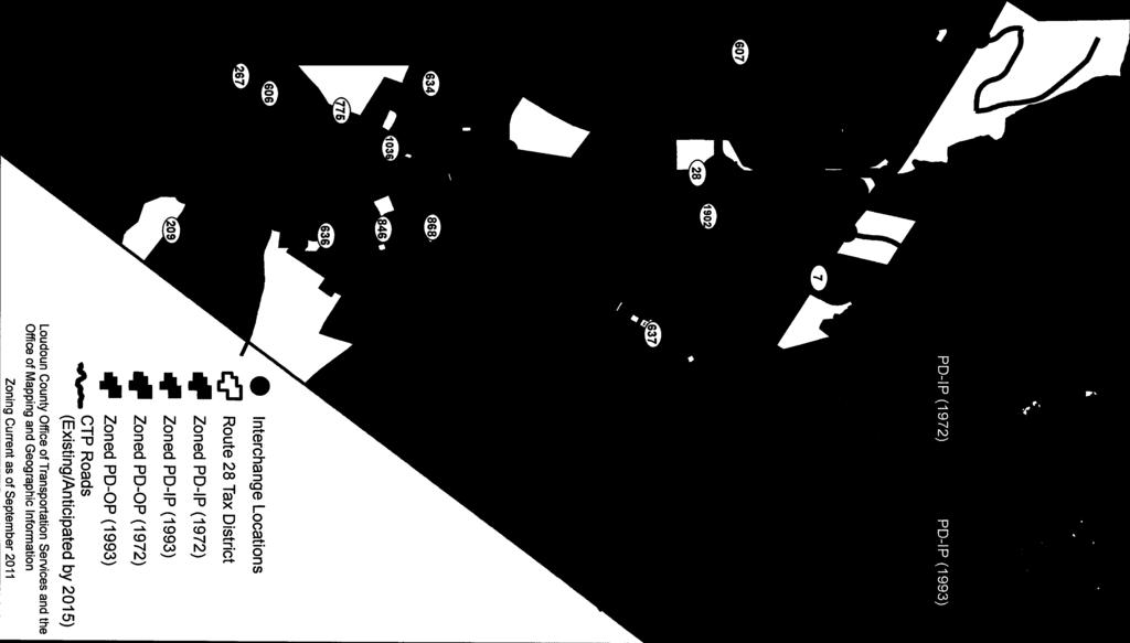
4 County of Loudoun Department of Transportation and Capital Infrastructure MEMORANDUM DATE: March 24, 2015 TO: FROM: Kate McConnell, AICP, Project Manager Department of Planning and Zoning Rory L. Toth, CZA, Senior Transportation Planner DTCI, Transportation Planning & Operations Division SUBJECT: ZRTD St. John s at Loudoun Tech Center First Referral Background This Zoning Map Amendment in the Route 28 Tax District (ZRTD) proposes to rezone two parcels totaling approximately 6.0 acres from the PD-IP (Planned Development Industrial Park) zoning district under the 1972 Loudoun County Zoning Ordinance to the PD-IP zoning district under the Revised 1993 Zoning Ordinance (Zoning Ordinance). The site is located on the north side of Nokes Boulevard (VA Route 1793) west of Cascades Parkway (VA Route 1794) along the eastern most segment of Ridgetop Circle (VA Route 1790). The site currently has three buildings (two on Lot B and one on Lot C) and three access points (one off of Nokes Boulevard, one on Ridgetop Circle and one onto Horseshoe Drive (VA Route 1791) via an ingress/egress easement at the northwest corner of the site. It is also noted that there is interparcel access between Lots B and C via three parking lot drive-aisle connections. A vicinity map is provided as Attachment 1. This review is based on materials received from the Department of Planning and Zoning on February 24, 2015, including (1) an information sheet, dated February 23, 2015; (2) a Concept Development Plan (CDP) ( ZRTD Plat ) prepared by Christopher Consultants, dated December 23, 2014; (3) a Draft Proffer Statement, including redline edits, revised through January 22, 2015; (4) a Statement Request Letter dated December 22, 2014; and (5) the Generalized Traffic Statement for Zoning Map Amendment Applications in the Route 28 Tax District, revised July 2012 (commonly referred to as the Route 28 Generalized Traffic Statement ), which reviews and compares the traffic impacts of various land uses under the 1972, 1993 and Revised 1993 Zoning Ordinances. Compliance with the Countywide Transportation Plan The site is located within the Suburban Policy Area (Sterling Community). The transportation network is specifically governed by the policies of Countywide Transportation Plan (2010 CTP) and the Bicycle & Pedestrian Mobility Master Plan (2003 Bike & Ped Plan). The Department of Transportation and Capital Infrastructure s (DTCI s) assessment of the transportation network is based on review of existing, planned and programmed transportation facilities, review of the Route 28 Generalized Traffic Statement, and applicable County policies. Attachment 1c A-4
5 Existing, Planned and Programmed Transportation Facilities ZRTD St. John s at Loudoun Tech Center DTCI First Referral Comments March 24, 2015 Page 2 The site is located on the north side of Nokes Boulevard (VA Route 1793) west of Cascades Parkway (VA Route 1794) along the easternmost section of Ridgetop Circle (VA Route 1790). Roadways serving the site are described below. Descriptions for planned conditions of CTP roads are taken from Appendix 1 of the 2010 CTP; descriptions of planned bicycle and pedestrian facilities on CTP roads are taken from Appendix 6 of the 2010 CTP and the 2003 Bike & Ped Plan. Nokes Boulevard (VA Route 1793) is classified by the 2010 CTP as a major collector, and runs from Cascades Parkway (VA Routes 637/1794) (opposite Potomac View Road (VA Route 637)) west to Atlantic Boulevard (VA Route 1902). This portion of Nokes Boulevard is constructed to its ultimate condition as an urban four-lane, controlled access, median divided (U4M) roadway. Left- and right-turn lanes are in place in both directions at both unsignalized Ridgetop Circle intersections. In addition, there is an existing right-turn lane on westbound Nokes Boulevard into the southern entrance of the site. According to 2013 Daily Traffic Volume Estimates published by VDOT, Nokes Boulevard carries approximately 20,000 vehicles per day. The 2003 Bike & Ped Plan classifies Nokes Boulevard as a baseline connecting roadway along which bicycle and pedestrian facilities are envisioned. Per Appendix 6 of the 2010 CTP, planned four-lane roads should have one 10-foot wide shared use path (within the ROW or a 14-foot wide easement), one six-foot wide sidewalk, and where feasible, on-road bicycle facilities. Currently, a sidewalk is in place along the north side of Nokes Boulevard to the west of the site, however, there is no sidewalk in place along the site s Nokes Boulevard frontage. An asphalt path is located along the south side of Nokes Boulevard in the vicinity of the site. Ridgetop Circle (VA Route 1790) is a local secondary road that forms a loop and the subject property has frontage on the eastern portion of the loop. It is currently constructed as a fourlane roadway with a two-way center left-turn lane and is not a roadway included in the 2010 CTP network. The eastern most segment of Ridgetop Circle is under stop-sign control at its intersection with Nokes Boulevard. A left-turn lane is also in place at its intersection with Nokes Boulevard. There are no recently published daily traffic counts available from VDOT for this roadway. Ridgetop Circle is referenced in the 2003 Bike & Ped Plan as a baseline connecting roadway along which bicycle and pedestrian facilities are envisioned. Per the 2003 Bike & Ped Plan (Chapter 4, Walkways & Sidewalks Policy 2a), sidewalks are called for along both sides of all local secondary roads. A sidewalk is located along the site s frontage with Ridgetop Circle (western side) and a trail on the eastern side. Horseshoe Drive (VA Route 1791) is a local secondary roadway running in an east-west direction in between the Ridgetop Circle loop and is not a part of the 2010 CTP roadway network. It is currently constructed as a two-lane roadway and is under stop-sign control at both its intersections with Ridgetop Circle. There are no recently published daily traffic counts available from VDOT for this roadway. A-5
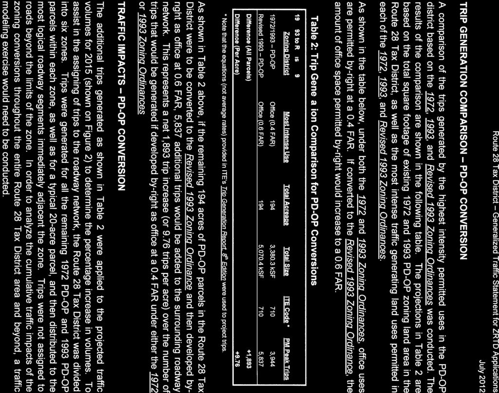
6 ZRTD St. John s at Loudoun Tech Center DTCI First Referral Comments March 24, 2015 Page 3 Horseshoe Drive is not listed in the 2003 Bike & Ped Plan as a baseline connection roadway along which bicycle and pedestrian facilities are envisioned. Currently, there is a trail located along the north side of the roadway and there are no bicycle or pedestrian facilities along the south side of the roadway in the vicinity of the site. Review of Traffic Statement for Route 28 ZMAP Applications to the Current Zoning Ordinance The Route 28 Generalized Traffic Statement included with this application (provided as Attachment 2) was approved by the Board of Supervisors on May 20, 2008 and revised in July The purpose of this generalized traffic statement is to expedite the processing of zoning conversion (ZRTD) applications. The preparation and scoping of a separate traffic study requires additional time and expense prior to the acceptance of rezoning and special exception applications at the initial checklist stage. The use of a ready-made generalized traffic statement, which the Applicant includes with the initial application submittal, helps to facilitate this process. DTCI notes that the Route 28 Generalized Traffic Statement was primarily intended for conversion applications within the PD-OP and PD-IP zoning districts. The Route 28 Generalized Traffic Statement indicates that the signalized intersection of Cascades Parkway (VA 637/1794) and Potomac View Road (VA Route 637) (the nearest intersection to the site included in the generalized traffic statement) operated at LOS C during the AM peak period and LOS D during the PM peak based on traffic data from the timeframe. The generalized traffic statement also forecasts that in the future (2015) this intersection would operate at LOS C in the AM peak period and LOS D during the PM peak. Trip Generation from Proposed Development The application does not limit the development on the site to any particular use. As previously mentioned, there are three existing office buildings located on the subject site. It is understood that the 1972 Loudoun County Zoning Ordinance allows for up to 0.4 FAR of PD-IP uses, which could yield approximately 208,565 square feet on the acre site. It is important to note that under the Revised 1993 Zoning Ordinance, ZOAM was approved on April 2, 2014, which increases the allowable by-right FAR from 0.4 FAR to 0.6 FAR of PD-IP uses, which would yield approximately 312,848 square feet on the acre site. Based on the trip rates published in the Institute of Transportation Engineers (ITE) Trip Generation Report, 9 th Edition, DTCI has developed the following table to show a comparison of trips potentially generated by the most intense traffic generating uses allowed under the 1972 and Revised 1993 Zoning Ordinances. A-6
7 ZRTD St. John s at Loudoun Tech Center DTCI First Referral Comments March 24, 2015 Page 4 Trip Generation Comparison for St. John s at Loudoun Tech Center Maximum Permitted By-Right Uses in the PD-IP Zoning District Revised 1993 Zoning Ordinance ITE Code AM Peak PM Peak Weekday Total 0.6 FAR 100% Office 312,848 SF , Zoning Ordinance 0.4 FAR 100% Office-208,565 SF ,300 Net Difference (Revised 1993 minus 1972) ,151 As shown in the table above, the existing 1972 Zoning Ordinance would permit up to 0.4 FAR of 100% office uses of up to 208,565 square feet. Under the Revised 1993 Zoning Ordinance, the amount of office uses permitted by-right in PD-IP could increase to 0.6 FAR or up to 312,848 square feet. This conversion could yield 163 more AM peak hour, 155 more PM peak hour, and 1,151 more daily vehicular trips than the existing zoning on the property. Transportation Comments DTCI staff has reviewed the Applicant s submitted materials and has the following comments: 1. The specific uses proposed with this application have not been detailed. DTCI understands that zoning conversions typically do not involve a specified land use and that the Board of Supervisors wishes to facilitate the conversions by not requiring detailed plans and studies. Therefore, DTCI is not making specific observations and recommendations regarding traffic impacts for this proposed conversion. 2. Due to the absence of specific development information, the Applicant s concept development plan cannot be evaluated for specific transportation improvements. Therefore, it is unclear what site-specific transportation related improvements may be needed. 3. The Applicant should revise Sheet 1 of the CDP to reflect the existing sidewalk located along the western side of Ridgetop Circle. 4. Per Appendix 6 of the 2010 CTP, pedestrian facilities are called for along all four-lane roadways in the Suburban Policy Area. DTCI recommends that the Applicant commit to a proffer to construct a sidewalk, consistent with the sidewalk located immediately to the west, along the parcel s site frontage with Nokes Boulevard. The proffer should include a trigger stating that the six-foot wide sidewalk should be shown on the first record plat or site plan, whichever comes first in time, prior to its approval. A-7
8 Conclusion ZRTD St. John s at Loudoun Tech Center DTCI First Referral Comments March 24, 2015 Page 5 Due to the general nature of this type of proposal, DTCI has provided comments for information only and, therefore, has no recommendation on this application. ATTACHMENTS 1. Site Vicinity Map 2. Route 28 Generalized Traffic Statement, Revised July 2012 cc: Kathleen Leidich, AICP, Assistant Director, DTCI Lou Mosurak, AICP, Senior Coordinator, DTCI A-8

9 Loudoun County Print Map March 9, 2015 SITE ZRTD , St. John s at Loudoun Tech Center ATTACHMENT 1 A-9


10 A-10
11 A-11
12 A-12
13 A-13
14 A-14
15 A-15
16 A-16


17 A-17


18 A-18

19 A-19
20 A-20


21 A-21


22 A-22


23 A-23


24 A-24

25 A-25
26 A-26
27 A-27


28 A-28
29 A-29


30 Attachment 1d A-30
31 A-31
32 March 27, 2015 Ms. Kate McConnell, AICP Project Manager Loudoun County Department of Planning 1 Harrison Street, SE Leesburg, VA RE: ZRTD St. John s at Loudoun Tech Center Dear Kate: Pursuant to your direction, we are resubmitting herewith five copies of the revised proffer statement and 17 copies of the revised concept plan. Where appropriate, we have revised these documents in accordance with staff comments. Below is a summary of our responses to staff comments. Loudoun County Zoning Administration Memorandum dated March 11, 2015: 1. A Title Block with application number ZRTD should be added to Sheet 1 of the proposed plan. Response: The title and ZRTD number appear in the border information of the CDP. 2. The Yard Requirements have been included on the proposed plan however, please expand this area to include Lot Requirement Size, Lot Coverage, Building Heights and FAR. Response: These items are included. 3. A note should be added to proposed plan indicating the subject property is located within the Board Run District. Response: This is also included in the border information. 4. Include a General Note that the development of the property shall be in conformance to Section Planned Development-Industrial Park (PD-IP) of the Revised 1993 Zoning Ordinance to be placed under the Yards Tabulation given. Response: This note is on the plan sheet. christopher consultants, ltd. voice woodridge parkway, suite 150 fax leesburg, virginia website Attachment 2 A-32
33 Ms. Kate McConnell March 27, 2015 Page 2 DTCI Memorandum dated March 24, 2015: 1. The specific uses proposed with this application have not been detailed. DTCI understands that zoning conversions typically do not involve a specified land use and that the Board of Supervisors wishes to facilitate the conversions by not requiring detailed plans and studies. Therefore, DTCI is not making specific observations and recommendations regarding traffic impacts for this proposed conversion. Response: No response required. 2. Due to the absence of specific development information, the Applicant s concept development plan cannot be evaluated for specific transportation improvements. Therefore, it is unclear what site-specific transportation related improvements may be needed. Response: It is noted regional roads in the vicinity of this site are fully built out. 3. The Applicant should revise Sheet 1 of the CDP to reflect the existing sidewalk located along the western side of Ridgetop Circle. Response: Existing sidewalk added. 4. Per Appendix 6 of the 2010 CTP, pedestrian facilities are called for along all four-lane roadways in the Suburban Policy Area. DTCI recommends that the Applicant commit to a proffer to construct a sidewalk, consistent with the sidewalk located immediately to the west, along the parcel s site frontage with Nokes Boulevard. The proffer should include a trigger stating that the six-foot wide sidewalk should be shown on the first record plat or site plan, whichever comes first in time, prior to its approval. Response: Proffers revised to add a 5 sidewalk along Nokes Boulevard with trigger for construction. If you have any questions or comments regarding the above, please feel free to contact me. Very truly yours, Louis Canonico, P.E. Vice President LC/dml A-33
34 Attachment 3 A-34
35 A-35
36 A-36
37 A-37
38 A-38
Access Management Regulations and Standards
 Access Management Regulations and Standards Efficient highway operation Reasonable property access Concept of Access Management The way to manage access to land development while simultaneously preserving
Access Management Regulations and Standards
 Access Management Regulations and Standards January 2014 Efficient highway operation Reasonable property access Concept of Access Management The way to manage access to land development while preserving
Access Management Regulations and Standards for Minor Arterials, Collectors, Local Streets
 Access Management Regulations and Standards for Minor Arterials, Collectors, Local Streets September 2009 Paul Grasewicz Access Management Administrator Concept of Access Management The way to manage access
Project Description Form 8EE
 Project Description Form 8EE Basic Project Information Submitting Jurisdiction/Agency: Town of Dumfries Project Title: Route 1 (Fraley Blvd) Widening: Brady's Hill Road to Dumfries Road Project Location:
TRAFFIC IMPACT STUDY CRITERIA
 Chapter 6 - TRAFFIC IMPACT STUDY CRITERIA 6.1 GENERAL PROVISIONS 6.1.1. Purpose: The purpose of this document is to outline a standard format for preparing a traffic impact study in the City of Steamboat
Prepared For: Shieldbay Developments Inc. c/o Matson, McConnell Ltd. 2430A Bloor Street West Toronto, Ontario M6S 1P9.
 Prepared For: Shieldbay Developments Inc. c/o Matson, McConnell Ltd. 2430A Bloor Street West Toronto, Ontario M6S 1P9 Prepared By: URS Canada Inc. 4 th Floor, 30 Leek Crescent Richmond Hill, Ontario L4B
FAIRFIELD - RYAN S CORNER TRAFFIC IMPACT ANALYSIS LOUDOUN COUNTY, VIRGINIA
 FAIRFIELD - RYAN S CORNER TRAFFIC IMPACT ANALYSIS LOUDOUN COUNTY, VIRGINIA Submitted on behalf of: Fairfield Residential Prepared by: Wells + Associates, Inc. 1420 Spring Hill Road, Suite 00 McLean, Virginia
APPENDIX G: INTERSECTION NEEDS AT OKEECHOBEE BOULEVARD
 APPENDIX G: INTERSECTION NEEDS AT OKEECHOBEE BOULEVARD INTERSECTION NEEDS AT SR 7 and OKEECHOBEE BOULEVARD SR 7 Extension Project Development and Environment (PD&E) Study From Okeechobee Boulevard (SR
SECTION 1 - TRAFFIC PLANNING
 SECTION 1 - TRAFFIC PLANNING 1.1 TRAFFIC OPERATIONS 1.1.1 Roadway Functional Classification The Multnomah County Comprehensive Framework Plan s Policy 34: Trafficways and the Functional Classification
Sixth Line Development - Transit Facilities Plan
 Memorandum Date: November 13, 2012 To: From: c.c. Subject: Rob Freeman (Freeman Planning) Kevin Phillips Sixth Line Development - Transit Facilities Plan 33016631 This memo was prepared to review the transit
TRAFFIC STUDY GUIDELINES Clarksville Street Department
 TRAFFIC STUDY GUIDELINES Clarksville Street Department 9/1/2009 Introduction Traffic studies are used to help the city determine potential impacts to the operation of the surrounding roadway network. Two
Feasibility Study of Pedestrian Crossings Along Route 7, East of Cascades Parkway and West of Dranesville Road. October 3, 2017
 Feasibility Study of Pedestrian Crossings Along Route 7, East of Cascades Parkway and West of Dranesville Road October 3, 2017 Study Area (area within a ¼-mile radius of the study intersections) Route
Clackamas County Comprehensive Plan
 ROADWAYS The County s road system permits the movement of goods and people between communities and regions, using any of a variety of modes of travel. Roads provide access to virtually all property. They
Roadway Classification Design Standards and Policies. Pueblo, Colorado November, 2004
 Roadway Classification Design Standards and Policies Pueblo, Colorado November, 2004 Table of Contents Page Chapter 1. General Provisions 1.1 Jurisdiction 3 1.2 Purpose and Intent 3 1.3 Modification 3
CarMax Auto Superstore/ Reconditioning Center #6002 Murrieta, California
 CarMax Auto Superstore/ Reconditioning Center #6002 Murrieta, California TUSTIN 17782 17th Street Suite 200 Tustin, CA 92780-1947 714.665.4500 Fax: 714.665.4501 LOS ANGELES 145 S. Spring Street Suite 120
Arterial Management Plan for US Route 250 and State Route 623
 Arterial Management Plan for US Route 250 and State Route 623 June 25, 2014 Brad Shelton, AICP Access Management and Traffic Impact Analysis Programs Manager Transportation and Mobility Planning Division
PROJECT OBJECTIVES. Improve vehicle capacity for the intersection. Improve pedestrian and bicycle access
 COMMUNITY MEETING Project Update March 15, 2010 Purcellville, Virginia OVERVIEW Project need / objectives Project recap Design elements Proposed improvements Summary of project benefits / next steps PROJECT
Shockoe Bottom Preliminary Traffic and Parking Analysis
 Shockoe Bottom Preliminary Traffic and Parking Analysis Richmond, Virginia August 14, 2013 Prepared For City of Richmond Department of Public Works Prepared By 1001 Boulders Pkwy Suite 300, Richmond, VA
4. ENVIRONMENTAL IMPACT ANALYSIS 9. TRANSPORTATION AND TRAFFIC
 4. ENVIRONMENTAL IMPACT ANALYSIS 9. TRANSPORTATION AND TRAFFIC 4.9.1 INTRODUCTION The following section addresses the Proposed Project s impact on transportation and traffic based on the Traffic Study
Villages of Pasadena Hills Financial Plan UPDATED Spring 2012 DRAFT
 36 37 38 39 40 41 42 43 44 45 46 Appendix B (Unchanged from January 2009 Adoption) 47 Projects Approved Prior to VOPH Comprehensive Plan Amendment Ashley Groves Chapel Creek Chapel Hill Farmington Hills
TABLE OF CONTENTS. Executive Summary
 Executive Summary Background... ES-1 Pedestrian Network... ES-2 Bikeway Network... ES-2 Collision History... ES-2 Public Input... ES-4 Conclusions and Recommendations... ES-4 1. Introduction and Setting
CHAPTER 4 TRANSPORTATION IMPACT STUDY TABLE OF CONTENTS
 CHAPTER 4 TRANSPORTATION IMPACT STUDY TABLE OF CONTENTS Section Title Page 4.1 Introduction... 4-1 4.1.1 General... 4-1 4.1.2 Applicant Responsibility... 4-1 4.1.3 Capacity and Safety Issues... 4-1 A.
4.0 TRAFFIC IMPACT STUDIES
 SECTION 4 4.0 TRAFFIC IMPACT STUDIES 4.1 TRAFFIC IMPACT STUDY REQUIREMENTS The City has established Traffic Impact Study (TIS) requirements for the purpose of ensuring that both the quantitative and qualitative
TECHNICAL MEMORANDUM. Introduction
 TECHNICAL MEMORANDUM To: From: John M. Welsh Chris Furlong AHC, Inc. Andrew T. Smith, P.E. Edward Y. Papazian, P.E. Kimley-Horn and Associates, Inc. Date: July 6, 2017 Subject: 200 9 th reet South Redevelopment
MONTGOMERY COUNTY PLANNING DEPARTMENT THE MARYLAND-NATIONAL CAPITAL PARK AND PLANNING COMMISSION
 MONTGOMERY COUNTY PLANNING DEPARTMENT THE MARYLAND-NATIONAL CAPITAL PARK AND PLANNING COMMISSION MCPB Item No. 4 Date: 09-10-15 Scope of Work for the Bicycle Master Plan David Anspacher, Planner/Coordinator,
3.9 Recreational Trails and Natural Areas
 3.9 Recreational Trails and Natural Areas 3.9.1 Introduction Parks and other recreational facilities such as trails, bicycle routes, and open space are important community resources. This section discusses
Lyons Avenue/Dockweiler Road Extension Project Draft Environmental Impact Report. Appendix I Traffic Impact Study
 Lyons Avenue/Dockweiler Road Extension Project Draft Environmental Impact Report Appendix I Traffic Impact Study Street 0 80-1947 500.4501 RITA ld Court 0 91355-1096 400.7401 LA n Avenue 0 590-3745 300-9301
Viewing SMART SCALE Application
 Viewing SMART SCALE Application Route 15 Whites Ferry Road to Points of Rock Bridge Project Status: Submitted Organization: Loudoun County Project ID: 3593 Submitted: 08/06/2018 @ 3:18PM by Bob Brown Created:
Circulation in Elk Grove includes: Motor vehicles, including cars and trucks
 Circulation, as it is used in this General Plan, refers to the many ways people and goods move from place to place in Elk Grove and the region. Circulation in Elk Grove includes: Motor vehicles, including
This chapter describes the proposed circulation system and transportation alternatives associated with
 5.0 Circulation 5.1 OVERVIEW This chapter describes the proposed circulation system and transportation alternatives associated with West Landing, and summarize the information contained in the Existing
Anne Arundel County BICYCLE, PEDESTRIAN, TRANSIT ASSESSMENT GUIDELINES
 Anne Arundel County BICYCLE, PEDESTRIAN, TRANSIT ASSESSMENT GUIDELINES December 2018 TABLE OF CONTENTS I. Executive Summary 3 II. When Is A Bicycle Pedestrian Transit Assessment (BPTA) Required? 4 III.
APPENDIX D COST SUMMARY TABLES
 APPENDIX D COST SUMMARY TABLES Section 1 Between Route 50 and Evergreen Mills Road 3850 linear feet of one 12 foot wide additional lane in southbound direction of Rte 606; from north side of Rte 50 to
CITY OF ALPHARETTA DOWNTOWN MASTER PLAN TRAFFIC EVALUATION
 CITY OF ALPHARETTA DOWNTOWN MASTER PLAN TRAFFIC EVALUATION June 2015 CITY OF ALPHARETTA DOWNTOWN MASTER PLAN TRAFFIC EVALUATION Introduction The Alpharetta Downtown Master Plan was developed in the fall
Chapter 5 Future Transportation
 Chapter 5 Future Transportation The Future Land Use Plan identifies the desired land use designations. The land uses desired for Crozet depend, in large part, on the success of the transportation system,
Marina Loft (DRC 51-R-12)
") Marina Loft (DRC 51-R-12) traffic study prepared for: Cymbal Development OCtober 2012 Traf Tech October 1, 2012 Mr. Asi Cymbal - President Cymbal Development 3470 North Miami Avenue Upper Suite Miami,
Marina Loft (DRC 51-R-12) traffic study prepared for: Cymbal Development OCtober 2012 Traf Tech October 1, 2012 Mr. Asi Cymbal - President Cymbal Development 3470 North Miami Avenue Upper Suite Miami,
Multimodal Through Corridors and Placemaking Corridors
 68 Multimodal Through Corridors and Placemaking Corridors Corridors have different functions in a region. Some corridors are used to get smoothly and rapidly through a region or to get quickly to major
5858 N COLLEGE, LLC N College Avenue Traffic Impact Study
 5858 N COLLEGE, LLC nue Traffic Impact Study August 22, 2016 Contents Traffic Impact Study Page Preparer Qualifications... 1 Introduction... 2 Existing Roadway Conditions... 5 Existing Traffic Conditions...
3.0 Future Conditions
 3.0 Future Conditions In order to be able to recommend appropriate improvements to the transportation system of the Town, it is important to first understand the nature and volume of traffic that is expected
Institute for Real Estate Management Chapter (IREM) 77 VDOT Northern Virginia Megaprojects September 13, 2017
 77 VDOT Northern Virginia Megaprojects September 13, 2017") Institute for Real Estate Management Chapter (IREM) 77 VDOT Northern Virginia Megaprojects September 13, 2017 Susan Shaw, P.E., Megaprojects Director Virginia Department of Transportation Northern Virginia
Institute for Real Estate Management Chapter (IREM) 77 VDOT Northern Virginia Megaprojects September 13, 2017 Susan Shaw, P.E., Megaprojects Director Virginia Department of Transportation Northern Virginia
Appendix B. Transportation Analysis. B.1 Summary. East Nassau Employment Center DSAP
 Appendix B Transportation Analysis B.1 Summary This report presents the transportation analysis completed for the East Nassau Community Planning Area (ENCPA). The ENCPA is defined as 24,000 acres in Nassau
TRAFFIC ACTION PLAN. North Central Neighborhood CITY OF SAN MATEO
 TRAFFIC ACTION PLAN North Central Neighborhood CITY OF SAN MATEO Draft February 2017 Table of Contents Introduction... 1 The Traffic Forum Process... 4 Neighborhood Traffic Issues... 6 Neighborhood Recommendations
10A. DATE: October 5, Pedestrian and Bicycle Advisory Committee. Kevin Colin, Deputy Planning Manager Curt Bates, City Engineer
 10A DATE: October 5, 2016 TO: PREPARED BY: SUBJECT: Pedestrian and Bicycle Advisory Committee Kevin Colin, Deputy Planning Manager Curt Bates, City Engineer Discussion and Provide Comments, Associated
ARTINSVILLE ENRY OUNTY REA RANSPORTATION TUDY
 ARTINSVILLE ENRY OUNTY REA RANSPORTATION TUDY DEVELOPED BY THE TRANSPORTATION AND MOBILITY PLANNING DIVISION OF THE VIRGINIA DEPARTMENT OF TRANSPORTATION IN COOPERATION WITH THE U.S. DEPARTMENT OF TRANSPORTATION,
Transportation Impact Study for Abington Terrace
 Transportation Impact Study for Abington Terrace Abington Township, Montgomery County, PA Sandy A. Koza, P.E., PTOE PA PE License Number PE059911 Prepared by McMahon Associates, Inc. 425 Commerce Drive,
Technical Memorandum TRAFFIC IMPACT STUDY. RIDLEY ROAD CONVENIENCE STORE Southampton County, VA. Prepared for: Mr. David Williams.
 Technical Memorandum TRFFIC IMPCT STUDY RIDLEY ROD CONVENIENCE STORE Southampton County, V Prepared for: Mr. David Williams By: Charles Smith, P.E., PTOE EPR Charlottesville, V July 2014 1 TBLE OF CONTENTS
TRAFFIC ASSESSMENT River Edge Colorado
 TRAFFIC ASSESSMENT River Edge Colorado Submitted by: Fehr & Peers 621 17th Street, Ste. 231 Denver, CO 8293 (33) 296-43 December, 21 App. M-2 Traffic Assessment River Edge Colorado December 21 TABLE OF
TRAFFIC IMPACT STUDY. Creekside Thornton, Colorado. For. August 2015 November 2015 Revised: August Prepared for:
 TRAFFIC IMPACT STUDY For Creekside Thornton, Colorado August 215 November 215 Revised: August 216 Prepared for: Jansen Strawn Consulting Engineers 45 West 2 nd Avenue Denver, Colorado 8223 Prepared by:
Include autoturn exhibits of WB-67 trucks at each roundabout.
 1 Along the through path, the desired relationship is R1>R2
INDUSTRIAL BUILDING 3009 HAWTHORNE ROAD CITY OF OTTAWA TRANSPORTATION OVERVIEW REVISED. Prepared for: Canada Inc.
 INDUSTRIAL BUILDING 3009 HAWTHORNE ROAD CITY OF OTTAWA TRANSPORTATION OVERVIEW REVISED Prepared for: 7849648 Canada Inc. Octiober 1, 2015 114-598 Overview_2.doc D. J. Halpenny & Associates Ltd. Consulting
I-395 Express Lanes Northern Extension Project Crystal City Civic Association September 21, 2016
 I-395 Express Lanes Northern Extension Project Crystal City Civic Association September 21, 2016 Mike Snare, PE, Project Manager Virginia Department of Transportation GEC Michelle Holland, Megaprojects
Overland Traffic Consultants, Inc. October 15, Mr. Bruce McBride Project Delivery Analysts, LLC Shawnee Street Moorpark, CA 93021
 Overland Traffic Consultants 952 Manhattan Beach Boulevard, Suite #100 Manhattan Beach, CA 90266 Phone (661) 799-8423 E-mail: otc@overlandtraffic.com October 15, 2015 Mr. Bruce McBride Project Delivery
MONTGOMERY COUNTY PLANNING DEPARTMENT THE MARYLAND-NATIONAL CAPITAL PARK AND PLANNING COMMISSION
 MONTGOMERY COUNTY PLANNING DEPARTMENT THE MARYLAND-NATIONAL CAPITAL PARK AND PLANNING COMMISSION SHA CTP Project No. MO891A21, US 29, Fairland Road to Musgrove Road Interchange Improvement, Design Review
APPENDIX A: Complete Streets Checklist DRAFT NOVEMBER 2016
 APPENDIX A: Complete Streets Checklist DRAFT NOVEMBER 2016 Complete Streets Checklist MetroPlan Orlando s Complete Streets Checklist is an internal planning tool for staff to further implementation of
New Planning Code Summary: Better Streets Plan and Curb Cut Restrictions
 New ning Code Summary: Better Streets and Curb Cut Restrictions Amended Sections: 138.1, 155(r) and 303(y) Case Number: 2018-008862PCA Board File/Enactment #: 180914/277-18 Initiated by: Supervisors Kim
ADOT Statewide Bicycle and Pedestrian Program Summary of Phase IV Activities APPENDIX B PEDESTRIAN DEMAND INDEX
 ADOT Statewide Bicycle and Pedestrian Program Summary of Activities APPENDIX B PEDESTRIAN DEMAND INDEX May 24, 2009 Pedestrian Demand Index for State Highway Facilities Revised: May 29, 2007 Introduction
Magnolia Place. Traffic Impact Analysis. Prepared for: City of San Mateo. Prepared by: Hexagon Transportation Consultants, Inc.
 Magnolia Place Traffic Impact Analysis Prepared for: City of San Mateo Prepared by: Hexagon Transportation Consultants, Inc. Updated January 4, 2010 Table of Contents 1. Introduction...1 2. Existing Conditions...6
ARLINGTON COUNTY, VIRGINIA
 ARLINGTON COUNTY, VIRGINIA County Board Agenda Item Meeting of October 15, 2016 DATE: October 7, 2016 SUBJECT: Adoption of amendments to the Master Transportation Plan (MTP) to create a new Pedestrian
Basalt Creek Transportation Refinement Plan Recommendations
 Basalt Creek Transportation Refinement Plan Recommendations Introduction The Basalt Creek transportation planning effort analyzed future transportation conditions and evaluated alternative strategies for
Construction Specifications Manual
 Isle of Wight County Pedestrian and Bicycle Master Plan Construction Specifications Manual Adopted August 20, 2009 Introduction The Isle of Wight County Pedestrian and Bicycle Facilities Master Plan was
FI-2 I-66 Between Route 29, Lee Highway and Route 15, James Madison Highway
 TRANSPORTATION PLAN INTENT Transportation is the key to the economic and social development of Prince William County and especially to the I 66/Route 29 Sector Plan area. This includes transportation for
Committed to Service
 Development Services Department Committed to Service TO: FROM: Ada County Highway District Commissioners Mindy Wallace, AICP Planner III COMISSION HEARING: January 27, 2016 SUBJECT: Syringa Valley Specific
Complete Street Analysis of a Road Diet: Orange Grove Boulevard, Pasadena, CA
 Complete Street Analysis of a Road Diet: Orange Grove Boulevard, Pasadena, CA Aaron Elias, Bill Cisco Abstract As part of evaluating the feasibility of a road diet on Orange Grove Boulevard in Pasadena,
Angie Silva Kitsap County Commissioners Office Stef Herzstein, PE, PTOE Transpo Group Jessica Lambert Transpo Group
 DRAFT MEMORANDUM Date: September 30, 2016 TG: 16125.00 To: From: cc: Subject: Angie Silva Kitsap County Commissioners Office Stef Herzstein, PE, PTOE Transpo Group Jessica Lambert Transpo Group Erik Rundell
MEMORANDUM. David Mohlenbrok, Environmental Services Manager
 MEMORANDUM DATE: August 10, 2017 TO: FROM: RE: Planning Commission Members David Mohlenbrok, Environmental Services Manager Blue Memo # 1 for Rocklin Station Project Comments Received on Initial Study/Mitigated
Highway 111 Corridor Study
 Highway 111 Corridor Study June, 2009 LINCOLN CO. HWY 111 CORRIDOR STUDY Draft Study Tea, South Dakota Prepared for City of Tea Sioux Falls Metropolitan Planning Organization Prepared by HDR Engineering,
Cheyenne Metropolitan Planning Organization
 Dell Range Boulevard Corridor Study PHASE II SECTION 20 DRAFT Prepared for: Cheyenne Metropolitan Planning Organization November 20, 2015 (Section 20 is bordered by Powderhouse Road on the west, Storey
MOUNTAIN HOUSE SPECIFIC PLAN I 9.1 INTRODUCTION ASSUMPTIONS TRANSPORTATION FACILITIES TRANSPORTATION IMPROVEMENTS PHASING 9.
 CHAPTER NINE: TRANSPORTATION AND CIRCULATION 9.1 INTRODUCTION 9.1 9.2 ASSUMPTIONS 9.1 9.3 TRANSPORTATION FACILITIES 9.1 9.4 TRANSPORTATION IMPROVEMENTS PHASING 9.3 LIST OF FIGURES LIST OF TABLES Figure
5 CIRCULATION AND STREET DESIGN
 5 CIRCULATION AND STREET DESIGN This chapter describes circulation and streetscape improvements proposed for the Northwest Chico Specific Plan Area. It includes detailed design specifications for existing
LIVERPOOL TRANSPORTATION MODELING TECHNICAL MEMO MAY 2009
 LIVERPOOL TRANSPORTATION MODELING TECHNICAL MEMO MAY 2009 Syracuse Metropolitan Transportation Council 100 Clinton Square 126 N. Salina Street, Suite 100 Syracuse, NY 13202 Telephone (315) 422-5716; Fax
PennDOT Access Management Model Ordinances Training
 PennDOT Access s Training Trainers: Chad Dixson, AICP, TPD Angela Watson, PB Objective of Today Assist Pennsylvania s municipalities and transportation professionals in better understanding the benefits
Figure 1: East West Connector Alignment Alternatives Concept Drawing
 Page 2 of 9 Figure 1: East West Connector Alignment Alternatives Concept Drawing The Montebello Drive extension will run north south and connect Wilsonville Road to the Boones Ferry Road to Brown Road
1609 E. FRANKLIN STREET HOTEL TRAFFIC IMPACT STUDY EXECUTIVE SUMMARY
 1609 E. FRANKLIN STREET HOTEL TRAFFIC IMPACT STUDY EXECUTIVE SUMMARY Prepared for: The Town of Chapel Hill Public Works Department Traffic Engineering Division Prepared by: HNTB North Carolina, PC 343
BPP / SUB
 Development Services Department Project/File: Lead Agency: Site address: Millwell Place Subdivision/ BPP15-0031/ SUB15-0064 This is a preliminary plat application to allow for the development of 68 building
ACHD Board of Commissioners Stacey Yarrington, Planner III Tandem Ridge/ EPP / PP-07-16/ RZ-12-16/ CPA-01-16/ A-07-16
 Development Services Department DATE: December 14, 2016 TO: FROM: SUBJECT: ACHD Board of Commissioners Stacey Yarrington, Planner III Tandem Ridge/ EPP16-0012/ PP-07-16/ Executive Summary: This is an annexation,
SPRINGFIELD REVITALIZATION REPORT
 SPRINGFIELD REVITALIZATION REPORT August 2015 Homewood Suites Springfield Town Center Promenade 2 SPRINGFIELD OVERVIEW This report covers recent development activity in the Springfield Commercial Revitalization
Appendix B. Environmental Resource Technical Memorandum. Assessment on Travel Pattern and Access Impacts
 Appendix B Environmental Resource Technical Memorandum Assessment on Travel Pattern and Access Impacts TECHNICAL MEMORANDUM ENVIRONMENTAL RE-EVALUATION FOR UNION STATION TO OAK CLIFF DALLAS STREETCAR To:
City of Memphis On-Street Parking Modification Guidelines
 City of Memphis Effective Date: December 1, 2013 Bicycle/Pedestrian Program 125 N. Main Street Memphis, TN 38103 (901) 576-6710 www.bikepedmemphis.com City of Memphis Executive Summary It is current practice
CastleGlenn Consultants Inc.
 February 1 st, 2010 CastleGlenn Consultants Inc. Engineers, Project Managers & Planners Mr. Kevin Yemm Planning and Land Development Richraft Ltd. 2280 St. Laurent Boulevard Suite 201 Ottawa, Ontario (Tel:
STAFF REPORT. Comprehensive Plan Amendment CPA #PLN
 COUNTY OF PRINCE WILLIAM 5 County Complex Court, Prince William, Virginia 22192-9201 PLANNING (703) 792-7615 FAX (703) 792-4401 OFFICE www.pwcgov.org Christopher M. Price, AICP Director of Planning STAFF
This page intentionally left blank.
 This page intentionally left blank. COMMUNITY Coweta Community Overview Coweta Coweta, a residential community located in Wagoner County, is a suburb of Tulsa situated southeast of the metropolitan area
Glenn Avenue Corridor Traffic Operational Evaluation
 Glenn Avenue Corridor Traffic Operational Evaluation PREPARED FOR: THE CITY OF AUBURN PREPARED BY: DECEMBER 2007 Glenn Avenue Corridor Study--Auburn, Alabama TABLE OF CONTENTS Introduction... 1 Background
Road Alterations - Wellington Street East, Church Street, and Front Street Intersection
 REPORT FOR ACTION Road Alterations - Wellington Street, Church Street, and Front Street Intersection Date: November 1, 2016 To: Toronto and York Community Council From: Director, Public Realm Section,
Peer Review of Highlands Neighborhood Traffic and Pedestrian Safety Plan
 FINAL REPORT March 14, 2017 Prepared for: Ada County Highway District Prepared by: SIX MILE ENGINEERING, PA Executive Summary The (Highlands Safety Plan) developed by the Ada County Highway District (ACHD)
Project Description Form 6V
 Project Description Form 6V Basic Project Information Submitting Jurisdiction/Agency: Prince William County Project Title: Route 15 Widening: Route 55 to south of RR tracks & Construct RR Overpass Project
I-395 Express Lanes Northern Extension Project Fairlington Citizens Association September 12, 2016
 I-395 Express Lanes Northern Extension Project Fairlington Citizens Association September 12, 2016 Susan Shaw, PE, Megaprojects Director, Virginia Department of Transportation Amanda Baxter, Special Projects
Summary: Mercer County Princeton Avenue & Spruce Street Study January 2009
 Summary: Several recent studies have assessed potential development and redevelopment opportunities in the Mercer Crossing area of Trenton, Ewing, and Lawrence. This Princeton Avenue and Spruce Street
Durrance Elementary School
 Durrance Elementary School SCHOOL ROUTE PLAN For DURRANCE ELEMENTARY SCHOOL LOCATION 9 ORANGE COUNTY Prepared for: ORANGE COUNTY SCHOOL ASSESSMENT PROGRAM ORANGE COUNTY PUBLIC WORKS Traffic Engineering
APPENDIX I: ROADWAY CLASSIFICATION SYSTEM AND PROJECT CONSISTENCY STANDARDS
 APPENDIX I: ROADWAY CLASSIFICATION SYSTEM AND PROJECT CONSISTENCY STANDARDS The Santa Barbara County Comprehensive General Plan Circulation Element Policy A states that: "The roadway classifications, intersection
Urban Planning and Land Use
 Urban Planning and Land Use 701 North 7 th Street, Room 423 Phone: (913) 573-5750 Kansas City, Kansas 66101 Fax: (913) 573-5796 Email: planninginfo@wycokck.org www.wycokck.org/planning To: From: City Planning
Corridor Recommendations and Implementation
 Corridor Recommendations and Implementation INTER-PARCEL CONNECTIVITY Both alternative Concept A and Concept B segments of the Community Core suggest a system of interconnected local streets and local
Frequently Asked Questions
 Frequently Asked Questions The Access Management Regulations 24 VAC 30-73 and Appendix G Design Standards Minor Arterials, Collectors, Local Streets November 2009 Land Development Section Central Office
INNER LOOP EAST. AIA Rochester Annual Meeting November 13, 2013 TRANSFORMATION PROJECT. Bret Garwood, NBD Erik Frisch, DES
 INNER LOOP EAST TRANSFORMATION PROJECT AIA Rochester Annual Meeting November 13, 2013 Bret Garwood, NBD Erik Frisch, DES Why? We are building a city that encourages walking, biking and enjoying the outdoor
Route 7 Corridor Study
 Route 7 Corridor Study Executive Summary Study Area The following report analyzes a segment of the Virginia State Route 7 corridor. The corridor study area, spanning over 5 miles in length, is a multi
APPENDIX F SUPPLEMENTAL TRAFFIC DATA
 APPENDIX F SUPPLEMENTAL TRAFFIC DATA Environmental and Planning Consultants 440 Park Avenue South 7th Floor New York, NY 10016 tel: 212 696-0670 fax: 212 213-3191 www.akrf.com Draft Memorandum To: Michael
Route 29 Corridor Assessment Update. Development of Possible Solutions
 Route 29 Corridor Assessment Update Development of Possible Solutions Public Workshop #3 October 27, 2016 Purpose of Developing Possible Solutions Recap of where we ve been and timeline for moving forward
Appendix C. NORTH METRO STATION AREA TRAFFIC IMPACT STATEMENT 88th Avenue Station
 Appendix C NORTH METRO STATION AREA TRAFFIC IMPACT STATEMENT 88th Avenue Station Prepared for: Regional Transportation Department and URS Corporation as part of the North Metro EIS David Evans and Associates,
City of Fairfax, Virginia City Council Work Session
 City of Fairfax, Virginia City Council Work Session Agenda Item # City Council Meeting 12a 9/8/2015 TO: FROM: SUBJECT: ISSUE(S): SUMMARY: FISCAL IMPACT: RECOMMENDATION: ALTERNATIVE COURSE OF ACTION: RESPONSIBLE
City of Homewood Transportation Plan
 City of Homewood Transportation Plan Prepared for: City of Homewood, Alabama Prepared by: Skipper Consulting, Inc. May 2007 TABLE OF CONTENTS INTRODUCTION... 1 BACKGROUND INFORMATION... 1 EXISTING TRANSPORTATION
ALLEY 24 TRAFFIC STUDY
 ALLEY 24 TRAFFIC STUDY in City of Frostburg, Maryland January 2013 3566 Teays Valley Road Hurricane, WV Office: (304) 397-5508 www.denniscorporation.com Alley 24 Traffic Study January 2013 Frostburg, Maryland
VDOT BICYCLE & PEDESTRIAN IMPLEMENTATION GUIDE FOR LOCALITY INVOLVEMENT April 2017
 VDOT BICYCLE & PEDESTRIAN IMPLEMENTATION GUIDE FOR LOCALITY INVOLVEMENT April 2017 1 TABLE OF CONTENTS Topic Page(s) About this Guide 3 Encouraging development of bicycle and pedestrian plans by localities