Thesis Presentation. Moorhead City Walk: A Master Plan to Reimage Moorhead, Minnesota s Urban Core. Brad Garcia Advisors: Jason Kost & Dominic Fischer
|
|
|
- Kerry Quinn
- 5 years ago
- Views:
Transcription
1 Thesis Presentation Moorhead City Walk: A Master Plan to Reimage Moorhead, Minnesota s Urban Core Brad Garcia Advisors: Jason Kost & Dominic Fischer


2 MOORHEAD, MN Red River Center Ave 8 TH St N FARGO, ND Fargo/Moorhead MOORHEAD, MN Google Earth 2

3 Moorhead Center Mall City Hall FOCUS AREA Red River US Bank 5 th St N PROJECT AREA 8 TH St N KO Railroad Line Moorhead, MN Google Earth 3
4 Center Ave History Moorhead, MN Center Ave Bridge (1965) (1934) Old Falls Street buildings had typical main street brick architecture. ghostsofminnesota.com Urban Renewal (1968) An urban renewal plan was approved in 1966 but deconstruction of downtown buildings didn t begin until mnstate.edu Moorhead Center Mall Construction on the mall began in 1972 and was completed in


5 Center Ave Today Moorhead, MN Center Ave Parking lots and brick walls line Center Ave, restricting most retail activity inside the Moorhead Center Mall. Moorhead Center Mall Even with an abundance of parking, the mall has difficulty in attracting tenants. Moorhead City Hall is buried in the center. Streetscape Reconstruction A successful redevelopment of 4 th St & Main Ave and streetscape was thought to be the catalyst for development. 5

6 GREEN What makes a Streetscape Successful? MULTI- MODAL Image: Indianapolis Cultural Trail (landscapevoice.com/) 6

7 What makes a Streetscape Successful? INVESTMENT HISTORY Image: Times Square- New York, NY (orensanzfortheartsnyc.org) 7

8 CULTURE What makes a Streetscape Successful? USE Image: Pine Street- Warrensburg, MO (digitalburg.com) 8


9 Streetscape Environments economic political social natural 9

10 Streetscape Environments INFLUENCERS DEVELOPMENT CORP. INVESTMENT VALUE RETAIL DEVELOPMENT BUSINESS CLIMATE CODE TAXES economic political FUNDING LAWS INFRASTRUCTURE PLANNING EVENTS INTERACTION CULTURE SHOPPING TOURISM FAMILY social TECHNOLOGY ENTERTAINMENT HISTORY USE natural WILDLIFE PARKS WATER NATURAL SYSTEMS SUN TREES STORMWATER 10

11 Streetscape Environments ACTORS DEVELOPMENT CORP. INVESTMENT VALUE RETAIL DEVELOPMENT BUSINESS CLIMATE CODE TAXES economic political FUNDING LAWS INFRASTRUCTURE PLANNING EVENTS INTERACTION CULTURE SHOPPING TOURISM FAMILY social TECHNOLOGY ENTERTAINMENT HISTORY USE natural WILDLIFE PARKS WATER NATURAL SYSTEMS SUN TREES STORMWATER 11
12 NIAGARA FALLS, NY A CASE STUDY 12
13 Old Falls Street Niagara Falls, NY Old Falls Street and Riverway Urban Renewal (1971) Rainbow Centre Mall (1982) (1934) Old Falls Street buildings had typical main street brick architecture. Scale Model of proposed $160 million redevelopment project. Fountains and plantings made the mall a vibrant place to shop. architecture.desktopnexus.com/ wakeupniagara.weebly.com/ uli.org 13
14 Old Falls Street Niagara Falls, NY Old Falls Street Looking East with the Casino in the background. The Casino originally was the convention center. citylab.com/ Rainbow Centre Mall Close to 300,000 square feet of retail space, the mall currently is anchored by Niagara County Community College s Culinary Institute. bizjournals.com Streetscape Reconstruction Firm: DIDONATO Amount: $2.8 million Completed: 2007 didonato.cc 14


15 NIAGARA FALLS, NY A CASE STUDY 15


16 What Happened? economic political social natural 16


17 So, What is the Right Combination? economic political economic political social natural economic political social natural social natural 17


18 But Environments change 18

19 Moorhead City Walk DESIGN GOALS Design an evolving Streetscape Establish Primary Corridor(s) Identify primary road(s) as the epicenter of redevelopment. New Development Propose infill development while maintaining existing structures, focusing on publicly held land as a catalyst for the overall project. Streetscape Framework Establish zones to accommodate outdoor retail, pedestrian circulation, bicycle circulation, vehicle and transit circulation, plaza space, and street development. Branding Develop streetscape amenities and event programming to connect all components of the streetscape framework and surrounding community. Renovate Moorhead Center Mall Utilize the existing Moorhead Center Mall as a backbone to the retail corridor. Connect to the River Strengthen the connection of the Red River to downtown Moorhead. 19

20 Moorhead City Walk CORRIDOR Boardwalk Lifestyle Center Plaza 5 th ST Pedestrian Mall Center Ave Corridor 20

21 Moorhead City Walk CORRIDOR Pedestrian Bridge Center Plaza 4 th St Entry 5 th St Entry 21


22 Moorhead City Walk CORRIDOR ENTERTAINMENT ZONE RETAIL ZONE TRANSITION ZONE Pedestrian Bridge Center Plaza 5 th St Pedestrian Mall Center Ave Corridor 22


23 Moorhead City Walk CENTER AVE BUSINESS FRAMEWORK Generative Business Can be an anchor tenant, this type of business generates customer traffic through its own branding, advertising or reputation. Shared Business Shared business activity occurs by attracting a customer base from some other source, such as a popular destination or a nearby generative business. Sucipient Business Business activity that occurs mostly by chance or convenience. Some specialty brick and mortar businesses may fall into this category. 23
24 Moorhead City Walk CENTER AVE STREETSCAPE FRAMEWORK 24


25 Moorhead City Walk CENTER AVE STREETSCAPE FRAMEWORK Wide Urban Space for Generative Business 25

26 Moorhead City Walk 5 th STREET PEDESTRIAN MALL FRAMEWORK 26
27 Moorhead City Walk 5 th STREET PEDESTRIAN MALL FRAMEWORK Collectively, the Moorhead City Walk becomes a destination for residents and tourists which support peripheral businesses. 27


28 Moorhead City Walk MASTER PLAN ZONES: RETAIL SIDEWALK FLEX PUBLIC US Bank City Hall Main Ave Bridge Moorhead Center Mall 28

29 New Facade to Mall Convert to Hotel ENTERAINMENT PLAZA Looking East down Center Ave 29

30 Pedestrian Bridge Performing Arts Center ENTERAINMENT PLAZA Looking West to Fargo 30

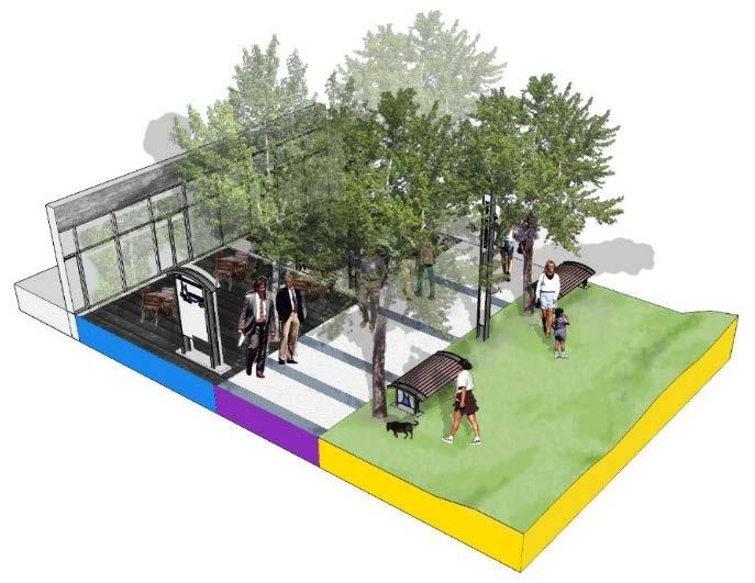
31 Moorhead City Walk STREETSCAPE SITE PLAN 31

32 Moorhead City Walk STREETSCAPE SITE PLAN 34

33 Moorhead City Walk STREETSCAPE SITE PLAN 37

34 Office & specialty services on upper floors Modern era Architecture Retail on ground level Shopping Corridor Looking Southeast 38

35 Moorhead City Walk PEDESTRIAN MALL SITE PLAN 39


36 Moorhead City Walk STREETSCAPE SITE PLAN Retail Plaza Seasonal Use Residential Plaza 40

37 Formal City Hall Entrance Space for a variety of Markets City Hall Square Looking Northeast 41
38 Moorhead City Walk BRANDING Simple modern design Lighting Adjustable lighting allows lighting fixtures to be adaptable to streetscape activity. Sound Speakers can broadcast nature sounds, social activities and Christmas music during the holidays. Signage The City Walk Logo is backlit and changes colors depending on the time of day and season to enhance the ambience. Benches A warmer touch is added to the benches by adding a curved wood seat. The alternate city walk logo is backlit. Removable for repositioning within the streetscape 42


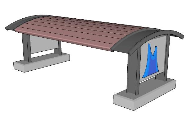
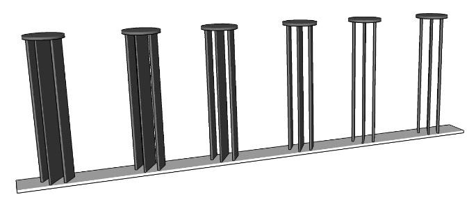
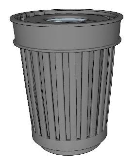
39 Moorhead City Walk BRANDING Lighting Bike Rack Signage Bench Garbage Retail Kiosk Bollard Planters 43

40 What makes a Streetscape Successful? economic social political natural 45


41 Niagara Falls Case Study Niagara Falls, NY is an excellent case study, as the city went through Urban Renewal, has a blighted downtown mall and has recently completed a new streetscape Streetscape Framework Establish zones to accommodate outdoor retail, pedestrian circulation, bicycle circulation, vehicle and transit circulation, plaza space, and street development. Design Goals Several goals of this project seek to create an adaptive streetscape which can evolve, adding layers of culture, history, and nature through time. Master Plan The Moorhead City Walk master plan shows the potential of downtown Moorhead. Implementation will take several years, if not decades Center Avenue Streetscape The primary corridor of the Moorhead City Walk. Center Avenue connects with Fargo s NP Avenue and the Red River, creating a complementary downtown experience. 5 th Street Pedestrian Mall 5 th Street Pedestrian Mall becomes the urban marketplace for a variety of uses. The mall also creates a formal doorstep for the city s government building. DESIGN GUIDELINES Questions? 46
Enhancing Downtown
 Enhancing Downtown 2014-2015 Process Masterplan reviewed TIF scope, fund availability, and timing Conceptual cost estimate stage things may change with full engineering Sequencing Coordination with businesses
DALLAS MIDTOWN REDEVELOPMENT PLAN FOCUS NORTH TEXAS Peer Chacko, AICP, Assistant Director, City of Dallas
 DALLAS MIDTOWN REDEVELOPMENT PLAN FOCUS NORTH TEXAS 2014 Peer Chacko, AICP, Assistant Director, City of Dallas Dallas Midtown: Strategic growth area Future transit node 2 Peterson Road Study Area Galleria
S T A T I O N A R E A P L A N
 The Circulation and Access Plan describes vehicle, pedestrian, and transit improvements recommended within the Concept Plan. In order to create and sustain a vibrant business district that provides pedestrian-friendly
WELCOME. Purpose of the Open House. Update you on the project. Present a draft recommended plan. Receive your input
 WELCOME Purpose of the Open House The Town of Smiths Falls has initiated the Beckwith Street Redevelopment Plan that includes the preparation of a streetscape functional design for the renewal of Beckwith
Obey Creek PEDESTRIAN CIRCULATION EAST WEST PARTNERS PEDESTRIAN CIRCULATION CREEK SIDE LANE SLIP STREET SCOTT MURRAY MAIN STREETS EAST/WEST
 THE VILLAGE AT PEDESTRIAN CIRCULATION MAIN STREETS NORTH/SOUTH MAIN STREETS EAST/WEST SLIP STREET CREEK SIDE LANE PEDESTRIAN CIRCULATION DESCRIPTION: Circulation through the downtown of is organized by
Table #6 VISION CHARACTERISTICS
 Table #6 VISION White Flint is a place to live, work, play, shop, and walk with sufficient density to encourage quality redevelopment. Vibrant streets and consistent streetscapes are important. CHARACTERISTICS
PUBLIC REALM MASTER PLAN
 WESTSHORE BUSINESS DISTRICT PUBLIC REALM MASTER PLAN MASTER PLAN COMMITTEE MEETING MARCH 20, 2013 WESTSHORE BUSINESS DISTRCT PUBLIC REALM MASTER PLAN MACRO-SCALE CONCEPT: A PUBLIC REALM FRAMEWORK DEFINED
Illustrated Principles of Good Planning
 Illustrated Principles of Good Planning The Miami 21 Zoning Code incorporates time-tested planning principles into the zoning regulations of our City. These are principles that make for better neighborhoods,
2.0 Ballpark District
 2.0 Ballpark District 2.1 Introduction The Ballpark District is located in the south central portion of the City of Lake Elsinore, just north of the City limit line in this area. The Ballpark District
A CHANGING CITY. of Edmonton, it is essential that it reflects the long-term vision of the City.
 A CHANGING CITY By the year 2040, Edmonton will be home to more than 1 million people. To accommodate growth and support a healthy and compact city, we need a new approach to development/redevelopment
7 Complete Streets & Roadway Aesthetics
 7 Complete Streets & Roadway Aesthetics 7.1 OVERVIEW Our streets lay the foundation for how we interface with travel needs, physical exercise, social exchanges and access to goods and services. They are
CONNECTIVITY PLAN. Adopted December 5, 2017 City of Virginia Beach
 CONNECTIVITY PLAN Adopted December 5, 2017 City of Virginia Beach CONTENTS 1.0 Background & Purpose... 2 2.0 Existing Inventory & Analysis... 3 ViBe District Existing Walking Conditions... 4 3.0 ViBe District
Cherry Creek Transportation and Land Use Forum September 25, 2013 Meeting Summary
 Cherry Creek Transportation and Land Use Forum September 25, 2013 Meeting Summary I. LEAD-IN TO SMALL GROUP DISCUSSION, POLLING AND STEERING COMMITTEE/TECHNICAL TASK FORCE DISCUSSION The meeting began
SPRINGFIELD REVITALIZATION REPORT
 SPRINGFIELD REVITALIZATION REPORT August 2015 Homewood Suites Springfield Town Center Promenade 2 SPRINGFIELD OVERVIEW This report covers recent development activity in the Springfield Commercial Revitalization
ATTACHMENT 4 - TDM Checklist. TDM Checklist Overview
 ATTACHMENT 4 - TDM Checklist TDM Checklist Overview The proposed checklist rates developments on the degree to which they are TDM and transit supportive. Points are assigned based on the level of transit
STONY PLAIN ROAD STREETSCAPE
 Jasper Place Revitalization Strategy: Vision The people involved in the Jasper Place Revitalization Strategy envision: Goal 1: Feeling safe in our community Create a community where feeling safe is common--where
EXECUTIVE SUMMARY: TRANSIT-ORIENTED DEVELOPMENT IN SMITHS FALLS, ONTARIO; A COMPARISON BETWEEN TWO SITES
 EECUTIVE SUMMARY: TRANSIT-ORIENTED DEVELOPMENT IN SMITHS FALLS, ONTARIO; A COMPARISON BETWEEN TWO SITES Topic and Purpose In 2007, the Mayor of Ottawa s Task Force on Transportation suggested adding a
Proposed. City of Grand Junction Complete Streets Policy. Exhibit 10
 Proposed City of Grand Junction Complete Streets Policy Exhibit 10 1 City of Grand Junction Complete Streets Policy Vision: The Complete Streets Vision is to develop a safe, efficient, and reliable travel
5 Circulation & Parking
 5 Circulation & Parking Downtown Parking & Circulation Strategy. Downtown Wayne has a somewhat disconnected system of local public streets to connect downtown with the residential neighborhoods, and primary
Montco 2040 Implementation Grant Program Award Summary
 Municipality Montco 2040 Implementation Grant Program - 2017 Award Summary Support Downtowns Walk/Bike Montco Name of Project Business Parks Total Project Cost Grant Award Schwenksville Main Street Pedestrian
integrated action plan
 public presentation. june 24, 2009. city of portsmouth, nh islington corridor integrated action plan richardson & associates, landscape architects evan haynes, public arts consultant Islington Street Corridor
RIVERSIDE, Newton MA BH NORMANDY RIVERSIDE LLC. Riverside Station. A green, transit-oriented community
 Riverside Station A green, transit-oriented community October 6, 2011 TONIGHT S AGENDA: 1. Project Update (5 min.) 2. Master Plan Update (10 min.) 3.Traffic Plan Update (10 min.) Questions & Answers MASTER
Bicycle and Pedestrian Advisory Committee (BPAC) November 21, 2013
 November 21, 2013") Bicycle and Pedestrian Advisory Committee (BPAC) November 21, 2013 OVERALL LAND USE CONCEPT Overall Broadway Valdez District: 95.5 acres (35.1 acres right-of ways + 60.4 acres developable land) Plan Subareas:
Bicycle and Pedestrian Advisory Committee (BPAC) November 21, 2013 OVERALL LAND USE CONCEPT Overall Broadway Valdez District: 95.5 acres (35.1 acres right-of ways + 60.4 acres developable land) Plan Subareas:
Vision: Traditional hamlet with an attractive business/pedestrian friendly main street connected to adjacent walkable neighborhoods
 N D. Focus Area II Vision: Traditional hamlet with an attractive business/pedestrian friendly main street connected to adjacent walkable neighborhoods Transit Road Focus Area II is located in the Hamlet
In station areas, new pedestrian links can increase network connectivity and provide direct access to stations.
 The Last Mile Planning for Pedestrians Planning around stations will put pedestrians first. Making walking to stations safe and easy is important; walking will be a part of every rapid transit Accessible
Ann Arbor Downtown Street Plan
 1 Ann Arbor Downtown Street Plan Public Workshop #1 We know that. 2 Public right-of-way (streets, sidewalks, and alleys) make up 30% of the total District area of downtown. Streets need to provide mobility
City of Darlington Beautification Report
 City of Darlington Beautification Report Approved by the City of Darlington Beautification Board February 2016 The New Downtown Darlington has seen many changes during the past decade with the rehabilitation
Streetscape: Core Shopping District
 Streetscape: Core Shopping District DRAFT DRAFT DRAFT May 00 Core Shopping District: Phase Blue Island s Core Shopping District is located along Western Avenue, between Grove and Union Streets. Streetscape
5. Automobile Circulation, Wayfinding and Signage
 5. Automobile Circulation, Wayfinding and Signage Policy: The City Center should have a balanced, safe, and interconnected circulation system that provides expanded travel opportunities for transit, pedestrian,
Tonight is for you. Learn everything you can. Share all your ideas.
 Strathcona Neighbourhood Renewal Draft Concept Design Tonight is for you. Learn everything you can. Share all your ideas. What is Neighbourhood Renewal? Creating a design with you for your neighbourhood.
Public Meeting #1 January 30, 2018
 Public Meeting #1 January 30, 2018 Meeting Outline Mayor s Introduction Presentation Q&A Group Activities Wrap-up Presentation Outline Introduction Existing Conditions Market Assessment Break-out Setup
East Burke Transportation, Safety and Capacity Improvements
 East Burke Transportation, Safety and Capacity Improvements The purpose of this project is to increase mobility and improve safety for pedestrians, cyclists, and motor vehicles along VT Route 114 in the
Executive Summary Route 30 Corridor Master Plan
 Route Corridor Master Plan Project Overview The Route Corridor Master Plan is a coordinated multimodal transportation and land use plan for the entire stretch of Route through East Whiteland Township,
Berkeley Strategic Transportation Plan A-76
 Berkeley Strategic Transportation Plan A-76 Appendices 1. A Team Effort 2. Where We ve Been A-11 Berkeley Strategic Transportation Plan Alameda County Transportation Plan Alameda County will be served
PEDESTRIAN CIRCULATION & STREETSCAPE DESIGN
 CHAPTER 4 Chapter 4 Pedestrian Circulation & Trails PEDESTRIAN CIRCULATION & STREETSCAPE DESIGN In recent years, the City has constructed new sidewalks and enhanced existing ones in the downtown with brick
CML s 91 st Annual Conference June 18 21, 2013 Vail, Colorado. Why a Campaign? Learn More. City of Brush! 6/13/2013
 REVITALI ZE Your Community with LiveWell Colorado s HEAL Cities & Towns Campaign CML s 91 st Annual Conference June 18 21, 2013 Vail, Colorado Vicky Quinlin, Council Member, Brush! Monty Torres, City Administrator,
DRAFT for a State Policy for Healthy Spaces and Places
 DRAFT for a State Policy for Healthy Spaces and Places 1 DRAFT State Policy for Healthy spaces and Places 1. Purpose To encourage the use and development of land that builds healthy communities through
Stakeholder Meeting Handouts. January 2013
 January 2013 Stakeholder Meeting Handouts The Case FOR Parking Minimum Requirements Reduce street congestion around the development site Avoid parking spillover Create orderly development patterns Anticipate
CITY OF BLOOMINGTON COMPLETE STREETS POLICY
 CITY OF BLOOMINGTON COMPLETE STREETS POLICY POLICY OBJECTIVE: The City of Bloomington will enhance safety, mobility, accessibility and convenience for transportation network users of all ages and abilities,
Project Narrative. Albuquerque, NM. July 31, 2015
 Project Narrative Albuquerque, NM July 31, 2015 1 Project Identification As the first bus rapid transit (BRT) project in New Mexico, the Albuquerque Rapid Transit (ART) line will run through the heart
McLean Main Street Public Forum Follow-up
 McLean Main Street Public Forum Follow-up Sponsored & Hosted by John W. Foust, Dranesville District Supervisor McLean Planning Committee Fairfax County Office of Community Revitalization and Reinvestment
Welcome. Background. Goals. Vision
 Welcome The formal Public Information Centre (PIC) for the Transportation Master Plan How We GO will be held in early 2017. At that time we will present the recommended transportation system for Niagara
ALPHARETTA, GA FOR LEASE
 PROPERTY HIGHLIGHTS Approximately 18,283 SF two-story office building Up to 9,427 SF available for lease 6,377 RSF total contiguous space available (suite 200/210) Offered for lease at $15.50/SF full service
Living Streets Policy
 Living Streets Policy Introduction Living streets balance the needs of motorists, bicyclists, pedestrians and transit riders in ways that promote safety and convenience, enhance community identity, create
NUMBER PROJECT TITLE ESTIMATED COST
 NUMBER PROJECT TITLE ESTIMATED COST PROJECT CATEGORY DESCRIPTION TBD= To be determined 1 Art in Pedestrian Underpass $70,000 Culture and Recreation A public art mural in accordance with the Public Art
CENTENNIAL NEIGHBOURHOODS SECONDARY PLAN STUDY CITY OF HAMILTON SPECIFIC MAP COMMENTS FROM DECEMBER 1st PUBLIC INFORMATION CENTRE #2
 OPTION #2 - MIXED USE MEDIUM DENSITY OPTION #3 - MIXED USE MEDIUM AND HIGH DENSITY Look at other uses besides industrial along Barton Street over the long term. Residential facing waterfront over long
Mainstreet Master Plan Land Use
 Mainstreet Master Plan 04 Land Use Top Recommendations Active Uses: Promote active ground-floor uses such as retail, restaurants, galleries and personal services with interactive storefronts for Mainstreet
Elm Street Business District: Streetscape and Signage Plan
 Winnetka Preliminary Streetscape & Signage Village Council Presentation 1 Elm Street Business District: Streetscape and Signage Plan VILLAGE OF WINNETKA DOWNTOWN MASTER PLAN VILLAGE COUNCIL PRESENTATION
CONNECTING PEOPLE TO PLACES
 CONNECTING PEOPLE TO PLACES 82 EAST BENCH MASTER PLAN 07 Introduction The East Bench transportation system is a collection of slow moving, treelined residential streets and major arteries that are the
TRAVEL PLAN: CENTRAL EUROPEAN UNIVERSITY CAMPUS REDEVELOPMENT PROJECT TRAVEL PLAN. Central European University Campus Redevelopment Project.
 TRAVEL PLAN Central European University Campus Redevelopment Project Page 1 Table of Contents Introduction... 3 Background... 7 Building Users... 7 Transportation in Community Consultation... 7 Summary
Bikeway action plan. Bicycle Friendly Community Workshop March 5, 2007 Rochester, MN
 Bikeway action plan Summary The was held on March 5, 2007 at the Rochester Mayo Civic Center. The workshop was hosted by Rochester-Olmsted County Planning Department in collaboration with the League of
CITY OF COCOA BEACH 2025 COMPREHENSIVE PLAN. Section VIII Mobility Element Goals, Objectives, and Policies
 CITY OF COCOA BEACH 2025 COMPREHENSIVE PLAN Section VIII Mobility Element Goals, Objectives, and Policies Adopted August 6, 2015 by Ordinance No. 1591 VIII MOBILITY ELEMENT Table of Contents Page Number
NJDOT Complete Streets Checklist
 Background The New Jersey Department of Transportation s Complete Streets Policy promotes a comprehensive, integrated, connected multi-modal network by providing connections to bicycling and walking trip
FOCUS AREA 1 - Alberta Avenue Pocket Park 3 (121 Ave and 92 St)
") FOCUS AREA 1 - Alberta Avenue Pocket Park 3 (121 Ave and 92 St) New benches Plant evergreen trees Widen existing sidewalk from 1.5m to 1.8m Marked crosswalk 1.8m wide sidewalk Add pedestrian oriented lights
FOCUS AREA 1 - Alberta Avenue Pocket Park 3 (121 Ave and 92 St) New benches Plant evergreen trees Widen existing sidewalk from 1.5m to 1.8m Marked crosswalk 1.8m wide sidewalk Add pedestrian oriented lights
phoenix regional bike share program sponsorship
 phoenix regional bike share program sponsorship High visibility opportunities to promote a healthy lifestyle and sustainable transportation in the Phoenix area what is bike share? Bike share programs are
summary of issues and opportunities
 1 summary of issues and opportunities EXECUTIVE SUMMARY CHAPTER 2: HISTORY - 3: LAND USE This first chapter is an overview of lessons learned from analysis of the existing conditions on El Camino as well
Guthriesville Village Manual of Written & Graphic Design Guidelines
 Exhibit B Revisions: May 23, June 21, July 20, September 20, & October 9, 2012 Updated: December 13, 2012; June 27, 2013; February 7, 2014 Outline of Contents: 1. Purpose and Applicability 2. Overall Form
REDEVELOPMENT OPPORTUNITY! FOR SALE
 SALE PRICE: Contact Agent LOT SIZE: 0.31 Acres BUILDING SIZE: 2,830 SF YEAR BUILT: 1906 ZONING: CBD Central Business District CROSS STREETS: 2nd Street South PROPERTY OVERVIEW This offering is for the
Exhibit 1 PLANNING COMMISSION AGENDA ITEM
 Exhibit 1 PLANNING COMMISSION AGENDA ITEM Project Name: Grand Junction Circulation Plan Grand Junction Complete Streets Policy Applicant: City of Grand Junction Representative: David Thornton Address:
welcome to quarry park
 welcome to quarry park Quarry Park is a mixed-use community with deep roots in Calgary s history. For more than 50 years the area was a gravel extraction site that occupied premium riverside real estate
64% UNSAFE and. Where can features be added to improve the street for bicyclists?
 BICYCLING Where can features be added to improve the street for bicyclists? Due to its proximity to neighborhoods, downtown and the waterfront, many people bike Niagara Street to get to where they need
About the Wilmington Downtown Circulation Study
 About the Wilmington Downtown Circulation Study Part of the Wilmington i Initiatives partnership Wilmington Area Planning Council City of Wilmington Delaware Department of Transportation Delaware Transit
Comments The Plan for Port Whitby
 Comments The Plan for Port Whitby April 24th, 2013 Community Meeting #2 Summary Report Prepared by GLPi April 29th, 2013 1 Introduction The purpose of the Port Whitby Secondary Plan Update, Community Improvement
Section 8. Partnerships and Funding
 This section discusses the potential partnership and funding options that the Town should consider in order to assist with the implementation of the recommendations provided in the Plan. Section 8. Partnerships
Sandwich Pedestrian/Bicycle Planning
 Sandwich Pedestrian/Bicycle Planning Improved Pedestrian and Bicycle Connections with the Cape Cod Canal Multi-use Path February 2014 Table of Contents Introduction... 1 Background... 1 Study Goals...
Community Improvement Plans: Creating walkable and liveable communities that support local business
 Community Improvement Plans: Creating walkable and liveable communities that support local business Kate Hall Program Manager ~ WALK Friendly Ontario Canada Walks, Green Communities Canada khall@greencommunitiescanada.org
Bus Rapid Transit Plans
 Twin Cities Region Bus Rapid Transit Plans ULI Minnesota Workshop Connecting Bus Rapid Transit to the Community December 15, 2009 John Levin Director of Service Development Metro Transit Metropolitan Area
TORONTO WALKING STRATEGY
 CITY OF TORONTO t TORONTO WALKING STRATEGY EVERYONE IS A PEDESTRIAN ItitiORONM TORONTO MAYOR DAVID MILLER Toronto's Walking Strategy is a vision for a more liveable, prosperous and sustainable city. It
El Centro Mobility Hub
 The El Centro drive shed comprises a major portion of the El Centro downtown area, which is well served by bus routes. The proposals intend to promote use of public transit through improvements and enhancements
 Phasing and Cost Estimate of Downtown Oxford Master Plan Prepared By: Phasing and Cost Estimate of Downtown Oxford Master Plan Purpose of the Study The primary objective of this study is to identify priority
City of Toronto Complete Streets Guidelines
 Round One This is a summary of the Complete Streets Guidelines Survey posted on June 18 th, 2015 and live until July 2 nd, 2015. The survey was designed to solicit feedback on the draft Complete Streets
Uniting Cleveland through the Euclid Corridor Transportation Project
 Zhang 1 Uniting Cleveland through the Euclid Corridor Transportation Project Jinmeng Zhang As a bus passenger takes a ride to downtown Cleveland through Euclid Avenue, constructions can be seen along the
RENEW OPELIKA ROAD CORRIDOR PLAN RENEW OPELIKA ROAD CORRIDOR PLAN
 RENEW OPELIKA ROAD CORRIDOR PLAN THE PLAN PROCESS TASK 1: PROJECT START-UP [complete] Kick off meeting Vision/goals/critical success factors TASK 2: ONGOING COMMUNITY AND STAKEHOLDER OUTREACH Charrettes
Draft Recommended List of Potential Projects
 Draft Recommended List of Potential Projects To Pursue Using the GID Fund Recommendations are based on results of public outreach, City Council discussion, and staff evaluation of all project ideas identified
Site Analysis and Parti Development
 Site Analysis and Parti Development 32_43 06.11N, 117_09 25.15W Dean Sartain Assignment # 4 AR 650: Programming Instructor: Mirkovich 1. LOCATION within the city. - The site is located between A St & B
Healthy Corridors. Ed McMahon Urban Land Institute Nashville, TN
 Healthy Corridors Ed McMahon Urban Land Institute Nashville, TN What s Wrong with this Corridor? Ugly Unsafe Unhealthy Unwalkable Under performing Un-Connected Why Are Corridors Unhealthy? Safety Lots
West Capitol Avenue Road Rehabilitation and Safety Enhancement Project
 West Capitol Avenue Road Rehabilitation and Safety Enhancement Project Stakeholder Focus Group Meeting #2 Tuesday, August 28, 2018 7:00 8:00 a.m. West Sacramento City Hall 1110 West Capitol Avenue, West
UNIVERSITY AVENUE CORRIDOR REDESIGN. January 8, 2017 PUBLIC OPEN HOUSE
 January 8, 2017 PUBLIC OPEN HOUSE COLLABORATIVE COMMUNITY-BASED DESIGN IS THE FOUNDATION TO A SUCCESSFUL PROJECT AGENDA FOR TONIGHT 1 INTRODUCTIONS 2 WHY ARE WE HERE PROJECT NEED 3 SCHEDULE & GOALS 4 OPEN
WHITE STREET/ ENGLISH PLAZA STREETSCAPE IMPROVEMENT PROJECT
 WHITE STREET/ ENGLISH PLAZA STREETSCAPE IMPROVEMENT PROJECT 1 Project Goals 1 Improved Safety: Lighting, Multi-Modal Circulation, Emergency Access, Tripping Hazards; Stormwater 4 Environmental Performance:
Building Target Field
 Building Target Field Collaboration and partnerships were critically important to making Target Field a success -First, in how the facility FITS into the site -Second, in how the ballpark CONNECTS to transit,
New Park Avenue Corridor West Hartford
 New Park Avenue Corridor West Hartford Current TOD Investment in the Corridor Mixed-use building currently under development by the Trout Brook Realty Advisors: a separate non-profit corporation, established
CHAPTER 6 Focus Areas Circle of Palms Passage Plaza Improvements
 1 before 1 after: Downtown Elements bring human scale, comfort, and a social character to the Plaza. CHAPTER 6 Focus Areas Circle of Palms Passage Plaza Improvements 179 1 Focus Area: Paseo de San Antonio
A Downtown Transformed Through Partnerships: the Portland Mall Story
 A Downtown Transformed Through Partnerships: the Portland Mall Story Portland 2010 Chris Kopca, Downtown Development Group Steve Iwata, City of Portland Bureau of Planning and Sustainability Brian McCarter,
ROUTE 81 CORRIDOR STUDY DESIGN CONCEPTS
 RT 81 Corridor Study CLINTON ROUTE 81 CORRIDOR STUDY DESIGN CONCEPTS View north on High Street, with potential improvements to the streetscape Draft Recommendations November 8 th, 2018 TOWN OF CLINTON
Solana Beach Comprehensive Active Transportation Strategy (CATS)
") Solana Beach Comprehensive Active Transportation Strategy (CATS) 3.0 Goals & Policies The Solana Beach CATS goals and objectives outlined below were largely drawn from the Solana Beach Circulation Element
Solana Beach Comprehensive Active Transportation Strategy (CATS) 3.0 Goals & Policies The Solana Beach CATS goals and objectives outlined below were largely drawn from the Solana Beach Circulation Element
APPENDIX A: Complete Streets Checklist DRAFT NOVEMBER 2016
 APPENDIX A: Complete Streets Checklist DRAFT NOVEMBER 2016 Complete Streets Checklist MetroPlan Orlando s Complete Streets Checklist is an internal planning tool for staff to further implementation of
City of Novi Non-Motorized Master Plan 2011 Executive Summary
 City of Novi Non-Motorized Master Plan 2011 Executive Summary Prepared by: February 28, 2011 Why Plan? Encouraging healthy, active lifestyles through pathway and sidewalk connectivity has been a focus
MAG Town of Cave Creek Bike Study Task 6 Executive Summary and Regional Significance Report
 Page 1 MAG Town of Cave Creek Bike Study Task 6 Executive Summary and Regional Significance Report August 1, 2012 MAG Project #481 Page 2 Task 6 Executive Summary and Regional Significance Report Introduction
Plant City Walk-Bike Plan
 Plant City Walk-Bike Plan Plant City Commute Mode Share 2.2% 1.4% 2.9% Drove alone 10.2% Carpooled Public transportation (0.1%) Walked Used a Bike (0.4%) 82.9% Taxicab, motorcycle, or other means Worked
VISTA 2025 Goal 1: Maintain and enhance quality of place as a key component of economic health. Goal 1 Team Meeting. April 20, 2017.
 VISTA 2025 Goal 1: Maintain and enhance quality of place as a key component of economic health Goal 1 Team Meeting April 20, 2017 Meeting Notes Team Members Attending: W. Boulton Alexander, Nancy Corson,
City of Le Sueur DOWNTOWN MASTER PLAN. Hoisington Koegler Group Inc.
 City of Le Sueur DOWNTOWN MASTER PLAN Hoisington Koegler Group Inc. Presentation Overview 01 Project Overview 02 What We ve Seen - Analysis 03 What We ve Heard - Engagement 04 Potential Redevelopment Approaches
Encouragement. Chapter 4. Education Encouragement Enforcement Engineering & Facilities Evaluation & Planning. Encouragement Chapter 4
 Encouragement Education Encouragement Enforcement Engineering & Facilities Evaluation & Planning Photo above: Children show off their ribbons at the Tour de Virginia Beach. Virginia Beach Bikeways and
7/23/2017 VIA . Michael Hanebutt City of Sacramento Community Development Department 300 Richards Boulevard, 3 rd Floor Sacramento, CA 95811
 7/23/2017 VIA EMAIL Michael Hanebutt City of Sacramento Community Development Department 300 Richards Boulevard, 3 rd Floor Sacramento, CA 95811 RE: 65 th Street Apartments (DR17-220) Dear Mr. Hanebutt:
Chapter 7. Transportation. Transportation Road Network Plan Transit Cyclists Pedestrians Multi-Use and Equestrian Trails
 Chapter 7 Transportation Transportation Road Network Plan Transit Cyclists Pedestrians Multi-Use and Equestrian Trails 7.1 TRANSPORTATION BACKGROUND The District of Maple Ridge faces a number of unique
Public Workshop #2. September 14, 2016
 Public Workshop #2 September 14, 2016 Agenda Welcome Project Overview Where We Have Been Alternatives for State Street Land Use Street Design Next Steps 2 Project Overview Create a Vibrant State Street
JEFFERSON COUNTY BIKE PLAN 2010: EMPHASIS SUMMARY
 JEFFERSON COUNTY BIKE PLAN 2010: EMPHASIS SUMMARY Presented at Jefferson and Walworth County Bicycle Forum Series Summer 2011 By: Steve Grabow, Professor and Community Development Educator UW-Extension,
TxDOT Bicycle Tourism Trails Study Update. April 2017 BAC Meeting April 10, 2017
 AGENDA ITEM 6 TxDOT Bicycle Tourism Trails Study Update April 2017 BAC Meeting April 10, 2017 Agenda Approval of interim products o Present study vision statement, goals, and study objectives o Present
Chapter 3: Multi-Modal Circulation and Streetscapes
 CHAPTER 3: MULTI-MODAL CIRCULATION AND STREETSCAPES Chapter 3: Multi-Modal Circulation and Streetscapes Overview Streetscape improvements have already been completed for Depot Street between Main Avenue
Good Neighbor Plan Initiative Update. Transportation & Trinity River Project Committee 9 September 2013 Dallas Love Field Phase One Final Report
 Good Neighbor Plan Initiative Update Transportation & Trinity River Project Committee 9 September 213 Dallas Love Field Phase One Final Report PURPOSE As briefed to the Transportation and Environmental
RESOLUTION NO ?? A RESOLUTION OF THE CITY OF NEPTUNE BEACH ADOPTING A COMPLETE STREETS POLICY
 RESOLUTION NO. 2018-?? A RESOLUTION OF THE CITY OF NEPTUNE BEACH ADOPTING A COMPLETE STREETS POLICY WHEREAS, safe, convenient, and accessible transportation for all users is a priority of the City of Neptune