Callicoma Loop. 174m. 98m. 2 hrs. Hard track 5.1 km Circuit. 153m
|
|
|
- Maryann King
- 5 years ago
- Views:
Transcription


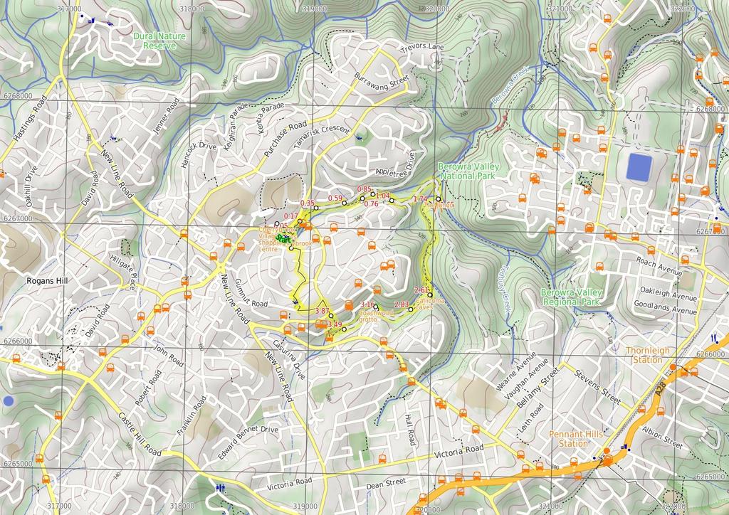
1 Callicoma Loop 2 hrs Hard track 5.1 km Circuit 153m This great circuit walk passes through some really nice forest around the fringe of Cherrybrook. Highlights of the walk include some beautiful rock overhangs at the 'Callicoma Caves', and the atmospheric 'Coachwood Grotto'. The walk starts and finishes at the pleasant Lakes of Cherrybrook park. 17m 98m Berowra Valley National Park Maps, text & images are copyright wildwalks.com Thanks to OSM, NASA and others for data used to generate some map layers.

2 Cherrybrook Village shopping centre Before You walk The Cherrybrook Village shopping centre is located at 1/7 Shepherds Drive, Cherrybrook. There are a number of local cafes and eateries here, plus some franchises such as Subway and Gloria Jeans, making a great stop for walkers. There is also a Woolworths supermarket. The centre is open 9:-5:3 Mon-Wed & Fri, 9:-9: Thu, 9:-5: Sat and 1:-: Sun. Some of the cafes and eateries open directly outside so they may be open longer hours. More info. Bushwalking is fun and a wonderful way to enjoy our natural places. Sometimes things go bad, with a bit of planning you can increase your chance of having an ejoyable and safer walk. Before setting off on your walk check The Lakes Of Cherrybrook The Lakes Of Cherrybrook is a park at the intersection of Shepherds Dr and Macquarie Dr, Cherrybrook. The lakes featured in the park were formed when the local creek was dammed for the benefit of farmers. The park has a free electric BBQ, sheltered picnic tables, taps and bubblers as well as a playground for the kids. There is a large shopping centre nearby. There are several signposted buswalks in the area, including the 5.1km 'Callicoma Walk' loop track. The Jungo The Jungo is a relatively small clearing and campsite near the junction of Berowra and ZigZag Creeks at a well signposted intersection. There is often water in the creeks (treat well before drinking) but there are no facilities. Speculation on the source of the name 'Jungo' includes the Aussie tendency to abbreviate words ('Junction' gets corrupted to 'jung-o' etc) as well as a possible derivation from one of a few similar sounding aboriginal words. Callicoma caves The Callicoma caves are a series of large sandstone overhangs on the Callicoma Walk near Cherrybrook. These beautiful sandstone overhangs are a highlight on the walks in the area. The sandstone has some beautiful texture and golden colouring. Coachwood grotto This beautiful, shady spot is beside Nyrippin creek, on the Callicoma Walk near Cherrybrook. The 'grotto' is an open area, shaded by Coachwood trees, with a curved section of low cliffs across the creek, giving an 'amphitheatre' feeling. This is a very atmospheric spot to sit and relax for a while. 1) Weather Forecast (BOM Metropolitan District) 2) Fire Dangers (Greater Sydney Region) 3) Park Alerts (Berowra Valley National Park) ) Research the walk to check your party has the skills, fitness and equipment required 5) Agree to stay as a group and not leave anyone to walk solo Think before you TREK The 'Think before you TREK' program developed by NSW Police & NPWS promotes the benefits of planning ahead for your bushwalking trip by using an easy to remember acronym: adequate supplies of food, water, navigation and first T Take aid equipment. your planned route and tell friends and family when R Register you expect to return. beacon (PLB's) should be carried on walks with E Emergency significant gaps in mobile coverage (check terrain profile). to your planned route and follow the map and walking K Keep trails. Topo Maps The maps provided on wildwalks are helpful, but there are times where you may need maps covering a broader area. Maps that cover this walk include; 1:25 Map Series:913S HORNSBY 1:1 Map Series:913 SYDNEY Grade This walk has been graded using the AS The overall grade of the walk is dertermined by the highest classification along the whole track. Grade /6 Hard track Length 5.1 km Circuit Time 2 hrs Quality of track Rough track, where fallen trees and other obstacles are likely (/6) Signs Directional signs along the way (3/6) Experience Required Some bushwalking experience recommended (3/6) Weather Storms may impact on navigation and safety (3/6) Infrastructure Limited facilities, not all cliffs are fenced (3/6)
3 Are you ready to have fun? Please ensure you and your group are well prepared and equipped for all possible hazards and delays. Check park closures, weather information and Fire Danger Rating before setting out. Optional side trips and alternate routes noted are not included in this walks overall grade, length or time estimate. Please allow extra time for resting and exploring areas of interest. The authors, staff and owners of wildwalks take care in preparing this information but will not accept responsibility for any inconvenience, loss or injury you may experience. Please take care, have fun - Happy Walking. Getting there You can get to Top of The Lakes Of Cherrybrook park (gps: , 151.2) by car or bus. Car: There is free parking available. This is a circuit, so you will finish back at the start. Find up to date and more information inlcuding; travel directions, weather, park closures and walker feedback at Cherrybrook Village shopping centre The Cherrybrook Village shopping centre is located at 1/7 Shepherds Drive, Cherrybrook. There are a number of local cafes and eateries here, plus some franchises such as Subway and Gloria Jeans, making a great stop for walkers. There is also a Woolworths supermarket. The centre is open 9:-5:3 Mon-Wed & Fri, 9:-9: Thu, 9:-5: Sat and 1:-: Sun. Some of the cafes and eateries open directly outside so they may be open longer hours. More info. Top of The Lakes Of Cherrybrook park (5 m 1 mins) From below 5 Shepherds Drive, opposite the shopping centre, the walk follows the concrete footpath into 'The Lakes Of Cherrybrook' park, keeping the playground to the right. The footpath comes to the signpost for 'Callicoma Walk' just before the unfenced lakes..5 The Lakes Of Cherrybrook The Lakes Of Cherrybrook is a park at the intersection of Shepherds Dr and Macquarie Dr, Cherrybrook. The lakes featured in the park were formed when the local creek was dammed for the benefit of farmers. The park has a free electric BBQ, sheltered picnic tables, taps and bubblers as well as a playground for the kids. There is a large shopping centre nearby. There are several signposted buswalks in the area, including the 5.1km 'Callicoma Walk' loop track..5 Lakes trackhead (12 m 2 mins) Veer left: From the 'Callicoma Walk' signpost, the walk follows the 'Sydney Cove' arrow along the concrete footpath, keeping the lakes on the right. The walk passes a free BBQ and picnic shelters on the left, and a couple of viewing platforms on the right before coming to an intersection just before the road and beside a low handmade stone wall..17 Int at stone wall (18 m 3 mins) Turn right: From behind the low stone wall, the track follows the concrete footpath down the hill through the graffiti-covered tunnel, emerging in a clearing behind the 'Cherrybrook Girl Guides' building. Veer right: From the clearing, the walk follows the bush track, initially keeping the Girl Guides hall on the left. The track passes a shortcut track on the right before coming to a 'T' intersection with a management trail marked with track arrows..35 Int. of Blackwattle Trail and Callicoma Walk (23 m mins) Veer right: From the intersection, the walk follows the management trail down the hill, keeping the houses to the left, arriving at the signposted intersection at the top of the stairs (with a track on the right)..59 Top of the Disturbed Creek stairs (17 m 3 mins) Veer right: From the intersection, the walk goes down the steps towards the creek. Immediately after crossing the creek, on concrete stepping stones, the walk bends to the left, following the 'Callicoma Walk' arrow. The walk soon crosses some old concrete slabs and then drops down some more steps. After following the creek, on the left, for a short distance the walk comes to an intersection (with a management trail coming down the hill on the right)..76 Int of Callicoma Walk and McKinley trail (1 m 2 mins) Veer left: From the intersection, the walk follows the management trail down the hill, keeping the creek on the left and soon arrives at a fork intersection..85 Int of Callicoma Walk and Disturbed Creek trail (18 m mins) Veer right: From the intersection, the walk follows the bush track, keeping the creek on the left and immediately passes a 'Callicoma Walk' signpost. The walk continues along the well formed bush track and climbs steeply to an intersection marked with a 'Callicoma Walk' and red GNW signpost. 1. Int of Callicoma Walk and Pogson Dr management tra (61 m 13 mins) Turn left: From the intersection, the walk follows the asphalted management trail up, over the hill, keeping the houses up to the right and soon arrives at an intersection marked with a 'Callicoma Walk' and red GNW track marker. Turn left: From the intersection, the walk follows the 'Callicoma Walk' arrow down the management trail (no asphalt), keeping the power lines to the left. The walk descends steeply for a while then flattens out and soon comes to an intersection with the Great North Walk. Continue straight: From the intersection, this walk follows the 'Great North Walk' sign along the wide trail as it bends left and leads downhill along the concrete section. The trail leads down across a usually small creek, then heads up to the well-signposted intersection beside the Jungo campsite, where a 'Fishponds' sign points back down along the trail The Jungo The Jungo is a relatively small clearing and campsite near the junction of Berowra and ZigZag Creeks at a well signposted intersection. There is often water in the creeks (treat well before drinking) but there are no facilities. Speculation on the source of the name 'Jungo' includes the Aussie tendency to abbreviate words ('Junction' gets corrupted to 'jung-o' etc) as well as a possible derivation from one of a few similar sounding aboriginal words The Jungo (9 m 2 mins) Turn right: From 'The Jungo', the walk follows the 'Callicoma Walk' arrow along the management trail which climbs steeply and soon comes to the intersection (with the management trail going up the hill to the left and the red Great North Walk marker pointing straight ahead). 1.7 Int of Stringybark Ridge Management Trail and GNW (88 m 18 mins) Continue straight: From the intersection, the walk follows the red Great North Walk marker along the bush track. The track undulates while following Berowra Creek (keeping the creek to the right) before crossing it on a metal foot bridge. The walk continues along the other side of the creek before crossing Nyrippin creek using concrete stepping stones. Immediately after the crossing, the walk arrives at the signposted intersection (with the 'Callicoma Walk' going to the right). Turn right: From the intersection, the walk follows the 'Callicoma Walk' arrow along the bush track keeping (not crossing) Nyrippin creek to the right. The track soon swings up the hill to the left, away from the creek. The walk soon climbs some stone cut steps to the intersection at the top of a rocky outcrop. Veer left: From the intersection, the walk follows the faint bush track, going steeply up the hill. The walk climbs up for a short distance, then arrives under a large overhang, marked with a number '6' sign Callicoma caves The Callicoma caves are a series of large sandstone overhangs on the Callicoma Walk near Cherrybrook. These beautiful sandstone overhangs are a highlight on the walks in the area. The sandstone has some beautiful texture and golden colouring Callicoma Caves (21 m 5 mins) Veer right: From the number '6' sign under the large overhang, the walk follows the bush track, around the rocks and base of the small cliffline (keeping them to the left). The walk passes under more large overhangs before dropping to an unmarked -way intersection Nyrippin Creek four ways (3 m 6 mins) Continue straight: From the intersection, the walk follows the bush track steeply down the steps towards the creek, where it bends to the left, onto an old management trail. The walk follows the management trail, keeping the creek on the right, before reaching a signposted intersection for the 'Callicoma Walk' Int Callicoma Walk and power line access trail (3 m ) Veer right: From the intersection, the walk follows the 'Callicoma Walk' arrow down the steps, towards the creek on the right. The track goes a short distance before reaching an intersection marked with an '8' sign Optional sidetrip to Coachwood grotto (2 m 1 mins) Turn right: From the intersection, the walk follows the steps steeply down the hill, soon coming to the viewing spot. At the end of this side trip, retrace your steps back to the main walk then Turn right Coachwood grotto This beautiful, shady spot is beside Nyrippin creek, on the Callicoma Walk near Cherrybrook. The 'grotto' is an open area, shaded by Coachwood trees, with a curved section of low cliffs across the creek, giving an 'amphitheatre' feeling. This is a very atmospheric spot to sit and relax for a while Number 8 sign (33 m 5 mins) Continue straight: From the intersection, the walk follows the management trail, keeping the creek on the right, passing several sewer inspection points, before reaching an intersection marked with an arrow marker (with steps going steeply down to the right). 3.9 Int of sewer management trail and Callicoma Walk (39 m 1 mins) Turn right: From the intersection, the walk follows the steps steeply down the hill before meandering along the creek, on the right, then crossing the creek on concrete stepping stones. The walk follows the bush track up the hill a short distance before turning right at a 'T' intersection with an old management trail (just behind a house). Soon after this, the walk comes to an intersection marked with 'Callicoma Walk' arrows. Turn left: From the intersection, the walk follows the 'Callicoma Walk' arrow steeply up the steps and soon arrives at Francis Greenway Drive Francis Greenway Dr trackhead (1.1 km 19 mins) Continue straight: From the 'Callicoma Walk' signposted track head at the end of Macquarie Dr (intersection with Francis Greenway Dr, Cherrybrook), the walk follows Macquarie Dr up the hill. The walk soon turns left into Gumnut Rd (look for the Callicoma Walk track marker on the corner) and continues to the intersection with Holly Rd (another track marker
.")
4 here). From here, the walk goes a short distance along Holly Rd and crosses to the 'Callicoma Walk Track marker near the small gate into 'Gumnut Playground'. Turn left: From the 'Callicoma Walk' track marker on Holly Rd, the walk goes through the gate and across 'Gumnut Playground' (there is a drinking bubbler near the fence). The walk goes out the gate on the opposite side and down a set of wooden steps to reach an arrow track marker beside Tallowwood Ave. Turn right: From the arrow track marker beside Gumnut Playground, the walk follows Tallowwood Ave gently down the hill, passing Sheoak Cl, then turning left into Ivy Pl (track marker at this intersection). Just before the end of Ivy Pl, the walk turns right and follows a concrete path between the houses (between 12 & 1 Ivy Pl). From the end of this path, the walk crosses Rossian Pl and continues along Glentrees Pl, then turns left into Kenburn Ave ('Callicoma Walk' track marker at this intersection). A short distance along Kenburn Ave, the walk arrives at the entrance to 'The Lakes Of Cherrybrook'..9 Kenburn Ave entrance to lakes park (21 m mins) Turn right: From 'The Lakes of Cherrybook' signpost on Tallowwood Ave, the walk follows the bush track into the park. The walk soon turns right at a junction with a 'Callicoma Walk' track marker, going down the steps and crossing a small bridge. The walk continues on the track as it skirts around the lake, to the left, dropping down a few steps and arriving at an intersection with an asphalted footpath and another bush track (There is a track marker just before the intersection). Continue straight: From the intersection, the walk follows the asphalted footpath across the bridge, towards the playground. After crossing the bridge, the footpath becomes concrete and bends to the right and soon reaches the large walking track signpost with 'Callicoma Walk' at the top. Turn left: From the 'Callicoma Walk' signpost intersection, the walk goes up the hill on the concrete footpath, keeping the playground on the left. At the top of the concrete footpath, the walk comes to Shepherds Drive, opposite the shopping centre and just below 5 Shepherds Drive.
5
6 Summary navigation sheet for the Callicoma Loop km From Start Top of The Lakes Of Cherrybrook park ,151.2 (GR Hornsby, 18867).5 Lakes trackhead ,151.7 (GR Hornsby, 18867).17 Int at stone wall , (GR Hornsby, ).35 Int. of Blackwattle Trail and Callicoma Walk ,151.7 (GR Hornsby, 19672).59 Top of the Disturbed Creek stairs , (GR Hornsby, ).76 Int of Callicoma Walk and McKinley trail , (GR Hornsby, 19672).85 Int of Callicoma Walk and Disturbed Creek trail , (GR Hornsby, ) 1. Int of Callicoma Walk and Pogson Dr management trail , (GR Hornsby, ) Powered by TCPDF ( The Jungo , (GR Hornsby, 2673) Int of Stringybark Ridge Management Trail and GNW , (GR Hornsby, 2672) Callicoma Caves , (GR Hornsby, 2665) Nyrippin Creek four ways , (GR Hornsby, ) Int Callicoma Walk and power line access trail , (GR Hornsby, ) Number 8 sign , (GR Hornsby, ) Number 8 sign , (GR Hornsby, ) Int of sewer management trail and Callicoma Walk , (GR Hornsby, ) Francis Greenway Dr trackhead , (GR Hornsby, ) Kenburn Ave entrance to lakes park ,151.8 (GR Hornsby, ) Up/Dwn Length Initial directions (Use full tracknotes and maps for more detail) m 1 mins 12 m 2 mins 18 m 3 mins 23 m mins 17 m 3 mins 1 m 2 mins 18 m mins 61 m 13 mins From below 5 Shepherds Drive, opposite the shopping centre, the walk follows the concrete footpath into 'The Lakes Of Cherrybrook' park, keeping the playground to the right. Veer left: From the 'Callicoma Walk' signpost, the walk follows the 'Sydney Cove' arrow along the concrete footpath, keeping the lakes on the right. Turn right: From behind the low stone wall, the track follows the concrete footpath down the hill through the graffiti-covered tunnel, emerging in a clearing behind the 'Cherrybrook Girl Guides' building. Veer right: From the intersection, the walk follows the management trail down the hill, keeping the houses to the left, arriving at the signposted intersection at the top of the stairs (with a track on the right). Veer right: From the intersection, the walk goes down the steps towards the creek m 2 mins 88 m 18 mins Turn right: From 'The Jungo', the walk follows the 'Callicoma Walk' arrow along the management trail which climbs steeply and soon comes to the intersection (with the management trail going up the hill to the left a... Continue straight: From the intersection, the walk follows the red Great North Walk marker along the bush track m 5 mins 3 m 6 mins 3 m Veer right: From the number '6' sign under the large overhang, the walk follows the bush track, around the rocks and base of the small cliffline (keeping them to the left). Continue straight: From the intersection, the walk follows the bush track steeply down the steps towards the creek, where it bends to the left, onto an old management trail. Veer right: From the intersection, the walk follows the 'Callicoma Walk' arrow down the steps, towards the creek on the right. Optional sidetrip to Coachwood grotto. Turn right: From the intersection, the walk follows the steps steeply down the hill, soon coming to the viewing spot. Continue straight: From the intersection, the walk follows the management trail, keeping the creek on the right, passing several sewer inspection points, before reaching an intersection marked with an arrow marker (... Turn right: From the intersection, the walk follows the steps steeply down the hill before meandering along the creek, on the right, then crossing the creek on concrete stepping stones. Continue straight: From the 'Callicoma Walk' signposted track head at the end of Macquarie Dr (intersection with Francis Greenway Dr, Cherrybrook), the walk follows Macquarie Dr up the hill. Turn right: From 'The Lakes of Cherrybook' signpost on Tallowwood Ave, the walk follows the bush track into the park. 2 m 1 mins 33 m 5 mins 39 m 1 mins 1.1 km 19 mins 21 m mins Veer left: From the intersection, the walk follows the management trail down the hill, keeping the creek on the left and soon arrives at a fork intersection. Veer right: From the intersection, the walk follows the bush track, keeping the creek on the left and immediately passes a 'Callicoma Walk' signpost. Turn left: From the intersection, the walk follows the asphalted management trail up, over the hill, keeping the houses up to the right and soon arrives at an intersection marked with a 'Callicoma Walk' and red GNW...
Hornsby Blue Gum Walk
 Hornsby Blue Gum Walk 3 hrs Hard track 6.7 km Circuit 4 374m This delightful loop is one of the prettiest and most popular walks in the Hornsby area. Going from an environment of ferns and clear bushland
Echo Point to Leura Forest via Three Sisters and Giant Stairs loop
 Echo Point to Leura Forest via Three Sisters and Giant Stairs loop 3 hrs 3.8 km Circuit Hard track 512m This walk starts from the popular Echo Point, in Katoomba, and winds down to the base of the Three
Wentworth Falls Conservation Hut Loop
 Wentworth Falls Conservation Hut Loop 3 hrs Hard track 6.7 km Circuit 4 341m This scenic walk from Wentworth Falls Station, winds along the Nature Trail to Conservation Hut, then drops into the magnificent
Hunters Hill to Epping Road
 Hunters Hill to Epping Road 2 hrs 30 mins 5.5 km One way Moderate track 154m An enjoyable walk through lower sections of the Lane Cove National Park, this walk features plenty of mangroves next to the
Carrington Park to Leura Forest and pass loop
 Carrington Park to Leura Forest and pass loop 3 hrs Hard track 4.8 km Circuit 4 674m This walk is a fantastic way to see Leura Forest. The walk descends from Carrington Park, visiting Leura Forest and
Epping to Pennant Hills Station (via Lane Cove River)
") Epping to Pennant Hills Station (via Lane Cove River) 3 hrs 5 mins 8.4 km One way Hard track 249m This walk, from Epping to Pennant Hills Station, is a great way to see the upper Lane Cove River Valley.
Epping to Pennant Hills Station (via Lane Cove River) 3 hrs 5 mins 8.4 km One way Hard track 249m This walk, from Epping to Pennant Hills Station, is a great way to see the upper Lane Cove River Valley.
Rail to River Walk. 3 hrs. Hard track 7.5 km Circuit. 222m
 Rail to River Walk 3 hrs Hard track 7.5 km Circuit 4 222m This walk is a great one from Chatswood Station to the Lane Cove River National Park. The walk descends through the vegetated bushland which fills
Katoomba Falls Circuit
 Katoomba Falls Circuit hr 5 mins.5 km Circuit Hard track 59m For those looking for a walk involving more than simple boardwalk, this trail winding through the temperate rain forest could be just the thing.
Popes Glen, Pulpit Rock, Govetts Leap and Braeside Walk
 Popes Glen, Pulpit Rock, Govetts Leap and Braeside Walk 8 hrs Hard track 13.6 km Circuit 4 1068m This large circuit walk, from Popes Glen to Pulpit Rock, Govetts leap and along the Braeside Track, passes
Heathcote to Engadine via Audley
 Heathcote to Engadine via Audley 6 hrs 3 mins 5 km One way Hard track 4 635m Covering a large section of central Royal National Park, this walk goes through the heath and scrub along a well managed and
Currie Rd to Davidson Park
 Currie Rd to Davidson Park 3 hrs 7.2 km One way Moderate track 28m Starting at Currie Rd in Forestville, this walk follows Middle Harbour to Davidson Park, under Roseville Bridge. There are two optional
Govetts Leap Loop. 1065m. 909m Blue Mountains National Park. 4 hrs 30 mins 8.7 km Circuit. Hard track 380m
 Govetts Leap Loop 4 hrs 30 mins 8.7 km Circuit Hard track 380m This walk, from Blackheath Train Station, is a fantastic way to see some of the iconic areas of the Blue Mountains in the Blackheath area.
Waterfall to Heathcote
 Waterfall to Heathcote 5 hrs Hard track 10.8 km One way 4 467m This walk explores the heart of Heathcote National Park, and is easily accessed with a train station at either end. Although relatively close
Little Digger Track. 68m. 1 Hr 2.2 km One way. Moderate track 93m. Moores Creek Reserve
 Little Digger Track Hr 2.2 km One way Moderate track 93m This walk follows Moores Creek through several reserves in east Roseville and East Lindfield. The track is named after Australia's 7th Prime Minster,
Morgans Creek to Padstow
 Morgans Creek to Padstow 2 hrs 45 mins 8 km One way Moderate track 3 144m This pleasant walk starts from the Morgans Creek park, at Henry Lawsons Drive, and follows the Georges River past the Boomerang
Wattamolla to Big Marley Beach
 Wattamolla to Big Marley Beach 4 hrs 10.4 km Circuit Moderate track 4m This walk is an excellent loop which takes in both the coast and the heathy inland of Royal National Park. Nearly the whole walk has
Sid Pulsford Walk. 175m. 33m. 1 hr 45 mins 4.1 km One way. Hard track 118m. Gosford LGA
 Sid Pulsford Walk 1 hr 5 mins.1 km One way Hard track 118m Sid Pulsford Walk explores the ridge top of Kincumber Mountain, from Honeman's Rock to Green Point. The walk mostly follows wide management trails.
Thornleigh to Hornsby
 Thornleigh to Hornsby 4 hrs Hard track 10.2 km One way 4 526m Starting at Thornleigh station you walk through suburban streets for a short while before diving into the bush at the southern end of Berowra
Little Digger Track to Davidson Reserve and Lyrebird Circuit
 Little Digger Track to Davidson Reserve and Lyrebird Circuit 4 hrs 3 mins 11.5 km One way Hard track 4 47m Exploring both the eastern and western sides of Middle Harbour Creek, this walk follows the Little
Wallarah Coastal Walk
 Wallarah Coastal Walk 3 hrs 8.3 km Return Hard track 247m This walk starts at Caves Beach and travels south along the coastline, until reaching the Pinney s Headland Lookout. There are many opportunities
The Foreshore Walk. 24m. 1m Lake Macquarie LGA. 1 hr 15 mins 2.9 km One way. Hard track 81m
 The Foreshore Walk 1 hr 15 mins 2.9 km One way Hard track 81m This walk traverses the coastline of the Green Point reserve. By following a variety of tracks and occasionally traveling inland through eucalyptus
Dead Horse Gap Loop track
 Dead Horse Gap Loop track 4 hrs 30 mins Hard track 9.8 km Circuit 144m 4 This walk starts with a ride up the Kosciuszko Express Chairlift. There is an opportunity to eat at Australia's highest restaurant,
Epping to Eastwood Station (via Lane Cove River)
") Epping to Eastwood Station (via Lane Cove River) hrs 45 mins 10.2 km One way Moderate track 189m Epping to Eastwood, via Lane Cove River, is the longer route through the bush between the stations. This
Epping to Eastwood Station (via Lane Cove River) hrs 45 mins 10.2 km One way Moderate track 189m Epping to Eastwood, via Lane Cove River, is the longer route through the bush between the stations. This
Rail to River and Stringybark Creek Reserve Walk
 Rail to River and Stringybark Creek Reserve Walk 4 hrs Hard track 11.2 km Circuit 4 302m This walk begins in the busy city of Chatswood and soon enters the nearby bushland around the Lane Cove River. The
Campbell Drive to Snapper Point
 Campbell Drive to Snapper Point 1 hr 45 mins 4.2 km One way Experienced only 135m This walk follows the Coast Track to Frazer Beach, along the Geebung and (overgrown) Grass Tree Tracks. From the northern
Mackerel Beach, West Head Loop
 Mackerel Beach, West Head Loop 5 hrs 8.6 km Circuit Hard track 422m The Mackerel Beach, West Head Loop is a walk which explores a large part of the West Head. The journey starts and finishes with a ferry
Teralba to Charlestown Park track head
 Teralba to Charlestown Park track head 4 hrs 30 mins 13.3 km One way Moderate track 3 220m This section of the Great North Walk starts from the Teralba train station and winds down and around the edge
De Burgs Bridge to Thornleigh station
 De Burgs Bridge to Thornleigh station 3 hrs 45 mins 9.7 km One way Hard track 4 363m This walk follows a section of the Great North Walk, starting from De Burghs bridge. The walk winds north west, through
The Basin Track and Mackerel Track
 The Basin Track and Mackerel Track 3 hrs 5.9 km Circuit Hard track 226m This walk is a great way to see some popular areas in Ku-ring-gai Chase National Park. The walk from West Head Rd travels to The
Middle Harbour Creek Loop
 Middle Harbour Creek Loop 5 hrs 45 mins 15.1 km Circuit Experienced only 5 570m This walk explores the upper reaches of Middle Harbour Creek, starting and ending at the great parklands at Davidson Park,
Upper Rumbalara circuit
 Upper Rumbalara circuit 1 hr 30 mins 3.3 km Circuit Hard track 176m A great circuit walk, covering most of the walking tracks and sights in the upper section of the Rumbalara Reserve. There is some really
Sphinx, Warrimoo and Bobbin Head tracks
 Sphinx, Warrimoo and Bobbin Head tracks 4 hrs 9.6 km Circuit Moderate track 499m This great walk starts at the Sphinx Memorial and loops around via Cowan Creek, exploring diverse environments as it changes
Mackerel Beach and Resolute Loop
 Mackerel Beach and Resolute Loop 3 hrs 5.4 km Circuit Hard track 384m This walk is another great walk in Ku-ring-gai Chase National Park, accessed by ferry. From the Mackerel Beach wharf, this walk uses
Balmoral Beach to The Spit
 Balmoral Beach to The Spit 2 hrs 30 mins.3 km One way Hard track 85m This walks follows the coast from Balmoral to the Spit and across Spit Bridge. There are some alternate tracks to consider at high-tides,
De Burghs Bridge to Fullers Bridge
 De Burghs Bridge to Fullers Bridge 2 hrs 3 mins Hard track 6 km One way 2m 4 Following the Lane Cove River, this walk mostly follows a section of the Great North Walk and is well maintained and signposted.
Scenic World to Echo Point
 Scenic World to Echo Point 1 hr 15 mins 2.1 km One way Moderate track 192m This is one of the most popular tourist walks in the Katoomba area. The walk follows the cliffs along a well maintained and signposted
National Pass from Wentworth Falls to Conservation Hut
 National Pass from Wentworth Falls to Conservation Hut 3 hrs Hard track 3.6 km One way 739m Starting at Wentworth Falls picnic area, this scenic and historic walk explores many waterfalls, lookouts and
Berowra to Mt Kuring-gai
 Berowra to Mt Kuring-gai 4 hrs 30 mins 9.4 km One way Hard track 4 551m From the ridges above Cowan Creek, this walk takes in some great lookouts (especially around Mt Kuringgai) as well as enjoying an
Woolwich Wharf to Boronia Park
 Woolwich Wharf to Boronia Park 2 hrs 5.8 km One way Moderate track 175m Going through the streets of Hunters Hill, this walk is on the first segment of the Great North Walk. The majority of the walk is
Under and Over Cliff Walk
 Under and Over Cliff Walk 4 hrs 9.4 km Circuit Moderate track 576m This walk from Wentworth Falls Station is a fantastic way to see a large majority of the Wentworth Falls cliffline. The track winds under
Green Point Circuit Walk
 Green Point Circuit Walk 3 hrs 7.7 km Circuit Hard track 269m This walk visits all of the popular locations in Green Point Reserve, as well as some of the lesser-visited areas inland. Taking in Sea Eagle
Blackheath Station to Junction Rock Loop (via Grand Canyon and Popes
 Blackheath Station to Junction Rock Loop (via Grand Canyon and Popes 8 hrs 30 mins 18.2 km Circuit Hard track 4 1254m This circuit starts in Blackheath and heads down into the Grand Canyon and Rodriguez
Spit Bridge to Middle Head Forts
 Spit Bridge to Middle Head Forts 2 hrs 30 mins 6.3 km One way Hard track 4 181m This scenic walk takes you from the Spit Bridge, along the coast to explore the Middle Head Forts. There are a few alternate
Patonga to Woy Woy. 5 hrs 45 mins 15.5 km One way. Hard track. 497m
 Patonga to Woy Woy 5 hrs 45 mins 15.5 km One way Hard track 4 497m This walk explores a variety of environments from the shore line and coastal cliffs near Patonga, to the dry, rocky and open ridge line.
Bouddi Coastal Walk. 5 hrs. Hard track 8.1 km One way. 364m
 Bouddi Coastal Walk 5 hrs Hard track 8.1 km One way 4 364m This is one of the longer walks in the Bouddi National Park and it is rich in scenery. The walk follows the coastline with many side trips to
Wentworth Falls Station Loop (Undercliff Walk)
") Wentworth Falls Station Loop (Undercliff Walk) 4 hrs 3 mins Hard track 8.9 km Circuit 658m 4 This walk passes some stunning waterfalls and views into the Jamison Valley, following the cliff edges around
Wentworth Falls Station Loop (Undercliff Walk) 4 hrs 3 mins Hard track 8.9 km Circuit 658m 4 This walk passes some stunning waterfalls and views into the Jamison Valley, following the cliff edges around
Epping to Gordon Station
 Epping to Gordon Station 4 hrs 15 mins 11.7 km One way Hard track 4 365m This walk, from Epping Station to Gordon Station, passes below the homes which sit on the hills high above the Lane Cove River.
Gordon to Chatswood Station
 Gordon to Chatswood Station 4 hrs 30 mins 12.2 km One way Hard track 4 381m This walk is a great way to get into the bush without being far from civilisation. The walk wanders through untouched valleys
Dubbo Gully and Ten Mile Hollow Circuit (via Clares Bridge)
") Dubbo Gully and Ten Mile Hollow Circuit (via Clares Bridge) 2 Days Hard track 24.3 km Circuit 4 1117m This two day (or ten hour) walk follows several historic roads, now closed to traffic. Starting with
Dubbo Gully and Ten Mile Hollow Circuit (via Clares Bridge) 2 Days Hard track 24.3 km Circuit 4 1117m This two day (or ten hour) walk follows several historic roads, now closed to traffic. Starting with
Federal Pass Walking Track
 Federal Pass Walking Track 5 hrs Hard track 8 km One way 4 989m This classic trail follows along the base of the cliffs from Leura to the Golden Stairs, passing many of the more popular sights of the Katoomba
Echo Point to Leura Forest Circuit
 Echo Point to Leura Forest Circuit 3 hrs 4.8 km Circuit Hard track 588m Forming a circuit around the cliffs and then the valley floor, this is a walk more then capable of convincing a walker of the beauty
Taronga Wharf to Chowder Bay
 Taronga Wharf to Chowder Bay 2 hrs 4.4 km One way Moderate track 246m Starting at Taronga Wharf, this walk passes many icons of Sydney, including Taronga Zoo, HMAS Sydney Mast, Chowder Bay. The walk also
Roseville to Macquarie Park
 Roseville to Macquarie Park 3 hrs 3 mins 8.8 km One way Hard track 4 29m This walk starts at Roseville station and explores the streets and alleyways of Roseville before joining the main spine of the Great
Sphinx to Mt Kuring-gai
 Sphinx to Mt Kuring-gai 4 hrs 45 mins 1.7 km One way Hard track 673m This walk starts at the Sphinx War Memorial and follows some well maintained and popular walking tracks down to Cowan Creek. Enjoy the
Glenbrook and Euroka Circuit
 Glenbrook and Euroka Circuit 2 Days 16.6 km Circuit Experienced only 790m This two day circuit, returning to Glenbrook Station, is a scenic walk which passes many of the tourist attractions within the
Rumbalara Explorer. 158m. 5m Rumbalara Reserve. 2 hrs 45 mins 6.1 km Circuit. Hard track 326m
 Rumbalara Explorer 2 hrs 5 mins 6.1 km Circuit Hard track 326m Pretty well the grand tour of the Rumbalara Reserve, this walk takes in much of the great scenery the reserve has to offer. The walk covers
Wentworth Falls Station Loop
 Wentworth Falls Station Loop 5 hrs 3 mins 9.5 km Circuit Hard track 4 13m The Wentworth Falls Station Loop takes in most of the upper tracks around Wentworth Falls. There are many scenic views near the
Lane Cove Tourist Park River Circuit
 Lane Cove Tourist Park River Circuit 5 hrs 12 km Circuit Hard track 383m This walk follows a large section of Lane Cove River. The walk follows the Riverside Walking track up the Lane Cove River to De
Wentworth Falls Loop. 893m. 665m. 6 hrs 10.2 km Circuit. Hard track 1093m. Blue Mountains National Park
 Wentworth Falls Loop 6 hrs 1.2 km Circuit Hard track 193m This is a great walk, both in size and spectacular views. The walk makes its way from Wentworth Falls train station and drops off the plateau,
Gosford to Lisarow. 202m
 Gosford to Lisarow 4 hrs 3 mins Hard track 11.3 km One way 4 479m This walk is a great way to explore the ridge-top bushland between Gosford and Lisarow. Passing through Rumbalara and Katandra Reserves,
North Ryde Fairyland circuit
 North Ryde Fairyland circuit 2 hrs 30 mins Hard track 6.9 km Circuit 193m 4 Starting at North Ryde train station this walk explores a stretch of the Lane Cove River, visiting the historic Fairlylands Pleasure
Hermitage Foreshore Track
 Hermitage Foreshore Track 1 Hr 2.2 km One way Moderate track 123m The Hermitage Foreshore Walk is a wonderful way to explore Sydney Harbour from the perspective of South Head. This walk starts from Nielsen
Bobbin Head Loop. 166m. 0m Ku-ring-gai Chase National Park. 5 hrs 12.9 km Circuit. Hard track 619m
 Bobbin Head Loop 5 hrs 12.9 km Circuit Hard track 619m This great circuit walk enjoys a variety of landscapes in Ku-ring-gai Chase National Park. The walk starts at the historic Sphinx war memorial and
Faulconbridge to Blaxland
 Faulconbridge to Blaxland 2 Days Experienced only 15.2 km One way 5 693m This two-day walk, or very solid one-day walk, takes you from station to station, through lush, scenic forest in the lower Blue
Charlestown Park trackhead to Newcastle station
 Charlestown Park trackhead to Newcastle station 5 hrs 30 mins 12.1 km One way Hard track 4 287m This section of the Great North Walk starts from the Charleston Park track head and winds through the streets
Scenic world to Three Sisters Loop via Furber Steps
 Scenic world to Three Sisters Loop via Furber Steps 5 hrs 5.8 km Circuit Hard track 722m This walk starts from the popular Scenic World, in Katoomba, and winds down the Furber steps into the Jamison Valley,
The Coast Track. 2 Days. Hard track 27.4 km One way. 1351m
 The Coast Track 2 Days Hard track 27.4 km One way 4 1351m Heading south, this walk covers the coastline of the Royal National Park and can truly only be described as amazing. With breathtaking coastal
Spit Bridge to Manly (Manly Scenic Walkway)
") Spit Bridge to Manly (Manly Scenic Walkway) 3 hrs 45 mins 9.1 km One way Moderate track 349m The Spit to Manly walk is a classic bushwalk on Sydney's Northern Beaches. The walk follows a well-maintained
Spit Bridge to Manly (Manly Scenic Walkway) 3 hrs 45 mins 9.1 km One way Moderate track 349m The Spit to Manly walk is a classic bushwalk on Sydney's Northern Beaches. The walk follows a well-maintained
Chatswood to Epping Station
 Chatswood to Epping Station 6 hrs Hard track 16.3 km One way 4 533m This walk, from Chatswood to Epping, is a long but enjoyable walk along the Lane Cove valley. The walk mostly follows the Lane Cove River
Cape Banks Circuit. 50m. 2m Botany Bay National Park. 3 hrs 7.3 km Circuit. Hard track 190m
 Cape Banks Circuit 3 hrs 7.3 km Circuit Hard track 19m This Cape Banks Circuit has a lot to offer and is thoroughly recommended. The walking travels over beaches, through coastal forest and across exposed
Bouddi Ridge and Coastal Walk
 Bouddi Ridge and Coastal Walk 2 Days Hard track 27 km Circuit 4 126m This overnight walk takes in the majority of the magnificent Bouddi National Park. The walk starts from the pleasant Putty Beach camping
Manly to Seaforth Oval
 Manly to Seaforth Oval 5 hrs 45 mins 13.7 km One way Moderate track 3 624m This walk follows the Manly to Spit Scenic Walkway, then continues past The Spit Bridge to Seaforth Oval. The walk provides magnificent
Narrabeen Lagoon Trail (from Middle Creek)
") Narrabeen Lagoon Trail (from Middle Creek) 2 hrs 30 mins 8.6 km Circuit Very easy 1 105m The Narrabeen Lagoon Trail is a wonderful and accessible walk on the Northern Beaches of Sydney. The trail is used
Narrabeen Lagoon Trail (from Middle Creek) 2 hrs 30 mins 8.6 km Circuit Very easy 1 105m The Narrabeen Lagoon Trail is a wonderful and accessible walk on the Northern Beaches of Sydney. The trail is used
Taronga Zoo to Spit Bridge
 Taronga Zoo to Spit Bridge 5 hrs Hard track 1.4 km One way 4 41m This is a scenic and culturally rich walk with views over Sydney Harbour and many interesting heritage buildings along the way. The start
Sydney to Thornleigh via Lane Cove Tourist Park
 Sydney to Thornleigh via Lane Cove Tourist Park 2 Days 33 km One way Hard track 4 1114m This overnight walk starts from the Obelisk in Macquarie Park, Sydney, at the official start of the Great North Walk.
Light to Light Walk 2 days
 Light to Light Walk 2 days 2 Days Hard track 3.9 km One way 4 794m Over two days, this classic walk explores the coast from Boyd Tower to the Green Cape Lighthouse in the south. Hegartys Bay Camp is over
Six Foot Track. 1212m
 Six Foot Track 3 Days 44.8 km One way Hard track 4 2066m This classic walk takes you from Katoomba to Jenolan Caves via a historic horse route. The walk travels mainly along well-maintained service tracks
Loch Ness Shores Club Site
 Loch Ness Shores Club Site Camping and Caravanning Falls of Foyers Route Summary A strenuous walk from Loch Ness Shores Club Site. The route climbs through forest to The Upper Foyers Waterfall and then
The Mendip Way. Route Directions and Maps Wells to Frome
 The Mendip Way Route Directions and Maps Wells to Frome Website: www.mendiphillsaonb.org.uk Email: mendip@mendiphillsaonb.org.uk Facebook & Twitter: @MendipHillsAONB Phone: 01761462338 1 Wells to Shepton
Winterfold Wood. point your feet on a new path. In Brief
 point your feet on a new path Winterfold Wood Distance: 8½ km=5¼ miles Region: Surrey Author: Schwebefuss Refreshments: Windmill Inn, Peaslake after the walk moderate walking with many gradients Date written:
LDWA SOUTH DOWNS MARATHON 13 th MAY 2018
 AHD ahead SDW South Downs Way BL/BR bear left/bear right TL/TR turn left/turn right X cross LEG 1 - EAST DEAN to WP1 NORTON GR 470019. Open 1030 to 1300. 9.7 miles. 1.1 From village hall TL and walk to
Danbury Words and pictures by Laurie Page of the Public Rights of Way team at Essex County Council.
 Danbury Words and pictures by Laurie Page of the Public Rights of Way team at Essex County Council. An undulating walk from Danbury village to the bluebells at the National Trust property of Blakes Wood.
Tideswell to Castleton
 Tideswell to Castleton 1 Walk summary Length: 14 km, 8.5 miles Maps: OS Explorer OL1 The Peak District - Dark Peak Area, OS Explorer OL24 The Peak District - White Peak Area, OS Landranger 110 Sheffield
ST. AGNES. you cannot put a time limit on beauty.
 ST. AGNES CIRCULAR WALKS AROUND There are many enjoyable and picturesque walks around St. Agnes most are signposted and are featured on the St. Agnes Mini-guide map. Because most of our footpaths are in
Hammer Vale and Linchmere Common
 point your feet on a new path Hammer Vale and Linchmere Common Distance: 9 km=5½ miles or 6 km=3¾ miles easy walking with one steep section Region: Hampshire, West Sussex Author: Botafuego Refreshments:
Harbour Bridge to Taronga Zoo
 Harbour Bridge to Taronga Zoo 4 hrs 9.8 km One way Moderate track 389m On this walk, you will explore much of the foreshore linking Milsons Point Station to Taronga Zoo Ferry wharf. The walk is mostly
RILLINGTON TO MALTON by Tania Dickinson
 RILLINGTON TO MALTON by Tania Dickinson This walk takes you from the Vale of Pickering up on to the Wold scarp, before dropping down again through the pretty village of Settrington and joining the Centenary
ULTRA-TRAIL AUSTRALIA May 2018 COURSE DESCRIPTION AND COURSE NOTES
 ULTRA-TRAIL AUSTRALIA 100 19-20 May 2018 COURSE DESCRIPTION AND COURSE NOTES LEG 1 Scenic World (Start) to Narrow Neck (Checkpoint 1) Course Description: From the start, at the front entrance of Scenic
Bakewell Club Site - Robin Hood's Stride
 Bakewell Club Site - Robin Hood's Stride Camping and Caravanning Route Summary A circular walk with fabulous views winding it's way through the beautiful White Peak scenery. Points of interest include
Rhossili - Tears Point - Mewslade Bay - Talgarth's Well - Rhossili - ID: 148. Walk description:
 Walk description: A glorious walk combining thrilling cliffs with beautiful wild beaches and a bird's-eye view of the Gower peninsula from Rhossili Down. The adventurous can walk out to the Worm's Head
Detailed Descriptions and Maps of Woodside s Nature Trails
 Detailed Descriptions and Maps of Woodside s Nature Trails Access Mill Road Trail Park along Anderson Mill road. Signs on West Pleasant Colony and Anderson Mill road clearly point to the beginning of the
Route: Skewsby Foulrice Stearsby
 Route: Skewsby Foulrice Stearsby Distance: 7 miles Map: Explorer: 300 Howardian Hills & Malton Start (OS ref): SE625710 Park in the village of Skewsby. Walk east out of the village to the T-Junction and
Beautiful Walks from the Blue Ball Inn
 Walk No. 7 COAST AND VALLEY WALK Countisbury, Glenthorne, County Gate, Brendon, Rockford and Wilsham 10 MILES APPROX. Walking time 5 hours approx. (not including breaks)> OS Sheet 64/74 Lynton and Lynmouth.
Hexham Abbey to the Racecourse Road
 Hexham Abbey to the Racecourse Road The Yarridge Road, or Racecourse Road as it is often known, runs along the ridge line to the south of Hexham and provides wonderful views of the river valley and fells
THE WELLDIGGERS ARMS, HESWORTH AND FITTLEWORTH TRAIL
 THE WELLDIGGERS ARMS, HESWORTH AND FITTLEWORTH TRAIL 5.5 miles Circular 3 hours 041017 Challenging Terrain A 300-year-old pub turned country-inn on the edge of the South Downs National Park, The Welldiggers
LDWA SOUTH DOWNS MARATHON
 AHD ahead SDW South Downs Way BL/BR bear left/bear right TL/TR turn left/turn right SP signpost/fingerpost X cross LEG 1 - EAST DEAN to WP1 NORTON GR 470019. Open 1030 to 1300. 9.6 miles. 1.1 From village
NEWLANDS CORNER AND ST MARTHAS
 NEWLANDS CORNER AND ST MARTHAS 10k CIRCULAR ROUTE 2½-3HRS GU4 8SE From Newlands Corner on the North Downs just outside Guildford, you can enjoy one of the most beautiful panoramas of quintessential English
Distance: 5 km=3 miles or 4½ km=2¾ miles or 3½ km=2 miles
 point your feet on a new path Vann Lake Distance: 5 km=3 miles or 4½ km=2¾ miles or 3½ km=2 miles Region: Surrey Author: Schwebefuss Refreshments: Ockley easy walking Date written: 12-feb-2011 Date revised:
Distance: 14 km=8½ miles or 7 km=4½ miles easy-to-moderate walking
 point your feet on a new path Normandy Distance: 14 km=8½ miles or 7 km=4½ miles easy-to-moderate walking Region: Surrey Author: Botafuego Refreshments: Pirbright, Ash date written: 20-feb-2012 date revised:
Harlington - Sharpenhoe - Pulloxhill
 Harlington - Sharpenhoe - Pulloxhill ID: 3676, Distance: 8 miles, Height gain: 140 Metres, Map: Explorer 193 Luton & Stevenage, Contributor: Dennis Jeanes Duration: 3 Hours 27 Mins Features Church,Great