GLEN EIRA CITY COUNCIL. MURRUMBEENA Transforming our neighbourhood together our concepts based on your ideas
|
|
|
- Michael Cook
- 5 years ago
- Views:
Transcription


1 GLEN EIRA CITY COUNCIL MURRUMBEENA Transforming our neighbourhood together our concepts based on your ideas 1

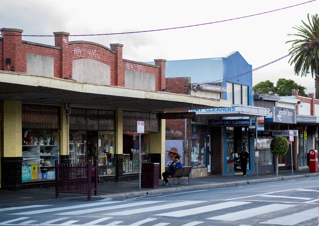
2 WHAT HAVE WE HEARD? WHAT NOW? Stage one Tell us what you love about your shopping strip November 2016 February 2017 From November 2016 to February 2017 we asked What do you love about your shopping strip? More than 2,100 surveys were completed across Glen Eira s 17 activity centres. A total of 135 surveys were completed for the Murrumbeena shopping strip. Based on this feedback, a report has been developed to identify key issues for each of Glen Eira s 17 activity centres. This has been used to draft key objectives and a draft vision for each centre. Each of the centres had unique differences however there were a number of themes which were consistent across all: 2 Creating places for people Respondents wanted vibrant community spaces, community hubs and places for people to gather. More greenery and amenity There was a desire for more greenery, open space and amenities such as seating, shade and bins. Night-time activity Respondents called for an increase in night-time activity with extended trading hours of cafes, restaurants and bars. Changing ways of moving around While parking was a common issue, respondents called for improved walking, cycling and public transport access and the infrastructure to support this. Appropriate development There was mixed support for new residential development some strongly opposed, others supported so long as height limits are controlled and buildings fit in with local character. Glen Eira City Council undertakes community engagement in order to inform, consult and involve the community. This ensures that decision-making is transparent, represents the views of the community, and is inclusive of diverse perspectives. The full consultation report can be viewed at Stage two Transforming our neighbourhood together our concepts based on your ideas March April 2017 This document presents a draft vision, key objectives and three concept ideas, which were developed based on the feedback received from the first stage of consultation. Council is now seeking community input and feedback to test these concepts and ensure they match with the community s vision and expectations. At this stage, these concepts are only ideas. The adopted concepts will require further detailed development and would be considered as part of Council s long-term planning and delivered over time. Where appropriate, projects will be presented as recommendations to the Level Crossing Removal Authority for inclusion in their upgrade works. Murrumbeena into the future Murrumbeena is considered a quiet and friendly suburb. Many respondents were concerned about the impact of skyrail and noted the importance of replanting the vegetation removed due to the train station upgrades. Small businesses and the local nature of the strip were highly valued however there was concern over many going out of business. Participants highlighted a lack of medical facilities in the area. Draft vision Murrumbeena will be a thriving local centre with a strong community focus. Draft key objectives > > Ensure adequate bicycle infrastructure and parking. > > Create more safe and green open spaces which are functional, easily maintained and cater for all parts of the community. > > Maintain and rejuvenate old building facades/ shopfronts. > > Support small local businesses including orgainising activities to bring business to the centre. > > Create community hubs where local groups can meet. > > Enforce height limits and building design that maintains local character. To provide feedback or receive updates throughout the consultation process, visit Consultation stages Stage one Tell us what you love about your shopping strip. November 2016 February 2017 Stage two Transforming our neighbourhood together our concepts based on your ideas. March April 2017 Stage three We will seek community feedback on building and development guidelines across all commercial areas with a more detailed focus on Bentleigh, Carnegie and Elsternwick. June July 2017 Stage four We will seek feedback on draft structure plans for Bentleigh, Carnegie and Elsternwick, which will incorporate the previous three themes of vision, key projects and built form. June July 2017 Stage five We will ask for community feedback on the final structure plans before they are presented to Council. October November
3 SUMMARY OF CONCEPTS Create a new village green in the heart of Murrumbeena Create new green spaces that support a wide range of public uses and encourage social interaction, on the southern side of, east of the station entry. Transition to a pedestrian-friendly centre Investigate opportunities to pedestrianise to improve safety, and create spaces for social and casual recreation. Strengthen Murrumbeena s village character Retain and strengthen the physical village scale of the Murrumbeena shopping strip. Create an integrated network of green spaces Create an integrated network of green spaces that cater for casual recreation and connect to existing parks and cycle paths. Beena Avenue Oakdene Crescent MURRUMBEENA ROAD Melbourne Street Omama Road Hobart Road Tuckett Street Emily Street Dunoon Street Ardyne Street Reserve m 4 5


4 EXISTING CREATE A NEW VILLAGE GREEN IN THE HEART OF MURRUMBEENA The Murrumbeena community has identified a lack of green public spaces that provide opportunities for community gatherings. This concept seeks to address this issue by creating a new green space within the centre and reinventing the existing community plaza. These spaces seek to become the new heart of the activity centre and would accommodate a range of uses both during the day and into the night. This concept could include: > > the creation of a new green space adjacent to the train station entry; and > > increased street greenery and public spaces, which encourage social interaction. CONCEPT EXAMPLE WHAT IT COULD LOOK LIKE Community benefits > > Increased opportunities for walking and cycling. > > Attracting new visitors to the centre. > > Providing the centre with an enhanced sense of place or identity. > > A high quality useable community space within the centre. > > Potential for night events and activities. > > The State Government is the key land owner within the precinct. > > The new plaza space may compete with other proposals within the centre we would need to determine the amount of open space required within the activity centre. > > Unknown impact on station parking. Next steps > > Investigate opportunities for works above the rail corridor in Murrumbeena in partnership with the Level Crossing Removal Authority. If the community supported this concept, it could involve the following: > > creating a new village green in the heart of Murrumbeena that supports a wide range of public uses and encourages social interaction, on the southern side of, east of the train station entry. EXAMPLE PRAHRAN 7


5 EXISTING TRANSITION NEERIM ROAD TO A PEDESTRIAN-FRIENDLY CENTRE is currently a local shopping street with limited opportunities to walk, shop and play within the centre. Reducing traffic on and creating a new pedestrian-friendly centre will ensure all visitors and residents feel safe and welcomed when walking through the activity centre. This concept could include: > > reducing vehicle traffic on by investigating opportunities to close or reallocate road space to pedestrians, between Murrumbeena Road and Hobart Street; > > investigating the opportunities and constraints of the Level Crossing Removal Authority constructing a new link road between Hobart and Ardyne Streets; > > greater pedestrian connections along to encourage new visitors and increase the amount of time they spend within the activity centre; > > unlocking opportunities to increase street activation and encourage the types of uses that make the shopping precinct successful; > > the addition of street trees, lighting and extended footpaths, which will create a safer and more enjoyable experience for residents and visitors to the street; > > the upgrade of pedestrian crossing points; and > > pedestrianising appropriate sections of local streets, making them quieter and more enjoyable for residents. CONCEPT EXAMPLE WHAT IT COULD LOOK LIKE, Murrumbeena Community benefits > > Increased visitation to local business. > > Safer streets. > > Increased opportunities for walking and cycling. > > Street activation. > > Decreased road traffic speeds. > > Free-up road space for other uses. > > The reconfiguration of the road network would require comprehensive traffic analysis. > > Changes to travel behavior. > > Koornang Road is managed by VicRoads Council is required to seek approval and funding for any changes to the street. > > Unknown impact on street car parking. Next steps > > Seek community support to transition into a safer, pedestrian-friendly environment. > > Investigate partnership opportunities with the Level Crossing Removal Authority to deliver place-based outcomes for the centre. If the community supported this concept, it could involve the following: EXAMPLES PRAHRAN/WINDSOR > > Transition to a pedestrian-friendly area between Murrumbeena Road and Hobart Street by diverting car routes, improving pedestrian accessibility and creating spaces for social and casual recreation, by exploring the following options for : > > Pedestrian shared zone two-way with selected footpath extensions. > > One-way westbound with extended footpath. > > One-way eastbound with extended footpath. > > Pedestrianisation of street and full closure to vehicle traffic. For further discussion and options regarding the treatments, see next pages. Manage traffic impact on Ardyne and Dunoon Streets by exploring the following options: > > Restrict southbound movement with signalised intersection at Ardyne Street and the new link road. > > Restrict access from the proposed new link road to Ardyne Street through constructing a raised median island and banning northbound movements from Ardyne Street. > > Restrict southbound movement by closing southbound entry to Ardyne and Dunoon Streets. > > Close vehicular entry from Railway Parade to Ardyne and Dunoon Streets. Manage traffic impact on Hobart Road by exploring the following options: > > Install roundabout with raised pedestrian crossings and with a mid-block closure along Hobart Road. > > Install roundabout with raised pedestrian crossings and restricted access to Hobart Road. > > Install roundabout with raised pedestrian crossing on all approaches. For further discussion and options regarding managing traffic impacts of the proposed new link road, see pages 12 and 13. 9
6 NEERIM ROAD OPTIONS BEING CONSIDERED ONE-WAY CONVERSION EASTBOUND ONE-WAY CONVERSION WESTBOUND TWO-WAY SHARED ZONE FULL CLOSURE enue By extending footpaths and reducing traffic lanes within, a one-way treatment could be implemented to create a safer and more accessible street. Analysis shows in this section of there is capacity for vehicles to take alternative paths without having significant impact on the existing road network. By maintaining an eastbound movement, Neerim Road is still accessible from Murrumbeena Road. > > Reduction in car traffic. > > Extended footpaths and a safer pedestrian environment. > > Increased retail and hospitality opportunities. > > Creation of plaza space at Murrumbeena Road. > > The reconfiguration of the road network would require comprehensive traffic analysis. > > Ensuring adequate access to businesses and train station is maintained. Oakdene Crescent MURRUMBEENA ROAD Melbourne Street By extending footpaths and reducing traffic lanes within, a one-way treatment could be implemented to create a safer and more accessible street. Analysis shows in this section of there is capacity for vehicles to take alternative paths without having significant impact on the existing road network. However, by maintaining only westbound movements, would no longer be accessible from Murrumbeena Road. > > Reduction in car traffic. > > Extended footpaths and a safer pedestrian environment. > > Increased retail and hospitality opportunities. > > Creation of plaza space at Murrumbeena Road. > > Increased traffic flow on Murrumbeena Road. > > The reconfiguration of the road network would require comprehensive traffic analysis. > > Ensuring that adequate access to businesses and the train station is maintained. > > Loss of access from Murrumbeena Road. A two-way shared zone treatment can be implemented for the full commercial length of. A shared zone is a road or network of roads where pedestrians, cyclists and vehicles share the roadway. Typically a shared zone has a sign-posted speed limit of 10km/ph and is implemented in locations where pedestrians are expected to outnumber vehicles. Alternate surface materials are often used to make them appear more like pedestrian spaces and distinguish the spaces from roads. > > Reduction in car traffic. > > Maintains two traffic flows. > > Safer pedestrian environment. > > Increased retail and hospitality opportunities. > > The reconfiguration of the road network would require comprehensive traffic analysis. > > VicRoads approvals would be required for shared zone implementation. The closure of would provide a full pedestrian mall and greatly improve pedestrian safety and amenity. > > Safer pedestrian environment. > > Increased retail and hospitality opportunities. > > Unlock road space for the creation of a public plaza. > > The total loss of vehicle access to commercial strip. > > The reconfiguration of the road network would require comprehensive traffic analysis. At this stage, it is not clear what the most suitable treatment is for. This would require further consultation with the affected communities to understand the opportunities and constraints that each option presents and then a detailed traffic analysis of the preferred option. Omama Road Hobart Road Tuckett Street Emily Street 10 unoon Street ne Street Reserve 11
7 LINK ROAD OPTIONS BEING CONSIDERED Beena Avenue The concept is to construct a new link road between north and Railway Parade as part of the works at Murrumbeena Road and Murrumbeena Station. The link road would connect and Railway Parade between Hobart and Ardyne Streets underneath the elevated rail line to the east of the new train station. The construction of the link road allows for the redistribution of vehicle traffic away from the retail centre. It may also lead motorists to rat run through the local streets to avoid Murrumbeena Road. Several treatment options have been considered in the area to prevent potential rat running between Dandenong and Kangaroo Roads via Hobart Street, the new link road and Ardyne Street and to preserve residential amenity. Emily Street Oakdene Crescent MURRUMBEENA ROAD Melbourne Street Hobart Road Omama Road Tuckett Street At this stage, it is not clear what the most suitable treatment is for the proposed new link road intersection. This would require further consultation with the affected communities to understand the opportunities and constraints that each option presents and then a detailed traffic analysis of the preferred option. Dunoon Street Ardyne Street Reserve m SIGNALISATION ONE-WAY ENTRY SIDE STREET CLOSURE MIDBLOCK CLOSURE Restrict southbound movements into Ardyne Street from the link road with a signalised intersection. > > Prevents southbound rat running. > > Local residents would be restricted from entering Ardyne Street from Railway Parade. > > Addition of traffic signals. This arrangement would prevent north to south rat running in Ardyne Street but would do little to deter south to north movements unless coupled with other measures. Restrict southbound movements by closing southbound entry to Ardyne and Dunoon Streets. > > Prevents southbound rat running. > > Local residents restricted from entering Ardyne Street from Railway Parade. This could prevent rat running in the south direction, however the option is still available via Toward and Gerald Streets. This arrangement would restrict resident access from Railway Parade for properties along Ardyne and Dunoon Streets, however alternative routes for local access are available. Close vehicular entry from Railway Parade to Ardyne and Dunoon Streets. > > Prevents all rat running. > > Local residents restricted from entering and exiting Ardyne Street from Railway Parade. > > A turnaround area would need to be provided at the north end of Ardyne and Dunoon Streets. This option would prevent rat running via the link road, but would also affect local access for residents. Midblock closure or restriction on Hobart Street. There is potential to restrict vehicle access on Hobart Street in order to reduce the traffic volumes entering the new link road and discourage any rat running. > > Prevents rat running. > > Local residents movement patterns would need to be understood. Midblock closure would ensure no rat running from Kangaroo to Dandenong Roads in the AM peak hour. This arrangement would result in traffic continuing to utilise Murrumbeena Road for southbound trips


8 EXISTING STRENGTHEN MURRUMBEENA S VILLAGE CHARACTER The Murrumbeena community believes in retaining the local village feel of the centre and strengthening the relationship between residents and business. There is an opportunity to redefine the precinct and enhance its sense of place as part of the level crossing removal project due to take place at the centre. This concept could include: > > creating a defined entry point for the retail strip; > > increased wayfinding signage; and > > redeveloping the north east car park to create new retail shopfronts. CONCEPT EXAMPLE WHAT IT COULD LOOK LIKE, Murrumbeena Community benefits > > Renewed identity for Murrumbeena. > > Increased street activation. > > Increased visitors to the centre. > > Strengthened community connection. > > Improved feelings of safety. > > The State Government is the land owner in the rail corridor and may have different goals and objectives for the site. > > Ensure that there is no loss of total car parking numbers. Next steps > > Work with local businesses and residents to help define and strengthen the centre identity. > > Investigate partnership opportunities to redevelop the station car park with relevant State Government authorities. If the community supported this concept, it could involve the following: > > advocating for redevelopment of the station car parking site to create shopfronts on both sides of the shopping strip; > > advocating for the buildings either side of shops to reinforce the enclosed and low scale centre; and > > identifying entry points to the centre and creating gateways that strengthen the village identity of the area. EXAMPLE WINDSOR/SOUTH MELBOURNE 15


9 EXISTING CREATE AN INTEGRATED NETWORK OF GREEN SPACES The local community has expressed the need for a better connected network of green spaces. is located to the east of Murrumbeena Station and currently has an off-road shared path that extends through the park and ends near the northern side of the intersection between and Tucker Street. This concept will explore opportunities to create additional public green spaces. This concept could include: > > linking to the retail centre; > > exploring the opportunities for pedestrainising Beena Avenue/Emily Street adjacent to a new linear park under construction by the Level Crossing Removal Authority; > > a new shared user path, which will be created as part of the grade separation works; > > better connections between the centre and local parks and cycling paths; and > > an increase in opportunities for sitting, playing and relaxing. CONCEPT EXAMPLE WHAT IT COULD LOOK LIKE Community benefits > > Increased connection to. > > Increased cycle connectivity. > > Safer pedestrian movements. > > Construction of a new shared user path. Next steps > > Seek community support to explore the provision of new green spaces. > > Undertake a detailed design on options. If the community supported this concept, it could involve the following: > > bicycle and pedestrian connection through to ; and > > exploring the closure of Beena Avenue/Emily Street roadway adjacent to railway land to create a new widened open space. EXAMPLES FLEMINGTON/CAIRNS 17
10

11 HOW TO PROVIDE FEEDBACK > > To complete a short survey, visit > > Attend a drop-in session where Council staff and planning experts will be available to collect your feedback and answer your questions: > > Tuesday 21 March, 7am 10am, Murrumbeena Station > > Wednesday 22 March, 4pm 7pm, Bendigo Bank Meeting Hub, 436, Murrumbeena > > Saturday 25 March, 9am 12pm, Bendigo Bank Meeting Hub, 436, Murrumbeena For further information or to discuss anything within this brochure, contact Council s City Futures Department on or mail@gleneira.vic.gov.au CONTACT City Futures Department Phone: mail@gleneira.vic.gov.au City Futures PO Box 42 Caulfield South VIC
Tonight is for you. Learn everything you can. Share all your ideas.
 Strathcona Neighbourhood Renewal Draft Concept Design Tonight is for you. Learn everything you can. Share all your ideas. What is Neighbourhood Renewal? Creating a design with you for your neighbourhood.
CLOSED. Highlights of the Final Concept Design:
 The final Concept Design is the result of many months of listening, learning, creating, balancing, and understanding different needs and viewpoints, as well as incorporating technical requirements and
CLOSED. The draft concept design has been broken down into 5 categories for the purpose of this survey:
 Old Strathcona s neighbourhood renewal process is now at the draft concept design phase. Over the last several months, the city has been gathering local knowledge and resident input that has been used
Bentleigh GLEN EIRA COUNCIL TRANSFORMATIONAL CONCEPTS 15
 2 Bentleigh GLEN EIRA COUNCIL TRANSFORMATIONAL CONCEPTS 15 Bentleigh Bentleigh urban design context The Bentleigh activity centre is a busy strip shopping centre that runs along Centre Road and is dissected
A CHANGING CITY. of Edmonton, it is essential that it reflects the long-term vision of the City.
 A CHANGING CITY By the year 2040, Edmonton will be home to more than 1 million people. To accommodate growth and support a healthy and compact city, we need a new approach to development/redevelopment
Frome Street Bicycle Route
 The Adelaide City Council invites engagement from the community about Frome Street Bicycle Route Project Summary Adelaide City Council is seeking feedback on design options to construct bicycle facilities
STONY PLAIN ROAD STREETSCAPE
 Jasper Place Revitalization Strategy: Vision The people involved in the Jasper Place Revitalization Strategy envision: Goal 1: Feeling safe in our community Create a community where feeling safe is common--where
Dowling/Beaty Cycling Route
 Public Meeting #2 Dowling/Beaty Cycling Route May 17, 2017 6:00 p.m. 8:00 p.m. Parkdale Public Library - Auditorium 1303 Queen Street West How to Participate Share your questions, ideas and concerns We
Saskatchewan Drive Roadway Rehabilitation and Shared-Use Path Widening
 Saskatchewan Drive Roadway Rehabilitation and Shared-Use Path Widening We are here today to present the draft plan for the Saskatchewan Drive Roadway Rehabilitation and Shared-Use Path Widening project
FOCUS AREA 1 - Alberta Avenue Pocket Park 3 (121 Ave and 92 St)
") FOCUS AREA 1 - Alberta Avenue Pocket Park 3 (121 Ave and 92 St) New benches Plant evergreen trees Widen existing sidewalk from 1.5m to 1.8m Marked crosswalk 1.8m wide sidewalk Add pedestrian oriented lights
FOCUS AREA 1 - Alberta Avenue Pocket Park 3 (121 Ave and 92 St) New benches Plant evergreen trees Widen existing sidewalk from 1.5m to 1.8m Marked crosswalk 1.8m wide sidewalk Add pedestrian oriented lights
2014/2015 BIKE ROUTE PLAN 83 AVENUE PROTECTED BIKE LANE
 About the Project 2014/2015 BIKE ROUTE PLAN The City of Edmonton is planning a major bike route on the south side of Edmonton. This bike route is one part of a plan to provide citizens with transportation
NORTH TURNAROUND. Recommended Design: Expand the existing transit terminal
 NORTH TURNAROUND Recommended Design: Expand the existing transit terminal Feedback from stakeholders and the public: Make it easy to transfer between local and Rapid Transit service Why is this design
Your views are important. Please fill in a form before you leave. Or alternatively
 Drum Property Group is delighted to welcome you to this exhibition which sets out our initial proposals for a mixed-use development at Stead s Place, Edinburgh. We are keen to hear the views of local people
Terwillegar Drive Expressway Draft Concept Plan
 Terwillegar Drive Expressway Draft Concept Plan Anthony Henday Drive to Whitemud Drive November 28 5:00-8:00 p.m. December 1 10:00 a.m. - 3:00 p.m. Let s Talk Today you can: Learn about the new direction
Wyldewood Estates. Pre-Application Public Engagement Summary of Issues and Responses
 Wyldewood Estates Pre-Application Public Engagement Summary of Issues and Responses March 2016 Executive Summary Morguard Residential Properties has been thoughtfully planning the redevelopment of Wyldewood
Byron Avenue. Public Meeting. Thursday June 16, Traffic Calming Design Sherbourne Road to Island Park Drive
 Byron Avenue Traffic Calming Design Sherbourne Road to Island Park Drive Public Meeting Thursday June 16, 2016 Our Lady of Fatima Parish 153 Woodroffe Avenue 6 9pm 1 Project Summary Area Projects Background
Berwick Health and Education Precinct: Casey Amendment C207 (Part 1) Submission to Planning Panels Victoria
 Submission to Planning Panels Victoria") Berwick Health and Education Precinct: Casey Amendment C207 (Part 1) Submission to Planning Panels Victoria August 2018 CONTENTS 1 Executive summary... 1 2 Summary of the amendment... 2 3 Submission...
Berwick Health and Education Precinct: Casey Amendment C207 (Part 1) Submission to Planning Panels Victoria August 2018 CONTENTS 1 Executive summary... 1 2 Summary of the amendment... 2 3 Submission...
CITY OF OTTAWA ROADWAY MODIFICATION APPROVAL UNDER DELEGATED AUTHORITY
 RMA-2015-ATM-038 CITY OF OTTAWA ROADWAY MODIFICATION APPROVAL UNDER DELEGATED AUTHORITY DATE: April 22, 2015 SUBJECT Approval of Roadway Modifications Recommended through an Area Traffic Management Study
Table #6 VISION CHARACTERISTICS
 Table #6 VISION White Flint is a place to live, work, play, shop, and walk with sufficient density to encourage quality redevelopment. Vibrant streets and consistent streetscapes are important. CHARACTERISTICS
ALBERTA AVENUE WHAT WE HEARD REPORT BUILDING GREAT NEIGHBOURHOODS
 ALBERTA AVENUE WHAT WE HEARD REPORT BUILDING GREAT NEIGHBOURHOODS FEBRUARY 2019 EXECUTIVE SUMMARY Starting in 2019, Alberta Avenue will see the replacement and enhancement of its aging collector and local
WELLINGTON CITY COUNCIL CYCLING NETWORK DRAFT FRAMEWORK
 PO BOX 7316, Newtown, Wellington, 6242 newtownwellington@gmail.com WELLINGTON CITY COUNCIL CYCLING NETWORK DRAFT FRAMEWORK Introduction The Newtown Residents' Association is the Incorporated Society representing
University of Victoria Campus Cycling Plan Terms of Reference. 1.0 Project Description
 University of Victoria Campus Cycling Plan Terms of Reference 1.0 Project Description The Campus Cycling Plan, a first for the University, will provide a comprehensive and coordinated approach to support
Executive Summary Route 30 Corridor Master Plan
 Route Corridor Master Plan Project Overview The Route Corridor Master Plan is a coordinated multimodal transportation and land use plan for the entire stretch of Route through East Whiteland Township,
Ormond & McKinnon Walks Response to Draft Glen Eira Community Plan
 Response to Draft Glen Eira Community Plan We would like to take this opportunity to thank Glen Eira City Council for the opportunity to comment on the Glen Eira Draft Community Plan. Below is an outline
City of Perth Cycle Plan 2029
 Bicycling Western Australia s response City of Perth Cycle Plan 2029 2012-2021 More People Cycling More Often ABOUT BICYCLING WESTERN AUSTRALIA Bicycling Western Australia is a community based, not-for-profit
Corpus Christi Metropolitan Transportation Plan Fiscal Year Introduction:
 Introduction: The Safe, Accountable, Flexible, Efficient Transportation Equity Act: A Legacy for Users (SAFETEA-LU) has continued the efforts started through the Intermodal Surface Transportation Efficiency
122 Avenue: 107 Street to Fort Road
 : 107 Street to Fort Road November 24, 2015 4:30 8:00 p.m. Meeting Purpose Summarize project work completed to date Share results of public input from Phase 1 Share the draft concept plan and proposed
Community engagement guide May 2018
 Community engagement guide May 2018 Greater Wellington Regional Council (GWRC), Hutt City Council (HCC) and the New Zealand Transport Agency (NZTA) are working together to achieve some big improvements
Comments The Plan for Port Whitby
 Comments The Plan for Port Whitby April 24th, 2013 Community Meeting #2 Summary Report Prepared by GLPi April 29th, 2013 1 Introduction The purpose of the Port Whitby Secondary Plan Update, Community Improvement
BYRES ROAD: PUBLIC REALM Public Consultation
 Public Consultation Introduction As a vibrant commercial, shopping and residential location within the heart of the West End Byres Road is an important destination. Its proximity to the University of Glasgow
North Shore Transportation Improvement Strategy
 North Shore Transportation Improvement Strategy Preliminary, Near-term Recommendation 2016 April Transportation Improvement Strategy (TIS) Comprehensive and Analytical A multi-modal transportation strategy
Living Streets response to the Draft London Plan
 Living Streets response to the Draft London Plan Contents Living Streets response to the Draft London Plan... 1 About Living Streets... 2 Summary... 2 Consultation response... 3 Chapter 1: Planning London
Wesbrook Place Traffic Analysis of Redistributed Dwelling Units
 Wesbrook Place Traffic Analysis of Redistributed Dwelling Units 1 Summary This report presents an analysis of the changes in traffic volumes in the Wesbrook Place neighbourhood associated with a redistribution
Transit boulevard: A new road type for Sydney s Growth Centres
 Transit boulevard: A new road type for Sydney s Growth Centres Cleaver, M. A., de Roos, M. P., NSW Centre for Road Safety, Roads and Traffic Authority, NSW Collins, G., Network Services, Roads and Traffic
Ormsby Place Traffic Calming Pilot Project
 About the project Traffic shortcutting is an issue in communities, with residents expressing concerns about safety and their quality of life. City Council has heard these concerns, and in response, has
WELCOME. Purpose of the Open House. Update you on the project. Present a draft recommended plan. Receive your input
 WELCOME Purpose of the Open House The Town of Smiths Falls has initiated the Beckwith Street Redevelopment Plan that includes the preparation of a streetscape functional design for the renewal of Beckwith
Strategy for Walking & Cycling Action Plan
 Strategy for Walking & Cycling Action Plan To achieve higher levels of walking and cycling activity, the destinations which people access have to be available within suitable distances and designed to
Cycling Master Plan Community Engagement Session WELCOME
 Cycling Master Plan Community Engagement Session WELCOME WHY COMMUNITIES PLAN Considering Short Term and Long Term Needs City of Lethbridge is committed to planning - to determine short term goals along
PAEKĀKĀRIKI HILL ROAD / BEACH ROAD / SH1 INTERSECTION PROGRESS REPORT
 Chairperson and Committee Members ENVIRONMENT AND COMMUNITY DEVELOPMENT COMMITTEE 6 DECEMBER 2011 Meeting Status: Public Purpose of Report: For Decision PAEKĀKĀRIKI HILL ROAD / BEACH ROAD / SH1 INTERSECTION
MASTER BICYCLE AND PEDESTRIAN PLAN
 VILLAGE OF NORTHBROOK MASTER BICYCLE AND PEDESTRIAN PLAN DRAFT PLAN OPEN HOUSE May 2, 2018 AGENDA 1. Community Engagement 2. Vision and Goals 3. General Structure of Plan 4. Recommendations Overview 5.
S T A T I O N A R E A P L A N
 The Circulation and Access Plan describes vehicle, pedestrian, and transit improvements recommended within the Concept Plan. In order to create and sustain a vibrant business district that provides pedestrian-friendly
LEA BRIDGE ROAD - A STREET FOR EVERYONE Public consultation document
 LEA BRIDGE ROAD - A STREET FOR EVERYONE Public consultation document TELL US Bakers Arms to Leyton Green Road (Section D, E, F) Leyton Green Road to Whipps Cross Roundabout (Section G) YOUR VIEWS www.enjoywalthamforest.co.uk
Welcome. If you have any questions or comments on the project, please contact:
 Welcome This drop-in public open house is intended to provide information about the Bay Street bike lanes project. This project proposes a dedicated cycling facility along Bay Street between Aberdeen Avenue
RAA Submission to: The City of Adelaide Draft Integrated Movement Strategy Moving Adelaide
 RAA Submission to: The City of Adelaide Draft Integrated Movement Strategy 2012-22 Moving Adelaide May 2012 RAA Submission to the City of Adelaide Draft Integrated Movement Strategy 2012-22 Moving Adelaide
CUERDEN TRANSPORT PROPOSALS
 1 CUERDEN TRANSPORT PROPOSALS The transport assessment, submitted with the Cuerden development planning application, looks at access to the site and the impact on the local road network in detail. This
UNIVERSITY AVENUE CORRIDOR REDESIGN. January 8, 2017 PUBLIC OPEN HOUSE
 January 8, 2017 PUBLIC OPEN HOUSE COLLABORATIVE COMMUNITY-BASED DESIGN IS THE FOUNDATION TO A SUCCESSFUL PROJECT AGENDA FOR TONIGHT 1 INTRODUCTIONS 2 WHY ARE WE HERE PROJECT NEED 3 SCHEDULE & GOALS 4 OPEN
21.07 TRANSPORT CONNECTIVITY AND INFRASTRUCTURE
 21.07 TRANSPORT CONNECTIVITY AND INFRASTRUCTURE 21.07-1 Connectivity and Choice Transport connectivity and mode choice are critical to achieving productive, sustainable and socially just cities. Travel
NEW TOWN RETAIL PRECINCT UPGRADE
 The City of Hobart is seeking feedback from the community on the streetscape concept for the New Town Retail Precinct upgrade project. The concept designs have been developed by the City of Hobart in response
Chapter 7. Transportation. Transportation Road Network Plan Transit Cyclists Pedestrians Multi-Use and Equestrian Trails
 Chapter 7 Transportation Transportation Road Network Plan Transit Cyclists Pedestrians Multi-Use and Equestrian Trails 7.1 TRANSPORTATION BACKGROUND The District of Maple Ridge faces a number of unique
2014/2015 BIKE ROUTE PLAN 83 AVENUE PROTECTED BIKE LANE
 About the Project The City of Edmonton is planning a major bike route on the southside of Edmonton. The Strathcona Bike Route will connect the communities of Strathcona, Garneau and the University area,
COWETA HIGH SCHOOL AND EAST HIGHWAY 51
 COWETA HIGH SCHOOL AND EAST HIGHWAY 51 Lack of sidewalks along Ben Lumpkin Rd. Lack of crosswalks and ramps at intersection. Hwy 51 is wide to cross as a pedestrian. No ADA compliance or connection to
Yorkhill & Kelvingrove Community Council Cycling Village Proposal. Yorkhill Kelvingrove Cycling Village (1.3)
") Yorkhill Kelvingrove Cycling Village (1.3) 1) Introduction In recent years our community has been transformed. We have seen additional student and residential accommodation constructed. The redevelopment
Yorkhill Kelvingrove Cycling Village (1.3) 1) Introduction In recent years our community has been transformed. We have seen additional student and residential accommodation constructed. The redevelopment
MARKHOUSE ROAD IMPROVEMENTS
 MARKHOUSE ROAD IMPROVEMENTS www.enjoywalthamforest.co.uk Waltham Forest is changing and we want you to be part of it. Thanks to a funding pot of 27million from Transport for London, we re delivering the
PEDESTRIAN ACTION PLAN
 ATTACHMENT 2 CITY OF SANTA MONICA PEDESTRIAN ACTION PLAN CITY OF SANTA MONICA PEDESTRIAN ACTION PLAN This page intentionally left blank EXECUTIVE SUMMARY CHAPTER 1 EXECUTIVE SUMMARY Setting the Stage
September 2017 I City of New Westminster
 September 2017 I City of New Westminster Page 1 1. Context Sapperton is a predominantly residential community and home to the Royal Columbian Hospital (RCH). The neighbourhood is undergrowing major growth
C C C
 C-012-001 Thank you for your support for the creation of new public space and nonmotorized access between downtown and the waterfront through the Overlook Walk, the East-West Connections, and the Promenade.
Ottewell Traffic Shortcutting Pilot Project
 About the project Traffic shortcutting is an issue in communities, with residents expressing concerns about safety and their quality of life. City Council has heard these concerns, and in response, has
CONNECTING PEOPLE TO PLACES
 CONNECTING PEOPLE TO PLACES 82 EAST BENCH MASTER PLAN 07 Introduction The East Bench transportation system is a collection of slow moving, treelined residential streets and major arteries that are the
HIGHBURY AVENUE/HAMILTON ROAD INTERSECTION IMPROVEMENTS PUBLIC INFORMATION CENTRE 1 MAY 14, 2015
 HIGHBURY AVENUE/HAMILTON ROAD INTERSECTION IMPROVEMENTS Municipal Class Environmental Assessment PUBLIC INFORMATION CENTRE 1 MAY 14, 2015 ACCESSIBILITY Under the Accessibility Standards 2015 for Customer
IAN WHITE ASSOCIATES. Crawley Station Gateway Public Realm
 IAN WHITE ASSOCIATES Crawley Station Gateway Public Realm contents 1. objectives & client brief 2. site appraisal 3. best practice guidance 4. design concept 1. objectives & client brief Crawley Train
Welcome! San Jose Avenue Open House August 25, 2015
 Welcome! San Jose Avenue Open House August 25, 2015 Vision Zero The City and County of San Francisco adopted Vision Zero San Francisco Vision Zero High Injury Network as a policy in 2014, committing an
Welcome! Public Open House on UBC s Transportation Plan
 1 Welcome! Public Open House on UBC s Transportation Plan Public open house hours: to When it comes to on-campus transportation, what do you think is working well and what are some opportunities for improvement?
CHAPTER 3: Vision Statement and Goals
 Davidson Walks & Rolls: Active Transportation Master Plan CHAPTER 3 Contents: Overview Vision Statement Measurable Goals Public Outreach CHAPTER 3: Vision Statement and Goals Overview The vision statement
Vision: Traditional hamlet with an attractive business/pedestrian friendly main street connected to adjacent walkable neighborhoods
 N D. Focus Area II Vision: Traditional hamlet with an attractive business/pedestrian friendly main street connected to adjacent walkable neighborhoods Transit Road Focus Area II is located in the Hamlet
Chelmsford City Growth Package
 Chelmsford City Growth Package Public Consultation Document Volume 2 West Chelmsford July - August 2017 Chelmsford City Growth Package Public Consultation Document - Volume 2 - West Chelmsford Contents
FOLSOM-HOWARD STREETSCAPE OVERVIEW
 FOLSOM-HOWARD STREETSCAPE OVERVIEW SoMa residents should have the same kinds of amenities that other neighborhoods have. The Folsom- Howard Streetscape Project will make SoMa more livable by making it
DESIGN CODE. Enterprise West Harlow London Road North Design Code 21
 DESIGN CODE Enterprise West Essex @ Harlow London Road North Design Code 21 4 MAXIMUM BUILDING HEIGHTS 4.1 Table 4A sets out maximum building height standards for each character area within the LDO boundary.
MILTON ROAD LLF PROJECT UPDATE
 Greater Cambridge City Deal MILTON ROAD LLF PROJECT UPDATE 9 th May 2017 Project objectives Comprehensive priority for buses in both directions wherever practicable; Additional capacity for sustainable
162 RESIDENTS ATTENDED 2 DAYS OF WORKSHOPS 15 TABLE DISCUSSIONS WHAT WE HEARD. Oakridge Municipal Town Centre Workshops PLANNING PROGRAM
 OAKRIDGE MTC WORKSHOP 2017 CAMBIE CORRIDOR Phase 3 STEP 3: 3: October June 2017 CAMBIE CORRIDOR PLANNING PROGRAM 2 DAYS OF WORKSHOPS 15 TABLE DISCUSSIONS 162 RESIDENTS ATTENDED WHAT WE HEARD Oakridge Municipal
Ann Arbor Downtown Street Plan
 1 Ann Arbor Downtown Street Plan Public Workshop #1 We know that. 2 Public right-of-way (streets, sidewalks, and alleys) make up 30% of the total District area of downtown. Streets need to provide mobility
Living Streets Policy
 Living Streets Policy Introduction Living streets balance the needs of motorists, bicyclists, pedestrians and transit riders in ways that promote safety and convenience, enhance community identity, create
FAQ s Walsh Road / Ferguson Road Pilot Scheme
 FAQ s Walsh Road / Ferguson Road Pilot Scheme What is happening? Traffic calming measures are being installed as a pilot. Temporary Bollards will be installed to the east of 1 Ferguson Road and a Temporary
TRANSPORTATION NEEDS ASSESSMENT
 TRANSPORTATION NEEDS ASSESSMENT A travel demand analysis was carried out to determine the operational issues and the potential benefit that adding traffic capacity would have on the road network. All the
EXECUTIVE SUMMARY Callan Park accommodates travel from a wide range of transport modes, including walking, cycling, bus and light rail.
 TRANSPORT AND ACCESS EXECUTIVE SUMMARY Callan Park accommodates travel from a wide range of transport modes, including walking, cycling, bus and light rail. Whilst there are some walking facilities within
Summary: Mercer County Princeton Avenue & Spruce Street Study January 2009
 Summary: Several recent studies have assessed potential development and redevelopment opportunities in the Mercer Crossing area of Trenton, Ewing, and Lawrence. This Princeton Avenue and Spruce Street
US 278 Corridor Concept Presentation. Avondale Estates Intersection Improvement/Roundabout and Road Diet Feasibility Study March 19, 2015
 US 278 Corridor Concept Presentation Avondale Estates Intersection Improvement/Roundabout and Road Diet Feasibility Study March 19, 2015 Thanks to our Partners Atlanta Regional Commission Georgia Department
City of Wilsonville 5 th Street to Kinsman Road Extension Project
 City of Wilsonville 5 th Street to Kinsman Road Walking Tour & Neighborhood Workshop Summary Report Public Outreach Overview On July 18 th, 2017, the City of Wilsonville hosted a neighborhood walking tour
Major Bike Routes 102 Avenue Workshop April 21, 2015
 Major Bike Routes 102 Avenue Workshop April 21, 2015 Our Purpose Today Provide context on how Major Bike Routes fit into Edmonton s future Share information on what we heard in our last phase, and how
1. TRANSFORM CITY ROAD WEST INTO A GREAT CENTRAL city street
 1. TRANSFORM CITY ROAD WEST INTO A GREAT CENTRAL city street Understanding City Road West City Road West (between Clarendon Street and ower Street) is a local street, and can be significantly enhanced
Welcome. Background. Goals. Vision
 Welcome The formal Public Information Centre (PIC) for the Transportation Master Plan How We GO will be held in early 2017. At that time we will present the recommended transportation system for Niagara
South Terrace Pedestrian Safety and Streetscape Improvement: Community Engagement Summary
 SUMMARY This report provides a summary of the results of the City of Fremantle s community engagement on the proposed traffic and streetscape improvements to South Terrace, between Sydney Street and Little
CITY OF SAINT JOHN TRAFFIC CALMING POLICY
 CITY OF SAINT JOHN TRAFFIC CALMING POLICY VERSION: 1.0 April 10, 2012 Pedestrians, Cyclists and Motorists Sharing Street Spaces CONTENTS INTRODUCTION... 3 POLICY GOAL... 3 POLICY OBJECTIVES... 3 GUIDING
Exhibit 1 PLANNING COMMISSION AGENDA ITEM
 Exhibit 1 PLANNING COMMISSION AGENDA ITEM Project Name: Grand Junction Circulation Plan Grand Junction Complete Streets Policy Applicant: City of Grand Junction Representative: David Thornton Address:
Walthamstow Village: trial results and workshop summary
 Walthamstow Village: trial results and workshop summary Introduction The London Borough of Waltham Forest was one of three boroughs awarded 30m by Transport for London (TfL) in March 2014 as part of the
COMPLETE STREETS PLANNER S PORTFOLIO
 COMPLETE STREETS PLANNER S PORTFOLIO ISSUE 3 APRIL 2016 PLANNER S PORTFOLIO COMPLETE STREETS 1 2 6 10 14 OVERVIEW MATURE NEIGHBORHOODS GROWING SUBURBS CENTRAL PLACES ACTIVITY CORRIDORS Planner s Portfolio
Harbord Street and Hoskin Avenue Bicycle Lane Upgrades
 STAFF REPORT ACTION REQUIRED and Bicycle Lane Upgrades Date: April 22, 2014 To: From: Wards: Reference Number: Public Works and Infrastructure Committee General Manager, Transportation Services 19 and
POLICY: TRAFFIC CALMING
 2006 MAY REFERENCE: COUNCIL APPROVED BY COUNCIL MAY 23, 2006 CITY OPERATIONS - NO. 608 POLICY: TRAFFIC CALMING A. All requests for traffic calming within the City shall be considered in accordance with
Proposed. City of Grand Junction Complete Streets Policy. Exhibit 10
 Proposed City of Grand Junction Complete Streets Policy Exhibit 10 1 City of Grand Junction Complete Streets Policy Vision: The Complete Streets Vision is to develop a safe, efficient, and reliable travel
Kelowna On the Move. Pedestrian and Bicycle Master Plan
 Kelowna On the Move Pedestrian and Bicycle Master Plan Executive Summary April 2016 Purpose of the Plan The Pedestrian and Bicycle Master Plan identifies infrastructure, planning, and policy requirements
DATE: June 22, General Release SUBMITTED BY: LAND DEVELOPMENT SERVICES. RE: City Centre Survey Results
 DATE: June 22, 2018 TO: General Release SUBMITTED BY: LAND DEVELOPMENT SERVICES RE: City Centre Survey Results The following is a summary of preliminary findings for the Community Identity and Vision survey.
Bikeway action plan. Bicycle Friendly Community Workshop March 5, 2007 Rochester, MN
 Bikeway action plan Summary The was held on March 5, 2007 at the Rochester Mayo Civic Center. The workshop was hosted by Rochester-Olmsted County Planning Department in collaboration with the League of
Complete Streets for Niagara A working method to visualize the creation of a complete street June 20th, 2013
 Complete Streets for Niagara A working method to visualize the creation of a complete street June 20th, 2013 C O N T E N T S Introduction and background of the report What is a complete street? What can
MARK MESSIER TRAIL LONG-RANGE PLANNING STUDY WELCOME. Mark Messier Trail Planning Study 137 Avenue to Anthony Henday Drive.
 WELCOME Mark Messier Trail Planning Study 137 Avenue to Anthony Henday Drive December 5, 2013 MEETING PURPOSE To gather your thoughts and ideas for Mark Messier Trail concept plans between 137 Avenue and
Mainstreet Master Plan Land Use
 Mainstreet Master Plan 04 Land Use Top Recommendations Active Uses: Promote active ground-floor uses such as retail, restaurants, galleries and personal services with interactive storefronts for Mainstreet
Brian McHugh, Buckhead Community Improvement District. SUBJECT: Wieuca Road at Phipps Boulevard Intersection Improvements Project
 MEMO TO: FROM: Brian McHugh, Buckhead Community Improvement District Jagan Kaja, AICP, WSP Parsons Brinckerhoff SUBJECT: Wieuca Road at Phipps Boulevard Intersection Improvements Project DATE: October
OPEN HOUSE WELCOME Bronte Village Growth Area Review
 OPEN HOUSE WELCOME Bronte Village Growth Area Review Bronte Village is a growth area. Learn more! Introduction Bronte Village is a growth area. What is that? Bronte Village is one of six growth areas identified
CITY OF COCOA BEACH 2025 COMPREHENSIVE PLAN. Section VIII Mobility Element Goals, Objectives, and Policies
 CITY OF COCOA BEACH 2025 COMPREHENSIVE PLAN Section VIII Mobility Element Goals, Objectives, and Policies Adopted August 6, 2015 by Ordinance No. 1591 VIII MOBILITY ELEMENT Table of Contents Page Number
WalkShop. Highland Creek Village
 On June 5, 2014, 15 people participated in a for the Transportation Master Plan. The purpose of the was to receive feedback from a diverse range of local stakeholders and document existing transportation
MAG Town of Cave Creek Bike Study Task 6 Executive Summary and Regional Significance Report
 Page 1 MAG Town of Cave Creek Bike Study Task 6 Executive Summary and Regional Significance Report August 1, 2012 MAG Project #481 Page 2 Task 6 Executive Summary and Regional Significance Report Introduction
THE ALAMEDA CONCEPT DESIGN COMMUNITY MEETING 3. A Plan for The Beautiful Way JANUARY 28, 2010
 CONCEPT DESIGN COMMUNITY MEETING 3 JANUARY 28, 2010 AGENDA INTRODUCTION COMMUNITY INPUT ROADWAY STUDIES STREETSCAPE DESIGN STATIONS DISCUSSION SUMMARY AND DISCUSSION NEXT STEPS CLOSE INTRODUCTION SCHEDULE