Upper Rumbalara circuit
|
|
|
- Corey Murphy
- 5 years ago
- Views:
Transcription


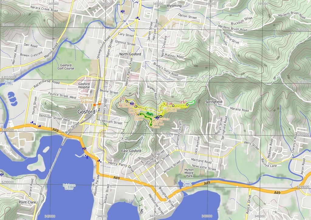
1 Upper Rumbalara circuit 1 hr 30 mins 3.3 km Circuit Hard track 176m A great circuit walk, covering most of the walking tracks and sights in the upper section of the Rumbalara Reserve. There is some really nice forest walking and plenty of spots along the way offer fantastic views across various parts of Gosford and the surrounding areas. Note that the entrance gate on Dolly Ave, for the upper section of Rumbalara, is locked at 8pm each evening m Maps, text & images are copyright wildwalks.com Thanks to OSM, NASA and others for data used to generate some map layers. 108m Rumbalara Reserve

2 Rumbalara Reserve Rumbalara Reserve lies just to the east of the Gosford CBD and is part of Gosford's Coastal Open Space System (COSS). There is an extensive set of well marked walking tracks within the reserve. Yaruga Picnic Area has free electric BBQs while both Yaruga and Nurrunga picnic areas have toilets, picnic tables, nearby lookouts and proximity to walking tracks. The picnic areas are accessed via Dolly Ave, Springfield, with the gate being locked at 8pm each evening. The Rumbalara Environmental Education Centre, at the end of Donnison St, Gosford, is one of several good access points to the walking tracks in the lower section of the reserve. More info. Yaruga Picnic Area This picnic area is right beside Dolly Ave, within the Rumbalara Reserve, Gosford. The facilities include free electric BBQs, picnic tables, toilets and garbage bins. There are information boards with details of the walking tracks and other features of the reserve. There are a couple of lookout points at the edge of the picnic area with great views out across Gosford and the surrounding areas. Flannel Flower Actinotus helianthi, popularly known as the Sydney flannel flower, is frequently spotted by spring-time bushwalkers in the Sydney region. Generally growing up to 50 cm, the stem, branches and leaves of the plant are a pale grey in colour, covered in downy hair (rather like flannel in texture). More info. Rumbalara Reserve Flora and Fauna The reserve is home to a wide range of flora and fauna. The vegetation types range from the relatively dry 'Coastal Narrabeen Ironbark Forest' to pockets of 'Coastal Warm Temperate Rainforest'. Commonly seen birds include Kookaburras, Eastern Rosellas and Magpies. Rarer birds such as the Glossy Black Cockatoo and Swift Parrot are sometimes sighted here as well. Sugar Gliders, Brushtailed possums, Blue-tounged lizards and Tree snakes can be seen in the reserve if you are patient and lucky enough. Sculptures in Rumbalara There are four bronze figurative sculptures in the Rumbalara Reserve that were 'commissioned in the series "Salute to Famous Australians", which includes Captain Charles Sturt, Edward Eyre, and Sir Charles Kingsford Smith.' Matthew Flinders is the fourth in the series. They were 'commissioned by Sara Lee Kitchens (Australia) Pty Ltd and Gosford City Council for the State Bicentennial Celebrations 1987.'. Smith and Flinders are the most easily reached, at the Nurrunga picnic area. More info. Before You walk Bushwalking is fun and a wonderful way to enjoy our natural places. Sometimes things go bad, with a bit of planning you can increase your chance of having an ejoyable and safer walk. Before setting off on your walk check 1) Weather Forecast (BOM Hunter District) 2) Fire Dangers (Greater Sydney Region) 3) Park Alerts () 4) Research the walk to check your party has the skills, fitness and equipment required 5) Agree to stay as a group and not leave anyone to walk solo Think before you TREK The 'Think before you TREK' program developed by NSW Police & NPWS promotes the benefits of planning ahead for your bushwalking trip by using an easy to remember acronym: T R E K Take adequate supplies of food, water, navigation and first aid equipment. Register your planned route and tell friends and family when you expect to return. Emergency beacon (PLB's) should be carried on walks with significant gaps in mobile coverage (check terrain profile). Keep to your planned route and follow the map and walking trails. Topo Maps The maps provided on wildwalks are helpful, but there are times where you may need maps covering a broader area. Maps that cover this walk include; 1: Map Series:91312S GOSFORD 1: Map Series:9131 GOSFORD Grade This walk has been graded using the AS The overall grade of the walk is dertermined by the highest classification along the whole track. 4 Length Time Quality of track Grade 4/6 Hard track 3.3 km Circuit 1 hr 30 mins Formed track, with some branches and other obstacles (3/6) Signs Minimal directional signs (4/6) Experience Required Weather Infrastructure Some bushwalking experience recommended (3/6) Weather generally has little impact on safety (1/6) Limited facilities, not all cliffs are fenced (3/6)
3 Are you ready to have fun? Please ensure you and your group are well prepared and equipped for all possible hazards and delays. Check park closures, weather information and Fire Danger Rating before setting out. Optional side trips and alternate routes noted are not included in this walks overall grade, length or time estimate. Please allow extra time for resting and exploring areas of interest. The authors, staff and owners of wildwalks take care in preparing this information but will not accept responsibility for any inconvenience, loss or injury you may experience. Please take care, have fun - Happy Walking. Getting there Traveling by car is the only practical way to get to Yaruga Picnic Area BBQs (gps: , ). Car: There is free parking available. This is a circuit, so you will finish back at the start. Find up to date and more information inlcuding; travel directions, weather, park closures and walker feedback at 0 Rumbalara Reserve Rumbalara Reserve lies just to the east of the Gosford CBD and is part of Gosford's Coastal Open Space System (COSS). There is an extensive set of well marked walking tracks within the reserve. Yaruga Picnic Area has free electric BBQs while both Yaruga and Nurrunga picnic areas have toilets, picnic tables, nearby lookouts and proximity to walking tracks. The picnic areas are accessed via Dolly Ave, Springfield, with the gate being locked at 8pm each evening. The Rumbalara Environmental Education Centre, at the end of Donnison St, Gosford, is one of several good access points to the walking tracks in the lower section of the reserve. More info. 0 Yaruga Picnic Area This picnic area is right beside Dolly Ave, within the Rumbalara Reserve, Gosford. The facilities include free electric BBQs, picnic tables, toilets and garbage bins. There are information boards with details of the walking tracks and other features of the reserve. There are a couple of lookout points at the edge of the picnic area with great views out across Gosford and the surrounding areas. 0 Yaruga Picnic Area BBQs (720 m 17 mins) From the BBQs, this walk goes across the picnic area, keeping the road to the right. The walk passes the information board, to the left, and follows the paved path toward the nearby toilet block. The walk turns left just before the toilet block and follows the 'Nurrunga Picnic Area' arrow down the paved steps and along the bush track. The walk descends gently for a while with numerous sandstone steps, then meanders around the side of the hill, for some distance. Ignoring a bush track, to the left, and another soon after, to the right, the walk continues for some distance until reaching an intersection with a management trail, with a 'Flannel Flower Track' signpost pointing back to the 'Yaruga Picnic Area' Flannel Flower Actinotus helianthi, popularly known as the Sydney flannel flower, is frequently spotted by spring-time bushwalkers in the Sydney region. Generally growing up to 50 cm, the stem, branches and leaves of the plant are a pale grey in colour, covered in downy hair (rather like flannel in texture). More info Flannel Flower walk signpost (30 m 1 mins) Veer left: From the intersection, this walk follows the management trail down the hill, towards the views of Gosford. After a very short distance, the walk arrives at an intersection with a paved path, signposted 'Casuarina Track' Int of Casuarina walk and Flannel Flower walk (180 m 5 mins) Turn right: From the intersection, this walk follows the 'Nurrunga Picnic Area' arrow along the paved track, keeping the views of Gosford to the left. The walk climbs gently for a short distance before arriving at a track junction with signposts for the 'Ironbark Loop', the 'Casuarina Track' and the 'Flannel Flower Track' Rumbalara Reserve Flora and Fauna The reserve is home to a wide range of flora and fauna. The vegetation types range from the relatively dry 'Coastal Narrabeen Ironbark Forest' to pockets of 'Coastal Warm Temperate Rainforest'. Commonly seen birds include Kookaburras, Eastern Rosellas and Magpies. Rarer birds such as the Glossy Black Cockatoo and Swift Parrot are sometimes sighted here as well. Sugar Gliders, Brush-tailed possums, Blue-tounged lizards and Tree snakes can be seen in the reserve if you are patient and lucky enough Junction of Ironbark, Casuarina and Flannel flower (180 m 4 mins) Turn left: From the track junction, this walk follows the 'Loop to Gosford' arrow (Casuarina Track) along the bush track, directly away from the nearby car park. After a short distance, the walk arrives at an intersection signposted for the 'Casuarina Track' and the 'Ironbark Loop'. At the time of writing, this part of the Casuarina Track, going down the hill, was closed. Continue straight: From the intersection, this walk follows the 'Nurrunga Picnic Area' arrow (Ironbark Loop sign), along the bush track, keeping the views of Gosford to the left. After a short distance, the walk arrives at an intersection, with an 'Ironbark Loop' signpost pointing back 'To Casuarina Track', beside a sculpture of Matthew Flinders Matthew Flinders sculpture (40 m 1 mins) Continue straight: From the intersection, this walk follows the bush track in the opposite direction to the 'To Casuarina Track' arrow, leaving the sculpture behind on the right. The walk then goes across the end of the picnic area to the sculpture of Sir Charles Kingsford Smith Sculptures in Rumbalara There are four bronze figurative sculptures in the Rumbalara Reserve that were 'commissioned in the series "Salute to Famous Australians", which includes Captain Charles Sturt, Edward Eyre, and Sir Charles Kingsford Smith.' Matthew Flinders is the fourth in the series. They were 'commissioned by Sara Lee Kitchens (Australia) Pty Ltd and Gosford City Council for the State Bicentennial Celebrations 1987.'. Smith and Flinders are the most easily reached, at the Nurrunga picnic area. More info Sir Charles Kingsford Smith sculpture (280 m 5 mins) Turn right: From the sculpture, this walk goes along the edge of the picnic area, in the direction pointed by Sir Charles' raised right elbow, keeping the picnic area to the right. The walk soon arrives at an 'Ironbark Loop' sign on the northern edge of the picnic area. Continue straight: From this 'Ironbark Loop' sign, this walk follows the 'To Casuarina Track' arrow along the management trail, initially keeping the picnic area to the right. The walk continues, passing a toilet block, to the right, then arrives at a sign, beside the road, pointing back to 'Nurrunga Picnic Area'. Continue straight: From the 'Ironbark Loop' sign, the walk immediately crosses the road and follows the bush track a little to a track junction with signposts for the 'Ironbark Loop', the 'Casuarina Track' and the 'Flannel Flower Track' Turn left: From the intersection, this walk follows the 'Loop to Yaruga Picnic Area' arrow between the metal posts and across the edge of the small car park. The walk immediately crosses the road to an intersection with a track, with a 'Flannel Flower Track' signpost pointing back to 'Yaruga Picnic Area' Western int of Flannel Flower walk and Dolly Ave (960 m 24 mins) Continue straight: From the intersection, this walk follows the 'Loop to Yaruga Picnic Area' arrow along the track, going gently down the hill. The walk meanders gently downhill for a short distance before passing under some power lines and continuing a little further to an intersection with a management trail. Veer right: From the intersection, this walk follows the management trail up the hill, keeping the nearby power lines to the right. After a short distance, the walk passes a management trail (to the right) and continues, passing some sort of underground pipe access point, on the left. After a while, the trail reaches an intersection with tracks to the left and right. Turn left: From the intersection, this walk follows the track down the steps, leaving the nearby water reservoir to the right. The track soon bends to the left at a rock outcrop, and winds down the hill for a while with plenty of steps. The walk levels out and meanders for a while, with occasional steps, to an intersection with a faint track, going down the hill to the left (just before the main track bends to the right and goes uphill a little). Veer right: From the intersection, this walk follows the track as it goes gently up the hill, immediately bending to the right. The walk meanders through some good scenery for a short distance before reaching the fenced Wannagan Lookout, with great views to the north Wannagan Lookout The fenced Wannagan Lookout, on the Red Gum Walk, has great views over North Gosford. The fenced lookout sits at the top of a small cliff. Out of sight, beneath the lookout, is some great cliff and overhang scenery Wannagan Lookout (290 m 6 mins) Turn right: From the intersection, this walk follows the track a very short distance up the hill, away from the lookout, then turns left (ignoring the track to the right which goes a short distance up the hill to the road). The walk meanders along the side of the hill for some distance, keeping the valley to the left, going up and down occasional steps before reaching an intersection with a management trail Optional sidetrip to Sculpture of Edward John Eyre (150 m 2 mins) Veer left: From the intersection, this walk follows the management trail away from the nearby gate (beside the road). The trail almost immediately bends to the right then meanders for a short distance to the sculpture of Edward John Eyre, on the right. At the end of this side trip, retrace your steps back to the main walk then Continue straight Int of Red Gum walk and Mouat Walk (600 m 13 mins) Turn right: From the intersection, this walk follows the management trail gently up the hill towards the gate. The walk passes around the gate to the intersection with Dolly Ave, with a 'Mouat Walk' signpost pointing back to the 'Statue of Edward John Eyre 50 metres'. Turn right: From the intersection, this walk follows the road gently up the hill, leaving the signposted 'Mouat Walk' behind on the right. After a short distance, the walk passes a small parking area and fenced lookout point, on the left, and continues along the road for some distance, passing a large water reservoir tank, to the right. A little further on the walk reaches an intersection with a bush track, to the right, marked by a low boulder (within sight of the sandstone walled Yaruga picnic area). Continue straight: From the intersection, this walk follows the road gently up the hill towards the sandstone walls of the nearby Yaruga picnic area. The walk climbs the first set of steps on the left, near the 'Yaruga Picnic Area' signpost, and goes across the picnic area to the nearby electric BBQs.
4
5 Powered by TCPDF ( Summary navigation sheet for the Upper Rumbalara circuit km From Up/Dwn Length Initial directions (Use full tracknotes and maps for more detail) 0.00 Yaruga Picnic Area BBQs , (GR Gosford, ) m 17 mins From the BBQs, this walk goes across the picnic area, keeping the road to the right Flannel Flower walk signpost , (GR Gosford, ) m 1 mins Veer left: From the intersection, this walk follows the management trail down the hill, towards the views of Gosford Int of Casuarina walk and Flannel Flower walk , (GR Gosford, ) m 5 mins Turn right: From the intersection, this walk follows the 'Nurrunga Picnic Area' arrow along the paved track, keeping the views of Gosford to the left Junction of Ironbark, Casuarina and Flannel flower walks , (GR Gosford, ) m 4 mins Turn left: From the track junction, this walk follows the 'Loop to Gosford' arrow (Casuarina Track) along the bush track, directly away from the nearby car park Matthew Flinders sculpture , (GR Gosford, ) m 1 mins Continue straight: From the intersection, this walk follows the bush track in the opposite direction to the 'To Casuarina Track' arrow, leaving the sculpture behind on the right Sir Charles Kingsford Smith sculpture , (GR Gosford, ) m 5 mins Turn right: From the sculpture, this walk goes along the edge of the picnic area, in the direction pointed by Sir Charles' raised right elbow, keeping the picnic area to the right Western int of Flannel Flower walk and Dolly Ave , (GR Gosford, ) m 24 mins Continue straight: From the intersection, this walk follows the 'Loop to Yaruga Picnic Area' arrow along the track, going gently down the hill Wannagan Lookout , (GR Gosford, ) m 6 mins Turn right: From the intersection, this walk follows the track a very short distance up the hill, away from the lookout, then turns left (ignoring the track to the right which goes a short distance up the hill to th Int of Red Gum walk and Mouat Walk , (GR Gosford, ) m 2 mins Optional sidetrip to Sculpture of Edward John Eyre. Veer left: From the intersection, this walk follows the management trail away from the nearby gate (beside the road) Int of Red Gum walk and Mouat Walk , (GR Gosford, ) m 13 mins Turn right: From the intersection, this walk follows the management trail gently up the hill towards the gate.
Rumbalara Explorer. 158m. 5m Rumbalara Reserve. 2 hrs 45 mins 6.1 km Circuit. Hard track 326m
 Rumbalara Explorer 2 hrs 5 mins 6.1 km Circuit Hard track 326m Pretty well the grand tour of the Rumbalara Reserve, this walk takes in much of the great scenery the reserve has to offer. The walk covers
Sid Pulsford Walk. 175m. 33m. 1 hr 45 mins 4.1 km One way. Hard track 118m. Gosford LGA
 Sid Pulsford Walk 1 hr 5 mins.1 km One way Hard track 118m Sid Pulsford Walk explores the ridge top of Kincumber Mountain, from Honeman's Rock to Green Point. The walk mostly follows wide management trails.
Echo Point to Leura Forest via Three Sisters and Giant Stairs loop
 Echo Point to Leura Forest via Three Sisters and Giant Stairs loop 3 hrs 3.8 km Circuit Hard track 512m This walk starts from the popular Echo Point, in Katoomba, and winds down to the base of the Three
Hunters Hill to Epping Road
 Hunters Hill to Epping Road 2 hrs 30 mins 5.5 km One way Moderate track 154m An enjoyable walk through lower sections of the Lane Cove National Park, this walk features plenty of mangroves next to the
Currie Rd to Davidson Park
 Currie Rd to Davidson Park 3 hrs 7.2 km One way Moderate track 28m Starting at Currie Rd in Forestville, this walk follows Middle Harbour to Davidson Park, under Roseville Bridge. There are two optional
Carrington Park to Leura Forest and pass loop
 Carrington Park to Leura Forest and pass loop 3 hrs Hard track 4.8 km Circuit 4 674m This walk is a fantastic way to see Leura Forest. The walk descends from Carrington Park, visiting Leura Forest and
Gosford to Lisarow. 202m
 Gosford to Lisarow 4 hrs 3 mins Hard track 11.3 km One way 4 479m This walk is a great way to explore the ridge-top bushland between Gosford and Lisarow. Passing through Rumbalara and Katandra Reserves,
Heathcote to Engadine via Audley
 Heathcote to Engadine via Audley 6 hrs 3 mins 5 km One way Hard track 4 635m Covering a large section of central Royal National Park, this walk goes through the heath and scrub along a well managed and
Rail to River Walk. 3 hrs. Hard track 7.5 km Circuit. 222m
 Rail to River Walk 3 hrs Hard track 7.5 km Circuit 4 222m This walk is a great one from Chatswood Station to the Lane Cove River National Park. The walk descends through the vegetated bushland which fills
Little Digger Track to Davidson Reserve and Lyrebird Circuit
 Little Digger Track to Davidson Reserve and Lyrebird Circuit 4 hrs 3 mins 11.5 km One way Hard track 4 47m Exploring both the eastern and western sides of Middle Harbour Creek, this walk follows the Little
Wentworth Falls Conservation Hut Loop
 Wentworth Falls Conservation Hut Loop 3 hrs Hard track 6.7 km Circuit 4 341m This scenic walk from Wentworth Falls Station, winds along the Nature Trail to Conservation Hut, then drops into the magnificent
Little Digger Track. 68m. 1 Hr 2.2 km One way. Moderate track 93m. Moores Creek Reserve
 Little Digger Track Hr 2.2 km One way Moderate track 93m This walk follows Moores Creek through several reserves in east Roseville and East Lindfield. The track is named after Australia's 7th Prime Minster,
The Foreshore Walk. 24m. 1m Lake Macquarie LGA. 1 hr 15 mins 2.9 km One way. Hard track 81m
 The Foreshore Walk 1 hr 15 mins 2.9 km One way Hard track 81m This walk traverses the coastline of the Green Point reserve. By following a variety of tracks and occasionally traveling inland through eucalyptus
Govetts Leap Loop. 1065m. 909m Blue Mountains National Park. 4 hrs 30 mins 8.7 km Circuit. Hard track 380m
 Govetts Leap Loop 4 hrs 30 mins 8.7 km Circuit Hard track 380m This walk, from Blackheath Train Station, is a fantastic way to see some of the iconic areas of the Blue Mountains in the Blackheath area.
Wattamolla to Big Marley Beach
 Wattamolla to Big Marley Beach 4 hrs 10.4 km Circuit Moderate track 4m This walk is an excellent loop which takes in both the coast and the heathy inland of Royal National Park. Nearly the whole walk has
Wallarah Coastal Walk
 Wallarah Coastal Walk 3 hrs 8.3 km Return Hard track 247m This walk starts at Caves Beach and travels south along the coastline, until reaching the Pinney s Headland Lookout. There are many opportunities
Katoomba Falls Circuit
 Katoomba Falls Circuit hr 5 mins.5 km Circuit Hard track 59m For those looking for a walk involving more than simple boardwalk, this trail winding through the temperate rain forest could be just the thing.
Popes Glen, Pulpit Rock, Govetts Leap and Braeside Walk
 Popes Glen, Pulpit Rock, Govetts Leap and Braeside Walk 8 hrs Hard track 13.6 km Circuit 4 1068m This large circuit walk, from Popes Glen to Pulpit Rock, Govetts leap and along the Braeside Track, passes
Morgans Creek to Padstow
 Morgans Creek to Padstow 2 hrs 45 mins 8 km One way Moderate track 3 144m This pleasant walk starts from the Morgans Creek park, at Henry Lawsons Drive, and follows the Georges River past the Boomerang
Waterfall to Heathcote
 Waterfall to Heathcote 5 hrs Hard track 10.8 km One way 4 467m This walk explores the heart of Heathcote National Park, and is easily accessed with a train station at either end. Although relatively close
Hornsby Blue Gum Walk
 Hornsby Blue Gum Walk 3 hrs Hard track 6.7 km Circuit 4 374m This delightful loop is one of the prettiest and most popular walks in the Hornsby area. Going from an environment of ferns and clear bushland
Epping to Pennant Hills Station (via Lane Cove River)
") Epping to Pennant Hills Station (via Lane Cove River) 3 hrs 5 mins 8.4 km One way Hard track 249m This walk, from Epping to Pennant Hills Station, is a great way to see the upper Lane Cove River Valley.
Epping to Pennant Hills Station (via Lane Cove River) 3 hrs 5 mins 8.4 km One way Hard track 249m This walk, from Epping to Pennant Hills Station, is a great way to see the upper Lane Cove River Valley.
Callicoma Loop. 174m. 98m. 2 hrs. Hard track 5.1 km Circuit. 153m
 Callicoma Loop 2 hrs Hard track 5.1 km Circuit 153m This great circuit walk passes through some really nice forest around the fringe of Cherrybrook. Highlights of the walk include some beautiful rock overhangs
Dead Horse Gap Loop track
 Dead Horse Gap Loop track 4 hrs 30 mins Hard track 9.8 km Circuit 144m 4 This walk starts with a ride up the Kosciuszko Express Chairlift. There is an opportunity to eat at Australia's highest restaurant,
Campbell Drive to Snapper Point
 Campbell Drive to Snapper Point 1 hr 45 mins 4.2 km One way Experienced only 135m This walk follows the Coast Track to Frazer Beach, along the Geebung and (overgrown) Grass Tree Tracks. From the northern
Scenic World to Echo Point
 Scenic World to Echo Point 1 hr 15 mins 2.1 km One way Moderate track 192m This is one of the most popular tourist walks in the Katoomba area. The walk follows the cliffs along a well maintained and signposted
Mackerel Beach, West Head Loop
 Mackerel Beach, West Head Loop 5 hrs 8.6 km Circuit Hard track 422m The Mackerel Beach, West Head Loop is a walk which explores a large part of the West Head. The journey starts and finishes with a ferry
Epping to Eastwood Station (via Lane Cove River)
") Epping to Eastwood Station (via Lane Cove River) hrs 45 mins 10.2 km One way Moderate track 189m Epping to Eastwood, via Lane Cove River, is the longer route through the bush between the stations. This
Epping to Eastwood Station (via Lane Cove River) hrs 45 mins 10.2 km One way Moderate track 189m Epping to Eastwood, via Lane Cove River, is the longer route through the bush between the stations. This
Middle Harbour Creek Loop
 Middle Harbour Creek Loop 5 hrs 45 mins 15.1 km Circuit Experienced only 5 570m This walk explores the upper reaches of Middle Harbour Creek, starting and ending at the great parklands at Davidson Park,
Teralba to Charlestown Park track head
 Teralba to Charlestown Park track head 4 hrs 30 mins 13.3 km One way Moderate track 3 220m This section of the Great North Walk starts from the Teralba train station and winds down and around the edge
The Basin Track and Mackerel Track
 The Basin Track and Mackerel Track 3 hrs 5.9 km Circuit Hard track 226m This walk is a great way to see some popular areas in Ku-ring-gai Chase National Park. The walk from West Head Rd travels to The
Bouddi Coastal Walk. 5 hrs. Hard track 8.1 km One way. 364m
 Bouddi Coastal Walk 5 hrs Hard track 8.1 km One way 4 364m This is one of the longer walks in the Bouddi National Park and it is rich in scenery. The walk follows the coastline with many side trips to
Sphinx, Warrimoo and Bobbin Head tracks
 Sphinx, Warrimoo and Bobbin Head tracks 4 hrs 9.6 km Circuit Moderate track 499m This great walk starts at the Sphinx Memorial and loops around via Cowan Creek, exploring diverse environments as it changes
Rail to River and Stringybark Creek Reserve Walk
 Rail to River and Stringybark Creek Reserve Walk 4 hrs Hard track 11.2 km Circuit 4 302m This walk begins in the busy city of Chatswood and soon enters the nearby bushland around the Lane Cove River. The
Green Point Circuit Walk
 Green Point Circuit Walk 3 hrs 7.7 km Circuit Hard track 269m This walk visits all of the popular locations in Green Point Reserve, as well as some of the lesser-visited areas inland. Taking in Sea Eagle
Woolwich Wharf to Boronia Park
 Woolwich Wharf to Boronia Park 2 hrs 5.8 km One way Moderate track 175m Going through the streets of Hunters Hill, this walk is on the first segment of the Great North Walk. The majority of the walk is
Balmoral Beach to The Spit
 Balmoral Beach to The Spit 2 hrs 30 mins.3 km One way Hard track 85m This walks follows the coast from Balmoral to the Spit and across Spit Bridge. There are some alternate tracks to consider at high-tides,
Mackerel Beach and Resolute Loop
 Mackerel Beach and Resolute Loop 3 hrs 5.4 km Circuit Hard track 384m This walk is another great walk in Ku-ring-gai Chase National Park, accessed by ferry. From the Mackerel Beach wharf, this walk uses
Patonga to Woy Woy. 5 hrs 45 mins 15.5 km One way. Hard track. 497m
 Patonga to Woy Woy 5 hrs 45 mins 15.5 km One way Hard track 4 497m This walk explores a variety of environments from the shore line and coastal cliffs near Patonga, to the dry, rocky and open ridge line.
Dubbo Gully and Ten Mile Hollow Circuit (via Clares Bridge)
") Dubbo Gully and Ten Mile Hollow Circuit (via Clares Bridge) 2 Days Hard track 24.3 km Circuit 4 1117m This two day (or ten hour) walk follows several historic roads, now closed to traffic. Starting with
Dubbo Gully and Ten Mile Hollow Circuit (via Clares Bridge) 2 Days Hard track 24.3 km Circuit 4 1117m This two day (or ten hour) walk follows several historic roads, now closed to traffic. Starting with
Under and Over Cliff Walk
 Under and Over Cliff Walk 4 hrs 9.4 km Circuit Moderate track 576m This walk from Wentworth Falls Station is a fantastic way to see a large majority of the Wentworth Falls cliffline. The track winds under
Berowra to Mt Kuring-gai
 Berowra to Mt Kuring-gai 4 hrs 30 mins 9.4 km One way Hard track 4 551m From the ridges above Cowan Creek, this walk takes in some great lookouts (especially around Mt Kuringgai) as well as enjoying an
Blackheath Station to Junction Rock Loop (via Grand Canyon and Popes
 Blackheath Station to Junction Rock Loop (via Grand Canyon and Popes 8 hrs 30 mins 18.2 km Circuit Hard track 4 1254m This circuit starts in Blackheath and heads down into the Grand Canyon and Rodriguez
National Pass from Wentworth Falls to Conservation Hut
 National Pass from Wentworth Falls to Conservation Hut 3 hrs Hard track 3.6 km One way 739m Starting at Wentworth Falls picnic area, this scenic and historic walk explores many waterfalls, lookouts and
De Burgs Bridge to Thornleigh station
 De Burgs Bridge to Thornleigh station 3 hrs 45 mins 9.7 km One way Hard track 4 363m This walk follows a section of the Great North Walk, starting from De Burghs bridge. The walk winds north west, through
De Burghs Bridge to Fullers Bridge
 De Burghs Bridge to Fullers Bridge 2 hrs 3 mins Hard track 6 km One way 2m 4 Following the Lane Cove River, this walk mostly follows a section of the Great North Walk and is well maintained and signposted.
Glenbrook and Euroka Circuit
 Glenbrook and Euroka Circuit 2 Days 16.6 km Circuit Experienced only 790m This two day circuit, returning to Glenbrook Station, is a scenic walk which passes many of the tourist attractions within the
Taronga Wharf to Chowder Bay
 Taronga Wharf to Chowder Bay 2 hrs 4.4 km One way Moderate track 246m Starting at Taronga Wharf, this walk passes many icons of Sydney, including Taronga Zoo, HMAS Sydney Mast, Chowder Bay. The walk also
Wentworth Falls Station Loop (Undercliff Walk)
") Wentworth Falls Station Loop (Undercliff Walk) 4 hrs 3 mins Hard track 8.9 km Circuit 658m 4 This walk passes some stunning waterfalls and views into the Jamison Valley, following the cliff edges around
Wentworth Falls Station Loop (Undercliff Walk) 4 hrs 3 mins Hard track 8.9 km Circuit 658m 4 This walk passes some stunning waterfalls and views into the Jamison Valley, following the cliff edges around
Federal Pass Walking Track
 Federal Pass Walking Track 5 hrs Hard track 8 km One way 4 989m This classic trail follows along the base of the cliffs from Leura to the Golden Stairs, passing many of the more popular sights of the Katoomba
Spit Bridge to Middle Head Forts
 Spit Bridge to Middle Head Forts 2 hrs 30 mins 6.3 km One way Hard track 4 181m This scenic walk takes you from the Spit Bridge, along the coast to explore the Middle Head Forts. There are a few alternate
Echo Point to Leura Forest Circuit
 Echo Point to Leura Forest Circuit 3 hrs 4.8 km Circuit Hard track 588m Forming a circuit around the cliffs and then the valley floor, this is a walk more then capable of convincing a walker of the beauty
Lane Cove Tourist Park River Circuit
 Lane Cove Tourist Park River Circuit 5 hrs 12 km Circuit Hard track 383m This walk follows a large section of Lane Cove River. The walk follows the Riverside Walking track up the Lane Cove River to De
Hermitage Foreshore Track
 Hermitage Foreshore Track 1 Hr 2.2 km One way Moderate track 123m The Hermitage Foreshore Walk is a wonderful way to explore Sydney Harbour from the perspective of South Head. This walk starts from Nielsen
Epping to Gordon Station
 Epping to Gordon Station 4 hrs 15 mins 11.7 km One way Hard track 4 365m This walk, from Epping Station to Gordon Station, passes below the homes which sit on the hills high above the Lane Cove River.
Thornleigh to Hornsby
 Thornleigh to Hornsby 4 hrs Hard track 10.2 km One way 4 526m Starting at Thornleigh station you walk through suburban streets for a short while before diving into the bush at the southern end of Berowra
Roseville to Macquarie Park
 Roseville to Macquarie Park 3 hrs 3 mins 8.8 km One way Hard track 4 29m This walk starts at Roseville station and explores the streets and alleyways of Roseville before joining the main spine of the Great
Gordon to Chatswood Station
 Gordon to Chatswood Station 4 hrs 30 mins 12.2 km One way Hard track 4 381m This walk is a great way to get into the bush without being far from civilisation. The walk wanders through untouched valleys
Wentworth Falls Loop. 893m. 665m. 6 hrs 10.2 km Circuit. Hard track 1093m. Blue Mountains National Park
 Wentworth Falls Loop 6 hrs 1.2 km Circuit Hard track 193m This is a great walk, both in size and spectacular views. The walk makes its way from Wentworth Falls train station and drops off the plateau,
Wentworth Falls Station Loop
 Wentworth Falls Station Loop 5 hrs 3 mins 9.5 km Circuit Hard track 4 13m The Wentworth Falls Station Loop takes in most of the upper tracks around Wentworth Falls. There are many scenic views near the
Faulconbridge to Blaxland
 Faulconbridge to Blaxland 2 Days Experienced only 15.2 km One way 5 693m This two-day walk, or very solid one-day walk, takes you from station to station, through lush, scenic forest in the lower Blue
Scenic world to Three Sisters Loop via Furber Steps
 Scenic world to Three Sisters Loop via Furber Steps 5 hrs 5.8 km Circuit Hard track 722m This walk starts from the popular Scenic World, in Katoomba, and winds down the Furber steps into the Jamison Valley,
North Ryde Fairyland circuit
 North Ryde Fairyland circuit 2 hrs 30 mins Hard track 6.9 km Circuit 193m 4 Starting at North Ryde train station this walk explores a stretch of the Lane Cove River, visiting the historic Fairlylands Pleasure
Sphinx to Mt Kuring-gai
 Sphinx to Mt Kuring-gai 4 hrs 45 mins 1.7 km One way Hard track 673m This walk starts at the Sphinx War Memorial and follows some well maintained and popular walking tracks down to Cowan Creek. Enjoy the
Charlestown Park trackhead to Newcastle station
 Charlestown Park trackhead to Newcastle station 5 hrs 30 mins 12.1 km One way Hard track 4 287m This section of the Great North Walk starts from the Charleston Park track head and winds through the streets
Bouddi Ridge and Coastal Walk
 Bouddi Ridge and Coastal Walk 2 Days Hard track 27 km Circuit 4 126m This overnight walk takes in the majority of the magnificent Bouddi National Park. The walk starts from the pleasant Putty Beach camping
The Coast Track. 2 Days. Hard track 27.4 km One way. 1351m
 The Coast Track 2 Days Hard track 27.4 km One way 4 1351m Heading south, this walk covers the coastline of the Royal National Park and can truly only be described as amazing. With breathtaking coastal
Bobbin Head Loop. 166m. 0m Ku-ring-gai Chase National Park. 5 hrs 12.9 km Circuit. Hard track 619m
 Bobbin Head Loop 5 hrs 12.9 km Circuit Hard track 619m This great circuit walk enjoys a variety of landscapes in Ku-ring-gai Chase National Park. The walk starts at the historic Sphinx war memorial and
Narrabeen Lagoon Trail (from Middle Creek)
") Narrabeen Lagoon Trail (from Middle Creek) 2 hrs 30 mins 8.6 km Circuit Very easy 1 105m The Narrabeen Lagoon Trail is a wonderful and accessible walk on the Northern Beaches of Sydney. The trail is used
Narrabeen Lagoon Trail (from Middle Creek) 2 hrs 30 mins 8.6 km Circuit Very easy 1 105m The Narrabeen Lagoon Trail is a wonderful and accessible walk on the Northern Beaches of Sydney. The trail is used
Cape Banks Circuit. 50m. 2m Botany Bay National Park. 3 hrs 7.3 km Circuit. Hard track 190m
 Cape Banks Circuit 3 hrs 7.3 km Circuit Hard track 19m This Cape Banks Circuit has a lot to offer and is thoroughly recommended. The walking travels over beaches, through coastal forest and across exposed
Chatswood to Epping Station
 Chatswood to Epping Station 6 hrs Hard track 16.3 km One way 4 533m This walk, from Chatswood to Epping, is a long but enjoyable walk along the Lane Cove valley. The walk mostly follows the Lane Cove River
Spit Bridge to Manly (Manly Scenic Walkway)
") Spit Bridge to Manly (Manly Scenic Walkway) 3 hrs 45 mins 9.1 km One way Moderate track 349m The Spit to Manly walk is a classic bushwalk on Sydney's Northern Beaches. The walk follows a well-maintained
Spit Bridge to Manly (Manly Scenic Walkway) 3 hrs 45 mins 9.1 km One way Moderate track 349m The Spit to Manly walk is a classic bushwalk on Sydney's Northern Beaches. The walk follows a well-maintained
Taronga Zoo to Spit Bridge
 Taronga Zoo to Spit Bridge 5 hrs Hard track 1.4 km One way 4 41m This is a scenic and culturally rich walk with views over Sydney Harbour and many interesting heritage buildings along the way. The start
Six Foot Track. 1212m
 Six Foot Track 3 Days 44.8 km One way Hard track 4 2066m This classic walk takes you from Katoomba to Jenolan Caves via a historic horse route. The walk travels mainly along well-maintained service tracks
Manly to Seaforth Oval
 Manly to Seaforth Oval 5 hrs 45 mins 13.7 km One way Moderate track 3 624m This walk follows the Manly to Spit Scenic Walkway, then continues past The Spit Bridge to Seaforth Oval. The walk provides magnificent
Light to Light Walk 2 days
 Light to Light Walk 2 days 2 Days Hard track 3.9 km One way 4 794m Over two days, this classic walk explores the coast from Boyd Tower to the Green Cape Lighthouse in the south. Hegartys Bay Camp is over
Sydney to Thornleigh via Lane Cove Tourist Park
 Sydney to Thornleigh via Lane Cove Tourist Park 2 Days 33 km One way Hard track 4 1114m This overnight walk starts from the Obelisk in Macquarie Park, Sydney, at the official start of the Great North Walk.
Harbour Bridge to Taronga Zoo
 Harbour Bridge to Taronga Zoo 4 hrs 9.8 km One way Moderate track 389m On this walk, you will explore much of the foreshore linking Milsons Point Station to Taronga Zoo Ferry wharf. The walk is mostly
Harlington - Sharpenhoe - Pulloxhill
 Harlington - Sharpenhoe - Pulloxhill ID: 3676, Distance: 8 miles, Height gain: 140 Metres, Map: Explorer 193 Luton & Stevenage, Contributor: Dennis Jeanes Duration: 3 Hours 27 Mins Features Church,Great
Start / Finish. Version 2
 Start / Finish Version 2 Gosford (Start) to Woy Woy Head South down Etna Street, crossing Henry Parry Drive, then Mann St, Gosford, where Etna St becomes Racecourse Road. Follow this road all the way
Beautiful Walks from the Blue Ball Inn
 Walk No. 7 COAST AND VALLEY WALK Countisbury, Glenthorne, County Gate, Brendon, Rockford and Wilsham 10 MILES APPROX. Walking time 5 hours approx. (not including breaks)> OS Sheet 64/74 Lynton and Lynmouth.
Tenerife Sur: Short Walks Under 10 km. Santiago del Teide Almond Blossom
 Tenerife Sur: Short Walks Under 10 km Santiago del Teide Almond Blossom Route Summary This delightful circular walk is especially beautiful when the almond trees are in flower during January and February
THE WELLDIGGERS ARMS, HESWORTH AND FITTLEWORTH TRAIL
 THE WELLDIGGERS ARMS, HESWORTH AND FITTLEWORTH TRAIL 5.5 miles Circular 3 hours 041017 Challenging Terrain A 300-year-old pub turned country-inn on the edge of the South Downs National Park, The Welldiggers
Route: Skewsby Foulrice Stearsby
 Route: Skewsby Foulrice Stearsby Distance: 7 miles Map: Explorer: 300 Howardian Hills & Malton Start (OS ref): SE625710 Park in the village of Skewsby. Walk east out of the village to the T-Junction and
MELBOURNE MIDDAY MILERS MARCH MADNESS BARWON HEADS 5MS RELAY
 MELBOURNE MIDDAY MILERS MARCH MADNESS BARWON HEADS 5MS RELAY 2013 Pre-race admin 1. We will meet at 8.15am on Sunday 17 March in the car park opposite the Barwon Heads Hotel & fronting the beach on Ewing
Masson Hill. Walk. Approximately 4 km. Moderate Walk Begins from Matlock Railway Station
 Masson Hill Walk Approximately 4 km Moderate Walk Begins from Matlock Railway Station TOWN WALKS Masson Hill walk is approx. 4 km. It can be walked in a couple of hours or so. Enjoy your walk and the beautiful
Stokenchurch. Bluebell Woods, Bomber Memorial, Red Kites, Getty s Cricket Ground, Nature Reserve
 Stokenchurch Bluebell Woods, Bomber Memorial, Red Kites, Getty s Cricket Ground, Nature Reserve Bomber Memorial The best time to visit Cowleaze Wood is in the spring when there is a memorable display of
MAPS & WALK NOTES. DAY 2: Greenwich Wharf to Woolwich Wharf
 MAPS & WALK NOTES DAY 2: Greenwich Wharf to Woolwich Wharf Total Distance: 15.5km Time: Approximately 5 hours 30 mins five Sections Walk Notes in Section Name Length Time 2:1 Greenwich Wharf to Northwood
VERN S CAMP from Minginui
 VERN S CAMP from Minginui Map: Kuratau, 1:50,000 V18 Refer Figures 1, 3, 4 and 5 GPS: Geodetic Datum 1949 Refer Figure 10a (Geographic) and 10b (NZ Grid) How to get to START: From the police station on
Tideswell to Castleton
 Tideswell to Castleton 1 Walk summary Length: 14 km, 8.5 miles Maps: OS Explorer OL1 The Peak District - Dark Peak Area, OS Explorer OL24 The Peak District - White Peak Area, OS Landranger 110 Sheffield
VELINDRE VALLEYS WALK FOR STEFFAN
 VELINDRE VALLEYS WALK FOR STEFFAN IMPORTANT INFORMATION FOR WALKERS AND MARSHALS 1 Table of Contents Key Contact Numbers:... 3 Timetable and locations... 4 T-shirts... 4 Important Advice for Walkers...
For more information and to buy this book click here ISBN: CICERONE. Guides for walkers, trekkers, mountaineers, climbers and cyclists
 For more information and to buy this book click here ISBN: 9781852845377 CICERONE Guides for walkers, trekkers, mountaineers, climbers and cyclists www.cicerone.co.uk WALK 5 Ouston and Urpeth Distance
Bonnie Prince Charlie Walk
 Bonnie Prince Charlie Walk A waymarked route from Ashbourne to Derby to celebrate the 60th anniversary (1995) of the formation of the Ramblers' Association. This route follows the general direction of
RILLINGTON TO MALTON by Tania Dickinson
 RILLINGTON TO MALTON by Tania Dickinson This walk takes you from the Vale of Pickering up on to the Wold scarp, before dropping down again through the pretty village of Settrington and joining the Centenary
Calaveras Big Trees State Park--South Grove Loop
 Copyright 1999 by Jeff Robinson. You are free to use and reproduce this description for personal, not-for-profit, and not-forbusiness use. Any reproduction other than for personal use, including businesses,
Slindon Folly - South Downs, West Sussex
 Slindon Folly - South Downs, West Sussex Starts at Park road-side near entrance to Slindon College 2 hours 15 minutes 4.5miles 7.2km Easy ID: 0.1598 Developed by: Chris Mumford Checked by: Rockpit www.ramblersroutes.org
CREW MAPS and DIRECTIONS GH100, 2016
 CREW MAPS and DIRECTIONS GH100, 2016 Checkpoint 1 Checkpoint is 3km along Caves Rd at the second intersection of the Trachyte Circuit Walking Trail. Crew Route No crew allowed access to Checkpoint 1. Checkpoint
Rhossili - Tears Point - Mewslade Bay - Talgarth's Well - Rhossili - ID: 148. Walk description:
 Walk description: A glorious walk combining thrilling cliffs with beautiful wild beaches and a bird's-eye view of the Gower peninsula from Rhossili Down. The adventurous can walk out to the Worm's Head
Corkagh Park Maths Trail
 Open your Corkagh Park Maths Trail In association with: This trail begins at the noticeboard at the entrance near the St John s Wood car parks in Corkagh Park The producers of this Maths Trail accept no
COSTA BLANCA MOUNTAIN WALKERS - WALK DESCRIPTION. Visit for more walks descriptions in Spain
 COSTA BLANCA MOUNTAIN WALKERS - WALK DESCRIPTION Visit www.walksinspain.org for more walks descriptions in Spain Walk description originally prepared by:- Ralph Phipps Last Updated 18 th April 2015 Title