Gordon to Chatswood Station
|
|
|
- Conrad Hopkins
- 5 years ago
- Views:
Transcription


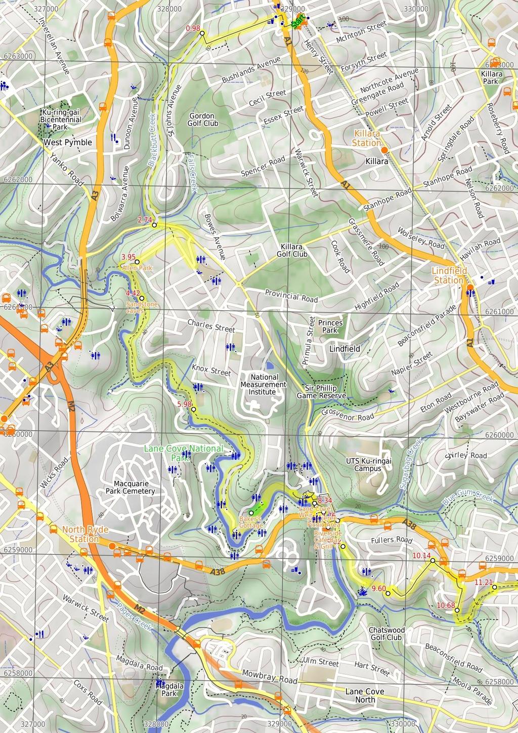
1 Gordon to Chatswood Station 4 hrs 30 mins 12.2 km One way Hard track 4 381m This walk is a great way to get into the bush without being far from civilisation. The walk wanders through untouched valleys and along the Lane Cove River, passing over many roads and footpaths to connect such unspoilt bush. The side trip to Baker's cottage is definitely worth the short stroll, with the heritage building having a long history. 122m 1m Lane Cove National Park Maps, text & images are copyright wildwalks.com Thanks to OSM, NASA and others for data used to generate some map layers.

2 Allen Park Before You walk Allen Park is a very small grassed clearing at the end of Blaxland Rd. The park is not shaded and backs onto a house. The park is a thoroughfare to access the Great North Walk from Blaxland Rd. Bushwalking is fun and a wonderful way to enjoy our natural places. Sometimes things go bad, with a bit of planning you can increase your chance of having an ejoyable and safer walk. Before setting off on your walk check Sandstone caves This fairly large sandstone overhang is found on the eastern side of the Lane Cove Valley. The walking track leads through the two caves that run in series, with the northern cave being larger. The lip of the overhang hangs down a bit, providing some extra protection from wind and rain. The cave also provide some shade and a cooler spot on hot days, and there are also a couple of well placed boulders forming nice seats. Baker's Cottage Baker's Cottage was built in 1865 as the residence of William Baker and his family. The cottage once stood in the middle of a well-kept garden and orchard. The cottage itself was once larger, with more rooms and a verandah surrounding it. The residence changed hands only twice, and was then appropriated by the Minister of Lands in Lane Cove Weir The Lane Cove River Weir was built in 1938 during the depression. The motivation for building the lake was to make the area more apealing for visitors' picnics. The weir created environmental issues such as silting and a decline in native fish populations. In much more recent years, a 'fish ladder' has been construcuted to allow fish to undertake their natural migration route for breeding. The weir proved an easy way for walkers to cross the Lane Cove River whilst enjoying the views up and downstream. Koonjeree Picnic Area Koonjeree Picnic Area is at the southern end of Lane Cove National Park, just near Fullers Bridge. The picnic area boasts free gas barbecues, flushing toilets, town tap water, picnic tables and shelters, a large open area and car parking. On the bank of the Lane Cove River, this is a pleasant spot to enjoy the park. Riverside Cafe Bar & Grill The Riverside Cafe is found at the end of service road on the southwest corner of Fullers Bridge. The nicely renovated building looks over the Lane Cove River and is open 7 days, serving breakfast, lunch and dinner. The food is cafe-style and meals are priced upwards from $13. Ph: (02) ) Weather Forecast (BOM Metropolitan District) 2) Fire Dangers (Greater Sydney Region, unknown) 3) Park Alerts (Lane Cove National Park) 4) Research the walk to check your party has the skills, fitness and equipment required 5) Agree to stay as a group and not leave anyone to walk solo Think before you TREK The 'Think before you TREK' program developed by NSW Police & NPWS promotes the benefits of planning ahead for your bushwalking trip by using an easy to remember acronym: adequate supplies of food, water, navigation and first T Take aid equipment. your planned route and tell friends and family when R Register you expect to return. beacon (PLB's) should be carried on walks with E Emergency significant gaps in mobile coverage (check terrain profile). to your planned route and follow the map and walking K Keep trails. Topo Maps The maps provided on wildwalks are helpful, but there are times where you may need maps covering a broader area. Maps that cover this walk include; 1: Map Series:91303N PARRAMATTA RIVER 1: Map Series:9130 SYDNEY Grade This walk has been graded using the AS The overall grade of the walk is dertermined by the highest classification along the whole track. 4 Grade 4/6 Hard track Length 12.2 km One way Time 4 hrs 30 mins Quality of track Rough track, where fallen trees and other obstacles are likely (4/6) Signs Directional signs along the way (3/6) Experience Required Some bushwalking experience recommended (3/6) Weather Weather generally has little impact on safety (1/6) Infrastructure Limited facilities, not all cliffs are fenced (3/6)
3 Are you ready to have fun? Please ensure you and your group are well prepared and equipped for all possible hazards and delays. Check park closures, weather information and Fire Danger Rating before setting out. Optional side trips and alternate routes noted are not included in this walks overall grade, length or time estimate. Please allow extra time for resting and exploring areas of interest. The authors, staff and owners of wildwalks take care in preparing this information but will not accept responsibility for any inconvenience, loss or injury you may experience. Please take care, have fun - Happy Walking. Getting there You can get to Gordon Station (gps: , ) by car, train or bus. Car: There is free parking available. You can get back from Chatswood Station (gps: , ) by car, train or bus. Car: There is free parking available. Find up to date and more information inlcuding; travel directions, weather, park closures and walker feedback at 0 Gordon Station (980 m 20 mins) From the top of the station, this walk heads towards the shops, down the stairs and to the road next to Gordon Station bus depot. Continue straight: From Gordon Station bus depot, this walk heads up the hill of St Johns Ave to the Pacific Highway. The walk crosses to the other side at the pedestrian crossing. From here, this walk follows the shop fronts up the Pacific Highway, then turns left onto Moree St. This street is followed until the walk turns right onto Vale St. This walk continues along Vale St for a short time to the intersection with the bush track on the left of the street Int. Blackbutt Creek Trk and Vale St (1.8 km 33 mins) Turn left : From the intersection next to house No. 31, this walk heads past a gate to follow a line of houses on the right. The track continues down a slight gradient for approximately 300m, turning left to come to the intersection, approximately 10m above a concrete sewerage inspection hole. Veer left: From the intersection, this walk heads down the hill, passing a concrete sewerage inspection hole on the right. The trail continues along the creek line for another 20m, to the intersection which leads down to the creek on the right. Continue straight: From the intersection, this walk follows the creek downstream for approximately 200m to the signposted intersection. Continue straight: From the intersection, this walk follows the left-hand arrow on the 'Blackbutt Creek Track' sign, down the hill. The track contours with the creek on the right, and the houses high on the left, for approximately 1km to then steeply descend to the intersection above the concreted watercrossing. Continue straight: From the intersection, this walk heads down the hill, across the concrete ford (creek), to then turn right and follow along side the creek. The trail tends left away from the creek, up to a white gate Int. Lady Game Drive and Falls Creek Trk (1.2 km 23 mins) Turn left : From the white metal gate, this walk heads up the hill along Lady Game Dr, crossing to the right side where safe. This walk then turns right on De Burgh Rd, then right again onto Beaumont Rd. At the end of Beaumont Rd, this walk turns left onto Blaxland Rd, then comes to an intersection at 'Allen Park' at the end of Blaxland Rd Allen Park Allen Park is a very small grassed clearing at the end of Blaxland Rd. The park is not shaded and backs onto a house. The park is a thoroughfare to access the Great North Walk from Blaxland Rd Allen Park (470 m 14 mins) Veer right: From the corner of Terrace and Blaxland Roads, this walk heads around the locked gate and then straight across the grassy clearing of 'Allen Park'. The walk soon tends left at the 'Lane Cove National Park' sign and follows a wide trail down through the bush for about 60m, coming to an intersection where a 'Terrace Rd' sign points back up the hill. Turn left : From the intersection, this walk follows the GNW arrow post down the steps and along the narrower track, directly away from the face of the 'Great North Walk' sign. This track soon passes under some power lines then continues through the open forest for about 50m to head down some rocky steps. From here, the walk follows the base of the rock wall to head through a long tunnel-like sandstone overhang. Here the track leads down to cross a mossy and rocky gully, then heads up around the left side of a large cube boulder (know as 'The Block'). The walk then follows along the base of long sandstone wall (on your left) for about 130m and then enters a sandstone overhang Sandstone caves This fairly large sandstone overhang is found on the eastern side of the Lane Cove Valley. The walking track leads through the two caves that run in series, with the northern cave being larger. The lip of the overhang hangs down a bit, providing some extra protection from wind and rain. The cave also provide some shade and a cooler spot on hot days, and there are also a couple of well placed boulders forming nice seats Sandstone caves (1.6 km 32 mins) Continue straight: From the cave, this walk follows the track through the second cave, keeping the valley to your right. Soon after the second cave, the track bends right and leads down to an unfenced rock platform. Here the walk turns left and follows the rocky track down for 100m, then crosses a small flat timber bridge. Just past the bridge, this walk turns right at the top of a smaller unfenced cliff and heads down the small gully, where the track then turns sharply left to follow along the base of this cliff. The track continues for just shy of 400m, passing a few more rock walls (on your left), to then pass along the top of an unfenced cliff (to your right). The track continues through the eucalypt and grass tree forest and soon starts leading down the side of the hill, then follows the track along the bank of the Lane Cove River for about 250m. The track leaves the river and climbs a small rise to a signposted intersection. The walk continues straight, following the 'Visitors Centre' sign downhill, then soon goes down some steps to cross the creek on a timber foot bridge. The track turns right on the other side of the bridge and leads out of the lush gully to follow the bank of the Lane Cover River again for about 120m, coming to rock platform and small beach on the bank of the river. Here the walk heads over the rock and follows the short section of timber boardwalk, where the track then leads past a small sandstone overhang. About 60m later, the track crosses over a flat timber boardwalk bridge and comes to a signposted three-way intersection and a 'Blue Hole' sign pointing back along the track Bottom of Fiddens Wharf Oval Trk (1.8 km 35 mins) Continue straight: From the intersection, the track follows the 'Visitors Centre Loop' arrow along the track, keeping the river to your right. After about 50m, this walk heads over a short timber boardwalk and crosses the 'weedy' creek. The walk then heads up some steps and a staircase to the top of a rock platform, where there is a 'Blackbutts' information sign. The track leads gently up along the side of hill for about 70m, passing an unfenced cliff to your right, where the track bends left to lead across a rock gully. The track then leads past the 'Sydney Peppermint' and 'Sandstone Gully Community' information signs and across a ferny gully to find a 'Sydney Red Gum' information sign. From here, the walk heads up a series of timber steps to where the track suddenly widens into a mostly flat trail. This trail soon bends right and leads through the casuarina forest, past the 'Scribbly Gum' information sign to an intersection (with a narrower track on your left), just before the 'Sandstone Hillslope Community' information sign. Continue straight: From the intersection, this walk heads around the hillside, with the river below on the right. The walk tends left as it contours around the hill. It then descends over speed bumps for approximately 50m to the car park of Thistlethwaytes picnic area. Continue straight: From the picnic area, this walk heads down the road, with the water to the right. The walk continues down the road for a short time, to the intersection with the entrance of the National Parks and Wildlife Service's Depot on the left, and the Schwartz Homestead a short distance up the hill. Continue straight: From the intersection, this walk heads along the road, with the water on the right. The walk tends left, continuing up the road to pass a brick building on the right, before coming to the signposted intersection, opposite Baker's Flat Optional sidetrip to Baker's Cottage (120 m 3 mins) Turn left : From the intersection, the walk heads up the stairs tending right, up the hill. The walk passes a sign about native grasses before continuing right, to Baker's Cottage. At the end of this side trip, retrace your steps back to the main walk then Turn left Baker's Cottage Baker's Cottage was built in 1865 as the residence of William Baker and his family. The cottage once stood in the middle of a well-kept garden and orchard. The cottage itself was once larger, with more rooms and a verandah surrounding it. The residence changed hands only twice, and was then appropriated by the Minister of Lands in Int. Opposite Bakers Flat (590 m 13 mins) Continue straight: From the intersection, this walk heads down the road towards the car park at '29 Bakers Flat'. The walk continues along the road to pass the clearing and tend right, up the hill, to an intersection with a bush track on the right. Turn right: From the intersection, this walk heads down the path for approximately 50m to pass a toilet block on the left of the track. The track continues to an intersection with a railed footpath. Veer right: From the intersection, this walk heads down the slight gradient, away from the toilet block to the large concreted area above the weir. Turn right: From the intersection, this walk heads directly down the hill to the weir at the water. Continue straight: From the intersection, this walk follows GNW arrow post across the top of the weir to another GNW arrow post of other side of the weir, just past the sandstone pillars. After heavy or prolonged rain this crossing may be closed if water is flowing over the top Lane Cove Weir The Lane Cove River Weir was built in 1938 during the depression. The motivation for building the lake was to make the area more apealing for visitors' picnics. The weir created environmental issues such as silting and a decline in native fish populations. In much more recent years, a 'fish ladder' has been construcuted to allow fish to undertake their natural migration route for breeding. The weir proved an easy way for walkers to cross the Lane Cove River whilst enjoying the views up and downstream Lane Cove Weir South (100 m 2 mins) Turn left: From the intersection, this walk follows the GNW arrow post along the concrete footpath, keeping the river to the left. The path leads around the edge of the 'Koonjeree picnic area' and comes to an intersection with another footpath (leading through the middle of the picnic area).
4 8.44 Koonjeree Picnic Area Koonjeree Picnic Area is at the southern end of Lane Cove National Park, just near Fullers Bridge. The picnic area boasts free gas barbecues, flushing toilets, town tap water, picnic tables and shelters, a large open area and car parking. On the bank of the Lane Cove River, this is a pleasant spot to enjoy the park Koonjeree Middle Trk (190 m 4 mins) Turn right: From the intersection, this walk heads towards the road then passes over it, to the toilet blocks. Turn left: From the toilets, this walk heads through the low bushes, following the car park (which is on the left). The walk winds through the bushes to pass a stone seat on the left before crossing the entrance road to the Lane Cove National Park. This walk then continues along the footpath for a few metres to the road, which it crosses to come to the bus stop Riverside Cafe Bar & Grill The Riverside Cafe is found at the end of service road on the south-west corner of Fullers Bridge. The nicely renovated building looks over the Lane Cove River and is open 7 days, serving breakfast, lunch and dinner. The food is cafe-style and meals are priced upwards from $13. Ph: (02) Fullers Bridge Bus Stop (130 m 2 mins) Continue straight: From the intersection near the bus stop, this walk follows the footpath beside Delhi Rd, across Fullers Bridge to come to the traffic lights at the intersection of 'Lady Game Dr' and 'Delhi Rd'. Continue straight: From the corner, this walk crosses Lady Game Drive at the traffic lights, heading away from Fullers Bridge. Turn right: From the intersection, this walk crosses Delhi Rd at the pedestrian crossing, then heads right to cross The Fairway. The walk immediately comes to an intersection with a bush track Int. Fairway and Delhi Rd (260 m 5 mins) Veer left: From the intersection, this walk heads down to the Lane Cove River, on the right. The walk continues under the river bank's shady vegetation for a short time to a large signposted intersection behind the 8th tee of the golf course. Veer left: From the intersection, the walk heads up the hill tending right, to a set of stairs which it climbs up to Reid Drive, opposite No Int. Rail to River Trk and Reid Drive (520 m 9 mins) Turn right: From the intersection, this walk heads up the road above Chatswood Golf Course (below on the right). The walk follows the O.H. Reid Memorial Oval sign along the road for approximately 200m to the oval, car park and picnic area with play equipment. Continue straight: From the car park, this walk heads past the metal gate and across the oval to the far side of the oval, where a track marker stands just off the oval Eastern side of O.H. Reid Memorial Oval (70 m 2 mins) Continue straight: From the intersection, the walk heads up the stairs, winding around and through rocky outcrops to a fence line. The track follows the fence line up to the road, where a sign is bolted to the telegraph pole, indicating 'Rail to River Walk'. 9.6 Int. Rail to River Trk and Hawthorne Ave (540 m 11 mins) Turn left : From the intersection, this walk heads up the road following the 'Rail to River Walk' sign to the corner of the road. Turn right: From the intersection, this walk follows the 'Rail to River Walk' sign up Bellevue Ave for approximately 500m to the signposted intersection with Fullers Rd Int. Fullers Rd and Bellevue Ave (540 m 10 mins) Turn right: From the intersection, this walk heads up Fullers Rd, tending right where Fullers Rd meets Millwood Ave. The walk follows Fullers Rd for a short time to Lowanna Park on the right. Entry to the park is via a gate at the near-end of the park. Turn right: From the Fullers Rd gate entry of Lowanna Park, this walk passes through the park diagonally, past the BBQs and play equipment, to the gate opening to Greville St. There is a 'Rail to River Walk' signpost outside the gate. Turn right: From the gate, this walk heads down the hill, away from Fullers Rd. The track heads down the hill for approximately 200m to cross the road to the Harnett Pl sign, opposite No Harnett Pl sign post (500 m 13 mins) Veer left: From the intersection, this walk heads down the stairs, coming to a house. From the house on the right, the track zigzags down the hill through mossy rock outcrops to the signposted intersection above a creek and pipe. Turn left: From the intersection, the walk heads down the steps and along the creek (which remains on your right) for approximately 60m to a signposted intersection. Veer left: From the intersection, the walk heads up the gully, with the creek on the right. The track continues climbing up the gully for approximately 100m to an intersection in a clearer area. Continue straight: From the intersection, the walk follows the 'Rail to River Walk' arrow on the signpost, to head up the gully. The track leads up along the creek (on your right) for approximately 50m to some steppingstones across the creek. Approximately 50m later, the track comes out onto a grassed clearing, from which the walk continues along the management trail to Park Ave Int. Park Ave and Rail to River Trk (30 m 1 mins) Turn left: From the intersection, this walk follows the 'Rail to River Walk' sign up the road for approximately 30m to the next signpost Int. Park Ave and Edgar St Reserve Trk (340 m 6 mins) Turn right: From the intersection, this walk follows the 'Rail to River Walk' sign off the road and along the bush track. The track heads relatively straight alongside a stormwater drain and a line of houses, to then pass a tennis courts' cyclone fence (above on the left). The walk then comes to a memorial bench which marks the intersection. Continue straight: From the memorial bench, this walk heads up the hill, with the stormwater on the right and the house fences on both sides. The track heads up the hill for approximately 150m to a clearing with a playground. This walk passes the playground (with the playground on the left), continuing to the gate and road Int. Edgar St and Edgar St Reserve Trk (620 m 13 mins) Turn right: From the intersection, this walk follows the "Rail to River" sign down Edgar St, to turn left onto Western Way. The walk along Western Way takes a dogleg turn right onto Jenkins Rd, then left onto Western Way again, and to the Pacific Highway. At the highway, this walk turns right (south) to the pedestrian crossing at Victoria Ave. Turn left: From the intersection, this walk crosses at pedestrian crossing on Pacific Highway, or takes the foot bridge just near the intersection. This walk then continues down Victoria Ave to the entrance of the train station on the right. If the road turns left, you have gone too far.

5
6
7 Summary navigation sheet for the Gordon to Chatswood Station km From Start Gordon Station , (GR Parramatta River, ) 0.98 Int. Blackbutt Creek Trk and Vale St , (GR Parramatta River, ) 2.74 Int. Lady Game Drive and Falls Creek Trk , (GR Parramatta River, ) 3.95 Allen Park , (GR Parramatta River, ) 4.42 Sandstone caves , (GR Parramatta River, ) 5.98 Bottom of Fiddens Wharf Oval Trk , (GR Parramatta River, ) 7.75 Int. Opposite Bakers Flat , (GR Parramatta River, ) 7.75 Int. Opposite Bakers Flat , (GR Parramatta River, ) 8.34 Lane Cove Weir South , (GR Parramatta River, ) 8.44 Koonjeree Middle Trk , (GR Parramatta River, ) 8.63 Fullers Bridge Bus Stop , (GR Parramatta River, ) 8.76 Int. Fairway and Delhi Rd , (GR Parramatta River, ) 9.02 Int. Rail to River Trk and Reid Drive , (GR Parramatta River, ) 9.53 Eastern side of O.H. Reid Memorial Oval , (GR Parramatta River, ) 9.60 Int. Rail to River Trk and Hawthorne Ave , (GR Parramatta River, ) Int. Fullers Rd and Bellevue Ave , (GR Parramatta River, ) Harnett Pl sign post , (GR Parramatta River, ) Int. Park Ave and Rail to River Trk , (GR Parramatta River, ) Int. Park Ave and Edgar St Reserve Trk , (GR Parramatta River, ) Up/Dwn Length Initial directions (Use full tracknotes and maps for more detail) m 20 mins 1.8 km 33 mins 1.2 km 23 mins 470 m 14 mins 1.6 km 32 mins 1.8 km 35 mins 120 m 3 mins 590 m 13 mins 100 m 2 mins 190 m 4 mins 130 m 2 mins 260 m 5 mins 520 m 9 mins 70 m 2 mins 540 m 11 mins 540 m 10 mins 500 m 13 mins 30 m 1 mins 340 m 6 mins From the top of the station, this walk heads towards the shops, down the stairs and to the road next to Gordon Station bus depot. Turn left : From the intersection next to house No. Turn left : From the white metal gate, this walk heads up the hill along Lady Game Dr, crossing to the right side where safe. Veer right: From the corner of Terrace and Blaxland Roads, this walk heads around the locked gate and then straight across the grassy clearing of 'Allen Park'. Continue straight: From the cave, this walk follows the track through the second cave, keeping the valley to your right. Continue straight: From the intersection, the track follows the 'Visitors Centre Loop' arrow along the track, keeping the river to your right. Optional sidetrip to Baker's Cottage. Turn left : From the intersection, the walk heads up the stairs tending right, up the hill. Continue straight: From the intersection, this walk heads down the road towards the car park at '29 Bakers Flat'. Turn left: From the intersection, this walk follows the GNW arrow post along the concrete footpath, keeping the river to the left. Turn right: From the intersection, this walk heads towards the road then passes over it, to the toilet blocks. Continue straight: From the intersection near the bus stop, this walk follows the footpath beside Delhi Rd, across Fullers Bridge to come to the traffic lights at the intersection of 'Lady Game Dr' and 'Delhi Rd'. Veer left: From the intersection, this walk heads down to the Lane Cove River, on the right. Turn right: From the intersection, this walk heads up the road above Chatswood Golf Course (below on the right). Continue straight: From the intersection, the walk heads up the stairs, winding around and through rocky outcrops to a fence line. Turn left : From the intersection, this walk heads up the road following the 'Rail to River Walk' sign to the corner of the road. Turn right: From the intersection, this walk heads up Fullers Rd, tending right where Fullers Rd meets Millwood Ave. Veer left: From the intersection, this walk heads down the stairs, coming to a house. Turn left: From the intersection, this walk follows the 'Rail to River Walk' sign up the road for approximately 30m to the next signpost. Turn right: From the intersection, this walk follows the 'Rail to River Walk' sign off the road and along the bush track.
8 Summary navigation sheet for the Gordon to Chatswood Station km From Int. Edgar St and Edgar St Reserve Trk , (GR Parramatta River, ) Powered by TCPDF ( Up/Dwn Length Initial directions (Use full tracknotes and maps for more detail) m 13 mins Turn right: From the intersection, this walk follows the "Rail to River" sign down Edgar St, to turn left onto Western Way.
De Burghs Bridge to Fullers Bridge
 De Burghs Bridge to Fullers Bridge 2 hrs 3 mins Hard track 6 km One way 2m 4 Following the Lane Cove River, this walk mostly follows a section of the Great North Walk and is well maintained and signposted.
Rail to River Walk. 3 hrs. Hard track 7.5 km Circuit. 222m
 Rail to River Walk 3 hrs Hard track 7.5 km Circuit 4 222m This walk is a great one from Chatswood Station to the Lane Cove River National Park. The walk descends through the vegetated bushland which fills
Rail to River and Stringybark Creek Reserve Walk
 Rail to River and Stringybark Creek Reserve Walk 4 hrs Hard track 11.2 km Circuit 4 302m This walk begins in the busy city of Chatswood and soon enters the nearby bushland around the Lane Cove River. The
Roseville to Macquarie Park
 Roseville to Macquarie Park 3 hrs 3 mins 8.8 km One way Hard track 4 29m This walk starts at Roseville station and explores the streets and alleyways of Roseville before joining the main spine of the Great
Hunters Hill to Epping Road
 Hunters Hill to Epping Road 2 hrs 30 mins 5.5 km One way Moderate track 154m An enjoyable walk through lower sections of the Lane Cove National Park, this walk features plenty of mangroves next to the
Lane Cove Tourist Park River Circuit
 Lane Cove Tourist Park River Circuit 5 hrs 12 km Circuit Hard track 383m This walk follows a large section of Lane Cove River. The walk follows the Riverside Walking track up the Lane Cove River to De
Chatswood to Epping Station
 Chatswood to Epping Station 6 hrs Hard track 16.3 km One way 4 533m This walk, from Chatswood to Epping, is a long but enjoyable walk along the Lane Cove valley. The walk mostly follows the Lane Cove River
Govetts Leap Loop. 1065m. 909m Blue Mountains National Park. 4 hrs 30 mins 8.7 km Circuit. Hard track 380m
 Govetts Leap Loop 4 hrs 30 mins 8.7 km Circuit Hard track 380m This walk, from Blackheath Train Station, is a fantastic way to see some of the iconic areas of the Blue Mountains in the Blackheath area.
Wentworth Falls Conservation Hut Loop
 Wentworth Falls Conservation Hut Loop 3 hrs Hard track 6.7 km Circuit 4 341m This scenic walk from Wentworth Falls Station, winds along the Nature Trail to Conservation Hut, then drops into the magnificent
Popes Glen, Pulpit Rock, Govetts Leap and Braeside Walk
 Popes Glen, Pulpit Rock, Govetts Leap and Braeside Walk 8 hrs Hard track 13.6 km Circuit 4 1068m This large circuit walk, from Popes Glen to Pulpit Rock, Govetts leap and along the Braeside Track, passes
Currie Rd to Davidson Park
 Currie Rd to Davidson Park 3 hrs 7.2 km One way Moderate track 28m Starting at Currie Rd in Forestville, this walk follows Middle Harbour to Davidson Park, under Roseville Bridge. There are two optional
Epping to Gordon Station
 Epping to Gordon Station 4 hrs 15 mins 11.7 km One way Hard track 4 365m This walk, from Epping Station to Gordon Station, passes below the homes which sit on the hills high above the Lane Cove River.
Epping to Pennant Hills Station (via Lane Cove River)
") Epping to Pennant Hills Station (via Lane Cove River) 3 hrs 5 mins 8.4 km One way Hard track 249m This walk, from Epping to Pennant Hills Station, is a great way to see the upper Lane Cove River Valley.
Epping to Pennant Hills Station (via Lane Cove River) 3 hrs 5 mins 8.4 km One way Hard track 249m This walk, from Epping to Pennant Hills Station, is a great way to see the upper Lane Cove River Valley.
Epping to Eastwood Station (via Lane Cove River)
") Epping to Eastwood Station (via Lane Cove River) hrs 45 mins 10.2 km One way Moderate track 189m Epping to Eastwood, via Lane Cove River, is the longer route through the bush between the stations. This
Epping to Eastwood Station (via Lane Cove River) hrs 45 mins 10.2 km One way Moderate track 189m Epping to Eastwood, via Lane Cove River, is the longer route through the bush between the stations. This
Morgans Creek to Padstow
 Morgans Creek to Padstow 2 hrs 45 mins 8 km One way Moderate track 3 144m This pleasant walk starts from the Morgans Creek park, at Henry Lawsons Drive, and follows the Georges River past the Boomerang
Hornsby Blue Gum Walk
 Hornsby Blue Gum Walk 3 hrs Hard track 6.7 km Circuit 4 374m This delightful loop is one of the prettiest and most popular walks in the Hornsby area. Going from an environment of ferns and clear bushland
De Burgs Bridge to Thornleigh station
 De Burgs Bridge to Thornleigh station 3 hrs 45 mins 9.7 km One way Hard track 4 363m This walk follows a section of the Great North Walk, starting from De Burghs bridge. The walk winds north west, through
Echo Point to Leura Forest via Three Sisters and Giant Stairs loop
 Echo Point to Leura Forest via Three Sisters and Giant Stairs loop 3 hrs 3.8 km Circuit Hard track 512m This walk starts from the popular Echo Point, in Katoomba, and winds down to the base of the Three
Little Digger Track. 68m. 1 Hr 2.2 km One way. Moderate track 93m. Moores Creek Reserve
 Little Digger Track Hr 2.2 km One way Moderate track 93m This walk follows Moores Creek through several reserves in east Roseville and East Lindfield. The track is named after Australia's 7th Prime Minster,
Sid Pulsford Walk. 175m. 33m. 1 hr 45 mins 4.1 km One way. Hard track 118m. Gosford LGA
 Sid Pulsford Walk 1 hr 5 mins.1 km One way Hard track 118m Sid Pulsford Walk explores the ridge top of Kincumber Mountain, from Honeman's Rock to Green Point. The walk mostly follows wide management trails.
Little Digger Track to Davidson Reserve and Lyrebird Circuit
 Little Digger Track to Davidson Reserve and Lyrebird Circuit 4 hrs 3 mins 11.5 km One way Hard track 4 47m Exploring both the eastern and western sides of Middle Harbour Creek, this walk follows the Little
North Ryde Fairyland circuit
 North Ryde Fairyland circuit 2 hrs 30 mins Hard track 6.9 km Circuit 193m 4 Starting at North Ryde train station this walk explores a stretch of the Lane Cove River, visiting the historic Fairlylands Pleasure
Callicoma Loop. 174m. 98m. 2 hrs. Hard track 5.1 km Circuit. 153m
 Callicoma Loop 2 hrs Hard track 5.1 km Circuit 153m This great circuit walk passes through some really nice forest around the fringe of Cherrybrook. Highlights of the walk include some beautiful rock overhangs
The Basin Track and Mackerel Track
 The Basin Track and Mackerel Track 3 hrs 5.9 km Circuit Hard track 226m This walk is a great way to see some popular areas in Ku-ring-gai Chase National Park. The walk from West Head Rd travels to The
Waterfall to Heathcote
 Waterfall to Heathcote 5 hrs Hard track 10.8 km One way 4 467m This walk explores the heart of Heathcote National Park, and is easily accessed with a train station at either end. Although relatively close
Wattamolla to Big Marley Beach
 Wattamolla to Big Marley Beach 4 hrs 10.4 km Circuit Moderate track 4m This walk is an excellent loop which takes in both the coast and the heathy inland of Royal National Park. Nearly the whole walk has
Heathcote to Engadine via Audley
 Heathcote to Engadine via Audley 6 hrs 3 mins 5 km One way Hard track 4 635m Covering a large section of central Royal National Park, this walk goes through the heath and scrub along a well managed and
Katoomba Falls Circuit
 Katoomba Falls Circuit hr 5 mins.5 km Circuit Hard track 59m For those looking for a walk involving more than simple boardwalk, this trail winding through the temperate rain forest could be just the thing.
Balmoral Beach to The Spit
 Balmoral Beach to The Spit 2 hrs 30 mins.3 km One way Hard track 85m This walks follows the coast from Balmoral to the Spit and across Spit Bridge. There are some alternate tracks to consider at high-tides,
Carrington Park to Leura Forest and pass loop
 Carrington Park to Leura Forest and pass loop 3 hrs Hard track 4.8 km Circuit 4 674m This walk is a fantastic way to see Leura Forest. The walk descends from Carrington Park, visiting Leura Forest and
Woolwich Wharf to Boronia Park
 Woolwich Wharf to Boronia Park 2 hrs 5.8 km One way Moderate track 175m Going through the streets of Hunters Hill, this walk is on the first segment of the Great North Walk. The majority of the walk is
The Foreshore Walk. 24m. 1m Lake Macquarie LGA. 1 hr 15 mins 2.9 km One way. Hard track 81m
 The Foreshore Walk 1 hr 15 mins 2.9 km One way Hard track 81m This walk traverses the coastline of the Green Point reserve. By following a variety of tracks and occasionally traveling inland through eucalyptus
Teralba to Charlestown Park track head
 Teralba to Charlestown Park track head 4 hrs 30 mins 13.3 km One way Moderate track 3 220m This section of the Great North Walk starts from the Teralba train station and winds down and around the edge
Mackerel Beach, West Head Loop
 Mackerel Beach, West Head Loop 5 hrs 8.6 km Circuit Hard track 422m The Mackerel Beach, West Head Loop is a walk which explores a large part of the West Head. The journey starts and finishes with a ferry
Sphinx, Warrimoo and Bobbin Head tracks
 Sphinx, Warrimoo and Bobbin Head tracks 4 hrs 9.6 km Circuit Moderate track 499m This great walk starts at the Sphinx Memorial and loops around via Cowan Creek, exploring diverse environments as it changes
Dead Horse Gap Loop track
 Dead Horse Gap Loop track 4 hrs 30 mins Hard track 9.8 km Circuit 144m 4 This walk starts with a ride up the Kosciuszko Express Chairlift. There is an opportunity to eat at Australia's highest restaurant,
Campbell Drive to Snapper Point
 Campbell Drive to Snapper Point 1 hr 45 mins 4.2 km One way Experienced only 135m This walk follows the Coast Track to Frazer Beach, along the Geebung and (overgrown) Grass Tree Tracks. From the northern
Wallarah Coastal Walk
 Wallarah Coastal Walk 3 hrs 8.3 km Return Hard track 247m This walk starts at Caves Beach and travels south along the coastline, until reaching the Pinney s Headland Lookout. There are many opportunities
Mackerel Beach and Resolute Loop
 Mackerel Beach and Resolute Loop 3 hrs 5.4 km Circuit Hard track 384m This walk is another great walk in Ku-ring-gai Chase National Park, accessed by ferry. From the Mackerel Beach wharf, this walk uses
Berowra to Mt Kuring-gai
 Berowra to Mt Kuring-gai 4 hrs 30 mins 9.4 km One way Hard track 4 551m From the ridges above Cowan Creek, this walk takes in some great lookouts (especially around Mt Kuringgai) as well as enjoying an
Middle Harbour Creek Loop
 Middle Harbour Creek Loop 5 hrs 45 mins 15.1 km Circuit Experienced only 5 570m This walk explores the upper reaches of Middle Harbour Creek, starting and ending at the great parklands at Davidson Park,
Taronga Wharf to Chowder Bay
 Taronga Wharf to Chowder Bay 2 hrs 4.4 km One way Moderate track 246m Starting at Taronga Wharf, this walk passes many icons of Sydney, including Taronga Zoo, HMAS Sydney Mast, Chowder Bay. The walk also
Blackheath Station to Junction Rock Loop (via Grand Canyon and Popes
 Blackheath Station to Junction Rock Loop (via Grand Canyon and Popes 8 hrs 30 mins 18.2 km Circuit Hard track 4 1254m This circuit starts in Blackheath and heads down into the Grand Canyon and Rodriguez
Spit Bridge to Middle Head Forts
 Spit Bridge to Middle Head Forts 2 hrs 30 mins 6.3 km One way Hard track 4 181m This scenic walk takes you from the Spit Bridge, along the coast to explore the Middle Head Forts. There are a few alternate
Bouddi Coastal Walk. 5 hrs. Hard track 8.1 km One way. 364m
 Bouddi Coastal Walk 5 hrs Hard track 8.1 km One way 4 364m This is one of the longer walks in the Bouddi National Park and it is rich in scenery. The walk follows the coastline with many side trips to
Under and Over Cliff Walk
 Under and Over Cliff Walk 4 hrs 9.4 km Circuit Moderate track 576m This walk from Wentworth Falls Station is a fantastic way to see a large majority of the Wentworth Falls cliffline. The track winds under
Patonga to Woy Woy. 5 hrs 45 mins 15.5 km One way. Hard track. 497m
 Patonga to Woy Woy 5 hrs 45 mins 15.5 km One way Hard track 4 497m This walk explores a variety of environments from the shore line and coastal cliffs near Patonga, to the dry, rocky and open ridge line.
Scenic World to Echo Point
 Scenic World to Echo Point 1 hr 15 mins 2.1 km One way Moderate track 192m This is one of the most popular tourist walks in the Katoomba area. The walk follows the cliffs along a well maintained and signposted
National Pass from Wentworth Falls to Conservation Hut
 National Pass from Wentworth Falls to Conservation Hut 3 hrs Hard track 3.6 km One way 739m Starting at Wentworth Falls picnic area, this scenic and historic walk explores many waterfalls, lookouts and
Green Point Circuit Walk
 Green Point Circuit Walk 3 hrs 7.7 km Circuit Hard track 269m This walk visits all of the popular locations in Green Point Reserve, as well as some of the lesser-visited areas inland. Taking in Sea Eagle
Upper Rumbalara circuit
 Upper Rumbalara circuit 1 hr 30 mins 3.3 km Circuit Hard track 176m A great circuit walk, covering most of the walking tracks and sights in the upper section of the Rumbalara Reserve. There is some really
Glenbrook and Euroka Circuit
 Glenbrook and Euroka Circuit 2 Days 16.6 km Circuit Experienced only 790m This two day circuit, returning to Glenbrook Station, is a scenic walk which passes many of the tourist attractions within the
Wentworth Falls Station Loop (Undercliff Walk)
") Wentworth Falls Station Loop (Undercliff Walk) 4 hrs 3 mins Hard track 8.9 km Circuit 658m 4 This walk passes some stunning waterfalls and views into the Jamison Valley, following the cliff edges around
Wentworth Falls Station Loop (Undercliff Walk) 4 hrs 3 mins Hard track 8.9 km Circuit 658m 4 This walk passes some stunning waterfalls and views into the Jamison Valley, following the cliff edges around
Dubbo Gully and Ten Mile Hollow Circuit (via Clares Bridge)
") Dubbo Gully and Ten Mile Hollow Circuit (via Clares Bridge) 2 Days Hard track 24.3 km Circuit 4 1117m This two day (or ten hour) walk follows several historic roads, now closed to traffic. Starting with
Dubbo Gully and Ten Mile Hollow Circuit (via Clares Bridge) 2 Days Hard track 24.3 km Circuit 4 1117m This two day (or ten hour) walk follows several historic roads, now closed to traffic. Starting with
Thornleigh to Hornsby
 Thornleigh to Hornsby 4 hrs Hard track 10.2 km One way 4 526m Starting at Thornleigh station you walk through suburban streets for a short while before diving into the bush at the southern end of Berowra
Hermitage Foreshore Track
 Hermitage Foreshore Track 1 Hr 2.2 km One way Moderate track 123m The Hermitage Foreshore Walk is a wonderful way to explore Sydney Harbour from the perspective of South Head. This walk starts from Nielsen
Federal Pass Walking Track
 Federal Pass Walking Track 5 hrs Hard track 8 km One way 4 989m This classic trail follows along the base of the cliffs from Leura to the Golden Stairs, passing many of the more popular sights of the Katoomba
Sphinx to Mt Kuring-gai
 Sphinx to Mt Kuring-gai 4 hrs 45 mins 1.7 km One way Hard track 673m This walk starts at the Sphinx War Memorial and follows some well maintained and popular walking tracks down to Cowan Creek. Enjoy the
Wentworth Falls Station Loop
 Wentworth Falls Station Loop 5 hrs 3 mins 9.5 km Circuit Hard track 4 13m The Wentworth Falls Station Loop takes in most of the upper tracks around Wentworth Falls. There are many scenic views near the
Wentworth Falls Loop. 893m. 665m. 6 hrs 10.2 km Circuit. Hard track 1093m. Blue Mountains National Park
 Wentworth Falls Loop 6 hrs 1.2 km Circuit Hard track 193m This is a great walk, both in size and spectacular views. The walk makes its way from Wentworth Falls train station and drops off the plateau,
Echo Point to Leura Forest Circuit
 Echo Point to Leura Forest Circuit 3 hrs 4.8 km Circuit Hard track 588m Forming a circuit around the cliffs and then the valley floor, this is a walk more then capable of convincing a walker of the beauty
Faulconbridge to Blaxland
 Faulconbridge to Blaxland 2 Days Experienced only 15.2 km One way 5 693m This two-day walk, or very solid one-day walk, takes you from station to station, through lush, scenic forest in the lower Blue
Bobbin Head Loop. 166m. 0m Ku-ring-gai Chase National Park. 5 hrs 12.9 km Circuit. Hard track 619m
 Bobbin Head Loop 5 hrs 12.9 km Circuit Hard track 619m This great circuit walk enjoys a variety of landscapes in Ku-ring-gai Chase National Park. The walk starts at the historic Sphinx war memorial and
Charlestown Park trackhead to Newcastle station
 Charlestown Park trackhead to Newcastle station 5 hrs 30 mins 12.1 km One way Hard track 4 287m This section of the Great North Walk starts from the Charleston Park track head and winds through the streets
Sydney to Thornleigh via Lane Cove Tourist Park
 Sydney to Thornleigh via Lane Cove Tourist Park 2 Days 33 km One way Hard track 4 1114m This overnight walk starts from the Obelisk in Macquarie Park, Sydney, at the official start of the Great North Walk.
Gosford to Lisarow. 202m
 Gosford to Lisarow 4 hrs 3 mins Hard track 11.3 km One way 4 479m This walk is a great way to explore the ridge-top bushland between Gosford and Lisarow. Passing through Rumbalara and Katandra Reserves,
Rumbalara Explorer. 158m. 5m Rumbalara Reserve. 2 hrs 45 mins 6.1 km Circuit. Hard track 326m
 Rumbalara Explorer 2 hrs 5 mins 6.1 km Circuit Hard track 326m Pretty well the grand tour of the Rumbalara Reserve, this walk takes in much of the great scenery the reserve has to offer. The walk covers
Spit Bridge to Manly (Manly Scenic Walkway)
") Spit Bridge to Manly (Manly Scenic Walkway) 3 hrs 45 mins 9.1 km One way Moderate track 349m The Spit to Manly walk is a classic bushwalk on Sydney's Northern Beaches. The walk follows a well-maintained
Spit Bridge to Manly (Manly Scenic Walkway) 3 hrs 45 mins 9.1 km One way Moderate track 349m The Spit to Manly walk is a classic bushwalk on Sydney's Northern Beaches. The walk follows a well-maintained
Bouddi Ridge and Coastal Walk
 Bouddi Ridge and Coastal Walk 2 Days Hard track 27 km Circuit 4 126m This overnight walk takes in the majority of the magnificent Bouddi National Park. The walk starts from the pleasant Putty Beach camping
Taronga Zoo to Spit Bridge
 Taronga Zoo to Spit Bridge 5 hrs Hard track 1.4 km One way 4 41m This is a scenic and culturally rich walk with views over Sydney Harbour and many interesting heritage buildings along the way. The start
Scenic world to Three Sisters Loop via Furber Steps
 Scenic world to Three Sisters Loop via Furber Steps 5 hrs 5.8 km Circuit Hard track 722m This walk starts from the popular Scenic World, in Katoomba, and winds down the Furber steps into the Jamison Valley,
The Coast Track. 2 Days. Hard track 27.4 km One way. 1351m
 The Coast Track 2 Days Hard track 27.4 km One way 4 1351m Heading south, this walk covers the coastline of the Royal National Park and can truly only be described as amazing. With breathtaking coastal
Cape Banks Circuit. 50m. 2m Botany Bay National Park. 3 hrs 7.3 km Circuit. Hard track 190m
 Cape Banks Circuit 3 hrs 7.3 km Circuit Hard track 19m This Cape Banks Circuit has a lot to offer and is thoroughly recommended. The walking travels over beaches, through coastal forest and across exposed
Manly to Seaforth Oval
 Manly to Seaforth Oval 5 hrs 45 mins 13.7 km One way Moderate track 3 624m This walk follows the Manly to Spit Scenic Walkway, then continues past The Spit Bridge to Seaforth Oval. The walk provides magnificent
Narrabeen Lagoon Trail (from Middle Creek)
") Narrabeen Lagoon Trail (from Middle Creek) 2 hrs 30 mins 8.6 km Circuit Very easy 1 105m The Narrabeen Lagoon Trail is a wonderful and accessible walk on the Northern Beaches of Sydney. The trail is used
Narrabeen Lagoon Trail (from Middle Creek) 2 hrs 30 mins 8.6 km Circuit Very easy 1 105m The Narrabeen Lagoon Trail is a wonderful and accessible walk on the Northern Beaches of Sydney. The trail is used
Light to Light Walk 2 days
 Light to Light Walk 2 days 2 Days Hard track 3.9 km One way 4 794m Over two days, this classic walk explores the coast from Boyd Tower to the Green Cape Lighthouse in the south. Hegartys Bay Camp is over
Six Foot Track. 1212m
 Six Foot Track 3 Days 44.8 km One way Hard track 4 2066m This classic walk takes you from Katoomba to Jenolan Caves via a historic horse route. The walk travels mainly along well-maintained service tracks
Start / Finish. Version 2
 Start / Finish Version 2 Gosford (Start) to Woy Woy Head South down Etna Street, crossing Henry Parry Drive, then Mann St, Gosford, where Etna St becomes Racecourse Road. Follow this road all the way
Harbour Bridge to Taronga Zoo
 Harbour Bridge to Taronga Zoo 4 hrs 9.8 km One way Moderate track 389m On this walk, you will explore much of the foreshore linking Milsons Point Station to Taronga Zoo Ferry wharf. The walk is mostly
ULTRA-TRAIL AUSTRALIA May 2018 COURSE DESCRIPTION AND COURSE NOTES
 ULTRA-TRAIL AUSTRALIA 100 19-20 May 2018 COURSE DESCRIPTION AND COURSE NOTES LEG 1 Scenic World (Start) to Narrow Neck (Checkpoint 1) Course Description: From the start, at the front entrance of Scenic
Winterfold Wood. point your feet on a new path. In Brief
 point your feet on a new path Winterfold Wood Distance: 8½ km=5¼ miles Region: Surrey Author: Schwebefuss Refreshments: Windmill Inn, Peaslake after the walk moderate walking with many gradients Date written:
Detailed maps, and portaging and camping information follow.
 Overview of Bain route. The launch site is at Davidson Lake, just before the Manitoba/Ontario border. You can do a loop if you leave a vehicle at Tulabi Lake (at the canoe route parking lot). The road
MAPS & WALK NOTES. DAY 2: Greenwich Wharf to Woolwich Wharf
 MAPS & WALK NOTES DAY 2: Greenwich Wharf to Woolwich Wharf Total Distance: 15.5km Time: Approximately 5 hours 30 mins five Sections Walk Notes in Section Name Length Time 2:1 Greenwich Wharf to Northwood
LDWA SOUTH DOWNS MARATHON 13 th MAY 2018
 AHD ahead SDW South Downs Way BL/BR bear left/bear right TL/TR turn left/turn right X cross LEG 1 - EAST DEAN to WP1 NORTON GR 470019. Open 1030 to 1300. 9.7 miles. 1.1 From village hall TL and walk to
The Hundred Parishes
 The Hundred Parishes Walks from railway stations number 9 6.4 miles (10kms) from Bishop s Stortford to Stansted Mountfitchet Start: Bishop s Stortford station (Grid Reference TL492209) (ample parking and
Loch Ness Shores Club Site
 Loch Ness Shores Club Site Camping and Caravanning Falls of Foyers Route Summary A strenuous walk from Loch Ness Shores Club Site. The route climbs through forest to The Upper Foyers Waterfall and then
RILLINGTON TO MALTON by Tania Dickinson
 RILLINGTON TO MALTON by Tania Dickinson This walk takes you from the Vale of Pickering up on to the Wold scarp, before dropping down again through the pretty village of Settrington and joining the Centenary
Heartwood Forest, in Sandridge, Hertfordshire, is a place where everyone can find space, peace, wildlife and miles of beautiful woodland to explore.
 Heartwood Forest Accessibility Statement September 2016 Purpose: This accessibility statement outlines the available facilities and access information for Heartwood Forest. Welcome We, the Woodland Trust,
LDWA SOUTH DOWNS MARATHON
 AHD ahead SDW South Downs Way BL/BR bear left/bear right TL/TR turn left/turn right SP signpost/fingerpost X cross LEG 1 - EAST DEAN to WP1 NORTON GR 470019. Open 1030 to 1300. 9.6 miles. 1.1 From village
THE BECK STONE Backstone Beck on Ilkley Moor
 THE BECK STONE Backstone Beck on Ilkley Moor 1 Three different routes which take in the best of the lower slopes of Ilkley Moor, with bracken, heather, a tarn (a small mountain lake) and rushing streams.
Hexham Abbey to the Racecourse Road
 Hexham Abbey to the Racecourse Road The Yarridge Road, or Racecourse Road as it is often known, runs along the ridge line to the south of Hexham and provides wonderful views of the river valley and fells
Cleeve Common Self-Guided Walk 1 Family Circular
 Cleeve Common Self-Guided Walk 1 Family Circular Start point: Quarry Car Park Nearest postcode: GL52 3PW please note this is for the golf club. To find the quarry car park drive past the golf club car
Dorridge & District Residents Association A Walk Along The Green Belt From Dorridge to Catherine-de-Barnes
 Dorridge & District Residents Association A Walk Along The Green Belt From Dorridge to Carine-de-Barnes The starting section of this walk through open fields would be destroyed by building of motorway
Burke Road North Tennis Facility Audit
 Burke Road North Tennis Facility Audit Document number 000209 Client / Site Location Auditor Tennis Victoria Off the Boulevard East Ivanhoe VIC 3079 Andrew Sodomaco Audit date 30 Aug 2015 Site summary
Beautiful Walks from the Blue Ball Inn
 Walk No. 7 COAST AND VALLEY WALK Countisbury, Glenthorne, County Gate, Brendon, Rockford and Wilsham 10 MILES APPROX. Walking time 5 hours approx. (not including breaks)> OS Sheet 64/74 Lynton and Lynmouth.
COPE PARK MASTER PLAN
 COPE PARK MASTER PLAN CBJ Parks & Recreation Department is in the process of creating a Master Plan for the Cope Park Area. New restrooms are designated to be constructed in the park in the next year.
10 Miles Circular 5 hours
 VISIT RYEDALE PICKERING AND CAWTHORN CAMPS 10 Miles Circular 5 hours Moderate Terrain 120616 A 10 mile (16km) there and back walk from the market town of Pickering in Ryedale. The route heads north through
ST. AGNES. you cannot put a time limit on beauty.
 ST. AGNES CIRCULAR WALKS AROUND There are many enjoyable and picturesque walks around St. Agnes most are signposted and are featured on the St. Agnes Mini-guide map. Because most of our footpaths are in
Tideswell to Castleton
 Tideswell to Castleton 1 Walk summary Length: 14 km, 8.5 miles Maps: OS Explorer OL1 The Peak District - Dark Peak Area, OS Explorer OL24 The Peak District - White Peak Area, OS Landranger 110 Sheffield
Green Man Ultra Route Directions 2018
 Green Man Ultra Route Directions 2018 Start-CP1 (9 miles) Community Forest Path (CFP) Frome Valley Way (FVW) From the starting line cross the playing fields diagonally to the metal gates in the hedge lined