MERRIMACK TOWN CENTER PEDESTRIAN AND TRAIL MASTER PLAN
|
|
|
- Blaze Owens
- 5 years ago
- Views:
Transcription


1 MERRIMACK TOWN CENTER PEDESTRIAN AND TRAIL MASTER PLAN NOVEMBER 12, 2009 PREPARED BY: NASHUA REGIONAL PLANNING COMMISSION
2 Cover art designed at This design is based upon the words in this report. Greater prominence is given to words based on their frequency in the report.
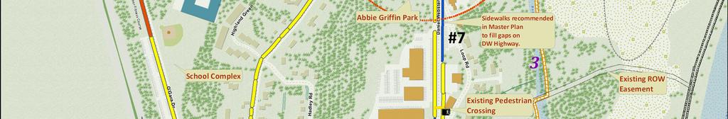
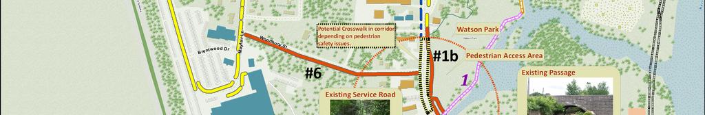
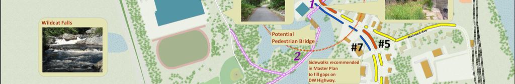
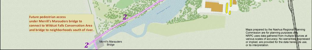
3 EXECUTIVE SUMMARY The recommends that the town take specific actions to achieve a unified and well developed town center. The plan addresses sidewalks, trails, safety, design and parking; all critical elements of a successful town center. A key recommendation is the development of a Town Center Committee to implement the actions identified in this plan. This committee will be responsible for working with administration, town residents and local businesses to enhance the town center by creating a safe and inviting place for town residents and visitors to patronize local businesses and key destinations. The following are prioritized sidewalk and trail improvements. Additional details for each proposed project can be found on pages 6 and 7. The following are recommended actions for the town center. The project completion dates are dependent upon suitable funding and may vary as opportunities present themselves. SIDEWALK MASTER PLAN 1-a. Pedestrian Connections at Abbie Griffin Park to connect the Merrimack District Courthouse to businesses along D.W. Highway. Completion b. Sidewalk in front of Watson Park. Completion West side of D.W. Highway between Church Street and Wire Road. Completion East side of D.W. Highway between Wire Road and Twin Bridge Road. Completion West side of O Gara Drive from Baboosic Lake Road south to existing sidewalk. Completion 2013/ East side of D.W. Highway near Railroad Avenue. Completion South Side of Woodbury Drive from McElwain Street east to D.W. Highway. Completion Sidewalks on both sides of D.W. Highway and Baboosic Lake Road. Completion TRAILS ACTION PLAN 1. Connect Watson Park to the western side of the D. W. Highway near the fire station utilizing the old canal located under the bridge. Completion Develop a trail system along the northerly side of the Souhegan River from the fire station west to join with the trail under the Everett Turnpike at Merrill s Marauders Bridge. The trail will include a connection to the high school facility, to the new pedestrian bridge crossing over the river from West Chamberlain Road, to the system of trails extending into Wildcat Falls, will include the Heritage Trail segment and provide a trail loop along Baboosic Lake Road and D. W. Highway back to Watson Park. Completion Design and construct a trail leaving Watson Park on the old railroad bridge over Baboosic Brook towards the Merrimack River. The trail will turn north and west and connect to the northerly end of the Twin Bridges trail system. Completion
4 2
5 INTRODUCTION Over the past decade the town of Merrimack has spent a considerable amount of effort planning for the future of the town center in the development of the Town Center Plan (1999), the Master Plan Update (2002) and the Merrimack Village Design Charrette (2006), developed by Plan NH. These plans, especially the Town Center Plan, provide a wealth of information about the existing features of the town center as well as a vision for the center s future. However, there are few recommendations in these documents for how to achieve this future vision. This Merrimack Town Center Pedestrian and Trail Master Plan was developed through the Nashua Regional Planning Commission s Integrated Transportation and Community Planning Program, known as itrac. The itrac program assists communities in taking a holistic approach to integrated transportation, land use and environmental considerations through education and technical assistance. This project analyzed the existing town center documents and developed a short list of recommendations with specific items that can be implemented by the town to achieve a unified and well developed town center. The project aims to achieve the following goals: Create a short action plan identifying a series of specific items for implementation in the town center during the development of the Merrimack District Courthouse and redevelopment of the municipal complex. The action items are based upon recommendations identified in the existing Town of Merrimack plans as stated above. Identify existing and future trail and pedestrian connections between key destinations in the town center. Develop a brochure for the public and identify outreach techniques to educate the town about the benefits of a well defined and developed town center. PROJECT SUBCOMMITTEE The formation of the itrac Committee was endorsed by the Merrimack Town Council and was established as a subcommittee of the town s Economic Development Citizen Advisory Committee (EDCAC). The itrac Committee was comprised of a diverse group of individuals and included the following members: Peter Flood, Chair, Economic Development Citizen s Advisory Committee; Representative Chris Christensen, Parks and Recreation Committee; Tracy Bull, School District; Richard Maloon, Watson 3
6 Park; Ellen Knowlton, Library; Nelson Disco, Planning Board; Andy Powell, Conservation Commission; Debra Huffman, Resident; Bill Wilkes, Merrimack Rotary President; Dave Nichols, Heritage Commission; and Linda Bonetti, Economic Development Citizen s Advisory Committee. PROJECT STUDY AREA The project study area includes the town center of Merrimack generally within the boundaries of the Town Center Zoning Overlay District. This includes the Merrimack District Courthouse, municipal buildings, churches, pedestrian connections between the schools, town center amenities, businesses, Merrill s Marauders Bridge, and Wildcat Falls. Please see the Town Center Pedestrian and Trail Master Plan Map at the back of the plan. The following quote is an overall goal listed in the Merrimack Town Center Master Plan Update (2002): Build upon the existing concentration of public facilities, semi-public institutions, historic resources, businesses and residences to create a defined Town Center for Merrimack that will provide a vital, functional and aesthetically pleasing physical expression of Merrimack s cultural, commercial, community and civic life. The Town Center Pedestrian and Trails Master Plan identifies key action items to implement the above goal. The town center is already home to a number of excellent resources and key destinations including public gathering places, recreation sites, municipal buildings, churches, schools, restaurants, and businesses. In particular, the committee identified two pedestrian access areas in the central and southern end of the town center. The two areas are shown with a red dashed circle on the Town Center Pedestrian and Trail Master Plan Map. The first Pedestrian Access area is centrally located at the intersection of Baboosic Lake Road and Daniel Webster Highway (D.W. Highway). This area is home to the municipal complex, Merrimack District Courthouse, library, entrances to schools, churches, Abbie Griffin Park and the Merrimack Community Bandstand, as well as a number of businesses. The goal is to enhance pedestrian amenities such as lighting, street furniture, landscaping, special sidewalk and crosswalk treatments as well as public art in this area to attract additional pedestrian traffic and encourage additional businesses and services. The same is the case for the second pedestrian access area centered at Watson Park along D.W. Highway. Watson Park is anticipated to attract additional pedestrian traffic and create a desirable atmosphere for additional businesses. In recent years new businesses such as Swan Chocolates and Buckley s Great Steaks have located here. 4


7 Another key destination is Kids Kove Playground. This playground is located at Twin Bridge Park and although there are no sidewalks to access the park there is a beautiful trail through the woods running behind the park. The trail exits near the Commons Shopping Plaza and adjacent multi-family housing. This provides an excellent connection for families in this area to travel along an attractive and well maintained trail to the park and adjoining ball fields. The pedestrian foot traffic has the potential to support businesses at the Commons Shopping Plaza, such as a café, ice cream and gift shop. Additional amenities such as seating, landscaping and signage will make this location more appealing to pedestrians. These are just the beginnings of how the town center could evolve and really come to life to form a thriving and diverse center of the community. EXISTING VERSUS DESIRED AMENITIES Merrimack s town center is home to a number of public gathering places, recreation sites, churches, municipal buildings, schools, restaurants, businesses and existing residences. Town residents visit many of these sites on a routine basis, however additional amenities and connections should be made to enhance their pedestrian experience in the town center. Connections between sites need to be enhanced with improved trail and pedestrian connections and amenities to allow people to park at one location and walk to several destinations. The Town Center is continuing to attract new businesses, and in recent years has seen additions such as CVS, Swan Chocolates and Buckley s Great Steaks. These businesses are opportunely located across from Watson Park, all of which are within walking distance of the high school. Special attention should also be paid to current and future town center residents to encourage walking between their homes and other destinations. Additional amenities should also be added to enhance the pedestrian experience, including street furniture, landscaping, public art, attractive lighting, sidewalks, trails, signage, public parking, and bike racks. 5
8 SIDEWALK MASTER PLAN The following is a list of connections as shown on the Town Center Pedestrian and Trail Master Plan Map, listed in priority order. The project completion dates are dependent upon suitable funding and may vary as opportunities present themselves. 1-a. 1-b. Pedestrian Connections at Abbie Griffin Park to connect the Merrimack District Courthouse to businesses along D.W. Highway. (High priority due to current development of Merrimack District Courthouse.) Completion date: 2010 Sidewalk in front of Watson Park (High priority due to planned development of this sidewalk and Watson Park.) Completion date: West side of D.W. Highway between Church Street and Wire Road. (Important connection to facilitate access from the north as well as Twin Bridge Park and Kids Kove Playground.) Completion date: East side of D. W. Highway between Wire Road and Twin Bridge Road (Will facilitate access to the Commons and residential areas at the north end of the town center, however this section is likely to require ROW acquisition, grading, and a needed bridge.) Completion date: West side of O Gara Drive (Requires input from the school district and would impact current parking patterns. Sidewalk would provide an ideal walking loop for pedestrians.) Completion date: East side of D. W. Highway near Railroad Avenue (Small section along Frasier Square at the southern end of the Town Center.) Completion date: South side of Woodbury Drive (Ideal connection between D.W. Highway and the High School. This would require coordination with the School District, re-evaluation of existing traffic patterns, and engineering review.) Completion date: Sidewalks on both side of D.W. Highway and Baboosic Lake Road. (Will complete any missing sidewalk segments.) Completion FUTURE FINANCING In order to extend the network of sidewalks throughout the town center a designated ongoing funding source for sidewalks and trails is needed. The following is a list of potential options for sidewalk and trail revenue sources for consideration by the Council. Explore grant opportunities, such at Transportation Enhancement, (NH DOT) and private foundations for fitness grants. 6
9 Development of a designated Town Center specific fund for sidewalks, trails, and streetscaping which would implement the Town Center Pedestrian and Trail Master Plan. Support the funding of the Road Infrastructure Capital Reserve Fund. Work with the town to incorporate projects into the Capital Improvement Plan. Continue to work with developers to make on-site and off-site improvements, as well as obtain land grants and right-of-way easements as new development opportunities present themselves. New developers should be made aware of the Town Center Pedestrian and Trail Master Plan. Explore the feasibility of Development Impact Fees TRAILS MASTER PLAN The town center and Watson Park in particular, is designated as a central destination for sidewalks and walking and biking trails in the referenced town center documents. Currently several trail segments are being used, not as town-managed trails, but still in use by citizens as they travel on foot throughout this area. Connecting them into a trail network, expanding the system and maintaining them will enhance the accessibility and expand traffic into the town center. The establishment of a Trail Master Plan must take into consideration the following tasks, each listed with a projected completion date. Please refer to the Town Center Pedestrian and Trail Master Plan Map at the beginning of the document for an overview of the trail system. 1. Connect Watson Park to the western side of D. W. Highway near the fire station, utilizing the old canal located underneath the bridge. Completion of this trail segment will not only provide a connection to the extended trail along the river but will also provide pedestrian traffic to and from Watson Park with a means to cross D. W. Highway safely. Completion date: Develop a trail system along the northerly side of the Souhegan River from the fire station west to join with the trail under the Everett Turnpike at Merrill s Marauders Bridge. The trail will include a connection to the high school facility, to the new pedestrian bridge crossing over the river from West Chamberlain Road, to the system of trails extending into Wildcat Falls, and will include the Heritage Trail segment and provide a trail loop along Baboosic Lake Road and D. W. Highway back to Watson Park. Completion date: Design and construct a trail leaving Watson Park on the old railroad bridge over Baboosic Brook towards the Merrimack River. The trail will turn north and west and connect to the northerly end of the Twin Bridges trail system. Completion date: 2014 Portions of the proposed trail system are being studied and will be constructed by joining forces with other organizations already working on this project including the Merrill s Marauders Bridge Committee and the Merrimack Conservation Commission. A substantial portion of the trail system can be completed using volunteer labor from scouting organizations, civic groups and interested citizens. However funds will be needed for some elements of the project. As development continues along the path of the trails, we should solicit their assistance in ensuring a route for 7
10 pedestrian traffic along the designated trail route. Grant funds should be explored at private, state and federal levels. Finally, the establishment of a Town Center fund for use on trails, sidewalks and streetscaping in support of the Town Center Master Plan should be established and funded. As development opportunities arise on the east side of Baboosic Brook, on the Longa Property, it would present an ideal opportunity to expand the trail from Watson Park along Baboosic Brook to the back of Twin Bridge Park. This trail could provide alternative transportation between the town center and future development east of Baboosic Brook. FUTURE FINANCING In addition to sidewalks, a proposed trails network has also been identified to increase pedestrian access in the town center. This effort will be much more successful with a designated funding stream. The following options could be considered: PARKING Explore private foundation grants as well as opportunities at the state and federal level for trails development. Encourage Eagle Scout projects as a means of trail development. Establish an Adopt-A-Trail Program or projects and promote to the Boy/Girl Scouts, businesses, and civic groups. Development of a designated Town Center specific fund for sidewalks, trails and streetscaping which would implement the Town Center Pedestrian and Trail Master Plan. Continue to work with developers to make on-site and off-site improvements as well as obtain land grants and right-of-way easements as new development opportunities present themselves. New developers should be made aware of the Town Center Pedestrian and Trail Master Plan. In order to encourage people to park in a central location and walk to multiple destinations, there needs to be general parking for use by the public. Watson Park will provide about 30 parking spaces, and the municipal complex also has parking. However, these are heavily utilized for business at the Town Hall and the Merrimack District Courthouse. The committee feels that sufficient parking is currently available in the town center. However, it is mostly located at existing public and private entities and the general public may not feel that it is available. One way to address this is to contact these locations and negotiate the use of public parking at certain times of the day or week. For instance the schools, churches and Merrimack Youth Association (town owned) have ample parking areas which may be utilized by the general public with proper permission. The newly formed Town Center Committee would address the following actions: 8
11 SAFETY Contact public and private entities to determine if agreements could be developed to allow for public parking during off-peak hours. If successful, provide signage directing the public to available parking. Many high school students walk along Woodbury Street, which does not currently have sidewalks. In addition, vehicle traffic leaving the high school travels east on Woodbury Street and must make a right turn on D.W. Highway as left turns are restricted. Many vehicles leaving the high school travel east on Woodbury Street, turn left behind Tire Town and exit onto D.W. Highway at CVS. This creates an unsafe travel pattern, but is used to avoid the right turn only from Woodbury Street onto D.W. Highway. Safety concerns should be further analyzed, and existing movement restrictions reviewed to identify potential safety improvements along Woodbury Street and at the intersection of D.W. Highway and Woodbury Street. With the opening of Watson Park, it is anticipated that pedestrian movement will increase in the vicinity of the park with pedestrians desiring to cross D.W. Highway to travel between the park and Swan Chocolates, or to access the high school. However, locating a crosswalk in this area is extremely challenging due to the roadway speed, site distance and a significant curve in the roadway just to the south and therefore is not currently feasible. Research and explore the feasibility of implementing traffic calming measures, such as pedestrian refuge islands, sidewalks and landscaping, or a roundabout as a means to slow traffic, to facilitate the successful location of a crosswalk across D.W. Highway in the vicinity of Watson Park and Woodbury Street. Direct pedestrian crossing north of Watson Park at the CVS crosswalk. Explore the feasibility of closing the Church Street entrance to D.W. Highway to facilitate development of sidewalks and overall safety. OTHER CONSIDERATIONS After Watson Park has opened to the public, pedestrian patterns should be reviewed to determine if any behavior changes or patterns have occurred and any changes or improvements are required. Explore the feasibility of locating an outdoor fitness park along O Gara Drive. Many residents utilize a loop along Baboosic Lake Road, O Gara Drive, and McElwain Street for walking and running. This could be enhanced by locating an outdoor exercise park in an open space along the west side of O Gara Drive. Explore private foundation fitness and health grants as well as opportunities at the state and federal level to plan and build a fitness park. 9
12 DESIGN GUIDELINES The town center is subject to design guidelines in both the Subdivision Regulations and the Town Center Overlay District of the Zoning Ordinance and Building Code. Develop design guidelines for lighting within the town center, in accordance with Planning Board Regulations. The Heritage Commission, Planning Board and Public Services of New Hampshire should be consulted for input on design requirements. Develop a Visual Guide of desired design features for the town center. This could be provided to the planning board, developers and property owners in the planning stage of new construction and redevelopment projects. In the Town Center Overlay District add language about methods to enhance streetscape features in the Pedestrian Access Areas as shown on the Town Center Pedestrian and Trail Master Plan. An enhanced streetscape can help create attractive and inviting locations for pedestrians to utilize in the town center. The following amenities should be considered: public art, benches, landscaping, banners, signage, bicycle racks, and sidewalk and crosswalk treatments. In the Town Center Overlay District add language about unified signage directing visitors, pedestrians and drivers to key destinations and amenities in the town center. Should also consider uniform standards for business signs. Consider the feasibility of moving the former Chamber of Commerce information booth to Watson Park. Coordinate with the local Garden Club about possibly enhancing the existing island at Frasier Square. PUBLIC OUTREACH MATERIALS & METHODS In order to successfully expand the network of sidewalks and trails within the town center, this effort needs to be spearheaded by a specific group. In addition this group will need to solicit support from the general public. It is recommended that the town designate a committee dedicated to furthering the development of a vital town center. Establish a permanent Town Center Committee to spearhead this effort and educate the general public about this on-going effort. Develop and distribute educational materials at public venues and events throughout town including Merrimack cable access, the local paper, the town website, and the Merrimack Expo. A brochure on the benefits and key elements of a successful town center has been developed as part of this project for general distribution and education purposes. Solicit participation and contributions to support and sponsor this initiative from area residents, businesses, and civic organizations. The following are a variety of outreach methods that can be used to help effectively communicate the importance of a well developed and connected town center with board members, elected officials, and the general public. In order to connect with the greatest number of residents it is advisable to implement several different techniques. 10
13 Board/Elected Officials Outreach Materials & Methods Presentations at Town Council and Board Meetings Guidebooks Board training Fact sheets Brochures General Outreach Materials & Methods Press releases Fliers Posters Informational brochures Display boards Partnerships with the Merrimack School District Cable access public service announcements Municipal websites Civic group presentations meeting reminders Police department mobile electronic signs Direct mail When communicating with the general public, it is important to remember that not every resident will prefer to receive information in the same manner. Therefore, a variety of outreach methods will need to be employed. It is beneficial to meet with local officials and opinion leaders before conducting a public outreach campaign to ensure that the most effective strategy is developed. #
Executive Summary Route 30 Corridor Master Plan
 Route Corridor Master Plan Project Overview The Route Corridor Master Plan is a coordinated multimodal transportation and land use plan for the entire stretch of Route through East Whiteland Township,
East Burke Transportation, Safety and Capacity Improvements
 East Burke Transportation, Safety and Capacity Improvements The purpose of this project is to increase mobility and improve safety for pedestrians, cyclists, and motor vehicles along VT Route 114 in the
City of Novi Non-Motorized Master Plan 2011 Executive Summary
 City of Novi Non-Motorized Master Plan 2011 Executive Summary Prepared by: February 28, 2011 Why Plan? Encouraging healthy, active lifestyles through pathway and sidewalk connectivity has been a focus
Corpus Christi Metropolitan Transportation Plan Fiscal Year Introduction:
 Introduction: The Safe, Accountable, Flexible, Efficient Transportation Equity Act: A Legacy for Users (SAFETEA-LU) has continued the efforts started through the Intermodal Surface Transportation Efficiency
Ann Arbor Downtown Street Plan
 1 Ann Arbor Downtown Street Plan Public Workshop #1 We know that. 2 Public right-of-way (streets, sidewalks, and alleys) make up 30% of the total District area of downtown. Streets need to provide mobility
City of Darlington Beautification Report
 City of Darlington Beautification Report Approved by the City of Darlington Beautification Board February 2016 The New Downtown Darlington has seen many changes during the past decade with the rehabilitation
General Plan Circulation Element Update Scoping Meeting April 16, 2014 Santa Ana Senior Center, 424 W. 3rd Street, Santa Ana, CA 92701
 General Plan Circulation Element Update Scoping Meeting April 16, 2014 Santa Ana Senior Center, 424 W. 3rd Street, Santa Ana, CA 92701 Meeting Agenda 1. Purpose of Scoping Meeting 2. Project Overview 3.
Vision: Traditional hamlet with an attractive business/pedestrian friendly main street connected to adjacent walkable neighborhoods
 N D. Focus Area II Vision: Traditional hamlet with an attractive business/pedestrian friendly main street connected to adjacent walkable neighborhoods Transit Road Focus Area II is located in the Hamlet
Solana Beach Comprehensive Active Transportation Strategy (CATS)
") Solana Beach Comprehensive Active Transportation Strategy (CATS) 3.0 Goals & Policies The Solana Beach CATS goals and objectives outlined below were largely drawn from the Solana Beach Circulation Element
Solana Beach Comprehensive Active Transportation Strategy (CATS) 3.0 Goals & Policies The Solana Beach CATS goals and objectives outlined below were largely drawn from the Solana Beach Circulation Element
Exhibit 1 PLANNING COMMISSION AGENDA ITEM
 Exhibit 1 PLANNING COMMISSION AGENDA ITEM Project Name: Grand Junction Circulation Plan Grand Junction Complete Streets Policy Applicant: City of Grand Junction Representative: David Thornton Address:
Bicycle Master Plan Goals, Strategies, and Policies
 Bicycle Master Plan Goals, Strategies, and Policies Mobilizing 5 This chapter outlines the overarching goals, action statements, and action items Long Beach will take in order to achieve its vision of
COUNCIL POLICY NAME: COUNCIL REFERENCE: 06/119 06/377 09/1C 10llC 12/1C INDEX REFERENCE: POLICY BACKGROUND
 COUNCIL POLICY NAME: COUNCIL ADVISORY COMMITTEES - TERMS OF REFERENCE ISSUED: APRIL 3, 2006 AMENDED: NOVEMBER 27, 2006 NOVEMBER 23, 2009 JANUARY 11, 2010 DECEMBER 17, 2012 POLICY COUNCIL REFERENCE: 06/119
Agenda. Overview PRINCE GEORGE S PLAZA METRO AREA PEDESTRIAN PLAN
 PRINCE GEORGE S PLAZA METRO AREA PEDESTRIAN PLAN May 28, 2008 Agenda Welcome and introductions Project overview and issue identification Planning context and strengths Design challenges and initial recommendations
CONNECTIVITY PLAN. Adopted December 5, 2017 City of Virginia Beach
 CONNECTIVITY PLAN Adopted December 5, 2017 City of Virginia Beach CONTENTS 1.0 Background & Purpose... 2 2.0 Existing Inventory & Analysis... 3 ViBe District Existing Walking Conditions... 4 3.0 ViBe District
Section 9. Implementation
 Section 9. Implementation The transportation system is just one of many aspects that must be carefully planned to maintain and enhance the quality of living in Cecil County. The Cecil County Bicycle Plan
Chapter 5 Future Transportation
 Chapter 5 Future Transportation The Future Land Use Plan identifies the desired land use designations. The land uses desired for Crozet depend, in large part, on the success of the transportation system,
TRAVEL PLAN: CENTRAL EUROPEAN UNIVERSITY CAMPUS REDEVELOPMENT PROJECT TRAVEL PLAN. Central European University Campus Redevelopment Project.
 TRAVEL PLAN Central European University Campus Redevelopment Project Page 1 Table of Contents Introduction... 3 Background... 7 Building Users... 7 Transportation in Community Consultation... 7 Summary
Bicycle and Pedestrian Advisory Committee (BPAC) November 21, 2013
 November 21, 2013") Bicycle and Pedestrian Advisory Committee (BPAC) November 21, 2013 OVERALL LAND USE CONCEPT Overall Broadway Valdez District: 95.5 acres (35.1 acres right-of ways + 60.4 acres developable land) Plan Subareas:
Bicycle and Pedestrian Advisory Committee (BPAC) November 21, 2013 OVERALL LAND USE CONCEPT Overall Broadway Valdez District: 95.5 acres (35.1 acres right-of ways + 60.4 acres developable land) Plan Subareas:
NEWMARKET UPHAM S CORNER
 SOUTH STATION Planning Initiative NEWMARKET UPHAM S CORNER COLUMBIA ROAD (P) FOUR CORNERS/GENEVA Working Advisory Group (WAG) Meeting #5 TALBOT AVENUE MORTON STREET BLUE HILL AVE/CUMMINS HWY (P) RIVER
integrated action plan
 public presentation. june 24, 2009. city of portsmouth, nh islington corridor integrated action plan richardson & associates, landscape architects evan haynes, public arts consultant Islington Street Corridor
CHAPTER 3: Vision Statement and Goals
 Davidson Walks & Rolls: Active Transportation Master Plan CHAPTER 3 Contents: Overview Vision Statement Measurable Goals Public Outreach CHAPTER 3: Vision Statement and Goals Overview The vision statement
Tonight is for you. Learn everything you can. Share all your ideas.
 Strathcona Neighbourhood Renewal Draft Concept Design Tonight is for you. Learn everything you can. Share all your ideas. What is Neighbourhood Renewal? Creating a design with you for your neighbourhood.
Chapter VISION, MISSION, AND GOALS AND OBJECTIVES. Vision. Mission. Goals and Objectives CONNECTING COMMUNITIES ACROSS THE ST.
 VISION, MISSION, AND GOALS AND OBJECTIVES Chapter 3 The Plan s vision, mission, and goals and objectives were developed through a series of interactive exercises with the Citizens Advisory Committee (CAC)
EXECUTIVE SUMMARY: TRANSIT-ORIENTED DEVELOPMENT IN SMITHS FALLS, ONTARIO; A COMPARISON BETWEEN TWO SITES
 EECUTIVE SUMMARY: TRANSIT-ORIENTED DEVELOPMENT IN SMITHS FALLS, ONTARIO; A COMPARISON BETWEEN TWO SITES Topic and Purpose In 2007, the Mayor of Ottawa s Task Force on Transportation suggested adding a
Bicycle-Pedestrian Master Plan Update
 Bicycle-Pedestrian Master Plan Update Planning & Zoning Commission November 29, 2017 Overview Project Purpose & Scope Project History Plan Vision & Goals Chapter 5: Making Connections-Beyond the Path Next
BIKE PLAN CONTENTS GATEWAY
 CONTENTS Acknowledgments...vii Great Rivers Greenway District Board of Directors... vii Great Rivers Greenway District Staff... vii Project Consultants... vii Committees... viii Citizens Advisory Committee
CHAPTER 7.0 IMPLEMENTATION
 CHAPTER 7.0 IMPLEMENTATION Achieving the vision of the Better Streets Plan will rely on the ability to effectively fund, build and maintain improvements, and to sustain improvements over time. CHAPTER
Goal 3: Foster an environment of partnerships and collaboration to connect our communities and regions to one another.
 Non-Motorized Transportation Plan (NMTP) Draft Vision, Goal and,, Tri-County Regional Planning Commission (TCRPC) Purpose The purpose of the Tri-County Regional Planning Commission (TCRPC) Non-Motorized
Proposed. City of Grand Junction Complete Streets Policy. Exhibit 10
 Proposed City of Grand Junction Complete Streets Policy Exhibit 10 1 City of Grand Junction Complete Streets Policy Vision: The Complete Streets Vision is to develop a safe, efficient, and reliable travel
City of Elizabeth City Neighborhood Traffic Calming Policy and Guidelines
 City of Elizabeth City Neighborhood Traffic Calming Policy and Guidelines I. Purpose: The City of Elizabeth City is committed to ensure the overall safety and livability of residential neighborhoods. One
City of Charlottesville Bicycle and Pedestrian Master Plan Update
 City of Charlottesville Bicycle and Pedestrian Master Plan Update September 17, 2014 I. Welcome and meeting overview II. Project status update III. Network overview IV. Break-out groups Pedestrian Network
Montco 2040 Implementation Grant Program Award Summary
 Municipality Montco 2040 Implementation Grant Program - 2017 Award Summary Support Downtowns Walk/Bike Montco Name of Project Business Parks Total Project Cost Grant Award Schwenksville Main Street Pedestrian
PRINCE GEORGE S PLAZA METRO AREA PEDESTRIAN PLAN
 PRINCE GEORGE S PLAZA METRO AREA PEDESTRIAN PLAN May 28, 2008 Agenda Welcome and introductions Project overview and issue identification Planning context and strengths Design challenges and initial recommendations
MASTER BICYCLE AND PEDESTRIAN PLAN
 VILLAGE OF NORTHBROOK MASTER BICYCLE AND PEDESTRIAN PLAN DRAFT PLAN OPEN HOUSE May 2, 2018 AGENDA 1. Community Engagement 2. Vision and Goals 3. General Structure of Plan 4. Recommendations Overview 5.
Blue Ribbon Commission Report Recommendations on Pedestrian and Bicycle Infrastructure Improvements
 Recommendations on Pedestrian and Bicycle Infrastructure Improvements July 2017 Plan Development: Our committee consisted of seven individuals appointed by the Mayor and Village Board. Those members included:
Perryville TOD and Greenway Plan
 Perryville TOD and Greenway Plan Greenway Glossary Pathway: A bicycle and pedestrian path separated from motorized vehicular traffic by an open space, barrier or curb. Multi-use paths may be within the
CITY OF COCOA BEACH 2025 COMPREHENSIVE PLAN. Section VIII Mobility Element Goals, Objectives, and Policies
 CITY OF COCOA BEACH 2025 COMPREHENSIVE PLAN Section VIII Mobility Element Goals, Objectives, and Policies Adopted August 6, 2015 by Ordinance No. 1591 VIII MOBILITY ELEMENT Table of Contents Page Number
Austin Avenue Bridges Project. Public Meeting Summary
 Austin Avenue Bridges Project Public Meeting Summary June 29, 2016 Red Table Safety and Connectivity Notes: 1. Would like to see forensic report evaluations 2. What is the lifespan? 3. Extend safety considerations
TOWN OF PORTLAND, CONNECTICUT COMPLETE STREETS POLICY
 TOWN OF PORTLAND, CONNECTICUT COMPLETE STREETS POLICY I. VISION, GOALS & PRINCIPLES VISION To improve the streets of Portland making them safer and more accessible for all users including pedestrians,
CONNECTING PEOPLE TO PLACES
 CONNECTING PEOPLE TO PLACES 82 EAST BENCH MASTER PLAN 07 Introduction The East Bench transportation system is a collection of slow moving, treelined residential streets and major arteries that are the
EXECUTIVE SUMMARY. Vision
 Vision Walking and bicycling in Salt Lake City will be safe, convenient, comfortable, and viable transportation options that connect people to places, foster recreational and economic development opportunities,
7 Complete Streets & Roadway Aesthetics
 7 Complete Streets & Roadway Aesthetics 7.1 OVERVIEW Our streets lay the foundation for how we interface with travel needs, physical exercise, social exchanges and access to goods and services. They are
Chapter 3: Multi-Modal Circulation and Streetscapes
 CHAPTER 3: MULTI-MODAL CIRCULATION AND STREETSCAPES Chapter 3: Multi-Modal Circulation and Streetscapes Overview Streetscape improvements have already been completed for Depot Street between Main Avenue
Vision. Goals and Objectives. Walking
 Vision Walking and biking is an accepted and valued part of everyday life in Portsmouth. People of all ages and abilities include walking and biking as part of their daily activities which helps to make
Ocean Park Boulevard Green Street Project Alternatives & Trade Offs
 Planning Commission March 4, 2009 Ocean Park Boulevard Green Street Project Alternatives & Trade Offs Purpose of Tonight s Meeting Review concept plans and options Provide input on alternatives and trade-offs
Item to be Addressed Checklist Consideration YES NO N/A Required Description Complete Streets Guidelines
 Passaic County Complete Streets Checklist - Concept Development Project Name Item to be Addressed Checklist Consideration YES NO N/A Required Description Complete Streets Guidelines Existing Plans Have
WELCOME. Thank you for joining us at the Second Public Workshop for the Carlsbad Pedestrian Master Plan. We look forward to receiving your feedback.
 City of Carlsbad Pedestrian Master Plan: WELCOME WELCOME Please Sign In Provide Input at Flip Charts Review Boards Presentation of Draft Plan Thank you for joining us at the Second Public Workshop for
Bikeway action plan. Bicycle Friendly Community Workshop March 5, 2007 Rochester, MN
 Bikeway action plan Summary The was held on March 5, 2007 at the Rochester Mayo Civic Center. The workshop was hosted by Rochester-Olmsted County Planning Department in collaboration with the League of
CITY OF BLOOMINGTON COMPLETE STREETS POLICY
 CITY OF BLOOMINGTON COMPLETE STREETS POLICY POLICY OBJECTIVE: The City of Bloomington will enhance safety, mobility, accessibility and convenience for transportation network users of all ages and abilities,
Elon Bicycle, Pedestrian and Lighting Plan. Pedestrian Rail Crossings Study
 Elon Bicycle, Pedestrian and Lighting Plan Pedestrian Rail Crossings Study Project Overview The Town of Elon, Elon University and the Twin Lakes Retirement Community began a comprehensive bicycle, pedestrian
TABLE OF CONTENTS. Executive Summary
 Executive Summary Background... ES-1 Pedestrian Network... ES-2 Bikeway Network... ES-2 Collision History... ES-2 Public Input... ES-4 Conclusions and Recommendations... ES-4 1. Introduction and Setting
Bicycle and Pedestrian Chapter TPP Update Overview. TAB September 20, 2017
 Bicycle and Pedestrian Chapter TPP Update Overview TAB September 20, 2017 Bicycling & Walking in the Twin Cities Where are we now? The Bike-Pedestrian system Current trends New developments Where are we
NM-POLICY 1: Improve service levels, participation, and options for non-motorized transportation modes throughout the County.
 Transportation PRINCE WILLIAM COUNTY 2008 COMPREHENSIVE PLAN NON-MOTORIZED PLAN CONTENTS Goals, Policies, and Action Strategies Table 4 (Bike Facility Classifications and Descriptions) Table 5 (Bike Facility
PEDESTRIAN ACTION PLAN
 ATTACHMENT 2 CITY OF SANTA MONICA PEDESTRIAN ACTION PLAN CITY OF SANTA MONICA PEDESTRIAN ACTION PLAN This page intentionally left blank EXECUTIVE SUMMARY CHAPTER 1 EXECUTIVE SUMMARY Setting the Stage
A CHANGING CITY. of Edmonton, it is essential that it reflects the long-term vision of the City.
 A CHANGING CITY By the year 2040, Edmonton will be home to more than 1 million people. To accommodate growth and support a healthy and compact city, we need a new approach to development/redevelopment
1.0 EXECUTIVE SUMMARY
 1.0 EXECUTIVE SUMMARY The Active Transportation Plan is a guide to accomplish the Town s vision for developing a network of sidewalks, on-road bicycle facilities, and trails that allow for safe and convenient
This page intentionally left blank.
 This page intentionally left blank. COMMUNITY Coweta Community Overview Coweta Coweta, a residential community located in Wagoner County, is a suburb of Tulsa situated southeast of the metropolitan area
Summary: Mercer County Princeton Avenue & Spruce Street Study January 2009
 Summary: Several recent studies have assessed potential development and redevelopment opportunities in the Mercer Crossing area of Trenton, Ewing, and Lawrence. This Princeton Avenue and Spruce Street
Montgomery County Life Sciences Center Loop Trail
 Montgomery County Life Sciences Center Loop Trail Advisory Committee Meeting #1 February 10, 2015 Agenda 1. Project Background 2. Existing Conditions Analysis 3. Examples from Elsewhere 4. Discussion Project
This page intentionally left blank.
 This page intentionally left blank. COMMUNITY Glenpool Community Overview Glenpool Glenpool is a city of nearly 12,000 residents located in Tulsa County southwest of Tulsa and Jenks. The city is growing
HOOPA DESIGN FAIR 4. IMPLEMENTATION PHASES & FUNDING
 4. IMPLEMENTATION PHASES & FUNDING HOOPA DESIGN FAIR 4-1 4. IMPLEMENTATION PHASES & FUNDING Phase One Development 1. Implementation The Conceptual Plan recommends five concept elements to revitalize downtown
Eastern PA Trail Summit October 1, 2018
 Eastern PA Trail Summit October 1, 2018 WHO WE ARE + WHY + WE RE * HERE * * * * * * Session Goals: Discuss how to coordinate planning and design in small, urbanized towns Consider how to develop alternative
Congestion Management Report
 Congestion Management Report DANIEL WEBSTER HIGHWAY, MERRIMACK Segment Length: 9.9 miles Daily Traffic Volumes: 13,000-21,000 Analysis Period: July August 2015 Number of Traffic Signals: 14 Number of travel
Chapter 2. Bellingham Bicycle Master Plan Chapter 2: Policies and Actions
 Chapter 2 Bellingham Bicycle Master Plan Chapter 2: Policies and Actions Chapter 2: Policies and Actions The Bicycle Master Plan provides a road map for making bicycling in Bellingham a viable transportation
Active Transportation Infrastructure Investment A Business Case
 Active Transportation Infrastructure Investment A Business Case In 2016, the Real Estate Foundation awarded the Capital Regional District a $50,000 grant for Shifting Gears: Land Use Change through Active
Comments The Plan for Port Whitby
 Comments The Plan for Port Whitby April 24th, 2013 Community Meeting #2 Summary Report Prepared by GLPi April 29th, 2013 1 Introduction The purpose of the Port Whitby Secondary Plan Update, Community Improvement
DRAFT. Table of Contents. Background
 Douglas County Table of Contents Existing Infrastructure 86 Funding 89 Policy and Program Recommendations 90 Infrastructure Recommendations 92 Conclusion 95 Background Home to 4,500 residents and Baker
Sandwich Pedestrian/Bicycle Planning
 Sandwich Pedestrian/Bicycle Planning Improved Pedestrian and Bicycle Connections with the Cape Cod Canal Multi-use Path February 2014 Table of Contents Introduction... 1 Background... 1 Study Goals...
II. EXISTING NEIGHBORHOODS
 TABLE OF CONTENTS Page I. INTRODUCTION Purpose... 1-1 How To Use This Document... 1-1 Goals and Objectives....... 1-2 History of the Policy.... 1-3 For Further Assistance... 1-6 Policy Revisions......
FOCUS AREA 1 - Alberta Avenue Pocket Park 3 (121 Ave and 92 St)
") FOCUS AREA 1 - Alberta Avenue Pocket Park 3 (121 Ave and 92 St) New benches Plant evergreen trees Widen existing sidewalk from 1.5m to 1.8m Marked crosswalk 1.8m wide sidewalk Add pedestrian oriented lights
FOCUS AREA 1 - Alberta Avenue Pocket Park 3 (121 Ave and 92 St) New benches Plant evergreen trees Widen existing sidewalk from 1.5m to 1.8m Marked crosswalk 1.8m wide sidewalk Add pedestrian oriented lights
Plant City Walk-Bike Plan
 Plant City Walk-Bike Plan Plant City Commute Mode Share 2.2% 1.4% 2.9% Drove alone 10.2% Carpooled Public transportation (0.1%) Walked Used a Bike (0.4%) 82.9% Taxicab, motorcycle, or other means Worked
o n - m o t o r i z e d transportation is an overlooked element that can greatly enhance the overall quality of life for the community s residents.
 N o n - m o t o r i z e d transportation is an overlooked element that can greatly enhance the overall quality of life for the community s residents. 84 Transportation CHAPTER 11 INTRODUCTION Transportation
WELCOME. Purpose of the Open House. Update you on the project. Present a draft recommended plan. Receive your input
 WELCOME Purpose of the Open House The Town of Smiths Falls has initiated the Beckwith Street Redevelopment Plan that includes the preparation of a streetscape functional design for the renewal of Beckwith
MAG Town of Cave Creek Bike Study Task 6 Executive Summary and Regional Significance Report
 Page 1 MAG Town of Cave Creek Bike Study Task 6 Executive Summary and Regional Significance Report August 1, 2012 MAG Project #481 Page 2 Task 6 Executive Summary and Regional Significance Report Introduction
Table of Contents Introduction. 2 Purpose of the Plan...2 The Benefits of Walking and Bicycling...3 Vision and Goals of the Plan...
 BICYCLE AND This plan was created through a grant from the Healthy Communities Program with the cooperation of the City of Cynthiana, Cynthiana Main Street, Cynthiana-Harrison County-Berry Joint Planning
5 Circulation & Parking
 5 Circulation & Parking Downtown Parking & Circulation Strategy. Downtown Wayne has a somewhat disconnected system of local public streets to connect downtown with the residential neighborhoods, and primary
CITY OF PORTSMOUTH PLANNING DEPARTMENT
 CITY OF PORTSMOUTH PLANNING DEPARTMENT MEMORANDUM TO: JOHN P. BOHENKO, CITY MANAGER FROM: JULIET T.H. WALKER, PLANNING DIRECTOR SUBJECT: BICYCLE / PEDESTRIAN PLAN PROGRESS UPDATE DATE: 3/13/2018 Background
Figure 4-10: Pedestrian Improvements Types of Potential Station Area Improvements - Place-Making Improvements
 INCORPORATE FEATURE PAVIN IN CROSSWALK AND INTERSECTION FIELDS Identifies high-priority pedestrian areas and create a station identity through colorful and interesting patterns ADD CURB EXTENSIONS Extending
CITY OF SAINT JOHN TRAFFIC CALMING POLICY
 CITY OF SAINT JOHN TRAFFIC CALMING POLICY VERSION: 1.0 April 10, 2012 Pedestrians, Cyclists and Motorists Sharing Street Spaces CONTENTS INTRODUCTION... 3 POLICY GOAL... 3 POLICY OBJECTIVES... 3 GUIDING
Non-Motorized Transportation 7-1
 Non-Motorized Transportation 7-1 Transportation facilities no longer mean just accommodating a vehicle powered by a combustion engine. Pedestrian and non-motorized facilities are important modes of travel
APPENDIX A: Complete Streets Checklist DRAFT NOVEMBER 2016
 APPENDIX A: Complete Streets Checklist DRAFT NOVEMBER 2016 Complete Streets Checklist MetroPlan Orlando s Complete Streets Checklist is an internal planning tool for staff to further implementation of
City of Wilsonville 5 th Street to Kinsman Road Extension Project
 City of Wilsonville 5 th Street to Kinsman Road Walking Tour & Neighborhood Workshop Summary Report Public Outreach Overview On July 18 th, 2017, the City of Wilsonville hosted a neighborhood walking tour
University of Victoria Campus Cycling Plan Terms of Reference. 1.0 Project Description
 University of Victoria Campus Cycling Plan Terms of Reference 1.0 Project Description The Campus Cycling Plan, a first for the University, will provide a comprehensive and coordinated approach to support
Shifting Gears for a Healthier City
 Shifting Gears for a Healthier City Mississauga s Cycling Master Plan is an ambitious strategy that sets out to transform Mississauga into a city that is conducive to cycling for daily transportation needs.
NOTICE OF AVAILABILITY/NOTICE OF COMMENT PERIOD OF A DRAFT EIR/EIS/EIS FOR PUBLIC REVIEW AND HEARINGS
 Tahoe Transportation District 128 Market Street, Suite 3F Stateline, NV 89449 Phone: (775) 589-5500 www.tahoetransportation.org Federal Highway Administration 650 Capitol Mall, Suite 4-100 Sacramento,
 Phasing and Cost Estimate of Downtown Oxford Master Plan Prepared By: Phasing and Cost Estimate of Downtown Oxford Master Plan Purpose of the Study The primary objective of this study is to identify priority
Cross Street Corridor Non-Motorized Enhancement Project Project Description
 Cross Street Corridor Non-Motorized Enhancement Project Project Description A cooperative study of the Cross Street neighborhood was completed in May 2002 by the City of Ypsilanti, the Depot Town Downtown
IMPLEMENTATION STRATEGIES
 GEORGETOWN SIDEWALK MASTER PLAN 34% of funding is dedicated to Downtown Overlay District sidewalks 28% of funding is recommended within 1/4 mile of Southwestern University 26% of funding is recommended
In station areas, new pedestrian links can increase network connectivity and provide direct access to stations.
 The Last Mile Planning for Pedestrians Planning around stations will put pedestrians first. Making walking to stations safe and easy is important; walking will be a part of every rapid transit Accessible
Town of Orangetown Neighborhood Traffic Calming Program
 Town of Orangetown Neighborhood Traffic Calming Program Table of Contents I Introduction a. Purpose b. Key to successful projects c. What is Traffic Calming? II III IV V VI VII Definitions Street Classification
BETHEL ROAD AND SEDGWICK ROAD CORRIDOR STUDY
 DRAFT PLAN City Council Meeting August 14, 2017 STUDY AREA Sedgwick Corridor State Route 160, principal arterial with Class 3 access management designation, commuter and freight route, connection to SR
Residential Traffic Calming Program Guide. Town of Ashland, Virginia
 Residential Traffic Calming Program Guide Town of Ashland, Virginia August 1, 2006 TABLE OF CONTENTS A. INTRODUCTION... 1 B. GOALS... 1 C. CRITERIA... 1 D. IDENTIFYING NEIGHBORHOOD TRAFFIC CONCERNS...
 Time of Change We Are Growing We Are An Attractive Place To Live We Are Age Diverse + Living Longer 50000 40000 30000 20000 10000 0 2010 Census Job Density Housing Sheds Transit Sheds The Project FUNDING
Traffic Improvements for the Transit Oriented Development District (TODD) Meriden Public Library March 11, 2014
 Meriden Public Library March 11, 2014") Traffic Improvements for the Transit Oriented Development District (TODD) Meriden Public Library March 11, 2014 Project Overview Coordinate roadway improvements with other major projects HUB Flood Control
Traffic Improvements for the Transit Oriented Development District (TODD) Meriden Public Library March 11, 2014 Project Overview Coordinate roadway improvements with other major projects HUB Flood Control
Chapter 7. Transportation. Transportation Road Network Plan Transit Cyclists Pedestrians Multi-Use and Equestrian Trails
 Chapter 7 Transportation Transportation Road Network Plan Transit Cyclists Pedestrians Multi-Use and Equestrian Trails 7.1 TRANSPORTATION BACKGROUND The District of Maple Ridge faces a number of unique
TRAFFIC ACTION PLAN. Laurie Meadows Neighborhood CITY OF SAN MATEO
 TRAFFIC ACTION PLAN Laurie Meadows Neighborhood CITY OF SAN MATEO Draft January 2017 Table of Contents Introduction... 2 The Traffic Forum Process... 5 Neighborhood Traffic Issues... 7 Neighborhood Recommendations
Table #6 VISION CHARACTERISTICS
 Table #6 VISION White Flint is a place to live, work, play, shop, and walk with sufficient density to encourage quality redevelopment. Vibrant streets and consistent streetscapes are important. CHARACTERISTICS
A Complete Streets Policy for Saratoga Springs. Presented By: Shared Access Saratoga
 A Complete Streets Policy for Saratoga Springs Presented By: Shared Access Saratoga April 17, 2012 Agenda 1. Introduction to Complete Streets (CS) 2. Shared Access Saratoga 3. Why is CS Important 4. What
DOWNTOWN TENINO. Goal: Get more People in Downtown. A Pamphlet of Concepts for
 A Pamphlet of Concepts for DOWNTOWN TENINO The Tenino Planning Commission believes that the highest potential for economic development and business development in the City of Tenino (in the short-term)
MONTCLAIR SAFE COMPLETE STREETS IMPLEMENTATION PLAN. Monday November 13, 2017 Michael Dannemiller, Principal Engineer NV5, Inc.
 MONTCLAIR SAFE COMPLETE STREETS IMPLEMENTATION PLAN Monday November 13, 2017 Michael Dannemiller, Principal Engineer NV5, Inc. PROJECT TEAM THE OFFICE OF BICYCLE AND PEDESTRIAN PROGRAMS, NEW JERSEY DEPARTMENT