Let s Make I-40 Better Action Team. Friday, March 29, 2019 Hosted by RTP Foundation
|
|
|
- Laurel Lamb
- 5 years ago
- Views:
Transcription
1 Let s Make I-40 Better Action Team Friday, March 29, 2019 Hosted by RTP Foundation
2 RTA Welcome Geoff Lang, MetLife, RTA Chair Jim Beley, The Umstead Hotel & Spa, RTA regional travel experience chair
3 NCDOT Welcome Meredith McDiarmid, NCDOT I-40 Regional Partnership Executive
4 Host Welcome Tim Brock Research Triangle Foundation
5 Action Team Objectives Joe Milazzo II, RTA
6 Action Team and Meeting Objectives Understand current and expected operation and planned projects for I-40 and vicinity Generate ideas for: accelerating or improving existing plans advancing a smaller piece of a proposed project new low-cost improvements Identify action we can take to implement or explore at least one new approach
7 Current and Expected Status of I-40 Dr. Joe Hummer NCDOT Mobility & Safety
8 Current and Expected I-40 Status Joe Hummer, PhD, PE State Traffic Management Engineer For RTA I-40 Action Team, March 29, 2019

9 Particularly Between NC-147 and I-540 It s important It s bad How bad is it? It s going to get worse How much worse? Constraints Opportunities

10 NC s Main Street Besides NC-147, the only freeway connection between I-85 and I-95 in NC
11 Geometry 4 lanes, lanes plus aux., lanes plus aux., lanes plus aux., 2500

12 Left entrance at NC-147 Interchanges Otherwise ¾-cloverleaf is OK Parclo ABs at Davis, Miami, and Page Not terrible designs Weaknesses include lane utilization, unusual maneuvers, and poor signal progression They are working pretty well

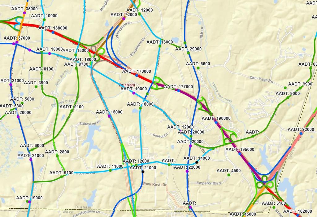
13 2017 AADTs

14 Travel Time, 7:40 AM From Google, typical traffic

15 Travel Time, 3:35 PM

16 Travel Time, 4:25 PM

17 Travel Time, 5:30 PM
18 HERE probe data NC-55 to Airport Boulevard Travel Time January and February 2019 Tuesday-Thursday Direction Free-flow travel time, min Average speed, mph 5-6 pm Average travel time, min Planning time, min Westbound Eastbound


19 Compare to Other Corridors Usual Top 10 among NC non-work zone freeway bottlenecks December 2018 ranked 10 th January 2019 ranked 7 th Vies with EB I-540 as worst in Division 5
20 Reported Crashes 1471 reported crashes in recent five years NC-147 bridge to I-540 bridge Crash rate per 100 million vm = 139 Compare to statewide urban interstate rate = 130 Fatal and injury rates also near statewide average 64% of crashes rear-end 44% of crashes 5 pm to 7 pm Only 9% of crashes Saturday and Sunday Over 90% of involved were light vehicles
21 400 Reported Crashes Volume growing just over 2% per year, crashes growing over 10% per year
22 It s a Local Commuter Problem Street Light data from DCHC MPO PM peak hour, eastbound Of traffic on I-40 approaching I % from I-40 west of NC % from NC % from Davis 13% from Miami 21% from Page
23 AADT Growth Year 1% 1.5% 2.1% , , , , , , , , , , , , , , , , , , , , , , , , , , , , , , ,000
24 2045 Daily V/C From DCHC MPO

25 Bridges Constraints No room underneath Railroad No frontage roads Left entrance Weaves Need express lane configuration if widened?

26 Right of way NC-147 interchange Along I-40 Parallel routes NC-54 NC-147 to NC-540 $1.68 and two extra miles Opportunities US-70 as freeway US-421 to US-64 to Southern Outer Loop
27 It s important It s bad Summary Congestion, safety Not nearly the worst in the state PM peak, commuters, light vehicles, mainline Expected to get much worse In 2045 AADT of 340,000? V/C of 1.4? Constraints and opportunities

28 Thank You! Let s go fix some intersections and interchanges Joe Hummer , jehummer@ncdot.gov
29 Ongoing and upcoming improvements on I-40 and vicinity Alex Rickard Capital Area MPO
30 MPO/NCDOT Projects for I-40 Short Term ( ) Mid-Term ( ) Long-Term (Beyond 2030) Other Planning Studies & Initiatives

31 Near Term ( ) I-40 Projects Interchange Projects: I-5700 Airport Blvd I-5506 Aviation Pkwy Auxiliary Lanes: I-5707 NC 55 to NC 147 (WB only) I-540 to Aviation Pkwy Parallel Routes East End Connector US 70 U Expressway NC 54 U Widening Aviation Parkway U-5811 McCrimmon Ave U-5828, U- 5747

32 Mid-Term ( ) I-40 Projects Widening I-5701 I-440 to Lake Wheeler Interchange Improvements I-5703 I-40/I-440/US1 Auxiliary Lanes I-5966 Aviation to Harrison Ave Managed Motorways I-6006 NC 147 to Wade Ave Parallel Routes US 70 U-5720 Expressway US 70 U-2823 Superstreet I-440 / US 70 I Interchange NC 147 U-5937 Operational Impvs NC 147 U Widening NC 147 U-5966 New location US 64 U Expressway Wade Ave U Widening

33 Long-Term (beyond 2030) I-40 / I-440/US1/I-87 Managed Motorways U-6101 I-40 Managed Lanes NC 54 Widening/Superstreet I-540 Managed Motorways & Managed Shoulders
34 Other Planning Studies & Initiatives Triangle Regional Tolling Study Triangle Regional ITS Plan Update Commuting Corridors Study Traffic Incident Management Program
35 Questions Alex Rickard, Capital Area MPO Aaron Cain, Durham Chapel-Hill Carrboro MPO David Keilson, NCDOT Division 5
36 I-40 on-ramp signals / managed freeway study Mike Surasky, WSP
37 I-25 Corridor in Colorado Being developed as part of Colorado DOT s RoadX program Currently under construction including ramp modifications, upgraded traffic detection, and back office changes. First deployment of Australian type of Managed Motorways in the US. Metering will also be deployed on system to system (freeway to freeway) interchanges. Management of the system will be cloud based to allow use of the STREAMS freeway management system. Providing a lot of lessons learned for NC

38 I-40 in Triangle Region Wade to NC 54 Feasibility study under way, completion by June Preliminary screening Analysis of required storage Analysis of Ramp Discharge Capacity Detection requirements, including detection templates for various interchange types High level cost estimates and environmental analysis Have completed traffic counts and analyzed ramp capacities, bottlenecks, and detection requirements Working with NCDOT on software/it concerns Beginning to develop ramp designs
39 TABLE DISCUSSION
40 Discussion prompts How might an existing project be improved/enhanced? What piece of an existing project might be separated and accelerated? What is something of little to no cost that might help (and wouldn t have to go through STI)?
41 GROUP DISCUSSION
I-264 CORRIDOR EVALUATION STUDY. September 7, 2016 Eric Stringfield VDOT Planning Director Chris Lawrence AECOM Senior Transportation Engineer
 I-264 CORRIDOR EVALUATION STUDY September 7, 2016 Eric Stringfield VDOT Planning Director Chris Lawrence AECOM Senior Transportation Engineer Study Overview Interchange Locations Study Context Follow-up
Northwest Corridor Project Interchange Modification, Interchange Justification and System Analysis Report Reassessment (Phase I)
") Northwest Corridor Project Interchange Modification, Interchange Justification and System Analysis Report Reassessment (Phase I) Introduction The Georgia Department of Transportation (GDOT) prepared a
Northwest Corridor Project Interchange Modification, Interchange Justification and System Analysis Report Reassessment (Phase I) Introduction The Georgia Department of Transportation (GDOT) prepared a
FM #: ETDM #: 11241
 SR 826/Palmetto Expressway PD&E Study From SR 93/I 75 to the Golden Glades Interchange FM #: 418423 1 22 01 ETDM #: 11241 Agency/ Kick Off Meeting October 27, 2011 2 Location Map From SR 93/I 75 to Golden
7.0 FREEWAYS CONGESTION HOT SPOT PROBLEM & IMPROVEMENT PROJECT ANALYSIS & DEFINITION
 7.0 FREEWAYS CONGESTION HOT SPOT PROBLEM & IMPROVEMENT PROJECT ANALYSIS & DEFINITION 7.1 INTRODUCTION & METHODOLOGY FEASIBILITY REPORT Congestion hot spot problem locations have been assessed using the
MORRISVILLE TRANSPORTATION PLAN TOWN COUNCIL WORK SESSION AUGUST 8, 2017
 TOWN COUNCIL WORK SESSION AUGUST 8, 2017 ENGAGEMENT SUMMARY OPEN HOUSE #2 OPEN HOUSE #2 31 ATTENDEES! TRANSPORTATION RECOMMENDATIONS 2040 E+C MODELED CONGESTION Committed Projects Aviation Parkway Widening
Chapter 4 Traffic Analysis
 Chapter 4 Traffic Analysis PURPOSE The traffic analysis component of the K-68 Corridor Management Plan incorporates information on the existing transportation network, such as traffic volumes and intersection
Highway 49, Highway 351 and Highway 91 Improvements Feasibility Study Craighead County
 Highway 49, Highway 351 and Highway 91 Improvements Feasibility Study Craighead County Executive Summary March 2015 Highway 49, Highway 351 and Highway 91 Improvements Feasibility Study Craighead County
I-95 NORTHBOUND AT US 1 (EXIT 126) ALTERNATIVES DESIGN ANALYSIS
 ALTERNATIVES DESIGN ANALYSIS") FAMPO Policy Committee Briefing June 18, 2018 I-95 NORTHBOUND AT US 1 (EXIT 126) ALTERNATIVES DESIGN ANALYSIS WHAT IS THE STARS PROGRAM? Program to develop solutions to reduce crashes and congestion bottlenecks
FAMPO Policy Committee Briefing June 18, 2018 I-95 NORTHBOUND AT US 1 (EXIT 126) ALTERNATIVES DESIGN ANALYSIS WHAT IS THE STARS PROGRAM? Program to develop solutions to reduce crashes and congestion bottlenecks
MoPac South: Impact on Cesar Chavez Street and the Downtown Network
 MoPac South: Impact on Cesar Chavez Street and the Downtown Network Prepared by: The University of Texas at Austin Center for Transportation Research Prepared for: Central Texas Regional Mobility Authority
Mid Rivers Mall Drive/I-70 & Route 79/I-70 Interchange Study
 Mid Rivers Mall Drive/I-70 & Route 79/I-70 Interchange Study Prepared for: City of St. Peters One St. Peters Center Boulevard St. Peters, Missouri 63376 TABLE OF CONTENTS Introduction... 5 Study Area...
Feasibility Study of Pedestrian Crossings Along Route 7, East of Cascades Parkway and West of Dranesville Road. October 3, 2017
 Feasibility Study of Pedestrian Crossings Along Route 7, East of Cascades Parkway and West of Dranesville Road October 3, 2017 Study Area (area within a ¼-mile radius of the study intersections) Route
I-95 Northbound at US 1 (Exit 126) Design and Study Final Report
 Design and Study Final Report") I-95 Northbound at US 1 (Exit 126) Design and Study Final Report July 2018 Prepared by: Prepared for: TABLE OF CONTENTS 1 Introduction... 1 Study Area Limits... 1 Purpose and Need of the Study... 1 Safety
I-95 Northbound at US 1 (Exit 126) Design and Study Final Report July 2018 Prepared by: Prepared for: TABLE OF CONTENTS 1 Introduction... 1 Study Area Limits... 1 Purpose and Need of the Study... 1 Safety
Toll Express Lanes for the Research Triangle region Including discussion of possible applications on I-40
 Toll Express Lanes for the Research Triangle region Including discussion of possible applications on I-40 Presentation for discussion at Durham-Chapel Hill-Carrboro MPO TAC meeting Wednesday, December
Offset Single Point Interchange I-25 at Rio Bravo Boulevard Albuquerque, New Mexico
 Offset Single Point Interchange I-25 at Rio Bravo Boulevard Albuquerque, New Mexico INSTITUTE OF TRANSPORTATION ENGINEERS 2016 WESTERN DISTRICT MEETING JULY 11, 2016 7/11/2016 1 Project Vicinity Map 7/11/2016
PRELIMINARY DRAFT WADDLE ROAD / I-99 INTERCHANGE PROJECT ALTERNATIVE ANALYSIS FINAL TRAFFIC SUMMARY REPORT
 PRELIMINARY DRAFT WADDLE ROAD / I-99 INTERCHANGE PROJECT ALTERNATIVE ANALYSIS FINAL TRAFFIC SUMMARY REPORT Prepared by: In Association with: November 2013 EXECUTIVE SUMMARY Patton Township, in partnership
Maryland State Highway Mobility Report. Morteza Tadayon
 Maryland State Highway Mobility Report Morteza Tadayon Background Mobility is a Key Performance Area (KPA) in the SHA Business Plan SHA adopts a performance based approach Monitors Highway System to identify
CHAPTER 3 STUDY AREA OPERATIONAL OVERVIEW
 HPTER 3 STUY RE OPERTIONL OVERVIEW This chapter describes the overall traffic operations within the study area under existing and future conditions and focuses on individual intersections not directly
TECHNICAL MEMORANDUM
 TECHNICAL MEMORANDUM DATE: January 17, 2005 TO: Ted Idlof, URS FROM: Jeff Clark, Fehr & Peers RE: U.S. 50 Interchange Planning Study 1042-2011 This memorandum describes conceptual improvements for the
7.0 Preferred Alternative with Service Road Concept
 .0 Preferred Alternative with Service Road Concept This section evaluates the traffic operations for all of the study years for the Build conditions as related to the Preferred Alternative with Service
Proposed Project I 35 from Denton to Cooke County Line
 Proposed Project I 35 from Denton to Cooke County Line The existing I 35 facility is four lanes from I 35E/I 35W to Farm to Market Road (FM) 3002. The purpose of the proposed project is to increase capacity
Terwillegar Drive Expressway Draft Concept Plan
 Terwillegar Drive Expressway Draft Concept Plan Anthony Henday Drive to Whitemud Drive November 28 5:00-8:00 p.m. December 1 10:00 a.m. - 3:00 p.m. Let s Talk Today you can: Learn about the new direction
Interstate Route 77 / US Route 62 / State Route 687 (Fulton Road) Transportation Improvement Project. Prepared September 6, 2017
 Transportation Improvement Project. Prepared September 6, 2017") EODOT Project: ODOT Project: STA-IR 77-.50; PID 00290 Interstate Route 77 / US Route 62 / State Route 687 (Fulton Road) Transportation Improvement Project Summary of Public Comments Received and Responses
EODOT Project: ODOT Project: STA-IR 77-.50; PID 00290 Interstate Route 77 / US Route 62 / State Route 687 (Fulton Road) Transportation Improvement Project Summary of Public Comments Received and Responses
Harrah s Station Square Casino
 Transportation Analysis Harrah s Station Square Casino Pittsburgh, Pennsylvania Submitted To: City of Pittsburgh and Pennsylvania Gaming Control Board Prepared By: DKS Associates GAI Consultants December
Operational & Geometrical Analysis Technical Memorandum
 I-395 Southbound between Duke Street & Edsall Road: Congestion Relief Feasibility Study Operational & Geometrical Analysis Technical Memorandum Task Order #92 Prepared by: July 17, 2012 Rummel, Klepper
Gwinnett County Department of Transportation SR 324 / Gravel Springs Road at I-85 / SR 403 Interchange Project Number F , PI No.
 June 4, 2015 Dear Resident: Thank you for attending this public information meeting for the proposed SR 324 / Gravel Springs Road at I-85 Interchange. The purpose of this meeting is two-fold: to provide
RTA Solutions Forum 13
 RTA Solutions Forum 13 We recognize that more extensive study and expensive solutions often required Solutions Forum seeks to identify smaller improvements that can be implemented quickly and at lower
SH-6 Corridor Improvement Study Policy Committee Progress Report M O N D AY, J U N E 1 0, B R A Z O S C E N T E R
 SH-6 Corridor Improvement Study Policy Committee Progress Report M O N D AY, J U N E 1 0, 2 0 1 3 B R A Z O S C E N T E R Project Overview Study Goals and Objectives» Improve traffic flow» Reduce delay»
JONESBORO HIGHWAY 63 HIGHWAY 18 CONNECTOR STUDY
 JONESBORO HIGHWAY 63 HIGHWAY 18 CONNECTOR STUDY Craighead County May 2007 JONESBORO HIGHWAY 63 HIGHWAY 18 CONNECTOR STUDY Craighead County May 2007 Prepared by Planning and Research Division Arkansas State
Please find below the Town staff s responses to NCDOT s recommended roadway stipulations listed in a letter dated May 25, 2015.
 TOWN OF CHAPEL HILL Public Works Department 6850 Millhouse Road Chapel Hill, NC 27516-8173 phone (919) 969-5100 fax (919) 969-2003 www.townofchapelhill.org TO: FROM: Chuck Edwards, NCDOT Division 7 District
MnPASS System Today and the Future
 MnPASS System Today and the Future April 2010 By Nick Thompson Minnesota Department of Transportation Topics Minnesota s Current and Future MnPASS High Occupancy Toll Systems Overview of the MnPASS System
Route 29 Solutions Projects
 Route 29 Solutions Route 29 Solutions Projects www.route29solutions.org October 10, 2014 Route 29 Widening to Six Lanes Albemarle County This project will widen a 1.8-mile segment of Route 29 from four
# Southeastern Wisconsin Regional Freeway System Reconstruction Study and Preliminary Recommended Plan
 #70421 Southeastern Wisconsin Regional Freeway System Reconstruction Study and Preliminary Recommended Plan Public Information Meetings and Hearings May June 2002 1 Reason for Freeway System Study 270-mile
Appendix D: Concept Screening
 Concept Description Concept #1 Route 288 Roadway Widening This concept consists of constructing a third lane on northbound and southbound Route 288 between Powhite Parkway and US 360. This improvement
Fairfax County Parkway Widening Fairfax County
 Get Involved VDOT representatives will review and evaluate information received as a result of this meeting. Please fill out the comment sheet provided in this brochure if you have any comments or questions.
Bay to Bay Boulevard Complete Streets Project
 Bay to Bay Boulevard Complete Streets Project Dale Mabry Highway to Bayshore Boulevard February 08, 2018 Photo Source: Tampa Bay Times Alessandra Da Pra Meeting Format Introduction Resurfacing Information
Traffic Impact Analysis Walton Acres at Riverwood Athletic Club Clayton, NC
 Traffic Impact Analysis Walton Acres at Riverwood Athletic Club Clayton, NC 1. TABLE OF CONTENTS INTRODUCTION...1 1.1. Site Location and Study Area...1 1.2. Proposed Land Use and Site Access...2 1.3.
Meeting Schedule 7:00-7:15 Open House 7:15-7:45 Existing Conditions/Short-Term Improvements Study Presentation 7:45-8:00 Q&A Session 8:00-8:10
 Meeting Schedule 7:00-7:15 Open House 7:15-7:45 Existing Conditions/Short-Term Improvements Study Presentation 7:45-8:00 Q&A Session 8:00-8:10 Long-Term Study Presentation 8:10-8:40 Table Discussions 8:40-9:00
APPENDIX G: INTERSECTION NEEDS AT OKEECHOBEE BOULEVARD
 APPENDIX G: INTERSECTION NEEDS AT OKEECHOBEE BOULEVARD INTERSECTION NEEDS AT SR 7 and OKEECHOBEE BOULEVARD SR 7 Extension Project Development and Environment (PD&E) Study From Okeechobee Boulevard (SR
I-20 ODESSA-MIDLAND CORRIDOR STUDY. Public Meeting for Schematic Design
 I-20 ODESSA-MIDLAND CORRIDOR STUDY Public Meeting for Schematic Design The environmental review, consultation, and other actions required by applicable Federal environmental laws for this project are being,
A: PLANNED P ROJECTS PROJECTS
 Appendix A: PLANNED PROJECTS Programming Study Sound Barrier along south side of for approx. 2100 feet. Construction Complete $850,000 5 8613.00 Y Y Y Sound Barrier along south side of for 500' west of
The Bay Bridge Corridor Congestion Study
 Bay Bridge Corridor Congestion Study Tony Bruzzone, Arup TJPA Board Nov 1, 2010 Funded by AC Transit/Federal Transit Administration (FTA) Contracted with the Transbay Joint Powers Authority (TJPA) Stakeholders:
Freeway System Considerations
 Session 11 Jack Broz, PE, HR Green May 5-7, 2010 Freeway System Considerations Mainline Transit: Shoulder Operations, BRT, Stations HOV, HOT, UPA Interchanges Exit Ramps Entrance Ramps Bridges Local Crossings
Characteristics of. Entering & Exiting High Speed Considerations
 Mod 6 Characteristics of Expressways Entering & Exiting High Speed Considerations Characteristics of an Expressway Controlled access (limited entry and exit) High speed (up to 65 mph) Divided by a barrier
I-395 Express Lanes Northern Extension Project Crystal City Civic Association September 21, 2016
 I-395 Express Lanes Northern Extension Project Crystal City Civic Association September 21, 2016 Mike Snare, PE, Project Manager Virginia Department of Transportation GEC Michelle Holland, Megaprojects
EXECUTIVE SUMMARY... vii 1 STUDY OVERVIEW Study Scope Study Area Study Objectives
 Contents EXECUTIVE SUMMARY... vii 1 STUDY OVERVIEW... 1-1 1.1 Study Scope... 1-1 1.2 Study Area... 1-1 1.3 Study Objectives... 1-3 2 EXISTING CONDITIONS... 2-1 2.1 Existing Freeway Conditions... 2-4 2.1.1
Proposed Action, Purpose and Need Technical Memorandum
 Proposed Action, Purpose and Need Technical Memorandum MoPac (State Loop 1) Intersections, Austin District From North of Slaughter Lane to South of La Crosse Avenue CSJ: 3136-01-015 Travis County, Texas
Bus on Shoulder Systems (BOSS) North Carolina Implementation and Operations Plan (IOP)
 North Carolina Implementation and Operations Plan (IOP)") Bus on Shoulder Systems (BOSS) North Carolina Implementation and Operations Plan (IOP) Pilot Implementation Coordinating team: I-40 Regional Partnership I-40 Regional Partnership I-40 / Research Triangle
Bus on Shoulder Systems (BOSS) North Carolina Implementation and Operations Plan (IOP) Pilot Implementation Coordinating team: I-40 Regional Partnership I-40 Regional Partnership I-40 / Research Triangle
Figure 1: East West Connector Alignment Alternatives Concept Drawing
 Page 2 of 9 Figure 1: East West Connector Alignment Alternatives Concept Drawing The Montebello Drive extension will run north south and connect Wilsonville Road to the Boones Ferry Road to Brown Road
Bluffdale South (SR140) Bicycle/Shoulder Lanes Project Type Bicycle
 Bicycle/Shoulder Lanes Project Type Bicycle") Bluffdale 14600 South (SR140) Bicycle/Shoulder Lanes Project Type Bicycle From Pony Express to UPRR Bridge over SR-140 $ 669,700 $ 624,361 To build bicycle/shoulder lanes on SR-140. SR-140 is an official
Bluffdale 14600 South (SR140) Bicycle/Shoulder Lanes Project Type Bicycle From Pony Express to UPRR Bridge over SR-140 $ 669,700 $ 624,361 To build bicycle/shoulder lanes on SR-140. SR-140 is an official
Hard Shoulder Running is a valuable tool July 14, Dean H. Gustafson, PE, PTOE State Operations Engineer VDOT Operations Division
 Hard Shoulder Running is a valuable tool July 14, 2016 Dean H. Gustafson, PE, PTOE State Operations Engineer VDOT Operations Division Virginia 2 VDOT s Statewide Operations Program Operations Statistics
PRESENTATION OUTLINE
 November 8, 2017 PRESENTATION OUTLINE Regional Express Lanes Network Purpose/Benefits of Express Lanes 95 Express Phase 3C Project Video and Overview 95 Express Phase 3C Schedule 2 SOUTH FLORIDA REGIONAL
DULLES AREA TRANSPORTATION ASSOCIATION (DATA) February 18, Susan Shaw, P.E., VDOT, Megaprojects Director
 February 18, Susan Shaw, P.E., VDOT, Megaprojects Director") DULLES AREA TRANSPORTATION ASSOCIATION (DATA) February 18, 2015 Susan Shaw, P.E., VDOT, Megaprojects Director I-66 Corridor Conditions Steady population growth Employment growth in activity centers Congestion
DULLES AREA TRANSPORTATION ASSOCIATION (DATA) February 18, 2015 Susan Shaw, P.E., VDOT, Megaprojects Director I-66 Corridor Conditions Steady population growth Employment growth in activity centers Congestion
Iowa Corridor Management Pilot Project Overview. Recommendations For A Corridor Management Program August 2004
 Iowa Corridor Management Pilot Project Overview Recommendations For A Corridor Management Program August 2004 Presentation Overview Project goals Pilot project selection process Analysis results Segment
J Street and Folsom Boulevard Lane Conversion Project (T ) Before and After Traffic Evaluation
 Before and After Traffic Evaluation") J Street and Folsom Boulevard Lane Conversion Project (T15125400) Before and After Traffic Evaluation Prepared by Transportation Division June 2014 Executive Summary On February 12, 2013, the City of Sacramento
J Street and Folsom Boulevard Lane Conversion Project (T15125400) Before and After Traffic Evaluation Prepared by Transportation Division June 2014 Executive Summary On February 12, 2013, the City of Sacramento
RM 620 FEASIBILITY STUDY
 RM 620 FEASIBILITY STUDY Sections 5 & 6 December 7, 2015 STUDY PROCESS Study Purpose and Goals The RM 620 Feasibility Study was launched by the Texas Department of Transportation (TxDOT) to analyze transportation
Traffic Impact Analysis Chatham County Grocery Chatham County, NC
 Chatham County Grocery Chatham County, NC TABLE OF CONTENTS 1. INTRODUCTION... 1 1.1. Location and Study Area... 1 1.2. Proposed Land Use and Access... 2 1.3. Adjacent Land Uses... 2 1.4. Existing ways...
Truck Climbing Lane Traffic Justification Report
 ROUTE 7 (HARRY BYRD HIGHWAY) WESTBOUND FROM WEST MARKET STREET TO ROUTE 9 (CHARLES TOWN PIKE) Truck Climbing Lane Traffic Justification Report Project No. 6007-053-133, P 101 Ι UPC No. 58599 Prepared by:
Iowa Highway 58 Corridor Improvement Study
 1 Iowa Highway 58 Corridor Improvement Study Public Informational Meeting May 6, 2014 2 Welcome and Introductions Randy Lorenzen, City of Cedar Falls Engineer 3 Outline of Presentation Review of Project
Recent and Upcoming Developments along the I-70 Mountain Corridor
 Recent and Upcoming Developments along the I-70 Mountain Corridor CDOT Region 1 I-70 Mountain Corridor Team Benjamin Acimovic April 2013 10th Annual Transportation Symposium I-70 Corridor Summary I-70
STREET AND HIGHWAY PLAN
 STREET AND HIGHWAY PLAN Introduction The street and highway system in the Winston-Salem Urban Area consists of thousands of miles of traffic carrying facilities, ranging from short local residential streets
Highway 217 Corridor Study. Phase I Overview Report
 Highway 217 Corridor Study Phase I Overview Report November 3, 24 BACKGROUND AND OVERVIEW Study purpose The Highway 217 Corridor Study is developing multi-modal transportation solutions for traffic problems
CITY OF LOS ANGELES INTER-DEPARTMENTAL MEMORANDUM
 CITY OF LOS ANGELES INTER-DEPARTMENTAL MEMORANDUM Date: April 1, 219 To: Honorable City Council c/o City Clerk, Room 395, City Hall Attention: Honorable Mike Bonin, Chair, Transportation Committee From:
CITY OF OAKLAND. 27th Street Bikeway Feasibility and Design. Final Report (v3) March 23, Kimley-Horn and Associates, Inc.
 March 23, Kimley-Horn and Associates, Inc.") CITY OF OAKLAND 27th Street Bikeway Feasibility and Design Final Report (v3) March 23, 2007 PREPARED BY: Kimley-Horn and Associates, Inc. Table of Contents 1. Introduction 3 2. 27 th Street/Bay Place Corridor
CITY OF OAKLAND 27th Street Bikeway Feasibility and Design Final Report (v3) March 23, 2007 PREPARED BY: Kimley-Horn and Associates, Inc. Table of Contents 1. Introduction 3 2. 27 th Street/Bay Place Corridor
Master Development Plan for the TxDOT North Tarrant Express Project, Segments 2-4. Chapter 3: Draft List of Facilities.
 Table of Contents 3.1. Interim vs. Ultimate Configuration for the Remaining Segments of NTE... 1 3.2. Characteristics of Project Segments... 3 3.2.1. All Segments... 5 3.2.2. Segment 2E... 8 3.2.3. Segment
APPENDIXB. Traffic Operations Technical Memorandum
 APPENDIXB Traffic Operations Technical Memorandum Environmental Assessment - Lincoln County, SD 85 th Street: Sundowner Avenue to Louise Avenue November 2017 MEMORANDUM Transportation Jim Kollbaum, PE
TRAFFIC CONDITIONS REPORT FOR INTERSTATE HIGHWAY 225 (I-225) PLANNING AND ENVIRONMENTAL LINKAGES (PEL) STUDY
 PLANNING AND ENVIRONMENTAL LINKAGES (PEL) STUDY") TRAFFIC CONDITIONS REPORT FOR INTERSTATE HIGHWAY 225 (I-225) PLANNING AND ENVIRONMENTAL LINKAGES (PEL) STUDY CDOT Project No. STA 2254 85 (19187) Prepared for: Colorado Department of Transportation Region
TRAFFIC CONDITIONS REPORT FOR INTERSTATE HIGHWAY 225 (I-225) PLANNING AND ENVIRONMENTAL LINKAGES (PEL) STUDY CDOT Project No. STA 2254 85 (19187) Prepared for: Colorado Department of Transportation Region
Carmel, Indiana Illinois Street and 126th Street Westfield Boulevard and 96th Street Arts and Design District RAB
 Sustainability Benefits Of Network Wide Roundabout Use Case Study of Carmel, Indiana Presented By: Michael McBride PE Carmel City Engineer Carmel, Indiana Carmel, Indiana 1996 Carmel, Indiana Population
Managed Lanes. Steve Schilke, P.E. Major Projects Unit Head District 1. Illinois Traffic Engineering and Safety Conference October 2016
 Managed Lanes Steve Schilke, P.E. Major Projects Unit Head District 1 Illinois Traffic Engineering and Safety Conference October 2016 Agenda Managed Lanes Projects I-55 (Stevenson Expressway) Express Toll
METHODOLOGY. Signalized Intersection Average Control Delay (sec/veh)
") Chapter 5 Traffic Analysis 5.1 SUMMARY US /West 6 th Street assumes a unique role in the Lawrence Douglas County transportation system. This principal arterial street currently conveys commuter traffic
Chapter 5 Traffic Analysis 5.1 SUMMARY US /West 6 th Street assumes a unique role in the Lawrence Douglas County transportation system. This principal arterial street currently conveys commuter traffic
3.0 PROJECT DESCRIPTION
 The following section of the Draft EIR contains a description of the proposed Elk Grove Boulevard/SR 99 Interchange Modification project, consistent with the requirements of CEQA Guidelines Section 15124.
TRAFFIC IMPACT STUDY COMPREHENSIVE UPDATE TOWN OF THOMPSON S STATION, TENNESSEE PREPARED FOR: THE TOWN OF THOMPSON S STATION
 TRAFFIC IMPACT STUDY COMPREHENSIVE UPDATE TOWN OF THOMPSON S STATION, TENNESSEE PREPARED FOR: THE TOWN OF THOMPSON S STATION Transportation Consultants, LLC 1101 17 TH AVENUE SOUTH NASHVILLE, TN 37212
Congestion Reducing Activities. Toby Carr GDOT Director of Planning April 10, 2014
 Congestion Reducing Activities Toby Carr GDOT Director of Planning April 10, 2014 GDOT Performance Dashboard Congestion Congestion Relief Strategies 511 HEROS RTOP Highway Emergency Response Operators
I-395 Express Lanes Northern Extension Project Fairlington Citizens Association September 12, 2016
 I-395 Express Lanes Northern Extension Project Fairlington Citizens Association September 12, 2016 Susan Shaw, PE, Megaprojects Director, Virginia Department of Transportation Amanda Baxter, Special Projects
Alleviate Traffic Congestion and Improve Operational Reliability of the Route 17 Corridor
 Project Purpose PURPOSE AND NEED STATEMENT Route 17 Bottleneck Project, MP 10.19 to 12.04 Alternatives Analysis and Preliminary Engineering Borough of Maywood, Township of Rochelle Park, and Borough of
Technical Memo. Steve Gramm, SDDOT. RE: Phase 1, Task 100: Baseline Analysis. To: From: Steve Hoff, HDR Engineering, Inc.
 Technical Memo To: Steve Gramm, SDDOT From: Steve Hoff, Engineering, Inc. Project: I-190/Silver Street Study CC: Date: 6//010 Job No: DOT Contract 41044, Order PD-0-09 RE: Phase 1, Task 100: Baseline Analysis
NORTH HOUSTON HIGHWAY IMPROVEMENT PROJECT DRAFT NEED AND PURPOSE
 NORTH HOUSTON HIGHWAY IMPROVEMENT PROJECT DRAFT NEED AND PURPOSE APPROVED BY FHWA: JULY 2010 UPDATED: OCTOBER 2011 Section 1 Need for and Purpose of Proposed Action Per Council on Environmental Quality
Detailed Description of Work
 Trail Items I-580 Eastbound Shoulder Running Lane and Bi-Directional Bike Lane Project Bay Area Toll Authority Task Order Contract with HNTB Corporation Effective May 12, 2014 Description of Work: Implement
!!!!!!!!!!!!!!!!!! Metro!Denver!MTD!Governance!Committee! October!23,!2013!!9:00!AM!to!10:00!AM! Denver!Regional!Council!of!Governments!
 MetroDenverMTDGovernanceCommittee October23,2013 9:00AMto10:00AM DenverRegionalCouncilofGovernments MeetingRecord MetroDenverMTDGovernanceCommittee October23,2013 9:00AM Agenda: 9:00AM Welcome&Introductions
Active Traffic Management and Part-Time Shoulder Use in Montgomery County, PA
 Active Traffic Management and Part-Time Shoulder Use in Montgomery County, PA PENN STATE TESC SESSION 8B MOVING PENNDOT AND PTC FORWARD DECEMBER 8, 2017 Agenda Define Active Traffic Management and describe
Public Hearing Tarrant County. October 11 th, 2012
 Public Hearing Tarrant County October 11 th, 2012 Public Hearing Agenda Welcome and Project Overview Ms. Maribel P. Chavez, P.E. District Engineer Texas Department of Transportation Fort Worth District
INTERSTATE 540 IMPROVEMENT STUDY
 INTERSTATE 540 IMPROVEMENT STUDY WASHINGTON COUNTY AND BENTON COUNTY APRIL, 2006 INTERSTATE 540 IMPROVEMENT STUDY WASHINGTON COUNTY AND BENTON COUNTY April, 2006 Prepared by Parsons Transportation Group
Glenn Avenue Corridor Traffic Operational Evaluation
 Glenn Avenue Corridor Traffic Operational Evaluation PREPARED FOR: THE CITY OF AUBURN PREPARED BY: DECEMBER 2007 Glenn Avenue Corridor Study--Auburn, Alabama TABLE OF CONTENTS Introduction... 1 Background
Route 7 (East Market Street) Interchange at Battlefield Parkway Town of Leesburg Project No: UPC Presentation to Town Council
 Interchange at Battlefield Parkway Town of Leesburg Project No: UPC Presentation to Town Council") Route 7 (East Market Street) Interchange at Battlefield Parkway Town of Leesburg Project No: 0007-253-109 UPC 106573 Presentation to Town Council June 26, 2017 Council Decisions East Market Street / Battlefield
Route 7 (East Market Street) Interchange at Battlefield Parkway Town of Leesburg Project No: 0007-253-109 UPC 106573 Presentation to Town Council June 26, 2017 Council Decisions East Market Street / Battlefield
Presented by: Aziz Elattar Deputy District Director Planning, Public Transportation and Local Assistance October 4, 2013
 Presented by: Aziz Elattar Deputy District Director Planning, Public Transportation and Local Assistance October 4, 2013 2 Project Study Report Project Development Support (PSR-PDS) 1. Purpose: Gain approval
Parks Highway: MP Lucus Road to Big Lake Road
 2 Purpose and Need 2.1 Corridor History The Parks Highway is a 324-mile long Rural Interstate Highway that extends from its intersection with the Glenn Highway north to Fairbanks, Alaska. The Parks Highway
FI N A N C I A L RESOURCER S REVIEW AND UPDATE M I A M I-DADE LO N G R A N G E TRANSPORT T ATION PLAN UPDATE TO THE YE
 Appendix B: Miami-Dade LRTP Cost Feasible Projects (Fully Funded and Partially Funded Projects) Fully Funded Projects Existing County roads O&M $317.9 $316.7 $811.5 Non Motorized set aside $27.9 $24.7
Legislative Update. Frederick County Fall Staunton District. Interstate 81 - Exit 300 at Interstate 66 Southbound Acceleration Lane Extension
 Interstate 81 - Exit 300 at Interstate 66 Southbound Acceleration Lane Extension Application ID 1643 Northern Shenandoah Valley Regional Commission (NSVRC) $3,437,423 This project extends the Interstate
FINAL DESIGN TRAFFIC TECHNICAL MEMORANDUM
 FINAL DESIGN TRAFFIC TECHNICAL MEMORANDUM July 2014 FINAL (SR 43) Project Development and Environment Study From State Road 60 (Adamo Drive) to I-4 (SR 400) Hillsborough County, Florida Work Program Item
BOSTON REGION METROPOLITAN PLANNING ORGANIZATION MEMORANDUM. DATE June 2, 2011
 BOSTON METROPOLITAN PLANNING ORGANIZATION State Transportation Building Ten Park Plaza, Suite 2150 Boston, MA 02116-3968 Tel. (617) 973-7100 Fax (617) 973-8855 TTY (617) 973-7089 www.bostonmpo.org Jeffrey
Executive Summary June 2015
 Executive Summary June 2015 Highway 112 Corridor Study Benton and Washington Counties Executive Summary June 2015 Prepared by Transportation Planning and Policy Division Arkansas State Highway and Transportation
Subject: Solberg Avenue / I-229 Grade Separation: Traffic Analysis
 MEMORANDUM Transportation Bill Troe, AICP Jason Carbee, AICP 12120 Shamrock Plaza Suite 300 Omaha, NE 68154 (402) 334-8181 (402) 334-1984 (Fax) To: Project File Date: Subject: Solberg Avenue / I-229 Grade
INNOVATIVE INTERSECTION DESIGN
 INNOVATIVE INTERSECTION DESIGN J. Eddie Valtier, P.E. ELP TP&D Director Introduction Why Do We Need To Start Looking For Innovative Intersection Designs? Congestion is worsening and traffic volumes and
Modal Interrelationships: A bicycle lane is proposed between Harrington Ave and Swanns Station Rd.
 DRAFT PROJECT PAGE July 12, 2007 Main St / Broadway Rd (SR 1579) Project Statement Project Recommendation: From Avent Ferry Rd (NC 42) to the Harnett County line, Broadway Rd/Main St is recommended to
RTA 2013 Leadership Briefing and Tour Report
 RTA 2013 Leadership Briefing and Tour Report Suburban MD, Northern VA, Baltimore, Washington, DC Mike Fendrick, PE, Parsons Brinckerhoff Bill Jenkins, PE, AECOM Mike Surasky, PE, A. Morton Thomas & Associates,
Public Hearing October 21, 2014 University of North Florida Adam W. Herbert University Center Alumni Drive Jacksonville, FL 32224
 - Project Development & Environment Study from SR 9B to SR 202 (JTB Blvd.) Duval County, Florida Financial Project ID: 209301-3-22-01 Public Hearing October 21, 2014 University of North Florida Adam W.
Appendix C. NORTH METRO STATION AREA TRAFFIC IMPACT STATEMENT 88th Avenue Station
 Appendix C NORTH METRO STATION AREA TRAFFIC IMPACT STATEMENT 88th Avenue Station Prepared for: Regional Transportation Department and URS Corporation as part of the North Metro EIS David Evans and Associates,
Traffic Technical Environmental Study
 Traffic Technical Environmental Study US Department of Transportation Federal Highway Administration New Jersey Department of Transportation Table of Contents I. Introduction Project Background. 1 Purpose
DUNBOW ROAD FUNCTIONAL PLANNING
 DUNBOW ROAD FUNCTIONAL PLANNING Final Report August 3, 216 #31, 316 5th Avenue NE Calgary, AB T2A 6K4 Phone: 43.273.91 Fax: 43.273.344 wattconsultinggroup.com Dunbow Road Functional Planning Final Report
EXHIBIT B. Bass Lake Rd US 50 to Hollow Oak Rd 2 Lanes with unimproved median and 4 foot paved shoulders. $ %
 Fee Program Project List - 2004 General Plan Cost Estimate 2004 Alternative Route Study West Valley Condition 27 Alternative connection between, Feasibility study. Included in /White Rock Connector. south
Bicycle - Motor Vehicle Collisions on Controlled Access Highways in Arizona
 Bicycle - Motor Vehicle Collisions on Controlled Access Highways in Arizona Analysis from January 1, 1991 to June 30, 2002 Richard C. Moeur, PE Traffic Design Manager, Northern Region Michelle N. Bina